Proposed Residential Building Bank at Fifth (99 Fifth Avenue)
|
|
|
- Laurel Hubbard
- 5 years ago
- Views:
Transcription
 Prepared for Minto Communities Canada by IBI Group May 8,")
1 Transportation Impact Assessment Second Submission Proposed Residential Building Bank at Fifth (99 Fifth Avenue) Prepared for Minto Communities Canada by IBI Group May 8, 2018
2 IBI GROUP TRANSPORTATION IMPACT ASSESSMENT SECOND SUBMISSION PROPOSED RESIDENTIAL BUILDING BANK AT FIFTH (99 FIFTH AVENUE) Prepared for Minto Communities Canada Document Control Page CLIENT: PROJECT NAME: REPORT TITLE: IBI REFERENCE: Minto Communities Canada Proposed Residential Building Bank at Fifth (99 Fifth Avenue) Transportation Impact Assessment Second Submission VERSION: DIGITAL MASTER: ORIGINATOR: REVIEWER: AUTHORIZATION: CIRCULATION LIST: HISTORY: Draft J:\113459_Bank&5thCond\5.2 Reports\5.2.4 Transportation\ Traffic Impact\TIA Submissions\5 - TIA Submission\Submission 2 - May 2018 David Hook Justin Date Justin Date Wally Dubyk City of Ottawa Transportation Project Manger TIA Step 1 & 2 Submitted for City Review October 5, 2017 TIA Step 3 Submitted for City Review October 13, 2017 TIA Step 4 Submitted for City Review November 16, 2017 City Circulation Comments Received February 21, 2018 TIA Second Submission May 8, 2018 May 8, 2018
3

4
5 IBI GROUP TRANSPORTATION IMPACT ASSESSMENT SECOND SUBMISSION PROPOSED RESIDENTIAL BUILDING BANK AT FIFTH (99 FIFTH AVENUE) Prepared for Minto Communities Canada Table of Contents 1 Introduction Scope of Study Description of Proposed Development Site Location Land Use Details Development Phasing & Date of Occupancy Existing Conditions Road Network Intersections Transit Service Existing Pedestrian Facilities Existing Bicycle Facilities Existing Traffic Volumes Traffic Management Measures Collision History Planned Conditions Future Road Network Future Transit Facilities and Services Future Cycling and Pedestrian Facilities Future Adjacent Development Study Area Analysis Periods Study Horizon Years Exemptions Review Forecasting Development-Generated Traffic Base Trip Generation Rates Person-Trips Mode Share...13 May 8, 2018
6 IBI GROUP TRANSPORTATION IMPACT ASSESSMENT SECOND SUBMISSION PROPOSED RESIDENTIAL BUILDING BANK AT FIFTH (99 FIFTH AVENUE) Prepared for Minto Communities Canada Table of Contents (continued) Trip Reduction Factors Trip Generation Summary Trip Distribution Trip Assignment Background Network Traffic Transportation Network Plans Background Growth Other Area Development Future Background Traffic Future Total Traffic Demand Rationalization Description of Capacity Issues Adjustment to Development-Generated Demands Adjustment to Background Network Demands TIA Analysis & Strategy Development Design Design for Sustainable Modes Circulation and Access New Street Networks Parking Parking Supply Spillover Parking Boundary Streets Complete Streets Access Intersections Location and Design of Access Access Intersection Control Access Intersection Design Transportation Demand Management (TDM) Context for TDM...28 May 8, 2018 ii
7 IBI GROUP TRANSPORTATION IMPACT ASSESSMENT SECOND SUBMISSION PROPOSED RESIDENTIAL BUILDING BANK AT FIFTH (99 FIFTH AVENUE) Prepared for Minto Communities Canada Table of Contents (continued) Need and Opportunity TDM Program Neighbourhood Traffic Management Adjacent Neighborhoods Transit Route Capacity Transit Priority Review of Network Concept Intersection Capacity Analysis Analysis Criteria Existing (2018) Traffic Future Background Traffic Future Total Traffic Intersection Capacity Analysis Summary Multi-Modal Level of Service (MMLOS) Analyses Analysis Criteria Existing (2018) Conditions Summary of Potential Network Improvements Conclusions...37 APPENDIX A TIA SCREENING FORM...1 APPENDIX B TRAFFIC DATA...2 APPENDIX C COLLISION DATA...3 APPENDIX D TRIP GENERATION DATA...4 APPENDIX E TDM-SUPPORTIVE DEVELOPMENT DESIGN & INFRASTRUCTURE CHECKLIST...5 APPENDIX F TDM MEASURES CHECKLIST...6 APPENDIX G INTERSECTION CAPACITY ANALYSIS...7 APPENDIX H MULTI-MODAL LEVEL OF SERVICE ANALYSIS...8 May 8, 2018 iii
8 IBI GROUP TRANSPORTATION IMPACT ASSESSMENT SECOND SUBMISSION PROPOSED RESIDENTIAL BUILDING BANK AT FIFTH (99 FIFTH AVENUE) Prepared for Minto Communities Canada Note to Reader: This revised TIA report provides a comprehensive review and analysis of the latest Draft Site Plan (May 2018) as modified to address comments received by both the City and the public following the initial Zoning By-law Amendment submission. The format of the document has also been revised to better-align with the structure of the City of Ottawa s TIA Guidelines for ease of reference. The key changes to the initial submission in November 2017 are indicated as follows: ITEM SUBMISSION 1 NOVEMBER 2017 SUBMISSION 2 MAY 2018 Building 8-Storey Building 6/7-Storey Building Land Use Residential No Change Unit Count 124 Residential Units 121 Residential Units Access Vehicular Parking 2-way parking garage access via Fifth Avenue 1-way rear laneway (southbound) from Fourth Avenue to Fifth Avenue 122 Spaces Provided (Minimum 74 Required) 2-way parking garage access via Fifth Avenue only 118 Spaces Provided (Minimum 73 Required) May 8,
9 IBI GROUP TRANSPORTATION IMPACT ASSESSMENT SECOND SUBMISSION PROPOSED RESIDENTIAL BUILDING BANK AT FIFTH (99 FIFTH AVENUE) Prepared for Minto Communities Canada 1 Introduction IBI Group (IBI) was retained by Minto Communities Canada to evaluate the need for and undertake a Transportation Impact Assessment (TIA) in support of Zoning By-law Amendment and subsequent Site Plan Control application for a proposed 7-storey residential development to be located on a portion of 819 Bank Street, in the City of Ottawa. The lot is to be severed and subsequently assigned the municipal address of 99 Fifth Avenue. In accordance with the City of Ottawa s Transportation Impact Assessment Guidelines, published in June 2017, an initial screening was completed which confirmed the need to undertake a Transportation Impact Assessment based on the following triggers: Trip Generation, Location and Safety. A copy of the Screening Form is provided in Appendix A. The following report is divided into three major components: Scoping This component of the TIA report describes both the existing and planned conditions in the vicinity of the development and defines such study parameters as the study area, analysis periods and horizon years of the development. It also provides an opportunity to identify any scope exemptions that would eliminate elements of scope described in the TIA Guidelines but not relevant to the development proposal, based on consultation with City staff. Forecasting The Forecasting component of the TIA is intended to review both the developmentgenerated travel demand and the background network travel demand, and provides an opportunity to rationalize this demand to ensure projections are within the capacity constraints of the transportation network. Strategy This component documents the results of any analyses undertaken to ensure that the transportation related features of the proposed development are in conformance with prescribed technical standards and that its impacts on the transportation network are both sustainable and effectively managed. It also identifies a development strategy to ensure that what is being proposed is aligned with the City of Ottawa s city-building objectives. Dependent on the findings of this report, the complete submission of this Transportation Impact Assessment may also require Functional Design Drawings of recommended roadway improvements to support a Roadway Modification Application (RMA). The submission may also require a post-development Monitoring Plan to track performance of the planned TIA Strategy. The need for these two elements will be confirmed through the analysis undertaken for this report. May 8,
10 IBI GROUP TRANSPORTATION IMPACT ASSESSMENT SECOND SUBMISSION PROPOSED RESIDENTIAL BUILDING BANK AT FIFTH (99 FIFTH AVENUE) Prepared for Minto Communities Canada 2 Scope of Study 2.1 Description of Proposed Development Site Location The proposed development is located at 819 Bank Street in the Glebe district of Ottawa, bounded by Fourth Avenue to the north, Fifth Avenue to the south, an existing 2-story commercial heritage building fronting Bank Street to the west and existing two-story single and multi-family homes to the east. The site will ultimately be severed such that the existing heritage building fronting Bank Street will remain as 819 Bank Street while the eastern portion of the site accommodating the proposed development will become 99 Fifth Avenue. The site is located within a Design Priority Area, located along a Traditional Mainstreet and is fully within the boundaries of the Bank Street Business Improvement Area. The site location and its surrounding context is illustrated on Exhibit Land Use Details The lot size is approximately 3,697 square meters and is presently zoned as Traditional Mainstreet TM(93)H(15) and is within a Mature Neighbourhood Overlay. The development will include 121 residential units and retain the existing 2-story commercial frontage along Bank Street. The Draft Plan for the proposed development is illustrated in Exhibit Development Phasing & Date of Occupancy The proposed development will be constructed in a single phase. It is anticipated that the development will fully occupied by May 8,


11 NORTH SITE LEGEND Signalized Intersection Context Area (400m Radius) 99 Fifth Avenue Transportation Impact Assessment Second Submission EXHIBIT 1: Site Location PROJECT No DATE: May 2018 SCALE: 0m 50m 100m

12 CURBSIDE WASTE COLLECTION ON-STREET PARKING NORTH SITE ACCESS PEDESTRIAN WALKWAY BICYCLE PARKING 99 Fifth Avenue Transportation Impact Assessment Second Submission EXHIBIT 2: Proposed Development PROJECT No DATE: SCALE: 0m May m 10m
13 IBI GROUP TRANSPORTATION IMPACT ASSESSMENT SECOND SUBMISSION PROPOSED RESIDENTIAL BUILDING BANK AT FIFTH (99 FIFTH AVENUE) Prepared for Minto Communities Canada 2.2 Existing Conditions Road Network The proposed development is bound by the following streets: Bank Street is oriented north-south from Wellington Street to the southern Urban Boundary which at that point, becomes Provincial Highway 31. Within the study area, Bank Street is designated as a 4-lane undivided urban arterial road with a posted speed limit of 40km/h and has a right-of-way protection of 23.0 metres. It is also designated as a Traditional Mainstreet, Transit Priority Corridor and a Design Priority Area. On-street parking is permitted in the curb lanes at various times of the day, however parking is restricted in the direction of peak flow during weekday morning and afternoon peak periods. Bank Street underwent full rehabilitation in 2011 and due to the constrained rightof-way conditions, the inner travel lanes had been narrowed to as low as 3.0 metres in favour of wider pedestrian facilities. Fifth Avenue is oriented east-west from Bronson Avenue to Queen Elizabeth Drive, intersecting Bank Street at its midpoint. Within the study area, Fifth Avenue is designated as a 2-lane undivided urban collector road with a posted speed limit of 40km/h and has a right-of-way of 20 metres. Fourth Avenue is oriented east-west from Bronson Avenue to Queen Elizabeth Drive, also intersecting Bank Street at its midpoint. Within the study area, Fourth Avenue is designated as a 2-lane undivided urban local road with a posted speed limit of 40km/h and has a right-of-way of 18.5 metres Intersections The following signalized intersections are located within the vicinity of the proposed development. Bank Street & First Avenue Bank Street & Third Avenue Bank Street & Fifth Avenue Bank Street & Holmwood Avenue Transit Service The 2013 Transportation Master Plan identifies Bank Street as a Transit Priority Corridor with Isolated Measures. OC Transpo operates the following two transit routes on Bank Street providing the only transit service to the study area: Route #6 provides All Day service, 7 days a week between Rockcliffe and Greenboro via Bank Street with direct access to key destinations along the route such as the Rideau Centre, Lansdowne Park and Billings Bridge/Transitway. The route operates on a minute frequency during the peak hours and is accessed by bus stops on Bank Street at the northwest and southeast quadrants of the Bank/Fifth intersection. Route #7 provides All Day service, 7 days a week between St. Laurent Mall and Carleton University via Bank Street with direct access to key destinations along the route such as the Rideau Centre and Lansdowne Park. The route operates on a minute frequency during the peak hours and is also accessed by bus stops on Bank Street at the northwest and southeast quadrants of the Bank/Fifth intersection. May 8,

14 IBI GROUP TRANSPORTATION IMPACT ASSESSMENT SECOND SUBMISSION PROPOSED RESIDENTIAL BUILDING BANK AT FIFTH (99 FIFTH AVENUE) Prepared for Minto Communities Canada Existing Pedestrian Facilities Concrete sidewalks are provided on both sides of each street within the study area. Pedestrian crossings are provided on all four legs of the Bank/Fifth intersection, including audible signals for the visually impaired, while only north-south crossings are available at the unsignalized intersection of Bank/Fourth. As Bank Street was reconstructed prior to the implementation of the enhanced accessibility standards required by provincial legislation, there are no Tactile Walking Surface Indicators (TWSI) at any of the controlled pedestrian crossings within the study area, however any modifications constructed as part of the ongoing Glebe Neighbourhood Cycling project will involve isolated upgrades to current standards Existing Bicycle Facilities There are presently no specific bicycle facilities on Bank Street despite its designation in the Ottawa Cycling Plan as a Local Route. Cyclists must therefore share the road with vehicular traffic. O Connor Street, however, runs parallel with Bank Street and is a designated Spine Cycling Route, serving as the primary north-south corridor for bicycle traffic. Fourth Avenue has no designation within the Ottawa Cycling Plan, therefore no specific cycling facilities are provided. According to the Ottawa Cycling Plan s Ultimate Plan, Fifth Avenue is designated as a Local Cycling Route and a Neighbourhood Bikeway. On Fifth Avenue, there are presently no specific cycling facilities other than on-street bike lanes east of O Connor Street, however implementation of the Glebe Neighbourhood Cycling project is underway which will see notable improvements to cycling facilities in the Glebe by summer Within the study area, the Glebe Neighbourhood Cycling project will improve cycling infrastructure within the community by implementing isolated sections of segregated cycling facilities on Glebe Avenue, as well as other improvements along the neighbourhood collector roads such as lane designations (signage and markings) and traffic calming measures (curb extensions and speed humps). At the Bank/Fifth intersection, the westbound left-turn lane is planned to be removed by the City with the introduction of 1.5 meter wide bike lanes in both directions on Fifth Avenue along the entire frontage of the site. Bike boxes on the Fifth Avenue approaches to Bank Street will facilitate left turns onto Bank Street by cyclists. East of the site, cyclist connectivity to those existing facilities beyond O Connor will be provided by a continuous bike lane in the eastbound direction, while westbound cycling facilities will be enhanced by the designation of a shared-use lane. Figure 1: Glebe Neighbourhood Cycling Project Improvements (Fifth Avenue) Source: City of Ottawa May 8,
15 IBI GROUP TRANSPORTATION IMPACT ASSESSMENT SECOND SUBMISSION PROPOSED RESIDENTIAL BUILDING BANK AT FIFTH (99 FIFTH AVENUE) Prepared for Minto Communities Canada Existing Traffic Volumes Weekday morning and afternoon peak hour turning movement counts were obtained from the City of Ottawa at the each of the boundary street intersections that will be most impacted by the proposed development: Bank Street & Fifth Avenue (City of Ottawa, March 2014) Bank Street & Fourth Avenue (City of Ottawa, July 2017) The application of a growth rate was not necessary for the estimation of existing traffic volumes as sufficient data was available within the past year. Since there are no access driveways on Bank Street between Fourth and Fifth Avenue, traffic volumes were balanced though along Bank Street between these two intersections by selecting the highest through-volumes observed. Side street volumes on Fourth Avenue were assumed to representative of typical conditions as significant background traffic growth would not be expected on this local road. Peak hour traffic volumes representative of existing conditions are shown in Exhibit 3. Traffic count data is provided in Appendix B Traffic Management Measures Within the study area, curb extensions are provided on Fifth Avenue at both Lyon Street and Ralph Street to serve as traffic-calming measures and to shorten the pedestrian crossing distance in the vicinity of Muchmor School. Curb extensions are also provided along Fourth Avenue at Lyon Street, Bank Street and Queen Elizabeth Drive Collision History The City of Ottawa typically requires a 5-year review of historical collision data on the boundary streets adjacent a proposed development. If it is found that there have been at least six collisions for any one movement or of a discernible pattern over this time period, additional analysis is warranted. Collision History details are provided in Appendix C. Table 1 summarizes all reported collisions between January 1, 2011 and January 1, Table 1 - Summary of Reported Collisions within the Study Area LOCATION # OF REPORTED COLLISIONS RE-OCCURING EVENTS Bank & Fourth 16 Northbound/Eastbound Angle Collision: 4 similar events Southbound/Westbound Angle Collision: 2 similar events Bank & Fifth 12 Northbound Sideswipe: 2 similar events Bank Street Fourth to Fifth 11 Fourth Avenue Bank to O Connor 5 Northbound Sideswipe: 7 similar events Southbound Sideswipe: 3 similar events Impact to Unattended Vehicle: 3 similar events Fifth Avenue Bank to Howick 6 No re-occurring events Fifth Avenue Monk to Bank 3 Impact to Unattended Vehicle: 2 similar events May 8,
16 NORTH 414 (746) 853 (526) 40 (48) 44 (66) 90 (103) 147 (154) 13 (9) 7 (4) 24 (53) 54 (52) 29 (58) 64 (44) 12 (22) 380 (705) 22 (19) Bank Street STOP 29 (41) 374 (702) 12 (21) STOP 415 (764) 852 (526) 21 (18) 818 (490) 13 (18) 13 (11) 775 (456) 24 (30) 22 (27) 7 (8) 11 (6) 36 (39) 6 (2) Site Access STOP 2 (6) 4 (5) 38 (35) 2 (1) SITE Fifth Avenue Fourth Avenue 23 (18) 48 (51) 2 (3) 43 (80) 114 (149) 114 (149) 65 (109) 5 (5) 60 (104) 481 (826) 812 (497) Site Access Legend: AM Peak (PM Peak) 99 Fifth Avenue Transportation Impact Assessment Second Submission EXHIBIT 3: Existing (2018) Traffic PROJECT No. DATE: SCALE: May 2018 N.T.S.
17 IBI GROUP TRANSPORTATION IMPACT ASSESSMENT SECOND SUBMISSION PROPOSED RESIDENTIAL BUILDING BANK AT FIFTH (99 FIFTH AVENUE) Prepared for Minto Communities Canada 2.3 Planned Conditions Future Road Network The 2013 Transportation Master Plan (TMP) outlines future road network modifications required in the 2031 Affordable Road Network. There are no major future road network modifications within the project area that will have any impact on traffic capacity or distribution. Minor modifications relating to improved cycling infrastructure are described below Future Transit Facilities and Services The 2013 TMP outlines future rapid transit and transit priority (RTTP) network. The 2031 Affordable Rapid Transit and Transit Priority Network identifies Bank Street as a Transit Priority Corridor (with Isolated Measures) between Queen Street (Confederation Line LRT) and the Billings Bridge Transitway station. No specific timing for the implementation of any transit priority measures was available at the time of this study Future Cycling and Pedestrian Facilities The Ottawa Cycling Plan designates Bank Street and Fifth Avenue as Local Routes while O Connor Street is designated as a Spine or City-wide Cycling Routes, serving the north-south corridor through the community. As discussed previously, various upgrades to cycling facilities within the study area are planned. Significant to the TIA s analysis of existing and future conditions is the removal of the westbound left-turn lane at the intersection of Bank/Fifth to permit the addition of bicycle lanes along Fifth Avenue including a bike box at the intersection. East of the study area, a new cyclist/pedestrian connection over the Rideau Canal between Fifth Avenue and Clegg Street is under construction and it is anticipated that it will be open for public use by This represents a major link in the network and will promote increased active transportation to and from the community Future Adjacent Development The City of Ottawa Transportation Impact Assessment (TIA) Guidelines specify that all significant developments within the study area which are likely to occur within the horizon years must be identified and taken into consideration in TIA reports. Traffic generated by planned adjacent developments are considered in addition to general background traffic growth rates in the estimation of future traffic volumes within the study area. There are two (2) known significant developments within study area that are either in the development application approval process, have already been approved and in pre-construction, or are currently under construction. Traffic generation estimates for these developments are provided in their respective transportation studies and will be considered in the future traffic analysis conducted in the Forecasting section of this TIA. May 8,
18 IBI GROUP TRANSPORTATION IMPACT ASSESSMENT SECOND SUBMISSION PROPOSED RESIDENTIAL BUILDING BANK AT FIFTH (99 FIFTH AVENUE) Prepared for Minto Communities Canada The adjacent developments have been summarized in Table 2 below: Table 2 - Future Adjacent Developments LOCATION DESCRIPTION AUTHOR/DATE STATUS Bank Street 160 Room Retirement Residence 17,000 ft 2 Ground Floor Retail Transportation Brief, July 2016 (Parsons) Zoning Approved - Pending Site Plan Approval 852 Bank Street 2-Storey Commercial Building (1,260 m 2 ) with Ground Floor Retail and Second Storey Restaurant Transportation Overview, May 2014 (Delcan) SPA Approved (February 2017) Under Construction 2.4 Study Area Based on the information presented above, a reduced study area bound by Ralph Street to the west, O Connor Street to the east, Third Avenue to the north and Regent Street to the south will provide a sufficient assessment of the proposed development s impact on the adjacent transportation network with respect to all modes of transportation provided for in the surrounding area. The following intersections will be assessed for vehicular capacity as part of this TIA: Bank Street & Fourth Avenue Bank Street & Fifth Avenue Multi-Modal Level of Service will be conducted for the intersections described above as well as the site s boundary street segments: Bank Street: Fourth Avenue to Fifth Avenue Fourth Avenue: Bank Street to O Connor Fifth Avenue: Bank Street to O Connor Street As a result of the upcoming changes to the adjacent road network as part of the Glebe Neighbourhood Cycling project, it is proposed that the Transportation Impact Assessment considers existing (2018) conditions pre- and post-modifications. This will establish an existing baseline condition and enable a clear identification of the impacts related to these improvements versus the future impacts by the proposed development or background traffic growth. 2.5 Analysis Periods Based on the proposed residential land use, traffic generated during the weekday morning and afternoon peak hour is expected to result in the most significant impact to traffic operations on the adjacent network in terms of combined development-generated and background traffic. These two time periods will be considered for operational analysis in the TIA. May 8,
19 IBI GROUP TRANSPORTATION IMPACT ASSESSMENT SECOND SUBMISSION PROPOSED RESIDENTIAL BUILDING BANK AT FIFTH (99 FIFTH AVENUE) Prepared for Minto Communities Canada 2.6 Study Horizon Years Two (2) future horizons are typically considered for analysis in the Transportation Impact Analysis (TIA) report. These are identified as follows: Year 2021 Full Occupancy Year years beyond Full Occupancy 2.7 Exemptions Review The TIA Guidelines provide exemption considerations for both the Design Review and Network Impact components. Table 3 identifies the components of the TIA that are not required. Table 3 - Exemptions Review TIA MODULE ELEMENT EXEMPTION CONISDERATIONS REQUIRED? Design Review Component 4.1 Development Design Circulation and Access New Street Networks Only required for site plans Only required for plans of subdivision 4.2 Parking Parking Supply Only required for site plans Spillover Parking Network Impact Component 4.5 Transportation Demand Management 4.6 Neighbourhood Traffic Management 4.8 Network Concept Only required for site plans where parking supply is 15% below unconstrained demand All Elements Not required for site plans expected to have fewer than 60 employees and/or students on location at any given time Adjacent Neighbourhoods Only required when the development relies on local or collector streets for access and total volumes exceed ATM capacity thresholds n/a Only required when proposed development generates more than 200 person-trips during the peak hour in excess of the equivalent volume permitted by established zoning May 8,
20 IBI GROUP TRANSPORTATION IMPACT ASSESSMENT SECOND SUBMISSION PROPOSED RESIDENTIAL BUILDING BANK AT FIFTH (99 FIFTH AVENUE) Prepared for Minto Communities Canada 3 Forecasting 3.1 Development-Generated Traffic Base Trip Generation Rates Trip generation rates published by the Institute of Transportation Engineers (ITE) Trip Generation Manual are listed in Table 4 below, as applied to the land use details of the proposed development. Table 4 - Base Trip Generation ITE LAND USE UNITS AM PEAK PM PEAK IN OUT TOTAL IN OUT TOTAL 230 Residential Townhouse/ Condominium The relevant extracts from the ITE Trip Generation Manual are provided in Appendix D Person-Trips The City s TIA Guidelines require trip generation to be expressed in terms of person-trips rather than automobile trips in order to clearly identify the multi-modal demands of a development on the adjacent transportation network. Trip generation rates published by ITE are typically based on historical data from suburban areas with little to no access to public transit. The City of Ottawa TIA Guidelines suggest the use of a 1.28 conversion factor to obtain the equivalent number of persontrips from this ITE data. This conversion factor is calculated under the assumption that a 1.15 auto occupancy rate is inherent to these rates and that roughly 10% of trips are by non-auto modes and thus not captured in the data Mode Share Existing Mode Share The 2011 TRANS Origin-Destination Survey provides approximations of the existing modal share within the Ottawa Inner Area Traffic Assessment Zone (TAZ). The mode share often varies significantly between travel within and outside the district and also between peak periods. The following represents a weighted average modal share for the study area as compared to the City s 2031 target: May 8,
21 IBI GROUP TRANSPORTATION IMPACT ASSESSMENT SECOND SUBMISSION PROPOSED RESIDENTIAL BUILDING BANK AT FIFTH (99 FIFTH AVENUE) Prepared for Minto Communities Canada Table 5 approximates the existing average mode share for the local area: Table 5 - Existing Mode Share MODE EXISTING AVERAGE MODE SHARE WITHIN THE TAZ 2031 CITY-WIDE TARGET* (AM PEAK) Auto Driver 36% 50% Auto Passenger 9% 9% Transit 25% 26% Bicycle 6% 5% Walk 22% 10% Other 2% n/a * Source: Transportation Master Plan (November 2013) Targeted Mode Share for the Development As noted above, the Transportation Master Plan identifies city-wide mode share targets for the City s 2031 planning horizon. Within the study area, the existing average mode share has been found to meet or exceed this target. Based on current and planned improvements to sustainable transportation infrastructure within the study area such as future transit priority measures on Bank Street, improvements to cycling infrastructure on Fifth Avenue and a new bicycle/pedestrian bridge crossing the Rideau Canal between Fifth Avenue and Clegg, a continued decline in automobile use over time can be expected. However, due to the relatively small scale of the proposed development, slight adjustments to the future mode share will have an insignificant effect of the trip generation values presented in this study. Existing mode share values have been retained for the analysis of future conditions, and provides a conservative approach with respect to vehicular traffic generation Trip Reduction Factors Deduction of Existing Development Trips The site is presently occupied by a two-storey, 38,171 square foot commercial centre hosting a variety of specialty shops, restaurants and professional services. The existing heritage building along Bank Street will remain, however traffic associated with the portion of the site to be demolished and replaced with the proposed residential building will impact the net traffic volumes generated by the site in the future. Field observations indicate that the site presently generates approximately 21 and 22 two-way vehicular trips during the weekday morning and weekday afternoon peak hours, respectively Pass-By Traffic Not Applicable. The proposed residential development will not generate pass-by traffic Synergy/Internalization Not Applicable. May 8,
22 IBI GROUP TRANSPORTATION IMPACT ASSESSMENT SECOND SUBMISSION PROPOSED RESIDENTIAL BUILDING BANK AT FIFTH (99 FIFTH AVENUE) Prepared for Minto Communities Canada Trip Generation Summary Table 6 summarizes the net number of person-trips the proposed development is expected to generate during the weekday morning and weekday afternoon peak hours of adjacent traffic: Table 6 - Net Trip Generation MODE AM PEAK PM PEAK IN OUT TOTAL IN OUT TOTAL Total Person-Trips Auto Driver = = = = = =11 Auto Passenger Transit Walk Bicycle Other TOTAL NET TRIPS AUTO Note 1 Auto Driver values were reduced by the observed number of vehicular trips entering and exiting the site during the weekday peak hours. As indicated in Table 6 above, the site is expected contribute approximately only a nominal amount of additional vehicular trips to the adjacent road network during the weekday morning and weekday afternoon peak hours. May 8,
23 IBI GROUP TRANSPORTATION IMPACT ASSESSMENT SECOND SUBMISSION PROPOSED RESIDENTIAL BUILDING BANK AT FIFTH (99 FIFTH AVENUE) Prepared for Minto Communities Canada Trip Distribution With consideration that the land use of the proposed development will be residential, the anticipated distribution of site-generated traffic in each of the four cardinal directions will be consistent with the AM Peak commuter flow based on the 2011 O-D Survey data. Assignment of site-generated traffic along logical routes for each direction has been assumed as follows and is consistent with transportation impact assessment studies for nearby adjacent developments: 45% to/from the North o 50% via Bank Street o 25% via O Connor o 25% via Queen Elizabeth Drive at Fifth Avenue (Note: Indirect inbound route via Fourth Avenue) 45% to/from the South o 60% via Bank Street o 40% via Bronson Avenue 10% to/from the West o 100% via Fifth Avenue Trip Assignment Utilizing the estimated number of new auto trips and applying the above distribution, future sitegenerated traffic volumes at each of the study area intersections are illustrated in Exhibit 4. May 8,
24 NORTH -3 (+3) +4 (-1) 0 (-1) 0 (0) 0 (+4) -3 (-1) STOP -1 (-3) 0 (-1) 0 (0) +1 (+2) -2 (-1) Fourth Avenue -2 (-1) 0 (0) -2 (-1) 0 (0) STOP 0 (0) +5 (+2) -1 (+1) 0 (0) -6 (-2) -2 (-6) -4 (-5) Bank Street 0 (+4) +4 (+2) -8 (-3) -6 (-11) SITE Site Access +23 (+11) -2 (+13) +6 (+4) -1 (+4) 0 (0) -1 (+4) 0 (0) 0 (0) -1 (-2) +1 (+6) 0 (0) -1 (0) -1 (+4) +5 (+2) +6 (+4) -1 (-1) +6 (+3) +17 (+9) 0 (0) -1 (+14) -1 (+14) 0 (0) +5 (+1) -2 (+4) Fifth Avenue +17 (+9) +6 (+2) STOP Legend: AM Peak (PM Peak) 99 Fifth Avenue Transportation Impact Assessment Second Submission EXHIBIT 4: Net Site-Generated Traffic PROJECT No. DATE: SCALE: May 2018 N.T.S.
25 IBI GROUP TRANSPORTATION IMPACT ASSESSMENT SECOND SUBMISSION PROPOSED RESIDENTIAL BUILDING BANK AT FIFTH (99 FIFTH AVENUE) Prepared for Minto Communities Canada 3.2 Background Network Traffic Transportation Network Plans To properly assess future traffic conditions, planned modifications to the transportation network that may impact travel patterns or demand within the study area must be considered. The scoping of this TIA reviewed the anticipated network modifications within the study area and determined that there are no major road network modifications planned within the study area. Although Bank Street is designated as a Transit Priority Route in the TMP, there are no known modifications to transit services that will be implemented within the timeframe of this study. The imminent implementation of exclusive bicycle facilities on Fifth Avenue, however, will result in the removal of the westbound left-turn lane at the intersection of Bank/Fifth, thereby reducing vehicular capacity in favour of improving conditions for cyclists at the intersection. The analysis to be conducted as part of the Forecasting component of the TIA process will therefore consider existing traffic conditions with- and without this modification to determine its impact and establish as baseline condition prior to the application of site-generated traffic from the proposed development Background Growth The rate of background traffic growth within the study area is expected to be insignificant within the timeframe of this study. On established urban arterial mainstreets such as this, it is not uncommon for traffic volumes to experience very little growth, and in some cases, volumes may even decline over time. A high degree of commuter friction caused by frequent signalized intersections and high volumes of pedestrian traffic often results in commuter/through-traffic using alternative routes. Within the timeframe of this study, it is conceivable that background traffic growth will be limited to the anticipated traffic generation of the adjacent development applications proposed within the study area, therefore a 0% general growth rate is proposed for the calculation of future background traffic estimates. This methodology is consistent with the Transportation Brief for Bank Street development, completed by Parsons in 2016, and has been confirmed by an analysis of the TRANS Regional Model (updated July 2017) which compares AM Peak direction auto volumes between 2011 and Other Area Development As described previously, there are two (2) known developments of significance within study area that are either in the development application approval process, have already been approved and in pre-construction, or are currently under construction. Based on their respective studies, traffic generation associated with these developments are included in the future background traffic volumes presented in this study. May 8,
26 IBI GROUP TRANSPORTATION IMPACT ASSESSMENT SECOND SUBMISSION PROPOSED RESIDENTIAL BUILDING BANK AT FIFTH (99 FIFTH AVENUE) Prepared for Minto Communities Canada Table 7 - Adjacent Development Traffic DEVELOPMENT LOCATION DESCRIPTION NEW TWO-WAY AUTO TRIPS AM Peak PM Peak APPROVAL STATUS BUILD-OUT YEAR Bank Street 160 Room Retirement Residence 17,000 ft 2 Ground Floor Retail Zoning Approved - Pending Site Plan Approval n/a 852 Bank Street 2-Storey Commercial Building (1,260 m 2 ) with Ground Floor Retail and Second Storey Restaurant Under Construction 2018 (Assumed) As the studies referenced above do not indicate future build-out or horizon years, it has been assumed that both developments will be in place by the date of full-occupancy of the subject development at 99 Fifth Avenue Future Background Traffic Apart from the traffic generation from adjacent developments described previously, a 0% general background traffic growth rate has been assumed for the purposes of this study. Because of this, there will be no significant difference in future background traffic volumes between the 2021 and 2026 horizon years and therefore only a single future condition has been evaluated. Exhibit 5 presents the future background traffic volumes anticipated within the timeframe of this study Future Total Traffic Future total traffic volumes have been derived by combing the net site-generated traffic volumes presented in Exhibit 4 with the future background traffic volumes in Exhibit 5. Exhibit 6 presents the future total traffic volumes anticipated within the timeframe of this study. May 8,
27 NORTH 428 (768) 871 (553) 40 (48) 44 (66) 117 (107) 151 (184) 13 (9) 7 (4) 24 (53) 55 (77) 31 (62) 65 (45) 12 (22) 394 (727) 22 (19) Bank Street STOP 53 (42) 364 (723) 12 (21) STOP 429 (786) 870 (553) 21 (18) 836 (517) 13 (18) 13 (11) 792 (458) 24 (31) 22 (27) 7 (8) 11 (6) 36 (39) 6 (2) Site Access STOP 2 (6) 4 (5) 38 (35) 2 (1) SITE Fifth Avenue Fourth Avenue 23 (18) 51 (54) 2 (3) 44 (82) 118 (154) 118 (154) 67 (114) 5 (5) 62 (109) 473 (850) 829 (500) Site Access Legend: AM Peak (PM Peak) 99 Fifth Avenue Transportation Impact Assessment Second Submission EXHIBIT 5: Future Background Traffic PROJECT No. DATE: SCALE: May 2018 N.T.S.
28 NORTH 425 (771) 875 (552) 40 (47) 12 (22) 394 (731) 19 (18) STOP 21 (24) 7 (7) 11 (6) Fourth Avenue 39 (37) 42 (65) 13 (9) 5 (3) 24 (53) STOP 21 (18) 841 (519) 12 (18) 36 (39) Bank Street 429 (790) 874 (555) SITE Site Access 23 (11) 5 (21) 123 (111) 150 (188) 55 (77) 30 (66) 65 (45) 53 (42) 363 (721) 13 (27) 13 (11) 791 (458) 23 (35) 28 (20) 57 (58) 1 (2) 50 (85) 135 (163) 118 (154) 66 (128) 4 (19) 62 (109) 478 (851) 827 (504) Fifth Avenue 17 (9) 6 (2) STOP Legend: AM Peak (PM Peak) 99 Fifth Avenue Transportation Impact Assessment Second Submission EXHIBIT 6: Future Total Traffic PROJECT No. DATE: SCALE: May 2018 N.T.S.
29 IBI GROUP TRANSPORTATION IMPACT ASSESSMENT SECOND SUBMISSION PROPOSED RESIDENTIAL BUILDING BANK AT FIFTH (99 FIFTH AVENUE) Prepared for Minto Communities Canada 3.3 Demand Rationalization The purpose of this section is to rationalize future travel demands within the study area to account for potential capacity limitations in the transportation network and its ability to effectively absorb the additional demand generated by a new development Description of Capacity Issues Based on the existing (2018) traffic volumes presented in Exhibit 3, weekday morning and afternoon peak hour traffic volumes on Bank Street are in the order of 800 s per hour, which is well below capacity for the two lanes provided in the peak direction. Side-street volumes on Fifth Avenue are in the order of s per hour per lane during the peak periods which is also well below the lane capacity for a collector road. As indicated by the traffic volumes presented in this study, neither background traffic growth nor traffic generated by the proposed development is expected to trigger any traffic capacity issues on roads within the study area. The detailed analysis presented for the Strategy component of this study, however, will identify if there are any localized capacity issues at any of the intersections within the study area under both background and total traffic conditions Adjustment to Development-Generated Demands The breakdown of site generated trips by mode presented in Table 6 above indicates that the proposed development will generate approximately 20 additional transit users during both the weekday morning and weekday afternoon peak hours. This additional volume of transit users will have a negligible effect on the capacity of the two existing transit routes that operate within the study area and therefore no adjustment to mode share is deemed necessary Adjustment to Background Network Demands According to the TRANS Regional Model provided by the City, there is not expected to be any significant background traffic growth in the study area within the 2031 planning horizon of the Transportation Master Plan, based on the City s projected population and employment indices. For the purposes of this study, no further reduction to the assumed growth rate is recommended. May 8,
30 IBI GROUP TRANSPORTATION IMPACT ASSESSMENT SECOND SUBMISSION PROPOSED RESIDENTIAL BUILDING BANK AT FIFTH (99 FIFTH AVENUE) Prepared for Minto Communities Canada 4 TIA Analysis & Strategy 4.1 Development Design Design for Sustainable Modes For consistency with the City of Ottawa s Urban Design Guidelines and transportation policies, new developments shall provide safe and efficient access for all users while creating an environment that encourages walking, cycling and transit use. The site integrates well with the adjacent transportation network by providing convenient access to active transportation facilities. The site is located close to Bank Street, an arterial mainstreet with an abundance of shops and services within close walking distance. It also has direct access to bicycle infrastructure and all units proposed are within the minimum-prescribed distance of 400 meters to public transportation. The TDM-Supportive Development Design and Infrastructure Checklist was completed and is provided in Appendix E. This checklist identifies anticipated measures that are being considered in association with the proposed development to offset the vehicular impact on the adjacent road network Circulation and Access The proposed Draft Plan includes only one vehicular private approach driveway, providing direct access to/from Fifth Avenue. The proposed Fifth Avenue private approach will essentially remain in its presently location but will be reconfigured as a two-way access. The existing two-way private approach on Fourth Avenue will be permanently closed and on-street parking will be reconfigured accordingly. Presently, all site traffic must exit via Fourth Avenue, however the removal of the internal driveway connection between Fourth and Fifth Avenue and relocation of the site access to Fifth Avenue will improve traffic circulation by directing most site-generated traffic to the arterial and collector road network and facilitate safer turning movements due to the presence of traffic signals along Fifth Avenue at Bank Street, Bronson Avenue to the west and Queen Elizabeth Drive to the east. The Fifth Avenue access will be located near the eastern property limit. The primary pedestrian access to residential lobby will be provided at the southwest corner of the site between the proposed building and the existing heritage building. Ten walk-up townhouse units on both Fourth and Fifth Avenue will have direct pedestrian access to the street while three alternative pedestrian doors to the building will be provided. The site plan also includes a 1.5m wide concrete sidewalk along the eastern boundary of the site connecting Fourth Avenue and Fifth Avenue, as well as providing access to an internal landscaped terrace and emergency exits. Parking for 77 bicycles will be provided below-grade on levels P1 and P2, accessed via Fifth Avenue, as well as an addition 6 spaces on the surface at the southwest corner of the site for a total of 83 spaces. Curbside waste collection will occur on Fourth Avenue near the northwest corner of the proposed development. On-street parking will be reconfigured, retaining the existing number of spaces, to permit the transfer of waste from the building to the waste collection. Sufficient pavement width (approximately 9.5 meters) is available which will permit the passage of s on Fourth Avenue during the brief waste collection process. May 8,
31 IBI GROUP TRANSPORTATION IMPACT ASSESSMENT SECOND SUBMISSION PROPOSED RESIDENTIAL BUILDING BANK AT FIFTH (99 FIFTH AVENUE) Prepared for Minto Communities Canada New Street Networks Not Applicable. As defined in the study scope, this element of the TIA Guidelines is not required for development applications involving site plans. 4.2 Parking Parking Supply Bicycle Parking A total of 83 bicycle parking spaces will be provided, which is in excess of the 66 spaces required by City By-law based on the number of dwelling units proposed. 77 spaces will be located in a sheltered and secure location on Parking Levels P1 and P2, accessed from Fifth Avenue, while 6 additional spaces will be provided at ground level outside the pedestrian lobby at the southwest corner of the site. Vehicular Parking The Draft Plan proposes two levels of below-grade parking, accessed via Fifth Avenue. This facility will provide parking for 118 s, including 11 residential visitor spaces and 7 spaces for the retained commercial uses in the heritage building. The proposed parking facility will exceed the minimum by-law requirement of 55 spaces for a residential development of 121 units, thereby allocating 0.83 spaces per unit. At present, the site provides 79 parking spaces for the Fifth Avenue Court commercial building as well as the adjacent heritage commercial building on Bank Street. As Fifth Avenue Court represents the majority of the site s gross leasable floor space, the existing commercial parking demand of the site will be reduced substantially. A review of the City parking bylaw indicates that the commercial heritage building will only require 7 off-street parking spaces as most individual units are less than 500 m 2 in floor area and therefore have no requirement for off-street parking. To address the loss of public parking provided by Fifth Avenue Court, an alternative public parking facility is now in service, located only one block to the north of the site between Second and Third Avenue. The City of Ottawa conducted a parking utilization survey between November 2016 and July 2017 and concluded that on-street parking is consistently in excess of practical capacity on Bank Street and side streets during critical periods (weekday evenings, and weekend mid-day). The recent construction of a public parking facility at Second Avenue, however, has increased the parking inventory for the area. Table 8 illustrates the existing utilization of this facility. May 8,
32 IBI GROUP TRANSPORTATION IMPACT ASSESSMENT SECOND SUBMISSION PROPOSED RESIDENTIAL BUILDING BANK AT FIFTH (99 FIFTH AVENUE) Prepared for Minto Communities Canada Table 8 Recorded Occupancy of Second Avenue Public Parking Facility OCCUPANCY WINTER 2017 SPRING 2017 FALL 2017 WINTER 2018 Weekday January 19 June 1 September 21 January 9 & 25 9:30-11:30 am 22% 18% 21% 26% 12:00-2:00 pm 33% 21% 32% 39% 2:00-4:00 pm 23% 30% 35% 39% 6:00-8:00 pm 25% 19% 18% 28% Saturday January 21 June 3 September 23 January 20 & 27 9:30-11:30 am 37% 21% 22% 25% 12:00-2:00 pm 95% 24% 31% 34% 2:00-4:00 pm 92% 25% 23% 42% 6:00-8:00 pm 91% 12% 10% 19% Sunday January 22 June 4 September 10 January 14 & 21 9:30-11:30 am 12% 6% 5% 8% 12:00-2:00 pm 24% 12% 17% 18% 2:00-4:00 pm 44% 11% 18% 19% 6:00-8:00 pm 5% 6% 5% 10% Source: City of Ottawa The Second Avenue public parking facility has been recorded as having a sufficient amount of capacity on an average day, however during major events at Lansdowne Park this facility as well as all on-street parking in the local area may exceed the practical capacity, as indicated in Table 8 above Spillover Parking As the proposed development will meet or exceed the City s minimum parking requirements for the site and that the Second Avenue parking facility has been shown to have sufficient capacity to accommodate any residual parking demand associated with the commercial heritage building on an average day, no further review of parking is deemed necessary for the purposes of this study. 4.3 Boundary Streets Complete Streets Mobility The proposed development provides direct pedestrian connections to both Fourth Avenue and Fifth Avenue. Fourth Avenue is a local road and, although has no designation as a cycling route, it is in essence a Complete Street as it provides sufficient facilities for both active and motorized modes of travel. A low posted speed limit (40km/h) and relatively low traffic volumes permit the paved surface to operate both as a vehicular and bicycle facility while on-street parking provides a buffer between s and pedestrians. May 8,
33 IBI GROUP TRANSPORTATION IMPACT ASSESSMENT SECOND SUBMISSION PROPOSED RESIDENTIAL BUILDING BANK AT FIFTH (99 FIFTH AVENUE) Prepared for Minto Communities Canada Fifth Avenue on the other hand, is a collector road and carries a significantly-higher volumes of traffic. The planned cycling link across the Rideau River between Fifth Avenue and Clegg Street will encourage cycling along the corridor and therefore, in its present state, cycling infrastructure is under-provided for along Fifth Avenue, west of O Connor. Planned bicycle infrastructure to be constructed in the near future (exclusive/shared bike lanes along Fifth Avenue with a designated bike box on the eastbound and westbound approaches to the Bank/Fifth intersection) will fill a gap in the cycling network and result in a more complete street, from which the proposed development will benefit. The Bicycle Level of Service impact of these changes are discussed below in Section 4.10 Multi-Modal Level of Service (MMLOS) Analyses Road Safety A summary of all reported collisions within the study period over the past five years was presented in the Scoping section of this TIA. The City requires a safety review if at least six collisions for any one movement or of a discernible pattern, over a five year period have occurred. Based on a review of the re-occurring events identified in the Scoping section of this report, the following locations warrant further review: Bank Street Fourth Avenue to Fifth Avenue o In the past five years, there have been 7 Sideswipe collisions in the northbound direction on this short 85m long section of road. Details of these collisions were reviewed to determine if there is any probably cause for these repeated collisions: Surface Conditions: Slush/Snow (2 of 7) Daylight Conditions: Dark (2 of 7) Vehicle Manoeuvre: Pulling Away From Curb (3 of 7) Time of Day: Peak Hour (2 of 7) o Based on the above, there is no evident pattern or specific cause for collisions at this location and can each be considered random occurrences Neighbourhood Traffic Management A review of the proposed site access location was conducted. The results of this review recommended that the proposed two-way access to the development would be best located on Fifth Avenue to mitigate the traffic impact to local roads within the surrounding community and to direct site-generated traffic via signalized intersections on the surrounding road network to facilitate safer turning movements. Travel in all four cardinal directions is possible via the Bank/Fifth signalized intersection while only inbound traffic from Queen Elizabeth Drive and O Connor would utilize local roads to access the site, representing only a nominal amount of peak hour trips. 4.4 Access Intersections Location and Design of Access The proposed plan is within conformance with the City of Ottawa Zoning By-law , with particular confirmation of the following items: Width: Must not exceed 9.0 metres for a two-way private approach. The proposed two-way private approach on Fifth Avenue will be 6.0 metres wide. This private approach will provide access to a below-grade parking facility whose May 8,
34 IBI GROUP TRANSPORTATION IMPACT ASSESSMENT SECOND SUBMISSION PROPOSED RESIDENTIAL BUILDING BANK AT FIFTH (99 FIFTH AVENUE) Prepared for Minto Communities Canada minimum internal drive aisle width is 6.0 metres and therefore the width of the access at street level is appropriate in this circumstance. Distance from Intersecting Road: For a residential development with parking spaces, the proposed private approach must be at least 30 metres from the nearest intersecting street line. The proposed access is located approximately 53 metres from the nearest intersecting street line at Bank Street and is therefore in conformance with the bylaw. Quantity and Spacing of Private Approaches: For sites with frontage between 46 and 150 metres, one (1) two-way and two (2) one-way private approaches are permitted. Any two private approaches must be separated by at least 9.0m and can be reduced to 2.0m in the case of two one-way driveways. The Fifth Avenue frontage is approximately 63 meters and therefore the proposed two-way private approach is compliant with the By-law. Distance from Property Line: Private approaches must be at least 3.0m from the abutting property line, however this requirement can be reduced to 0.3m provided that the access is a safe distance from the access serving the adjacent property, sight lines are adequate and that it does not create a traffic hazard. The proposed private approach on Fifth Avenue will be located approximately 7.6 metres from the eastern property line and therefore is in conformance with the bylaw. Grade of Private Approach: The grade of a private approach serving a parking area of more than 50 spaces must not exceed 2% within the private property for a distance of 9m from the highway/curb line. The proposed grade of the private approach transitions to -5% at a distance of approximately 6 metres from the curb line for entry to the below-grade parking facility Access Intersection Control Due to the proposed building setback from the property line, it is not reasonable in this case to attain a 2% slope for a distance of 9 meters from the curb line. As 6 meters will be sufficient for the queuing of one exiting between the curb line and the parking garage door, it is suggested that a relaxation of the by-law be granted recognizing the constraints of urban infill development. The proposed private approach driveway on Fifth Avenue will be stop-controlled. Vehicular Level of Service results at this private approach are presented in Section 4.9 Intersection Capacity Analysis Access Intersection Design The development will provide a two-way private approach on Fifth Avenue near the eastern limit of the site. An existing driveway presently exists in this area, however it is limited to inbound traffic only. Sight lines for s existing the development at this location were reviewed and it has been determined that there will be sufficient visibility to both eastbound and westbound s travelling on Fifth Avenue. There are no planned landscaping features that would limit visibility at this location. May 8,
35 IBI GROUP TRANSPORTATION IMPACT ASSESSMENT SECOND SUBMISSION PROPOSED RESIDENTIAL BUILDING BANK AT FIFTH (99 FIFTH AVENUE) Prepared for Minto Communities Canada The proposed private approach will be constructed per City of Ottawa standard detail drawing SC7.1 which describes the configuration for a curb return and continuous sidewalk at an unsignalized private entrance. 4.5 Transportation Demand Management (TDM) The City of Ottawa is committed to implementing Transportation Demand Management (TDM) measures on a city-wide basis in an effort to reduce automobile dependence for residents of Ottawa, particularly during the weekday peak travel periods. TDM initiatives are aimed at encouraging individuals to use non-auto modes of travel during peak periods. As described in Forecasting section of this report, mode shares used to estimate future development traffic were based on the 2011 TRANS Origin-Destination Survey for the Traffic Assessment Zone (TAZ) in which the proposed development is located. Active transportation presently accounts for a significant proportion of the mode share within the TAZ and meets or exceeds the City s 2031 city-wide target. A conservative approach was taken in that future mode shares were assumed to remain unchanged within the timeframe of this study as the relative impact of any reasonable adjustments would be insignificant across all modes Context for TDM The proposed development is within the Bank Street Design Priority Area and will provide highdensity townhouse and apartment suites ranging in size from 450 to 1450 square feet of living space. The planned unit breakdown is as follows: 16% One-Bedroom, 53% Two-Bedroom & 31% Two-Bedroom + Den Need and Opportunity As previously illustrated in Exhibit 4, the projected net-increase in site-generated traffic associated with the proposed development is expected to be relatively low. The intersection capacity analysis described in Section 4.9 of this TIA (Intersection Capacity Analysis) identifies sufficient residual capacity at the study area intersections to accommodate significant variances in the development s projected future traffic demand. It is therefore unlikely that higher than expected site-generated traffic volumes would have any significant impact on the Level of Service at intersections within the study area TDM Program The proposed development conforms to the City s TDM principles by providing convenient and direct connections to adjacent pedestrian, cycling and transit facilities. The City of Ottawa s TDM Measures Checklist provided in Appendix F provides a list of measures that will be considered for implementation to ensure that the proposed development s vehicular impact on the transportation network is minimized. 4.6 Neighbourhood Traffic Management Adjacent Neighborhoods As noted previously, all access has been removed from Fourth Avenue and redirected to Fifth Avenue with the intention of reducing traffic on local neighbourhood streets while providing safer and more direct routing alternatives. May 8,
36 IBI GROUP TRANSPORTATION IMPACT ASSESSMENT SECOND SUBMISSION PROPOSED RESIDENTIAL BUILDING BANK AT FIFTH (99 FIFTH AVENUE) Prepared for Minto Communities Canada Table 9 identifies the existing (2018) peak hour traffic volumes on the boundary streets adjacent the proposed development and provides comparison to their theoretical hourly capacities based roadway classification. Table 9 - Boundary Street Capacity BOUNDARY STREET CLASSIFICATION CAPACITY (PER LANE) EXISTING TWO-WAY VOLUME Fourth Avenue Local Road 120 Vehicles/Hour (1,000 Vehicles/Day) 82 Vehicles/Hour (AM Peak) 77 Vehicles/Hour (PM Peak) Fifth Avenue Collector Road 300 Vehicles/Hour (2,500 Vehicles/Day) 179 Vehicles/Hour (AM Peak) 258 Vehicles/Hour (PM Peak) During the weekday peak hours, the proposed development is expected to contribute up to 25 additional two-way vehicular trips to Fifth Avenue in proximity of the signalized intersection at Bank. On Fourth Avenue, the net impact of the development will result in a slight reduction in traffic on this street. Existing volumes recorded on each of these roads indicate that they are both operating below their respective capacity thresholds, and therefore no capacity issues are anticipated as a result of the proposed development. Based on these findings, a Neighbourhood Traffic Management (NTM) Plan is not required. 4.7 Transit Route Capacity The estimated transit passenger demand generated by the proposed development was determined in the Forecasting section of this report. It is anticipated that the proposed development will generate approximately 20 transit trips during the peak hours. This projected volume of additional transit users is not expected to have a significant impact on the capacity of the two OC Transpo transit routes that operate along Bank Street at frequent intervals during the weekday peak hours Transit Priority The 2013 Transportation Master Plan designates Bank Street as a Transit Priority corridor. The expected increase in transit users as a result of the proposed development is not likely to trigger the need for any isolated measures along Bank Street for improvements to existing service and offset any existing delays. 4.8 Review of Network Concept Not Applicable - The proposed development is expected to generate less than 100 person trips during the weekday morning or afternoon peak hours. As indicated in the Scoping of this TIA, the impact of the development will be localized and minor, therefore there is no requirement to undertake a review of the Network Concept. 4.9 Intersection Capacity Analysis The following sections summarize the methodology and results of the intersection capacity analysis conducted for intersections within the study area with consideration of vehicular traffic only. Details of the analysis are provided in Appendix G. The analysis of other modes is discussed in Section 4.10 Multi-Modal Level of Service Analyses. May 8,
37 IBI GROUP TRANSPORTATION IMPACT ASSESSMENT SECOND SUBMISSION PROPOSED RESIDENTIAL BUILDING BANK AT FIFTH (99 FIFTH AVENUE) Prepared for Minto Communities Canada Analysis Criteria Signalized Intersections In qualitative terms, Level of Service (LOS) describes a user s perceived operational conditions of a transportation facility. For vehicular LOS, these conditions are generally defined in terms of delay, speed and travel time, freedom to manoeuvre, traffic interruptions, safety, comfort and convenience. LOS can also be related to the ratio of the volume to capacity (v/c) which is simply the relationship of the traffic volume (either measured or forecast) to the capability of the intersection or road section to accommodate a given traffic volume. This capability varies depending on the factors described above. LOS is given letter designation from A to F. LOS A represents the best operating conditions and LOS E represents the level at which the intersection or an approach to the intersection is carrying the maximum traffic volume that can, practicably, be accommodated. LOS F indicates that the facility is operating beyond its theoretical capacity. Table 10 - LOS Thresholds (Signalized) LEVEL OF SERVICE VOLUME TO CAPACITY (V/C) RATIO A 0 to 0.60 B 0.61 to 0.70 C 0.71 to 0.80 D 0.81 to 0.90 E 0.90 to 1.00 F > 1.00 The City of Ottawa has developed a set of thresholds as part of the Transportation Impact Assessment Guidelines which directly relate the volume to capacity (v/c) ratio of a signalized intersection to a LOS designation, as indicated in Table 10. The intersection capacity analysis technique provides an indication of the LOS for each movement at the intersection under consideration and for the intersection as a whole. The overall v/c ratio for an intersection is defined as the sum of equivalent volumes for all critical movements at the intersection divided by the sum of capacities for all critical movements. May 8,
38 IBI GROUP TRANSPORTATION IMPACT ASSESSMENT SECOND SUBMISSION PROPOSED RESIDENTIAL BUILDING BANK AT FIFTH (99 FIFTH AVENUE) Prepared for Minto Communities Canada Unsignalized Intersections The capacity of an unsignalized intersection can also be expressed in terms of the Level of Service it provides. For an unsignalized intersection, the LOS is described in terms of the average movement delays at the intersection. Delay is defined as the total elapsed time from when a stops at the end of the queue until the departs from the stop line; this includes the time required for a to travel from the last-in-queue position to the first-in-queue position. The average delay for any particular minor movement at an unsignalized intersection is a function of the capacity of the approach and the degree of saturation. The overall intersection LOS is representative of the approach with the highest degree of delay. The Highway Capacity Manual 2010 (HCM), prepared by the Transportation Research Board, includes the following Levels of Service criteria for unsignalized intersections, related to average movement delays at the intersection, as indicated in Table 11. Table 11 - LOS Thresholds (Unsignalized) LEVEL OF SERVICE DELAY (SECONDS / VEHICLE) A <10 B >10 and <15 C >15 and <25 D >25 and <35 E >35 and <50 F >50 The unsignalized intersection capacity analysis technique included in the HCM and used in the current study provides an indication of the Level of Service for each movement of the intersection under consideration. By this technique, the performance of the unsignalized intersection can be compared under varying traffic conditions, using the Level of Service concept in a qualitative sense. One unsignalized intersection can be compared with another unsignalized intersection using this concept. Level of Service E represents the capacity of the movement under consideration and generally, in large urban areas, Level of Service D is considered to represent an acceptable operating condition (Level of Service E is considered an acceptable operating condition for planning purposes for intersections located within Ottawa s Urban Core, Transit-Oriented Development Zones or Traditional Mainstreet/Design Priority Areas). Level of Service F indicates that the movement is operating beyond its design capacity. May 8,
39 IBI GROUP TRANSPORTATION IMPACT ASSESSMENT SECOND SUBMISSION PROPOSED RESIDENTIAL BUILDING BANK AT FIFTH (99 FIFTH AVENUE) Prepared for Minto Communities Canada Existing (2018) Traffic An intersection capacity analysis has been undertaken using the Existing (2018) Traffic volumes presented in Exhibit 3, yielding the following results: Table 12 - Existing (2018) Traffic AM PEAK HOUR PM PEAK HOUR INTERSECTION TRAFFIC CONTROL OVERALL LOS (V/C OR DELAY) CRITICAL MOVEMENTS (V/C OR DELAY) OVERALL LOS (V/C OR DELAY) CRITICAL MOVEMENT S (V/C OR DELAY) Bank & Fifth Signalized A (0.52) EBT (0.62) A (0.58) EBT (0.61) > Bank & Fifth 1 Signalized A (0.52) EBT (0.62) A (0.60) WBT (0.66) Bank & Fourth Unsignalized D (31.3s) WB (31.3s) D (29.2s) EB (29.2s) Site Access & Fourth Unsignalized A (8.7s) NB (8.7s) A (8.8s) NB (8.8s) Note 1: Analysis considers removal of westbound left-turn lane resulting from the planned bicycle facilities on Fifth Avenue to be implemented in the near future Future Background Traffic An intersection capacity analysis has been undertaken using the Future Background Traffic volumes presented in Exhibit 5, yielding the following results: Table 13 - Future Background Traffic AM PEAK HOUR PM PEAK HOUR INTERSECTION TRAFFIC CONTROL OVERALL LOS (V/C OR DELAY) CRITICAL MOVEMENTS (V/C OR DELAY) OVERALL LOS (V/C OR DELAY) CRITICAL MOVEMENT S (V/C OR DELAY) Bank & Fifth Signalized A (0.49) EBT (0.60) A (0.56) EBT (0.67) Bank & Fourth Unsignalized D (26.4s) WB (26.4s) D (25.0s) EB (25.0s) Existing Site Access & Fourth Unsignalized A (8.7s) NB (8.7s) A (8.8s) NB (8.8s) May 8,
40 IBI GROUP TRANSPORTATION IMPACT ASSESSMENT SECOND SUBMISSION PROPOSED RESIDENTIAL BUILDING BANK AT FIFTH (99 FIFTH AVENUE) Prepared for Minto Communities Canada Future Total Traffic An intersection capacity analysis has been undertaken using the Future Total Traffic volumes presented in Exhibit 6, yielding the following results: Table 14 - Future Total Traffic AM PEAK HOUR PM PEAK HOUR INTERSECTION TRAFFIC CONTROL OVERALL LOS (V/C OR DELAY) CRITICAL MOVEMENTS (V/C OR DELAY) OVERALL LOS (V/C OR DELAY) CRITICAL MOVEMENT S (V/C OR DELAY) Bank & Fifth Signalized A (0.49) EBT (0.61) A (0.57) WBT (0.68) Bank & Fourth Unsignalized D (26.3s) WB (26.3s) C (23.5s) EB (23.5s) Fifth & Site Access Unsignalized A (9.1s) SB (9.1s) A (9.3s) SB (9.3s) Intersection Capacity Analysis Summary The results presented in Tables 12, 13 and 14 above indicate that there are no existing capacity issues at any of the analysed intersections within the study area, nor are any capacity issues expected in future conditions with or without the proposed development. Bank / Fifth The existing conditions analysis indicates that removal of the westbound auxiliary left turning lane at the intersection of Bank/Fifth will have a negligible impact on the intersection s overall level of service. The intersection is expected to continue to operate at Level of Service A in all future scenarios. Bank / Fourth The unsignalized intersection of Bank/Fourth is expected to operate with slightly reduced delays attributed to the relocation of the site access to Fifth Avenue. Fifth / Site Access The proposed site access on Fifth Avenue is expected to operate at Level of Service A with a maximum delay of 9.3 seconds for s exiting the site during peak hours. Vehicle queuing on the westbound approach to the Bank/Fifth intersection is not expected to exceed 35 meters and therefore will not block the site access under typical conditions. Overall, the volume of traffic associated with the proposed development is expected to have a negligible impact on the intersection within the study area. There is sufficient capacity available on the adjacent road network to accommodate the net increase in traffic generated by the development for the foreseeable future. May 8,
41 IBI GROUP TRANSPORTATION IMPACT ASSESSMENT SECOND SUBMISSION PROPOSED RESIDENTIAL BUILDING BANK AT FIFTH (99 FIFTH AVENUE) Prepared for Minto Communities Canada 4.10 Multi-Modal Level of Service (MMLOS) Analyses Analysis of existing conditions for each travel mode has been conducted based on the methodology prescribed in the City of Ottawa Multi-Modal Level of Service (MMLOS) Guidelines (approved by City Council in October 2015 and amended in October 2016). The Level of Service (LOS) for each mode has been calculated for each signalized intersection and for each segment of roadway between intersections. The results of the analysis for each mode are summarized below. Details of the analysis are provided in Appendix H Analysis Criteria Analysis criteria for each of the four non-auto modes are briefly described as follows: Intersection Pedestrian Level of Service (PLOS) The Pedestrian Level of Service (PLOS) at intersections is based on factors including the number of traffic lanes that pedestrians must cross, corner radii, and whether the crossing allows for permissive or protective right or left turns, among others. The City of Ottawa target for PLOS is C. Intersection Bicycle Level of Service (BLOS) The Bicycle Level of Service (BLOS) at intersections is dependent on the number of lanes that the cyclist is required to cross to make a left-turn or on the presence of a dedicated right-turn lane on the approach, as well as the operating speed of each approach. The City target for BLOS is C. Intersection Transit Level of Service (TLOS) Intersection Transit Level of Service (TLOS) is based on the average signal delay experienced by transit s at each intersection. The City target for BLOS is D. Intersection Truck Level of Service (TkLOS) The Truck LOS (TkLOS) is based on the right-turn radii, as well as the number of receiving lanes for s making a right-turn from the traffic lane being analyzed. The City of Ottawa target for TkLOS is D. May 8,
42 IBI GROUP TRANSPORTATION IMPACT ASSESSMENT SECOND SUBMISSION PROPOSED RESIDENTIAL BUILDING BANK AT FIFTH (99 FIFTH AVENUE) Prepared for Minto Communities Canada Existing (2018) Conditions A desktop review of existing conditions within the study area was undertaken utilizing the methodology prescribed by the City s MMLOS Guidelines. Table 15 describes the existing LOS for Pedestrian, Bicycle, Transit and Trucks. Table 15 - Existing (2018) MMLOS Results LEVEL OF SERVICE BY MODE LOCATION PEDESTRIAN (PLOS) BICYCLE (BLOS) TRANSIT (TLOS) TRUCK (TkLOS) INTERSECTIONS TARGET C TARGET C TARGET D TARGET D Bank & Fifth D C D F > Bank & Fifth 1 - C - - Bank & Fourth n/a C D F SEGMENTS Bank Street Third to Fourth Bank Street Fourth to Fifth Bank Street Fifth to Regent Fourth Avenue Lyon to Bank Fourth Avenue - Bank to O Connor C D D E C D D E C D D E E A n/a B E A n/a B Fifth Avenue - Monk to Bank D D n/a B >Fifth Avenue - Monk to Bank 1 - D - - Fifth Avenue - Bank to Howick E D n/a B >Fifth Avenue - Bank to Howick 1 - B - - Note 1: Planned bicycle facilities on Fifth Avenue to be implemented in the near future as part of the Glebe Neighbourhood Cycling project include: A bike lane and bike box (EB) and sharrows (WB) west of Bank Street, and bike lanes and a bike box east of Bank Street. From O Connor to Howick, sharrows are provided in the westbound direction, while a continuous bike lane is provided for eastbound cyclists. The improvements to bicycle infrastructure on Fifth Avenue have been found to have no impact on the overall BLOS at the intersection of Bank/Fifth as the intersection LOS is governed by the lowest-performing approach, Bank Street. A similar conclusion can be drawn for Fifth Avenue, west of Bank Street. Although a bicycle lane will be added on the eastbound approach to the Bank/Fifth intersection, the westbound lanes will remain as mixed traffic thereby governing the overall Bicycle LOS of the segment. East of Bank May 8,
43 IBI GROUP TRANSPORTATION IMPACT ASSESSMENT SECOND SUBMISSION PROPOSED RESIDENTIAL BUILDING BANK AT FIFTH (99 FIFTH AVENUE) Prepared for Minto Communities Canada Street, the Bicycle Level of Service is improved to BLOS B with the introduction of continuous bike lanes in both directions Summary of Potential Network Improvements Based on the MMLOS results, the following measures have been identified that could improve conditions for each mode: Pedestrians The intersection of Bank/Fifth performs beyond minimum LOS standards. The combined implementation of painted ladder-style crossings, in conjunction with a leading pedestrian interval on the east-west crossing and an increase in Walk time from 7 to 10 seconds could improve the PLOS to an acceptable operating standard (BLOS C ). Both Fourth Avenue and Fifth Avenue have sections of sidewalk that are substandard in width. Upon future rehabilitation of this street by the City, reconstructing the sidewalks to a minimum standard width of 1.8m could permit the PLOS to improve to an acceptable operating standard (PLOS C ). Cyclists Bank Street operates below acceptable standards, however there are no reasonable measures that can be undertaken to improve the BLOS from D to C due to constrained right-of-way. The BLOS on Fifth Avenue west of Bank Street could be improved by the removal of onstreet parking and introduction of a westbound bike lane, however based on the existing parking demand/utilization this is a not a viable solution. Automobiles The vehicular Level of Service has been found to be acceptable at all intersections within the study area and therefore no improvements are necessary. Transit Truck All intersections and segments are operating at acceptable Levels of Service within the study area, based on existing traffic signal delay at Bank/Fifth. All intersections and segments operate beyond minimum TkLOS standards. In urban constrained conditions, it is not expected that TkLOS will meet acceptable standards. There are no reasonable measures that can be undertaken to improve Truck Level of Service as it is based on geometric criteria such as curb radii, number of lanes and lane widths. May 8,
44 IBI GROUP TRANSPORTATION IMPACT ASSESSMENT SECOND SUBMISSION PROPOSED RESIDENTIAL BUILDING BANK AT FIFTH (99 FIFTH AVENUE) Prepared for Minto Communities Canada 5 Conclusions The proposed residential development at 99 Fifth Avenue will generate a negligible net-increase in vehicular traffic during the weekday peak hours of adjacent street traffic. It is not expected that there will be any capacity restrictions within the horizon timeframe of this study as a result of known development plans in the study area. As the road network should be capable of accommodating moderate fluctuations in traffic demand and traffic growth is not expected to increase significantly in the near future, a post-occupancy Monitoring Plan for this development is not required. Removal of the majority of on-site public parking supply is directly related to the significant reduction in on-site commercial floor area. The development will meet or exceed minimum parking requirements for the remaining commercial uses and proposed residential development. A public parking facility located one block to the north of the subject site has been shown to have a sufficient amount of spare capacity to accommodate any residual parking demand of the commercial units in the heritage building. An analysis of the access configuration concludes that there are no operational issues to be expected and that no off-site improvements to the adjacent transportation network will be required to accommodate the multi-modal demands of the proposed development. As such, the TIA does not include an RMA component. Based on the findings of this study, it is the overall opinion of IBI Group that the proposed development will integrate well with and can be safely accommodated by the adjacent transportation network. May 8,
45 IBI GROUP TRANSPORTATION IMPACT ASSESSMENT SECOND SUBMISSION PROPOSED RESIDENTIAL BUILDING BANK AT FIFTH (99 FIFTH AVENUE) Prepared for Minto Communities Canada APPENDIX A TIA SCREENING FORM May 8, 2018
46 Transportaon Impact Assessment Screening Form CityofOawa2017TIAGuidelinesScreeningForm 1.DescriponofProposedDevelopment MunicipalAddress DescriponofLocaon LandUseClassicaon DevelopmentSize(units) DevelopmentSize(m 2 ) NumberofAccessesand Locaons PhaseofDevelopment BuildoutYear 819BankStreet(99FihAvenue) ImmediatelyeastofBankStreet,betweenFourthAvenueand FihAvenue Residenal 121Units(Condominium) n/a FihAvenue One(1)twowayaccess/egress SinglePhase TripGeneraonTrigger ConsideringtheDevelopment slandusetypeandsize(aslledoutintheprevioussecon),please refertothetripgeneraontriggerchecksbelow. LandUseType Singlefamilyhomes Townhomesorapartments Oce Industrial Fastfoodrestaurantorcoeeshop Desnaonretail Gasstaonorconveniencemarket MinimumDevelopmentSize 40units 90units 3,500m 2 5,000m 2 100m 2 1,000m 2 75m 2 *Ifthedevelopmenthasalandusetypeotherthanwhatispresentedinthetableabove,esmatesofpersontripgeneraon may be made based on average trip generaon characteriscs represented in the current edion of the Instute of TransportaonEngineers(ITE)TripGeneraonManual. Iftheproposeddevelopmentsizeisgreaterthanthesizesidenedabove,thereforetheTrip GeneraonTriggerissased.
47 Transportaon Impact Assessment Screening Form 3.LocaonTriggers Yes No Doesthedevelopmentproposeanewdrivewaytoaboundarystreetthat isdesignatedaspartofthecity stransitpriority,rapidtransitorspine BicycleNetworks? IsthedevelopmentinaDesignPriorityArea(DPA)orTransitoriented Development(TOD)zone?* *DPAandTODareidenedintheCityofOawaOcialPlan(DPAinSecon2.5.1andSchedulesAandB;TODinAnnex6). SeeChapter4foralistofCityofOawaPlanningandEngineeringdocumentsthatsupportthecompleonofTIA). Ifanyoftheabovequesonswereansweredwith Yes, thelocaontriggerissased. 4.SafetyTriggers Yes No Arepostedspeedlimitsonaboundarystreetare80km/hrorgreater? Arethereanyhorizontal/vercalcurvaturesonaboundarystreetlimits sightlinesataproposeddriveway? Istheproposeddrivewaywithintheareaofinuenceofanadjacent tracsignalorroundabout(i.e.within300mofinterseconinrural condions,orwithin150mofinterseconinurban/suburban condions)? Istheproposeddrivewaywithinauxiliarylanesofanintersecon? Doestheproposeddrivewaymakeuseofanexisngmedianbreakthat servesanexisngsite? Isthereisadocumentedhistoryoftracoperaonsorsafetyconcerns ontheboundarystreetswithin500mofthedevelopment? Doesthedevelopmentincludeadrivethrufacility? Ifanyoftheabovequesonswereansweredwith Yes, thesafetytriggerissased.
48 Transportaon Impact Assessment Screening Form 5.Summary Yes No DoesthedevelopmentsasfytheTripGeneraonTrigger? DoesthedevelopmentsasfytheLocaonTrigger? DoesthedevelopmentsasfytheSafetyTrigger? Overall,thesubjectdevelopmenthasbeenfoundtosasfyatleastoneofthetriggersfora TransportaonImpactAssessment.
49 IBI GROUP TRANSPORTATION IMPACT ASSESSMENT SECOND SUBMISSION PROPOSED RESIDENTIAL BUILDING BANK AT FIFTH (99 FIFTH AVENUE) Prepared for Minto Communities Canada APPENDIX B TRAFFIC DATA May 8, 2018
50 S N E W
51 E W S N
52 E W S N
53 S N E W
54 E W S N
55 IBI GROUP TRANSPORTATION IMPACT ASSESSMENT SECOND SUBMISSION PROPOSED RESIDENTIAL BUILDING BANK AT FIFTH (99 FIFTH AVENUE) Prepared for Minto Communities Canada APPENDIX C COLLISION DATA May 8, 2018
56 2014-Apr-17, Thu,18:37 Sideswipe Dry South Changing lanes Pick-up truck South 2015-Feb-06, Fri,17:49 Sideswipe Slush North Delivery van North Stopped Municipal transit bus 2015-May-26, Tue,18:00 Angle Dry North Pick-up truck West 2015-Mar-15, Sun,16:59 Angle Dry South Passenger van East Passenger van 2015-Sep-03, Thu,10:18 Rear end Dry South South Pick-up truck South
57 2014-Oct-15, Wed,11:48 Angle Dry North Turning right Truck - tractor West Turning left 2015-Oct-29, Thu,12:00 Rear end Wet North North Stopped Pick-up truck 2014-Jun-14, Sat,09:38 Turning movement Non-fatal injury Dry South Turning left Pick-up truck Cyclist North Bicycle 2014-Jun-02, Mon,20:39 SMV other Non-fatal injury Dry South Turning right Pick-up truck Pedestrian Jan-16, Fri,08:10 Angle Loose snow West Slowing or stopping North 2014-Oct-28, Tue,18:20 Rain Rear end Non-fatal injury Wet South South Turning left 2015-Jan-24, Sat,20:25 Snow Angle Wet East
58 North 2014-Dec-17, Wed,12:50 Sideswipe Wet North Pulling away from shoulder or curb Unknown North Stopped 2015-Jul-25, Sat,19:08 Rain Angle Wet East Turning left North 2015-Jul-31, Fri,20:18 Angle Dry East Passenger van North Motorcycle 2015-Sep-29, Tue,11:29 Angle Dry West South 2014-Jul-18, Fri,22:15 Rear end Dry South Slowing or stopping Construction equipment South Stopped 2015-Jan-05, Mon,19:25 Rear end Non-fatal injury Slush South Unknown Unknown South Stopped
59 2014-Sep-04, Thu,17:13 Turning movement Dry South Turning left North 2014-Dec-14, Sun,11:22 Rear end Dry South South Stopped South Stopped Pick-up truck 2014-Sep-07, Sun,14:00 SMV unattended Dry West Reversing Pick-up truck Unattended 2015-Apr-26, Sun,11:16 Angle Dry East North 2015-Jun-22, Mon,15:20 Angle Dry West Pick-up truck North 2015-Oct-02, Fri,10:05 Angle Dry South Reversing Pick-up truck West Pick-up truck
60 2014-Jan-09, Thu,11:44 Angle Slush South East Turning right Pick-up truck 2015-Jan-31, Sat,16:10 Snow Rear end Non-fatal injury Loose snow South South Stopped Pick-up truck 2015-Jan-21, Wed,20:59 Sideswipe Dry North Municipal transit bus North Pick-up truck 2014-Jan-24, Fri,07:00 Rear end Ice North North Stopped 2015-May-27, Wed,19:32 SMV unattended Dry Unknown Unknown Unattended 2015-Feb-15, Sun,13:46 Sideswipe Loose snow South Unknown
61 South Stopped Pick-up truck 2014-Jul-08, Tue,11:45 Sideswipe Dry North Pulling away from shoulder or curb North Passenger van 2014-Jul-15, Tue,11:02 Sideswipe Dry South Pulling away from shoulder or curb South Truck - open 2014-Oct-05, Sun,14:50 Sideswipe Non-fatal injury Dry North Changing lanes Cyclist North Bicycle 2015-Feb-28, Sat,12:04 Sideswipe Dry South Passenger van South Pick-up truck 2015-Apr-09, Thu,14:56 Sideswipe Dry North Pick-up truck North Changing lanes 2015-Oct-16, Fri,14:19 Sideswipe Non-fatal injury Dry South Pulling onto Municipal transit shoulder or toward bus curb Cyclist South Bicycle
62 2015-Dec-13, Sun,18:10 Sideswipe Dry North North 2015-Jul-21, Tue,14:00 Angle Dry East Reversing Delivery van North 2015-Mar-31, Tue,17:45 Sideswipe Dry South Changing lanes South 2015-Jan-12, Mon,11:19 Snow Sideswipe Loose snow North Changing lanes Pick-up truck North
63 2014-Apr-17, Thu,18:37 Sideswipe Dry South Changing lanes Pick-up truck South 2015-Feb-06, Fri,17:49 Sideswipe Slush North Delivery van North Stopped Municipal transit bus 2015-May-26, Tue,18:00 Angle Dry North Pick-up truck West 2015-Mar-15, Sun,16:59 Angle Dry South Passenger van East Passenger van 2015-Sep-03, Thu,10:18 Rear end Dry South South Pick-up truck South
64 2014-Oct-15, Wed,11:48 Angle Dry North Turning right Truck - tractor West Turning left 2014-Jan-09, Thu,08:45 Rear end Ice North Slowing or stopping North Stopped 2014-Nov-07, Fri,11:40 Turning movement Dry North Turning left Pick-up truck South 2014-Apr-23, Wed,14:52 Turning movement Non-fatal injury Dry East Turning left East Passenger van 2014-Sep-01, Mon,11:19 Angle Dry South Reversing West Stopped
65 2015-Mar-07, Sat,11:34 SMV unattended Dry Unknown Unknown Unknown Unattended 2015-Jul-22, Wed,22:26 Angle Dry North Reversing Pick-up truck East Stopped 2014-Dec-23, Tue,17:17 Rain SMV unattended Wet West Unattended 2015-Feb-28, Sat,11:50 Sideswipe Dry West Stopped West Pick-up truck 2014-Sep-10, Wed,00:00 SMV unattended Wet West Unknown Unknown Unattended 2015-Jan-09, Fri,14:56 Approaching Loose snow East Pick-up truck West Stopped
66 2015-Jan-18, Sun,14:49 SMV unattended Slush West Reversing Pick-up truck Unattended 2015-Mar-09, Mon,17:35 SMV unattended Dry East Unknown Unknown Unattended 2015-Sep-03, Thu,18:44 Other Dry West Reversing East Pick-up truck 2015-Oct-13, Tue,00:43 SMV unattended Dry East Unattended
67 2014-Jun-14, Sat,09:38 Turning movement Non-fatal injury Dry South Turning left Pick-up truck Cyclist North Bicycle 2014-Jun-02, Mon,20:39 SMV other Non-fatal injury Dry South Turning right Pick-up truck Pedestrian Jan-16, Fri,08:10 Angle Loose snow West Slowing or stopping North 2014-Oct-28, Tue,18:20 Rain Rear end Non-fatal injury Wet South South Turning left 2015-Jan-24, Sat,20:25 Snow Angle Wet East North 2014-Dec-17, Wed,12:50 Sideswipe Wet North Pulling away from shoulder or curb Unknown North Stopped
68 2015-Jul-25, Sat,19:08 Rain Angle Wet East Turning left North 2015-Jul-31, Fri,20:18 Angle Dry East Passenger van North Motorcycle 2015-Sep-29, Tue,11:29 Angle Dry West South 2014-Apr-30, Wed,12:35 Rain Sideswipe Wet East Pulling away from shoulder or curb East 2014-May-28, Wed,12:00 SMV unattended Dry North Turning right Unattended 2014-Nov-22, Sat,21:00 Rain SMV unattended Wet East Reversing Pick-up truck Unattended 2015-Jan-09, Fri,13:00 Snow SMV unattended Packed snow East Unattended
69 2015-Feb-09, Mon,11:55 Snow Angle Loose snow North Reversing Truck - closed West Stopped 2015-May-22, Fri,16:10 Angle Dry North Reversing East 2015-Sep-26, Sat,00:00 SMV unattended Dry Unknown Unknown Unknown Unattended
70 Collision Main Detail Summary OnTRAC Reporting System FROM: TO: BANK ST & CLAREY AVE Former Municipality: Ottawa Traffic Control: Stop sign Number of Collisions: 2 IMPACT SURFACE VEHICLE No. DATE DAY TIME ENV LIGHT TYPE CLASS DIR COND'N MANOEUVRE VEHICLE TYPE FIRST EVENT PED Sat 18:50 Snow Dark Angle V1 N Slush station 0 V2 W Slush Turning right station We 09:04 Daylight Turning V1 S Wet Turning left Pick-up truck 0 V2 N Wet station BANK ST, CLAREY AVE to THORNTON AVE Former Municipality: Ottawa Traffic Control: No control Number of Collisions: 4 IMPACT SURFACE VEHICLE No. DATE DAY TIME ENV LIGHT TYPE CLASS DIR COND'N MANOEUVRE VEHICLE TYPE FIRST EVENT PED Thu 14:44 Daylight Single V1 N Dry Making U-Turn Passenger van Unattended Sun 14:00 Daylight Turning Non-fatal V1 S Dry station 0 V2 N Dry Making U-Turn station Sat 18:50 Dark Sideswipe V1 N Wet Pulling away station 0 V2 N Wet Stopped station Sun 15:31 Daylight Sideswipe Non-fatal V1 S Dry Changing lanes station Cyclist 0 V2 S Dry Bicycle BANK ST, CLAREY AVE to HOLMWOOD AVE Former Municipality: Ottawa Traffic Control: No control Number of Collisions: 3 IMPACT SURFACE VEHICLE No. DATE DAY TIME ENV LIGHT TYPE CLASS DIR COND'N MANOEUVRE VEHICLE TYPE FIRST EVENT PED Thu 17:06 Daylight Single Non-fatal V1 E Dry station Pedestrian Tue 17:45 Daylight Turning V1 N Dry Turning left station 0 V2 S Dry station Tue 10:33 Daylight Single V1 W Dry Unknown station Curb 0 (Note: Time of Day = "00:00" represents unknown collision time Friday, September 29, 2017 Page 1 of 10
71 Collision Main Detail Summary OnTRAC Reporting System FROM: TO: BANK ST & FIFTH AVE Former Municipality: Ottawa Traffic Control: Traffic signal Number of Collisions: 6 IMPACT SURFACE VEHICLE No. DATE DAY TIME ENV LIGHT TYPE CLASS DIR COND'N MANOEUVRE VEHICLE TYPE FIRST EVENT PED Sun 14:07 Daylight Rear end V1 N Dry Slowing or station 0 V2 N Dry Slowing or Passenger van Fri 10:00 Daylight Sideswipe V1 N Dry Overtaking Unknown 0 V2 N Dry station Sun 13:00 Daylight Turning V1 E Dry Turning right station 0 V2 W Dry Turning left station Sat 12:00 Rain Daylight Sideswipe V1 N Wet Changing lanes station 0 V2 N Wet station Thu 14:50 Daylight Single Non-fatal V1 W Wet Turning left station Pedestrian Mo 15:49 Daylight Sideswipe V1 S Slush Overtaking Unknown 0 V2 S Slush Stopped Municipal transit bus BANK ST, FIFTH AVE to FOURTH AVE Former Municipality: Ottawa Traffic Control: No control Number of Collisions: 5 IMPACT SURFACE VEHICLE No. DATE DAY TIME ENV LIGHT TYPE CLASS DIR COND'N MANOEUVRE VEHICLE TYPE FIRST EVENT PED Sat 17:30 Snow Dusk Sideswipe V1 N Slush station 0 V2 N Slush Pulling away Passenger van Mo 12:00 Snow Daylight Sideswipe V1 N Loose snow Truck and trailer 0 V2 N Loose snow Pulling away station COMMENTS: EXACT LOCATION UNKNOWN Thu 11:30 Daylight Other V1 U Dry Reversing Unknown 0 V2 U Dry Stopped station COMMENTS: EXACT LOCATION UNKNOWN Sat 22:41 Dark Rear end V1 N Dry station 0 V2 N Dry Stopped Pick-up truck Sun 12:49 Freezin Daylight Approaching V1 S Loose snow Delivery van 0 V2 N Loose snow Municipal transit bus (Note: Time of Day = "00:00" represents unknown collision time Friday, September 29, 2017 Page 2 of 10
72 Collision Main Detail Summary OnTRAC Reporting System FROM: TO: BANK ST, FIFTH AVE to REGENT ST Former Municipality: Ottawa Traffic Control: No control Number of Collisions: 2 IMPACT SURFACE VEHICLE No. DATE DAY TIME ENV LIGHT TYPE CLASS DIR COND'N MANOEUVRE VEHICLE TYPE FIRST EVENT PED Mo 14:00 Daylight Sideswipe V1 S Wet Truck - other 0 V2 S Wet Truck - other Tue 19:44 Dark Single V1 N Wet Pulling onto Municipal transit bus Unattended 0 BANK ST & FIRST AVE Former Municipality: Ottawa Traffic Control: Traffic signal Number of Collisions: 3 IMPACT SURFACE VEHICLE No. DATE DAY TIME ENV LIGHT TYPE CLASS DIR COND'N MANOEUVRE VEHICLE TYPE FIRST EVENT PED Sun 12:00 Snow Daylight Rear end V1 N Loose snow Slowing or station Skidding/Sliding 0 V2 N Slush Stopped station We 13:15 Daylight Rear end Non-fatal V1 S Dry station 0 V2 S Dry Stopped Passenger van Mo 14:29 Daylight Angle V1 N Dry station 0 V2 W Dry School van BANK ST, FIRST AVE to SECOND AVE Former Municipality: Ottawa Traffic Control: No control Number of Collisions: 5 IMPACT SURFACE VEHICLE No. DATE DAY TIME ENV LIGHT TYPE CLASS DIR COND'N MANOEUVRE VEHICLE TYPE FIRST EVENT PED Tue 14:46 Daylight Turning V1 S Wet Pick-up truck 0 V2 N Wet Making U-Turn station We 17:31 Dark Approaching V1 S Loose snow Pick-up truck 0 V2 N Loose snow Slowing or station Thu 19:10 Dark Sideswipe V1 N Wet Stopped station 0 V2 N Wet station Fri 17:25 Dusk Sideswipe V1 S Wet Changing lanes station 0 V2 S Wet station (Note: Time of Day = "00:00" represents unknown collision time Friday, September 29, 2017 Page 3 of 10
73 Collision Main Detail Summary OnTRAC Reporting System FROM: TO: Fri 13:05 Daylight Single V1 N Dry Pulling onto Unknown Unattended 0 BANK ST & FOURTH AVE Former Municipality: Ottawa Traffic Control: Stop sign Number of Collisions: 7 IMPACT SURFACE VEHICLE No. DATE DAY TIME ENV LIGHT TYPE CLASS DIR COND'N MANOEUVRE VEHICLE TYPE FIRST EVENT PED Mo 14:52 Daylight Rear end Non-fatal V1 N Dry station 0 V2 N Dry Stopped station V3 N Dry Stopped station Tue 15:20 Rain Daylight Angle V1 N Wet Municipal transit bus 0 V2 W Wet Turning right Passenger van We 08:24 Daylight Other V1 W Dry station 0 V2 E Dry Reversing Truck - dump Fri 13:51 Daylight Angle V1 E Dry station 0 V2 N Dry station Fri 20:40 Dark Rear end V1 S Dry Pick-up truck 0 V2 S Dry Stopped station Sat 16:50 Daylight Angle V1 W Dry station 0 V2 S Dry station We 08:20 Daylight Angle V1 E Dry Passenger van 0 V2 N Dry station V3 W Dry Stopped Pick-up truck BANK ST, FOURTH AVE to THIRD AVE Former Municipality: Ottawa Traffic Control: No control Number of Collisions: 3 IMPACT SURFACE VEHICLE No. DATE DAY TIME ENV LIGHT TYPE CLASS DIR COND'N MANOEUVRE VEHICLE TYPE FIRST EVENT PED Sun 17:16 Dark Rear end V1 S Dry station 0 V2 S Dry Passenger van V3 N Dry station (Note: Time of Day = "00:00" represents unknown collision time Friday, September 29, 2017 Page 4 of 10
74 Collision Main Detail Summary OnTRAC Reporting System FROM: TO: Sat 19:44 Daylight Single V1 S Dry Reversing Unknown Unattended Tue 12:21 Daylight Sideswipe Non V1 N Dry Police 0 V2 N Dry Slowing or station BANK ST & HOLMWOOD AVE Former Municipality: Ottawa Traffic Control: Traffic signal Number of Collisions: 8 IMPACT SURFACE VEHICLE No. DATE DAY TIME ENV LIGHT TYPE CLASS DIR COND'N MANOEUVRE VEHICLE TYPE FIRST EVENT PED Tue 17:35 Snow Dusk Rear end V1 N Wet Slowing or station 0 V2 N Wet Stopped station Sun 14:55 Daylight Single Non-fatal V1 N Loose sand or station Ran off road Sun 20:56 Dark Rear end Non-fatal V1 S Dry station 0 V2 S Dry Stopped station Fri 12:45 Daylight Sideswipe V1 S Packed snow Changing lanes station 0 V2 S Packed snow Pick-up truck Mo 18:28 Snow Dark Rear end V1 N Loose snow Slowing or station 0 V2 N Loose snow Stopped station Sat 15:57 Daylight Other V1 N Dry Truck - dump Other Events 0 V2 N Dry station Debris falling off V3 N Dry station Debris falling off Tue 08:14 Daylight Single V1 N Dry station Curb We 14:56 Daylight Sideswipe Non V1 N Dry Pick-up truck 0 V2 N Dry Stopped Municipal transit bus BANK ST & SECOND AVE Former Municipality: Ottawa Traffic Control: Stop sign Number of Collisions: 5 IMPACT SURFACE VEHICLE No. DATE DAY TIME ENV LIGHT TYPE CLASS DIR COND'N MANOEUVRE VEHICLE TYPE FIRST EVENT PED Mo 10:04 Daylight Angle Non-fatal V1 E Dry Turning left station 0 V2 N Dry station Tue 08:48 Daylight Angle V1 E Wet station 0 V2 N Wet station (Note: Time of Day = "00:00" represents unknown collision time Friday, September 29, 2017 Page 5 of 10
75 Collision Main Detail Summary OnTRAC Reporting System FROM: TO: Mo 15:09 Daylight Other V1 W Dry Reversing station 0 V2 E Dry Stopped station Fri 13:49 Snow Daylight Angle V1 W Ice station 0 V2 S Ice station Fri 16:12 Daylight Single Non-fatal V1 N Dry Motorcycle Skidding/Sliding 0 BANK ST, SECOND AVE to THIRD AVE Former Municipality: Ottawa Traffic Control: No control Number of Collisions: 6 IMPACT SURFACE VEHICLE No. DATE DAY TIME ENV LIGHT TYPE CLASS DIR COND'N MANOEUVRE VEHICLE TYPE FIRST EVENT PED Mo 11:01 Daylight Sideswipe Non-fatal V1 N Dry Municipal transit bus Cyclist 0 V2 N Dry Bicycle Sat 20:00 Dark Other V1 N Dry Reversing station 0 V2 S Dry Stopped station Tue 17:30 Daylight Single V1 U Dry Unknown Unknown Unattended Sat 20:30 Dusk Single V1 U Dry Reversing Unknown Unattended Thu 14:41 Daylight Sideswipe V1 N Dry Pick-up truck 0 V2 N Dry Changing lanes station Fri 17:30 Daylight Single V1 N Dry Pulling away station Unattended 0 BANK ST & THIRD AVE Former Municipality: Ottawa Traffic Control: Traffic signal Number of Collisions: 13 IMPACT SURFACE VEHICLE No. DATE DAY TIME ENV LIGHT TYPE CLASS DIR COND'N MANOEUVRE VEHICLE TYPE FIRST EVENT PED We 14:00 Daylight Sideswipe V1 E Dry station 0 V2 E Dry station Sat 22:46 Dark Rear end V1 N Dry station 0 V2 N Dry Stopped Pick-up truck Thu 12:40 Daylight Single V1 S Dry station Unattended 0 (Note: Time of Day = "00:00" represents unknown collision time Friday, September 29, 2017 Page 6 of 10
76 Collision Main Detail Summary OnTRAC Reporting System FROM: TO: Tue 14:30 Daylight Rear end V1 N Dry station 0 V2 N Dry Stopped station We 17:27 Daylight Turning V1 S Dry Turning right Pick-up truck 0 V2 S Dry station Fri 23:45 Dark Rear end Non-fatal V1 S Wet station 0 V2 S Wet Stopped station We 17:45 Dark Rear end V1 S Dry Slowing or station 0 V2 S Dry Stopped station Thu 12:15 Daylight Single Non-fatal V1 W Dry Turning left station Pedestrian Thu 12:54 Daylight Single Non-fatal V1 W Wet Turning left station Pedestrian Fri 16:16 Daylight Sideswipe V1 N Dry Changing lanes Passenger van 0 V2 N Dry Pick-up truck Sat 12:55 Daylight Sideswipe Non-fatal V1 N Dry Turning right station Cyclist 0 V2 N Dry Bicycle We 13:55 Daylight Sideswipe V1 N Dry Pulling away station 0 V2 N Dry Passenger van Fri 08:17 Daylight Turning V1 N Dry Turning right Pick-up truck 0 V2 N Dry station FIFTH AVE, BANK ST to HOWICK PL Former Municipality: Ottawa Traffic Control: No control Number of Collisions: 1 IMPACT SURFACE VEHICLE No. DATE DAY TIME ENV LIGHT TYPE CLASS DIR COND'N MANOEUVRE VEHICLE TYPE FIRST EVENT PED Fri 15:25 Daylight Single V1 W Dry Overtaking Municipal transit bus Unattended 0 FIFTH AVE, BANK ST to MONK ST Former Municipality: Ottawa Traffic Control: No control Number of Collisions: 1 IMPACT SURFACE VEHICLE No. DATE DAY TIME ENV LIGHT TYPE CLASS DIR COND'N MANOEUVRE VEHICLE TYPE FIRST EVENT PED Thu 21:50 Dark Single V1 E Dry Reversing station Unattended 0 (Note: Time of Day = "00:00" represents unknown collision time Friday, September 29, 2017 Page 7 of 10
77 Collision Main Detail Summary OnTRAC Reporting System FROM: TO: FIFTH AVE, HOWICK PL to RUPERT ST Former Municipality: Ottawa Traffic Control: No control Number of Collisions: 1 IMPACT SURFACE VEHICLE No. DATE DAY TIME ENV LIGHT TYPE CLASS DIR COND'N MANOEUVRE VEHICLE TYPE FIRST EVENT PED We 19:00 Rain Dusk Single V1 U Wet Unknown Unknown Unattended 0 FIFTH AVE, LYON ST to RALPH ST Former Municipality: Ottawa Traffic Control: No control Number of Collisions: 5 IMPACT SURFACE VEHICLE No. DATE DAY TIME ENV LIGHT TYPE CLASS DIR COND'N MANOEUVRE VEHICLE TYPE FIRST EVENT PED Tue 12:00 Daylight Sideswipe V1 S Dry Turning left Pick-up truck 0 V2 S Dry Overtaking Passenger van Mo 20:30 Dark Single V1 W Packed snow Pick-up truck Skidding/Sliding Mo 14:30 Daylight Single V1 W Packed snow Unknown Unattended Mo 17:15 Snow Dark Approaching V1 W Packed snow station 0 V2 E Packed snow station Fri 15:00 Snow Daylight Single V1 W Loose snow Pick-up truck Unattended 0 FIFTH AVE & MONK ST Former Municipality: Ottawa Traffic Control: Stop sign Number of Collisions: 1 IMPACT SURFACE VEHICLE No. DATE DAY TIME ENV LIGHT TYPE CLASS DIR COND'N MANOEUVRE VEHICLE TYPE FIRST EVENT PED Sat 16:20 Daylight Angle V1 N Dry Turning left station 0 V2 W Dry station FIFTH AVE & O'CONNOR ST Former Municipality: Ottawa Traffic Control: Stop sign Number of Collisions: 1 IMPACT SURFACE VEHICLE No. DATE DAY TIME ENV LIGHT TYPE CLASS DIR COND'N MANOEUVRE VEHICLE TYPE FIRST EVENT PED Sun 00:40 Dark Single Non-fatal V1 E Dry Turning left Pick-up truck Pedestrian 1 (Note: Time of Day = "00:00" represents unknown collision time Friday, September 29, 2017 Page 8 of 10
78 Collision Main Detail Summary OnTRAC Reporting System FROM: TO: FIFTH AVE, O'CONNOR ST to QUEEN ELIZABETH DRWY Former Municipality: Ottawa Traffic Control: No control Number of Collisions: 2 IMPACT SURFACE VEHICLE No. DATE DAY TIME ENV LIGHT TYPE CLASS DIR COND'N MANOEUVRE VEHICLE TYPE FIRST EVENT PED Mo 08:53 Daylight Angle V1 N Dry Turning left station 0 V2 E Dry station We 14:00 Daylight Approaching V1 E Dry Unknown 0 V2 W Unknown Stopped Pick-up truck FIFTH AVE & QUEEN ELIZABETH DRWY Former Municipality: Ottawa Traffic Control: Stop sign Number of Collisions: 2 IMPACT SURFACE VEHICLE No. DATE DAY TIME ENV LIGHT TYPE CLASS DIR COND'N MANOEUVRE VEHICLE TYPE FIRST EVENT PED Thu 20:02 Dark Angle V1 E Dry station 0 V2 S Dry station Thu 17:05 Daylight Angle V1 E Wet Turning left station 0 V2 S Wet station FIFTH AVE & RUPERT ST Former Municipality: Ottawa Traffic Control: Stop sign Number of Collisions: 1 IMPACT SURFACE VEHICLE No. DATE DAY TIME ENV LIGHT TYPE CLASS DIR COND'N MANOEUVRE VEHICLE TYPE FIRST EVENT PED Thu 16:22 Snow Daylight Angle V1 N Ice Turning right station 0 V2 E Ice station FOURTH AVE, BANK ST to O'CONNOR ST Former Municipality: Ottawa Traffic Control: No control Number of Collisions: 1 IMPACT SURFACE VEHICLE No. DATE DAY TIME ENV LIGHT TYPE CLASS DIR COND'N MANOEUVRE VEHICLE TYPE FIRST EVENT PED Fri 08:31 Rain Daylight Single V1 N Wet Reversing Truck - closed Pole (utility, tower) 0 (Note: Time of Day = "00:00" represents unknown collision time Friday, September 29, 2017 Page 9 of 10
79 Collision Main Detail Summary OnTRAC Reporting System FROM: TO: FOURTH AVE, BANK ST to LYON ST Former Municipality: Ottawa Traffic Control: No control Number of Collisions: 3 IMPACT SURFACE VEHICLE No. DATE DAY TIME ENV LIGHT TYPE CLASS DIR COND'N MANOEUVRE VEHICLE TYPE FIRST EVENT PED Sat 12:00 Daylight Single V1 U Dry Unknown Unknown Unattended Mo 21:30 Rain Dark Single V1 W Wet station Unattended Mo 13:00 Daylight Other V1 E Dry Passenger van 0 V2 W Unknown Reversing station FOURTH AVE & LYON ST Former Municipality: Ottawa Traffic Control: Stop sign Number of Collisions: 1 IMPACT SURFACE VEHICLE No. DATE DAY TIME ENV LIGHT TYPE CLASS DIR COND'N MANOEUVRE VEHICLE TYPE FIRST EVENT PED Sat 09:30 Daylight Sideswipe V1 W Dry station 0 V2 W Dry Stopped Pick-up truck FOURTH AVE & QUEEN ELIZABETH DRWY Former Municipality: Ottawa Traffic Control: Stop sign Number of Collisions: 1 IMPACT SURFACE VEHICLE No. DATE DAY TIME ENV LIGHT TYPE CLASS DIR COND'N MANOEUVRE VEHICLE TYPE FIRST EVENT PED Fri 21:12 Rain Dusk Angle V1 N Wet station 0 V2 E Wet Stopped station (Note: Time of Day = "00:00" represents unknown collision time Friday, September 29, 2017 Page 10 of 10
80 IBI GROUP TRANSPORTATION IMPACT ASSESSMENT SECOND SUBMISSION PROPOSED RESIDENTIAL BUILDING BANK AT FIFTH (99 FIFTH AVENUE) Prepared for Minto Communities Canada APPENDIX D TRIP GENERATION DATA May 8, 2018
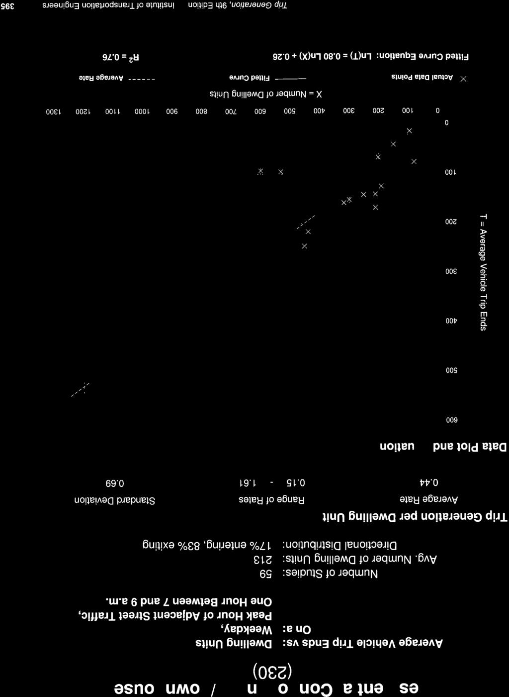
81
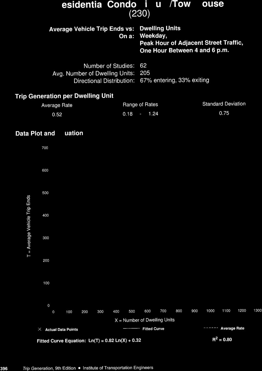
82
83 IBI GROUP TRANSPORTATION IMPACT ASSESSMENT SECOND SUBMISSION PROPOSED RESIDENTIAL BUILDING BANK AT FIFTH (99 FIFTH AVENUE) Prepared for Minto Communities Canada APPENDIX E TDM-SUPPORTIVE DEVELOPMENT DESIGN & INFRASTRUCTURE CHECKLIST May 8, 2018
84 TDM-Supportive Development Design and Infrastructure Checklist Version 1.0 (30 June 2017) City of Ottawa TDM-Supportive Development Design and Infrastructure Checklist: Residential Developments (multi-family or condominium) Legend REQUIRED The Official Plan or Zoning By-law provides related guidance that must be followed BASIC BETTER The measure is generally feasible and effective, and in most cases would benefit the development and its users The measure could maximize support for users of sustainable modes, and optimize development performance BASIC BASIC BASIC TDM-supportive design & infrastructure measures: Residential developments 1. WALKING & CYCLING: ROUTES 1.1 Building location & access points Locate building close to the street, and do not locate parking areas between the street and building entrances Locate building entrances in order to minimize walking distances to sidewalks and transit stops/stations Locate building doors and windows to ensure visibility of pedestrians from the building, for their security and comfort 1.2 Facilities for walking & cycling REQUIRED Provide convenient, direct access to stations or major stops along rapid transit routes within 600 metres; minimize walking distances from buildings to rapid transit; provide pedestrian-friendly, weather-protected (where possible) environment between rapid transit accesses and building entrances; ensure quality linkages from sidewalks through building entrances to integrated stops/stations (see Official Plan policy 4.3.3) REQUIRED Provide safe, direct and attractive pedestrian access from public sidewalks to building entrances through such measures as: reducing distances between public sidewalks and major building entrances; providing walkways from public streets to major building entrances; within a site, providing walkways along the front of adjoining buildings, between adjacent buildings, and connecting areas where people may congregate, such as courtyards and transit stops; and providing weather protection through canopies, colonnades, and other design elements wherever possible (see Official Plan policy ) Check if completed & add descriptions, explanations or plan/drawing references A1.2 & A2.3 A1.2 & A2.3 A A1.2 & A2.3 Main entrance into building lobby is located at the same intersection as near by bus stops. Access to cross walk. A1.2 & A2.3 Main entrance into building located as close to major pedestrian walkways/transit stops as possible. 10
85 TDM-Supportive Development Design and Infrastructure Checklist Version 1.0 (30 June 2017) City of Ottawa TDM-supportive design & infrastructure measures: Residential developments REQUIRED Provide sidewalks of smooth, well-drained walking surfaces of contrasting materials or treatments to differentiate pedestrian areas from areas, and provide marked pedestrian crosswalks at intersection sidewalks (see Official Plan policy ) REQUIRED Make sidewalks and open space areas easily accessible through features such as gradual grade transition, depressed curbs at street corners and convenient access to extra-wide parking spaces and ramps (see Official Plan policy ) REQUIRED Include adequately spaced inter-block/street cycling and pedestrian connections to facilitate travel by active transportation. Provide links to the existing or planned network of public sidewalks, multi-use pathways and onroad cycle routes. Where public sidewalks and multi-use pathways intersect with roads, consider providing traffic control devices to give priority to cyclists and pedestrians (see Official Plan policy ) BASIC BASIC BASIC BASIC BASIC Provide safe, direct and attractive walking routes from building entrances to nearby transit stops Ensure that walking routes to transit stops are secure, visible, lighted, shaded and wind-protected wherever possible Design roads used for access or circulation by cyclists using a target operating speed of no more than 30 km/h, or provide a separated cycling facility 1.3 Amenities for walking & cycling Provide lighting, landscaping and benches along walking and cycling routes between building entrances and streets, sidewalks and trails Provide wayfinding signage for site access (where required, e.g. when multiple buildings or entrances exist) and egress (where warranted, such as when directions to reach transit stops/stations, trails or other common destinations are not obvious) Check if completed & add descriptions, explanations or plan/drawing references A1.2 & A2.3 A1.2 & A2.3 A1.2 & A2.3 A1.2 & A2.3 A1.2 & A2.3 A1.2 & A2.3 11
86 TDM-Supportive Development Design and Infrastructure Checklist Version 1.0 (30 June 2017) City of Ottawa TDM-supportive design & infrastructure measures: Residential developments 2. WALKING & CYCLING: END-OF-TRIP FACILITIES 2.1 Bicycle parking REQUIRED Provide bicycle parking in highly visible and lighted areas, sheltered from the weather wherever possible (see Official Plan policy 4.3.6) REQUIRED Provide the number of bicycle parking spaces specified for various land uses in different parts of Ottawa; provide convenient access to main entrances or wellused areas (see Zoning By-law Section 111) REQUIRED Ensure that bicycle parking spaces and access aisles meet minimum dimensions; that no more than 50% of spaces are vertical spaces; and that parking racks are securely anchored (see Zoning By-law Section 111) BASIC Provide bicycle parking spaces equivalent to the expected number of resident-owned bicycles, plus the expected peak number of visitor cyclists 2.2 Secure bicycle parking REQUIRED Where more than 50 bicycle parking spaces are provided for a single residential building, locate at least 25% of spaces within a building/structure, a secure area (e.g. supervised parking lot or enclosure) or bicycle lockers (see Zoning By-law Section 111) BETTER BETTER BASIC BASIC BETTER Provide secure bicycle parking spaces equivalent to at least the number of units at condominiums or multifamily residential developments 2.3 Bicycle repair station Provide a permanent bike repair station, with commonly used tools and an air pump, adjacent to the main bicycle parking area (or secure bicycle parking area, if provided) 3. TRANSIT 3.1 Customer amenities Provide shelters, lighting and benches at any on-site transit stops Where the site abuts an off-site transit stop and insufficient space exists for a transit shelter in the public right-of-way, protect land for a shelter and/or install a shelter Provide a secure and comfortable interior waiting area by integrating any on-site transit stops into the building Check if completed & add descriptions, explanations or plan/drawing references A2.1-3 All bike parking for residential portion of site is provided below grade with access to lobby/building through elevator. Bike racks for existing retail to remain located on Bank (no change proposed) A % of bike parking/locker space provided in secure area within the building A2.2-3 bicycle parking/storage lockers provided at 1 to 1. 12
87 TDM-Supportive Development Design and Infrastructure Checklist Version 1.0 (30 June 2017) City of Ottawa BASIC TDM-supportive design & infrastructure measures: Residential developments 4. RIDESHARING 4.1 Pick-up & drop-off facilities Provide a designated area for carpool drivers (plus taxis and ride-hailing services) to drop off or pick up passengers without using fire lanes or other no-stopping zones 5. CARSHARING & BIKESHARING 5.1 Carshare parking spaces BETTER Provide up to three carshare parking spaces in an R3, R4 or R5 Zone for specified residential uses (see Zoning By-law Section 94) BETTER 5.2 Bikeshare station location Provide a designated bikeshare station area near a major building entrance, preferably lighted and sheltered with a direct walkway connection 6. PARKING 6.1 Number of parking spaces REQUIRED Do not provide more parking than permitted by zoning, nor less than required by zoning, unless a variance is being applied for BASIC BASIC BETTER BETTER Provide parking for long-term and short-term users that is consistent with mode share targets, considering the potential for visitors to use off-site public parking Where a site features more than one use, provide shared parking and reduce the cumulative number of parking spaces accordingly (see Zoning By-law Section 104) Reduce the minimum number of parking spaces required by zoning by one space for each 13 square metres of gross floor area provided as shower rooms, change rooms, locker rooms and other facilities for cyclists in conjunction with bicycle parking (see Zoning By-law Section 111) 6.2 Separate long-term & short-term parking areas Provide separate areas for short-term and long-term parking (using signage or physical barriers) to permit access controls and simplify enforcement (i.e. to discourage residents from parking in visitor spaces, and vice versa) Check if completed & add descriptions, explanations or plan/drawing references A1.2 & A2.3 A2.1-3 Providing close to 1 parking space per unit A2.1-3 Visitor parking provided at grade w/ resident and remaining visitor parking U/G A2.2 13
88 IBI GROUP TRANSPORTATION IMPACT ASSESSMENT SECOND SUBMISSION PROPOSED RESIDENTIAL BUILDING BANK AT FIFTH (99 FIFTH AVENUE) Prepared for Minto Communities Canada APPENDIX F TDM MEASURES CHECKLIST May 8, 2018
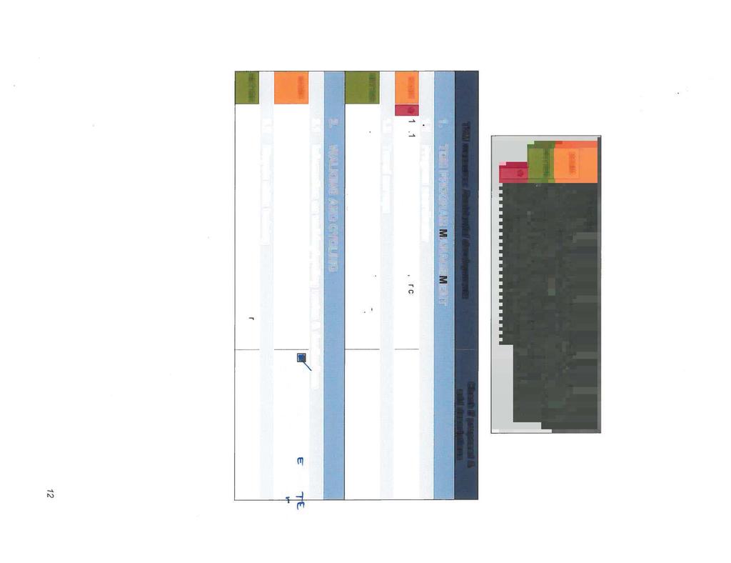
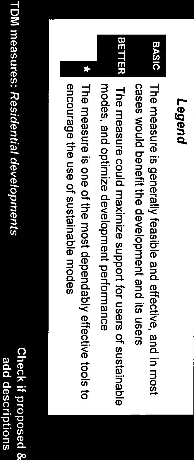
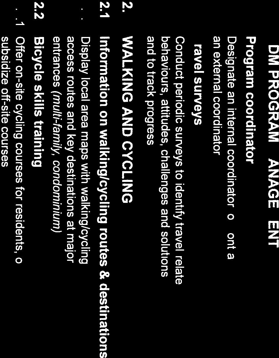


89


90


91
92 IBI GROUP TRANSPORTATION IMPACT ASSESSMENT SECOND SUBMISSION PROPOSED RESIDENTIAL BUILDING BANK AT FIFTH (99 FIFTH AVENUE) Prepared for Minto Communities Canada APPENDIX G INTERSECTION CAPACITY ANALYSIS May 8, 2018


93
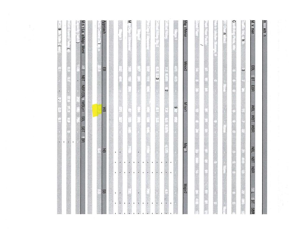
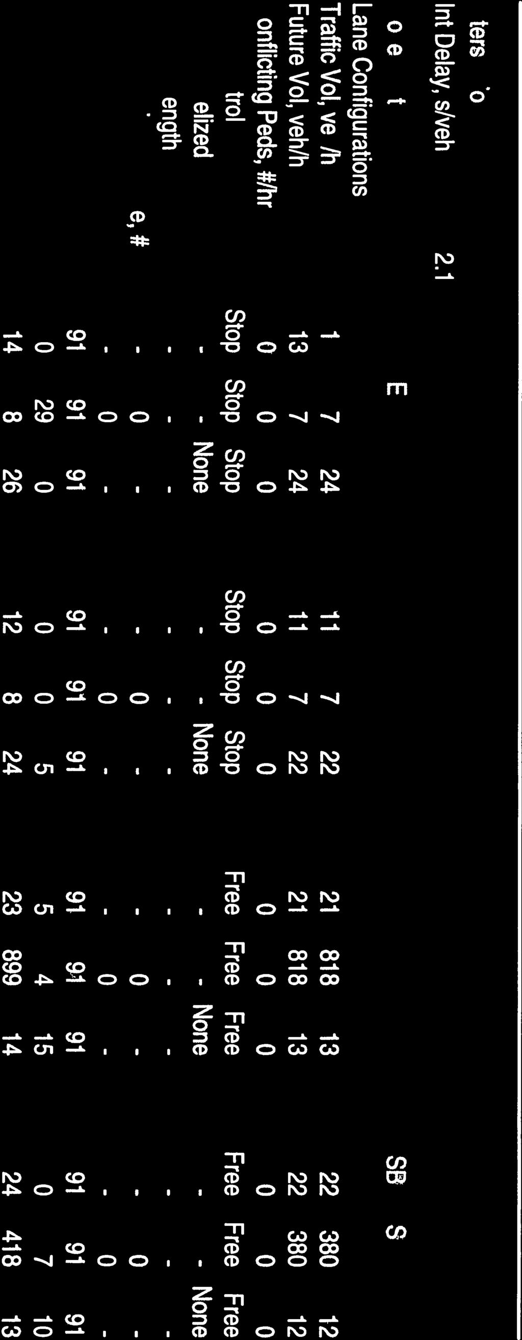

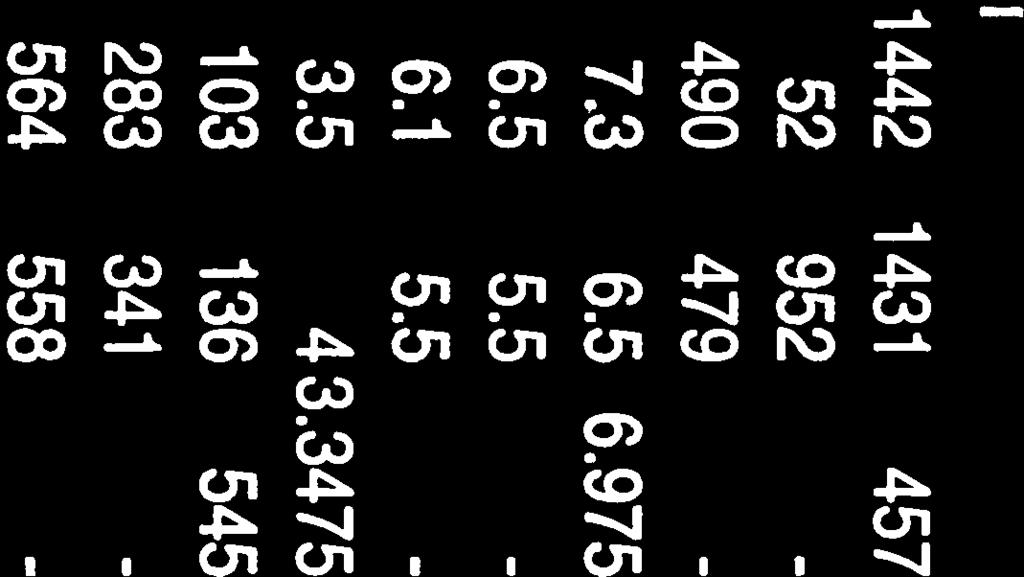


94
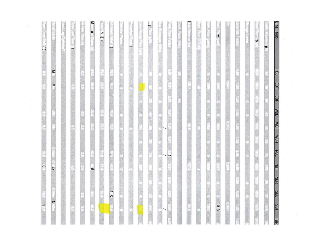


95
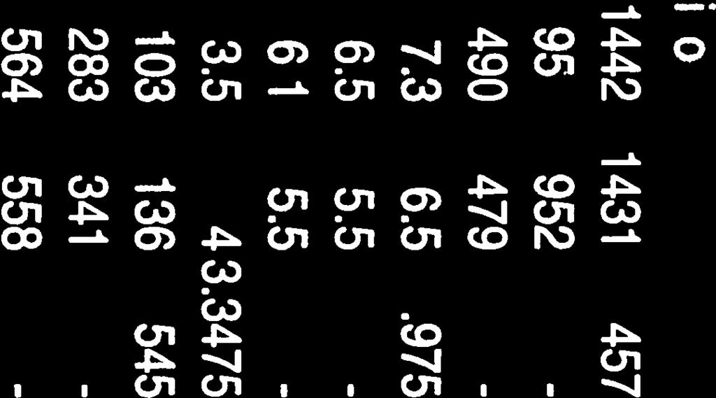
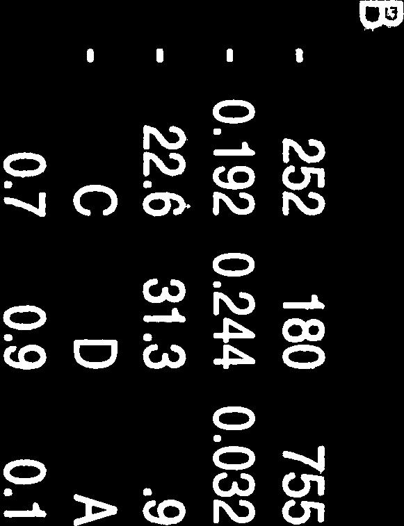


96
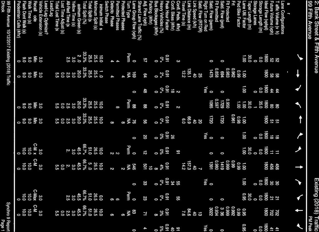


97
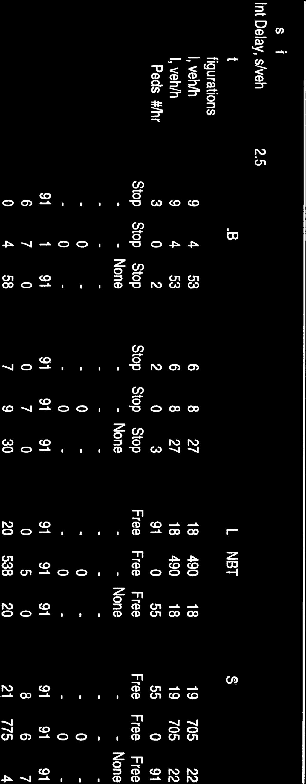
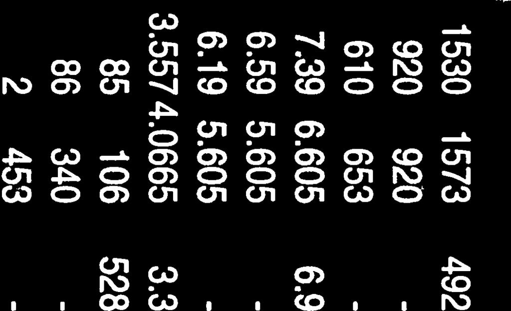
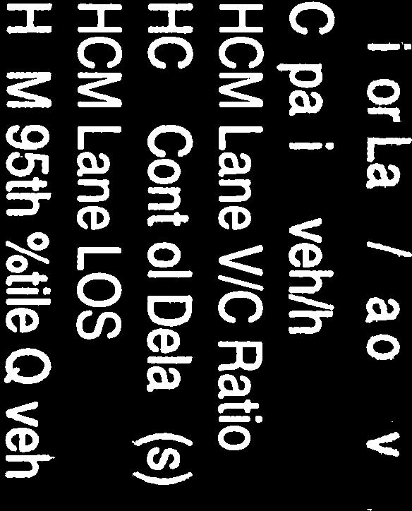
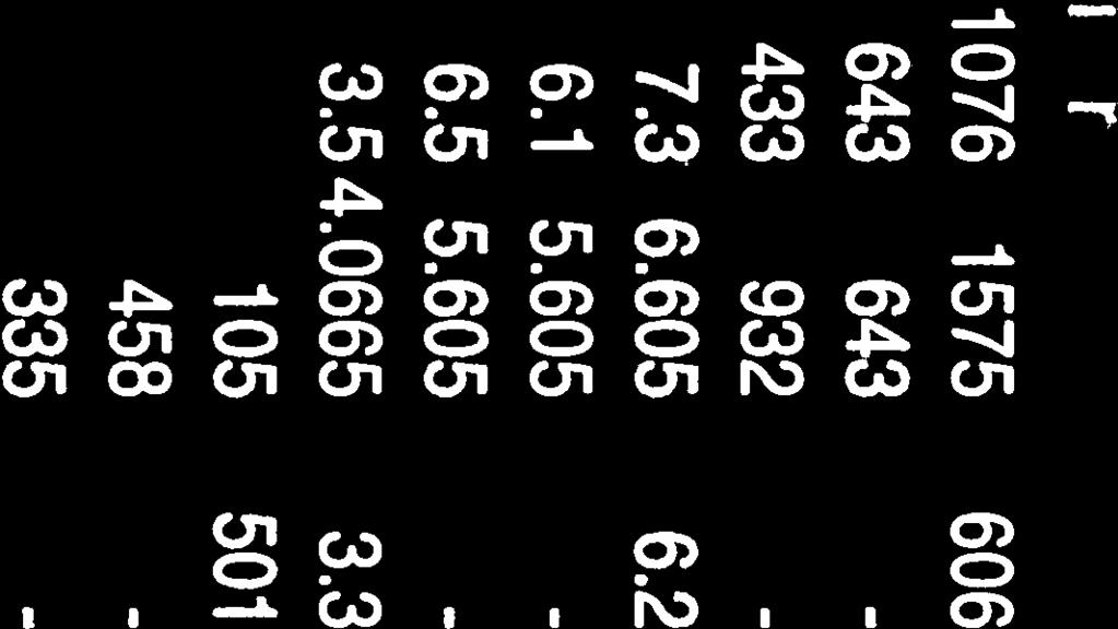


98
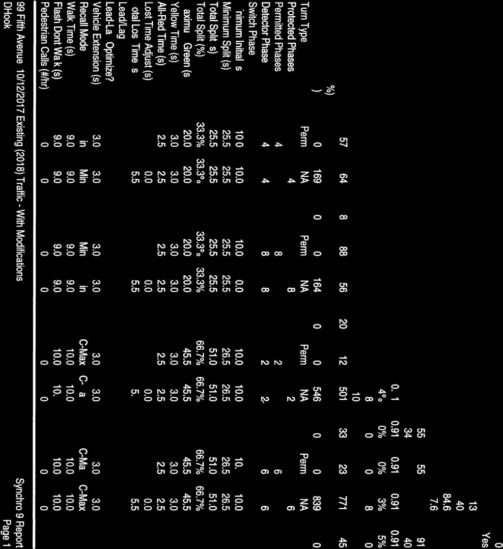
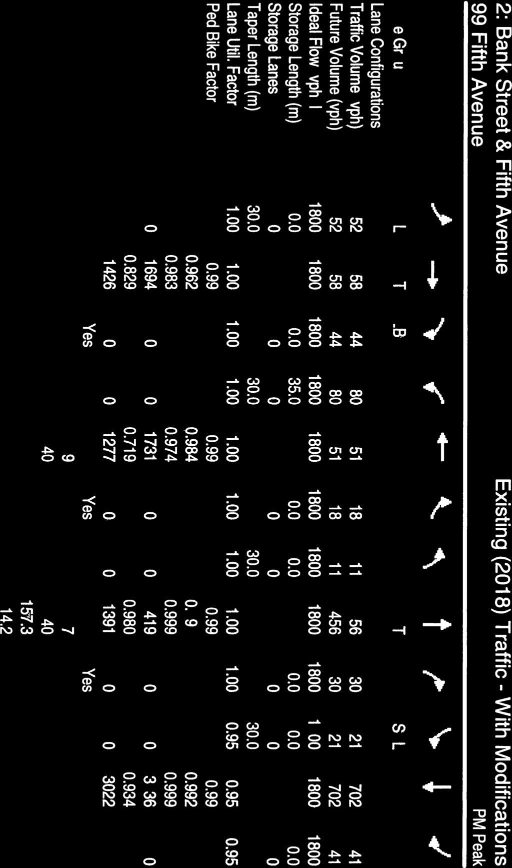
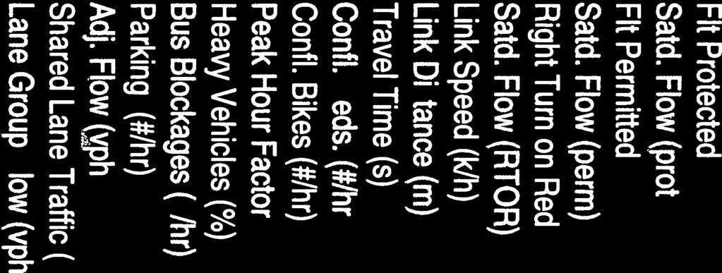


99


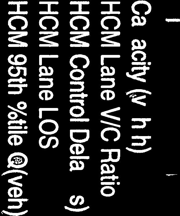


100
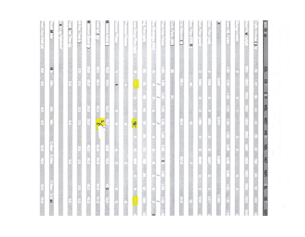


101
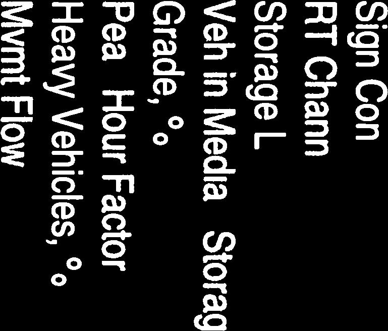
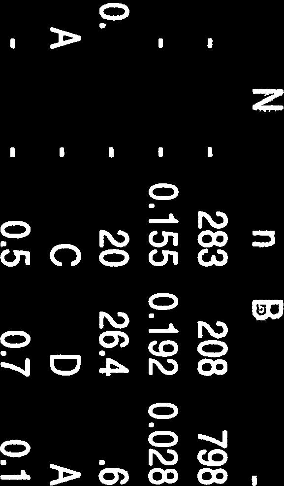


102


103
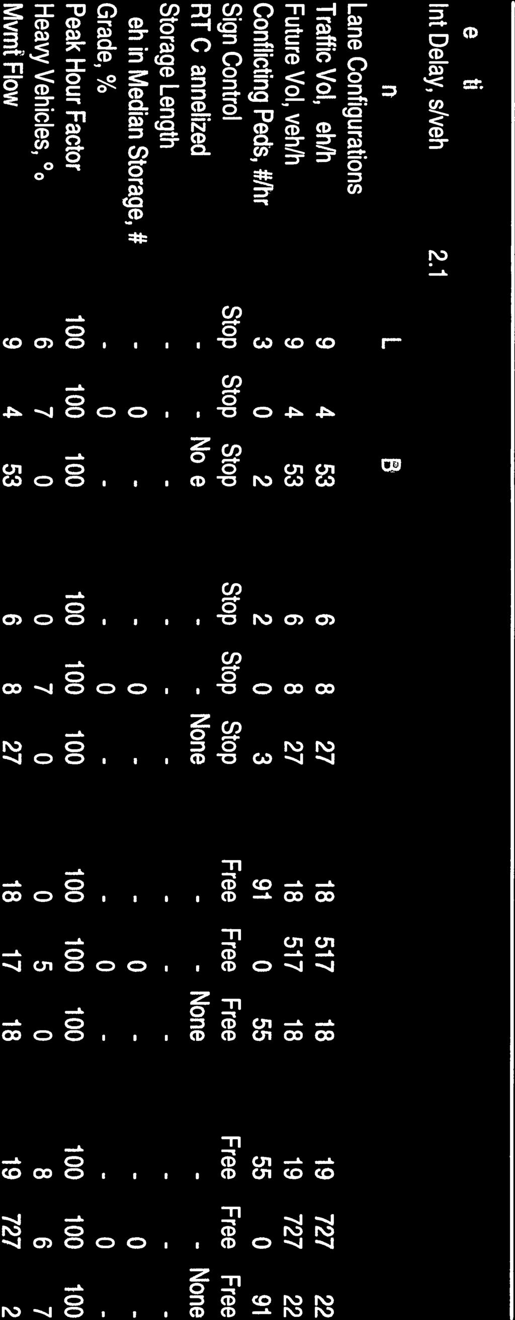
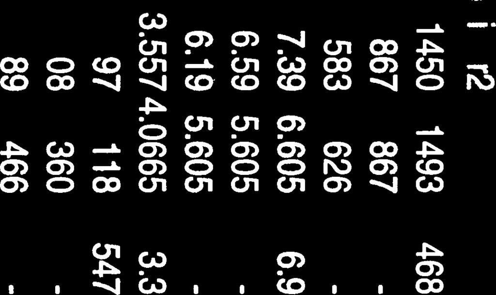
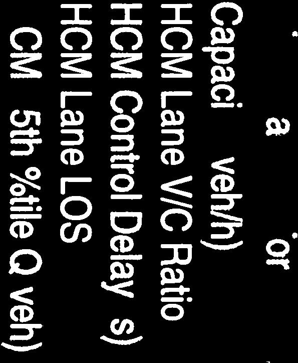


104


105


106
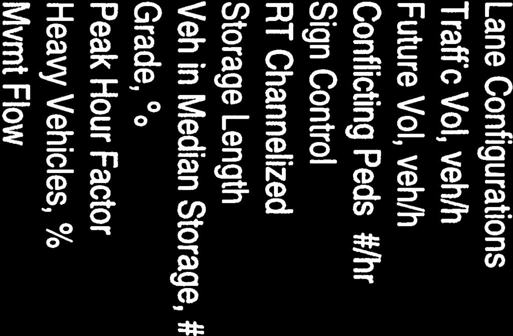

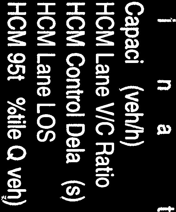


107


108
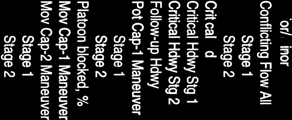

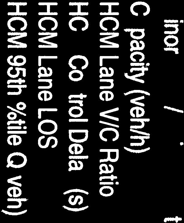


109
CPC Parking Lot Riverside Drive. Transportation Rationale
 CPC Parking Lot Transportation Rationale Prepared By: NOVATECH Suite 200, 240 Michael Cowpland Drive Ottawa, Ontario K2M 1P6 September 2015 Novatech File: 114093 Ref: R-2015-153 Table of Contents 1.0 INTRODUCTION...
BLUE SEA VILLAGE MER BLEUE 2159 MER BLEUE ROAD OTTAWA, ONTARIO TRANSPORTATION IMPACT ASSESSMENT. Prepared for: Ontario Limited.
 BLUE SEA VILLAGE MER BLEUE 2159 MER BLEUE ROAD OTTAWA, ONTARIO TRANSPORTATION IMPACT ASSESSMENT Prepared for: 2534189 Ontario Limited April 6, 2018 117-668 TIA Report_2.doc D. J. Halpenny & Associates
HENDERSON DEVELOPMENT 213, 217, 221, 221 ½, 223 HENDERSON AVENUE and 65 TEMPLETON STREET OTTAWA, ONTARIO TRANSPORTATION OVERVIEW.
 HENDERSON DEVELOPMENT 213, 217, 221, 221 ½, 223 HENDERSON AVENUE and 65 TEMPLETON STREET OTTAWA, ONTARIO TRANSPORTATION OVERVIEW Prepared for: 2294170 Ontario Inc. February 2, 2017 117-652 Report_1.doc
CITY OF OTTAWA ROADWAY MODIFICATION APPROVAL UNDER DELEGATED AUTHORITY
 RMA-2015-ATM-038 CITY OF OTTAWA ROADWAY MODIFICATION APPROVAL UNDER DELEGATED AUTHORITY DATE: April 22, 2015 SUBJECT Approval of Roadway Modifications Recommended through an Area Traffic Management Study
OFFICE/RETAIL DEVELOPMENT 1625 BANK STREET OTTAWA, ONTARIO TRANSPORTATION BRIEF. Prepared for: Canada Inc.
 OFFICE/RETAIL DEVELOPMENT 1625 BANK STREET OTTAWA, ONTARIO TRANSPORTATION BRIEF Prepared for: 9402209 Canada Inc. December 15, 2015 115-625 Report_2.doc D. J. Halpenny & Associates Ltd. Consulting Transportation
APPENDIX 2 LAKESHORE ROAD TRANSPORTATION REVIEW STUDY EXECUTIVE SUMMARY
 APPENDIX 2 LAKESHORE ROAD TRANSPORTATION REVIEW STUDY EXECUTIVE SUMMARY Appendix 2 City of Mississauga Lakeshore Road FINAL REPORT Transportation Review Study December 2010 EXECUTIVE SUMMARY Study Purpose
9 Leeming Drive Redevelopment Ottawa, ON Transportation Brief. Prepared By: Stantec Consulting Ltd.
 9 Leeming Drive Redevelopment Ottawa, ON Transportation Brief Prepared By: Stantec Consulting Ltd. TIA GUIDELINES CHECKLIST Report Context Municipal Address Comment: Section 1.1 Location relative to major
Glebe Neighbourhood Cycling Plan
 Glebe Neighbourhood Cycling Plan Summary of Public Comments received after June 5 th Public Information Session Comment STUDY NETWORK CS9, CS8, E, E0 CS4, E CS4 CS8 E Suggestions for alternate cycling
INDUSTRIAL BUILDING 3009 HAWTHORNE ROAD CITY OF OTTAWA TRANSPORTATION OVERVIEW REVISED. Prepared for: Canada Inc.
 INDUSTRIAL BUILDING 3009 HAWTHORNE ROAD CITY OF OTTAWA TRANSPORTATION OVERVIEW REVISED Prepared for: 7849648 Canada Inc. Octiober 1, 2015 114-598 Overview_2.doc D. J. Halpenny & Associates Ltd. Consulting
Prepared For: Shieldbay Developments Inc. c/o Matson, McConnell Ltd. 2430A Bloor Street West Toronto, Ontario M6S 1P9.
 Prepared For: Shieldbay Developments Inc. c/o Matson, McConnell Ltd. 2430A Bloor Street West Toronto, Ontario M6S 1P9 Prepared By: URS Canada Inc. 4 th Floor, 30 Leek Crescent Richmond Hill, Ontario L4B
MEDICAL/OFFICE BUILDING 1637 BANK STREET OTTAWA, ONTARIO TRANSPORTATION OVERVIEW. Prepared for:
 MEDICAL/OFFICE BUILDING 1637 BANK STREET OTTAWA, ONTARIO TRANSPORTATION OVERVIEW Prepared for: 2434984 Ontario Inc. 13-5510 Canotek Road Ottawa, Ontario K1J 9J5 June 4, 2015 115-613 Report_2.doc D. J.
10.0 CURB EXTENSIONS GUIDELINE
 10.0 CURB EXTENSIONS GUIDELINE Road Engineering Design Guidelines Version 1.0 March 2017 City of Toronto, Transportation Services City of Toronto Page 0 Background In early 2014, Transportation Services
Classification Criteria
 SCHEDULE D TO RECOMMENDED OFFICIAL PLAN AMENDMENT NO. 40 SCHEDULE C-4 Road Criteria Criteria Traffic Service Objective Land Service/Access Typical Daily Traffic Volume Flow characteristics Travel Speed
OTTAWA TRAIN YARDS PHASE 3 DEVELOPMENT CITY OF OTTAWA TRANSPORTATION IMPACT STUDY. Prepared for:
 OTTAWA TRAIN YARDS PHASE 3 DEVELOPMENT CITY OF OTTAWA TRANSPORTATION IMPACT STUDY Prepared for: The Ottawa Train Yards Inc. 223 Colonnade Road South, Suite 212 Nepean, Ontario K2E 7K3 January 17, 2012
485 Ancaster Avenue. Transportation Impact Assessment. Engineering. Planning. Landscape Architecture
 Engineering Land / Site Development Municipal Infrastructure Environmental / Water Resources Traffic / Transportation Structural Recreational 485 Ancaster Avenue Transportation Impact Assessment Planning
EUCLID AVENUE PARKING STUDY CITY OF SYRACUSE, ONONDAGA COUNTY, NEW YORK
 EUCLID AVENUE PARKING STUDY CITY OF SYRACUSE, ONONDAGA COUNTY, NEW YORK CITY OF SYRACUSE DEPARTMENT OF PUBLIC WORKS 1200 CANAL STREET EXTENSION SYRACUSE, NEW YORK 13210 DRAFT REPORT DATE: November 13,
South Albion-Bolton Community Plan North Hill Supermarket Transportation Study Part B: Evaluation of Alternatives
 Community Plan North Hill Supermarket Transportation Study Part B: Evaluation of Alternatives Prepared for: The Town of Caledon August 9 Transportation Solutions Ltd. 43 Forest Road Cambridge, ON N1S 3B4
Access Management Guidelines February 2013 THE CITY OF
 Access Management Guidelines February 2013 THE CITY OF Table of Contents Introduction 2 Review and Approval Process 5 Technical Guidelines 9... 10... 12 3. Separation Distance: Non-Signalized All-Turns
December 15, City of Ottawa Planning and Growth Management Branch 110 Laurier Ave. W., 4 th Floor Ottawa, ON K1P 1J1
 December 15, 2017 City of Ottawa Planning and Growth Management Branch 110 Laurier Ave. W., 4 th Floor Ottawa, ON K1P 1J1 Attention: Mr. Wally Dubyk, C.E.T. Project Manager, Infrastructure Approvals Dear
Having held a public hearing, that Council approve:
 3. MODIFICATIONS TO MERIVALE ROAD FROM FALLOWFIELD ROAD TO OLD HIGHWAY 16 TO ACCOMMODATE THE GROWTH WITHIN THE SOUTH MERIVALE BUSINESS PARK - PUBLIC HEARING COMMITTEE RECOMMENDATIONS Having held a public
19 July 2016 OUR REF:
 19 July 2016 OUR REF: 602263-01000 194168 Ontario Ltd. 320 McRae Street Ottawa, ON K1Z 5R8 Attention: Brian Casagrande Dear Brian: Re: 320 McRae/1976 Scott Redevelopment CTS Addendum #1 This Addendum has
TRAFFIC IMPACT ANALYSIS
 TRAFFIC IMPACT ANALYSIS FOR THE CHAMPAIGN UNIT#4 SCHOOL DISTRICT PROPOSED HIGH SCHOOL (SPALDING PARK SITE) IN THE CITY OF CHAMPAIGN Final Report Champaign Urbana Urbanized Area Transportation Study 6/24/2014
Magnolia Place. Traffic Impact Analysis. Prepared for: City of San Mateo. Prepared by: Hexagon Transportation Consultants, Inc.
 Magnolia Place Traffic Impact Analysis Prepared for: City of San Mateo Prepared by: Hexagon Transportation Consultants, Inc. Updated January 4, 2010 Table of Contents 1. Introduction...1 2. Existing Conditions...6
Implementing Complete Streets in Ottawa. Project Delivery Process and Tools Complete Streets Forum 2015 October 1, 2015
 Implementing Complete Streets in Ottawa October 1, 2015 The Essentials Complete Streets Implementation Framework will become part of the routine delivery of City transportation projects Approach uses every
INDUSTRIAL BUILDING 1660 COMSTOCK ROAD CITY OF OTTAWA TRANSPORTATION OVERVIEW. Prepared for:
 INDUSTRIAL BUILDING 1660 COMSTOCK ROAD CITY OF OTTAWA TRANSPORTATION OVERVIEW Prepared for: Simluc Contractors Limited 2550 Blackwell Street, Ottawa K1B 5R1 October 18, 2013 113-584 Overview_1.doc D. J.
EXECUTIVE SUMMARY OF CALEDON TRANSPORTATION NEEDS STUDY
 EXECUTIVE SUMMARY OF CALEDON TRANSPORTATION NEEDS STUDY The Caledon Transportation Needs Study has been undertaken as a joint project by the Town of Caledon and the Region of Peel to determine the existing
Barrhaven South Urban Expansion Study Area Community Design Plan
 Barrhaven South Urban Expansion Study Area Community Design Plan FINAL Transportation Master Study Ottawa, Ontario Prepared for: Minto Communities Prepared by: Stantec Consulting Ltd. February 2018 Project
MEETING FACILITY 2901 GIBFORD DRIVE CITY OF OTTAWA TRANSPORTATION BRIEF. Prepared for: Holiday Inn Express 2881 Gibford Drive Ottawa, ON K1V 2L9
 MEETING FACILITY 2901 GIBFORD DRIVE CITY OF OTTAWA TRANSPORTATION BRIEF Prepared for: Holiday Inn Express 2881 Gibford Drive Ottawa, ON K1V 2L9 December 18, 2012 112-566 Brief_1.doc D. J. Halpenny & Associates
TRAFFIC STUDY GUIDELINES Clarksville Street Department
 TRAFFIC STUDY GUIDELINES Clarksville Street Department 9/1/2009 Introduction Traffic studies are used to help the city determine potential impacts to the operation of the surrounding roadway network. Two
SECTION 1 - TRAFFIC PLANNING
 SECTION 1 - TRAFFIC PLANNING 1.1 TRAFFIC OPERATIONS 1.1.1 Roadway Functional Classification The Multnomah County Comprehensive Framework Plan s Policy 34: Trafficways and the Functional Classification
2.0 LANE WIDTHS GUIDELINE
 2.0 LANE WIDTHS GUIDELINE Road Engineering Design Guidelines Version 2.0.1 May 2018 City of Toronto, Transportation Services City of Toronto Page 0 Background In early 2014, Transportation Services initiated
TRAFFIC CALMING GUIDE FOR TORONTO CITY OF TORONTO TRANSPORTATION SERVICES DIVISION
 TRAFFIC CALMING GUIDE FOR TORONTO CITY OF TORONTO TRANSPORTATION SERVICES DIVISION CITY OF TORONTO TRANSPORTATION SERVICES DIVISION 2016 TRAFFIC CALMING GUIDE FOR TORONTO TABLE OF CONTENTS Introduction
HOLIDAY INN HOTEL 235 KING EDWARD AVENUE CITY OF OTTAWA TRANSPORTATION BRIEF. Prepared for:
 HOLIDAY INN HOTEL 235 KING EDWARD AVENUE CITY OF OTTAWA TRANSPORTATION BRIEF Prepared for: Momentum Planning & Communications 1165 Greenlawn Crescent Ottawa, ON K1L 6C2 June 29, 2015 115-618 Brief_1.doc
QUICKIE C STORE AND GAS BAR 1780 HERON ROAD OTTAWA, ONTARIO TRANSPORTATION BRIEF. Prepared for:
 QUICKIE C STORE AND GAS BAR 1780 HERON ROAD OTTAWA, ONTARIO TRANSPORTATION BRIEF Prepared for: Quickie Convenience Stores Larny Holdings Ltd. c/o PBC Group April 15, 2015 115-615 Report_1.doc D. J. Halpenny
4. ENVIRONMENTAL IMPACT ANALYSIS 9. TRANSPORTATION AND TRAFFIC
 4. ENVIRONMENTAL IMPACT ANALYSIS 9. TRANSPORTATION AND TRAFFIC 4.9.1 INTRODUCTION The following section addresses the Proposed Project s impact on transportation and traffic based on the Traffic Study
Main-McVay Transit Study: Phase 2 Options Definition and High Level Constraints Evaluation
 Main-McVay Transit Study: Phase 2 Options Definition and High Level Constraints Evaluation APRIL 2016 A collaborative study between: For Additional Information or to Comment If you would like additional
URBAN QUARRY HEADQUARTERS 2717 STEVENAGE DRIVE CITY OF OTTAWA TRANSPORTATION OVERVIEW. Prepared for: Urban Quarry 4123 Belgreen Drive, Ottawa K1G 3N2
 URBAN QUARRY HEADQUARTERS 2717 STEVENAGE DRIVE CITY OF OTTAWA TRANSPORTATION OVERVIEW Prepared for: Urban Quarry 4123 Belgreen Drive, Ottawa K1G 3N2 February 27, 2014 113-584 Overview_1.doc D. J. Halpenny
TRANSPORTATION ANALYSIS REPORT US Route 6 Huron, Erie County, Ohio
 TRANSPORTATION ANALYSIS REPORT US Route 6 Huron, Erie County, Ohio December 12, 2012 Prepared for: The City of Huron 417 Main Huron, OH 44839 Providing Practical Experience Technical Excellence and Client
Moving Cambridge. City of Cambridge Transportation Master Plan Public Consultation Centre. March 7, :00 8:00 PM.
 City of Cambridge Transportation Master Plan Public Consultation Centre March 7, 2018 5:00 8:00 PM Region of Waterloo City of Cambridge Transportation Master Plan Public Consultation Centre March 7, 2018
THIS PAGE LEFT BLANK INTENTIONALLY
 GA SR 25 Spur at Canal Road Transportation Impact Analysis PREPARED FOR GLYNN COUNTY, GEORGIA 1725 Reynolds Street, Suite 300 Brunswick, Georgia 31520 PREPARED BY 217 Arrowhead Boulevard Suite 26 Jonesboro,
CastleGlenn Consultants Inc.
 February 1 st, 2010 CastleGlenn Consultants Inc. Engineers, Project Managers & Planners Mr. Kevin Yemm Planning and Land Development Richraft Ltd. 2280 St. Laurent Boulevard Suite 201 Ottawa, Ontario (Tel:
List of Exhibits...ii
 One Brickell Traffic Study TABLE OF CONTENTS List of Exhibits...ii EXECUTIVE SUMMARY...1 1. INTRODUCTION...2 1.1 Study Area...2 1.2 Study Objective...5 2. EXISTING TRAFFIC CONDITIONS...6 2.1 Data Collection...6
Corporate. Report COUNCIL DATE: May 25, 1998 NO: R1500 REGULAR COUNCIL. TO: Mayor & Council DATE: April 27, 1998
 R1500 : Traffic Safety at 25 Avenue and 128 Street Intersection Corporate NO: R1500 Report COUNCIL DATE: May 25, 1998 REGULAR COUNCIL TO: Mayor & Council DATE: April 27, 1998 FROM: General Manager, Engineering
Traffic Impact Analysis Chatham County Grocery Chatham County, NC
 Chatham County Grocery Chatham County, NC TABLE OF CONTENTS 1. INTRODUCTION... 1 1.1. Location and Study Area... 1 1.2. Proposed Land Use and Access... 2 1.3. Adjacent Land Uses... 2 1.4. Existing ways...
St. Stefan Serbian Orthodox Church 1989 and 1993 Prince of Wales Drive, Ottawa REVISED TRANSPORTATION BRIEF
 St. Stefan Serbian Orthodox Church 1989 and 1993 Prince of Wales Drive, Ottawa REVISED TRANSPORTATION BRIEF Prepared By: NOVATECH ENGINEERING CONSULTANTS LTD. Suite 200, 240 Michael Cowpland Drive Ottawa,
COMMERCIAL DEVELOPMENT 2015 ROBERTSON ROAD OTTAWA, ONTARIO TRANSPORTATION BRIEF. Prepared for:
 COMMERCIAL DEVELOPMENT 2015 ROBERTSON ROAD OTTAWA, ONTARIO TRANSPORTATION BRIEF Prepared for: First Bay Properties Inc. 311 Richmond Road, Suite 203 Ottawa, ON K1Z 6X3 August 8, 2017 117-663 Brief_1.doc
Sixth Line Development - Transit Facilities Plan
 Memorandum Date: November 13, 2012 To: From: c.c. Subject: Rob Freeman (Freeman Planning) Kevin Phillips Sixth Line Development - Transit Facilities Plan 33016631 This memo was prepared to review the transit
Improving Cyclist Safety at the Dundas Street West and Sterling Road Intersection
 STAFF REPORT ACTION REQUIRED Improving Cyclist Safety at the Dundas Street West and Sterling Road Intersection Date: August 17, 2012 To: From: Wards: Reference Number: Public Works and Infrastructure Committee
CPC Parking Lot Riverside Drive. Transportation Brief
 CPC Parking Lot 2785 Riverside Drive Transportation Brief Prepared By: NOVATECH Suite 2, 24 Michael Cowpland Drive Ottawa, Ontario K2M P6 7 / 5 / 25 Novatech File: 49 Ref: R-25-22 July 5 th, 25 City of
City of Homewood Transportation Plan
 City of Homewood Transportation Plan Prepared for: City of Homewood, Alabama Prepared by: Skipper Consulting, Inc. May 2007 TABLE OF CONTENTS INTRODUCTION... 1 BACKGROUND INFORMATION... 1 EXISTING TRANSPORTATION
3.16 TRANSPORTATION, CIRCULATION, AND PARKING Regulatory Setting Environmental Setting ROADWAY SYSTEM
 3.16 TRANSPORTATION, CIRCULATION, AND PARKING This section assesses the potential for implementation of the Orchard Park Redevelopment component of the 2018 LRDP to result in impacts related to transportation,
5858 N COLLEGE, LLC N College Avenue Traffic Impact Study
 5858 N COLLEGE, LLC nue Traffic Impact Study August 22, 2016 Contents Traffic Impact Study Page Preparer Qualifications... 1 Introduction... 2 Existing Roadway Conditions... 5 Existing Traffic Conditions...
2. executing a legal agreement with respect to the above.
 2. MODIFICATIONS TO INNES ROAD AND BLAIR ROAD INTERSECTION TO ACCOMMODATE THE CONSTRUCTION OF THE INNES CENTRE - PUBLIC HEARING COMMITTEE RECOMMENDATION Having held a public hearing, that Council approve
City of Memphis On-Street Parking Modification Guidelines
 City of Memphis Effective Date: December 1, 2013 Bicycle/Pedestrian Program 125 N. Main Street Memphis, TN 38103 (901) 576-6710 www.bikepedmemphis.com City of Memphis Executive Summary It is current practice
Public Information Centre
 WELCOME Public Information Centre Father Tobin Road Lougheed Middle School - Library Wednesday November 7, 2012 7:00 p.m.to 9:00 p.m. Please sign in Neighbourhood Traffic Calming Guide Background The City
RÉGION D OTTAWA-CARLETON
 8 REGION OF OTTAWA-CARLETON RÉGION D OTTAWA-CARLETON REPORT RAPPORT Our File/N/Réf. Your File/V/Réf. 50 23-00-R030-H DATE 14 July 2000 TO/DEST. FROM/EXP. SUBJECT/OBJET Co-ordinator Transportation Committee
May 5, 2009 File:
 MMM Group Limited Suite 600 1455 West Georgia Street Vancouver, BC V6G 2T3 t: 604-685-9381 f: 604-683-8655 www.mmm.ca May 5, 2009 File: 50-09001-007 1420 1055 West Hastings Street Vancouver, BC V6E 2E9
Shockoe Bottom Preliminary Traffic and Parking Analysis
 Shockoe Bottom Preliminary Traffic and Parking Analysis Richmond, Virginia August 14, 2013 Prepared For City of Richmond Department of Public Works Prepared By 1001 Boulders Pkwy Suite 300, Richmond, VA
City of Wayzata Comprehensive Plan 2030 Transportation Chapter: Appendix A
 A1. Functional Classification Table A-1 illustrates the Metropolitan Council s detailed criteria established for the functional classification of roadways within the Twin Cities Metropolitan Area. Table
Parking Lot P6C Transportation Impact Assessment
 Transportation Carleton University Parking Lot P6C Transportation Impact Assessment Prepared by: AECOM 302 1150 Morrison Drive 613 820 8282 tel Ottawa, ON, Canada K2H 8S9 613 820 8338 fax www.aecom.com
Appendix C. NORTH METRO STATION AREA TRAFFIC IMPACT STATEMENT 88th Avenue Station
 Appendix C NORTH METRO STATION AREA TRAFFIC IMPACT STATEMENT 88th Avenue Station Prepared for: Regional Transportation Department and URS Corporation as part of the North Metro EIS David Evans and Associates,
APARTMENT BUILDING DEVELOPMENT 1161 HERON ROAD OTTAWA, ONTARIO TRANSPORTATION IMPACT STUDY. Prepared for:
 APARTMENT BUILDING DEVELOPMENT 1161 HERON ROAD OTTAWA, ONTARIO TRANSPORTATION IMPACT STUDY Prepared for: 1649362 Ontario Inc. c/o Manor Park Management 231 Brittany Drive, Suite D Ottawa ON K1K 0R8 July
CITY OF HAMILTON PLANNING AND ECONOMIC DEVELOPMENT DEPARTMENT Transportation Planning and Parking Division
 CITY OF HAMILTON PLANNING AND ECONOMIC DEVELOPMENT DEPARTMENT Transportation Planning and Parking Division TO: Chair and Members Public Works Committee COMMITTEE DATE: June 18, 2018 SUBJECT/REPORT NO:
Solana Beach Comprehensive Active Transportation Strategy (CATS)
") Solana Beach Comprehensive Active Transportation Strategy (CATS) 3.0 Goals & Policies The Solana Beach CATS goals and objectives outlined below were largely drawn from the Solana Beach Circulation Element
Solana Beach Comprehensive Active Transportation Strategy (CATS) 3.0 Goals & Policies The Solana Beach CATS goals and objectives outlined below were largely drawn from the Solana Beach Circulation Element
CITY OF ALPHARETTA DOWNTOWN MASTER PLAN TRAFFIC EVALUATION
 CITY OF ALPHARETTA DOWNTOWN MASTER PLAN TRAFFIC EVALUATION June 2015 CITY OF ALPHARETTA DOWNTOWN MASTER PLAN TRAFFIC EVALUATION Introduction The Alpharetta Downtown Master Plan was developed in the fall
Chapter 3 DESIGN SPECIFICATIONS
 Brampton PathWays Planning and Design Guidelines 27 Chapter 3 DESIGN SPECIFICATIONS 3.1 CLASS 1 MULTI-USE PATH Off-road multi-use trails are the backbone of the Brampton PathWays Network. They are typically
b. executing legal agreements with respect to the above.
 4. MODIFICATIONS TO RIVERSIDE DRIVE BETWEEN UPLANDS DRIVE AND KIMBERWICK CRESCENT TO ACCOMMODATE COGNOS EXPANSION COMMITTEE RECOMMENDATION Having held a public hearing, that Council approve the construction
455 Via Verona Avenue
 TRANSPORTATION Transportation Brief 455 Via Verona Avenue Submitted to Multifaith Housing Initiative by IBI Group March 2015 Table of Contents 1.0 INTRODUCTION... 1 2.0 PROPOSED DEVELOPMENT... 1 2.1 Site
September Fernbank Road. TIA Strategy Report, Revision 2
 September 218 5969 Fernbank Road TIA Strategy Report, Revision 2 5969 Fernbank Road TIA Strategy Report prepared for: Thomas Cavanaugh Construction Limited 994 Cavanaugh Road Ashton, ON KA 1B prepared
122 Avenue: 107 Street to Fort Road
 : 107 Street to Fort Road November 24, 2015 4:30 8:00 p.m. Meeting Purpose Summarize project work completed to date Share results of public input from Phase 1 Share the draft concept plan and proposed
Introduction. Using the Checklist. TDM-Supportive Development Design and Infrastructure Checklist Version 1.0 (30 June 2017) City of Ottawa
 City of Ottawa") Introduction The s Transportation Impact Assessment (TIA) Guidelines (specifically Module 4.1 Development Design) requires proponents of qualifying developments to use the City s TDM-Supportive Development
Introduction The s Transportation Impact Assessment (TIA) Guidelines (specifically Module 4.1 Development Design) requires proponents of qualifying developments to use the City s TDM-Supportive Development
Building a Liveable Ottawa 2031 Backgrounder 5: Barrhaven/Riverside South/Leitrim
 Building a Liveable Ottawa 2031 Backgrounder 5: Barrhaven/Riverside South/Leitrim Wards 3 and 22 Official Plan Transportation Master Plan Cycling Plan Pedestrian Plan October 2013 ottawa.ca/liveableottawa
COMMITTEE RECOMMENDATIONS. That Council approve:
 4. MODIFICATIONS TO INNES ROAD (REGIONAL ROAD 30) AND TENTH LINE ROAD (REGIONAL ROAD 47) TO ACCOMMODATE THE DEVELOPMENT OF THE TRINITY COMMONS SHOPPING CENTRE COMMITTEE RECOMMENDATIONS That Council approve:
Anne Arundel County BICYCLE, PEDESTRIAN, TRANSIT ASSESSMENT GUIDELINES
 Anne Arundel County BICYCLE, PEDESTRIAN, TRANSIT ASSESSMENT GUIDELINES December 2018 TABLE OF CONTENTS I. Executive Summary 3 II. When Is A Bicycle Pedestrian Transit Assessment (BPTA) Required? 4 III.
Figure 1: East West Connector Alignment Alternatives Concept Drawing
 Page 2 of 9 Figure 1: East West Connector Alignment Alternatives Concept Drawing The Montebello Drive extension will run north south and connect Wilsonville Road to the Boones Ferry Road to Brown Road
Active Transportation Infrastructure Investment A Business Case
 Active Transportation Infrastructure Investment A Business Case In 2016, the Real Estate Foundation awarded the Capital Regional District a $50,000 grant for Shifting Gears: Land Use Change through Active
Chapter 2: Standards for Access, Non-Motorized, and Transit
 Standards for Access, Non-Motorized, and Transit Chapter 2: Standards for Access, Non-Motorized, and Transit The Washtenaw County Access Management Plan was developed based on the analysis of existing
Report. Typical Sections. City of Middleton, WI
 Report Typical Sections City of Middleton, WI December 2006 Report for City of Middleton, Wisconsin Typical Sections repared by: Traffic Associates LLC and STRAND ASSOCIATES, INC. 910 West Wingra Drive
TRAFFIC IMPACT STUDY CRITERIA
 Chapter 6 - TRAFFIC IMPACT STUDY CRITERIA 6.1 GENERAL PROVISIONS 6.1.1. Purpose: The purpose of this document is to outline a standard format for preparing a traffic impact study in the City of Steamboat
NEW YORK CENTRAL PARK SUBDIVISION BLAIS STREET/ST-PIERRE STREET EMBRUN, ONTARIO TRAFFIC IMPACT STUDY. Prepared for:
 NEW YORK CENTRAL PARK SUBDIVISION BLAIS STREET/ST-PIERRE STREET EMBRUN, ONTARIO TRAFFIC IMPACT STUDY Prepared for: Solidex Holdings Limited & Investissement Maurice Lemieux Investments Attn: Mr. Anthony
METHODOLOGY. Signalized Intersection Average Control Delay (sec/veh)
") Chapter 5 Traffic Analysis 5.1 SUMMARY US /West 6 th Street assumes a unique role in the Lawrence Douglas County transportation system. This principal arterial street currently conveys commuter traffic
Chapter 5 Traffic Analysis 5.1 SUMMARY US /West 6 th Street assumes a unique role in the Lawrence Douglas County transportation system. This principal arterial street currently conveys commuter traffic
Glenn Avenue Corridor Traffic Operational Evaluation
 Glenn Avenue Corridor Traffic Operational Evaluation PREPARED FOR: THE CITY OF AUBURN PREPARED BY: DECEMBER 2007 Glenn Avenue Corridor Study--Auburn, Alabama TABLE OF CONTENTS Introduction... 1 Background
LANSDOWNE TRANSPORTATION DEMAND MANAGEMENT REPORT March 1, 2017 Final Report. Ottawa Sports & Entertainment Group (OSEG)
") LANSDOWNE TRANSPORTATION DEMAND MANAGEMENT REPORT 2016 March 1, 2017 Final Report Ottawa Sports & Entertainment Group (OSEG) TABLE OF CONTENTS SECTION 1 BACKGROUND... 1 1.1 Introduction... 1 1.2 Lansdowne
LANSDOWNE TRANSPORTATION DEMAND MANAGEMENT REPORT 2016 March 1, 2017 Final Report Ottawa Sports & Entertainment Group (OSEG) TABLE OF CONTENTS SECTION 1 BACKGROUND... 1 1.1 Introduction... 1 1.2 Lansdowne
M-58 HIGHWAY ACCESS MANAGEMENT STUDY Mullen Road to Bel-Ray Boulevard. Prepared for CITY OF BELTON. May 2016
 M-58 HIGHWAY ACCESS MANAGEMENT STUDY Prepared for CITY OF BELTON By May 2016 Introduction Missouri State Highway 58 (M-58 Highway) is a major commercial corridor in the City of Belton. As development has
December TRANSPORTATION BRIEF 1-19 Beechwood Avenue, Ottawa, ON TRANSPORTATION INFORMATION TE WATER
 December 2012 TRANSPORTATION BRIEF 1-19 Beechwood Avenue, Ottawa, ON TRANSPORTATION INFORMATION TE WATER 1-19 Beechwood Avenue Mixed Use Development Transportation Brief prepared for: Minto Communities
Transportation Impact Study for Abington Terrace
 Transportation Impact Study for Abington Terrace Abington Township, Montgomery County, PA Sandy A. Koza, P.E., PTOE PA PE License Number PE059911 Prepared by McMahon Associates, Inc. 425 Commerce Drive,
TRAFFIC IMPACT STUDY And A TRAFFIC SIGNAL WARRANT ANALYSIS FOR A SENIOR LIVING AND APARTMENT DEVELOPMENT
 TRAFFIC IMPACT STUDY And A TRAFFIC SIGNAL WARRANT ANALYSIS FOR A SENIOR LIVING AND APARTMENT DEVELOPMENT DEERFIELD TOWNSHIP, WARREN COUNTY, OHIO Nantucket Circle and Montgomery Road () Prepared for: ODLE
ATTACHMENT 4 - TDM Checklist. TDM Checklist Overview
 ATTACHMENT 4 - TDM Checklist TDM Checklist Overview The proposed checklist rates developments on the degree to which they are TDM and transit supportive. Points are assigned based on the level of transit
Corporate. Report COUNCIL DATE: June 26, 2006 NO: C012 COUNCIL-IN-COMMITTEE. TO: Mayor & Council DATE: June 22, 2006
 Corporate NO: C012 Report COUNCIL DATE: June 26, 2006 COUNCIL-IN-COMMITTEE TO: Mayor & Council DATE: June 22, 2006 FROM: General Manager, Engineering FILE: 0410-20(MoT/Gate) SUBJECT: Surrey Response on
CHAPTER 4 TRANSPORTATION IMPACT STUDY TABLE OF CONTENTS
 CHAPTER 4 TRANSPORTATION IMPACT STUDY TABLE OF CONTENTS Section Title Page 4.1 Introduction... 4-1 4.1.1 General... 4-1 4.1.2 Applicant Responsibility... 4-1 4.1.3 Capacity and Safety Issues... 4-1 A.
STATE OF VERMONT ENVIRONMENTAL COURT } } } } } Decision and Order
 STATE OF VERMONT ENVIRONMENTAL COURT In re: Appeal of Ted S. Gladstone and Kathleen Hoisington Docket No. 190-10-99 Vtec Decision and Order Appellants appealed from a decision of the Planning Commission
King Soopers #116 Thornton, Colorado
 Traffic Impact Study King Soopers #116 Thornton, Colorado Prepared for: Galloway & Company, Inc. 1.0 EXECUTIVE SUMMARY King Soopers #116, a grocery marketplace anchored commercial development, is proposed
Operational Comparison of Transit Signal Priority Strategies
 Operational Comparison of Transit Signal Priority Strategies Revision Submitted on: November, 0 Author: Adriana Rodriguez, E.I Assistant Engineer Parsons Brinckerhoff 0 South Orange Avenue, Suite 00 Orlando,
Marina Loft (DRC 51-R-12)
") Marina Loft (DRC 51-R-12) traffic study prepared for: Cymbal Development OCtober 2012 Traf Tech October 1, 2012 Mr. Asi Cymbal - President Cymbal Development 3470 North Miami Avenue Upper Suite Miami,
Marina Loft (DRC 51-R-12) traffic study prepared for: Cymbal Development OCtober 2012 Traf Tech October 1, 2012 Mr. Asi Cymbal - President Cymbal Development 3470 North Miami Avenue Upper Suite Miami,
Exhibit 1 PLANNING COMMISSION AGENDA ITEM
 Exhibit 1 PLANNING COMMISSION AGENDA ITEM Project Name: Grand Junction Circulation Plan Grand Junction Complete Streets Policy Applicant: City of Grand Junction Representative: David Thornton Address:
Tonight is an opportunity to learn about the Study and ask questions of the Study Team members.
 Exhibit 1 Welcome Second Open House Tonight is an opportunity to learn about the Study and ask questions of the Study Team members. A first Public Open House was held on September 18th, 2013 which presented
1223 Michael Street, Suite 100, Ottawa, Ontario, K1J 7T2 P: l F: l
 1223 Michael Street, Suite 100, Ottawa, Ontario, K1J 7T2 P: +1 613.738.4160 l F: +1 613.739.7105 l www.parsons.com City of Ottawa 2017 TIA Guidelines Date July 3, 2018 TIA Screening Form Project 116 York
Bikeway action plan. Bicycle Friendly Community Workshop March 5, 2007 Rochester, MN
 Bikeway action plan Summary The was held on March 5, 2007 at the Rochester Mayo Civic Center. The workshop was hosted by Rochester-Olmsted County Planning Department in collaboration with the League of
CITY OF LOS ANGELES INTER-DEPARTMENTAL MEMORANDUM
 CITY OF LOS ANGELES INTER-DEPARTMENTAL MEMORANDUM Date: April 1, 219 To: Honorable City Council c/o City Clerk, Room 395, City Hall Attention: Honorable Mike Bonin, Chair, Transportation Committee From:
102 Avenue Corridor Review
 February 26, 2015 102 Avenue Corridor Review Transportation Association of Canada Road Safety Engineering Award Submission for the City of Edmonton Introduction Transportation Association of Canada Road