University of Tartu, The oldest and largest in Estonia Founded in 1632 by King Gustavus Adolphus of Sweden students
|
|
|
- Teresa Barber
- 5 years ago
- Views:
Transcription

1 University of Tartu, The oldest and largest in Estonia Founded in 163 by King Gustavus Adolphus of Sweden 18 students Faculty of Science and Technology Includes Estonian Marine Institute 1
 head Dr.")
2 Estonian Marine Institute, University of Tartu (locates in Tallinn) Dep. of marine systems about 1 employees head: Dr. Robert Aps a number of applied and EU projects Scientific research theme (8-13) head Dr. Ülo Suursaar The main task: Climate change induced decadal variations in hydrodynamic conditions and their influence on benthic habitats and coasts of the Estonian coastal sea

3 Tallinn Tartu 3
4 Material and methods: Physical geography & oceanography Sea level and wind forcing data (by EMHI) Hydrodynamic measurements with RDCP at Neugrund and Sundgrund, etc. 6-1: waves, currents, sea level, T, S, O, turbidity Hydrodynamic modelling of currents and sea level Wave hindcast (reconstruction) based on measured ( ) EMHI wind data; Coastal geomorphic studies in co-operation with Tallinn Univ. o in situ surveys, GPS measurements in 4-11 o Dynamics of shorelines based on maps and ortophotos from 19, 1935, 1939, 1947, 1961, 1981, 1998, 5, 8, 1 o Analysis of erosion/ sedimentation volumes using MapInfo
5 Material and methods: wind and sea level Wind and sea level data both for forcing and statistics Ristna Vilsandi Tallinn Narva Kunda Pärnu


 6 KHz")
6 Material and methods: deployment of hydrodynamic measuring equipment 3 MHz ADP (Sontek) 6 KHz RDCP (AADI Aanderaa)
, currents, T, S, sea level, turbidity: ~9 days 6 3 1")
7 Material and methods: hydrodynamics Study of hydrodynamics using RDCP-6 (by AADI Aanderaa) Wave parameters (also for wave model calibration), currents, T, S, sea level, turbidity: ~9 days
8 Sea level (cm) Sea level (cm) Material and methods: sea level, currents Shallow sea D hydrodynamic model (Suursaar & Kullas, 6); 1 km grid step; forced by Vilsandi wind data and open boundary (Ristna tide gauge) sea level - Verifications (below) - control run (realistic data) - scenario runs with modified forcings 18 1 (a) Rohuküla mod+6: AV=.8, SD=4; meas: AV=1.8, SD= (cm) r= (b) Pärnu mod+6: AV=.1, SD=8; meas: AV=3., SD=6 (cm) r=
9 current velocity [cm s -1 ] current velocity [cm s -1 ] a Hydrodynamic modelling Validation of the D model results regarding currents, measured using RDCP at Matsil in June- July 11 u (W-E directed) and v (S-N) component v 4 u model measurement u - b v time [days, from ] model measurement time [days, from ] 5 cm/sec
10 Material and methods: wave hindast Wave hindcast using the SMB (Sverdrup-Munk-Bretschneider) type model (Seymour 1977; USACE ) Calculates significant wave (Hs) parameters for the specific fetch-depth-limited location Forced by wind speed, also depends on depth and fetch (calculated from wind direction as headwind distance to the shore) Fetch is the length of water over which a given wind has blown, each point has its own specific angular distribution of fetches: H s T s L U.83 g gh tanh.53 U U gh.4 tanh.833 g U s gt S h tanh LS gf.15 U tanh gh tanh.53 U gf.77 U tanh gh tanh.833 U ,
![wave height [m] wave height [m] Fetches in different locations 15 1](/docs-images/93/111950076/images/11-0.jpg "1 8 - x 1 6 5 15")
11 wave height [m] wave height [m] Fetches in different locations x x 1-1 a Hs sõltuvus fetsist (a), sügavusest (b) wind speed [m s -1 ] 56 km 18 km 64 km 3 km 16 km 8 km 4 km km 1 km b wind speed [m s -1 ] 1 m 5 m m 1 m 5 m m
12 Wind speed (m s -1 ) Signif. wave height (m). Measured waves (and winds) near Harilaid RDCP, in 6/7 3 d Hs = 3. m, max 4.6 m, 5-6 m d Time (days, from.1.6) W storm ; 3 m/s, gusts 33 m/s Dets. Jaan. Time Veeb. (days, from Märts.1.6) Aprill Mai
13 wave height [m] wave height [m] Material and methods: wave hindast Calibration of the SMB wave model against RDCP measurements at the two locations very good results Calibrated model used in hindcast (w. 3 h step), so if we have extended our RDCP measurements back to model measurement Vilsandi- Harilaid calibration: 5 months in 6/7 (r=.88, RMSE=.3 m) 3 1 a time [days, from.1.6] measurement: av=.5, max=.91 model: av=.5, max=.86 r =.93 RMSE =.3 m st.rmse = 7.8% Letipea ps.-kunda: calibration 4 d in 6 Verification 3 d in 8 (r=.9, RMSE=. m) time [days, from ]
14 Hs, m Hs, m Hs, m Hs, m Hs, m Hs, m Wave hindcasts (with 1h/ 3h interval) - Average (Hs) probably decreased - High events (max, 99%) probably increased on westerly exposed coasts decreased on N and E exposed coasts.8 A.7 1 Harilaid B Harilaid (99). 1.6 C Matsi-Kihnu D Matsi-Kihnu (99) E.6 Letipea F Letipea (99)
 - 184 186 188 19 19 194 196 198 Longest series in Estonia, 184 1995 Trend,1 mm/a Post-glacial Fennoscandian uplift up to 8 mm/a, in")
15 Sea level, cm Tallinn Sea level variations A Tallinn (1.8/.1) Longest series in Estonia, Trend,1 mm/a Post-glacial Fennoscandian uplift up to 8 mm/a, in Estonia,5-,5 mm/a, in Tallinn ~1,8 mm/a, Thus, sea level rise,1+1,8 = 1,9 mm/a
16 Sea level (cm). Sea level, cm Sea level, other locations Local sea level trends depend on local uplift rate 6 4 B Narva-Jõesuu (.5+1.4) Pärnu (1.5+.7) Corrected with uplift: 1-1 (b) - Narva - Pärnu - Tallinn - Ristna Virtsu (1.8+.1) Heltermaa (.4+.) Rohuküla (.4+.1) Ristna (.6-1.1) Time (year) Paldiski* (.6/-.5)
17 Sea level (cm) Sea level, cm Sea level (cm) Sea level rises in winter (climate change manifest in 6 winter conditions: Pärnu sea level 194-8: + 5 cm I, II, III (winter) temp., storminess) 3-3 D 3 Pärnu , range 4 cm y =.9x Pärnu sea level 194-8: VII, VIII, IX (summer) + cm J F M A M J J A S O N D -3 Month y =.x
18 Sea level, cm Sea level (cm) Annual sea level maxima (cm). Maxima Trends in maxima are increasing fast (4-6 mm/yr) Return periods and values Pärnu a=1.5 b=7. Narva a=18. b=3.5 Ristna 195- a=85.9 b=.3 Tallinn a=76.3 b= Return period (yr) 5 15 Pärnu (trend slope. mm/y, land uplift 1.5 mm/yr) e Ruhnu*1.1 wind; Max Ventspils 75 level cm on 9 January Observed 5 Modelled (E) Days (January 5)


19 Pärnu, Gudrun in Jan. 5 up to 73 cm storm surge
 Upvelling along the straight sections of coast, when wind blows persistently along the coast Summer 6 case, Gulf of")
 stratifitseeritud hoovus 7.8.6 Eesti rannikul 4-1 o C a) -3-6 18-4 m layer 7-9 m layer 5 1 15 5 3 35 Time (days from 1.8.6) madal T, kõrge S 7.")
20 Temperature ( o C) Salinity Velocity (cm/s) W-E wind comp. (m/s) Upvelling along the straight sections of coast, when wind blows persistently along the coast Summer 6 case, Gulf of Finland normaalne - o C a) b) idatuul Time (days from 1.8.6) stratifitseeritud hoovus Eesti rannikul 4-1 o C a) m layer 7-9 m layer Time (days from 1.8.6) madal T, kõrge S 7.8 RDCP 14 1 Salinity Temperature Time (days from 1.8.6)


21 Coastal studies (with ÖI, Tallinn University) Coastal studies with GPS at Harilaid, Osmussaar (4-1) Old maps, photos, GIS 1

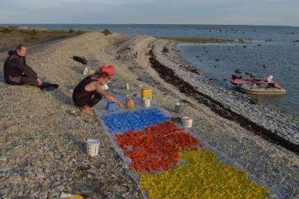
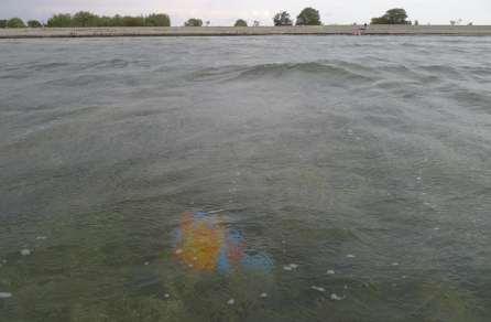

22 Painted sediment experiment Osmussaar Sept. 11


23 Influence on coasts Harilaiu Ps. Kiipsaare and Kelba Capes Kiipsaare RDCP Kelba

24 Sea level, m 3 a) 7 Nov. O 6 Dec. O Kelba spit during storm Berit (7-9. Nov. 11) 1-1 Sea level (smooth) Sea level + model wave height Days f rom km


25 Osmussaar and Neugrund - 54 mill.year old meteorite crater 7-8 km diameter, current height 5 m buried over different periods of time, re-exposed Osmussaar RDCP Neugrund RDCP Sundgrund 5


26 Natural history - after the last ice age Osmussaar emerged from the Baltic Sea about 3 years ago Ancylus Lake 8 years ago Littorina Sea 5-7 years ago The present rate of the postglacial rebound ~.7 mm/year 6
27 Sea level (cm) Sea level (cm) Sea level (cm) Tide gauge data : annual means annual max a Paldiski (.6) 1 d Paldiski Local mean sea levels still slightly decrease because the uplift mm/yr is a bit faster than the global sea level rise (1.9 mm/yr in , but probably 3 mm/yr in last 1 years) Rohuküla (.4) b Rohuküla e However, trends in annual max sea levels significantly increase: more storms and coastal erosion Ristna (.6) c Ristna f

 fetches")

28 Exposed W and N coasts: coastal erosion Cliff recedes ~9 cm/year The lighthouse several times rebuilt (1765, 185, 1954) fetches for waves are longer SW-W-NW: direction for prevailing winds and storms 1954, 35m high 8


29 The eroded sediment (gravel, pebble) moves alongshore, southward, especially during storms Beach ridges (up to -3m high) and spits are formed; new land Osmussaar as a whole slowly migrates to SE 9


")
30 Coastal developments at the two southern study sites Coastline on the SW and S parts is migrating seaward by formation of accumulative beach ridges and spits of gravel, pebble and sand. The accumulative spit (in OS) has grown about 8 m since 19; a previous bay (Inahamne) became a lake in ~1935
Wave climate and coastal processes in the Osmussaar Neugrund region, Baltic Sea
 Coastal Processes II 99 Wave climate and coastal processes in the Osmussaar Neugrund region, Baltic Sea Ü. Suursaar 1, R. Szava-Kovats 2 & H. Tõnisson 3 1 Estonian Marine Institute, University of Tartu,
Ü. Suursaar & T. Kullas Estonian Marine Institute, University of Tartu, Estonia. Abstract. 1 Introduction
 Coastal Processes 15 Decadal changes in wave climate and sea level regime: the main causes of the recent intensification of coastal geomorphic processes along the coasts of Western Estonia? Ü. Suursaar
Observation and analysis of coastal changes in the West Estonian Archipelago caused by storm Ulli (Emil) in January 2012
 in January 2012") bservation and analysis of coastal changes in the West Estonian Archipelago caused by storm Ulli 1 bservation and analysis of coastal changes in the West Estonian Archipelago caused by storm Ulli (Emil)
bservation and analysis of coastal changes in the West Estonian Archipelago caused by storm Ulli 1 bservation and analysis of coastal changes in the West Estonian Archipelago caused by storm Ulli (Emil)
Modelling of flows, sea level variations and bottom stresses in the coastal zone of West Estonia
 Modelling of flows, sea level variations and bottom stresses in the coastal zone of West Estonia U. Suursaar, T. Kullas, & M. Otsmann Estonian Marine Institute, University of Tartu, Estonia Abstract Flow
Chapter 10 Lecture Outline. The Restless Oceans
 Chapter 10 Lecture Outline The Restless Oceans Focus Question 10.1 How does the Coriolis effect influence ocean currents? The Ocean s Surface Circulation Ocean currents Masses of water that flow from one
Australian Coastal Councils Conference
 Australian Coastal Councils Conference Kiama March 2019 Where Has My Beach Gone? (and what can I do about it?) Dr Andrew McCowan Water Technology Where Has My Beach Gone? Where Has My Beach Gone? Where
Reading Material. Inshore oceanography, Anikouchine and Sternberg The World Ocean, Prentice-Hall
 Reading Material Inshore oceanography, Anikouchine and Sternberg The World Ocean, Prentice-Hall BEACH PROCESSES AND COASTAL ENVIRONMENTS COASTAL FEATURES Cross section Map view Terminology for Coastal
4/20/17. #30 - Coastlines - General Principles Coastlines - Overview
 Writing Assignment Due one week from today by 11:59 pm See main class web pages for detailed instructions Essays will be submitted in Illinois Compass (instructions later) Pick one: Earthquakes, tsunamis,
Jimmy s beach preliminary results
 Jimmy s beach preliminary results LP 668979 Jimmy s Beach Restoration Society 1 Outline 1. Long term: GIS analyses. Aerial photos, charts Shoreline analyses Storm data from MHL/DECC 2. Medium term: morphologic
General Coastal Notes + Landforms! 1
 General Coastal Notes + Landforms! 1 Types of Coastlines: Type Description Primary Coast which is essentially in the same condition when sea level stabilized Coastline after the last ice age, younger.
LAKKOPETRA (GREECE) EUROSION Case Study. Contact: Kyriakos SPYROPOULOS. TRITON Consulting Engineers. 90 Pratinou Str Athens (GREECE)
 EUROSION Case Study. Contact: Kyriakos SPYROPOULOS. TRITON Consulting Engineers. 90 Pratinou Str Athens (GREECE)") LAKKOPETRA (GREECE) Contact: Kyriakos SPYROPOULOS TRITON Consulting Engineers 90 Pratinou Str. 11634 Athens (GREECE) Tel: +32 10 729 57 61 Fax: +32 10 724 33 58 e-mail: kspyropoulos@tritonsa.gr 19 1 1.
LAKKOPETRA (GREECE) Contact: Kyriakos SPYROPOULOS TRITON Consulting Engineers 90 Pratinou Str. 11634 Athens (GREECE) Tel: +32 10 729 57 61 Fax: +32 10 724 33 58 e-mail: kspyropoulos@tritonsa.gr 19 1 1.
Lecture Outlines PowerPoint. Chapter 15 Earth Science, 12e Tarbuck/Lutgens
 Lecture Outlines PowerPoint Chapter 15 Earth Science, 12e Tarbuck/Lutgens 2009 Pearson Prentice Hall This work is protected by United States copyright laws and is provided solely for the use of instructors
COASTAL ENVIRONMENTS. 454 lecture 12
 COASTAL ENVIRONMENTS Repeated movement of sediment & water constructs a beach profile reflecting the balance between average daily or seasonal wave forces and resistance of landmass to wave action Coasts
Shore - place where ocean meets land Coast - refers to the larger zone affected by the processes that occur at this boundary.
 Waves, Beaches, and Coasts Shore - place where ocean meets land Coast - refers to the larger zone affected by the processes that occur at this boundary. Waves: energy moving through water The height of
Earth Science Chapter 16 Section 3 Review
 Name: Class: Date: Earth Science Chapter 16 Section 3 Review Multiple Choice Identify the choice that best completes the statement or answers the question. 1. The movement of water that parallels the shore
Wave Generation. Chapter Wave Generation
 Chapter 5 Wave Generation 5.1 Wave Generation When a gentle breeze blows over water, the turbulent eddies in the wind field will periodically touch down on the water, causing local disturbances of the
LOCALLY CONCENTRATED SEVERE BEACH EROSION ON SEISHO COAST CAUSED BY TYPHOON T0709
 F-4 Fourth International Conference on Scour and Erosion 2008 LOCALLY CONCENTRATED SEVERE BEACH EROSION ON SEISHO COAST CAUSED BY TYPHOON T0709 Yoshimitsu TAJIMA 1 and Shinji SATO 2 1 Member of JSCE, Associate
Label the diagram below with long fetch and short fetch:
 Coastal Processes Coasts are shaped by the sea and the action of waves. The processes that take place are erosion, transportation and deposition. The power of waves is one of the most significant forces
WIND SPEED LENGTH OF TIME WIND BLOWS (Duration) DISTANCE OVER WHICH IT BLOWS (Fetch)
 DISTANCE OVER WHICH IT BLOWS (Fetch)") WAVES Up and down movement of ocean surface Transportation of energy across the water over vast distances If not stopped by anything, waves can travel entire oceans Size and speed depend upon: WIND SPEED
WAVES Up and down movement of ocean surface Transportation of energy across the water over vast distances If not stopped by anything, waves can travel entire oceans Size and speed depend upon: WIND SPEED
Shorelines Earth - Chapter 20 Stan Hatfield Southwestern Illinois College
 Shorelines Earth - Chapter 20 Stan Hatfield Southwestern Illinois College The Shoreline A Dynamic Interface The shoreline is a dynamic interface (common boundary) among air, land, and the ocean. The shoreline
Coastal Processes and Landforms
 Coastal Processes and Landforms These icons indicate that teacher s notes or useful web addresses are available in the Notes Page. This icon indicates that the slide contains activities created in Flash.
SAND BOTTOM EROSION AND CHANGES OF AN ACTIVE LAYER THICKNESS IN THE SURF ZONE OF THE NORDERNEY ISLAND
 SAND BOTTOM EROSION AND CHANGES OF AN ACTIVE LAYER THICKNESS IN THE SURF ZONE OF THE NORDERNEY ISLAND Kos'yan R. 1, Kunz H. 2, Podymov l. 3 1 Prof.Dr.,The Southern Branch of the P.P.Shirshov Institute
Unit 11 Lesson 2 How Does Ocean Water Move? Copyright Houghton Mifflin Harcourt Publishing Company
 Unit 11 Lesson 2 How Does Ocean Water Move? Catch a Wave A wave is the up-and-down movement of surface water. Catch a Wave Catch a Wave (wave effects) Surface waves are caused by wind pushing against
2016 NC Coastal Local Governments Annual Meeting
 2016 NC Coastal Local Governments Annual Meeting Coastal Flood Study Modeling and Mapping 101 April 21, 2016 Tom Langan, PE, CFM Engineering Supervisor NCEM Floodplain Mapping Program FEMA Coastal Flood
DUXBURY WAVE MODELING STUDY
 DUXBURY WAVE MODELING STUDY 2008 Status Report Duncan M. FitzGerald Peter S. Rosen Boston University Northeaster University Boston, MA 02215 Boston, MA 02115 Submitted to: DUXBURY BEACH RESERVATION November
Coasts. 1. Coastal Processes. 1.1 Coastal erosion. 1.2 Sediment transport. Coastal Processes and Landforms. i. Hydraulic action
 Coasts Coastal Processes and Landforms 1. Coastal Processes 1.1 Coastal erosion i. Hydraulic action When waves strike against a rock surface, the waves trap air in the rock joints. This air is compressed
Volume and Shoreline Changes along Pinellas County Beaches during Tropical Storm Debby
 Volume and Shoreline Changes along Pinellas County Beaches during Tropical Storm Debby Ping Wang and Tiffany M. Roberts Coastal Research Laboratory University of South Florida July 24, 2012 Introduction
Compiled by Uwe Dornbusch. Edited by Cherith Moses
 REPORT ON WAVE AND TIDE MEASUREMENTS Compiled by Uwe Dornbusch. Edited by Cherith Moses 1 Aims...1 2 Summary...1 3 Introduction...1 4 Site selection...1 5 Wave recorder settings...2 6 Results...2 6.1 Water
Natural Bridges Field Trip Activity
 Natural Bridges Field Trip Activity This is due in class on MONDAY- March 1 - not in sections! Name TA: NOTE ON THE GRADING OF THIS ASSIGNMENT: Many of the questions below (especially in the tidepool part)
EXISTING AND PLANNED STRATEGIES AND ACTIONS CONNECTED WITH COASTAL PROTECTION IN ASPECT OF PREDICTED SEA LEVEL RISE
 EXISTING AND PLANNED STRATEGIES AND ACTIONS CONNECTED WITH COASTAL PROTECTION IN ASPECT OF PREDICTED SEA LEVEL RISE Andrzej Cieślak Long term coastal protection strategy In 2000 a new 1 Polish long term
CROSS-SHORE SEDIMENT PROCESSES
 The University of the West Indies Organization of American States PROFESSIONAL DEVELOPMENT PROGRAMME: COASTAL INFRASTRUCTURE DESIGN, CONSTRUCTION AND MAINTENANCE A COURSE IN COASTAL DEFENSE SYSTEMS I CHAPTER
MESSOLOGI LAGOON AREA (GREECE)
") MESSOLOGI LAGOON AREA (GREECE) 20 Contact: Kyriakos SPYROPOULOS TRITON Consulting Engineers 90 Pratinou Str. 11634 Athens (GREECE) Tel: +32 10 729 57 61 Fax: +32 10 724 33 58 e-mail: kspyropoulos@tritonsa.gr
MESSOLOGI LAGOON AREA (GREECE) 20 Contact: Kyriakos SPYROPOULOS TRITON Consulting Engineers 90 Pratinou Str. 11634 Athens (GREECE) Tel: +32 10 729 57 61 Fax: +32 10 724 33 58 e-mail: kspyropoulos@tritonsa.gr
Inlet Management Study for Pass-A-Grille and Bunces Pass, Pinellas County, Florida
 Inlet Management Study for Pass-A-Grille and Bunces Pass, Pinellas County, Florida Final Report Submitted By Ping Wang, Ph.D., Jun Cheng Ph.D., Zachary Westfall, and Mathieu Vallee Coastal Research Laboratory
Chapter. The Dynamic Ocean
 Chapter The Dynamic Ocean An ocean current is the mass of ocean water that flows from one place to another. 16.1 The Composition of Seawater Surface Circulation Surface Currents Surface currents are movements
LITTLE LAGOON & LITTLE LAGOON PASS: RESEARCH UPDATES & DIRECTIONS
 LITTLE LAGOON & LITTLE LAGOON PASS: RESEARCH UPDATES & DIRECTIONS Bret M. Webb, PhD, PE, DCE Professor Department of Civil, Coastal, and Environmental Engineering October 19, 2017 LLPS Meeting Acknowledgments
INTRODUCTION TO COASTAL ENGINEERING
 The University of the West Indies Organization of American States PROFESSIONAL DEVELOPMENT PROGRAMME: COASTAL INFRASTRUCTURE DESIGN, CONSTRUCTION AND MAINTENANCE A COURSE IN COASTAL DEFENSE SYSTEMS I CHAPTER
INTRODUCTION TO COASTAL ENGINEERING AND MANAGEMENT
 Advanced Series on Ocean Engineering Volume 16 INTRODUCTION TO COASTAL ENGINEERING AND MANAGEMENT J. William Kamphuis Queen's University, Canada World Scientific Singapore New Jersey London Hong Kong Contents
LAB: WHERE S THE BEACH
 Name: LAB: WHERE S THE BEACH Introduction When you build a sandcastle on the beach, you don't expect it to last forever. You spread out your towel to sunbathe, but you know you can't stay in the same spot
Chapter - Oceans and Coasts
 Chapter - Oceans and Coasts Discussion: What do oceans contribute to the environment of Earth? How do Earth s major systems relate to the oceans? Oceans and Coasts Oceans are important - Thermal regulation
Coastal Change and Conflict
 Coastal Change and Conflict Outline of the Topic Contrasting Coasts why do all coasts not look the same? Geology of the coast the impact rock structure has on the coastline Waves Constructive and destructive
Influence of oceanographic processes on coastal erosion, morphology and inundation
 FACULTY OF ENGINEERING, COMPUTING AND MATHEMATICS Influence of oceanographic processes on coastal erosion, morphology and inundation Charitha Pattiaratchi School of Civil, Environmental and Mining Engineering
Figure 4, Photo mosaic taken on February 14 about an hour before sunset near low tide.
 The Impact on Great South Bay of the Breach at Old Inlet Charles N. Flagg and Roger Flood School of Marine and Atmospheric Sciences, Stony Brook University Since the last report was issued on January 31
There are many different kinds of beaches which are generally characterized by the dominance of waves, tides, rivers and currents, and in particular
 Fig. 11-11, p. 253 There are many different kinds of beaches which are generally characterized by the dominance of waves, tides, rivers and currents, and in particular differ by the amount of energy, which
TITLE: COASTAL EROSION AND LANDFORMS.
 TITLE: COASTAL EROSION AND LANDFORMS. AIM: What are the factors that influence the formation of coastal features along Fishing Pond beach Trinidad? LOCATION OF FIELD STUDY: The study was carried out in
APPENDIX G WEATHER DATA SELECTED EXTRACTS FROM ENVIRONMENTAL DATA FOR BCFS VESSEL REPLACEMENT PROGRAM DRAFT REPORT
 APPENDIX G WEATHER DATA SELECTED EXTRACTS FROM ENVIRONMENTAL DATA FOR BCFS VESSEL REPLACEMENT PROGRAM DRAFT REPORT Prepared for: B.C. Ferries Services Inc. Prepared by: George Roddan, P.Eng. Roddan Engineering
CMS Modeling of the North Coast of Puerto Rico
 CMS Modeling of the North Coast of Puerto Rico PRESENTED BY: Dr. Kelly Rankin Legault, Ph.D., P.E. 1 Dr. Alfredo Torruella, Ph.D. 2 1 USACE Jacksonville District 2 University of Puerto Rico October 2016
MONITORING SEDIMENT TRANSPORT PROCESSES AT MANAVGAT RIVER MOUTH, ANTALYA TURKEY
 COPEDEC VI, 2003 in Colombo, Sri Lanka MONITORING SEDIMENT TRANSPORT PROCESSES AT MANAVGAT RIVER MOUTH, ANTALYA TURKEY Isikhan GULER 1, Aysen ERGIN 2, Ahmet Cevdet YALCINER 3 ABSTRACT Manavgat River, where
HARBOUR SEDIMENTATION - COMPARISON WITH MODEL
 HARBOUR SEDIMENTATION - COMPARISON WITH MODEL ABSTRACT A mobile-bed model study of Pointe Sapin Harbour, in the Gulf of St. Lawrence, resulted in construction of a detached breakwater and sand trap to
Boothbay Harbor Rotary Club May 12, 2016
 Mapping Potential Sea Level Rise and Storm Surge in Boothbay Harbor, ME Boothbay Harbor Rotary Club May 12, 2016 Peter A. Slovinsky, Marine Geologist Maine Geological Survey S.M. Dickson, MGS Quickly,
Chapter 20 Lecture. Earth: An Introduction to Physical Geology. Eleventh Edition. Shorelines. Tarbuck and Lutgens Pearson Education, Inc.
 Chapter 20 Lecture Earth: An Introduction to Physical Geology Eleventh Edition Shorelines Tarbuck and Lutgens The Shoreline: A Dynamic Interface The Coastal Zone The shoreline is constantly modified by
Oceans and Coasts. Chapter 18
 Oceans and Coasts Chapter 18 Exploring the oceans The ocean floor Sediments thicken and the age of the seafloor increases from ridge to shore The continental shelf off the northeast United States Constituent
CALCASIEU SALINITY STRUCTURES. HYDRODYNAMIC MODELING (To Support Design of Salinity Barriers)
") CALCASIEU SALINITY STRUCTURES HYDRODYNAMIC MODELING (To Support Design of Salinity Barriers) Presentation Overview 1 2 3 4 5 Project Overview and CEA Circulation Modeling Vessel Hydrodynamics Modeling
CALCASIEU SALINITY STRUCTURES HYDRODYNAMIC MODELING (To Support Design of Salinity Barriers) Presentation Overview 1 2 3 4 5 Project Overview and CEA Circulation Modeling Vessel Hydrodynamics Modeling
Q1. What are the primary causes/contributors to coastal erosion at Westshore and the concept of longshore / littoral drift.
 Q1. What are the primary causes/contributors to coastal erosion at Westshore and the concept of longshore / littoral drift. In order of (timing related) contribution to present problem 1. Beach is too
Wave-dominated embayed beaches. Andrew D Short School of Geosciences University of Sydney
 Wave-dominated embayed beaches Andrew D Short School of Geosciences University of Sydney Wave-dominated embayed beaches wave-dominated beaches embayed beaches morphodynamics of W-D embayed beaches circulation,
1 Shoreline Erosion and Deposition
 CHAPTER 12 1 Shoreline Erosion and Deposition SECTION Agents of Erosion and Deposition BEFORE YOU READ After you read this section, you should be able to answer these questions: What is a shoreline? How
Impact of Dredging the Lower Narrow River on Circulation and Flushing
 Impact of Dredging the Lower Narrow River on Circulation and Flushing Craig Swanson Ph.D. Swanson Environmental Alex Shaw Ocean Engineering, URI Prof. Malcolm L. Spaulding Ocean Engineering, URI 29 January
Legal, scientific and engineering aspects of Integrated Coastal Zone Management (ICZM) in Poland
 in Poland") Gdańsk, March 21 st 2013 Legal, scientific and engineering aspects of Integrated Coastal Zone Management (ICZM) in Poland Rafał Ostrowski Institute of Hydro-Engineering of the Polish Academy of Sciences
Gdańsk, March 21 st 2013 Legal, scientific and engineering aspects of Integrated Coastal Zone Management (ICZM) in Poland Rafał Ostrowski Institute of Hydro-Engineering of the Polish Academy of Sciences
Directed Reading. Section: Ocean Currents. a(n). FACTORS THAT AFFECT SURFACE CURRENTS
. FACTORS THAT AFFECT SURFACE CURRENTS") Skills Worksheet Directed Reading Section: Ocean Currents 1. A horizontal movement of water in a well-defined pattern is called a(n). 2. What are two ways that oceanographers identify ocean currents? 3.
Skills Worksheet Directed Reading Section: Ocean Currents 1. A horizontal movement of water in a well-defined pattern is called a(n). 2. What are two ways that oceanographers identify ocean currents? 3.
Sea-Level Rise and Coastal Habitats in Southeastern Louisiana An Application of the SLAMM Model
 Sea-Level Rise and Coastal Habitats in Southeastern Louisiana An Application of the SLAMM Model Patty Glick (National Wildlife Federation) Jonathan Clough (Warren Pinnacle Consulting, Inc.) Amy Polaczyk
Essentials of Oceanography Eleventh Edition
 Chapter Chapter 1 10 Clickers Lecture Essentials of Oceanography Eleventh Edition The Coast: Beaches and Shoreline Processes Alan P. Trujillo Harold V. Thurman Chapter Overview Coastal regions have distinct
Waves Part II. non-dispersive (C g =C)
") Waves Part II Previously we discussed Surface Gravity Waves Deep Water Waves Shallow Water Waves C g T 2 C g h dispersive (C g =C/2) Definitions: phase speed C= /T= /k non-dispersive (C g =C) group speed
Waves Part II Previously we discussed Surface Gravity Waves Deep Water Waves Shallow Water Waves C g T 2 C g h dispersive (C g =C/2) Definitions: phase speed C= /T= /k non-dispersive (C g =C) group speed
Tidal regime along Vietnam coast under impacts of sea level rise
 VNU Journal of Science, Earth Sciences 28 (2012) 133-139 Tidal regime along Vietnam coast under impacts of sea level rise Tran Thuc, Duong Hong Son* Vietnam Institute of Meteorology, Hydrology and Environment
What are we adapting to? David Provis Senior Principal, Oceanography, Cardno Member, Victorian Coastal Council
 What are we adapting to? David Provis Senior Principal, Oceanography, Cardno Member, Victorian Coastal Council Sea-level -NOAA Sea-level - NOAA 90% probability ranges Sea-level - NOAA Sea-level Port Phillip
1.5 How do ocean waves and currents change the face of coastal areas? (Chapter 3)
") 1.5 How do ocean waves and currents change the face of coastal areas? (Chapter 3) 1. Hydraulic Action/Pressure - air being forced into crack in rocks. 2. Corrosion (Solution) Minerals such as calcium carbonate
1.5 How do ocean waves and currents change the face of coastal areas? (Chapter 3) 1. Hydraulic Action/Pressure - air being forced into crack in rocks. 2. Corrosion (Solution) Minerals such as calcium carbonate
Today: Coastal Issues and Estuaries
 Today: Coastal Issues and Estuaries Coastal issues Human effect on coastlines What is an estuary Why are they so important? Circulation of water in estuary Environmental issues Coastal Issues: Problem
Deep-water orbital waves
 What happens when waves approach shore? Deep-water orbital waves Fig. 9.16, p. 211 Wave motion is influenced by water depth and shape of the shoreline wave buildup zone surf zone beach Wave base deepwater
Future Condi,ons coastal hazard modeling and mapping
 Future Condi,ons coastal hazard modeling and mapping Presented by Bob Ba:alio, PE Environmental Science Associates, Inc. (ESA) On behalf of the physical processes team (USGS, TerraCosta- Scripps, ESA)
Long Beach Island Holgate Spit Little Egg Inlet Historical Evolution Introduction Longshore Transport Map, Survey and Photo Historic Sequence
 Appendix B Long Beach Island Holgate Spit Little Egg Inlet Historical Evolution Introduction The undeveloped southern end of Long Beach Island (LBI) is referred to as the Holgate spit as it adjoins the
Overview. Beach Features. Coastal Regions. Other Beach Profile Features. CHAPTER 10 The Coast: Beaches and Shoreline Processes.
 Overview CHAPTER 10 The Coast: Beaches and Shoreline Processes Coastal regions constantly change. The beach is a dominant coastal feature. Wave activity continually modifies the beach and coastal areas.
Variation in Beach Profile and Sediment Characteristics at Popham Beach, Phippsburg, ME
 Colby College Digital Commons @ Colby Undergraduate Research Symposium Student Research 2006 Variation in Beach Profile and Sediment Characteristics at Popham Beach, Phippsburg, ME Kathryn Lidington Colby
Town of Duck, North Carolina
 Tracking No. 00.00.2010 Erosion Mitigation And Shoreline Management Feasibility Study Town of Duck, North Carolina Coastal Planning & Engineering of North Carolina August 15, 2012 Tom Jarrett Robert Neal
STABLE DYNAMIC BEACH MODELLING FRAMEWORK
 GEOMORPHIC SOLUTIONS 141 Brunel Road Mississauga, ON L4Z 1X3 T 416 213 7121 F 95 89 8499 www.geomorphicsolutions.ca STABLE DYNAMIC BEACH MODELLING FRAMEWORK Geomorphic & Environmental Sciences Hazard Land
Observed and simulated wavetide interaction in a region of. high tidal flow
 Observed and simulated wavetide interaction in a region of high tidal flow Lewis M*; Chang W; Neill S; Robins P; Hashemi R;Ward S; Piano M * m.j.lewis@bangor.ac.uk (1/12) Summary Dynamically coupled wave-tide
The Composition of Seawater
 The Composition of Seawater Salinity Salinity is the total amount of solid material dissolved in water. Most of the salt in seawater is sodium chloride, common table salt. Element Percent Element Percent
Table 4. Volumetric Change Rates Pre-Project and Post-Project for the Town of Duck
 V. VOLUMETRIC CHANGES General Volumetric changes measured over the entire monitoring area for various time periods are provided in Table 4. The volume changes are given in terms of cubic yards/foot of
Marginal Marine Environments
 Marginal Marine Environments Delta: discrete shoreline protuberances formed where rivers enter oceans, semi-enclosed seas, lakes or lagoons and supply sediment more rapidly than it can be redistributed
Chesil Beach, Dorset UK High energy, shingle coastline. Brighton Beach, Sussex UK Pebble beach
 Beaches: Depositional landform Extends from the highest high tide to the lowest low tide. Very important temporary store in coastal system. Accretion: sediment returning to the visible portion of a beach
On the role of Posidonia oceanica on Mediterranean beaches
 Water Wave Mechanics and Coastal Engineering Imposición Medalla como Académico Correspondiente de la RAI al Prof. R.A. Dalrymple On the role of Posidonia oceanica on Mediterranean beaches Lluís GÓMEZ-PUJOL
Managing and Adapting to Sea Level Rise in Egypt. Coastal Research Institute
 Managing and Adapting to Sea Level Rise in Egypt Coastal Research Institute Global Perspective Climate-induced increases in sea level are caused by thermal expansion of the oceans and melting of land ice
SORTING AND SELECTIVE MOVEMENT OF SEDIMENT ON COAST WITH STEEP SLOPE- MASUREMENTS AND PREDICTION
 SORTING AND SELECTIVE MOVEMENT OF SEDIMENT ON COAST WITH STEEP SLOPE- MASUREMENTS AND PREDICTION Toshiro San-nami 1, Takaaki Uda 2, Masumi Serizawa 1 and Toshinori Ishikawa 2 Conveyer belts carrying gravel
The Sea Geography Notes JC-Learn. JC-Learn. Geography Notes The Sea. 1 P a g e
 JC-Learn Geography Notes The Sea 1 P a g e The Sea *Here, you can choose to study the chapter on glaciation or the one on the sea, or even both, because whenever these topics come up in the Junior Cert
Currents measurements in the coast of Montevideo, Uruguay
 Currents measurements in the coast of Montevideo, Uruguay M. Fossati, D. Bellón, E. Lorenzo & I. Piedra-Cueva Fluid Mechanics and Environmental Engineering Institute (IMFIA), School of Engineering, Research
THE WAVE CLIMATE IN THE BELGIAN COASTAL ZONE
 THE WAVE CLIMATE IN THE BELGIAN COASTAL ZONE Toon Verwaest, Flanders Hydraulics Research, toon.verwaest@mow.vlaanderen.be Sarah Doorme, IMDC, sarah.doorme@imdc.be Kristof Verelst, Flanders Hydraulics Research,
The impact of ocean bottom morphology on the modelling of long gravity waves from tides and tsunami to climate
 The impact of ocean bottom morphology on the modelling of long gravity waves from tides and tsunami to climate Christian Le Provost and Florent Lyard Laboratoire d Etudes en Géophysique et Océanographie
BEACH PROCESSES AND COASTAL ENVIRONMENTS
 BEACH PROCESSES AND COASTAL ENVIRONMENTS COASTAL FEATURES Cross section Map view TOPICS: Terminology Waves Beach Morphology Barriers Coastal Migration Tides Tidal Flats and Marshes Sediment Budgets Human
Technical Brief - Wave Uprush Analysis 129 South Street, Gananoque
 Technical Brief - Wave Uprush Analysis 129 South Street, Gananoque RIGGS ENGINEERING LTD. 1240 Commissioners Road West Suite 205 London, Ontario N6K 1C7 June 12, 2013 Table of Contents Section Page Table
City of Del Mar Local Coastal Plan (LCP) Amendment for Sea Level Rise and Coastal Flooding
 Amendment for Sea Level Rise and Coastal Flooding") City of Del Mar Local Coastal Plan (LCP) Amendment for Sea Level Rise and Coastal Flooding 6/22/17 Presentation to Sea Level Rise Stakeholder- Technical Advisory Committee (STAC) Nick Garrity, P.E. Lindsey
City of Del Mar Local Coastal Plan (LCP) Amendment for Sea Level Rise and Coastal Flooding 6/22/17 Presentation to Sea Level Rise Stakeholder- Technical Advisory Committee (STAC) Nick Garrity, P.E. Lindsey
Exploring the Wind and Wave Climate in the Great Lakes
 Exploring the Wind and Wave Climate in the Great Lakes R.E. Jensen USACE ERDC Coastal and Hydraulics Laboratory 14 th Waves Workshop 8-13 November 2015 Key West, FL Setting / Motivation North America US:
Appendix E Cat Island Borrow Area Analysis
 Appendix E Cat Island Borrow Area Analysis ERDC/CHL Letter Report 1 Cat Island Borrow Area Analysis Multiple borrow area configurations were considered for Cat Island restoration. Borrow area CI1 is located
A Summary of the 2017 State of Maine s Beaches Report
 Maine Geologic Facts and Localities July, 2017 A Summary of the 2017 State of Maine s Beaches Report William Van Benthuysen, Kennebunkport, Maine Text by Peter A. Slovinsky, Department of Agriculture,
Exemplar for Internal Assessment Resource Geography Level 3. Resource title: The Coastal Environment Kaikoura
 Exemplar for internal assessment resource Geography 3.5A for Achievement Standard 91430 Exemplar for Internal Assessment Resource Geography Level 3 Resource title: The Coastal Environment Kaikoura This
Ocean Waves. Capillary. Gravity. Wind generated. Tides Tsunamis Seiches
 Ocean Waves Capillary Wind generated Gravity Tides Tsunamis Seiches Capillary waves are driven by the surface tension produced by electrically polarized water molecule San Pedro Lighthouse Waves are alternate
Model Test Setup and Program for Experimental Estimation of Surface Loads of the SSG Kvitsøy Pilot Plant from Extreme Wave Conditions
 Model Test Setup and Program for Experimental Estimation of Surface Loads of the SSG Kvitsøy Pilot Plant from Extreme Wave Conditions according to Co-operation Agreement (phase 4) between WAVEenergy (Norway)
Define the key terms: - Abrasion - Attrition - Hydraulic action - Solution. Y11 Coasts
 Define the key terms: - Abrasion - Attrition - Hydraulic action - Solution Abrasion caused by waves picking up material which is forced against the cliff face wearing it away Attrition where stones and
STATUS REPORT FOR THE SUBMERGED REEF BALL TM ARTIFICIAL REEF SUBMERGED BREAKWATER BEACH STABILIZATION PROJECT FOR THE GRAND CAYMAN MARRIOTT HOTEL
 August 23 STATUS REPORT FOR THE SUBMERGED REEF BALL TM ARTIFICIAL REEF SUBMERGED BREAKWATER BEACH STABILIZATION PROJECT FOR THE GRAND CAYMAN MARRIOTT HOTEL performed by Lee E. Harris, Ph.D., P.E. Consulting
Southern California Beach Processes Study
 Southern California Beach Processes Study Torrey Pines Field Site 5th Quarterly Report 31 May 22 to California Resources Agency and California Department of Boating and Waterways R.T. Guza 1, W.C. O Reilly
Coastal Inundation. An Overview for TCDC
 Coastal Inundation An Overview for TCDC Rick Liefting Team Leader Regional Hazards and Environmental Compliance Integrated Catchment Management Waikato Regional Council Photo: Sugar Loaf Wharf, Coromandel.
Cross-shore sediment transports on a cut profile for large scale land reclamations
 Cross-shore sediment transports on a cut profile for large scale land reclamations Martijn Onderwater 1 Dano Roelvink Jan van de Graaff 3 Abstract When building a large scale land reclamation, the safest
TITLE: North Carolina s Changing Shorelines. KEYWORDS: erosion - shorelines - mapping - sustainability
 UNC Coastal Studies Institute Teacher Resources 1 TITLE: North Carolina s Changing Shorelines KEYWORDS: erosion - shorelines - mapping - sustainability Changing shorelines impact coastal infrastructure.
Announcements. Explosions at the Fukushima nuclear power plant, Japan. Next project due online Nov. 6th A week of waves
 Announcements Next project due online Nov. 6th A week of waves Today: Gravity waves Thursday: Tidal waves Figure from Science, 3 September, 005 Explosions at the Fukushima nuclear power plant, Japan 0