PB Sports & Entertainment
|
|
|
- Dwayne Allen
- 5 years ago
- Views:
Transcription

1 BAYLOR UNIVERSITY New Stadium Community Meeting/Public Comment
2 Agenda Introductions Goals of Meeting Stadium TMP Overview Neighborhood Options & Opportunities Q&A


3 Sample Projects Colorado State Univ Hughes Stadium Northwestern University Site Assessment Baylor University Site Selection Vanderbilt University Parking Master Plan Univ of Louisville Papa Johns Stadium Ohio State MP - Value City Arena Univ of Minnesota New Stadium Super Bowl XL Detroit Dallas Cowboys 2009 New Stadium Vikings Site Selection Gillette Stadium NE Patriots Dolphin Stadium - Super Bowl MP Seattle Seahawks Qwest Field New Orleans Saints New Stadium Pittsburgh Steelers Heinz Field Cincinnati Bengals - Paul Brown Stadium Truman Center Chiefs and Royals Cleveland Browns Browns Stadium Univ of Pittsburgh - Heinz Field Pitts, PA Harvard Univ. - Allston Campus MP Montclair St. University MP, New Jersey: Ohio State Parking Garage Assessment Westfield St. Field House, Westfield, MA MIT Construction Mitigation Services MLB Site Selection Study Cincinnati Reds Great America Ballpark New Jersey Nets - New Arena Cleveland Indians Jacob s Field Pittsburgh Pirates PNC Park Seattle Mariners Safeco Park Oakland A s New Ballpark Washington Nationals Transportation Daytona 500 new MP 2014 Tampa Bay Bucs Transportation MP USTA US Open Tennis Tournament
4 Goals of Meeting Overview of Baylor University s Transportation ti Management Plan (TMP) Discuss Options and Opportunities Related to Neighborhood Impacts Obtain Feedback/Initial Comments on Community Concerns *This meeting is part of a series of meetings that will be held by the City of Waco. It is expected to be a continuous forum for comments and no final decisions are expected to come out of tonight s meeting
5 What is a Transportation Management Plan (TMP)? Manage the Transportation System Minimize i i Traffic Congestion Eliminate the unwarranted Hunt and Peck looking for Parking Pre-Sell Parking - Predetermine where parking is located Determine Traffic Routing Maps to Parking Locations Parking Locations and Travel Routes to Campus Parking Locations and Travel Routes to Downtown Waco Shuttle Routes Bicycle Routes Motor Bicycles Pedestrian Walk Paths Locations for Police at Intersections for Traffic Movement Locations for Police at Crossings for Pedestrian Safety Emergency Response Routes Retime the Traffic Signals Local Street Improvements Interstate Highway Improvements
6 What are the Benefits of a Successful TMP? Protect Neighborhoods from Negative Impacts Provide Emergency Response Minimize Traffic Congestion Manage Parking Improve Travel Experience of Fans Provides Opportunities for Economic Development
7 What is the Process? Collaboration City of Waco Adjoining Neighborhoods TxDOT Waco Metropolitan Planning Org. Downtown Development Corp. (DDC) Private Businesses Economic Development Baylor University it


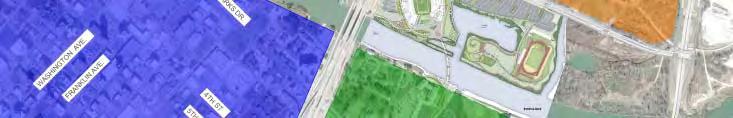


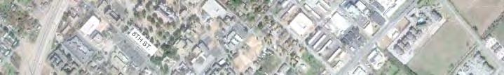
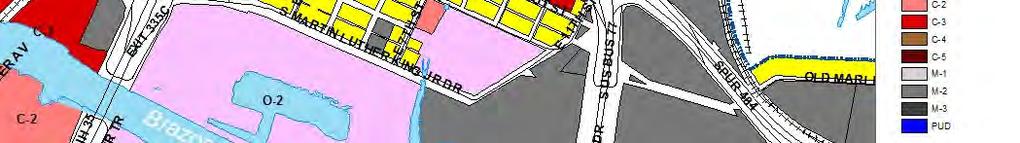
8 Local Context Baylor University Downtown Waco Olive Heights


9 Many Options for Arrival! Drive Walk Campus Downtown Hotels Bike Shuttle Bus Downtown Campus Charter Bus Potential for Water Shuttles/Taxis
10 Baylor Stadium Parking Demand New Stadium Capacity- 45,000 Seats Estimated Modal Split Student Attendees 7,000 (80% Walk, 20% Drive) = 5,600 Walk Transit Shuttles = 2,000 Riders Vehicular Demand- 37,400 Patrons Vehicle Occupancy- 3.2 Persons/Vehicle Parking Demand- 11,700 Vehicles


11 Potential Event Parking Including cud gca Campus pusa and City Public and Private Parking On-Campus = 11,000 City of Waco = 12,085* Stadium Site = 2,668 N of MLK unknown TOTAL = 25,753 *2008 Waco Downtown Parking Study (Public and Private)
12 Parking Supply Vs Demand? Potential Supply = 25,753 Spaces Parking Demand = 11,700 Vehicles Parking Supply Exceeds Demand Next Steps is Study on Availability
13 Campus & Downtown Parking
14 Potential Event Parking? Potential Campus and City Patron Parking in 25-Minute Walk 9,523- Campus 2,668 - On-Site 1,059- Downtown (Public)? - Downtown (Private)? - N of MLK 13,250 TOTAL Supply Still Exceeds Demand!
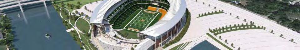
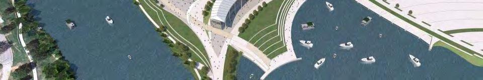
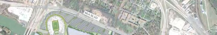
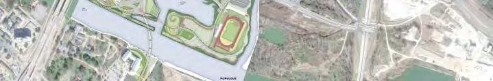
15 Baylor Stadium Site Plan Driveway Entrances to Pre-Sold Parking Pedestrian Bridge Baylor Basin Grass Tailgate RV Parking Grass Parking


16 Campus Parking Supply 11,000 Total Parking Spaces on Campus Students d t Faculty Visitor Disabled Dean Maintenance Dining


17 Campus Gameday Parking Law School Ferrell Center Robinson Tower Dutton Garage Speight Garage Assume 90% of Lot Capacity Available for Gameday Total for Game 7,290 On Campus Parking Spaces


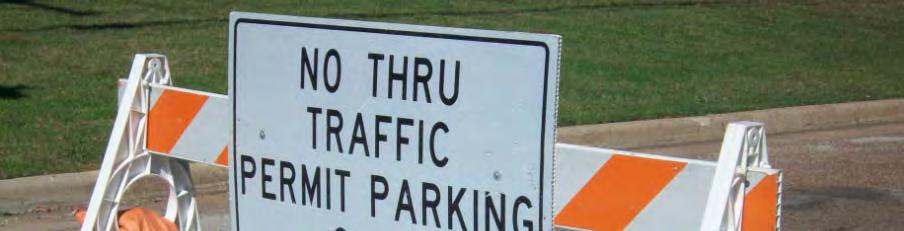
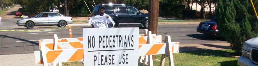
18 Limit Campus Access Close off Campus at 14 Locations Access Control at Key Locations to Allow Entry to Gameday Permitted Faculty & Staff Control All Locations with Police and/or ROTC & moveable barricades


19 Reversible Lanes and Other Restrictions Limited Access onto Campus for Permitted Vehicles and Shuttles MLK Reversible Lanes

 Ferrell")


20 Campus Shuttles- Ingress 2 Point-To To- Point Routes on Campus 1) Ferrell Center 2) Speight Garage 3 rd St. Access to Existing Stop on Speight Ave Law School U-Turn with On-Street Pick- Up for Ferrell Center


21 Campus Shuttles- Egress Single Loop with Drop- Off at Ferrell Center and Speight Garage Law School Single Loop with Drop-Off at Ferrell & Speight


22 Bicycle & Motorized Scooter Parking x No Motorized Scooters or Bicycles allowed on Pedestrian Bridge


23 Arrival Pedestrian Flow From Campus From City Recommendations to Improve Pedestrian Flows: Extend Riverwalk on North Side of River (State Grant Approved)
24 Downtown Parking Supply & Demand Downtown Demand Total Demand- 11,700 On-Site 2,668 On-Campus 7,290 Remaining Demand approx. 1,742 Spaces 2008 Waco Downtown Parking Supply Public City Other Public Private Parking TOTAL 12,085 5,650 (On & Off Street)? (Other Public Agencies)? (Hotels & Businesses)


25 Downtown Hotels Courtyard Marriott Hilton Residence Inn Hotel Indigo America s Best Clarion Inn La Quinta Victorian Inn Scottish Inn Approx. 850 Spaces


 Downtown On-Street")
 Downtown Lots-")
26 Downtown Public Parking Public Lots Approx 1,059 Identified in Downtown within 25 Minute Walk On-Street Parking (?) Downtown On-Street Spaces (?) Downtown Lots Spaces Private Lots Private Parking (?)
")


27 Downtown Shuttle(s) Program Postgame Events at Stadium/ Riverfront to Spread Out Arrival at Shuttle Univ. Parks Drive Shuttle Route Heritage Sq. Pick-Up & Drop-Off


28 Event Staff Parking Event Staff Parking 500 Event Staff Spaces


29 Emergency Vehicle Access
30 Event Routing Due to I-35 Construction ti Under Study


31 Where are Patrons Coming From? Heavy Concentration of Ticket Sales in Waco, Dallas, Austin I-35 and Hwy 6 are Primary Access Routes


32 Regional Distribution (2011) Access Route % Arrival I-35 NB 20% I-35 SB 31% Hwy 6 EB 23% Hwy 77 NB 20% Hwy 84 EB 4% Hwy 6/164 WB 1% Hwy 31 SB 1%


33 Regional Access I-35: 6 Interchanges Year 1 under review due to construction. Hwy 77: 3 Interchanges Loop 340:2 Interchanges TOTAL- 11 Interchange Options


34 Arrival & Departure Traffic Model Update Based on Ticket Sales- Estimates on Numbers/Locations from Athletics


35 Arrival Traffic Volumes Evaluate Traffic Volumes and Identify Routes that are Over Capacity Retime Traffic Signals Identify Locations for Police, Traffic and Pedestrian Control


36 Wayfinding Signage


37 Arrival VMS Signage 13 Arrival Sign Locations Ongoing Coordination with TxDOT on Sign Location and Messages


38 Arrival Gameday Parking Signage 13 Arrival Sign Locations Sign Design and Messages Ongoing


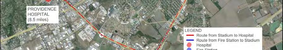
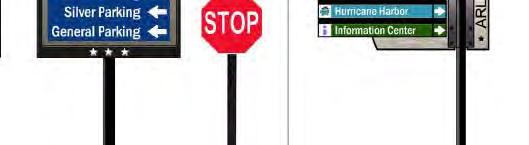
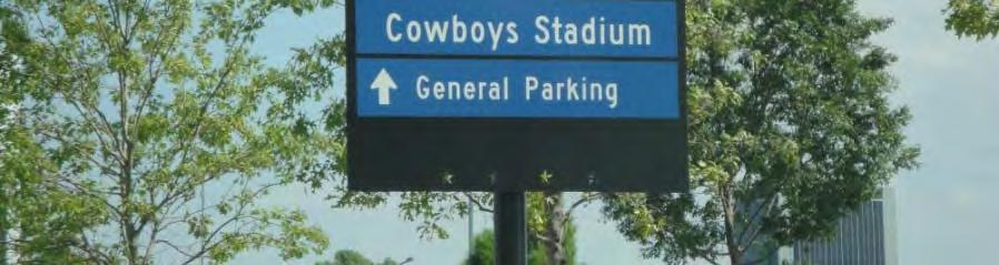
39 Parking Signage Sample Signage Plan from Dallas Cowboys TMP


40 Restrictive Signage Sample Signage Plan from Dallas Cowboys TMP


41 Egress VMS Signage 4 Egress Sign Locations Need to be rotated and/or relocated from arrival positions
42 Intersection Staffing and Operations Plans Sample Ops Plan from Dallas Cowboys TMP
43 Public Safety Coordination


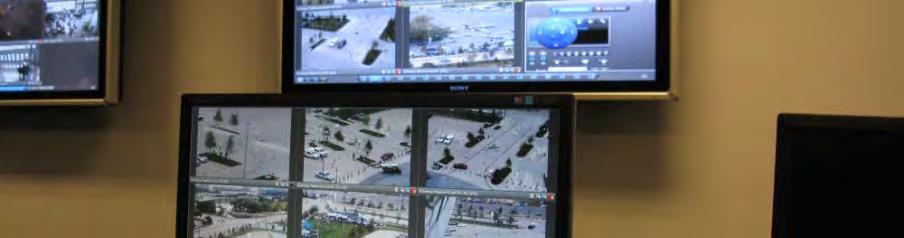
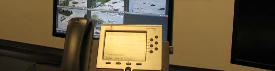
44 Public Safety Control Center
45 Olive Heights Neighborhood
46 Clint Peters, City of Waco tx


47 Olive Heights Olive Heights Community Process Ongoing Discussion with City of Waco after TMP Overview
48 Neighborhood Collaboration Neighborhood Collaboration Protect Neighborhood from Negative Impacts Minimize/eliminate unwarranted trespass parking in neighborhoods Minimize/eliminate uninvited traffic looking for a place to park Neighborhood Outreach Listen Learn Identify the Issues Establish the Neighborhood Zone Ongoing community engagement on a periodic basis after the new stadium is opened Common Issues Additional traffic congestion, speeding traffic, child safety On-street parking that prevents residents from being able to park near their homes Parking that encroaches on private lawns Parking in ways that block driveways Parking that reduces residential street access Parking and traffic that impacts emergency vehicles

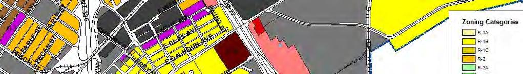
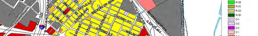
49 Zoning Restrictions
50 Neighborhood Parking Options Existing Residential Zoning Restricts Parking on Lawns and in Vacant Parcels Some Parking Plan Options Allow or Eliminate Parking? Establishing a System of Residential Parking Permits or Stickers Providing Permits for Visitors Updating Zoning Laws for Parking in Residential Zones Precluding Sale of Parking in Residential Zone Providing Parking Signage

51
52 Neighborhood Comments/Ideas What would you like to see for Your Neighborhood? Please Provide Your Name and Where You Live Limit Comments to 2-Minutes or Less Write Comment Sheets are Provided for Further Comments in Writing Next Meeting Early Fall!
Presentation to Media. February 27, 2008
 Anacostia Waterfront Nationals Ballpark Transportation Management Plan Presentation to Media February 27, 2008 Overarching Goals of DDOT s Ballpark TMP Organize and manage traffic to ensure pedestrian
Set of plans containing details for game day operations of the Ballpark. Plans set forth the responsibilities and the specific actions of:
 What is the TOPP? Set of plans containing details for game day operations of the Ballpark. Plans set forth the responsibilities and the specific actions of: Ballpark management, District Department of
CONCERNS / CHALLENGES
 CONCERNS / CHALLENGES Time frame Transit Pedestrian Access & Comfort Bicycle Access & Comfort Neighborhood Spillover Public Info & Signange Connection to Downtown Physical Contraints of site 0-5 years
RIVERSIDE, Newton MA BH NORMANDY RIVERSIDE LLC. Riverside Station. A green, transit-oriented community
 Riverside Station A green, transit-oriented community October 6, 2011 TONIGHT S AGENDA: 1. Project Update (5 min.) 2. Master Plan Update (10 min.) 3.Traffic Plan Update (10 min.) Questions & Answers MASTER
Roads and Vehicular Traffic Design Principles. Roads and Vehicular Traffic Recommendations
 CIRCULATION AND PARKING roads and vehicular traffic The Campus Master Plan updates the campus transportation network through a multi-modal approach that encourages walking and biking while improving vehicular
TRANSPORTATION MANAGEMENT PLAN MAY 2018 DRAFT
 TRANSPORTATION MANAGEMENT PLAN MAY 2018 DRAFT TABLE OF CONTENTS Introduction... 1 History/Context... 4 Performance Goals... 6 TMP Framework... 7 Transit... 8 Pedestrian...10 Bicycle...12 General Purpose
Bellevue Downtown Association Downtown Bike Series
 Bellevue Downtown Association Downtown Bike Series Meeting 2 Franz Loewenherz Andreas Piller Kyle Potuzak Chris Long October 26, 2017 Today s Agenda: 1) Meeting Purpose 2) 9/28 Meeting Recap 3) Candidate
PLAN FOR ARENA OPERATIONS. City Council May 24, 2016
 PLAN FOR ARENA OPERATIONS City Council May 24, 2016 PROJECT OVERVIEW GOLDEN 1 CENTER OPERATIONS PROJECT SITE PLAN PROJECT SCHEDULE GOLDEN 1 CENTER OPERATIONS GOLDEN 1 CENTER AND DOCO SCHEDULE FULL ENCLOSURE
Waco Downtown Transportation Study
 Waco Downtown Transportation Study Technical Memorandum 1 Prepared for: City of Waco Public Open House Michael Townes Vice President, Transit Market Leader CDM Smith April 10, 2014 Agenda Introduction
Solana Beach Comprehensive Active Transportation Strategy (CATS)
") Solana Beach Comprehensive Active Transportation Strategy (CATS) 3.0 Goals & Policies The Solana Beach CATS goals and objectives outlined below were largely drawn from the Solana Beach Circulation Element
Solana Beach Comprehensive Active Transportation Strategy (CATS) 3.0 Goals & Policies The Solana Beach CATS goals and objectives outlined below were largely drawn from the Solana Beach Circulation Element
Baylor University Spirit Program 2017 Visiting Spirit Squads Guide MCLANE STADIUM
 Baylor University Spirit Program 2017 Visiting Spirit Squads Guide MCLANE STADIUM We look forward to your visit to Baylor University. This information will help to prepare you and your squad(s) for a successful
Kyle Field Transportation Plan. Tim Lomax, Texas A&M Transportation Institute
 Kyle Field Transportation Plan Tim Lomax, Texas A&M Transportation Institute gamedaytraffic@tamu.edu The Kyle Field Challenge 2013 82,500 Seats 5,000 to 10,000 extra tailgaters but, 30,000 to 40,000 for
PROJECT OVERVIEW. Auburn Station Access Improvements Project
 ROJECT OVERVIEW Auburn Station Access Improvements roject Average daily ridership on the south Sounder line has been growing rapidly over the past few years and is expected to increase approximately 70
I-90 ALLSTON INTERCHANGE A MULTIMODAL TRANSPORTATION PROJECT MEPA CONSULTATION MEETING NOVEMBER 20, 2014 BRIGHTON HIGH SCHOOL
 I-90 ALLSTON INTERCHANGE A MULTIMODAL TRANSPORTATION PROJECT MEPA CONSULTATION MEETING NOVEMBER 20, 2014 BRIGHTON HIGH SCHOOL Today s Agenda 1. 2. 3. 4. 5. Overview of the MEPA Process Project Overview
Existing Transportation System
 < Open for Additional Text Transportation System Existing Transportation System This section describes vehicular transportation associated with Children s. transportation are described in a separate section
Municipal and School PROUD TO SERVE. Transportation Assistance
 Municipal and School PROUD TO SERVE Transportation Assistance MSTA School Traffic Calculator To help insure school systems incorporate transportation safety in future designs, state law requires schools
Sustainable Transportation Planning in the Portland Region
 Sustainable Transportation Planning in the Portland Region Jennifer Dill, Ph.D. Associate Professor School of Urban Studies & Planning jdill@pdx.edu http://web.pdx.edu/~jdill/ Outline Elements of a sustainable
ROUTE 81 CORRIDOR STUDY DESIGN CONCEPTS
 RT 81 Corridor Study CLINTON ROUTE 81 CORRIDOR STUDY DESIGN CONCEPTS View north on High Street, with potential improvements to the streetscape Draft Recommendations November 8 th, 2018 TOWN OF CLINTON
Arlington Public Schools Thomas Jefferson Site Evaluation Transportation Networks. Thomas Jefferson Working Group Meeting #6 November 10, 2014
 Arlington Public Schools Thomas Jefferson Site Evaluation Transportation Networks Thomas Jefferson Working Group Meeting #6 November 10, 2014 2 3 INTRODUCTION 4 Goal of our work: Identify and assess multi-modal
connections 2040 the waco metropolitan transportation plan amendment 2
 connections 2040 the waco metropolitan transportation plan amendment 2 developed by the waco metropolitan planning organization in cooperation with the following agencies: Adopted December 14, 2017 amendment
ELEMENT 11 TRANSPORTATION ELEMENT
 ELEMENT 11 TRANSPORTATION ELEMENT TRANSIT, CIRCULATION, PARKING, PEDESTRIAN, & NON-VEHICULAR CIRCULATION Introduction The following narrative describes the concepts on which the transportation plan is
UPTOWN REGIONAL BIKE CORRIDORS PROJECT SAN DIEGO ASSOCIATION OF GOVERNMENTS
 UPTOWN REGIONAL BIKE CORRIDORS PROJECT SAN DIEGO ASSOCIATION OF GOVERNMENTS SUMMARY REPORT: COMMUNITY UPDATE MEETING February 6, 2014 6 8:30 p.m. Roosevelt Middle School Library 3366 Park Blvd, San Diego
Agenda. Overview PRINCE GEORGE S PLAZA METRO AREA PEDESTRIAN PLAN
 PRINCE GEORGE S PLAZA METRO AREA PEDESTRIAN PLAN May 28, 2008 Agenda Welcome and introductions Project overview and issue identification Planning context and strengths Design challenges and initial recommendations
HARRISON STREET/OAKLAND AVENUE COMMUNITY TRANSPORTATION PLAN
 HARRISON STREET/OAKLAND AVENUE Community Workshop #4: Draft Plan Review December 3, 2009 D E S I G N, C O M M U N I T Y & E N V I R O N M E N T INTRODUCTIONS Key Project Staff: Alisa Shen, Project Manager,
West Village Mobility & Integration
 West Village Mobility & Integration PRESENTED TO TOPCA Town Hall November 9, 2017 [7189-21] Port Credit 2 West Village + Mobility AWalkable Community A CompleteCommunity A SustainableCommunity 3 Mobility
Strategies to keep people and goods moving in and through Seattle
 Strategies to keep people and goods moving in and through Seattle The Seattle Squeeze and the #Realign99 Closure 2018-2024 Commute Seattle Employer Department Open of Transportation House December 7, 2018
MIT Kendall Square Initiative
 MIT Kendall Square Initiative Volume II: Technical Studies and Information (NoMa Project and SoMa Project) Final Development Plan Submission Cambridge Planning Board #302 and #303 November 5, Submitted
City of Wilsonville 5 th Street to Kinsman Road Extension Project
 City of Wilsonville 5 th Street to Kinsman Road Walking Tour & Neighborhood Workshop Summary Report Public Outreach Overview On July 18 th, 2017, the City of Wilsonville hosted a neighborhood walking tour
Tunnel Reconstruction South 5 th Street Association October 16, 2018
 Tunnel Reconstruction South 5 th Street Association October 16, 2018 Reconstructing the Tunnel 2 Service During Tunnel Reconstruction April 2019 through July 2020 3 Projected Cross River Travel Paths of
Moving Ahead. (Community Engagement) Chapter Three
 Chapter Three") 3 Community Chapter Three Moving Ahead (Community Engagement) engagement provided an exciting opportunity to engage Redwood City residents, workers, and business owners people who walk, bike, take transit,
3 Community Chapter Three Moving Ahead (Community Engagement) engagement provided an exciting opportunity to engage Redwood City residents, workers, and business owners people who walk, bike, take transit,
Tunnel Reconstruction Brooklyn CB 1 August 14, 2018
 Tunnel Reconstruction Brooklyn CB 1 August 14, 2018 Reconstructing the Tunnel 2 Service During Tunnel Reconstruction April 2019 through July 2020 3 Projected Cross River Travel Paths of Customers The Service
HENDERSON DEVELOPMENT 213, 217, 221, 221 ½, 223 HENDERSON AVENUE and 65 TEMPLETON STREET OTTAWA, ONTARIO TRANSPORTATION OVERVIEW.
 HENDERSON DEVELOPMENT 213, 217, 221, 221 ½, 223 HENDERSON AVENUE and 65 TEMPLETON STREET OTTAWA, ONTARIO TRANSPORTATION OVERVIEW Prepared for: 2294170 Ontario Inc. February 2, 2017 117-652 Report_1.doc
Columbia Pike Implementation Team (CPIT) Meeting
 Meeting") Columbia Pike Implementation Team (CPIT) Meeting November 30, 2010 Agenda Introductions / Purpose of Meeting Review of project goals Multimodal project: 10% street design between the curbs Discussion Multimodal
Columbia Pike Implementation Team (CPIT) Meeting November 30, 2010 Agenda Introductions / Purpose of Meeting Review of project goals Multimodal project: 10% street design between the curbs Discussion Multimodal
GRTC Bus Rapid Transit: Semi-Final Design Phase Public Meetings: October 26 & 27, 2015
 GRTC Bus Rapid Transit: Semi-Final Design Phase Public Meetings: October 26 & 27, 2015 Welcome! Meeting Agenda Project update presentation Up to 15 minutes for Pulse Q&A about project design. (Please reserve
MASTER BICYCLE AND PEDESTRIAN PLAN
 VILLAGE OF NORTHBROOK MASTER BICYCLE AND PEDESTRIAN PLAN DRAFT PLAN OPEN HOUSE May 2, 2018 AGENDA 1. Community Engagement 2. Vision and Goals 3. General Structure of Plan 4. Recommendations Overview 5.
Bluffdale South (SR140) Bicycle/Shoulder Lanes Project Type Bicycle
 Bicycle/Shoulder Lanes Project Type Bicycle") Bluffdale 14600 South (SR140) Bicycle/Shoulder Lanes Project Type Bicycle From Pony Express to UPRR Bridge over SR-140 $ 669,700 $ 624,361 To build bicycle/shoulder lanes on SR-140. SR-140 is an official
Bluffdale 14600 South (SR140) Bicycle/Shoulder Lanes Project Type Bicycle From Pony Express to UPRR Bridge over SR-140 $ 669,700 $ 624,361 To build bicycle/shoulder lanes on SR-140. SR-140 is an official
CITY OF KASSON TRANSPORTATION ALTERNATIVES KASSON SAFE ROUTES TO SCHOOL
 ve ha 8t G B A Mantorville Ave N 240th Ave 16th St NE 11th Ave NE K-M HIGH SCHOOL SUNRISE TRAIL TO MANTORVILLE MNTH 57 SUNSET TRAIL TO MANTORVILLE NE PARK 16TH ST NE TRAIL K-M ELEMENTARY SCHOOL K-M MIDDLE
Multi Modal Transit Access Plan KIPDA ID # 239. Project Type: STUDY
 Multi Modal Transit Access Plan KIPDA ID # 239 Project Type: STUDY Description: In conjunction with the results from Project Gobility and the Transit LOS Analysis, TARC seeks to examine the possibilities
Multiple Road Closures / Limited Access Crystal City 5K Fridays April 6, 13, 20, and 27 6:15 PM to 7:45 PM
 Multiple Road Closures / Limited Access City 5K Fridays April 6, 13, 20, and 27 6:15 PM to 7:45 PM Please be aware that numerous roads will be closed each Friday from April 6, 2018 to April 27, 2018 (four
North Shore Transportation Improvement Strategy
 North Shore Transportation Improvement Strategy Preliminary, Near-term Recommendation 2016 April Transportation Improvement Strategy (TIS) Comprehensive and Analytical A multi-modal transportation strategy
Fitting Light Rail through Well-established Communities
 Fitting Light Rail through Well-established Communities San Francisco 2008 Michael D. Madden Chief, Project Development, Maryland Transit Administration Project Setting Located inside the Capital Beltway
Niantic Center Elementary School
 Niantic Elementary School is located in the Northwest corner of the intersection of West Main Street and East Pattagansett Road, as so noted on the Facility Location Map. location Overview: The site is
Austin Avenue Bridges Project. Public Meeting Summary
 Austin Avenue Bridges Project Public Meeting Summary June 29, 2016 Red Table Safety and Connectivity Notes: 1. Would like to see forensic report evaluations 2. What is the lifespan? 3. Extend safety considerations
Capital Metro Downtown Multimodal Station
 Capital Metro Downtown Multimodal Station Open House December 11, 2015 Project Goals & Objectives 1 2 3 4 Address near- and long- term MetroRail operational needs Address existing safety issues and modal
North Station Area Mobility Action Plan
 North Station Area Mobility Action Plan Photo: Landslides Aerial Photography ACTION PLAN PROPOSAL January 18, 2017 Agenda Process Review Outreach Shared Goals Existing Commitments Action Items Feedback
THIRD&GRAND. Public Workshop #1. Transportation Hub Area Plan. June 12, 2013
 Transportation Hub Area Plan Public Workshop #1 June 12, 2013 Agenda Study Background Who is Involved Process and Schedule Planning Area and Project Site The Opportunity Site Analysis Land Use/Zoning Transportation
APS Stratford Project Transportation Analysis Overview. Stratford BLPC #5 June 1, 2015
 APS Stratford Project Transportation Analysis Overview Stratford BLPC #5 June 1, 2015 8 Arrival/dismissal observations and counts BLPC arrival/dismissal observations BLPC early release observation Williamsburg
CAMPUS PARKING STUDY Analysis and Alternatives Executive Summary
 S A L E M S T A T E U N I V E R S I T Y CAMPUS PARKING STUDY Analysis and Alternatives Executive Summary M a y 2 2 0 1 8 C a m p u s C o m m u n i t y S S U N e i g h b o r h o o d A d v i s o r y C o
Corridor Advisory Group and Task Force Meeting #10. July 27, 2011
 Corridor Advisory Group and Task Force Meeting #10 July 27, 2011 1 Agenda Recap CAG/TF #9 Public Meeting #2 Summary Single Mode Alternatives Evaluation Results Next Steps 2 3 CAG/TF #9 Recap CAG /TF #9
Bikeway action plan. Bicycle Friendly Community Workshop March 5, 2007 Rochester, MN
 Bikeway action plan Summary The was held on March 5, 2007 at the Rochester Mayo Civic Center. The workshop was hosted by Rochester-Olmsted County Planning Department in collaboration with the League of
Preliminary Engineering Study
 Preliminary Engineering Study Open House # 2 June 6, 2018 PREPARED FOR: PREPARED BY: Agenda Background and status of preliminary engineering study County Road 26 design summary County Road 63 design summary
Access Management Regulations and Standards
 Access Management Regulations and Standards January 2014 Efficient highway operation Reasonable property access Concept of Access Management The way to manage access to land development while preserving
15 April CAMPUS MASTER PLAN UPATE F o c us G r o up M o b ility
 15 April 2016 CAMPUS MASTER PLAN UPATE F o c us G r o up M o b ility AGENDA What We Heard Campus Framework & Open Space Network Mobility Approach Supporting the Pedestrian Environment Mobility & Sustainability
APPENDIX E: Transportation Technical Report
 New Jersey Pennsylvania Lackawanna Cut-Off Passenger Rail Service Reston Project Environmental Assessment APPENDIX E: Transportation Technical Report E.1 Introduction As part of the overall environmental
Ajax: The Road to Complete Streets
 Ajax: The Road to Complete Streets Hubert Ng, Senior Transportation Planner Elysia Leung, Transportation Demand Management Coordinator Complete Streets Forum October 1, 2015 Overview 1 2 Introduction to
RTA 2013 Leadership Briefing and Tour Report
 RTA 2013 Leadership Briefing and Tour Report Suburban MD, Northern VA, Baltimore, Washington, DC Mike Fendrick, PE, Parsons Brinckerhoff Bill Jenkins, PE, AECOM Mike Surasky, PE, A. Morton Thomas & Associates,
TRANSPORTATION & MOBILITY
 TRANSPORTATION & MOBILITY ROADWAY SYSTEM There are approximately 40 miles of roadways in Manitou Springs. For planning purposes, roadways are typically assigned a functional classification which defines
That the agenda for the Colwood Cycling Advisory Committee meeting of Thursday Sept. 8th 2016 be approved as presented. CARRIED.
 CITY OF COLWOOD MINUTES OF COLWOOD CYCLING ADVISORY COMMITTEE MEETING Thursday September 8, 2016 @ 5:00p.m. 3300 Wishart Road Colwood BC Council Chambers DATE: Thursday September 8, 2016 @ 5:00p.m. Committee
TRANSPORTATION IMPROVEMENT STRATEGY
 TRANSPORTATION IMPROVEMENT STRATEGY A Vision for Staten Island North Shore November 2016 1 EXISTING CONDITIONS Transit Conditions MTA Bus Staten Island Railroad Peak Directional Traffic Volume (per hour)**:
The five potential solutions and some of their benefits and costs are listed in the following table: Ferry Patron Bike Parking Alternatives
 STAFF REPORT City Council of the City of Sausalito AGENDA TITLE: Ferry Patron Bicycle Parking Plan - Summer 2014 RECOMMENDED MOTION: Note and file informational item, no action necessary SUMMARY In April
Chapter 5 Future Transportation
 Chapter 5 Future Transportation The Future Land Use Plan identifies the desired land use designations. The land uses desired for Crozet depend, in large part, on the success of the transportation system,
Washington County, Oregon
 Washington County, Oregon Photo add here 1 Washington County, Oregon Total population: 536,370 City population: 320,000 Based on 2010 Census Rural population: 26,000 Urban Unincorporated Population: 190,000
Iowa State Fair Special Events Management Strategic Plan
 Iowa State Fair Special Events Management Strategic Plan April 2010 Prepared for Prepared by Table of Contents 1.0 Introduction... 1 2.0 Key Event Elements... 1 2.1 Event Characteristics and Attendance...
3.0 PROJECT DESCRIPTION
 The following section of the Draft EIR contains a description of the proposed Elk Grove Boulevard/SR 99 Interchange Modification project, consistent with the requirements of CEQA Guidelines Section 15124.
Diridon Area Transportation & Parking Management
 Diridon Area Transportation & Parking Management Good Neighbor Committee October 29, 2009 HP Pavilion Key Milestones City receives voter support (1988) Arena Authority established (1990) - Community Relations
2016 I-30 CROSSING ARKANSAS BOULEVARD KEY IDEAS OF PLAN B:
 KEY IDEAS OF PLAN B: Transportation shall support all parts of the cities and improve the quality of life downtown. There is no need to shorten commuting time at rush hour by a few minutes at the risk
Ann Arbor Downtown Street Plan
 1 Ann Arbor Downtown Street Plan Public Workshop #1 We know that. 2 Public right-of-way (streets, sidewalks, and alleys) make up 30% of the total District area of downtown. Streets need to provide mobility
Sebastopol Charter School Traffic Management Plan
 Sebastopol Charter School The serves as the working document in support of these essential goals: to ensure the safety and efficiency of student arrival to and departure from school to ensure the safety
FAIRFIELD INN & SUITES HOTEL 135 THAD JOHNSON PRIVATE OTTAWA TRANSPORTATION BRIEF. Prepared for:
 FAIRFIELD INN & SUITES HOTEL 135 THAD JOHNSON PRIVATE OTTAWA TRANSPORTATION BRIEF Prepared for: Bona Building & Management Co. Ltd. Place Vanier, 333 North River Road Vanier, Ontario K1L 8B9 August 12,
Southside Pilot Proposal
 To improve bicycle access and mobility to UC Berkeley, Downtown Berkeley, and the Southside area, a pilot project could include a two-way parking-protected cycle track. Turn pockets and island bus stops
PRINCE GEORGE S PLAZA METRO AREA PEDESTRIAN PLAN
 PRINCE GEORGE S PLAZA METRO AREA PEDESTRIAN PLAN May 28, 2008 Agenda Welcome and introductions Project overview and issue identification Planning context and strengths Design challenges and initial recommendations
Regional Alternatives Analysis. Downtown Corridor Tier 2 Evaluation
 Regional Alternatives Analysis Downtown Corridor Tier 2 Evaluation September 19, 2011 EVALUATION PROCESS REVIEW OF EVALUATION PROCESS Tier 1: Screen Seven Alignment Options into a Short List Tier 2: Evaluate
Major Bike Routes 102 Avenue Workshop April 21, 2015
 Major Bike Routes 102 Avenue Workshop April 21, 2015 Our Purpose Today Provide context on how Major Bike Routes fit into Edmonton s future Share information on what we heard in our last phase, and how
We're at Your Service. Parking, Transportation and Services
 We're at Your Service Parking, Transportation and Services Getting to Campus Getting Around Campus Parking Fleet Services Travel Services Mailing Services Getting to Campus Over 60% of people arrive to
REDEVELOPMENT OPPORTUNITY! FOR SALE
 SALE PRICE: Contact Agent LOT SIZE: 0.31 Acres BUILDING SIZE: 2,830 SF YEAR BUILT: 1906 ZONING: CBD Central Business District CROSS STREETS: 2nd Street South PROPERTY OVERVIEW This offering is for the
Duwamish Way-finding and CTR Report
 V. North Tukwila When the North Tukwila Manufacturing and Industrial Center was designated in 1992 as part of the region s land use and transportation plan, the plan called for the area to set a light-rail
A COMPREHENSIVE APPROACH TO TRANSPORTATION AT SUNTRUST PARK AND THE BATTERY ATLANTA
 A COMPREHENSIVE APPROACH TO TRANSPORTATION AT SUNTRUST PARK AND THE BATTERY ATLANTA Overview The Atlanta Braves strategically selected the location for SunTrust Park to provide an environment rich in transportation
Phoenix Cardinals. Record: 7-9 t-3rd Place - NFC East Head Coach: Gene Stallings Defense: 4-3 Against Runs: Average to Poor; Against Passes: Poor
 Phoenix Cardinals Record: 7-9 t-3rd Place - NFC East Head Coach: Gene Stallings Defense: 4-3 Against Runs: Average to Poor; Against Passes: Poor Sun Devil Stadium - 70,491 Atlanta Falcons Record: 5-11
Traffic Impact Memorandum. May 22, 2018
 BISHOP PROFESSIONAL DEVELOPMENT BUILDING Proposed Land-use Change & Parking Modification 3601 SW 31st Street Topeka, Kansas 66614 CFS Project No. 185077 Traffic Impact Memorandum May 22, 2018 Prepared
INNER LOOP EAST. AIA Rochester Annual Meeting November 13, 2013 TRANSFORMATION PROJECT. Bret Garwood, NBD Erik Frisch, DES
 INNER LOOP EAST TRANSFORMATION PROJECT AIA Rochester Annual Meeting November 13, 2013 Bret Garwood, NBD Erik Frisch, DES Why? We are building a city that encourages walking, biking and enjoying the outdoor
Public Meeting #1 Comment Summary
 Public Meeting #1 Comment Summary This summary includes comments received on comment forms and during conversations between attendees and project team staff at the February 18, 2016 public open house.
Laurier Segregated Bike Lane Pilot Project July 2013 update
 Laurier Segregated Bike Lane Pilot Project July 2013 update Presentation Overview Background Pilot Monitoring Results Mitigation Recommendations Next Steps Laurier 2 Background Laurier Avenue Segregated
Introduction...2. Multi-Modal Transportation Analysis TIA & Recommendations Design Proposal...3. Campus Pointe Development
 Table Of Contents...2...3...11...23...32...34 1 This study provides Midway Companies with a site plan and transportation analysis for, a proposed development near the Texas A&M University campus in College
2018 Transportation Survey October 17, Prepared by:
 Transportation Survey October 17, Prepared by: Overview Methodology Systemwide results Strengths/Weaknesses by mode Importance of possible improvements Conclusions Methodology 500 Chittenden County residents
LANSDOWNE TRANSPORTATION DEMAND MANAGEMENT REPORT March 1, 2017 Final Report. Ottawa Sports & Entertainment Group (OSEG)
") LANSDOWNE TRANSPORTATION DEMAND MANAGEMENT REPORT 2016 March 1, 2017 Final Report Ottawa Sports & Entertainment Group (OSEG) TABLE OF CONTENTS SECTION 1 BACKGROUND... 1 1.1 Introduction... 1 1.2 Lansdowne
LANSDOWNE TRANSPORTATION DEMAND MANAGEMENT REPORT 2016 March 1, 2017 Final Report Ottawa Sports & Entertainment Group (OSEG) TABLE OF CONTENTS SECTION 1 BACKGROUND... 1 1.1 Introduction... 1 1.2 Lansdowne
CONNECTING PEOPLE TO PLACES
 CONNECTING PEOPLE TO PLACES 82 EAST BENCH MASTER PLAN 07 Introduction The East Bench transportation system is a collection of slow moving, treelined residential streets and major arteries that are the
ROADSOADS CONGESTION HAMPTON SYSTEMYSTEM MANAGEMENT. Part II Roadway Congestion Analysis Mitigation Strategies and Evaluation
 HAMPTON ROADSOADS CONGESTION MANAGEMENT SYSTEMYSTEM Part II Roadway Congestion Analysis Mitigation Strategies and Evaluation Presented by: Dwight Farmer, PE Deputy Executive Director, Transportation April
February 2018 HIGHWAY 316 IMPROVEMENTS PROJECT
 February 2018 HIGHWAY 316 IMPROVEMENTS PROJECT Agenda 1 2 3 4 5 A Message from the City Project Area Traffic Conditions Pedestrian/Bicycle Comfort & Safety Next Steps Q&A City of Hastings Supports a study
The Wiggle Route in Context
 The Wiggle Route in Context In a city of hills, the Wiggle is an important route because it winds its way along the flattest streets from Market to the Panhandle, bringing residents to local parks and
Exit 13/Golden Triangle Study FREQUENTLY ASKED QUESTIONS
 FREQUENTLY ASKED QUESTIONS How will you improve traffic in the Golden Triangle? One main goal of this study is to examine the current traffic patterns of the area and propose ways to improve the traffic.
Frequently Asked Questions
 Frequently Asked Questions Business US 190 in Copperas Cove From Avenue D to Constitution Drive What is access management? A. Access Management is a growing effort by government agencies to improve how
NEWMARKET UPHAM S CORNER
 SOUTH STATION Planning Initiative NEWMARKET UPHAM S CORNER COLUMBIA ROAD (P) FOUR CORNERS/GENEVA Working Advisory Group (WAG) Meeting #5 TALBOT AVENUE MORTON STREET BLUE HILL AVE/CUMMINS HWY (P) RIVER
Bellevue Downtown Association Downtown Bike Series
 Bellevue Downtown Association Downtown Bike Series Meeting 1: Introduction & Information Franz Loewenherz Andreas Piller Kyle Potuzak Chris Long September 28, 2017 Today s Agenda: 1) Meeting Purpose 2)
2015 Pan Ohio Hope Ride Schedule Revised *Information subject to change
 2015 Pan Ohio Hope Ride Schedule Revised 06.30.15 *Information subject to change IMPORTANT: READ THOROUGHLY PRIOR TO RIDE! Whether you re joining us for 1 Day, 2 Days or all 4 Days THIS IS WHAT YOU MUST
Riverside Drive Complete Streets Project 3 rd Community Meeting. March 26, 2015
 Riverside Drive Complete Streets Project 3 rd Community Meeting March 26, 2015 Providing Feedback Sign-In with contact information for future updates Complete questionnaire provided tonight Complete comment
Existing Transportation System
 < Please Open Page for Additional Text Transportation System Existing Transportation System This section describes vehicular transportation associated with Children s. Pedestrian and other nonmotorized
2. TRANSPORTATION ELEMENT.
 2. TRANSPORTATION ELEMENT. The purpose of this element is to assist in establishing an adequate transportation system within the City and to plan for future motorized and non-motorized traffic circulation
Pedestrian & Bicycle Safety Innovations & Applications
 Pedestrian & Bicycle Safety Innovations & Applications County Engineers Association of Maryland Spring, 2017 Conference May 25, 2017 George Branyan Pedestrian Program Coordinator District Department of
Transportation 101. Getting To, From & Around Campus
 Transportation 101 Getting To, From & Around Campus Campus Transportation Basics Take advantage of the campus alternative transportation network Download the bus tracking app TransLoc Rider Only park bicycles
Exhibit 1 PLANNING COMMISSION AGENDA ITEM
 Exhibit 1 PLANNING COMMISSION AGENDA ITEM Project Name: Grand Junction Circulation Plan Grand Junction Complete Streets Policy Applicant: City of Grand Junction Representative: David Thornton Address: