Traffic Impact Study. for the. Proposed Commercial Development Clayton Road and Henry Avenue/Schoettler Road. Ballwin, Missouri.
|
|
|
- Emory Cobb
- 5 years ago
- Views:
Transcription
1 for the Clayton Road and Henry Avenue/Schoettler Road May, 2009 Prepared for: Clayton Henry LLC 14 Conway Road, Suite 360 Chesterfield, Missouri Prepared by: Crawford, Bunte, Brammeier 1830 Craig Park Court, Suite 209 St. Louis, Missouri CBB Job No
2 Table of Contents TABLE OF CONTENTS... i LIST OF EXHIBITS... ii LIST OF TABLES... ii INTRODUCTION...1 DRIVEWAY ACCESS REVIEW... Proposed Clayton Road Access... MoDOT Access Management Guidelines - Driveway Locations... Owner s Desires for Access... Physical Constraints - Location of Full Access Driveways... Recommended Site Access Configuration... Proposed Henry Avenue Access... 6 EXISTING ROADWAY CONDITIONS... 8 Area Roadway System... 8 Existing Traffic Volumes... 8 NO-BUILD CONDITIONS Background Traffic and Other Approved Developments No-Build Traffic Volumes Year 2031 No-Build Traffic Volumes SITE-GENERATED TRAFFIC... 1 Trip Generation... 1 Directional Distribution Build Traffic Volumes Build Traffic Volumes OPERATIONAL ANALYSIS Auxiliary Turn Lane Analysis Right-Turn Lane Warrants...22 Left -Turn Lane Warrants...22 Driveway Geometrics Driveway Sight Distance Capacity Analysis Methodology...24 Capacity Analysis Results...2 Base Traffic Conditions...2 No-Build Traffic Conditions No-Build Conditions No-Build Conditions Crawford, Bunte, Brammeier May, 2009 Page i
3 Build Traffic Conditions Build Conditions Build Conditions CONCLUSION APPENDIX List of Exhibits Exhibit 1 Site Location Map & Existing Lane Configurations...2 Exhibit 2 Proposed Site Development Plan by others...3 Exhibit 3 Recommended Site Access Plan...7 Exhibit 4 Base Traffic Volumes combination of October 2008 and April 2009 counts by CBB...10 Exhibit 2011 No-Build Traffic Volumes...13 Exhibit No-Build Traffic Volumes...14 Exhibit 7 Total Site-Generated Trips...19 Exhibit Build Traffic Volumes...20 Exhibit Build Traffic Volumes...21 List of Tables Table 1 - Site Generated Traffic...17 Table 2 - Common and Pass-by Trip Assumptions...17 Table 3 Level of Service Thresholds...24 Table 4 - Operating Conditions...27 Table Operating Conditions Single Northbound Exit Lane at Propsoed Full Access...29 Crawford, Bunte, Brammeier May, 2009 Page ii
4 Introduction Crawford, Bunte, Brammeier has completed a traffic impact study for a proposed commercial development in the southwest quadrant of Clayton Road with Henry Avenue/Schoettler Road. The site is located within the Ballwin municipal limits; with Clayton Road Route HH under MoDOT control, Schoettler Road controlled by St. Louis County and Henry Avenue under City of Ballwin jurisdiction. The site location, as well as existing lane configurations on the adjacent roadways, is depicted in Exhibit 1. The proposed development is expected to consist of four commercial buildings near Clayton Road with a variety of uses including a CVS Pharmacy, general retail space, a sit-down restaurant, a coffee shop with drive-thru window, a bank with drive-thru lanes and general office space. A fifth building is proposed as a senior living facility on the south end of the site along the west side of Henry Avenue. Two access drives are proposed to each Clayton Road and Henry Avenue. Exhibit 2 illustrates the proposed development plan prepared by others. A scoping meeting was held on April 20 th, 2009 at Missouri Department of Transportation MoDOT office and was attended by representatives from MoDOT, St. Louis County Department of Highways & Traffic SLCDHT, the City of Ballwin and the development team. A scope of work for a traffic impact study was agreed upon at this meeting, which includes the analysis of the following intersections: Clayton Road & Henry Avenue/Schoettler Road; Clayton Road & Town and Country Crossing/Village Green Parkway Clayton Road & Woods Mill Road; and All four proposed access points on the public roads. The study analyzes traffic conditions during the morning 7:00 to 9:00 a.m. and p.m. 4:00 to 6:00 p.m. peak periods of a typical weekday. The purpose of this traffic impact study was to identify the number of trips that would be generated by the proposed development, determine the ability of motorists to safely enter and exit the site at each access point, and investigate the impact that the additional trips would have on operating conditions along both roadways. Where necessary, roadway improvements lane additions and/or intersection modifications have been recommended to mitigate the impact of the development and to accommodate the additional traffic. Based upon discussions during the scoping meeting, the following scenarios were established as critical analysis timeframes: Base Conditions This scenario reflects conditions within the study area as they currently exist. Traffic data was collected previously at all study intersection in October 2008 and was adjusted based upon a current count made at the Henry Avenue Schoettler Road intersection in April Crawford, Bunte, Brammeier May, 2009 Page 1

5 n ee Gr ge lla Vi ay rkw Pa ad Ro ill sm od Wo ad Ro tler oet Sch Town y untry on asc & Co eg ed Ru sing Cros ad o nr e out R HH 0% Occupied idential Future Res untry o Town and C lopment e v e Crossing D to ay Cl Existing Retail Shops Town and Country Crossing Development Proposed Development Vacant nc yto Cla n.t.s. ers orn Legend nry He = Existing Traffic Signal ue en Av = Side Street Stop Control XX = AM Peak Hour Traffic XX = PM Peak Hour Traffic Exhibit 1: Site Location Map & Existing Lane Configurations Job# /22/09 CBB Crawford, Bunte, Brammeier Traffic and Transportation Engineers

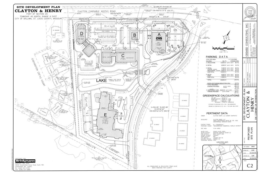
6 Exhibit 2: Proposed Site Development Plan by others Job# /22/09 CBB Crawford, Bunte, Brammeier Traffic and Transportation Engineers
7 No-Build Conditions for Year This scenario reflects traffic conditions representative of background growth 1% per year as well as the full occupancy of the retail component of Town and Country Crossing in 2011 constructed space, but currently vacant. No-Build Conditions for Year This Scenario reflects traffic conditions representative of background growth 0.% per year from 2011 to 2031 as well as the build-out of the residential portion of Town and Country Crossing. Build Conditions for Years 2011 and These scenarios reflect the build-out of the subject development site in addition to the respective No-Build conditions. The following report presents the methodologies, assumptions findings and conclusions from the analyses of the Base, No-Build and Build conditions in accordance with the scope of work agreed upon with the various review agencies. Crawford, Bunte, Brammeier May, 2009 Page 4
8 Driveway Access Review This section of the report discusses in detail the proposed driveway locations with respect to agency access management guidelines and desires. The proposed driveway spacings and corner clearances along Clayton Road were evaluated using MoDOT s Access Management Guidelines AMG, last updated Proposed Clayton Road Access MoDOT Access Management Guidelines - Driveway Locations MoDOT s AMG specifies a minimum corner clearance for driveways of 220 to 330 feet for minor roadways, measured from the edge of the public roadway to the centerline of the driveway. The minimum driveway spacing is 220 to 330 feet on minor roadways, measured centerline to centerline. MoDOT s AMG recommends that Driveways should also be lined up across the public roadway from each other whenever possible. When driveways are not lined up, the spacing should be measured from the closest driveway on either side of the road, except where a non-traversable e.g., raised median exists. MoDOT s AMG indicates a minimum spacing/corner clearance for right-in/right-out driveways of 110 to 16 feet on minor roads where non-traversable medians exist. Owner s Desires for Access The owner of the property prefers to have full access as close as possible to the Henry Avenue/Schoettler Road signal and access within or directly adjacent to the CVS tract on the northeast corner of the site. Physical Constraints - Location of Full Access Driveways Based on left-turn conflicts between the eastbound left-turns on Clayton Road at Henry Avenue/Schoettler Road and the westbound left-turns into the proposed drive, a full access driveway location adjacent to the CVS tract could not be accommodated in the available distance. The 21 foot design length required includes: a minimum turning radius 2 feet, deceleration/storage length 90-feet and a transition taper 100-feet requirements assuming that the existing raised median for the eastbound left-turn is not shortened. Since MoDOT indicated that they will not allow the median to be shortened, if left-turns are allowed at that location, they could slow westbound traffic and/or interfere with the westbound through lanes. As a result, full access should be located a minimum of 220 feet west of the end of the existing raised median. Recommended Site Access Configuration In order to obtain the owner s desired access and to meet MoDOT s AMG, the following access was considered. Exhibit 3 illustrates the site access issues discussed below. One reasonable location for full access along the site s Clayton Road frontage would be opposite Rue de Gascony. This location would meet the AMG alignment suggestion as well as provide the maximum distance away from the signal to avoid left-turn conflicts as well as meet the Crawford, Bunte, Brammeier May, 2009 Page
9 minimum corner clearance ± 60-foot corner clearance from Henry Avenue. This location is marked A on Exhibit 3. As mentioned above, full access driveways should be 220 to 330 feet west of Henry Avenue to satisfy the AMG corner clearance requirement and 220 to 330 feet east apart from one another to meet the driveway spacing requirements. According to the AMG, a second full access drive could be located within the CVS frontage between Henry Avenue and the recommended full access driveway opposite Rue de Gascony. These locations are marked B and C on Exhibit 3. However, as discussed in the physical constraints section, a full access driveway at that location would not operate properly and has the potential to create congestion and possibly blockage of the westbound travel lanes. Alternatively, if the second proposed access location was limited to right-in/right-out with a median added to Clayton Road between the signal and Rue de Gascony/proposed full access drive for the site, the AMG driveway spacing would be reduced to 110 to 16 feet. There appears to be adequate pavement width to add a 4-foot raised median without widening Clayton Road. The proposed eastern driveway could be restricted to right-in/right-out only by a raised median resulting in a ± 170-foot driveway spacing to Rue de Gascony and the proposed full access driveway. This location is marked as D on Exhibit 3. The operational analyses presented later in this report assume the recommended access plan with full access opposite Rue de Gascony and a right-in/right-out only access adjacent to the CVS tract. Proposed Henry Avenue Access Based on the site plan submitted to the City See Exhibit 2, the north Henry Avenue driveway is located approximately 12 feet centerline-to-centerline south of the existing Clayton Corners Drive and the south driveway is located approximately 390 feet south of the proposed north driveway. It is our understanding that the City of Ballwin does not have specific access guidelines, but generally follows St. Louis County standards on traffic and transportation issues. However, SLCDHT does not have any specific access guidelines either. MoDOT s feet centerline-to-centerline requirements for a state highway could be considered excessive for applications on Henry Road. An optimal location for the proposed north site driveway would be opposite Clayton Corners Drive. However, the current site plan is not unreasonable for several reasons. The grades on the site make the alignment difficult which would result in an extremely steep driveway 7% or more. Both side-streets Clayton Corners and the proposed north driveway are two-lanes and have a relatively low number of turns in and out. The inbound left-turns from Henry Avenue do not overlap and will not create any conflicts. The outbound left-turns could create conflicts, but the frequency is expected to be very low for concurrent existing left-turns and adequate sight distance is available. As a result, the 12-foot offset between Clayton Corners Drive and the proposed north site driveway is not unreasonable. Crawford, Bunte, Brammeier May, 2009 Page 6
10
11 Existing Roadway Conditions Area Roadway System The study evaluated conditions along Clayton Road Missouri Route HH with the limits of Rue de Gascony to the west. Clayton Road is a minor arterial serving west St. Louis County that is owned and maintained by MoDOT adjacent to the site. Clayton Road is generally a five-lane roadway two lanes in each direction with a center left-turn lane west of Henry Avenue/Schoettler Road and generally a seven-lane roadway three lanes in each direction with separate left-turn lanes east to Woods Mill Road. An auxiliary eastbound right-turn lane is present at Town and Country Crossing. Clayton Road has a posted speed limit of 40 miles per hour mph. The intersections of Clayton Road with Henry Avenue/Schoettler Road, Town and Country Crossing/Village Green Parkway, and Woods Mill Road are signalized and operate on coordinated timing plans. Schoettler Road is generally a two-lane urban collector with several intersections providing separate left-turn lanes. Schoettler Road is owned and maintained by SLCDHT and has a posted speed limit of 40 mph. Schoettler Road serves primarily residential land uses to the north and ultimately has a connection to South Outer Forty near the Chesterfield Parkway East interchange. At the intersection of Clayton Road, two southbound left-turn lanes and a shared thru/right-turn lane are present. South of Clayton Road, Schoettler Road changes name to Henry Avenue, and ownership and maintenance is by the City of Ballwin. Henry Avenue includes separate northbound left and right-turn lanes as well as a thru lane at the signalized intersection with Clayton Road. South of Clayton Road, Henry Avenue transitions back to a two-lane roadway. Henry Avenue has a posted speed limit of 3 mph. Town and Country Crossing Drive provides access to the Town and Country Crossing development opposite Village Green Parkway. The retail buildings on the Town and Country Crossing are built, but not completely occupied, while the planned residential portion is expected to lag several years due to current economic conditions. Village Green Parkway, Woods Mill North and Woods Mill Road serve commercial land uses close to Clayton Road and residential subdivisions further removed from Clayton Road. Existing Traffic Volumes CBB previously performed manual traffic counts during the morning 7:00-9:00 a.m. and afternoon 2:4-6:00 p.m. peak periods of a typical weekday at all of the study intersections as well as the Route 141 interchange in early October 2008 as part of a signal timing project for MoDOT. In order to validate those counts for current use and generate base traffic volumes, CBB performed manual traffic counts and queue observations in late April 2009 at the intersection of Clayton Road with Henry Avenue/Schoettler Road. Counts were also performed at the intersection of Rue de Gascony Lane with Clayton Road and Clayton Corners Drive with Henry Avenue. Crawford, Bunte, Brammeier May, 2009 Page 8
12 Based on those counts, the peak hours identified for analysis were the a.m. 7:1-8:1 a.m. and p.m. 4:4-:4 p.m. peak hours. As discussed in the Technical Memorandum submitted by CBB on April 24, 2009, the 2008 and 2009 traffic volumes at the intersection of Clayton Road at Henry Avenue/Schoettler Road are very similar. However, in order to be conservative in our analyses, the higher volume was assumed where variations were found to compile base traffic levels. Exhibit 4 graphically summarizes the Base Traffic Volumes on the surrounding roadways. Crawford, Bunte, Brammeier May, 2009 Page 9
13 , n ee Gr ge lla Vi & Co untry sing Cros Existing Retail Shops Town and Country Crossing Development 0% Occupied idential Future Res untry o Town and C lopment e v e Crossing D 1 1 Vacant nc yto Cla Proposed Development ad Ro ill sm od Wo Town , u Ro 16 3, ,1 16 C H te H to lay , , ay rkw Pa ad Ro tler oet Sch y on asc eg ed Ru ad o nr , , , n.t.s. ers orn Legend nry He = Existing Traffic Signal ue en Av = Side Street Stop Control XX = AM Peak Hour Traffic XX = PM Peak Hour Traffic Exhibit 4: Base Traffic Volumes Combination of October 2008 and April 2009 Counts by CBB Job# /22/09 CBB Crawford, Bunte, Brammeier Traffic and Transportation Engineers
14 No-Build Conditions Background Traffic and Other Approved Developments At the time of the 2008 traffic counts, it is our understanding that the retail buildings within the Town and Country Crossing development were completely built, but only partially occupied. Target, Whole Foods and select few businesses on the north end were in operation. Based on the forecasted trip generation from the original traffic study completed in January 2004 by CBB for the Town and Country Crossing development, the anchors alone were expected to generate approximately half of the development s retail trips. Therefore, it can be reasoned that half of the development traffic is already accounted for in the 2008 traffic counts. This appears reasonable also based on our comparison of the previously projected turning movements with the October 2008 traffic counts. Since the Town and Country Crossing retail development is fully built but not occupied, traffic to that development was increased for the 2011 No-Build Scenario to account for the full occupancy of the remaining retail space. The 2008 counted volumes oriented to Town and Country Crossing Drive at Clayton Road westbound left-turn, eastbound right-turn, northbound left-turn and northbound right-turn was doubled and extended through the study area. Additionally, a nominal amount of traffic -20 vph was also added to the thru movements on Woods Mill Road at Clayton Road to account for future trips using the Woods Mill Road to and from the north to access Town and Country Crossing. The future residential portion of the Town and Country Crossing site would be located on the south side of Clayton Road between Town and Country Crossing Drive and Henry Avenue. In the scoping meeting, it was agreed that the residential development would most likely occur after 2011; therefore, its traffic would be accounted for in the design horizon 2031 traffic scenarios only. It was estimated that 6 condominium/townhome units could occupy that space to complete the build-out of the Town and Country Crossing site. The projected background growth was based on historical Average Daily Traffic ADT data obtained from MoDOT s count maps from 1988 to Figure 1 illustrates the historical traffic trends for Clayton Road. The traffic volumes have fluctuated greatly between approximately 32,000 vehicles per day vpd to 40,000 vpd over the past 18 years resulting in an annual increase of approximately 0.3% per year on average. Crawford, Bunte, Brammeier May, 2009 Page 11
15 Figure 1: Historical Traffic Data Clayton Road West of Historical Counts Average Annual Growth is 0.3% per year 42,000 40,000 Volume vpd 38,000 36,000 34,000 32,000 Historical ADT Expon. Historical ADT 30, Year The ADT has constructed after peaking in As a result, we propose to use an annual growth rate of 1% for Clayton Road within the study area for the short term growth 2009 to 2011, which represents an overall growth of approximately 2%. This represents a very conservative approach based on the historical data. However, to address the 20-year design horizon, we propose to use a lower annual growth rate of 0.% for Clayton Road 2011 to 2031, which represents an overall increase of 10.% over 20 years No-Build Traffic Volumes Based upon the anticipated completion and full occupancy of the proposed development by 2011, the short-term background growth 2% overall and the full occupancy of the Town and Country Crossing retail development was aggregated with the Base Traffic Volumes Exhibit 3 to determine the 2011 No-Build traffic volumes. Exhibit illustrates the 2011 No-Build Traffic Volumes for the study intersections. Year 2031 No-Build Traffic Volumes In order to consider long-term planning, twenty-year traffic forecast were also developed. The 2031 No-Build Traffic Volumes, as presented in Exhibit 6, are reflective of an additional annual growth rate of 0. % per year 10.% overall for 20 years, as well as the build-out of the residential portion 6 condominium/townhome units of the Town and Country Crossing development. Crawford, Bunte, Brammeier May, 2009 Page 12
16 , n ee Gr ge lla Vi & Co untry sing Cros Existing Retail Shops Town and Country Crossing Development 100% Fully Occupied idential Future Res untry o Town and C lopment e v e Crossing D 1 1 Vacant nc yto Cla Proposed Development ad Ro ill sm od Wo Town , u Ro 16 3, ,1 16 C H te H to lay , , ay rkw Pa ad Ro tler oet Sch y on asc eg ed Ru ad o nr , , , , n.t.s. ers orn Legend nry He = Existing Traffic Signal ue en Av = Side Street Stop Control XX = AM Peak Hour Traffic XX = PM Peak Hour Traffic Exhibit : 2011 No-Build Traffic Volumes Job# /22/09 CBB Crawford, Bunte, Brammeier Traffic and Transportation Engineers
17 , n ee Gr ge lla Vi & Co untry sing Cros , Existing Retail Shops Town and Country Crossing Development 100% Fully Occupied idential Future Res untry o Town and C lopment e v e Crossing D mes ms/townho iu in m o d n 6 Co ccupied Built and O 1 1 nc yto Cla Proposed Development ad Ro ill sm od Wo Town ,19 18 u Ro ,3 10 C 16 3, H te H to lay , ay rkw Pa ad Ro tler oet Sch y on asc eg ed Ru ad o nr , 3 0 1, , 0 1 2, , , n.t.s. ers orn Legend nry He = Existing Traffic Signal ue en Av = Side Street Stop Control XX = AM Peak Hour Traffic XX = PM Peak Hour Traffic Exhibit 6: 2031 No-Build Traffic Volumes Job# /22/09 CBB Crawford, Bunte, Brammeier Traffic and Transportation Engineers
18 Site-Generated Traffic The proposed development is located on the southwest quadrant of Clayton Road and Henry Avenue. Four commercial buildings are proposed near Clayton Road with a variety of uses which include: a CVS Pharmacy, general retail space, a sit-down restaurant, a coffee shop with drive-thru window, a bank with drive-thru lanes and general office space. A fifth building is anticipated to be senior living located south of the commercial area along the west side of Henry Avenue. Based on the previous access discussion above, one full access drive opposite Rue de Gascony and one right-in/right-out were assumed on Clayton Road. The site was also assumed to have two full access drives on Henry Avenue. The site plan with the recommended access plan is illustrated in Exhibit 3 herein. Trip Generation As a primary step in this analysis, traffic forecasts were prepared to estimate the level of traffic that the proposed development would generate during each peak hour. These forecasts were based upon information provided in the Trip Generation Manual, Eighth Edition, published by the Institute of Transportation Engineers ITE. This manual, which is a standard resource for transportation engineers, is based on a compilation of nationwide studies documenting the characteristics of various land uses. Based upon the recommended procedure for estimating trip generation outlined in the Trip Generation Handbook, A Recommended Practice, also published by ITE March 2001, the regression equation was utilized for: Land Use: 820 Shopping Center pg 1497 The average trip rates were used for: Land Use: 710 General Office Building pg 1194 Land Use: 881 Pharmacy/Drugstore with Drive-Thru pg 1714 Land Use: 912 Drive-In Bank pg 1746 Land Use: 932 High-Turnover Sit-Down Restaurant pg 1794 Land Use: 937 Coffee/Donut Shop with Drive-Thru pg 180 Land Use: 2 Continuing Care Retirement Community pg 23 It should be noted that ITE provides various categories of trip generation for senior living facilities. Several similar senior housing land uses were compared with regards to their trip generation. These facilities tend to have lower traffic demands than other multi-family residential facilities since some residents may not have a personal vehicle or license to drive. In fact, several facilities of this nature provide transportation for their tenants in the form of scheduled trips on a van or mini-bus, thereby minimizing the number of trips into and out of the facility by the residents. As a result, a large share of the peak hour traffic is generated by employees. Furthermore, most residents typically arrive and depart during off-peak periods. For the various senior housing land uses, the Continuing Care Retirement Community is expected to generate the most traffic during the peak hours; therefore, it was utilized in our trip estimation in order to be conservatively high. Crawford, Bunte, Brammeier May, 2009 Page 1
19 The resulting traffic projections for the proposed development are shown in Table 1. It is important to note that the ITE estimates assume that each of the development s components would be freestanding. Instead, the commercial uses would share parking and access, and published studies show that patrons of multi-use developments often visit more than one store within a center on a single visit. As a result, a 10% and 20% reduction was applied to several of the land uses to account for motorists that visit more than one use on the site as part of a single trip during the a.m. and p.m. peak hour, respectively. No reductions were applied to the proposed pharmacy, senior living community or general office since those uses would be expected to generate a higher proportion of destination trips. Table 2 summarizes the common trip assumptions. Consequently, the proposed development would be expected to generate a total of approximately 370 external trips during the weekday a.m. peak hour and 490 external trips during the weekday p.m. peak hour. However, it should be noted that not all of these trips would represent new traffic on the adjacent roadways. Specifically, a significant portion of the traffic attracted to this site would already be traveling on Clayton Road or Henry Avenue as part of another trip; i.e., pass-by trips. Based upon statistical information provided in the Trip Generation Handbook, A Recommended Practice the pass-by trip percentages summarized in Table 2 were assumed for the proposed uses. These pass-by trips would create turning movements at the driveways serving the site, but they would not represent new traffic on the adjacent roadways. Therefore, the development would be expected to generate a total of 20 and 27 new trips during the a.m. and p.m. peak hours, respectively. Directional Distribution Access to the site is proposed via two access drives on Clayton Road and two access drives on Henry Avenue. The site-generated trips were assigned into and out of the proposed development based upon anticipated directional distributions. Based on the projected trip levels it should be noted that a % change in directional distribution would affect new trips by 8 vph or less during the p.m. peak hour. The pass-by trips will be assigned based on the existing traffic volumes along the adjacent roadways, while the new site-generated trips will be assigned as shown below: 8% to and from east on Clayton Road o 12% to and from the east on Clayton Road o 20% to and from northbound Route 141; o 20% to southbound Route 141 o 20% from southbound Route 141 via Woods Mill Road o 2% to and from the north on Woods Mill Road; o 2% to and from the south on Woods Mill Road; o 2% to and from the north on Village Green; 2% to and from the west on Clayton Road; 10% to and from the north on Schoettler Road; and 7% to and from the south on Henry Avenue. Crawford, Bunte, Brammeier May, 2009 Page 16
20 Table 1 - Site Generated Traffic Land Use Size AM Peak Hour PM Peak Hour In Out Total In Out Total Pharmacy/Drugstore with Drive-Thru 12,900 ft Shopping Center General Retail 13,10 ft High-Turnover Sit-Down Restaurant,600 ft Coffee Shop with Drive-Thru 1,70 ft Drive-In Bank 3 Lanes General Office Building 3,70 ft Retirement Community 12 Units Subtotal Common Trip Reduction see Table Total Trips Pass-by Trips See Table New Trips Land Use Table 2 - Common and Pass-by Trip Assumptions Common Trip Assumptions Pass-by Trip Assumptions AM Peak Hour PM Peak Hour AM Peak Hour PM Peak Hour Pharmacy/Drugstore with Drive-Thru 0% 0% 49% 49% Shopping Center General Retail 10% 20% 2% 34% High Turnover Sit-Down Restaurant 10% 20% 40% 43% Coffee Shop with Drive-Thru 10% 20% 0% 0% Drive-In Bank 10% 20% 30% 47% General Office Building 0% 0% 0% 0% Retirement Community 0% 0% 0% 0% Crawford, Bunte, Brammeier May 1, 2009 Page 17
21 The site-generated trips were assigned to the roadways as shown in Exhibit 7. Please note that the values shown in red on the exhibit are deductions resulting for the diversion of pass-by trips. Generally, the new trips were assigned with approximately two-thirds of the site traffic to the Clayton Road Entrances and the remaining one-third to the Henry Road access drives Build Traffic Volumes The site-generated traffic volumes Exhibit 7 were aggregated with the 2011 No-Build Traffic Volumes Exhibit in order to determine the total volumes forecast in the 2011 Build Scenario. The 2011 Build Traffic Volumes for both peak hours are shown in Exhibit Build Traffic Volumes The site-generated traffic volumes Exhibit 7 were also aggregated with the 2031 No-Build Traffic Volumes Exhibit 6. The resulting 2031 Build Traffic Volumes are depicted in Exhibit 9. Crawford, Bunte, Brammeier May, 2009 Page 18
22 40 n ee Gr ge lla Vi 3 ad Ro ill sm od Wo Town & Co Existing Retail Shops Town and Country Crossing Development sing Cros Henry Avenu untry 2 20 idential Future Res untry o Town and C lopment e v e Crossing D e 3 30 u Ro 20 C H te H to lay ay rkw Pa ad Ro tler oet Sch y on asc eg ed Ru ad o nr Proposed Development 2 30 n.t.s. ers orn nc yto Cla Legend Exhibit 7: Total Site-Generated Trips = Existing Traffic Signal = Side Street Stop Control XX = AM Peak Hour Traffic XX = PM Peak Hour Traffic Note: Values shown in red represent a reduction in volume due to pass-by traffic. Job# /22/09 CBB Crawford, Bunte, Brammeier Traffic and Transportation Engineers
23 , n ee Gr ge lla Vi ad Ro ill sm od Wo , Town & Co untry sing Cros Existing Retail Shops Town and Country Crossing Development 100% Fully Occupied idential Future Res untry o Town and C lopment e v e Crossing D e Henry Avenu 20 Proposed Development Ro Cl , ,1 20 1, , , u H te H o ayt , , ay rkw Pa ad Ro tler oet Sch y on asc eg ed Ru ad o nr , , , 1 2, , , ers = Existing Traffic Signal = Side Street Stop Control XX = AM Peak Hour Traffic XX = PM Peak Hour Traffic Exhibit 8: 2011 Build Traffic Volumes Legend n.t.s. orn nc yto Cla Vacant Job# /22/09 CBB Crawford, Bunte, Brammeier Traffic and Transportation Engineers
24 , n ee Gr ge lla Vi ad Ro ill sm od Wo 16 Town & Co untry sing Cros Existing Retail Shops Town and Country Crossing Development 100% Fully Occupied 1 1 ers = Existing Traffic Signal = Side Street Stop Control XX = AM Peak Hour Traffic XX = PM Peak Hour Traffic Exhibit 9: 2031 Build Traffic Volumes Legend n.t.s. orn nc yto Cla idential Future Res untry o Town and C lopment e v e Crossing D mes ms/townho iu in m o d n 6 Co ccupied Built and O e Henry Avenu 20 Proposed Development 16 3, Ro Cl , ,3 3, , , , , , u H te H o ayt , 1 1, , ay rkw Pa ad Ro tler oet Sch y on asc eg ed Ru ad o nr, , 1 2, , , Job# /22/09 CBB Crawford, Bunte, Brammeier Traffic and Transportation Engineers
25 Operational Analysis The following sections of the report discuss the operational aspects of the current and future traffic conditions at the study intersections. This analysis reviewed the need for auxiliary turn lanes per volume criteria, recommended lane configurations of the proposed driveways, and available sight distance at the proposed driveways. Auxiliary Turn Lane Analysis The need for dedicated right-turn lanes on Clayton Road at the proposed entrances was evaluated using MoDOT s AMG. Clayton Road has a center left-turn lane, which can accommodate leftturn movements entering the site. Based on the recommended access plan the center median should be extended to restrict left-turns at the proposed eastern driveway. Therefore, it is not necessary to evaluate the need for dedicated left turn lanes on Clayton Road. The MoDOT guidelines consider auxiliary lanes an asset in promoting safety and improved traffic flow. Separate turn lanes are intended to remove turning vehicles from the through lanes to reduce the potential number of rear-end collisions at intersections. Since the City of Ballwin does not have any specific turn lane requirements, the MoDOT AMG left and right-turn lane methodology was also applied to the forecasted volumes for both proposed driveways on Henry Avenue. Right-Turn Lane Warrants The MoDOT figure, Right Turn Lane Warrant for a Four-Lane Roadway, was utilized to compare traffic volumes at the intersection of Clayton Road with the proposed western driveway and the proposed right-in/right-out eastern driveway. Figures 1 and 2 in the Appendix illustrate the 2011 Build Traffic Volumes plotted on the MoDOT figure for the evaluation of right-turn lanes. Based on the minimal number of right-turns needed to satisfy the criteria in conjunction with the existing high traffic volumes along Clayton Road, separate eastbound right-turn lanes are warranted on Clayton Road at both proposed driveways. The MoDOT figure, Right Turn Lane Warrant for a Two-Lane Roadway, was utilized to compare traffic volumes at the intersection of Henry Avenue with the proposed northern driveway and southern driveway. Figures 3 and 4 in the Appendix illustrate the 2031 Build Traffic Volumes plotted on the MoDOT figure evaluation of right-turn lanes. Based on the minimal number of right-turns and the relatively moderate level of through traffic on Henry Avenue, separate southbound right-turn lanes are NOT warranted on Henry Avenue at either of the proposed driveways. Left -Turn Lane Warrants The MoDOT figure, Left Turn Lane Warrant for Two-Lane Roadway<= 40 mph, was utilized to compare traffic volumes at the intersections of Henry Avenue at both proposed drives. It should be noted that if left-turn volumes are less than 10 vph, then a left-turn lane is not justified, unless warranted by crash experience. Since the proposed southern driveway is expected to generate Crawford, Bunte, Brammeier May, 2009 Page 22
26 less than 10 vph, that location would not require a separate left-turn lane. Figure in the Appendix illustrates the 2031 Build Traffic Volumes plotted on the MoDOT figure for evaluations of left-turn lanes. Based on the low number of left-turns and the moderate levels of through traffic along Henry Avenue, a separate northbound left-turn lane is NOT warranted on Henry Avenue at either of the proposed driveways. Driveway Geometrics According to MoDOT s AMG, Low Volume Commercial driveways are categorized as driveways that serve less than 10 vph during the peak hour. Based on the projected traffic volumes during the peak hours, the proposed right-in/right-out adjacent to the CVS as well as both access driveways on Henry Road would be considered Low Volume Commercial Driveways. Low Volume Commercial Driveways are recommended to have a width of 28-feet two-lanes to 42-feet three-lanes with a minimum throat depth of 20-feet. The proposed 30- foot wide driveways are consistent with those guidelines. Medium Volume Commercial driveways are categorized as driveways that serve between 10 and 400 vph during the peak hour. Based on the projected traffic volumes the proposed western full access drive opposite Rue de Gascony would be considered a Medium Volume Commercial Driveway. Medium Volume Commercial Driveways are recommended to have a width of 42- feet three-lanes to 4-feet four-lanes and a minimum throat depth of 60-feet. Driveway Sight Distance Adequate sight distance is necessary at intersections to allow drivers to perceive potentially conflicting vehicles and allow those motorists sufficient time to adjust their speed to avoid a collision or make a choice of when to cross or enter the mainline traffic flow. All drivers approaching or stopped at the intersection should have an unobstructed view of the entire intersection so that potential collisions can be avoided. It should be noted that MoDOT utilizes a tiered approach in their requirements based upon Table III-1 and Figure IX-41 of the AASHTO Green Book 1994 Edition. The three levels of sight distance compliance are: minimum entrance stopping sight distance, minimum entering sight distance and design entering sight distance. The design entering sight distance is the largest, most conservative requirement and is preferred for optimal sight distance. The design entering sight distance for the proposed entrances on Clayton Road would be 7 feet. As verified in the field, the driveway has more than adequate sight distance in excess of 800 foot available. Thus, the sight distance for the proposed commercial driveway exceeds the design entering sight distance recommended by MoDOT. However, it should be acknowledged that the eastbound queue from the Henry Avenue Schoettler Road traffic signal can obstruct the through lanes and ultimately limit the available sight distance during those occurrences. SLCDHT sight distance guidelines were utilized for the driveways on Henry Avenue. These guidelines assume that vehicles are entering roadway from a stopped position and incorporates the cross-section and the design speed 3 mph posted + mph = 40 mph design of Henry Avenue. The minimum sight distance for left-turns exiting from the minor road is 44 feet. Crawford, Bunte, Brammeier May, 2009 Page 23
27 Based on our cursory field observations of the available sight distance, the visibility to and from the south at the northern driveway on Henry Avenue is marginal. Therefore, the site designer should verify that adequate sight distance is provided on the site plan. However, careful consideration should be given to sight distance obstructions when planning any future aesthetics enhancements, such as berms, fencing and landscaping, to ensure that these improvements do not obstruct the view of entering and exiting traffic at the site intersections with the public roads. It is generally recommended that all improvements higher than 3. feet above the elevation of the nearest pavement edge be held back at least 20 feet from the traveled roadway. Capacity Analysis Methodology It is also necessary to evaluate the traffic operations at the study intersections. The operating conditions at the study intersections were evaluated using SYNCHRO 7, which is based on study procedures outlined in the Highway Capacity Manual, last updated in 2000 by the Transportation Research Board. This manual, which is used universally by traffic engineers to measure roadway capacity, establishes six levels of traffic service: Level A "Free Flow, to Level F "Fully Saturated". Levels of service LOS are measures of traffic flow which consider such factors as speed, delay, traffic interruptions, safety, driver comfort, and convenience. Level C, which is normally used for highway design, represents a roadway with volumes ranging from 70% to 80% of its capacity. Level D is considered acceptable for peak period conditions in urban areas, while LOS C is preferred in rural areas. LOS thresholds and criteria vary depending upon the type of traffic control used at an intersection i.e. whether it is signalized or unsignalized. At signalized intersections, average control delay per vehicle is estimated for each movement and aggregated for each approach and the intersection as a whole. At intersections with partial side-street stop control, delay is only calculated for the minor movements - but not for the intersection as a whole - since motorists on the main road are not required to stop. In addition, signalized intersections are designed to carry higher traffic volumes, so longer delays are tolerated than at unsignalized intersections. Table 3 summarizes the thresholds for each LOS. Table 3 Level of Service Thresholds Level of Service LOS Control Delay per Vehicle sec/veh Signalized Intersections Unsignalized Intersections A < B > > 10-1 C > 20-3 > 1-2 D > 3- > 2-3 E > -80 > 3-0 F > 80 > 0 Crawford, Bunte, Brammeier May, 2009 Page 24
28 Capacity Analysis Results The traffic signals along Clayton Road within the study area are part of a coordinated traffic system Henry/Schoettler to Route 141 northbound ramps which runs on a 120-second cycle during the weekday a.m. peak hour and a 130-second cycle during the p.m. peak hour. The traffic signal at Clayton Road and Henry Avenue/Schoettler Road operates with protected-only southbound dual left-turn lanes and eastbound left-turns, while the northbound and westbound left-turns operate under protected plus permitted phasing. The traffic signal at Clayton Road and Village Green/Town and Country Crossing Road signal operates with protected-only east-west left-turns, while the north-south approaches operate spilt phased. The traffic signal at Clayton Road and Woods Mill Road operates with protected-only southbound and westbound left-turns, while the northbound and eastbound left-turns operate under protected plus permitted phasing. A right-turn overlap phase is also included for the southbound approach. The study intersections were evaluated using the traffic volumes for each scenario and design horizon presented earlier in the report. The Base Traffic, 2011 No-Build, 2031 No-Build, 2011 Build and 2031 Build operational evaluations are summarized in Table 4 for the weekday a.m. and p.m. peak hours. These tables identify the levels of service and average delays for comparison during each peak hour. Base Traffic Conditions Based upon field observations, as well as operational analyses of the base traffic volumes, the following constraints were identified at the study intersections: The eastbound approach of Clayton Road at Henry Avenue/Schoettler Road operates at less than desirable conditions during the a.m. peak hour. The existing eastbound through traffic is very high with nearly 2,000 vph. The existing volume to capacity ratio is estimated at 1.19, which indicates volume currently exceeds the existing theoretical capacity during the a.m. peak hour. While some traffic signal timing changes may decrease the delays, additional eastbound capacity would likely be needed to make significant improvements to operating conditions in the a.m. peak hour. Lengthy eastbound queues were observed in the through lanes that extended well beyond the Rue de Gascony intersection regularly during the a.m. peak hour. However, the eastbound left-turn queue only reached a maximum of 7 vehicles and never extended past the existing raised median, even during the a.m. peak hour. The northbound approach of Henry Avenue at Clayton Road also operates at less than desirable conditions during the a.m. peak hour. The conditions are a result of the coordinated signal timing along Clayton Road and the extremely heavy traffic oriented to Route 141, which limit the ability to provide sufficient green time to Henry Avenue in the a.m. peak hour. Crawford, Bunte, Brammeier May, 2009 Page 2
29 Although the northbound approach operates at less than desirable levels during the a.m. peak hour, the maximum queue was 13 vehicles, which resulted in a maximum queue length approximately half the distance from Clayton Road to Clayton Corners Drive. These queues created no interference with Clayton Corners Drive. Conversely, the southbound approach of Shoettler Road operates at less than desirable conditions during the p.m. peak hour. Again, the conditions are a result of the coordinated signal timing along Clayton Road and the heavy westbound traffic, which limits the green time for Schoettler Road in the p.m. peak hour. It should be noted that all of the other study intersections Clayton Road with Woods Mill Road, Clayton Road with Village Green/Town and Country Crossing, Clayton Road with Rue de Gascony Court and Henry Avenue with Clayton Corners operate at acceptable levels of service during both peak hours. No-Build Traffic Conditions 2011 No-Build Conditions were also analyzed. As previously stated, the traffic forecasts for the 2011 No-Build Condition accounts for the full occupancy of the retail portion of Town and Country Crossing as well as 2% overall background growth along Clayton Road. In general, the additional traffic will increase delays at all locations slightly. The existing approaches with poor operating conditions will be further exacerbated. It is a foregone conclusion that conditions along an already congested Clayton Road would worsen somewhat. For example, the eastbound delays and queues will get slightly worse in the morning peak hour. However, the northbound queue on Henry Avenue is not expected to increase by more than 1 vehicle, therefore the queues will still not impact Clayton Corners Drive No-Build Conditions were also evaluated in an effort to address long term planning matters. The 2031 No-Build Conditions include the full occupancy of the retail and residential portions of Town and Country Crossing as well as background growth over the next twenty years. As expected, conditions along an already congested Clayton Road would worsen. Specifically, westbound Clayton Road and southbound Woods Mill Road will degrade to poor levels during the p.m. peak hour. Timing adjustments could slightly improve conditions between Woods Mill Road to west of Town and Country Crossing, but the westbound approach mainly through movements will be constrained at Henry Avenue/Schoettler Road since the roadway changes from three to two westbound lanes west of the signal. Crawford, Bunte, Brammeier May, 2009 Page 26
30 Table 4 - Operating Conditions Intersection/Movement Existing Conditions 2011 No-Build 2031 No-Build 2011 Build Condition Build Condition 1 AM Peak PM Peak AM Peak PM Peak AM Peak PM Peak AM Peak PM Peak AM Peak PM Peak Clayton Road at Henry Avenue/Schoettler Road signalized E 73.1 F 83.9 F F 11.4 F 17.4 C 27.1 C 28.1 C 30.3 C 29.9 Eastbound Clayton Road v/c =1.08 v/c =1.11 v/c =1.2 v/c =1.19 v/c =1.2 C 33.6 Westbound Clayton Road A 9.1 C 21.8 A 8.4 D 36.7 A 9.1 E 73. B 10.9 D 1.4 B 11.6 E 71.6 Northbound Henry Avenue E 7.0 D 44.1 E 9. D 43.6 E 64.1 D 42.0 E 62.4 D 41.3 E 67.7 D 42.2 Southbound Schoettler Road D 0.4 E 73.6 D 0.4 E 7.3 D 2. F 83.1 D 2.3 E 76.4 D 4.3 F 90.7 Overall Intersection D 4. C 30.0 E 60.6 D 38.7 F 92.0 E 60.6 E 78.0 D 47.3 F E 60.9 Clayton Road at Town and Country Crossing/Village Green Parkway signalized Eastbound Clayton Road A 7.3 A 9.8 A 9.2 B 10.7 B 12.0 B 10.4 A 9.2 B 10.7 B 12.8 A 9.8 Westbound Clayton Road B 16.3 C 21. B 18.9 D 38. B 18.0 F 108. B 18.9 D 0.6 B 17.8 D 4.4 Northbound Town and Country Crossing D 41.4 D 0.4 D 39.2 D 2.6 D 33.4 D 1.6 D 39.2 D 3.9 D 33.4 E 7.6 Southbound Village Green Parkway D 3.1 D 46.6 D 3.0 D 1.6 D 3.0 D 2.0 D 3.0 D 2.3 D 2.1 E 6.6 Overall Intersection B 12.6 B 19.9 B 14.6 C 32.3 B 16.1 E 77.7 B 14.6 D 39.9 B 16. D 42.4 Clayton Road at Old Woods Mill Road Signalized Eastbound Clayton Road A 9.0 C 23.1 A 9.0 C 23.9 B 11.0 C 27.3 A 9.0 C 21.2 B 12.1 C 30.8 Westbound Clayton Road B 17.7 D 3.2 B 18.4 D 37.4 C 21.2 D 41.6 B 18.4 D 3.6 C 22.4 D 3.8 Northbound Old Woods Mill Road D 38.8 D 37. D 38.8 D 38.2 D 38.8 D 38. D 38.8 D 4.2 D 41.9 D 47.2 Southbound Old Woods Mill Road C 22.6 D 48.4 C 23. D 4.7 C 22.3 F 82.7 C 23. D 3.1 C 21.3 D 3.2 Overall Intersection B 13.7 D 37.1 B 13.9 D 41.0 B 1. D 4.0 B 13.9 D 39. B 16.6 D 47.0 Clayton Road at Rue de Gascony Lane/Site Driveway Side-Street Stop Controlled Eastbound Left-Turn from Clayton Road A 9.6 C 16.9 A 9.7 C 19.6 A 10.0 D 26.3 A 9.6 C 18.1 A 9.8 C 23.8 Westbound Left-Turn from Clayton Road D 33.8 B 13.6 E 4.9 B 14.9 Northbound Site Driveway Exit Left-Turn F >200 F 6.6 F >200 F 79.2 Northbound Site Driveway Exit Right-Turn D 32.4 C 1.0 E 40.6 C 16.3 Southbound Rue de Gascony Lane C 1. B 12.2 C 1.8 B 12.3 C 16.9 B 12.3 F 2.2 E 37. F E.3 Henry Avenue at Clayton Corners Drive Side-Street Stop Controlled Westbound Clayton Corners Drive B 11.6 B 10.7 B 11.7 B 10.8 B 11.9 B 11.1 B 11.7 B 11.2 B 12.2 B 11.4 Southbound Henry Avenue A 0.3 A 0.1 A 0.3 A 0.1 A 0.3 A 0.1 A 0.3 A 0.1 A 0.3 A 0.1 Henry Avenue at Site Driveway - North Side-Street Stop Controlled Eastbound Site Driveway C 18. C 20.9 C 19.3 C 22.7 Northbound Henry Avenue A 0.4 A 0. A 0.4 A 0. Henry Avenue at Site Driveway - South Side-Street Stop Controlled Eastbound Site Driveway A 9.1 B 1.0 A 9.2 C 1.9 Northbound Henry Avenue A 0.1 A 0.2 A 0.1 A 0.2 Clayton Road at Proposed right-in/right-out Driveway Side-Street Stop Controlled Northbound Right-Turn Out of Site D 26.7 B 14.1 D 31.4 C 1.0 X XX.X - Level of Service Vehicular delay in seconds per vehicle 1 Traffic signal timings optimized Crawford, Bunte, Brammeier May, 2009 Page 27
31 Build Traffic Conditions 2011 Build Conditions aggregated the anticipated traffic from the proposed commercial development with the 2011 No-Build Traffic Volumes, which accounts for the full occupancy of the retail portion of Town and Country Crossing and 2% overall background growth. The forecasted volumes were analyzed using the same methodology applied to the No-Build scenarios in an attempt to quantify the net impacts associated with the proposed development. Minor signal timing modifications and/or offset modifications were made as a means to accommodate the increased westbound through traffic volumes at Town and Country Crossing and southbound approach of Woods Mill Road during the p.m. peak hour. As with the No-Build analysis, traffic progression along Clayton Road was maintained and the greenband for the predominant direction of traffic time of day dependent remained relatively constant no more than a few seconds deviation despite the signal timing modifications. During the a.m. peak hour, the operating conditions increased approximately 18 seconds overall at the intersection of Clayton Road and Henry Avenue/Schoettler Road with the largest increase occurring for the eastbound approach, which is already over capacity. During the p.m. peak hour, the operating conditions increased approximately 9 seconds overall at the intersection of Clayton Road and Henry Avenue/Schoettler Road with the largest increase occurring for the westbound approach in an attempt to better serve the north-south approaches. The overall impact to the other signalized intersections to the east is expected to be nominal during either time period. The unsignalized intersections along Henry Avenue are expected to operate at acceptable levels, primarily due to their relatively low turning volumes. The proposed full access entrance to Clayton Road opposite Rue de Gascony is expected to have less than desirable levels of service for the left-turns exiting the site to the west. Furthermore, both access driveways would be blocked frequently during the a.m. peak hour by the eastbound through lane queues from the Henry Avenue/Schoettler Road traffic signal. The ability of motorists to turn left onto Clayton Road from the proposed full access or Rue de Gascony would be expected to operate poorly during both peak hours. Extremely long delays are anticipated for someone turning left out of the development via the western drive during the a.m. peak hour, while the p.m. delays are expected to be approximately one minute. The 9 th percentile queue for the westbound left-turn movement into the proposed western driveway is forecasted to be less than 0-feet during the peak hours. As a result, the minimum deceleration distance 90 feet will accommodate the entering westbound left-turns without queuing into the westbound thru lane. The installation of a traffic signal along this stretch of Clayton Road to serve this development is not practical as a means of improving the exiting left-turn delays. It must be acknowledged that it is not uncommon along heavily traveled highways, such as Clayton Road, for motorists on many of the cross streets and private drives to incur lengthy delays. The presence of a center- Crawford, Bunte, Brammeier May, 2009 Page 28
32 left-turn lane does allow for a motorist to complete their turn in two stages as opposed to waiting for a simultaneous gap in both directions of traffic flow. For example, a motorist exiting the proposed development destined to the west on Clayton Road could wait for eastbound Clayton Road to clear, turn into the center-left-turn lane and then wait for a gap in the westbound flows to merge into traffic. This practice is common throughout the greater St. Louis Metropolitan area. It should be noted that MoDOT previously expressed concerns about providing a three-lane driveway one inbound lane and separate left and right exit lanes onto Clayton Road at the scoping meeting. As a result, the western driveway was also analyzed under a single northbound lane. The results of the single northbound lane access to Clayton Road are summarized in Table with only one lane. The northbound and southbound approaches degrade further Build Conditions were also evaluated in an effort to assist with long term planning. Assuming the physical improvements and signal operation modifications recommended in the 2011 Build Conditions, it is feasible to maintain operating conditions along Clayton Road comparable to the No-Build scenario for the Year The service levels of most approaches at all signalized intersections would with not change or degrade more than one letter grade example: LOS C to LOS D. Therefore, it can be concluded the impact of the development s traffic could be mitigated with above recommendations. Although, more significant improvements maybe required to address systematic congestion due to current conditions and traffic growth by Table Operating Conditions Single Northbound Exit Lane at Propsoed Full Access Intersection/Movement 2011 Build Condition 2031 Build Condition AM Peak PM Peak AM Peak PM Peak Clayton Road at Rue de Gascony Lane/Site Driveway Side-Street Stop Controlled Eastbound Left-Turn from Clayton Road A 9.8 C 18.2 A 9.8 C 23.8 Westbound Left-Turn from Clayton Road D 33.8 B 13.6 E 4.9 B 14.9 Northbound Site Driveway Exit Approach F >200 F 61.6 F >200 F 92.7 Southbound Rue de Gascony Lane F 2.2 E 37. F F.3 X XX.X - Level of Service Vehicular delay in seconds per vehicle Crawford, Bunte, Brammeier May, 2009 Page 29
33 Conclusion Crawford, Bunte, Brammeier has completed a study to evaluate the traffic impacts associated with a proposed commercial development in. The development site is located in the southwest quadrant of Clayton Road and Henry Avenue/Schoettler Road. A variety of uses are proposed including a CVS Pharmacy, general retail space, a sit-down restaurant, a coffee shop with drive-thru window, a bank with drive-thru lanes, general office space and a senior living facility. Two access drives are proposed to each Clayton Road and Henry Avenue. The purpose of the study was to determine an acceptable access plan for the site and identify the need for roadway improvements to mitigate the impact of the site s traffic. The focus of our analysis was the a.m., and p.m. peak hours of a typical weekday. After a detailed access review, it is recommend that one full access driveway be provided to Clayton Road opposite Rue de Gascony and one right-in/right-out only drive be located near the CVS property limit. A center median along Clayton Road is recommended to restrict left-turns by extending the existing median as shown in Exhibit 3. Base traffic conditions were observed and evaluated to reveal constraints that currently exist at the signalized intersection of Clayton Road with Henry Avenue/Schoettler Road northbound and eastbound approaches during the a.m. peak hour as well as the southbound approach during the p.m. peak hour. Year 2010 No-Build Conditions, which considered additional traffic related to the full occupancy of the retail part of Town and Country Crossing as well as 2% background growth along Clayton Road, were evaluated for comparison to initial occupancy of conditions of the site. Similar constraints are expected at the intersection of Clayton Road with Henry Avenue/Schoettler Road northbound and eastbound approaches during the a.m. peak hour as well as the southbound approach during the p.m. peak hour, slightly exacerbated by the increased traffic. The analysis of the 2011 Build Conditions determined that the following improvements would be beneficial in conjunction with the development of the proposed commercial development: A dedicated eastbound right-turn deceleration lane will be warranted on Clayton Road in advance of the proposed Full Access Drive opposite Rue de Gascony; A dedicated eastbound right-turn deceleration lane will be warranted on Clayton Road in advance of the proposed right-in/right-out only drive; Extension of the raised median on Clayton Road is recommended to restrict the east driveway to right-turns only and still allow left-turns into and out of the proposed west driveway and Rue de Gascony; Crawford, Bunte, Brammeier May, 2009 Page 30
34 The signal timing at the intersection of Clayton Road with Henry Avenue/Schoettler Road should be modified to provide a few additional seconds of green time to the southbound thru movement during the p.m. peak hour; and It is acknowledged that the proposed full access driveway opposite Rue de Gascony, will be frequently blocked by the eastbound queues from the adjacent signal at Henry Avenue/Schoettler Road in the a.m. peak hour. Providing separate left and right-turn lanes at Clayton Road will help to reduce the delays for the right-turn vehicles. In fact, some left-turn movements will choose to use the signalized access to westbound Clayton Road via Henry Avenue to reduce wait times and frustration, especially due the peak hours. Consequently, those turning movements and associated delays may be lower at the unsignalized driveway. Assuming the above physical improvements and signal timing modifications are implemented, it is feasible to maintain operating conditions along Clayton Road comparable to the No-Build Conditions for the Year The service levels of most approaches at the signalized intersections either do not change, or degrade only by one letter grade example: LOS C to LOS D. The impact of the proposed development s traffic could be lessened with the above recommendations. Crawford, Bunte, Brammeier May, 2009 Page 31
35 Trip Generation Memo Appendix Auxiliary Turn Lane Needs Analysis Figure 1 Right-Turn Lane Needs - Clayton Road at Propsoed West Driveway Figure 2 Right-Turn Lane Needs - Clayton Road at Propsoed Right-In/Right-Out Driveway Figure 3 Right-Turn Lane Needs - Henry Avenue at Propsoed North Driveway Figure 4 Right-Turn Lane Needs - Henry Avenue at Propsoed South Driveway Figure Left-Turn Lane Needs - Henry Avenue at Propsoed North Driveway Synchro 7 Outputs Base Conditions Year 2011 No-Build Conditions Year 2011 Build Conditions Year 2031 No-Build Conditions Year 2031 Build Conditions Crawford, Bunte, Brammeier May, 2009 Page 32
36 Technical Memorandum for Crawford, Bunte, Brammeier May 1, 2009

37 MEMORANDUM Date: April 24, 2009 To: From: Subject: Project: Mr. Jeff Baird, MoDOT Mr. Richard Beckman, SLCDHT Mr. Tom Aiken, City of Ballwin Mr. Mr. Dan Theis, Brinkman Mr. Bill Biermann, WB Properties, Mr. Rob Taylor, PR&S Lee Cannon, P.E., PTOE Brian Rensing, P.E., PTOE Technical Memorandum for Development of the SW Quadrant of Clayton Road with Henry Avenue/Schoettler Road CBB Job No As you are aware, Crawford Bunte Brammeier CBB is working on a traffic impact study for a proposed development in the southwest quadrant of Clayton Road and Henry Avenue/Schoettler Road in. As an initial step in the traffic study, we have established base traffic volumes for the roadways within the study area; forecasted the amount of trips that would be generated by the development; estimated the directional distribution of these trips; and identified growth rates for future traffic volumes. We have prepared the following memorandum to summarize these initial traffic study components. We ask that you review this memorandum and offer any thoughts or concerns that you may have. Crawford, Bunte, Brammeier will move forward with completing the remainder of the traffic study while the technical memorandum under review. For that reason, we ask that your agency offer comments and concerns as quickly as your schedule permits. Baseline Traffic Volumes The traffic study will evaluate conditions during the morning and afternoon peak periods of a typical weekday at the following intersections: Clayton Road at Henry Avenue/Schoettler Road; Clayton Road at Village Green/Town and Country Crossing; Clayton Road at Old Woods Mill Road; and All Proposed Site Entrances. CBB performed a manual traffic count and queue observations in late April 2009 at the intersection of Clayton Road at Henry Avenue/Schoettler Road. It should be noted that CBB previously performed manual traffic counts at all of the study intersections as well as the 40 Cottonwood Road - Suite B Glen Carbon, IL T F Craig Park Court - Suite 209 St. Louis, MO T F S. Meadowbrook Road Suite 300 Springfield, IL T F
38 April 24, 2009 Page 2 Route 141 interchange in early October 2008 as part of a signal timing project for MoDOT. Since the 2008 counts are within the MoDOT traffic impact criteria 2 or less years old, those counts were used as the base traffic conditions. In general, the 2008 and 2009 traffic volumes at the intersection of Clayton Road at Henry Avenue/Schoettler Road are very similar. Where variations were found, the higher volume for any given movement was applied to be conservative, and the surplus was extended through the system. The most appreciable difference was the eastbound through volume during the a.m. peak hour, which was approximately 170 vehicles per hour vph heavier in 2009, representing an 8% increase. It should also be acknowledged that traffic volumes fluctuate day to day with changes up to 10% generally considered normal variation. Exhibit 1 illustrates the traffic volumes which are intended to be used for the analysis of the existing conditions. The traffic volumes for the 2009 and 2008 counts are attached to the rear of this memo as Exhibit A and Exhibit B, respectively. Background Traffic and Other Approved Developments At the time of the 2008 traffic counts, it is our understanding that the retail components of the Town and Country Crossing development were completely built, but only partially occupied Target, Whole Foods and select few businesses on the north end. Based on the forecasted trip generation of the original traffic study completed in January 2004 by CBB for the Town and Country Crossing development, the anchors alone are expected to generate approximately half of the development s traffic. Therefore, it can be reasoned that half of the development traffic is already accounted for in the 2008 traffic counts. Since the Town and Country Crossing retail development is fully built but not occupied, we propose to increase traffic to the Town and Country Crossing development for the 2011 No- Build Scenario to account for the full occupancy of the remaining retail space. In order to keep the future traffic projections for the full occupancy of the Town and Country Crossing development relatively simple, we intend to double the 2008 traffic volumes oriented to Town and Country Crossing Drive westbound left-turn, eastbound right-turn, northbound left-turn and northbound right-turn and extend those trips through the study area. Additionally, a nominal amount of traffic -20 vph will also be added to the thru movements on Old Woods Mill Road at Clayton Road to account for future trips using the Old Woods Mill Road access to Town and Country Crossing. The future build-out of the Town and Country Crossing site also includes a residential portion on the south side of Clayton Road between Town and Country Crossing drive and Henry Avenue. In the scoping meeting, it was agreed that the residential development would likely occur after 2011; therefore, its traffic would be accounted for in the design horizon, 2031 traffic scenarios only. It was estimated that 6 condominium/townhome units could occupy the vacant area to complete the build-out of the Town and Country Crossing site. The projected background growth was based on historical Average Daily Traffic ADT data obtained from MoDOT s count maps from 1988 to Figure 1 illustrates the
39 April 24, 2009 Page 3 historical traffic trend for Clayton Road. The traffic volumes have fluctuated between approximately 32,000 vehicles per day vpd to 40,000 vpd over the past 18 years resulting in an annual increase of approximately 0.3% per year on average. Figure 1: Historical Traffic Data Clayton Road West of Historical Counts Average Annual Growth is 0.3% per year 42,000 40,000 Volume vpd 38,000 36,000 34,000 32,000 Historical ADT Expon. Historical ADT 30, Year The ADT has stabilized after peaking in As a result, we propose to use an annual growth rate of 1% for Clayton Road within the study area for the short term growth 2009 to 2011, which represents an overall growth of approximately 2%. This represents a very conservative approach based on the data. However, to address the 20-year design horizon, we propose to use an annual growth rate of 0.% for Clayton Road 2011 to 2031, which represents and overall increase of 10.%. Proposed Development The proposed development is located in the southwest quadrant of Clayton Road and Henry Avenue. Four commercial buildings are proposed near Clayton Road with a variety of uses which include: a CVS Pharmacy, general retail space, a sit-down restaurant, a coffee shop with drive-thru window, a bank with a drive-thru lanes and general office space. A fifth building is anticipated to be independent living located south of the commercial area along the west side of Henry Avenue. Two access drives are proposed to each Clayton Road and Henry Avenue. A site plan is attached to this memo.
40 April 24, 2009 Page 4 Trip Generation As a primary step in this analysis, traffic forecasts were prepared to estimate the amount of traffic that the proposed development would generate during each peak period. These forecasts were based upon information provided in the Trip Generation Manual, Eighth Edition, published by the Institute of Transportation Engineers ITE. This manual, which is a standard resource for transportation engineers, is based on a compilation of nationwide studies documenting the characteristics of various land uses. Based upon the recommended procedure for estimating trip generation outlined in the Trip Generation Handbook, A Recommended Practice, also published by the ITE March 2001, the regression equation was utilized for: Land Use: 820 Shopping Center pg 1497 The average trip rates were used for: Land Use: 710 General Office Building pg 1194 Land Use: 881 Pharmacy/Drugstore with Drive-Thru pg 1714 Land Use: 912 Drive-In Bank pg 1746 Land Use: 932 High-Turnover Sit-Down Restaurant pg 1794 Land Use: 937 Coffee/Donut Shop with Drive-Thru pg 180 Land Use: 2 Continuing Care Retirement Community pg 23 It should be noted that ITE does not provide trip generation specifically for independent care facilities. As a result, several similar senior housing land uses were compared with regards to their trip generation. These facilities tend to have lower traffic demands than other multi-family residential facilities since some residents may not have a personal vehicle or license to drive. Instead, most facilities of this nature provide transportation for their tenants in the form of scheduled trips on a van or mini-bus, thereby minimizing the number of trips into and out of the facility by the residents. As a result, traffic is primarily generated by employees. Furthermore, most employees and residents typically arrive and depart during off-peak periods, so the facilities peak hours typically occur in the late morning or early afternoon. For the various senior housing land uses, the Continuing Care Retirement Community is expected to generate the most traffic during the peak hours; therefore, it was utilized in our trip estimation. The resulting traffic projection for the proposed development is shown in Table 1. It is important to note that the ITE estimates assume that each of the development s components would be freestanding. Instead, the commercial uses would share parking and access, and published studies show that patrons of multi-use developments often visit more than one store within a center on a single visit. As a result, a 10% and 20% reduction was applied to several of the land uses to account for motorists that visit more than one use on the site as part of a single trip during the a.m. and p.m. peak hour, respectively. No reductions were applied to the proposed pharmacy, independent care community or general office since those uses would be expected to generate a higher proportion of destination trips. Table 2 summarizes the common trip assumptions.
41 April 24, 2009 Page Table 1 Site Generated Traffic Land Use Size AM Peak Hour PM Peak Hour In Out Total In Out Total Pharmacy/Drugstore with Drive-Thru 12,900 ft Shopping Center General Retail 13,10 ft High-Turnover Sit-Down Restaurant,600 ft Coffee Shop with Drive-Thru 1,70 ft Drive-In Bank 3 Lanes General Office Building 3,70 ft Continuing Care Retirement Community 12 Units Subtotal Common Trip Reduction see Table Total Trips Pass-by Trips See Table New Trips Land Use Table 2: Common and Pass-by Trip Assumptions Common Trip Assumptions Pass-by Trip Assumptions AM Peak Hour PM Peak Hour AM Peak Hour PM Peak Hour Pharmacy/Drugstore with Drive-Thru 0% 0% 49% 49% Shopping Center General Retail 10% 20% 2% 34% High Turnover Sit-Down Restaurant 10% 20% 40% 43% Coffee Shop with Drive-Thru 10% 20% 0% 0% Drive-In Bank 10% 20% 30% 47% General Office Building 0% 0% 0% 0% Continuing Care Retirement Community 0% 0% 0% 0%
42 April 24, 2009 Page 6 Consequently, the proposed development would be expected to generate a total of approximately 370 external trips during the weekday a.m. peak hour and 490 external trips during the weekday p.m. peak hour. However, it should be noted that not all of these trips would represent new traffic on the adjacent roadways. Specifically, a significant portion of the traffic attracted to this site would already be traveling on Clayton Road or Henry Avenue as part of another trip; i.e., pass-by trips. Based upon statistical information provided in the Trip Generation Handbook, A Recommended Practice the pass-by trip percentages summarized in Table 2 were assumed for the proposed uses. These pass-by trips would create turning movements at the driveways serving the site, but they would not represent new traffic on the adjacent roadways. Therefore, the development would be expected to generate a total of 20 and 280 new trips during the a.m. and p.m. peak hours, respectively. Directional Distribution Access to the site is proposed via two access drives on Clayton Road and two access drives on Henry Avenue. In subsequent steps of the traffic study, the site-generated trips will be assigned into and out of the proposed development based upon anticipated directional distributions. The pass-by trips will be assigned based on the existing traffic volumes along the adjacent roadways, while the new site-generated trips will be assigned as shown below: 8% to and from east on Clayton Road o 2% to and from the east on Clayton Road/Route 141; o 2% to and from the north on Old Woods Mill Road; o 2% to and from the south on Old Woods Mill Road; o 2% to and from the north on Village Green; 2% to and from the west on Clayton Road; 10% to and from the north on Schoettler Road; and 7% to and from the south on Henry Avenue. We appreciate your review of this memorandum and look forward to receiving your comments and/or consensus on this information. Each participant is asked to review the above and offer any comments or changes prior to April 30. Please contact our office should there be any questions or need for additional information.

43
44
45
46
47 Auxiliary Turn Lane Needs Analysis Crawford, Bunte, Brammeier May 1, 2009

48 Figure 1 Clayton Road at Proposed West Driveway Right-Turn Lane Needs Evaluation 2011 Build Conditions PM Peak AM Peak Roadway Speed 40 mph AM Peak Hour V A = 2,198 vph Right-Turns = 0 PM Peak Hour V A = 1,19 vph Right-Turns = 0 Source: MoDOT Access Management
Traffic Impact Analysis Chatham County Grocery Chatham County, NC
 Chatham County Grocery Chatham County, NC TABLE OF CONTENTS 1. INTRODUCTION... 1 1.1. Location and Study Area... 1 1.2. Proposed Land Use and Access... 2 1.3. Adjacent Land Uses... 2 1.4. Existing ways...
Traffic Impact Analysis Walton Acres at Riverwood Athletic Club Clayton, NC
 Traffic Impact Analysis Walton Acres at Riverwood Athletic Club Clayton, NC 1. TABLE OF CONTENTS INTRODUCTION...1 1.1. Site Location and Study Area...1 1.2. Proposed Land Use and Site Access...2 1.3.
RAPID CITY, SOUTH DAKOTA
 TRAFFIC IMPACT STUDY FOR THE PROPOSED BLACK HILLS CENTER RAPID CITY, SOUTH DAKOTA Prepared For: In Cooperation With: & CBB April 2010 Prepared By: Crawford, Bunte, Brammeier Traffic and Transportation
TRANSPORTATION ANALYSIS REPORT US Route 6 Huron, Erie County, Ohio
 TRANSPORTATION ANALYSIS REPORT US Route 6 Huron, Erie County, Ohio December 12, 2012 Prepared for: The City of Huron 417 Main Huron, OH 44839 Providing Practical Experience Technical Excellence and Client
RAPID CITY, SOUTH DAKOTA
 TRAFFIC IMPACT STUDY FOR THE PROPOSED BLACK HILLS CENTER RAPID CITY, SOUTH DAKOTA Prepared For: In Cooperation With: & CBB May 2010 Prepared By: Crawford, Bunte, Brammeier Traffic and Transportation Engineers
Traffic Impact Study. Westlake Elementary School Westlake, Ohio. TMS Engineers, Inc. June 5, 2017
 TMS Engineers, Inc. Traffic Impact Study Westlake Elementary School Westlake, Ohio June 5, 2017 Prepared for: Westlake City Schools - Board of Education 27200 Hilliard Boulevard Westlake, OH 44145 TRAFFIC
5858 N COLLEGE, LLC N College Avenue Traffic Impact Study
 5858 N COLLEGE, LLC nue Traffic Impact Study August 22, 2016 Contents Traffic Impact Study Page Preparer Qualifications... 1 Introduction... 2 Existing Roadway Conditions... 5 Existing Traffic Conditions...
THIS PAGE LEFT BLANK INTENTIONALLY
 GA SR 25 Spur at Canal Road Transportation Impact Analysis PREPARED FOR GLYNN COUNTY, GEORGIA 1725 Reynolds Street, Suite 300 Brunswick, Georgia 31520 PREPARED BY 217 Arrowhead Boulevard Suite 26 Jonesboro,
Henderson Avenue Mixed-Use Development
 Zoning Case: Z145-3 Traffic Impact Analysis Henderson Avenue Mixed-Use Development Dallas, TX October 26 th, 216 Kimley-Horn and Associates, Inc. Dallas, Texas Project #644827 Registered Firm F-928 Traffic
Transportation Impact Study for Abington Terrace
 Transportation Impact Study for Abington Terrace Abington Township, Montgomery County, PA Sandy A. Koza, P.E., PTOE PA PE License Number PE059911 Prepared by McMahon Associates, Inc. 425 Commerce Drive,
Traffic Impact Study for Rolling Ridge Redevelopment
 Traffic Impact Study for Rolling Ridge Redevelopment Webster Groves, Missouri October 19, 2018 Prepared For: Gershman Commercial Real Estate 150 North Meramec Avenue Suite 500 St. Louis, Missouri 63105
Shockoe Bottom Preliminary Traffic and Parking Analysis
 Shockoe Bottom Preliminary Traffic and Parking Analysis Richmond, Virginia August 14, 2013 Prepared For City of Richmond Department of Public Works Prepared By 1001 Boulders Pkwy Suite 300, Richmond, VA
Traffic Impact Study. Roderick Place Columbia Pike Thompson s Station, TN. Transportation Group, LLC Traffic Engineering and Planning
 F i s c h b a c h Transportation Group, LLC Traffic Engineering and Planning Traffic Impact Study Roderick Place Columbia Pike Thompson s Station, TN Prepared March 2016 Ms. Gillian L. Fischbach, P.E.,
Traffic Impact Statement
 Traffic Impact Statement Mixed Use Development, US 41 and Old Trail Drive aka Tide-Starbucks 4900 9 th Street North General Development Site Plan (GDSP) Collier County, FL 10/6/2015 Prepared for: Prepared
TRAFFIC IMPACT STUDY. Creekside Thornton, Colorado. For. August 2015 November 2015 Revised: August Prepared for:
 TRAFFIC IMPACT STUDY For Creekside Thornton, Colorado August 215 November 215 Revised: August 216 Prepared for: Jansen Strawn Consulting Engineers 45 West 2 nd Avenue Denver, Colorado 8223 Prepared by:
Chapter 4 Traffic Analysis
 Chapter 4 Traffic Analysis PURPOSE The traffic analysis component of the K-68 Corridor Management Plan incorporates information on the existing transportation network, such as traffic volumes and intersection
Traffic Impact Study WestBranch Residential Development Davidson, NC March 2016
 Traffic Impact Study WestBranch Residential Development Davidson, NC March 216 TRAFFIC IMPACT STUDY FOR THE WestBranch Residential Development LOCATED IN DAVIDSON, NC Prepared For: Lennar Carolinas, LLC
TRANSPORTATION IMPACT STUDY PROPOSED RIVERFRONT 47 MIXED USE DEVELOPMENT
 November 2016 TRANSPORTATION IMPACT STUDY PROPOSED RIVERFRONT 47 MIXED USE DEVELOPMENT & Aspinwall Borough, Sharpsburg Borough & O Hara Township, Allegheny County, Pennsylvania Prepared for: Riverfront
Access Location, Spacing, Turn Lanes, and Medians
 Design Manual Chapter 5 - Roadway Design 5L - Access Management 5L-3 Access Location, Spacing, Turn Lanes, and Medians This section addresses access location, spacing, turn lane and median needs, including
TRAFFIC IMPACT STUDY And A TRAFFIC SIGNAL WARRANT ANALYSIS FOR A SENIOR LIVING AND APARTMENT DEVELOPMENT
 TRAFFIC IMPACT STUDY And A TRAFFIC SIGNAL WARRANT ANALYSIS FOR A SENIOR LIVING AND APARTMENT DEVELOPMENT DEERFIELD TOWNSHIP, WARREN COUNTY, OHIO Nantucket Circle and Montgomery Road () Prepared for: ODLE
METHODOLOGY. Signalized Intersection Average Control Delay (sec/veh)
") Chapter 5 Traffic Analysis 5.1 SUMMARY US /West 6 th Street assumes a unique role in the Lawrence Douglas County transportation system. This principal arterial street currently conveys commuter traffic
Chapter 5 Traffic Analysis 5.1 SUMMARY US /West 6 th Street assumes a unique role in the Lawrence Douglas County transportation system. This principal arterial street currently conveys commuter traffic
M-58 HIGHWAY ACCESS MANAGEMENT STUDY Mullen Road to Bel-Ray Boulevard. Prepared for CITY OF BELTON. May 2016
 M-58 HIGHWAY ACCESS MANAGEMENT STUDY Prepared for CITY OF BELTON By May 2016 Introduction Missouri State Highway 58 (M-58 Highway) is a major commercial corridor in the City of Belton. As development has
MEDICAL/OFFICE BUILDING 1637 BANK STREET OTTAWA, ONTARIO TRANSPORTATION OVERVIEW. Prepared for:
 MEDICAL/OFFICE BUILDING 1637 BANK STREET OTTAWA, ONTARIO TRANSPORTATION OVERVIEW Prepared for: 2434984 Ontario Inc. 13-5510 Canotek Road Ottawa, Ontario K1J 9J5 June 4, 2015 115-613 Report_2.doc D. J.
VIVA RETIREMENT COMMUNITIES OAKVILLE TRAFFIC IMPACT STUDY
 VIVA RETIREMENT COMMUNITIES OAKVILLE TRAFFIC IMPACT STUDY VIVA RETIREMENT COMMUNITIES OAKVILLE TRAFFIC IMPACT STUDY DECEMBER 2012 READ, VOORHEES & ASSOCIATES TORONTO, ONTARIO Read, Voorhees & Associates
List of Attachments. Location Map... Site Plan... City of Lake Elsinore Circulation Element... City of Lake Elsinore Roadway Cross-Sections...
 List of Attachments Exhibits Location Map... Site Plan... City of Lake Elsinore Circulation Element... City of Lake Elsinore Roadway Cross-Sections... Existing Lane Geometry and Traffic Controls... Existing
TRAFFIC IMPACT ANALYSIS
 TRAFFIC IMPACT ANALYSIS FOR THE CHAMPAIGN UNIT#4 SCHOOL DISTRICT PROPOSED HIGH SCHOOL (SPALDING PARK SITE) IN THE CITY OF CHAMPAIGN Final Report Champaign Urbana Urbanized Area Transportation Study 6/24/2014
HENDERSON DEVELOPMENT 213, 217, 221, 221 ½, 223 HENDERSON AVENUE and 65 TEMPLETON STREET OTTAWA, ONTARIO TRANSPORTATION OVERVIEW.
 HENDERSON DEVELOPMENT 213, 217, 221, 221 ½, 223 HENDERSON AVENUE and 65 TEMPLETON STREET OTTAWA, ONTARIO TRANSPORTATION OVERVIEW Prepared for: 2294170 Ontario Inc. February 2, 2017 117-652 Report_1.doc
6060 North Central Expressway Mixed-Use Site Dallas, Texas
 Volume 1 Traffic Impact Analysis 6060 North Central Expressway Mixed-Use Site Dallas, Texas April 30, 2018 Kimley-Horn and Associates, Inc. Dallas, Texas Project #063238300 Registered Firm F-928 Traffic
King Soopers #116 Thornton, Colorado
 Traffic Impact Study King Soopers #116 Thornton, Colorado Prepared for: Galloway & Company, Inc. 1.0 EXECUTIVE SUMMARY King Soopers #116, a grocery marketplace anchored commercial development, is proposed
Walmart (Store # ) 60 th Street North and Marion Road Sioux Falls, South Dakota
 60 th Street North and Marion Road Sioux Falls, South Dakota") Walmart (Store #4865-00) 60 th Street North and Marion Road Sioux Falls, South Dakota Prepared for: Wal-Mart Stores, Inc. Bentonville, Arkansas Prepared by: Kimley-Horn and Associates, Inc. ã2013 Kimley-Horn
Walmart (Store #4865-00) 60 th Street North and Marion Road Sioux Falls, South Dakota Prepared for: Wal-Mart Stores, Inc. Bentonville, Arkansas Prepared by: Kimley-Horn and Associates, Inc. ã2013 Kimley-Horn
Chapter 16: Traffic and Parking A. INTRODUCTION
 Chapter 6: Traffic and Parking A. ITRODUCTIO This chapter examines the potential traffic and parking impacts of the proposed Fresh Kills Park roads. The analysis of transit and pedestrians is presented
INDUSTRIAL BUILDING 3009 HAWTHORNE ROAD CITY OF OTTAWA TRANSPORTATION OVERVIEW REVISED. Prepared for: Canada Inc.
 INDUSTRIAL BUILDING 3009 HAWTHORNE ROAD CITY OF OTTAWA TRANSPORTATION OVERVIEW REVISED Prepared for: 7849648 Canada Inc. Octiober 1, 2015 114-598 Overview_2.doc D. J. Halpenny & Associates Ltd. Consulting
Appendix C. NORTH METRO STATION AREA TRAFFIC IMPACT STATEMENT 88th Avenue Station
 Appendix C NORTH METRO STATION AREA TRAFFIC IMPACT STATEMENT 88th Avenue Station Prepared for: Regional Transportation Department and URS Corporation as part of the North Metro EIS David Evans and Associates,
FINAL Albertville Business Park AUAR Update Traffic Study
 FINAL Albertville Business Park AUAR Update Traffic Study Prepared for City of Albertville, MN July 20, 2017 SRF No. 10060.00 Table of Contents Introduction... 1 Existing Conditions... 1 Data Collection...
COMMERCIAL DEVELOPMENT 2015 ROBERTSON ROAD OTTAWA, ONTARIO TRANSPORTATION BRIEF. Prepared for:
 COMMERCIAL DEVELOPMENT 2015 ROBERTSON ROAD OTTAWA, ONTARIO TRANSPORTATION BRIEF Prepared for: First Bay Properties Inc. 311 Richmond Road, Suite 203 Ottawa, ON K1Z 6X3 August 8, 2017 117-663 Brief_1.doc
QUICKIE C STORE AND GAS BAR 1780 HERON ROAD OTTAWA, ONTARIO TRANSPORTATION BRIEF. Prepared for:
 QUICKIE C STORE AND GAS BAR 1780 HERON ROAD OTTAWA, ONTARIO TRANSPORTATION BRIEF Prepared for: Quickie Convenience Stores Larny Holdings Ltd. c/o PBC Group April 15, 2015 115-615 Report_1.doc D. J. Halpenny
Traffic Impact Study Little Egypt Road Development Denver, North Carolina June 2017
 Traffic Impact Study Little Egypt Road Development Denver, North arolina June 2017 N. Little Egypt Road DQ\ QDQFLQJ VDOHV RU RWKHU SHUIRUPDQFH EDVHG FULWHULD Proposed Site Driveways Site Driveway 1 TRAFFI
Technical Memorandum TRAFFIC IMPACT STUDY. RIDLEY ROAD CONVENIENCE STORE Southampton County, VA. Prepared for: Mr. David Williams.
 Technical Memorandum TRFFIC IMPCT STUDY RIDLEY ROD CONVENIENCE STORE Southampton County, V Prepared for: Mr. David Williams By: Charles Smith, P.E., PTOE EPR Charlottesville, V July 2014 1 TBLE OF CONTENTS
DIMARCO CANANDAIGUA PROPERTIES HOUSING PROJECT CANANDAIGUA, ONTARIO COUNTY, NEW YORK
 TRAFFIC IMPACT STUDY FOR THE DIMARCO CANANDAIGUA PROPERTIES HOUSING PROJECT CANANDAIGUA, ONTARIO COUNTY, NEW YORK MARCH 14, 2017 PREPARED FOR: 1950 Brighton Henrietta Town Line Rd Rochester, NY 14623 PREPARED
1609 E. FRANKLIN STREET HOTEL TRAFFIC IMPACT STUDY EXECUTIVE SUMMARY
 1609 E. FRANKLIN STREET HOTEL TRAFFIC IMPACT STUDY EXECUTIVE SUMMARY Prepared for: The Town of Chapel Hill Public Works Department Traffic Engineering Division Prepared by: HNTB North Carolina, PC 343
OFFICE/RETAIL DEVELOPMENT 1625 BANK STREET OTTAWA, ONTARIO TRANSPORTATION BRIEF. Prepared for: Canada Inc.
 OFFICE/RETAIL DEVELOPMENT 1625 BANK STREET OTTAWA, ONTARIO TRANSPORTATION BRIEF Prepared for: 9402209 Canada Inc. December 15, 2015 115-625 Report_2.doc D. J. Halpenny & Associates Ltd. Consulting Transportation
ALLEY 24 TRAFFIC STUDY
 ALLEY 24 TRAFFIC STUDY in City of Frostburg, Maryland January 2013 3566 Teays Valley Road Hurricane, WV Office: (304) 397-5508 www.denniscorporation.com Alley 24 Traffic Study January 2013 Frostburg, Maryland
MEETING FACILITY 2901 GIBFORD DRIVE CITY OF OTTAWA TRANSPORTATION BRIEF. Prepared for: Holiday Inn Express 2881 Gibford Drive Ottawa, ON K1V 2L9
 MEETING FACILITY 2901 GIBFORD DRIVE CITY OF OTTAWA TRANSPORTATION BRIEF Prepared for: Holiday Inn Express 2881 Gibford Drive Ottawa, ON K1V 2L9 December 18, 2012 112-566 Brief_1.doc D. J. Halpenny & Associates
EXECUTIVE SUMMARY. Page 1 of 6
 EXECUTIVE SUMMARY The purpose of this report is to identify conformance with the original traffic impact study for the proposed retail development on Lot 5 of Riverdale Retail Filing No. 1 located on the
Capital Region Council of Governments
 March 23, 2018 Capital Region Council of Governments PROJECT CONCEPT REPORT Realignment of Swamp and Northfield Road s approaches to Route 44 (Boston Turnpike) Town of Coventry SUMMARY: The Town of Coventry
TRAFFIC STUDY GUIDELINES Clarksville Street Department
 TRAFFIC STUDY GUIDELINES Clarksville Street Department 9/1/2009 Introduction Traffic studies are used to help the city determine potential impacts to the operation of the surrounding roadway network. Two
Glenn Avenue Corridor Traffic Operational Evaluation
 Glenn Avenue Corridor Traffic Operational Evaluation PREPARED FOR: THE CITY OF AUBURN PREPARED BY: DECEMBER 2007 Glenn Avenue Corridor Study--Auburn, Alabama TABLE OF CONTENTS Introduction... 1 Background
3.2.2 Proposed Road Network within Phase 1B Lands
 3.2.2 Proposed Road Network within Phase 1B Lands Figure 3.1 also shows the proposed road network within the Premier Gateway Phase 1B Employment Area lands, which features two collector roads providing
Subject: Solberg Avenue / I-229 Grade Separation: Traffic Analysis
 MEMORANDUM Transportation Bill Troe, AICP Jason Carbee, AICP 12120 Shamrock Plaza Suite 300 Omaha, NE 68154 (402) 334-8181 (402) 334-1984 (Fax) To: Project File Date: Subject: Solberg Avenue / I-229 Grade
REDEVELOPMENT TRAFFIC IMPACT STUDY
 REDEVELOPMENT TRAFFIC IMPACT STUDY For Wendy s Parker, Colorado January 215 Prepared for: Sterling Design Associates, LLC 29 W. Littleton Boulevard #3 Littleton, Colorado 812 Prepared by: 1233 Airport
Harrah s Station Square Casino
 Transportation Analysis Harrah s Station Square Casino Pittsburgh, Pennsylvania Submitted To: City of Pittsburgh and Pennsylvania Gaming Control Board Prepared By: DKS Associates GAI Consultants December
Draft Report. Traffic Impact Study. Superstore, Wal-Mart, and Kent Development. Yarmouth, Nova Scotia. Prepared for
 oad & Traffic Management Road & Traffic Management R Atlantic Traffic Engineering Specialists Draft Report Traffic Impact Study Superstore, Wal-Mart, and Kent Development Yarmouth, Nova Scotia Prepared
Abrams Associates. Transportation Impact Analysis. City of Rocklin. Prepared for: David Mohlenbrok City of Rocklin 4081 Alvis Court Rocklin, CA 95677
 Transportation Impact Analysis Sierra College Boulevard Commercial Project City of Rocklin Prepared for: David Mohlenbrok City of Rocklin 081 Alvis Court Rocklin, CA 95677 Prepared by: 1875 Olympic Boulevard,
Access requests to County streets and roadways are processed through one of the following methods:
 13.1 GENERAL APPLICATION PROCESS Access requests to County streets and roadways are processed through one of the following methods: A. Planned Developments may set general locations for access points.
Bistro 6. City of Barrie. Traffic Impact Study for Pratt Hansen Group Inc. Type of Document: Final Report. Project Number: JDE 1748
 City of Barrie Traffic Impact Study for Pratt Hansen Group Inc. Type of Document: Final Report Project Number: JDE 1748 Date Submitted: June 12 th, 2017 06/12/17 John Northcote, P.Eng. Professional License
Donahue Drive Corridor Traffic Operational Evaluation
 Donahue Drive Corridor Traffic Operational Evaluation PREPARED FOR: THE CITY OF AUBURN PREPARED BY: JANUARY 2007 Donahue Drive Corridor Study--Auburn, Alabama TABLE OF CONTENTS Introduction... 1 Background
TRAFFIC ASSESSMENT River Edge Colorado
 TRAFFIC ASSESSMENT River Edge Colorado Submitted by: Fehr & Peers 621 17th Street, Ste. 231 Denver, CO 8293 (33) 296-43 December, 21 App. M-2 Traffic Assessment River Edge Colorado December 21 TABLE OF
9 Leeming Drive Redevelopment Ottawa, ON Transportation Brief. Prepared By: Stantec Consulting Ltd.
 9 Leeming Drive Redevelopment Ottawa, ON Transportation Brief Prepared By: Stantec Consulting Ltd. TIA GUIDELINES CHECKLIST Report Context Municipal Address Comment: Section 1.1 Location relative to major
South Albion-Bolton Community Plan North Hill Supermarket Transportation Study Part B: Evaluation of Alternatives
 Community Plan North Hill Supermarket Transportation Study Part B: Evaluation of Alternatives Prepared for: The Town of Caledon August 9 Transportation Solutions Ltd. 43 Forest Road Cambridge, ON N1S 3B4
Walton Acres at Riverwood Athletic Club Clayton, North Carolina
 9. CONCLUSIONS This Traffic Impact Analysis Update was conducted to determine the potential traffic impacts of the proposed Walton Acres at Riverwood Athletic Club residential development, located east
City of Wayzata Comprehensive Plan 2030 Transportation Chapter: Appendix A
 A1. Functional Classification Table A-1 illustrates the Metropolitan Council s detailed criteria established for the functional classification of roadways within the Twin Cities Metropolitan Area. Table
TRAFFIC IMPACT STUDY COMPREHENSIVE UPDATE TOWN OF THOMPSON S STATION, TENNESSEE PREPARED FOR: THE TOWN OF THOMPSON S STATION
 TRAFFIC IMPACT STUDY COMPREHENSIVE UPDATE TOWN OF THOMPSON S STATION, TENNESSEE PREPARED FOR: THE TOWN OF THOMPSON S STATION Transportation Consultants, LLC 1101 17 TH AVENUE SOUTH NASHVILLE, TN 37212
Troutbeck Farm Development
 Troutbeck Farm Development Willistown Township, Chester County PA For Submission To: Willistown Township Last Revised: October, 4 TPD# INLM.A. 5 E. High Street Suite 65 Pottstown, PA 9464 6.36.3 TPD@TrafficPD.com
OTTAWA TRAIN YARDS PHASE 3 DEVELOPMENT CITY OF OTTAWA TRANSPORTATION IMPACT STUDY. Prepared for:
 OTTAWA TRAIN YARDS PHASE 3 DEVELOPMENT CITY OF OTTAWA TRANSPORTATION IMPACT STUDY Prepared for: The Ottawa Train Yards Inc. 223 Colonnade Road South, Suite 212 Nepean, Ontario K2E 7K3 January 17, 2012
4. ENVIRONMENTAL IMPACT ANALYSIS 9. TRANSPORTATION AND TRAFFIC
 4. ENVIRONMENTAL IMPACT ANALYSIS 9. TRANSPORTATION AND TRAFFIC 4.9.1 INTRODUCTION The following section addresses the Proposed Project s impact on transportation and traffic based on the Traffic Study
D.13 Transportation and Traffic
 This section addresses transportation and traffic issues and impacts related to the Proposed Project. Section D.13.1 provides a description of the affected environment for the Proposed Project. Applicable
Traffic Analysis and Design Report. NW Bethany Boulevard. NW Bronson Road to NW West Union Road. Washington County, Oregon
 Traffic Analysis and Design Report NW Bethany Boulevard NW Bronson Road to NW West Union Road Washington County, Oregon May 2011 Table of Contents Table of Contents Section 1 Executive Summary... 2 Section
ENHANCED PARKWAY STUDY: PHASE 2 CONTINUOUS FLOW INTERSECTIONS. Final Report
 Preparedby: ENHANCED PARKWAY STUDY: PHASE 2 CONTINUOUS FLOW INTERSECTIONS Final Report Prepared for Maricopa County Department of Transportation Prepared by TABLE OF CONTENTS Page EXECUTIVE SUMMARY ES-1
URBAN QUARRY HEADQUARTERS 2717 STEVENAGE DRIVE CITY OF OTTAWA TRANSPORTATION OVERVIEW. Prepared for: Urban Quarry 4123 Belgreen Drive, Ottawa K1G 3N2
 URBAN QUARRY HEADQUARTERS 2717 STEVENAGE DRIVE CITY OF OTTAWA TRANSPORTATION OVERVIEW Prepared for: Urban Quarry 4123 Belgreen Drive, Ottawa K1G 3N2 February 27, 2014 113-584 Overview_1.doc D. J. Halpenny
DUNBOW ROAD FUNCTIONAL PLANNING
 DUNBOW ROAD FUNCTIONAL PLANNING Final Report August 3, 216 #31, 316 5th Avenue NE Calgary, AB T2A 6K4 Phone: 43.273.91 Fax: 43.273.344 wattconsultinggroup.com Dunbow Road Functional Planning Final Report
Project Report. South Kirkwood Road Traffic Study. Meadows Place, TX October 9, 2015
 Meadows Place, TX October 9, 2015 Contents 1 Introduction... 1 2 Data Collection... 1 3 Existing Roadway Network... 2 4 Traffic Volume Development... 2 5 Warrant Analysis... 3 6 Traffic Control Alternative
A plan for improved motor vehicle access on Railroad Avenue in Provincetown
 A plan for improved motor vehicle access on Railroad Avenue in Provincetown February 2011 A plan for improved motor vehicle access on Railroad Avenue in Provincetown INTRODUCTION AND PROBLEM IDENTIFICATION
FORM A PASCO COUNTY ACCESS CONNECTION PERMIT APPLICATION
 FORM 901.3.A PASCO COUNTY ACCESS CONNECTION PERMIT APPLICATION The following information is required from all applicants directly or indirectly accessing any collector or arterial road or as otherwise
3.0 ACCESS CONTROL PLAN - HARMONY ROAD (SH68)
") 3.0 ACCESS CONTROL PLAN - HARMONY ROAD (SH68) 3.1 Existing Conditions Roadway Physical Characteristics Typical Section The existing typical cross-section for SH68 is shown on Figure 3-1 and is comprised
3.0 ACCESS CONTROL PLAN - HARMONY ROAD (SH68) 3.1 Existing Conditions Roadway Physical Characteristics Typical Section The existing typical cross-section for SH68 is shown on Figure 3-1 and is comprised
Traffic Impact Analysis (TIA) Process and Procedures Manual. September 2017
 Process and Procedures Manual. September 2017") Traffic Impact Analysis (TIA) Process and Procedures Manual Post Office Box 664 101 Huntersville-Concord Road Huntersville, NC 28070 Phone 704-766-2220 Fax 704-992-5528 www.huntersville.org (c) 2017, Town
Traffic Impact Analysis (TIA) Process and Procedures Manual Post Office Box 664 101 Huntersville-Concord Road Huntersville, NC 28070 Phone 704-766-2220 Fax 704-992-5528 www.huntersville.org (c) 2017, Town
TABLE OF CONTENTS TABLE OF CONTENTS... I APPENDICES... III LIST OF EXHIBITS... V LIST OF TABLES... VII LIST OF ABBREVIATED TERMS...
 TABLE OF CONTENTS TABLE OF CONTENTS... I APPENDICES... III LIST OF EXHIBITS... V LIST OF TABLES... VII LIST OF ABBREVIATED TERMS... IX 1 INTRODUCTION... 1 1.1 Project Overview... 1 1.2 Analysis Scenarios...
INDUSTRIAL BUILDING 1660 COMSTOCK ROAD CITY OF OTTAWA TRANSPORTATION OVERVIEW. Prepared for:
 INDUSTRIAL BUILDING 1660 COMSTOCK ROAD CITY OF OTTAWA TRANSPORTATION OVERVIEW Prepared for: Simluc Contractors Limited 2550 Blackwell Street, Ottawa K1B 5R1 October 18, 2013 113-584 Overview_1.doc D. J.
Highway 111 Corridor Study
 Highway 111 Corridor Study June, 2009 LINCOLN CO. HWY 111 CORRIDOR STUDY Draft Study Tea, South Dakota Prepared for City of Tea Sioux Falls Metropolitan Planning Organization Prepared by HDR Engineering,
BLUE SEA VILLAGE MER BLEUE 2159 MER BLEUE ROAD OTTAWA, ONTARIO TRANSPORTATION IMPACT ASSESSMENT. Prepared for: Ontario Limited.
 BLUE SEA VILLAGE MER BLEUE 2159 MER BLEUE ROAD OTTAWA, ONTARIO TRANSPORTATION IMPACT ASSESSMENT Prepared for: 2534189 Ontario Limited April 6, 2018 117-668 TIA Report_2.doc D. J. Halpenny & Associates
THE LANDMARK AT TALBOT PARK
 TRAFFIC IMPACT STUDY FOR THE LANDMARK AT TALBOT PARK IN NORFOLK, VA INTERMODAL ENGINEERING, P.C. OCTOBER, 200 The Landmark at Talbot Park is a proposed redevelopment of the existing apartments along the
ACCESS MANAGEMENT PLAN: BLUFFTON PARKWAY BLUFFTON PARKWAY: PHASE FOUR TOWN OF BLUFFTON & BEAUFORT COUNTY, SC
 ACCESS MANAGEMENT PLAN: BLUFFTON PARKWAY BLUFFTON PARKWAY: PHASE FOUR TOWN OF BLUFFTON & BEAUFORT COUNTY, SC Prepared for: Beaufort County & Town of Bluffton Prepared by: SRS ENGINEERING, LLC 801 Mohawk
TABLE TRAFFIC ANALYSIS SCENARIOS
 4.11 TRANSPORTATION The potential traffic impacts of the proposed project are evaluated in the Buena Park Beach/Orangethorpe Mixed Use Project Traffic Analysis (Traffic Analysis) by Austin-Foust Associates
4.0 TRAFFIC IMPACT STUDIES
 SECTION 4 4.0 TRAFFIC IMPACT STUDIES 4.1 TRAFFIC IMPACT STUDY REQUIREMENTS The City has established Traffic Impact Study (TIS) requirements for the purpose of ensuring that both the quantitative and qualitative
Intersection Traffic Control Feasibility Study
 Intersection Traffic Control Feasibility Study CSAH 9 at CSAH 60 (185th Avenue) Prepared For: Dakota County Transportation Department Western Service Center 14955 Galaxie Avenue, 3rd Floor Apple Valley,
EAST AND SOUTH STREET CITY OF ANAHEIM, CALIFORNIA
 T R A F F I C I M P A C T A N A LY S I S EAST AND SOUTH STREET CITY OF ANAHEIM, CALIFORNIA April 217 T R A F F I C I M P A C T A N A LY S I S EAST AND SOUTH STREET CITY OF ANAHEIM, CALIFORNIA Submitted
ORLEANS GARDENS SHOPPING CENTRE 1615 ORLEANS BOULEVARD CITY OF OTTAWA, ONTARIO TRANSPORTATION IMPACT STUDY. Prepared for:
 ORLEANS GARDENS SHOPPING CENTRE 1615 ORLEANS BOULEVARD CITY OF OTTAWA, ONTARIO TRANSPORTATION IMPACT STUDY Prepared for: Orleans Gardens Shopping Centre Inc. 2851 John Street, Suite 1 Markham, ON K3R 5R7
TRAFFIC AND SAFETY NOTE 608A. Spacing for Commercial Drives and Streets. To Promote a Uniform Practice in Determining Access Spacing
 TRAFFIC AND SAFETY NOTE 608A SUBJECT: PURPOSE: Spacing for Commercial Drives and Streets To Promote a Uniform Practice in Determining Access Spacing COORDINATING UNIT: Geometric Design Unit INFORMATION:
Washington St. Corridor Study
 FIGURE 7.17 Bridge Alternatives - Cross Sections 86 Discarded Alternative: Short-Term Bridge Repair Short-term repairs and west bridge span replacement were considered during analysis. Short-term repairs
Evaluation of M-99 (Broad Street) Road Diet and Intersection Operational Investigation
 Road Diet and Intersection Operational Investigation") Evaluation of M-99 (Broad Street) Road Diet and Intersection Operational Investigation City of Hillsdale, Hillsdale County, Michigan June 16, 2016 Final Report Prepared for City of Hillsdale 97 North Broad
Evaluation of M-99 (Broad Street) Road Diet and Intersection Operational Investigation City of Hillsdale, Hillsdale County, Michigan June 16, 2016 Final Report Prepared for City of Hillsdale 97 North Broad
PINESTONE TRAFFIC IMPACT STUDY Travelers Rest, South Carolina
 PINESTONE TRAFFIC IMPACT STUDY Travelers Rest, South Carolina Prepared for Longbranch Development Prepared by January 13, 219 ii Table of Contents Subject Page Signature Page... i Table of Contents...
NEW YORK CENTRAL PARK SUBDIVISION BLAIS STREET/ST-PIERRE STREET EMBRUN, ONTARIO TRAFFIC IMPACT STUDY. Prepared for:
 NEW YORK CENTRAL PARK SUBDIVISION BLAIS STREET/ST-PIERRE STREET EMBRUN, ONTARIO TRAFFIC IMPACT STUDY Prepared for: Solidex Holdings Limited & Investissement Maurice Lemieux Investments Attn: Mr. Anthony
Defining Purpose and Need
 Advanced Design Flexibility Pilot Workshop Session 4 Jack Broz, PE, HR Green May 5-6, 2010 Defining Purpose and Need In your agency s project development process, when do design engineers typically get
Date: 09/22/2016 Subject: To: From: PennDOT Engineering District 5-0. Dear Applicant,
 Date: 09/22/2016 Subject: Highway Occupancy Permit Application No. 112807 Returned For Revisions To: Wal-Mart Real Estate Business Trust 2001 SE 10th Street Bentonville, AR 72716 From: PennDOT Engineering
Traffic Impact Analysis
 Traffic Impact Analysis Isle of Capri Casinos, Inc. Waterloo, Iowa SEH No. A-CLAAS0501.00 November 16, 2004 Table of Contents (Continued) Table of Contents Certification Page Table of Contents Page 1.0
FRONT RANGE CROSSINGS TRAFFIC IMPACT STUDY
 FRONT RANGE CROSSINGS TRAFFIC IMPACT STUDY Prepared for: City of Thornton And Colorado Department of Transportation Prepared by: 11 Blake Street, Suite 2 Denver, Colorado 822 Contact: Brian Bern, PE, PTOE
T R A N S P O R T A T I O N M E M O R A N D U M
 WILKINSON LLC t raffic engineering and t ransportation p lanning 3405 Harbor Way Fort Collins, CO 80524 phone: 970-988-0143 fax: 970-472-0223 martinawilkinson@msn.com T R A N S P O R T A T I O N M E M
Road Conversion Study Plumas Street
 Plumas Street Phase I Submitted to The Regional Transportation Commission of Washoe County Submitted by Zong Tian, Ph.D., P.E. Saeedeh Farivar Haiyuan Li, Ph.D. Center for Advanced Transportation Education
Date: April 4, Project #: Re: A Street/Binford Street Traffic/Intersection Assessment
 To: Peter Cavanaugh General Electric From: David Bohn, PE Ryan White, PE Date: April 4, 217 Project #: 13421. Re: / Traffic/Intersection Assessment Consistent with the Cooperation Agreement between the
Traffic Circulation Study for Neighborhood Southwest of Mockingbird Lane and Airline Road, Highland Park, Texas
 ARIZONA TEXAS NEW MEXICO OKLAHOMA February 13, 2015 Mr. Meran Dadgostar P.E., R.S. Town of Highland Park 4700 Drexel Dr. Highland Park, Texas 75205 Re: Traffic Circulation Study for Neighborhood Southwest
TRAFFIC SIGNAL WARRANT STUDY
 TRAFFIC SIGNAL WARRANT STUDY 5 th STREET & ENCHANTED PINES DRIVE JANUARY 2013 TRAFFIC OPERATIONS ENGINEERING SERVICES/PUBLIC WORKS DEPARTMENT TABLE OF CONTENTS INTERSECTION LOCATION MAP ii INTRODUCTION