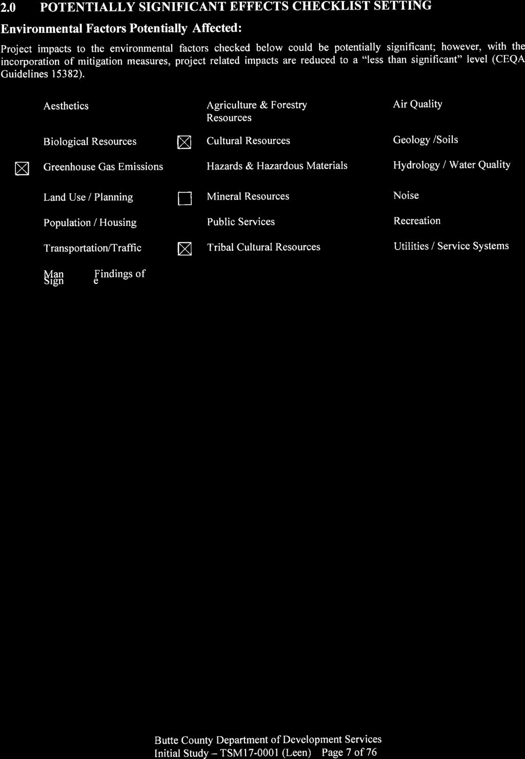
3 Department of Development Services Tim Snellings, Director Pete Calarco, Assistant Director
|
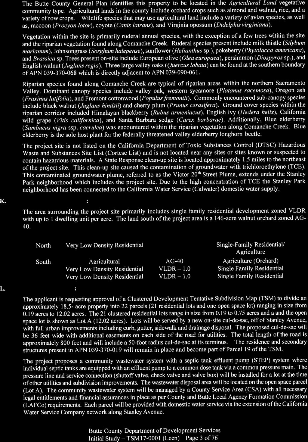
|
|
- Franklin Conley
- 5 years ago
- Views:
Transcription

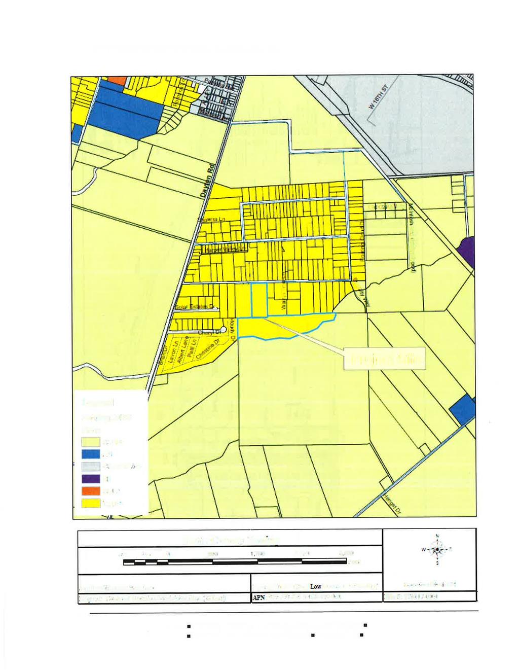
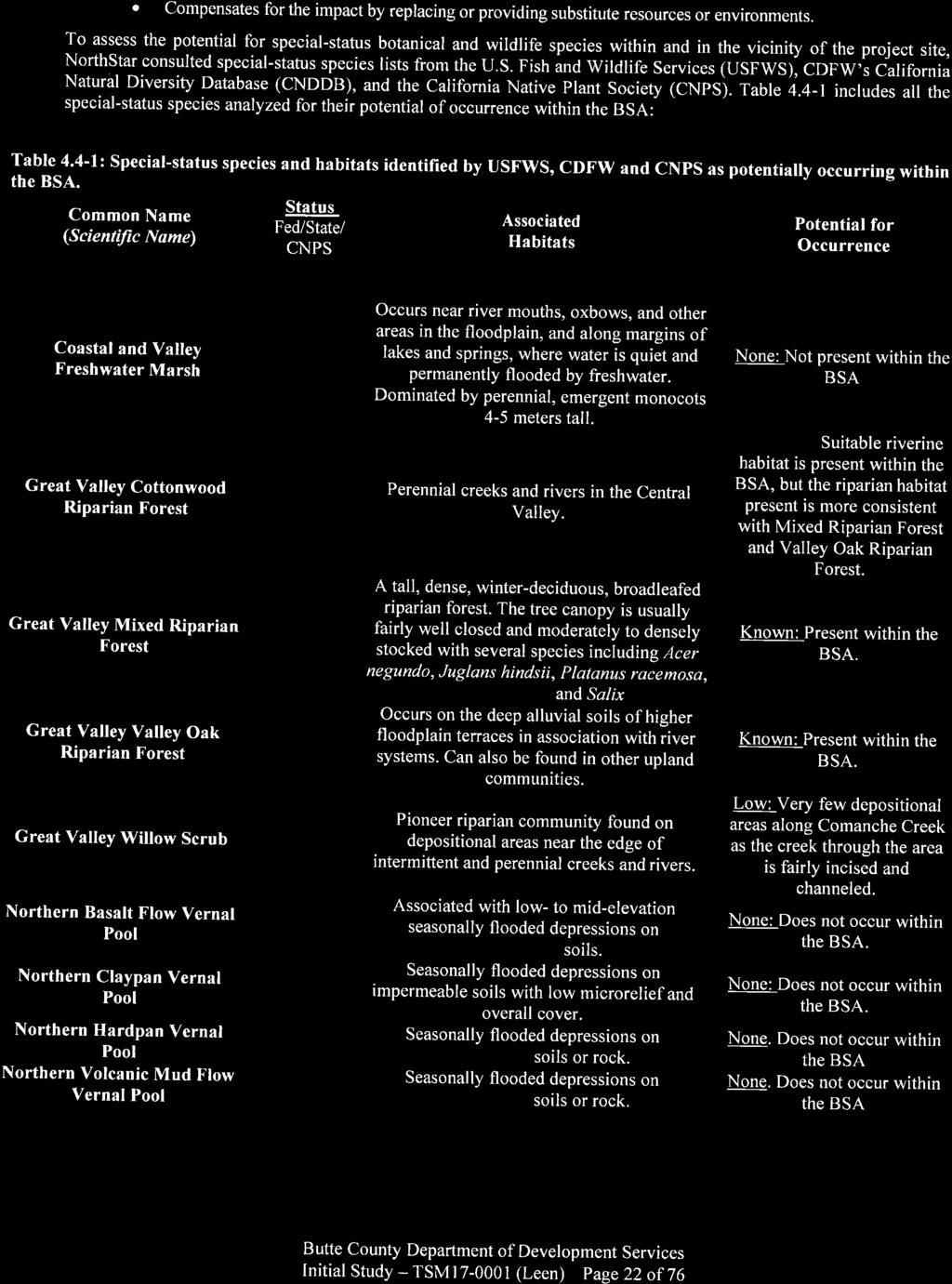
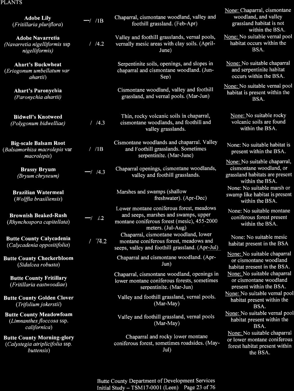
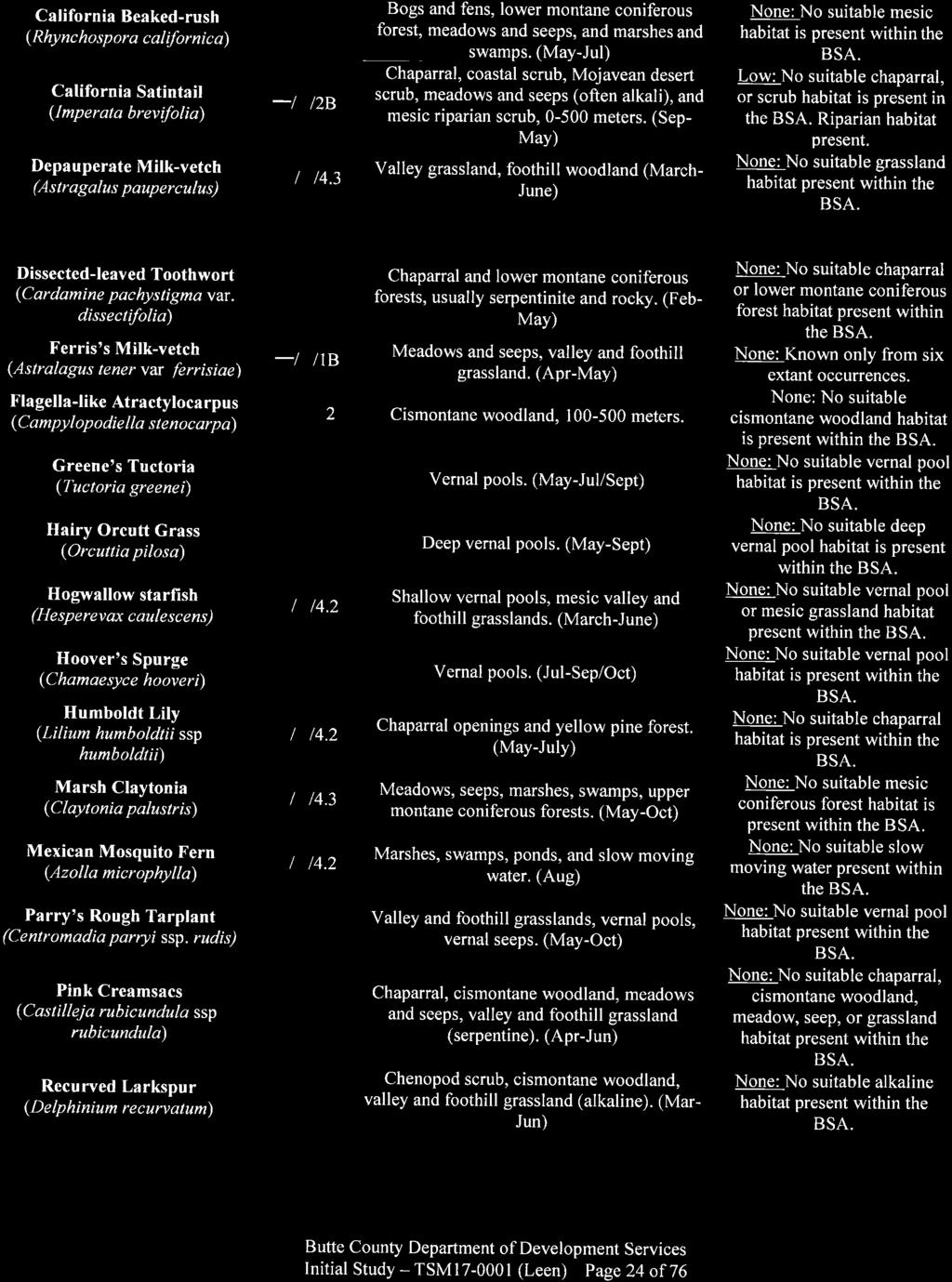
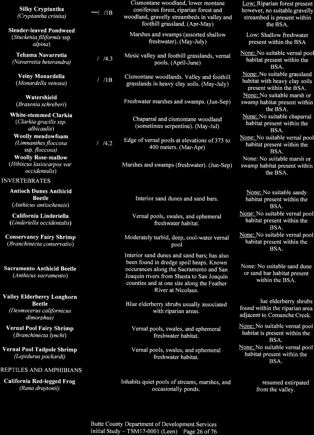
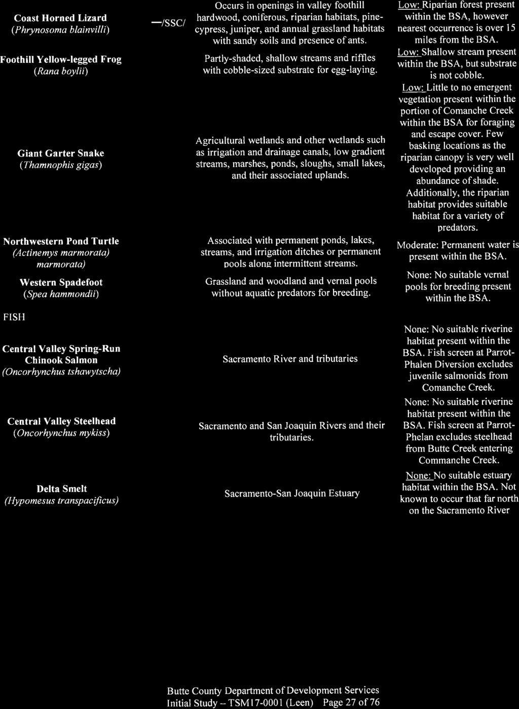
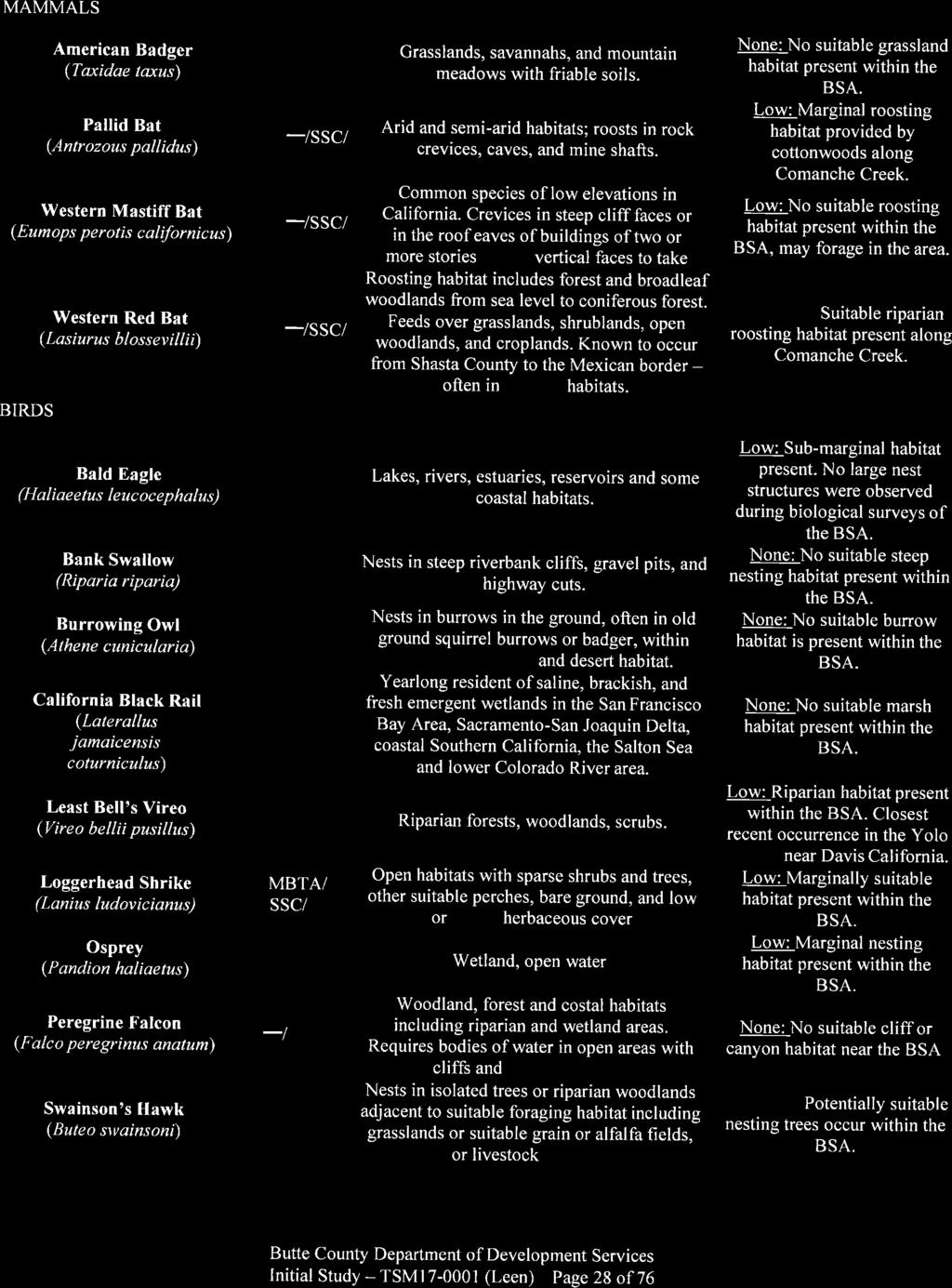
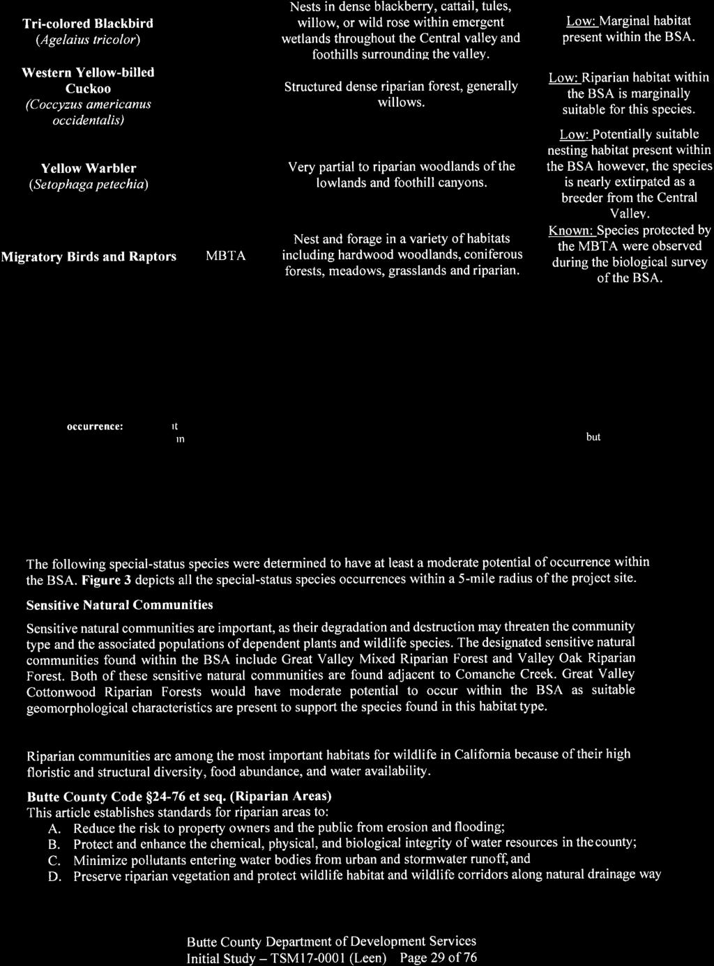
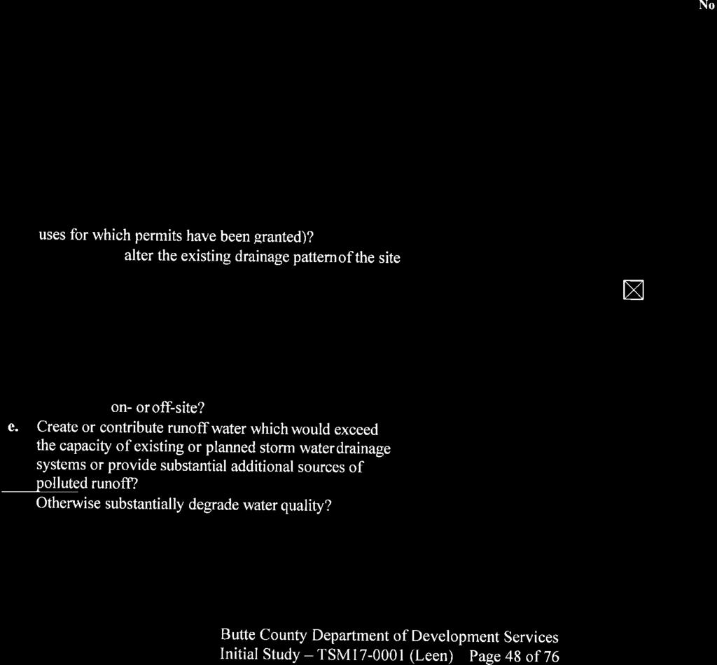
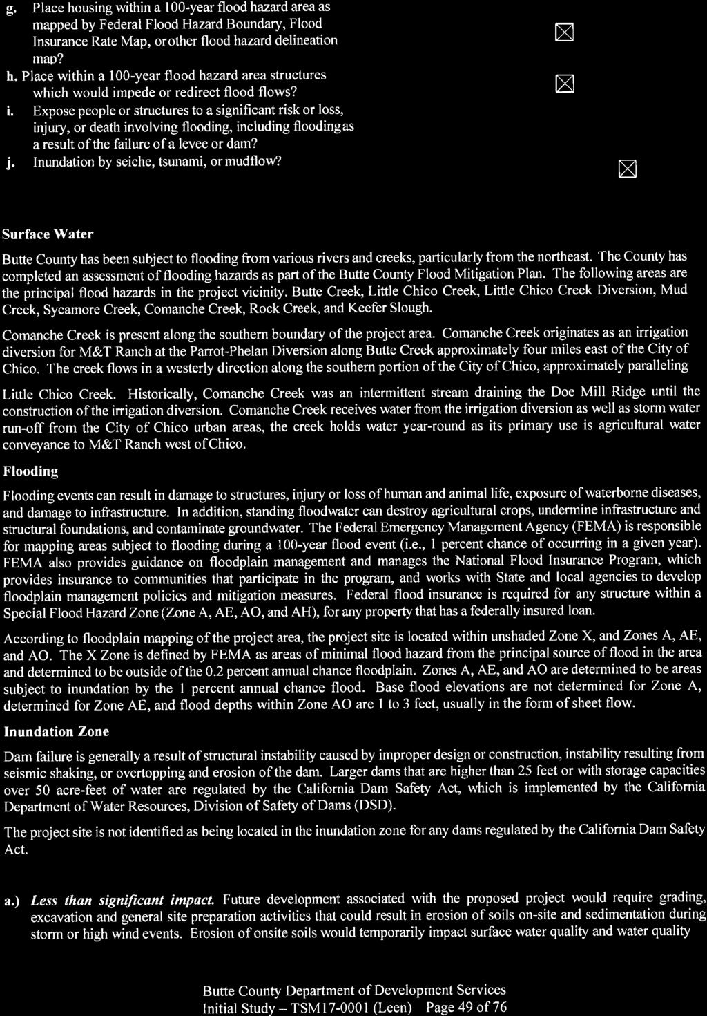
1 3 Department of Development Services Tim Snellings, Director Pete Calarco, Assistant Director 7 County Center Drive T: Oroville, California F: buttecounty.net/dds BUTTE COUNTY PLANNING COMMISSION NOTICE OF INTENT TO ADOPT A MITIGATED NEGATIVE DECLARATION AND NOTICE OF PUBLIC HEARING FOR TENTATIVE SUBDIVISION MAP TSM17-1 NOTICE IS HEREBY GIVEN that the Butte County Planning Commission will hold a public hearing to consider an application for Tentative Subdivision Map TSM17-1 (Nels Leen) on July 26, 218, at 9: a.m. or shortly thereafter, in the Butte County Board of Supervisors Room, County Administration Center, 25 County Center Drive, Oroville, California as follows: Project Information: Project: Tentative Subdivision Map TSM17-1 APN: & Location: The project site is located at 1232 Stanley Avenue, on the south side of Stanley Avenue, ¼ mile east from Dayton Road, south of the City of Chico. Proposal: The applicant is requesting approval of a Clustered Tentative Subdivision Map (TSM) to divide an approximately 18.5 acre property (two parcels) into 22 parcels (21 residential lots and one open space lot) ranging in size from.19 acres to 12.2 acres. The 21 clustered residential lots range in size from.19 acres to.75 acres. The proposed open space parcel, Lot A, is approximately 12.2 aces). Lots will be served by a new cul-de-sac, off of Stanley Avenue, with full urban improvements including curb, gutter, sidewalk and drainage disposal. The project proposes a community waste water system, with individual septic systems and a community wastewater area. Each parcel will be provided with domestic water service via the extension of the California Water Service Company network along Stanley Avenue. The project proposes a 3 foot residential dwelling setback from the agriculturally zoned parcels to the south. Pursuant to Butte County Code (Residential Setback from Orchards and Vineyards), Development Services in consultation with the Agricultural Commissioner s Office has recommended a residential dwelling setback from adjacent active orchard (APN ) of either of 5 feet or 25 feet with an approved vegetation screen along the eastern property lines of parcels and from the northern property line of parcel 11. In compliance with CEQA, this notice discloses that there are no listed toxic sites present on site. A search of the state and federal agency databases for hazardous materials sites within one-mile of the project site was performed and the project site is within one-mile of an identified clean-up site. Diamond Match Factory, a State Response clean-up site, is located approximately.85 miles to the northeast of the project site. The Initial Study/Mitigated Negative Declaration (IS/MND) and reference documents for these projects are on file for public review and comment starting Tuesday, June 26, 218 through Wednesday, July 25, 218, at the Butte County Planning Division, 7 County Center Drive, Oroville, CA. The IS/MND is also available for review on the County website at All persons are invited to review the documents. Comments may be submitted to the Planning Division in writing at the above address at any time prior to the hearing or orally at the meeting listed above, or as may be continued to a later date. If you challenge the above application in court, you may be limited to raising only those issues you or someone else raised at the public hearing or in written correspondence delivered to the Planning Commission at, or prior to the public hearing. For information call or send an to Mark Michelena, Senior Planner, Butte County Development Services Department, Planning Division at (53) or mmichelena@buttecounty.net. In compliance with the Americans with Disabilities Act, if you need special assistance to participate in the hearing, please contact us at (53) Notification at least 72 hours prior to the hearing will enable staff to make reasonable arrangements. BUTTE COUNTY PLANNING COMMISSION TIM SNELLINGS, DIRECTOR OF DEVELOPMENT SERVICES
2
3
4
5

6
7
8
9
10
11
12
13
14
15
16
17
18
19
20
21
22
23
24
25
26
27
28
29
30
31
32
33
34

35
36
37
38
39
40
41
42
43
44
45
46
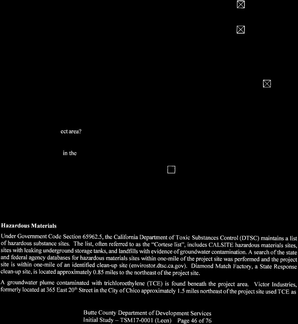
47
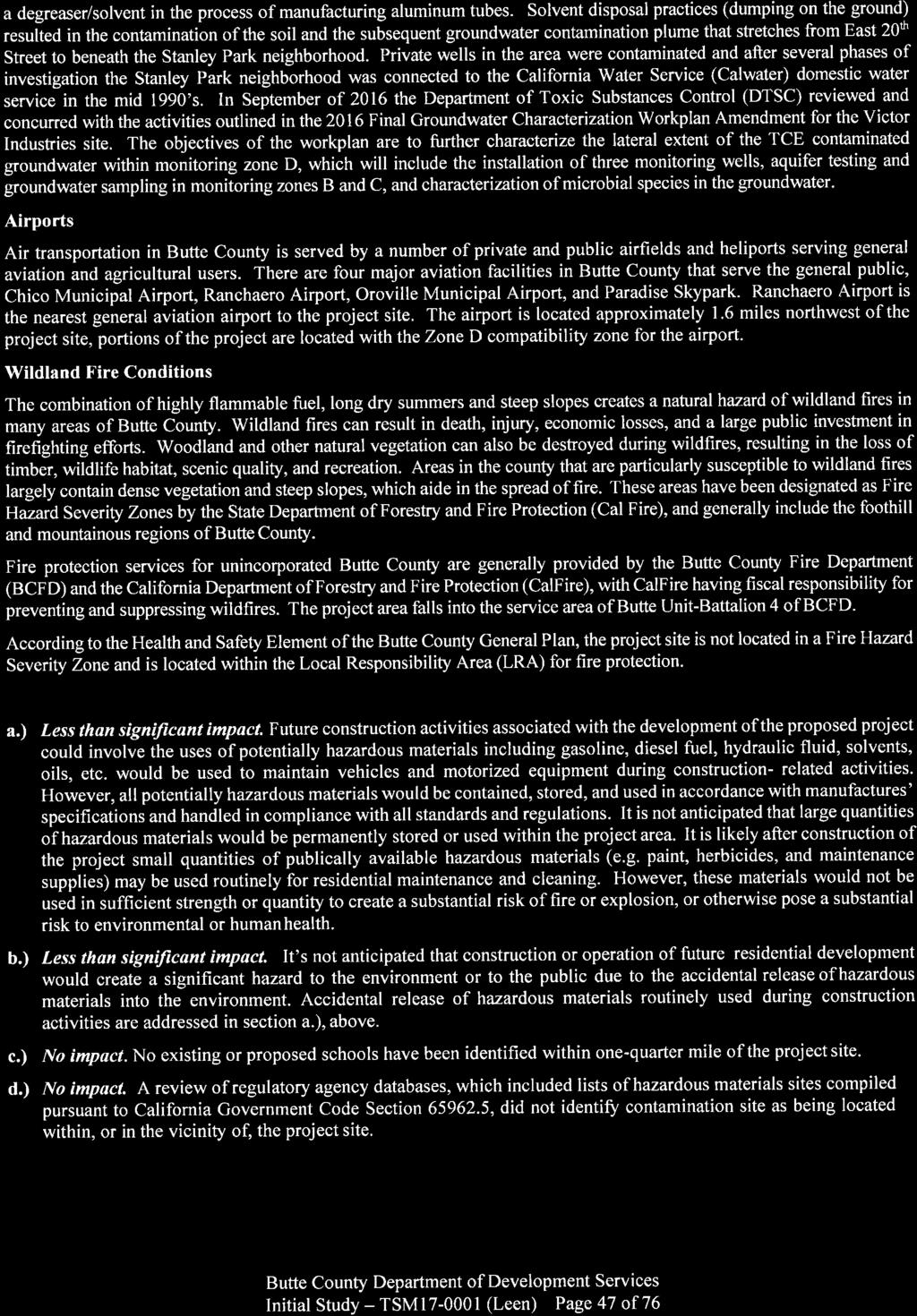
48
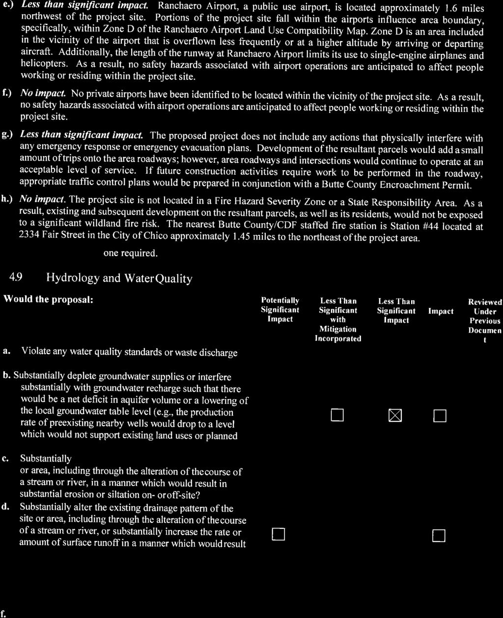
49
50
51
52
53
54
55

56
57
58
59
60
61
62
63
64
65
66
67
68
69
70
71
72
73
74
75
76
77
78
79

80
81 TRAFFIC IMPACT STUDY for Leen Subdivision February 2, 218 PREPARED FOR: Nels Leen & Associates PREPARED BY: DRAFT TRAFFIC WORKS, LLC 224 St. George Ln, Suite 1, Chico, CA
82 Traffic Impact Study Leen Subdivision February 2, 218 Why did you perform this study? YOUR QUESTIONS ANSWERED QUICKLY This Traffic Impact Study evaluates the potential traffic impacts associated with the proposed Leen Subdivision project. This study of potential transportation impacts was undertaken for community planning and CEQA review purposes and to determine what traffic controls or other mitigations may be needed to reduce potential impacts, if any are identified. What does the project consist of? The proposed project is a 21 unit single family detached housing subdivision. The site is located on the south side of Stanley Avenue east of the Dayton Road / Stanley Avenue intersection in Butte County, CA. How much traffic will the project generate? The Leen Subdivision project is anticipated to generate 198 Daily trips, 16 AM peak hour trips, and 21 PM peak hour trips. Are there any traffic impacts? With the addition of project traffic, the Dayton Road/Stanley Avenue intersection is projected to operate at acceptable level of service conditions (LOS B or better) under Existing Plus Project conditions during both the AM and PM peak hours. Additionally, Stanley Lane and the Stanley Lane/Street A project intersection will operate at acceptable level of service conditions (LOS A ) under Existing Plus Project conditions. No notable traffic operation impacts are anticipated with the project. Are any improvements recommended? Stanley Avenue has a relatively narrow paved width (16 feet at the narrowest but typically 17 to 18 feet) which is less than the 2 foot minimum roadway width recommended in A Policy on Geometric Design of Highways and Streets (24) published by the American Association of State Highway and Transportation Officials (AASHTO) and narrower than Butte County standards for new County roadways. To provide a safe and efficient roadway with increased traffic, the applicant will provide a proportionate cost sharing contribution for widening of the pavement section on Stanley Avenue to a 2 foot width from Dayton Road to the project entry point. If the County requests the applicant to physically construct widening improvements in an dollar amount equal to the proportionate share, in lieu of paying the fee, it is our recommendation that the widen begin at Dayton Road and move east to the extent possible with the fee amount. The greatest widening benefit will be realized where traffic volumes are the highest, which is closest to Dayton Road. Page 1 of 13
83 Traffic Impact Study Leen Subdivision February 2, 218 LIST OF FIGURES 1. Study Area 2. Site Plan 3. Existing Traffic Volumes, Lane Configurations, and Controls 4. Project Trips 5. Existing Plus Project Traffic Volumes, Lane Configurations, and Controls LIST OF APPENDICES A. Traffic Volume Data B. Existing Conditions LOS Calculations C. Existing Plus Project Conditions LOS Calculations Page 2 of 13
84 Traffic Impact Study Leen Subdivision February 2, 218 INTRODUCTION This report presents the findings of a Traffic Impact Study completed to assess the potential impacts on local roadways and intersections associated with development of the Leen Subdivision project. This Traffic Impact Study has been prepared to describe existing traffic conditions, quantify traffic volumes generated by the proposed project, identify potential impacts on all modes of travel, document findings, and make recommendations to mitigate impacts, if any are found. Study Area and Evaluated Scenarios The project is generally located on Stanley Avenue east of the Dayton Road / Stanley Avenue intersection in Butte County, CA. The following intersections and roadway segment were analyzed based on scoping discussions and correspondence with Butte County staff: Dayton Road / Stanley Avenue Stanley Avenue / Street A (project access) Stanley Avenue roadway segment Dayton Road to the project site The locations of these intersections and the study roadway segment are shown on Figure 1 and the project site plan is provided in Figure 2. This study includes analysis of both the weekday AM and PM peak hours as these are the periods of time in which peak traffic conditions are anticipated to occur. The evaluated development scenarios are: Existing Conditions (no project) Existing Plus Project Conditions Analysis Methodology Level of service (LOS) is a term commonly used by transportation practitioners to measure and describe the operational characteristics of intersections, roadway segments, and other facilities. This term equates seconds of delay per vehicle at intersections to letter grades A through F with A representing optimum conditions and F representing breakdown or over capacity flows. The LOS for a Two Way STOP Control (TWSC) intersection is defined by the worst movement delay. Signal and All Way STOP Control (AWSC) LOS is reported for the overall intersection. The complete methodology is established in the Highway Capacity Manual (HCM), 21, published by the Transportation Research Board. Table 1 presents the delay thresholds for each level of service grade at un signalized and signalized intersections. Level of service calculations were performed for the study intersections using the Vistro 5. software package with analysis and results reported in accordance with the 21 HCM methodology. Page 3 of 13
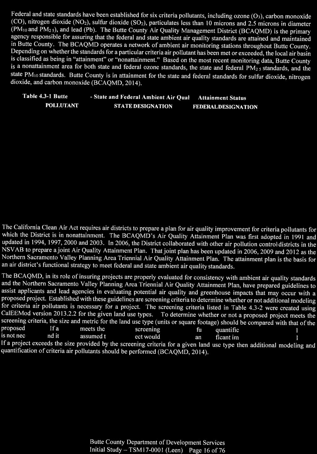
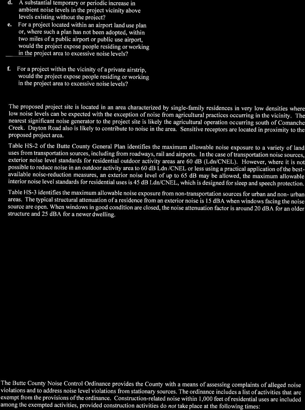
85 Traffic Impact Study Leen Subdivision February 2, 218 Level of Service Table 1: Level of Service Definition for Intersections Brief Description Un signalized Intersections (average delay/vehicle in seconds) Signalized Intersections (average delay/vehicle in seconds) A Free flow conditions. < 1 < 1 B Stable conditions with some 1 to 15 1 to 2 affect from other vehicles. C Stable conditions with 15 to 25 2 to 35 significant affect from other vehicles. D High density traffic conditions 25 to to 55 still with stable flow. E At or near capacity flows. 35 to 5 55 to 8 F Over capacity conditions. > 5 > 8 Source: Highway Capacity Manual (21), Chapters 16 and 17 The criteria for evaluating roadway LOS is outlined in the Butte County General Plan 23. For the roadway segment LOS calculations, roadway capacity is determined by facility type, as shown in Table 2, and roadway volume based on peak hour segment volume. Roadway LOS was determined by comparing the observed and projected peak hour bi directional roadway volumes to the volumes shown in Table 2. Table 2: Level of Service Criteria for Roadway Segments Facility Type Peak Hour LOS Capacity Threshold A B C D E Minor 2 lane Hwy ,41 1,74 Major 2 lane Hwy/Exp ,6 2,5 4 lane, Multi lane Hwy/Exp 1,7 1,76 2,53 3,28 3,65 2 lane Major Arterial 97 1,76 1,87 4 lane Major Arterial, Undivided 1,75 2,74 2,89 4 lane Major Arterial, Divided 1,92 3,54 3,74 6 lane Arterial, Divided 2,71 5,32 5,6 3 lane Arterial, One way Rd 131 2,6 2,17 2 lane Freeway 1,11 2,1 2,88 3,57 4,1 2 lane Freeway + Aux Lane 1,41 2,55 3,64 4,49 5,35 3 lane Freeway 1,7 3,8 4,4 5,41 6,6 3 lane Freeway + Aux Lane 2,1 3,64 5,18 6,35 7,1 4 lane Freeway 2,32 4,2 5,95 7,28 8,14 Major 2 lane Collector 55 1,18 1,52 * Source: Highway Capacity Manual 2. Transportation Research Board, Washington, D.C. *Retrieved from Butte County General Plan 23. Table CIR-2, pg Page 4 of 13

86 Traffic Impact Study Leen Subdivision February 2, 218 Level of Service Policy Butte County established county wide level of service criteria standards and thresholds in the Butte County General Plan 23. Circulation Policy CIR P6.1 is most applicable to this project location. Therefore, the trigger requiring traffic mitigation is crossing the threshold between LOS C and LOS D. EXISTING TRANSPORTATION FACILITIES Roadway Facilities A brief description of the key roadways in the study area is provided below. Dayton Road within the project area is a two lane roadway running generally north south with one lane in each direction. It is classified as a Major Roadway according to the Butte County General Plan 23 (Figure CIR 1). The City of Chico General Plan classifies Dayton Road as a Major Arterial. The posted speed limit is 45 miles per hour (mph) within the study area. Stanley Avenue is an east west local roadway. The typical roadway width is 17.5 feet between Dayton Road and the project site with the narrowest measured width at 16 feet. It is classified as a Local Road in the Butte County General Plan 23. The posted speed limit is 25 mph. Alternative Travel Mode Facilities No sidewalks or bicycle lanes are present on any of the roadways in the study area. There are approximately three to five foot wide paved shoulders on both sides of Dayton Road in the study area. Currently there are no fixed route public transit services (B Line) available within the project area. The project location is semi rural and therefore very few walking or biking trips are currently made from the existing neighborhood to the City of Chico urbanized area primarily due to the travel distance and secondarily because the connecting facilities have limited pedestrian or bicycle facilities. Page 5 of 13
87 Traffic Impact Study Leen Subdivision February 2, 218 EXISTING CONDITIONS Existing Traffic Volumes Existing traffic volumes were determined by collecting new turning movement counts during the AM and PM peak periods at the Dayton Road / Stanley Avenue intersection and 24 hour roadway traffic volumes on Stanley Avenue on an average mid week day in January 218 with local schools and Chico State University in regular session. Existing intersection lane configurations, controls, and peak hour traffic volumes are shown in Figure 3, attached, and 24 hour roadway segment volumes are shown graphically in Exhibit 1. Exhibit 1. Hourly Roadway Volumes on Stanley Avenue # of Vehicles AM Peak Hour, 36 PM Peak Hour, 46 Time Westbound Volume Eastbound Volume Total Volume As shown in Exhibit 1, the AM and PM peak hour traffic volumes on Stanley Avenue are 36 and 46 vehicles, respectively. In total, there were 424 vehicles counted on Stanley Avenue during the mid week 24 hour period. Complete 24 hour roadway count data with volume, classification, and speed information is provided in Appendix A. Page 6 of 13
88 Traffic Impact Study Leen Subdivision February 2, 218 Existing Roadway Level of Service Roadway Level of Service was determined by comparing existing peak hour bi directional roadway segment volumes to the thresholds shown in Table 2. The Stanley Avenue roadway segment Level of Service is shown in Table 3. Table 3: Existing Conditions Roadway Level of Service Summary Segment Classification Scenario Peak Hour Volume # of Lanes LOS Stanley Ave 2 Lane Local Road Existing 46 2 A As shown in Table 4, the Stanley Avenue roadway segment is operating at acceptable LOS A conditions during the peak hour. The peak hour volume on Stanley Avenue is extremely low and is approximately 1/1 th of the volume needed to reach the LOS C threshold in Table 2. The roadway has significant surplus capacity. Existing Intersection Level of Service Analysis Intersection Level of service calculations were performed using the existing traffic volumes, lane configurations, and traffic controls. The results are presented in Table 4 and the calculation sheets are provided in Appendix B, attached. Table 4: Existing Conditions Intersection Level of Service Summary Existing AM Existing PM Intersection Control Delay 1 LOS Delay 1 LOS Dayton Road / Stanley Ave Side Street Westbound Approach A 9.9 B STOP Southbound Left A 7.62 A 8.25 Notes: 1. Delay is reported in seconds per vehicle for the overall intersection for signalized intersections, and for the worst approaches/movements for side street stop controlled intersections. As shown in Table 4, the existing study intersection currently operates at acceptable levels of service (LOS B or better). Intersection Sight Distance An intersection sight distance evaluation was performed for the side street (westbound) approach of the Dayton Road / Stanley Avenue intersection. No significant issues were identified as the sight distances were deemed to be essentially unlimited from the appropriate location 14 feet back from the edge of travel way in accordance with nationally accepted sight distance measurement criteria (A Policy on Geometric Design of Highways and Streets (24) published by the American Association of State Highway and Transportation Officials (AASHTO)). Page 7 of 13
89 Traffic Impact Study Leen Subdivision February 2, 218 It is important to note that further vegetation growth adjacent to the sight lines looking in both directions (north and south) could impact the current available sight distance in the future. Butte County and adjacent property owners, as appropriate, should remove the vegetation potentially affecting sight lines on a regular basis to insure adequate intersection sight distance is maintained. No design feature or geometric changes are needed at the Dayton Road/Stanley Avenue intersection. PROPOSED PROJECT Project Description The project site is located on two existing contiguous parcels with direct access to the south side of Stanley Avenue approximately 1,5 feet east of Dayton Road. The proposed project consists of 21 residential lots and Lot A which is to be preserved as Open Space pursuant to the Clustered Development Ordinance. Parking The project will provide on site parking in accordance with Butte County development standards. Trip Generation Trip generation rates for the proposed project were obtained from the Trip Generation Manual, 1th Edition, published by the Institute of Transportation Engineers (ITE). Table 5 provides the Daily, AM Peak Hour, and PM Peak Hour trip generation calculations for the proposed project. Table 5: Trip Generation Estimates Land Use (#) Size Daily Single Family Detached Housing (21) 21 Dwelling Units A.M. Peak P.M. Peak Total Entry Exit Total Entry Exit Notes: ITE 1th Ed. Trip Generation Rates For Single Family Detached Housing (Per Dwelling) Daily: 9.44, AM:.74, PM:.99 As shown in Table 5, applying the ITE Trip Generation Manual trip rates, the proposed project is anticipated to generate 198 total daily trips, 16 total AM peak hour trips, and 21 total PM peak hour trips. Vehicle Miles Travelled (VMT) Estimation With adoption of and implementation of California Senate Bill 743, Vehicle Miles Travelled (VMT) is an important consideration and a key metric of vehicular travel contributions to Green House Gas (GHG) emissions and energy consumption. VMT is typically expressed in miles per day and can simplistically be calculated by multiplying the number of daily project generated trips by the anticipated trip length. The average trip length and percentage of each type of home based trip in Butte County was obtained from the California Emissions Estimator Model (CalEEMod). Table 6 shows each home based trip type and the associated average trip length in Butte County. Page 8 of 13
90 Traffic Impact Study Leen Subdivision February 2, 218 Res H W Trip Length (miles) Res H S Trip Length (miles) Table 6. Project Vehicle Miles Travelled Res H O Trip Length (miles) Res H W Trip % Res H S Trip % Res H O Trip % Average Trip Length (miles) Total VMT per day (198 Trips) ,798 As shown in Table 6, the project is estimated to cause an increase in VMT of 1,798 miles per day. This is likely a very conservative estimate since the project is located closer to the core urban area than the Butte County average travel distances. Butte County currently does not have any specific thresholds or significance criteria related to VMT, but does have general goals of reducing VMT and GHG emissions. Project Access One access point is proposed for the project, located on Stanley Avenue, as shown on Figure 2. The access point is proposed as a full access intersection allowing for all possible movements with side street stop control (STOP sign on Street A). We understand secondary access is not required per Butte County standards based on the relatively small number of proposed homes and the proposed street design. Field review of the access location indicated no notable issues for intersection sight distance. Adjacent parcels have large trees and other shrubs along Stanley Avenue but they are not anticipated to impact intersection sight distance at this time. As is common in most locations, vegetation along Stanley Avenue may have to be trimmed and properly maintained over time to maintain appropriate sight lines. Trip Distribution and Assignment Traffic generated by the project was distributed to the road network based on the location of the project and for consistency with existing local traffic patterns. The following trip distribution percentages were used for distributing the project traffic: 75% travelling to/from the north via Dayton Road 25% travelling to/from the south via Dayton Road 1% of the project generated trips were assigned to/from the west on Stanley Avenue from the project site. A time travel comparison was conducted to compare the difference in travel time drivers would experience if they travelled either east or west from the site ultimately to Dayton Road. The travel time east through the neighborhood, using Diamond Avenue and McIntosh Avenue, was found to be twice that of simply using Stanley Avenue to Dayton Road. No notable number of drivers would choose a route that is twice as time consuming to reach the same destination. Review of the roadway network indicates that project traffic would not use Marian Avenue as there would be no benefit in doing so. It is clear that all project traffic should be assumed to choose the most direct route of Stanley Avenue to/from the west to Dayton Road. Page 9 of 13
91 Traffic Impact Study Leen Subdivision February 2, 218 The Existing Plus Project intersection lane configurations and the project trip assignment are shown on Figure 4, attached. EXISTING PLUS PROJECT CONDITIONS Existing Plus Project Roadway Level of Service Roadway Level of Service was calculated by comparing existing plus project peak hour bi directional roadway segment volumes to the thresholds shown in Table 2. The Stanley Avenue roadway segment Level of Service is shown in Table 7. Table 7: Existing Plus Project Conditions Roadway Level of Service Summary Segment Classification Scenario Peak Hour Volume # of Lanes LOS Stanley Ave 2 Lane Local Road Existing Plus Project 67 2 A As shown in Table 7, the Stanley Avenue roadway segment is anticipated to operate at acceptable level of service (LOS A ) conditions during the peak hour. The proposed project only adds 21 peak hour trips on Stanley Avenue and the roadway peak hour volume is still extremely low. The anticipated average daily traffic volume (ADT) under Existing Plus Project conditions is 622 vehicles per day. Existing Plus Project Intersection Level of Service Analysis Existing Plus Project traffic volumes were developed by adding the project generated trips (Figure 4) to the existing traffic volumes (Figure 3) and are shown on Figure 5, attached. Existing Plus Project condition Peak Hour Factors (PHF) and lane configurations were assumed to remain the same as existing conditions. Table 8 presents the level of service analysis summary for the Existing Plus Project scenario. Detailed calculation sheets are provided in Appendix C, attached. Table 8: Existing Plus Project Conditions Intersection Level of Service Summary Existing + Project AM Existing + Project PM Intersection Control Delay 1 LOS Delay 1 LOS Dayton Road / Stanley Ave Side Street Westbound Approach B 1. B STOP Southbound Left A 7.63 A 8.3 Stanley Ave / Street A Side Street Northbound Approach A 8.77 A 8.78 STOP Westbound Left A 7.23 A 7.3 Notes: 1. Delay is reported in seconds per vehicle for the overall intersection for signalized intersections, and for the worst approaches/movements for side street stop controlled intersections. With the addition of project traffic, both study intersections are projected to operate at acceptable level of service (LOS B or better) conditions during both the AM and PM peak hours. The proposed project would, on average, increase delay by less than one second per vehicle during the peak hours. Page 1 of 13
92 Traffic Impact Study Leen Subdivision February 2, 218 ROADWAY WIDTH Stanley Avenue has a relatively narrow paved width (16 feet at the narrowest but typically 17 to 18 feet) which is less than the 2 foot roadway width recommended in A Policy on Geometric Design of Highways and Streets (24) published by the American Association of State Highway and Transportation Officials (AASHTO). The existing roadway is also narrower than Butte County standards for new construction within the County. Table 9 shows the recommended minimum width of traveled way, by roadway volume, for rural crosssections as set forth by AASHTO. Table 8. Minimum Width of Traveled Way (AASHTO Exhibit 5 5) Design Speed (mph) Minimum width of traveled way (ft) for specified design volume (veh/day) under 4 4 to to 2 over Width of graded shoulder on each side of the road (ft) All Speeds As highlighted in Table 9, the minimum width of traveled way (paved width) on Stanley Avenue should be 2 feet. This value is the same with or without the project since the existing daily traffic volume is greater than 4 vehicles per day. From the parcel lines shown in the Butte County Online GIS program, there should be available right ofway to widen Stanley Avenue to meet AASHTO recommendations. This improvement may, however, restrict the informal parking that currently occurs on the shoulders along Stanley Avenue. The residential lots fronting Stanley Avenue are generally large with space to park more than two vehicles off street, therefore prohibiting parking along the widened roadway should not cause any significant parking impacts. Page 11 of 13
93 Traffic Impact Study Leen Subdivision February 2, 218 To provide a safe and efficient roadway with increased traffic, the applicant will provide a proportionate cost sharing contribution for widening of the pavement section on Stanley Avenue to a 2 foot width from Dayton Road to the project entry point. If the County requests the applicant to physically construct widening improvements in an dollar amount equal to the proportionate share, in lieu of paying the fee, it is our recommendation that the widen begin at Dayton Road and move east to the extent possible with the fee amount. The greatest widening benefit will be realized where traffic volumes are the highest, which is closest to Dayton Road. With proportionate cost sharing for the widening, or by constructing equal value widening improvements, the project will offset/mitigate its impacts of increased traffic related to the width of Stanley Avenue. The California Manual on Uniform Traffic Control Devices (CA MUTCD) states that Center line markings should be placed on all rural arterials and collectors that have a traveled way of 18 feet or more in width and an ADT of 3, vehicles per day or greater. Center line markings should also be placed on other traveled ways where an engineering study indicates such a need. The ADT on Stanley Avenue is well under 3, vehicles per day (622 ADT with the project) and we did not identify any special circumstances (horizontal or vertical curves, unusual conditions, etc.), therefore centerline striping is not justified at this time. CONCLUSIONS & RECOMMENDATIONS The following is a list of our key findings and recommendations: Proposed Project: The project is a 21 unit single family detached housing subdivision. The project site is generally located on the south side of Stanley Avenue about 1,5 feet east of the Dayton Road / Stanley Avenue intersection in Butte County, CA. Project Trips: The Leen Subdivision project is anticipated to generate 198 Daily trips, 16 AM peak hour trips, and 21 PM peak hour trips. Project Access: One access point is proposed for the project, located on Stanley Avenue, as shown on Figure 2. The access point is proposed as a full access intersection allowing for all possible movements with side street stop control. Existing Level of Service: All study intersections and roadway segments currently operate at acceptable level of service conditions (LOS B or better) during the AM and PM peak hours. Existing Plus Project Level of Service: With the addition of project traffic, all study intersections and roadway segments are projected to continue operating at acceptable LOS conditions (LOS B or better) under the Existing Plus Project conditions during both the AM and PM peak hours. The project would have no notable operational impacts on local intersections or roadway segments. Page 12 of 13
94 Traffic Impact Study Leen Subdivision February 2, 218 Summary of Proposed Improvements: To provide a safe and efficient roadway cross section on Stanley Avenue with increased traffic, the applicant will provide a proportionate cost sharing contribution for widening of the pavement section to a 2 foot width from Dayton Road to the project entry point. If the County requests the applicant to physically construct widening improvements in an dollar amount equal to the proportionate share, in lieu of paying the fee, it is our recommendation that the widen begin at Dayton Road and move east to the extent possible with the fee amount. The greatest widening benefit will be realized where traffic volumes are the highest, which is closest to Dayton Road. With proportionate cost sharing for the widening, or by constructing equal value widening improvements, the project will offset/mitigate its impacts of increased traffic related to the width of Stanley Avenue. Page 13 of 13
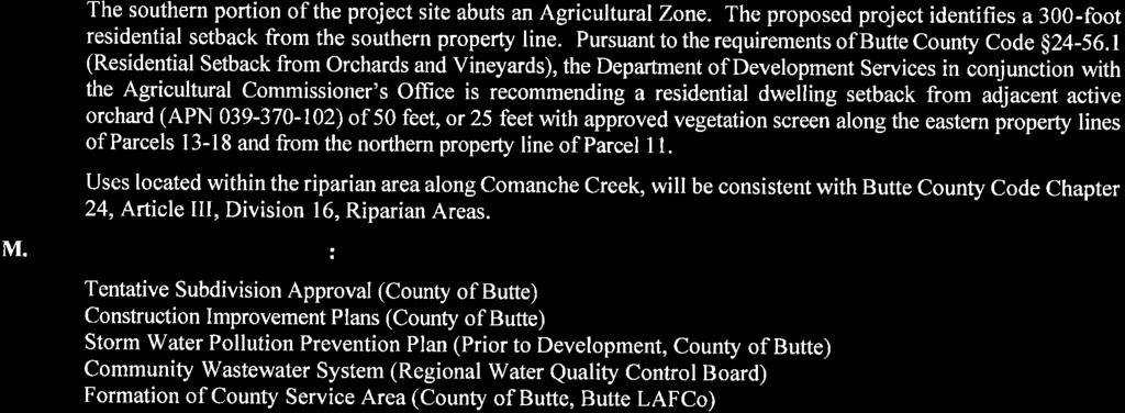
95 Study Locations 1 Dayton Rd / Stanley Ave 2 Stanley Ave / Street A Dayton Rd 1 Traffic Volume Count Location 2 Stanley Ave Street A Project Site NO SCALE Figure 1 Leen Subdivision Traffic Impact Study Study Area
96 PARCEL 1 8,913.2 SF.2 AC (.27 AC NET) PARCEL 21 8,512.4 SF.2 AC (.25 AC NET) PARCEL 2 8,939.1 SF.21 AC (.25 AC NET) PARCEL 2 9,23.4 SF.21 AC (.25 AC NET) PARCEL 3 8,965. SF.21 AC (.25 AC NET) PARCEL 4 8,99.9 SF.21 AC (.25 AC NET) PARCEL 19 26,763.6 SF.61 AC (.74 AC NET) PARCEL 5 9,16.8 SF.21 AC (.25 AC NET) PARCEL 18 9,549.3 SF.22 AC (.26 AC NET) PARCEL 6 9,165.1 SF.21 AC (.26 AC NET) PARCEL 17 9,528.4 SF.22 AC (.26 AC NET) PARCEL 7 9,191.7 SF.21 AC (.26 AC NET) PARCEL 16 9,57.4 SF.22 AC (.26 AC NET) PARCEL 8 9,218.4 SF.21 AC (.26 AC NET) PARCEL 15 9,486.4 SF.22 AC (.26 AC NET) PARCEL 9 9,244.9 SF.21 AC (.26 AC NET) PARCEL 14 9,465.4 SF.22 AC (.26 AC NET) WASTEWATER DISPOSAL AREA PARCEL 1 8,977.5 SF.21 AC (.27 AC NET) PARCEL 13 9,431.4 SF.22 AC (.27 AC NET) PARCEL 12 8,253.3 SF.19 AC (.23 AC NET) PARCEL 11 32,717.1 SF.75 AC (.77 AC NET) WASTEWATER DISPOSAL AREA LOT A 523,764.4 SF 12.2 AC (12.9 AC NET) Figure 2 Leen Subdivision Traffic Impact Study Site Plan
97 Dayton Rd 1 Stanley Ave Project Site Dayton Rd / Stanley Ave (167) 5 (14) 25 (1) 8 (2) (7) 177 (353) AM Peak Hour Volume (PM Peak Hour Volume) NO SCALE Figure 3 Leen Subdivision Traffic Impact Study Existing Traffic Volumes, Lane Configurations, and Controls
98 Dayton Rd 1 2 Stanley Ave Street A Project Site Dayton Rd / Stanley Ave Stanley Ave / Street A 1 3 (1) 2 9 (6) 3 (2) (13) 4 12 (8) 1 (3) NO SCALE AM Peak Hour Volume (PM Peak Hour Volume) Figure 4 Leen Subdivision Traffic Impact Study Project Trips
 NO SCALE AM Peak Hour Volume (PM Peak Hour Volume) Figure 5 Leen Subdivision Traffic Impact Study Existing Plus Project Traffic Volumes, Lane Configurations, and")
99 Dayton Rd 1 2 Stanley Ave Street A Project Site Dayton Rd / Stanley Ave Stanley Ave / Street A (167) 8 (24) 2 34 (16) 11 (4) (21) 5 (13) 4 33 (12) () () 12 (8) 1 (1) 177 (353) NO SCALE AM Peak Hour Volume (PM Peak Hour Volume) Figure 5 Leen Subdivision Traffic Impact Study Existing Plus Project Traffic Volumes, Lane Configurations, and Controls
100 Appendix A Traffic Volume Data
101 Printed: 2/1/218 at 9:18 TrafficViewer Pro v PicoCount 25 V2.3 (s/n# ) Daily Vehicle Volume Report Study Date: Unit ID: Location: Comments: Tuesday, 1/3/218 / Wednesday, 1/31/218 TW #5 Stanley Ave Westbound Volume Eastbound Volume Total Volume 16: - 16: : - 17: : - 18: : - 19: : - 2: : - 21: : - 22: : - 23: : - : : - 1: : - 2:59 3: - 3: : - 4: : - 5: : - 6: : - 7: : - 8: : - 9: : - 1: : - 11: : - 12: : - 13: : - 14: : - 15: Totals AM Peak Time 8:2-9:1 1:36-11:35 8:2-9:1 AM Peak Volume PM Peak Time 16:3-17:2 18:29-19:28 16: - 16:59 PM Peak Volume Counter_Data_File_Stanley_Ave.tvp Page 1
102 Printed: 2/1/218 at 9:18 TrafficViewer Pro v PicoCount 25 V2.3 (s/n# ) Daily Total Classes Report Study Date: Unit ID: Location: Comments: Tuesday, 1/3/218 / Wednesday, 1/31/218 TW #5 Stanley Ave 16: - 16:59 17: - 17:59 18: - 18:59 19: - 19:59 2: - 2:59 21: - 21:59 22: - 22:59 23: - 23:59 : - :59 1: - 1:59 2: - 2:59 3: - 3:59 4: - 4:59 5: - 5:59 6: - 6:59 7: - 7:59 8: - 8:59 9: - 9:59 1: - 1:59 11: - 11:59 12: - 12:59 13: - 13:59 14: - 14:59 15: - 15:59 Totals Percent of Total Percent of AM Percent of PM Truck Summary: #1 #2 #3 #4 #5 #6 #7 #8 #9 #1 #11 #12 #13 Total Total Trucks: 62 % Trucks: 14.6 AM % Trucks: 15.4 PM % Trucks: 14.3 Classification Scheme: FHWA (ID: 1) #1 #2 #3 #4 #5 Motorcycles - 2 Axles Passenger Cars - 2 Axles Pickup Trucks, Vans - 2 Axles Buses Single Unit - 2 Axles, 6 Tires #6 #7 #8 #9 #1 Single Unit Truck - 3 Axles Single Unit - 4 Axles Single Unit - 4 Axles or Less Double Unit - 5 Axles Double Unit - 6 Axles or More #11 #12 #13 Multi-Unit - 5 Axles or Less Multi-Unit - 6 Axles Multi-Unit - 7 Axles or More Counter_Data_File_Stanley_Ave.tvp Page 3
103 Printed: 2/1/218 at 9:18 TrafficViewer Pro v PicoCount 25 V2.3 (s/n# ) Daily Total Speeds (MPH) Study Date: Unit ID: Location: Comments: Tuesday, 1/3/218 / Wednesday, 1/31/218 TW #5 Stanley Ave Posted Speed: 25 16: - 16:59 17: - 17:59 18: - 18:59 19: - 19:59 2: - 2:59 21: - 21:59 22: - 22:59 23: - 23:59 : - :59 1: - 1:59 2: - 2:59 3: - 3:59 4: - 4:59 5: - 5:59 6: - 6:59 7: - 7:59 8: - 8:59 9: - 9:59 1: - 1:59 11: - 11:59 12: - 12:59 13: - 13:59 14: - 14:59 15: - 15:59 Totals Percent of Total Percent of AM Percent of PM Standard Deviation: Total MPH Ten Mile Pace: 2 to 29 MPH 85th Percentile: 31.3 MPH Mean Speed: Median Speed: Modal Speed: 24.6 MPH 25.1 MPH 27.5 MPH Percent in Ten Mile Pace: 61.3% 15th Percentile: 9th Percentile: 95th Percentile: 17.6 MPH 33.2 MPH 35.3 MPH Counter_Data_File_Stanley_Ave.tvp Page 3
104 Appendix B Existing Conditions LOS Calculations
105 Generated with Leen Subdivision TIA Version 5.- Existing AM LOS Control Type: Analysis Method: Analysis Period: Two-way stop HCM 6th Edition 15 minutes Intersection Level Of Service Report Intersection 1: Dayton Rd / Stanley Ave Delay (sec / veh): Level Of Service: Volume to Capacity (v/c): 11.2 B.15 Intersection Setup Name Dayton Rd Dayton Rd Stanley Ave Approach Northbound Southbound Westbound Lane Configuration Turning Movement Thru Right Left Thru Left Right Lane Width [ft] No. of Lanes in Pocket Pocket Length [ft] Speed [mph] Grade [%]... Crosswalk No No No Volumes Name Dayton Rd Dayton Rd Stanley Ave Base Volume Input [veh/h] Base Volume Adjustment Factor Heavy Vehicles Percentage [%] Growth Rate In-Process Volume [veh/h] Site-Generated Trips [veh/h] Diverted Trips [veh/h] Pass-by Trips [veh/h] Existing Site Adjustment Volume [veh/h] Other Volume [veh/h] Total Hourly Volume [veh/h] Peak Hour Factor Other Adjustment Factor Total 15-Minute Volume [veh/h] Total Analysis Volume [veh/h] Pedestrian Volume [ped/h]
106 Generated with Version 5.- Leen Subdivision TIA Existing AM LOS Intersection Settings Priority Scheme Free Free Stop Flared Lane No Storage Area [veh] Two-Stage Gap Acceptance No Number of Storage Spaces in Median Movement, Approach, & Intersection Results V/C, Movement V/C Ratio d_m, Delay for Movement [s/veh] Movement LOS A A A A B A 95th-Percentile Queue Length [veh] th-Percentile Queue Length [ft] d_a, Approach Delay [s/veh] Approach LOS A A A d_i, Intersection Delay [s/veh].93 Intersection LOS B
107 Generated with Leen Subdivision TIA Version 5.- Existing PM Control Type: Analysis Method: Analysis Period: Two-way stop HCM 6th Edition 15 minutes Intersection Level Of Service Report Intersection 1: Dayton Rd / Stanley Ave Delay (sec / veh): Level Of Service: Volume to Capacity (v/c): 13.8 B.5 Intersection Setup Name Dayton Rd Dayton Rd Stanley Ave Approach Northbound Southbound Westbound Lane Configuration Turning Movement Thru Right Left Thru Left Right Lane Width [ft] No. of Lanes in Pocket Pocket Length [ft] Speed [mph] Grade [%]... Crosswalk No No No Volumes Name Dayton Rd Dayton Rd Stanley Ave Base Volume Input [veh/h] Base Volume Adjustment Factor Heavy Vehicles Percentage [%] Growth Rate In-Process Volume [veh/h] Site-Generated Trips [veh/h] Diverted Trips [veh/h] Pass-by Trips [veh/h] Existing Site Adjustment Volume [veh/h] Other Volume [veh/h] Total Hourly Volume [veh/h] Peak Hour Factor Other Adjustment Factor Total 15-Minute Volume [veh/h] Total Analysis Volume [veh/h] Pedestrian Volume [ped/h]
108 Generated with Version 5.- Leen Subdivision TIA Existing PM Intersection Settings Priority Scheme Free Free Stop Flared Lane No Storage Area [veh] Two-Stage Gap Acceptance No Number of Storage Spaces in Median Movement, Approach, & Intersection Results V/C, Movement V/C Ratio d_m, Delay for Movement [s/veh] Movement LOS A A A A B B 95th-Percentile Queue Length [veh] th-Percentile Queue Length [ft] d_a, Approach Delay [s/veh] Approach LOS A A B d_i, Intersection Delay [s/veh].45 Intersection LOS B
109 Appendix C Existing Plus Project Conditions LOS Calculations
110 Generated with Leen Subdivision TIA Version 5.- Existing Plus Project AM LOS Control Type: Analysis Method: Analysis Period: Two-way stop HCM 6th Edition 15 minutes Intersection Level Of Service Report Intersection 1: Dayton Rd / Stanley Ave Delay (sec / veh): Level Of Service: Volume to Capacity (v/c): 11.3 B.2 Intersection Setup Name Dayton Rd Dayton Rd Stanley Ave Approach Northbound Southbound Westbound Lane Configuration Turning Movement Thru Right Left Thru Left Right Lane Width [ft] No. of Lanes in Pocket Pocket Length [ft] Speed [mph] Grade [%]... Crosswalk No No No Volumes Name Dayton Rd Dayton Rd Stanley Ave Base Volume Input [veh/h] Base Volume Adjustment Factor Heavy Vehicles Percentage [%] Growth Rate In-Process Volume [veh/h] Site-Generated Trips [veh/h] Diverted Trips [veh/h] Pass-by Trips [veh/h] Existing Site Adjustment Volume [veh/h] Other Volume [veh/h] Total Hourly Volume [veh/h] Peak Hour Factor Other Adjustment Factor Total 15-Minute Volume [veh/h] Total Analysis Volume [veh/h] Pedestrian Volume [ped/h]
111 Generated with Version 5.- Leen Subdivision TIA Existing Plus Project AM LOS Intersection Settings Priority Scheme Free Free Stop Flared Lane No Storage Area [veh] Two-Stage Gap Acceptance No Number of Storage Spaces in Median Movement, Approach, & Intersection Results V/C, Movement V/C Ratio d_m, Delay for Movement [s/veh] Movement LOS A A A A B A 95th-Percentile Queue Length [veh] th-Percentile Queue Length [ft] d_a, Approach Delay [s/veh] Approach LOS A A B d_i, Intersection Delay [s/veh] 1.26 Intersection LOS B
112 Generated with Leen Subdivision TIA Version 5.- Existing Plus Project AM LOS Control Type: Analysis Method: Analysis Period: Two-way stop HCM 6th Edition 15 minutes Intersection Level Of Service Report Intersection 2: Stanley Ave / Street A Delay (sec / veh): Level Of Service: Volume to Capacity (v/c): 8.8 A.13 Intersection Setup Name Street A Stanley Ave Stanley Ave Approach Northbound Eastbound Westbound Lane Configuration Turning Movement Left Right Thru Right Left Thru Lane Width [ft] No. of Lanes in Pocket Pocket Length [ft] Speed [mph] Grade [%]... Crosswalk No No No Volumes Name Street A Stanley Ave Stanley Ave Base Volume Input [veh/h] 5 33 Base Volume Adjustment Factor Heavy Vehicles Percentage [%] Growth Rate In-Process Volume [veh/h] Site-Generated Trips [veh/h] 12 4 Diverted Trips [veh/h] Pass-by Trips [veh/h] Existing Site Adjustment Volume [veh/h] Other Volume [veh/h] Total Hourly Volume [veh/h] Peak Hour Factor Other Adjustment Factor Total 15-Minute Volume [veh/h] Total Analysis Volume [veh/h] Pedestrian Volume [ped/h]
113 Generated with Version 5.- Leen Subdivision TIA Existing Plus Project AM LOS Intersection Settings Priority Scheme Stop Free Free Flared Lane No Storage Area [veh] Two-Stage Gap Acceptance No Number of Storage Spaces in Median Movement, Approach, & Intersection Results V/C, Movement V/C Ratio d_m, Delay for Movement [s/veh] Movement LOS A A A A A A 95th-Percentile Queue Length [veh] th-Percentile Queue Length [ft] d_a, Approach Delay [s/veh] Approach LOS A A A d_i, Intersection Delay [s/veh] 1.97 Intersection LOS A
114 Generated with Leen Subdivision TIA Version 5.- Existing Plus Project PM LOS Control Type: Analysis Method: Analysis Period: Two-way stop HCM 6th Edition 15 minutes Intersection Level Of Service Report Intersection 1: Dayton Rd / Stanley Ave Delay (sec / veh): Level Of Service: Volume to Capacity (v/c): 14.3 B.13 Intersection Setup Name Dayton Rd Dayton Rd Stanley Ave Approach Northbound Southbound Westbound Lane Configuration Turning Movement Thru Right Left Thru Left Right Lane Width [ft] No. of Lanes in Pocket Pocket Length [ft] Speed [mph] Grade [%]... Crosswalk No No No Volumes Name Dayton Rd Dayton Rd Stanley Ave Base Volume Input [veh/h] Base Volume Adjustment Factor Heavy Vehicles Percentage [%] Growth Rate In-Process Volume [veh/h] Site-Generated Trips [veh/h] Diverted Trips [veh/h] Pass-by Trips [veh/h] Existing Site Adjustment Volume [veh/h] Other Volume [veh/h] Total Hourly Volume [veh/h] Peak Hour Factor Other Adjustment Factor Total 15-Minute Volume [veh/h] Total Analysis Volume [veh/h] Pedestrian Volume [ped/h]
115 Generated with Version 5.- Leen Subdivision TIA Existing Plus Project PM LOS Intersection Settings Priority Scheme Free Free Stop Flared Lane No Storage Area [veh] Two-Stage Gap Acceptance No Number of Storage Spaces in Median Movement, Approach, & Intersection Results V/C, Movement V/C Ratio d_m, Delay for Movement [s/veh] Movement LOS A A A A B B 95th-Percentile Queue Length [veh] th-Percentile Queue Length [ft] d_a, Approach Delay [s/veh] Approach LOS A A B d_i, Intersection Delay [s/veh].75 Intersection LOS B
116 Generated with Leen Subdivision TIA Version 5.- Existing Plus Project PM LOS Control Type: Analysis Method: Analysis Period: Two-way stop HCM 6th Edition 15 minutes Intersection Level Of Service Report Intersection 2: Stanley Ave / Street A Delay (sec / veh): Level Of Service: Volume to Capacity (v/c): 8.8 A.1 Intersection Setup Name Street A Stanley Ave Stanley Ave Approach Northbound Eastbound Westbound Lane Configuration Turning Movement Left Right Thru Right Left Thru Lane Width [ft] No. of Lanes in Pocket Pocket Length [ft] Speed [mph] Grade [%]... Crosswalk No No No Volumes Name Street A Stanley Ave Stanley Ave Base Volume Input [veh/h] Base Volume Adjustment Factor Heavy Vehicles Percentage [%] Growth Rate In-Process Volume [veh/h] Site-Generated Trips [veh/h] 8 13 Diverted Trips [veh/h] Pass-by Trips [veh/h] Existing Site Adjustment Volume [veh/h] Other Volume [veh/h] Total Hourly Volume [veh/h] Peak Hour Factor Other Adjustment Factor Total 15-Minute Volume [veh/h] Total Analysis Volume [veh/h] Pedestrian Volume [ped/h]


117 Generated with Version 5.- Leen Subdivision TIA Existing Plus Project PM LOS Intersection Settings Priority Scheme Stop Free Free Flared Lane No Storage Area [veh] Two-Stage Gap Acceptance No Number of Storage Spaces in Median Movement, Approach, & Intersection Results V/C, Movement V/C Ratio d_m, Delay for Movement [s/veh] Movement LOS A A A A A A 95th-Percentile Queue Length [veh] th-Percentile Queue Length [ft] d_a, Approach Delay [s/veh] Approach LOS A A A d_i, Intersection Delay [s/veh] 1.33 Intersection LOS A
Traffic Impact Study. Roderick Place Columbia Pike Thompson s Station, TN. Transportation Group, LLC Traffic Engineering and Planning
 F i s c h b a c h Transportation Group, LLC Traffic Engineering and Planning Traffic Impact Study Roderick Place Columbia Pike Thompson s Station, TN Prepared March 2016 Ms. Gillian L. Fischbach, P.E.,
TABLE OF CONTENTS TABLE OF CONTENTS... I APPENDICES... III LIST OF EXHIBITS... V LIST OF TABLES... VII LIST OF ABBREVIATED TERMS...
 TABLE OF CONTENTS TABLE OF CONTENTS... I APPENDICES... III LIST OF EXHIBITS... V LIST OF TABLES... VII LIST OF ABBREVIATED TERMS... IX 1 INTRODUCTION... 1 1.1 Project Overview... 1 1.2 Analysis Scenarios...
3.9 - Transportation and Traffic
 Transportation and Traffic 3.9 - Transportation and Traffic This section describes the potential transportation and traffic effects of project implementation on the project site and its surrounding area.
This Chapter sets forth the minimum design, technical criteria and specifications to be used in the preparation of all roadway plans.
 4.1 GENERAL This Chapter sets forth the minimum design, technical criteria and specifications to be used in the preparation of all roadway plans. These Roadway Standards are for new construction and modification
TRAFFIC IMPACT STUDY And A TRAFFIC SIGNAL WARRANT ANALYSIS FOR A SENIOR LIVING AND APARTMENT DEVELOPMENT
 TRAFFIC IMPACT STUDY And A TRAFFIC SIGNAL WARRANT ANALYSIS FOR A SENIOR LIVING AND APARTMENT DEVELOPMENT DEERFIELD TOWNSHIP, WARREN COUNTY, OHIO Nantucket Circle and Montgomery Road () Prepared for: ODLE
Traffic Impact Study. Westlake Elementary School Westlake, Ohio. TMS Engineers, Inc. June 5, 2017
 TMS Engineers, Inc. Traffic Impact Study Westlake Elementary School Westlake, Ohio June 5, 2017 Prepared for: Westlake City Schools - Board of Education 27200 Hilliard Boulevard Westlake, OH 44145 TRAFFIC
TRANSPORTATION ANALYSIS REPORT US Route 6 Huron, Erie County, Ohio
 TRANSPORTATION ANALYSIS REPORT US Route 6 Huron, Erie County, Ohio December 12, 2012 Prepared for: The City of Huron 417 Main Huron, OH 44839 Providing Practical Experience Technical Excellence and Client
CarMax Auto Superstore/ Reconditioning Center #6002 Murrieta, California
 CarMax Auto Superstore/ Reconditioning Center #6002 Murrieta, California TUSTIN 17782 17th Street Suite 200 Tustin, CA 92780-1947 714.665.4500 Fax: 714.665.4501 LOS ANGELES 145 S. Spring Street Suite 120
MEDICAL/OFFICE BUILDING 1637 BANK STREET OTTAWA, ONTARIO TRANSPORTATION OVERVIEW. Prepared for:
 MEDICAL/OFFICE BUILDING 1637 BANK STREET OTTAWA, ONTARIO TRANSPORTATION OVERVIEW Prepared for: 2434984 Ontario Inc. 13-5510 Canotek Road Ottawa, Ontario K1J 9J5 June 4, 2015 115-613 Report_2.doc D. J.
Traffic Impact Analysis Walton Acres at Riverwood Athletic Club Clayton, NC
 Traffic Impact Analysis Walton Acres at Riverwood Athletic Club Clayton, NC 1. TABLE OF CONTENTS INTRODUCTION...1 1.1. Site Location and Study Area...1 1.2. Proposed Land Use and Site Access...2 1.3.
DUNBOW ROAD FUNCTIONAL PLANNING
 DUNBOW ROAD FUNCTIONAL PLANNING Final Report August 3, 216 #31, 316 5th Avenue NE Calgary, AB T2A 6K4 Phone: 43.273.91 Fax: 43.273.344 wattconsultinggroup.com Dunbow Road Functional Planning Final Report
Complete Street Analysis of a Road Diet: Orange Grove Boulevard, Pasadena, CA
 Complete Street Analysis of a Road Diet: Orange Grove Boulevard, Pasadena, CA Aaron Elias, Bill Cisco Abstract As part of evaluating the feasibility of a road diet on Orange Grove Boulevard in Pasadena,
Traffic Impact Analysis Chatham County Grocery Chatham County, NC
 Chatham County Grocery Chatham County, NC TABLE OF CONTENTS 1. INTRODUCTION... 1 1.1. Location and Study Area... 1 1.2. Proposed Land Use and Access... 2 1.3. Adjacent Land Uses... 2 1.4. Existing ways...
INDUSTRIAL BUILDING 3009 HAWTHORNE ROAD CITY OF OTTAWA TRANSPORTATION OVERVIEW REVISED. Prepared for: Canada Inc.
 INDUSTRIAL BUILDING 3009 HAWTHORNE ROAD CITY OF OTTAWA TRANSPORTATION OVERVIEW REVISED Prepared for: 7849648 Canada Inc. Octiober 1, 2015 114-598 Overview_2.doc D. J. Halpenny & Associates Ltd. Consulting
4. ENVIRONMENTAL IMPACT ANALYSIS 9. TRANSPORTATION AND TRAFFIC
 4. ENVIRONMENTAL IMPACT ANALYSIS 9. TRANSPORTATION AND TRAFFIC 4.9.1 INTRODUCTION The following section addresses the Proposed Project s impact on transportation and traffic based on the Traffic Study
Henderson Avenue Mixed-Use Development
 Zoning Case: Z145-3 Traffic Impact Analysis Henderson Avenue Mixed-Use Development Dallas, TX October 26 th, 216 Kimley-Horn and Associates, Inc. Dallas, Texas Project #644827 Registered Firm F-928 Traffic
Transportation Impact Study for Abington Terrace
 Transportation Impact Study for Abington Terrace Abington Township, Montgomery County, PA Sandy A. Koza, P.E., PTOE PA PE License Number PE059911 Prepared by McMahon Associates, Inc. 425 Commerce Drive,
Table of Contents FIGURES TABLES APPENDICES. Traffic Impact Study Hudson Street Parking Garage MC Project No.: A Table of Contents
 Traffic Impact Study Hudson Street Parking Garage MC Project No.: 151714A Table of Contents Table of Contents I. INTRODUCTION... 2 II. EXISTING CONDITIONS... 5 III. 215 EXISTING TRAFFIC CONDITIONS... 6
Traffic Signal Redesign 50% Design Report
 Traffic Signal Redesign 50% Design Report Joseph Davis, Jace Elkins, Jordan Weyrauch and Zach Crimmins CENE 486 Capstone J3Z Engineering March 10 th, 2016 Table of Contents 1.0 Project Description...1
City of Wayzata Comprehensive Plan 2030 Transportation Chapter: Appendix A
 A1. Functional Classification Table A-1 illustrates the Metropolitan Council s detailed criteria established for the functional classification of roadways within the Twin Cities Metropolitan Area. Table
Recommended Roadway Plan Section 2 - Land Development and Roadway Access
 Recommended Roadway Plan Section 2 - Land Development and Roadway Access SECTION 2 Land Development and Roadway Access 2.1 Land Use and Access Management The Federal Highway Administration (FHWA) defines
Chapter 4 Traffic Analysis
 Chapter 4 Traffic Analysis PURPOSE The traffic analysis component of the K-68 Corridor Management Plan incorporates information on the existing transportation network, such as traffic volumes and intersection
TRAFFIC IMPACT STUDY. Creekside Thornton, Colorado. For. August 2015 November 2015 Revised: August Prepared for:
 TRAFFIC IMPACT STUDY For Creekside Thornton, Colorado August 215 November 215 Revised: August 216 Prepared for: Jansen Strawn Consulting Engineers 45 West 2 nd Avenue Denver, Colorado 8223 Prepared by:
Magnolia Place. Traffic Impact Analysis. Prepared for: City of San Mateo. Prepared by: Hexagon Transportation Consultants, Inc.
 Magnolia Place Traffic Impact Analysis Prepared for: City of San Mateo Prepared by: Hexagon Transportation Consultants, Inc. Updated January 4, 2010 Table of Contents 1. Introduction...1 2. Existing Conditions...6
SECTION 1 - TRAFFIC PLANNING
 SECTION 1 - TRAFFIC PLANNING 1.1 TRAFFIC OPERATIONS 1.1.1 Roadway Functional Classification The Multnomah County Comprehensive Framework Plan s Policy 34: Trafficways and the Functional Classification
5858 N COLLEGE, LLC N College Avenue Traffic Impact Study
 5858 N COLLEGE, LLC nue Traffic Impact Study August 22, 2016 Contents Traffic Impact Study Page Preparer Qualifications... 1 Introduction... 2 Existing Roadway Conditions... 5 Existing Traffic Conditions...
Traffic Impact Study WestBranch Residential Development Davidson, NC March 2016
 Traffic Impact Study WestBranch Residential Development Davidson, NC March 216 TRAFFIC IMPACT STUDY FOR THE WestBranch Residential Development LOCATED IN DAVIDSON, NC Prepared For: Lennar Carolinas, LLC
OFFICE/RETAIL DEVELOPMENT 1625 BANK STREET OTTAWA, ONTARIO TRANSPORTATION BRIEF. Prepared for: Canada Inc.
 OFFICE/RETAIL DEVELOPMENT 1625 BANK STREET OTTAWA, ONTARIO TRANSPORTATION BRIEF Prepared for: 9402209 Canada Inc. December 15, 2015 115-625 Report_2.doc D. J. Halpenny & Associates Ltd. Consulting Transportation
Roadway Classification Design Standards and Policies. Pueblo, Colorado November, 2004
 Roadway Classification Design Standards and Policies Pueblo, Colorado November, 2004 Table of Contents Page Chapter 1. General Provisions 1.1 Jurisdiction 3 1.2 Purpose and Intent 3 1.3 Modification 3
Truck Climbing Lane Traffic Justification Report
 ROUTE 7 (HARRY BYRD HIGHWAY) WESTBOUND FROM WEST MARKET STREET TO ROUTE 9 (CHARLES TOWN PIKE) Truck Climbing Lane Traffic Justification Report Project No. 6007-053-133, P 101 Ι UPC No. 58599 Prepared by:
HENDERSON DEVELOPMENT 213, 217, 221, 221 ½, 223 HENDERSON AVENUE and 65 TEMPLETON STREET OTTAWA, ONTARIO TRANSPORTATION OVERVIEW.
 HENDERSON DEVELOPMENT 213, 217, 221, 221 ½, 223 HENDERSON AVENUE and 65 TEMPLETON STREET OTTAWA, ONTARIO TRANSPORTATION OVERVIEW Prepared for: 2294170 Ontario Inc. February 2, 2017 117-652 Report_1.doc
Access requests to County streets and roadways are processed through one of the following methods:
 13.1 GENERAL APPLICATION PROCESS Access requests to County streets and roadways are processed through one of the following methods: A. Planned Developments may set general locations for access points.
URBAN QUARRY HEADQUARTERS 2717 STEVENAGE DRIVE CITY OF OTTAWA TRANSPORTATION OVERVIEW. Prepared for: Urban Quarry 4123 Belgreen Drive, Ottawa K1G 3N2
 URBAN QUARRY HEADQUARTERS 2717 STEVENAGE DRIVE CITY OF OTTAWA TRANSPORTATION OVERVIEW Prepared for: Urban Quarry 4123 Belgreen Drive, Ottawa K1G 3N2 February 27, 2014 113-584 Overview_1.doc D. J. Halpenny
9 Leeming Drive Redevelopment Ottawa, ON Transportation Brief. Prepared By: Stantec Consulting Ltd.
 9 Leeming Drive Redevelopment Ottawa, ON Transportation Brief Prepared By: Stantec Consulting Ltd. TIA GUIDELINES CHECKLIST Report Context Municipal Address Comment: Section 1.1 Location relative to major
TRAFFIC STUDY GUIDELINES Clarksville Street Department
 TRAFFIC STUDY GUIDELINES Clarksville Street Department 9/1/2009 Introduction Traffic studies are used to help the city determine potential impacts to the operation of the surrounding roadway network. Two
Traffic Impact Study for Rolling Ridge Redevelopment
 Traffic Impact Study for Rolling Ridge Redevelopment Webster Groves, Missouri October 19, 2018 Prepared For: Gershman Commercial Real Estate 150 North Meramec Avenue Suite 500 St. Louis, Missouri 63105
MEETING FACILITY 2901 GIBFORD DRIVE CITY OF OTTAWA TRANSPORTATION BRIEF. Prepared for: Holiday Inn Express 2881 Gibford Drive Ottawa, ON K1V 2L9
 MEETING FACILITY 2901 GIBFORD DRIVE CITY OF OTTAWA TRANSPORTATION BRIEF Prepared for: Holiday Inn Express 2881 Gibford Drive Ottawa, ON K1V 2L9 December 18, 2012 112-566 Brief_1.doc D. J. Halpenny & Associates
Geometric Design Tables
 Design Manual Chapter 5 - Roadway Design 5C - Geometric Design Criteria 5C-1 Geometric Design Tables A. General The following sections present two sets of design criteria tables - Preferred Roadway Elements
QUICKIE C STORE AND GAS BAR 1780 HERON ROAD OTTAWA, ONTARIO TRANSPORTATION BRIEF. Prepared for:
 QUICKIE C STORE AND GAS BAR 1780 HERON ROAD OTTAWA, ONTARIO TRANSPORTATION BRIEF Prepared for: Quickie Convenience Stores Larny Holdings Ltd. c/o PBC Group April 15, 2015 115-615 Report_1.doc D. J. Halpenny
TRAFFIC IMPACT ANALYSIS
 TRAFFIC IMPACT ANALYSIS FOR THE CHAMPAIGN UNIT#4 SCHOOL DISTRICT PROPOSED HIGH SCHOOL (SPALDING PARK SITE) IN THE CITY OF CHAMPAIGN Final Report Champaign Urbana Urbanized Area Transportation Study 6/24/2014
4.0 TRAFFIC IMPACT STUDIES
 SECTION 4 4.0 TRAFFIC IMPACT STUDIES 4.1 TRAFFIC IMPACT STUDY REQUIREMENTS The City has established Traffic Impact Study (TIS) requirements for the purpose of ensuring that both the quantitative and qualitative
Project Report. South Kirkwood Road Traffic Study. Meadows Place, TX October 9, 2015
 Meadows Place, TX October 9, 2015 Contents 1 Introduction... 1 2 Data Collection... 1 3 Existing Roadway Network... 2 4 Traffic Volume Development... 2 5 Warrant Analysis... 3 6 Traffic Control Alternative
TOWN OF CHAPEL HILL POLICY AND PROCEDURES FOR TRAFFIC CALMING MEASURES
 TOWN OF CHAPEL HILL POLICY AND PROCEDURES FOR TRAFFIC CALMING MEASURES (Adopted by the Town Council on June 30, 2004) (Revised December 6, 2010) (Revised February 8, 2016) POLICY AND PROCEDURES FOR TRAFFIC
List of Attachments. Location Map... Site Plan... City of Lake Elsinore Circulation Element... City of Lake Elsinore Roadway Cross-Sections...
 List of Attachments Exhibits Location Map... Site Plan... City of Lake Elsinore Circulation Element... City of Lake Elsinore Roadway Cross-Sections... Existing Lane Geometry and Traffic Controls... Existing
FRONT RANGE CROSSINGS TRAFFIC IMPACT STUDY
 FRONT RANGE CROSSINGS TRAFFIC IMPACT STUDY Prepared for: City of Thornton And Colorado Department of Transportation Prepared by: 11 Blake Street, Suite 2 Denver, Colorado 822 Contact: Brian Bern, PE, PTOE
D.13 Transportation and Traffic
 This section addresses transportation and traffic issues and impacts related to the Proposed Project. Section D.13.1 provides a description of the affected environment for the Proposed Project. Applicable
INDUSTRIAL BUILDING 1660 COMSTOCK ROAD CITY OF OTTAWA TRANSPORTATION OVERVIEW. Prepared for:
 INDUSTRIAL BUILDING 1660 COMSTOCK ROAD CITY OF OTTAWA TRANSPORTATION OVERVIEW Prepared for: Simluc Contractors Limited 2550 Blackwell Street, Ottawa K1B 5R1 October 18, 2013 113-584 Overview_1.doc D. J.
EXECUTIVE SUMMARY. Page 1 of 6
 EXECUTIVE SUMMARY The purpose of this report is to identify conformance with the original traffic impact study for the proposed retail development on Lot 5 of Riverdale Retail Filing No. 1 located on the
Lyons Avenue/Dockweiler Road Extension Project Draft Environmental Impact Report. Appendix I Traffic Impact Study
 Lyons Avenue/Dockweiler Road Extension Project Draft Environmental Impact Report Appendix I Traffic Impact Study Street 0 80-1947 500.4501 RITA ld Court 0 91355-1096 400.7401 LA n Avenue 0 590-3745 300-9301
Bistro 6. City of Barrie. Traffic Impact Study for Pratt Hansen Group Inc. Type of Document: Final Report. Project Number: JDE 1748
 City of Barrie Traffic Impact Study for Pratt Hansen Group Inc. Type of Document: Final Report Project Number: JDE 1748 Date Submitted: June 12 th, 2017 06/12/17 John Northcote, P.Eng. Professional License
TRAFFIC SIGNAL WARRANT STUDY
 TRAFFIC SIGNAL WARRANT STUDY 5 th STREET & ENCHANTED PINES DRIVE JANUARY 2013 TRAFFIC OPERATIONS ENGINEERING SERVICES/PUBLIC WORKS DEPARTMENT TABLE OF CONTENTS INTERSECTION LOCATION MAP ii INTRODUCTION
Traffic Analysis and Design Report. NW Bethany Boulevard. NW Bronson Road to NW West Union Road. Washington County, Oregon
 Traffic Analysis and Design Report NW Bethany Boulevard NW Bronson Road to NW West Union Road Washington County, Oregon May 2011 Table of Contents Table of Contents Section 1 Executive Summary... 2 Section
Troutbeck Farm Development
 Troutbeck Farm Development Willistown Township, Chester County PA For Submission To: Willistown Township Last Revised: October, 4 TPD# INLM.A. 5 E. High Street Suite 65 Pottstown, PA 9464 6.36.3 TPD@TrafficPD.com
The proposed development is located within 800m of an existing Transit Station where infill developments and intensification are encouraged.
 Stantec Consulting Ltd. 1331 Clyde Avenue, Suite 4 Ottawa ON K2C 3G4 Tel: (613) 722-442 Fax: (613) 722-2799 May 14, 213 File: 1638823 Robinson Park Development Corp. 5699 Power Road Ottawa, ON, K1G 3N4
Walmart (Store # ) 60 th Street North and Marion Road Sioux Falls, South Dakota
 60 th Street North and Marion Road Sioux Falls, South Dakota") Walmart (Store #4865-00) 60 th Street North and Marion Road Sioux Falls, South Dakota Prepared for: Wal-Mart Stores, Inc. Bentonville, Arkansas Prepared by: Kimley-Horn and Associates, Inc. ã2013 Kimley-Horn
Walmart (Store #4865-00) 60 th Street North and Marion Road Sioux Falls, South Dakota Prepared for: Wal-Mart Stores, Inc. Bentonville, Arkansas Prepared by: Kimley-Horn and Associates, Inc. ã2013 Kimley-Horn
DRAFT. Corridor study. Honeysuckle Road. October Prepared for the City of Dothan, AL. Prepared by Gresham, Smith and Partners
 DRAFT Corridor study Honeysuckle Road October 2017 Prepared for the City of Dothan, AL Prepared by TABLE OF CONTENTS SECTION I... 1 STUDY SUMMARY... 1 INTRODUCTION... 1 CONCLUSIONS... 5 SECTION II... 7
Highway 111 Corridor Study
 Highway 111 Corridor Study June, 2009 LINCOLN CO. HWY 111 CORRIDOR STUDY Draft Study Tea, South Dakota Prepared for City of Tea Sioux Falls Metropolitan Planning Organization Prepared by HDR Engineering,
Bridge Street Corridor Study Report
 Bridge Street Corridor Study Report Prepared for: Prepared by: BRIDGE STREET CORRIDOR STUDY REPORT PREPARED FOR: CITY OF ARROYO GRANDE COMMUNITY DEVELOPMENT DEPARTMENT 300 EAST BRANCH STREET ARROYO GRANDE,
REDEVELOPMENT TRAFFIC IMPACT STUDY
 REDEVELOPMENT TRAFFIC IMPACT STUDY For Wendy s Parker, Colorado January 215 Prepared for: Sterling Design Associates, LLC 29 W. Littleton Boulevard #3 Littleton, Colorado 812 Prepared by: 1233 Airport
TRAFFIC ASSESSMENT River Edge Colorado
 TRAFFIC ASSESSMENT River Edge Colorado Submitted by: Fehr & Peers 621 17th Street, Ste. 231 Denver, CO 8293 (33) 296-43 December, 21 App. M-2 Traffic Assessment River Edge Colorado December 21 TABLE OF
MUTCD Part 6G: Type of Temporary Traffic Control Zone Activities
 MUTCD Part 6G: Type of Temporary Traffic Control Zone Activities 6G.01 Typical Applications Each temporary traffic control (TTC) zone is different. Many variables, such as location of work, highway type,
EAST AND SOUTH STREET CITY OF ANAHEIM, CALIFORNIA
 T R A F F I C I M P A C T A N A LY S I S EAST AND SOUTH STREET CITY OF ANAHEIM, CALIFORNIA April 217 T R A F F I C I M P A C T A N A LY S I S EAST AND SOUTH STREET CITY OF ANAHEIM, CALIFORNIA Submitted
appendix b BLOS: Bicycle Level of Service B.1 Background B.2 Bicycle Level of Service Model Winston-Salem Urban Area
 appendix b BLOS: B.1 Background Winston-Salem Urban Area Bicycle Level of Service Level of Service (LOS) is a framework that transportation professionals use to describe existing conditions (or suitability)
ALLEY 24 TRAFFIC STUDY
 ALLEY 24 TRAFFIC STUDY in City of Frostburg, Maryland January 2013 3566 Teays Valley Road Hurricane, WV Office: (304) 397-5508 www.denniscorporation.com Alley 24 Traffic Study January 2013 Frostburg, Maryland
THIS PAGE LEFT BLANK INTENTIONALLY
 GA SR 25 Spur at Canal Road Transportation Impact Analysis PREPARED FOR GLYNN COUNTY, GEORGIA 1725 Reynolds Street, Suite 300 Brunswick, Georgia 31520 PREPARED BY 217 Arrowhead Boulevard Suite 26 Jonesboro,
Road Conversion Study Plumas Street
 Plumas Street Phase I Submitted to The Regional Transportation Commission of Washoe County Submitted by Zong Tian, Ph.D., P.E. Saeedeh Farivar Haiyuan Li, Ph.D. Center for Advanced Transportation Education
Subject: Solberg Avenue / I-229 Grade Separation: Traffic Analysis
 MEMORANDUM Transportation Bill Troe, AICP Jason Carbee, AICP 12120 Shamrock Plaza Suite 300 Omaha, NE 68154 (402) 334-8181 (402) 334-1984 (Fax) To: Project File Date: Subject: Solberg Avenue / I-229 Grade
Traffic Circulation Study for Neighborhood Southwest of Mockingbird Lane and Airline Road, Highland Park, Texas
 ARIZONA TEXAS NEW MEXICO OKLAHOMA February 13, 2015 Mr. Meran Dadgostar P.E., R.S. Town of Highland Park 4700 Drexel Dr. Highland Park, Texas 75205 Re: Traffic Circulation Study for Neighborhood Southwest
BLOSSOM AT PICKENS SIGNALIZED INTERSECTION IMPROVEMENT STUDY
 BLOSSOM AT PICKENS SIGNALIZED INTERSECTION IMPROVEMENT STUDY Class Project Report for ECIV 542 Traffic Engineering Submitted by Omor Sharif Muchun Song Narges Kaveshgar Quyen Pham Chih-Yao Lin Submission
TENW Transportation Engineering NorthWest
 DRAFT FOR CLIENT REVIEW ONLY TENW Transportation Engineering NorthWest MEMORANDUM DATE: August 22, 2017 TO: FROM: SUBJECT: Patrick Yamashita City of Mercer Island Chris Forster, P.E. TENW Trip Generation
T R A N S P O R T A T I O N M E M O R A N D U M
 WILKINSON LLC t raffic engineering and t ransportation p lanning 3405 Harbor Way Fort Collins, CO 80524 phone: 970-988-0143 fax: 970-472-0223 martinawilkinson@msn.com T R A N S P O R T A T I O N M E M
Monroe County Department of Transportation Vertical Curve Safety Study
 Monroe County, New York PREPARED FOR: Monroe County Department of Transportation 50 West Main Street Suite 6100 Rochester, NY 14614 PREPARED BY: 255 East Avenue Rochester, New York 14604 project # 434934
OTTAWA TRAIN YARDS PHASE 3 DEVELOPMENT CITY OF OTTAWA TRANSPORTATION IMPACT STUDY. Prepared for:
 OTTAWA TRAIN YARDS PHASE 3 DEVELOPMENT CITY OF OTTAWA TRANSPORTATION IMPACT STUDY Prepared for: The Ottawa Train Yards Inc. 223 Colonnade Road South, Suite 212 Nepean, Ontario K2E 7K3 January 17, 2012
 TRAFFIC IMPACT STUDY CANYON HILLS PROJECT LOS ANGELES, CALIFORNIA INTRODUCTION This traffic analysis has been conducted to identify and evaluate the potential traffic impacts of the proposed Canyon Hills
ORANGE COUNTY PUBLIC WORKS TRAFFIC INVESTIGATIONS
 ORANGE COUNTY PUBLIC WORKS TRAFFIC INVESTIGATIONS STAFF REPORT OF: January 6, 2019 SUPERVISORIAL DISTRICT: 5 SUBJECT: LOCATION: INVESTIGATOR: O Neill Drive at Roanoke Drive; Ladera Ranch; TB 922-E6 Clever
Existing Conditions. Date: April 16 th, Dan Holderness; Coralville City Engineer Scott Larson; Coralville Assistant City Engineer
 Date: April 16 th, 2015 To: From: Re: Dan Holderness; Coralville City Engineer Scott Larson; Coralville Assistant City Engineer Darian Nagle-Gamm, Traffic Engineering Planner Highway 6 (2 nd Street) /
FAIRFIELD INN & SUITES HOTEL 135 THAD JOHNSON PRIVATE OTTAWA TRANSPORTATION BRIEF. Prepared for:
 FAIRFIELD INN & SUITES HOTEL 135 THAD JOHNSON PRIVATE OTTAWA TRANSPORTATION BRIEF Prepared for: Bona Building & Management Co. Ltd. Place Vanier, 333 North River Road Vanier, Ontario K1L 8B9 August 12,
METHODOLOGY. Signalized Intersection Average Control Delay (sec/veh)
") Chapter 5 Traffic Analysis 5.1 SUMMARY US /West 6 th Street assumes a unique role in the Lawrence Douglas County transportation system. This principal arterial street currently conveys commuter traffic
Chapter 5 Traffic Analysis 5.1 SUMMARY US /West 6 th Street assumes a unique role in the Lawrence Douglas County transportation system. This principal arterial street currently conveys commuter traffic
DIMARCO CANANDAIGUA PROPERTIES HOUSING PROJECT CANANDAIGUA, ONTARIO COUNTY, NEW YORK
 TRAFFIC IMPACT STUDY FOR THE DIMARCO CANANDAIGUA PROPERTIES HOUSING PROJECT CANANDAIGUA, ONTARIO COUNTY, NEW YORK MARCH 14, 2017 PREPARED FOR: 1950 Brighton Henrietta Town Line Rd Rochester, NY 14623 PREPARED
TRAFFIC IMPACT STUDY CRITERIA
 Chapter 6 - TRAFFIC IMPACT STUDY CRITERIA 6.1 GENERAL PROVISIONS 6.1.1. Purpose: The purpose of this document is to outline a standard format for preparing a traffic impact study in the City of Steamboat
Peer Review of Highlands Neighborhood Traffic and Pedestrian Safety Plan
 FINAL REPORT March 14, 2017 Prepared for: Ada County Highway District Prepared by: SIX MILE ENGINEERING, PA Executive Summary The (Highlands Safety Plan) developed by the Ada County Highway District (ACHD)
Access Management in the Vicinity of Intersections
 Access Management in the Vicinity of Intersections FHWA-SA-10-002 Technical Summary Photo: Ralph Bentley (used with permission) 0 Access Management is: The design, implementation and management of entry
HOLIDAY INN HOTEL 235 KING EDWARD AVENUE CITY OF OTTAWA TRANSPORTATION BRIEF. Prepared for:
 HOLIDAY INN HOTEL 235 KING EDWARD AVENUE CITY OF OTTAWA TRANSPORTATION BRIEF Prepared for: Momentum Planning & Communications 1165 Greenlawn Crescent Ottawa, ON K1L 6C2 June 29, 2015 115-618 Brief_1.doc
NORTHSIDE TRANSPORTATION PLAN LIVINGSTON, MONTANA. Prepared for CITY OF LIVINGSTON. Prepared by
 NORTHSIDE TRANSPORTATION PLAN LIVINGSTON, MONTANA Prepared for CITY OF LIVINGSTON Prepared by MARVIN & ASSOCIATES 1 North Transtech Way Billings, MT 591 August 14, 18 P.T.O.E. # 59 NORTHSIDE LIVINGSTON
TRAFFIC IMPACT ANALYSIS. Photo here CAL MET ROYAL MRF EXPANSION. City of Paramount, CA. arch beach C O N S U L T I N G.
 TRAFFIC IMPACT ANALYSIS z Photo here CAL MET ROYAL MRF EXPANSION City of Paramount, CA arch beach C O N S U L T I N G June 23, 214 TRAFFIC IMPACT ANALYSIS CAL MET ROYAL MATERIALS RECOVERY FACILITY (MRF)
Driveway Design Criteria
 Design Manual Chapter 5 - Roadway Design 5L - Access Management 5L-4 Driveway Design Criteria A. General For efficient and safe operations, access drives and minor public street intersections can be improved
Street Paving and Sidewalk Policy
 City Commission Policy 600 Street Paving and Sidewalk Policy DEPARTMENT: Public Works DATE ADOPTED: June 7, 1995 DATE OF LAST REVISION: December 10, 2014 Policy No. 600.01 AUTHORITY: PASS City of Tallahassee-Leon
1609 E. FRANKLIN STREET HOTEL TRAFFIC IMPACT STUDY EXECUTIVE SUMMARY
 1609 E. FRANKLIN STREET HOTEL TRAFFIC IMPACT STUDY EXECUTIVE SUMMARY Prepared for: The Town of Chapel Hill Public Works Department Traffic Engineering Division Prepared by: HNTB North Carolina, PC 343
HILTON GARDEN INN HOTEL HOTEL EXPANSION 2400 ALERT ROAD, OTTAWA TRANSPORTATION BRIEF. Prepared for:
 HILTON GARDEN INN HOTEL HOTEL EXPANSION 2400 ALERT ROAD, OTTAWA TRANSPORTATION BRIEF Prepared for: Bona Building & Management Co. Ltd. Place Vanier, 333 North River Road Vanier, Ontario K1L 8B9 October
Abrams Associates. Transportation Impact Analysis. City of Rocklin. Prepared for: David Mohlenbrok City of Rocklin 4081 Alvis Court Rocklin, CA 95677
 Transportation Impact Analysis Sierra College Boulevard Commercial Project City of Rocklin Prepared for: David Mohlenbrok City of Rocklin 081 Alvis Court Rocklin, CA 95677 Prepared by: 1875 Olympic Boulevard,
4.12 TRANSPORTATION Executive Summary. Setting
 4.12 TRANSPORTATION 4.12.1 Executive Summary This section is based on the Multimodal Transportation Impact Study (TIS; 2016) prepared by Omni-Means, Ltd. to evaluate projected transportation impact conditions
2136 And 2148 Trafalgar Road Townhouse Development Traffic Brief. Paradigm Transportation Solutions Limited
 2136 And 2148 Trafalgar Road Townhouse Development Traffic Brief Paradigm Transportation Solutions Limited March 217 March 217 Project: 1627 Diana Vlasic, M.C.I.P., R.P.P Metropolitan Consulting 445 Paletta
MASER ASSOCIATES. Engineers Planners Surveyors TRAFFIC IMPACT ANALYSIS FOR PROPOSED RESIDENTIAL MULTI-FAMILY SEA GULL VILLAGE TOWNSHIP OF COLTS NECK
 000 MASER ASSOCIATES Engineers Planners Surveyors TRAFFIC IMPACT ANALYSIS FOR PROPOSED RESIDENTIAL MULTI-FAMILY DEVELOPMENT SEA GULL VILLAGE TOWNSHIP OF COLTS NECK MONMOUTH COUNTY Prepared By: Richard
Town of Clarkstown Traffic Calming Program. Table of Contents
 Town of Clarkstown Traffic Calming Program Table of Contents I. INTRODUCTION a. Purpose & Intent b. Key to Successful Projects c. What is Traffic Calming? II. Definitions III. Street Classification IV.
CHAPTER 16 PEDESTRIAN FACILITIES DESIGN AND TECHNICAL CRITERIA TABLE OF CONTENTS
 CHAPTER 16 PEDESTRIAN FACILITIES DESIGN AND TECHNICAL CRITERIA TABLE OF CONTENTS Section Title Page 16.1 General... 16-1 16.1.1 AASHTO Reference... 16-1 16.1.2 ADA Requirements... 16-1 16.2 Sidewalks...
CITY OF OAKLAND. 27th Street Bikeway Feasibility and Design. Final Report (v3) March 23, Kimley-Horn and Associates, Inc.
 March 23, Kimley-Horn and Associates, Inc.") CITY OF OAKLAND 27th Street Bikeway Feasibility and Design Final Report (v3) March 23, 2007 PREPARED BY: Kimley-Horn and Associates, Inc. Table of Contents 1. Introduction 3 2. 27 th Street/Bay Place Corridor
CITY OF OAKLAND 27th Street Bikeway Feasibility and Design Final Report (v3) March 23, 2007 PREPARED BY: Kimley-Horn and Associates, Inc. Table of Contents 1. Introduction 3 2. 27 th Street/Bay Place Corridor
ADOT Statewide Bicycle and Pedestrian Program Summary of Phase IV Activities APPENDIX B PEDESTRIAN DEMAND INDEX
 ADOT Statewide Bicycle and Pedestrian Program Summary of Activities APPENDIX B PEDESTRIAN DEMAND INDEX May 24, 2009 Pedestrian Demand Index for State Highway Facilities Revised: May 29, 2007 Introduction
TRAFFIC STUDY. Birch Bluff Road / Pleasant Avenue 01/15/2018. City of Tonka Bay 4901 Manitou Road Tonka Bay, MN WSB PROJECT NO.
 TRAFFIC STUDY Birch Bluff Road / Pleasant Avenue 01/15/2018 City of Tonka Bay 4901 Manitou Road Tonka Bay, MN 55331 WSB PROJECT NO. 10805-000 Birch Bluff Road/ Pleasant Avenue Traffic Study For: City of
Route 28 (South Orleans Road)/Route 39 (Harwich Road)/Quanset Road Intersection
/Route 39 (Harwich Road)/Quanset Road Intersection") TRAFFIC FEASIBILITY STUDY Route 28 (South Orleans Road)/Route 39 (Harwich Road)/Quanset Road Intersection Orleans, Massachusetts Prepared for: Town of Orleans Prepared by: Fay, Spofford & Thorndike, LLC
TRAFFIC FEASIBILITY STUDY Route 28 (South Orleans Road)/Route 39 (Harwich Road)/Quanset Road Intersection Orleans, Massachusetts Prepared for: Town of Orleans Prepared by: Fay, Spofford & Thorndike, LLC
Signal Warrant Studies
 Signal Warrant Studies Seven Locations Piqua, Ohio December 12, 217 Signal Warrant Studies Seven Locations Piqua, Ohio TABLE OF CONTENTS Executive Summary... 3 Introduction... 5 Study Location... 5 Data