Nerang River - Hinze dam
|
|
|
- Rudolf Thornton
- 5 years ago
- Views:
Transcription

1


2

3 Nerang River - Hinze dam In early February 2012, while driving down the Numinbah Valley Road to Chillingham, I saw that the gate to the western boat ramp at Hinze Dam was open. When I returned that way three days later, I had time to stop in, and drive down to the boat ramp. First thing I noticed was that the water level was up, and sure enough, further back towards Nerang, the dam wall park was open. This meant that the work to raise the damwall level was finished. I was immediately curious as to how far the water had backed up the valley, past the Pine Creek bridge. The next weekend I drove down from Brisbane, and put a kayak into the upper dam waters. The following pages show something of the water levels, but what is really impressive is that new higher levels, shown in these photographs, are with the dam at 81% capacity. The old low level Pine Creek bridge is completely underwater, and the series of rocky pools that was upstream is now a drowned wonderland. Note that on the following page, the top photograph shows the new bridge from downstream, and the bottom photograph is taken from upstream of the new bridge. Compate the water levels with reference to the bridge crossbeams! below: old Pine Creek bridge- Swan Bay


4 above: Pine Creek Bridge - old dam wall level below: Pine Creek bridge new level

5 The distance from the old western boat ramp, (now closed, with a gate across the access road), to the Pine Creek bridge, used to be 1.5 kilometres. It is now over six kilometres from the new western boat ramp, up to the Pine Creek bridge. I put my small lightweight kayak in the water right under the bridge, after carrying it through thick vegetation. A careful look at the upstream photograph of the bridge (previous page) will reveal a group of guys standing on the bridge. No they weren t there to watch me, they were jumping off the bridge. Sooooo, paddling on upstream of the bridge, I ran into a whole lot of drowned vegetation, and had to thread my way between bottlebrush trees. A fair bit of log, captured by the tree branches, floating in the water too. It was much the same in the middle and eastern side of the river, and blocked on the western side. Once past this squeeze, about 600 metres upstream from the bridge it opened up again. There is a second pinch at the 1.4 km mark, next to small rocky slabs on the bank, that can be passed on the eastern bank edge, avoiding the bottlebrush trees. No doubt it will all change as the dam fills. For now, the drowned trees are still living, the water keeps getting clearer as you paddle upstream, and urban trash in the water is almost non-existent. It is possible to go two kilometres past the bridge at that 81% dam level.. below: old Pine Creek bridge- Swan Bay


6 Swan Bay below: old Pine Creek bridge-

7 Traverse Kayaking folding Sea Kayaks Swan Bay


8 A folding sea kayak is being manufactured in New Zealand. The stringers are anodized aluminium alloy, and the cross ribs of marine ply, with the possible option of HDPE (high-density polyethylene) on request. The hull is Hypalon, and the deck is made of waterproof polyester. The deck has YKK zips for access, and storm flapss to seal the zips. Specifications: LENGTH / BEAM: 520 cm / 65 cm WEIGHT: 20 kg COCKPIT SIZE: 71 cm / 42 cm MAXIMUM PAYLOAD: 150 kg BAG DIMENSIONS: 95cm / 60cm / 40cm Swan Bay


9 The owner, or interested kayaker can download a Detailed Construction Drawing, and an Assembly Manual from the webpages of the manufacturers. Assembly time, with practice, is said to be minutes. If you are new to the idea of a folding kayak, the website of Traverse Kayaking has information about how a folding, skinned kayak has not only the advantages of being portable, but is also a more stable craft due to its flexibility. The price, new? Cheaper than comparable hard shell fibreglass kayaks. The price, in NZ dollars, is on the makers webpage. Swan Bay

10 Swan Bay

11

12 floating lanterns floating lanterns

13 Nighttime lights for travelling canoeists and kayakers are usually our LED torches, or some flickering campfire.sometimes you may want a different kind of light. Maybe it is someones birthday, or maybe you just want to enhance a beautiful evening. These floating lanterns work just as well on dry land, because the paper tower shelters the tiny candle inside from the wind. The photograph on the previous page was taken after the lanterns had been floating around on a lake, in light rain, for half an hour. One lantern should take no more than a couple of minutes, and any longer time will be only because you want to be creative with the scissors in making patterns on the paper. The making of floating lanterns can be an excellent activity for children on holiday or school camp, with the making and floating split in different daytime and nightime sessions. Anyway, enough with the waffle. The basic materials are: dished plastic barbecue plate dinner plate size works out at 10 cents per plate tea lights little candles that burn for two hours or so about 12 cents each A4 paper two pieces per lantern coloured is good scissors for cutting patterns in the paper tape for joining paper use your duct tape which should be in your emergency kit left: deep plastic BBQ or picnic plate You are going to join two A4 pieces of paper with some tape, using about a 2.5cm overlap. But first fold each piece and cut some patterns with the scissors. Then join, and join again to make a tube from the doubled A4. That size tube will about fully use the BBQ plate.. It will be wide enough that the tube doesn t catch fire, and if the candle goes out, you can get your hand in to quickly relight. Of course, if you don t tape the tube to the plate, you can lift the tube back off. ;)


14 making em, and trying em out indoors
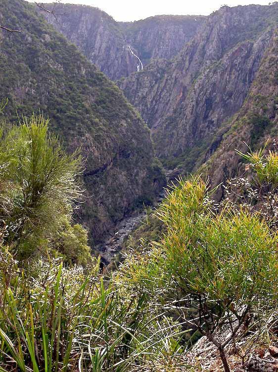
 are located in the Oxley Wild Rivers National Park, 40 km due east of Armidale, New South Wales.")
15 Wollomombi Falls Armidale Great canoeing rivers start like this, on the eastern escarpment edge of the New England tableland, east of Armidale. Wollomombi Falls (walla mom bee) are located in the Oxley Wild Rivers National Park, 40 km due east of Armidale, New South Wales. From the very top to the very bottom the height is approx 220 metres although its biggest drop where the water falls is only 100 m. The Chandler Falls are located to the right of the Wollomombi Falls when viewed from the main lookout (seen in the photograph above, as the distant falls in the upper section of the gorge that runs lower centre to upper right). After they join, these rivers (Wollomombi and Chandler) are known as the Chandler River and become a tributary of the Macleay River. The Oxley Wild Rivers National Park lies along an escarpment between the Northern Tablelands, and the east coast. This country is characterised by deep gorges and waterfalls, extensive wilderness and dry rainforest. The main rivers in the National Park are the: Apsley River, Macleay River, Chandler River, Tia River, Styx River, Gara River, Yarrowitch River, Oaky River and the Kunderang Brook. Access to this country for canoeing is limited by the steepness of the terrain. The upper river sections contain waterfalls, and the deep valleys make for limited vehicle access. In the past it was possible to access the Chandler River just downstream of the confluence of the Chandler and Styx Rivers, on the 4WD Carters Road. This road is now closed, and access is on the National Parks and Wildlife Service Halls Peak Road (booking required and access fee) which is a steep track that requires a low-range 4WD. From there, canoe downstream on the Chandler River grade 2 water, past the Macleay River confluence, the Aspley River confluence, and the last Macleay River section (grade 3) down to Georges Creek confluence, and the meeting of the Armidale Kempsey Road.


16


17
18


19 above: Wollomombi Falls below: gorge country All images in this article copyright to and courtesy of Gordon Smith lookandsee A pictorial journal of life in rural Australia

20 The Oxley River Eungella to Old Lismore Road The Oxley River from Tyalgum down to Eungella is usually run as grade 2 white water, deserving the rating because of the two metre waterfall that is shot, halfway down. Below that section, the river from the road bridge at Travis Campbell Park, Eungella, down to the culvert road crossing on the Old Lismore Road is much quieter, and the rapids are pebble races. It still deserves a grade 2 rating, but only because the river current sweeps into overhanging trees and bushes. The launch point is on the north eastern side of the concrete road bridge, six and a half kilometres along the Tyalgum Road, from Byangum, and one and a half kilometres past the school zone at Eungella. Everests Road turns off north, and there is a 150 metre long section of parkland between that road and the river. At the western end of the park, down near the river, not seen until close, is a rough road down to the water. The launch point right under the bridge is a muddy hole, and it is cleaner to put in off a very low concrete edge from old bridge works, about five metres from right under the bridge. The river consists of a series of long pools separated by rapids. At water levels over.7.0 m on the BOM gauge for Eungella, you will find the river wide enough to avoid the vegetation at a few rapids, but a walk around them is on a pleasant river gravel if you can t. Approach a couple of low bridges with due caution, depending on the river level. You can finish at Old Lismore Road, or portage over the low bridge, and paddle an extra kilometre down to Byangum, and


 and")
21 launch bridge launch 5 m upstream from this past the bridge on the private road to the Hare Krishna Community looking upstream (left) and downstream right from that bridge


22 a couple of low bridges on the way


23 Old Lismore Road bridge looking back upstream from the above bridge


24 above: the launch point underneath the Tyalgum Road bridge, Eungella. A faint track runs to the water on the right hand, upstream side of the bridge. That s Everest Road to the upper right. The park is triangle shaped from near the house to the river.. below: the exit point on Old Lismore Road.


25 above: This photograph is an explanation of the state of the river at lower water levels. At such times, the water channel will be much narrower, and it will run under and through low tree branches. Higher water levels give the paddler a wider channel, and the ability to avoid the strainers. below: road map... use your pdf reader zoom button to see clearly

26 summit trail Mt Warning NSW Mt Warning Canoeists on many of the rivers in far north NSW will see Mt Warning in the background. The view from the mountain summit at 1156 m. is far reaching. The lookout platform on the northern side gives a view of the tops of multi-story buildings in Brisbane, 106 kilometres away, and the eastern platform offers a view down to Byron Bay. A tiny white spot on the headland will confirm the view of the Byron Bay lighthouse at 44.5 kilometres distance.


27 The trail to the summit is through rainforest, and the view from the top is often obscured by cloud or rain. The walk is pleasant in damp weather, as the trail crosses several small streams, and zigzags its way up. The distance up is 4.5 km, with the last 400 metres being a scramble up a steep rocky face with a safety chain rail. Mooball Creek view NSW Expect to take from 2 to 3 hours to top out, with half an hour less time coming down. The slow times are due to the uneven rocky trail surface. A steep drop is often to one side of the narrow path. There can be large crowds on the mountain, with slow passage times up the summit chain. Rous River view NSW There are National Park signs that count off the kilometres in one kilometre increments. The starting one kilometre section is a cruel never ending series of steep steps, so don t rush the start, and the track soon evens out. There are some equally cruel thorn bushes right next to the track, so pay attention to your surroundings. There are Gympie Stinging Trees near the track in places. These can give a severe sting requiring hospitalisation, with residual pain for weeks. The track off the mountain sinks into dark shadow after 4:00 pm in the winter months, so you should have reached the top and turned around by 2:00 pm, unless you are prepared for the dark. Sandals are not appropriate footwear, and you should have 2 litres of water with you. Access to the mountain (two hours from Brisbane) is on the Murwillumbah to Uki Road, turning off 9 kilometres out of Murwillumbah. Late comers on sunny days will not find a car parking space. Tweed River view NSW Clarrie Hall Dam view NSW Mt Warning view of Clarrie Hall Dam


28 STONE FISH TRAPS Fish traps in Queensland were constructed by aboriginal, South Sea islanders (sugar cane labourers from 1860 to 1900, and Europeans. The idea is that fish swim in over stone walls at high tide, and are trapped as the tide falls. Fish traps are oval, v shaped, circular, and rectangular. These fish traps shown, below, are on Murray (Mer) Island in Torres Strait. Rectangular in shape, they measure about 160 metres long, and 140 metres out from the shore. A shallow sloping shoreline ensures less destructive waves. images from Google Earth
 from the beach, covered with native weirs, for catching fish.")
 many fish are left within these enclosed spaces, or, together with crabs and other sea")
29 An observer on the surveying voyages of HMS Fly in Torres Strait, , wrote of stone fish traps on Darnley Island, Torres Strait... Sandy flats, dry at low water, stretch out two or three hundred yards ( m) from the beach, covered with native weirs, for catching fish. These are walls of loose stone, about three feet (91cm) high, formed in curves and semicircles along the sand flats, each having a radius of one or two hundred yards (90-180m). They are completely covered at high water, but when the tide falls, (its range being about ten feet, (3m) many fish are left within these enclosed spaces, or, together with crabs and other sea creatures, caught in the interstices of the stones There are stone fish traps at many locations along the Queensland coast, including Hinchinbrook Island, and Hervey Bay. There is a group of five or so stone fish traps at Booral, a small village between River Heads and Urangan, Hervey Bay. above: Booral locality map below: Booral fish traps


30 There is a stone fish trap at Sandstone Point, Toorbul, on the shoreline that looks across Pumicestone Passage to Bribie Island. From the public carpark next to the beach, off Bestmann Road East, Sandstone Point, it is a pleasant half a kilometre walk up to the fish trap. Low tide will allow a close inspection, and footwear is essential as oyster covered rocks abound. The stone structure is in the intertidal zone, has a low stone wall in the shape of an arc and fits the general description of an Aboriginal fish trap. However, a Mr James Clark, whose family owned the land at Toorbul Point, claimed his grandfather directed South Sea Islander labourers to build the structure for the purpose of farming oysters. Other sources (including the local Abbey Museum, claim the structure is an aboriginal built fish trap. There is a large aboriginal shellfish midden nearby. However, a noted recorder of aboriginal life, Andrew Petrie, makes no mention of the fish trap although he writes of staying ten days or so in the area in the 1840 s. above: Sandstone Point locality map below: fish trap at Sandstone Point


31 above: the fish trap lies 100 metres the other side of the foreshore mangrove tree below: Sandstone Point stone fish trap


32 Red Beach Bribie Island


33 Red Beach is the strip of sand at the southern tip of Bribie Island, that runs east west from Buckley s Hole to Skirmish Point. There is a road, dirt the last half a kilometre, that runs right up to the beach. I had a look with Google to see why it is called red beach, and the answers were very ordinary, ranging from You can see Redcliffe across the bay, to I always see Red Backed Wrens in the scrub there, so I thought I would offer my two cents. During the dry years, which was the norm for about 20 years up to 2010, there was little water flowing from the freshwater swamps on Bribie. With heavy summer rain for the last couple of years, the lagoons and freshwater swamps have been filled, and there are freshwater streams running into the sea across the beach sands. The water is stained a deep red by paperbark tree tannins. On Red Beach, a small stream runs into the sea, and the red freshwater is pushed along the beach by seawater; the first couple of metres out from the shoreline is coloured red. Its a good reason as any for the name of a pretty beach. There are great views across Moreton Bay to Moreton Island, and Brisbane is visible down south across Deception Bay. If you visit here, you will probably find yourself sharing the beach with dog walkers, as this is an off leash area. On the way in you will catch a glimpse of Buckley s Hole Lagoon, a half kilometre long waterhole. The island is very low lying, and the car park for Red Beach is a dry island is the middle of a freshwater swamp. It can be a little confusing finding the road in, so I have put up a map. If you are driving down Toorbul Street, continue into Spowers Street, turn in Gregory, and follow Tully Street to the dirt road to Red Beach. It is signposted.


34 above: map with Red Beach carpark, lower right in the image. Use your pdf reader s zoom button to see clearly.


35
Upstreampaddle 25.South arm of the Brunswick River, Simpson s Creek drains the freshwater swamp lands of Tyagarah Nature Reserve, 750 hectares. Furthe
 Upstreampaddle 24 The Brunswick River is a shorter length river on the coastal plain of Northern New South Wales. The areas of interest to canoeists are: the reach from the town of Mullumbimby down to
The Albert River - from Lamington National Park down to Moreton Bay
 The Albert River - from Lamington National Park down to Moreton Bay The Lost World the Kerry Road Mt Widgee The right branch of the Albert River rises in Lamington National Park, and runs out of the park
Wattamolla to Big Marley Beach
 Wattamolla to Big Marley Beach 4 hrs 10.4 km Circuit Moderate track 4m This walk is an excellent loop which takes in both the coast and the heathy inland of Royal National Park. Nearly the whole walk has
Canoe Trip # Length of Trip: 225 kilometres Time Required to Complete Trip: 10 to 14 days Number of Portages: 21 to 25
 Canoe Trip #34 34 Brabant Lake - Wapiskau River - Steephill Lake - Reindeer River - Churchill River - Sandy Bay 225 Kilometers - 10 to 14 days - 21 to 25 portages Length of Trip: 225 kilometres Time Required
Macutagon Creek to Russell s Landing
 Day Trips Macutagon Creek to Russell s Landing Manitouwadge Public Consultation Committee Canoe Route #13 #13 MACUTAGON CREEK TO RUSSELL S LANDING This route is suitable to all levels of paddlers but due
Wentworth Falls Conservation Hut Loop
 Wentworth Falls Conservation Hut Loop 3 hrs Hard track 6.7 km Circuit 4 341m This scenic walk from Wentworth Falls Station, winds along the Nature Trail to Conservation Hut, then drops into the magnificent
Canoe Route. Dogtooth Lake-Highwind Lake-Dryberry Lake- Lake of the Woods-Blindfold Lake
 1 Canoe Route Dogtooth Lake-Highwind Lake-Dryberry Lake- Lake of the Woods-Blindfold Lake This is an interesting and challenging route starting and ending at Rushing River Provincial Park. It passes over
Campbell Drive to Snapper Point
 Campbell Drive to Snapper Point 1 hr 45 mins 4.2 km One way Experienced only 135m This walk follows the Coast Track to Frazer Beach, along the Geebung and (overgrown) Grass Tree Tracks. From the northern
Pack Rafting The Wangapeka
 Pack Rafting The Wangapeka By Nathan Fa avae PAGE 28 Issue 88 Summer 2018 Pack-rafting is a paddle sport rapidly gaining popularity in New Zealand. I first discovered pack-rafts in 2002, at the Eco Challenge
Popes Glen, Pulpit Rock, Govetts Leap and Braeside Walk
 Popes Glen, Pulpit Rock, Govetts Leap and Braeside Walk 8 hrs Hard track 13.6 km Circuit 4 1068m This large circuit walk, from Popes Glen to Pulpit Rock, Govetts leap and along the Braeside Track, passes
RIVERS KIDS HOPE AUS. THEMED MENTOR HOUR. Background: Interesting River Facts
 KIDS HOPE AUS. THEMED MENTOR HOUR RIVERS Background: Interesting River Facts The longest river in the world is the Nile River, it reaches around 6650 kilometers in length (4132 miles). More Nile River
Hunters Hill to Epping Road
 Hunters Hill to Epping Road 2 hrs 30 mins 5.5 km One way Moderate track 154m An enjoyable walk through lower sections of the Lane Cove National Park, this walk features plenty of mangroves next to the
Launch A: Experimental Lakes Road The launch site is about 4 km from highway #17. There is a sign on the highway indicating the experimental lakes
 Launch A: Experimental Lakes Road The launch site is about 4 km from highway #17. There is a sign on the highway indicating the experimental lakes road. You have to cross railway tracks on the way to the
Highland Region MAP. No. 11 St. Marys River No. 12 West River No. 13 Wallace River No. 14 Toney River No. 15 Northumberland Strait
 Highland Region MAP No. 11 St. Marys River No. 12 West River No. 13 Wallace River No. 14 Toney River No. 15 Northumberland Strait 14 Route: No. 11 St. Marys River Rating: Intermediate Advanced Length:
General Water Safety Tips
 General Wherever there is water these rules apply. Know the Aquacode Go Together, Stay Afloat and Wave, Reach to Rescue. Always swim with a friend or adult. To reach and rescue, lie down and stretch out.
SECTION 11 ADVENTUROUS ACTIVITIES PADDLING: KAYAKING
 SECTION 11 ADVENTUROUS ACTIVITIES 11.18 PADDLING: KAYAKING 11.18.1. ACTIVITY SCOPE This section relates to members participation in Kayaking as a Scouting Activity. A kayak is a small, narrow watercraft
Middle Harbour Creek Loop
 Middle Harbour Creek Loop 5 hrs 45 mins 15.1 km Circuit Experienced only 5 570m This walk explores the upper reaches of Middle Harbour Creek, starting and ending at the great parklands at Davidson Park,
Canoe Trip # Maps: 63L Amisk Lake 63M Pelican Narrows
 Canoe Trip #51 49 Southeast Arem Deschambault Lake - Pelican Narrows - Wunehikun Bay - Attitti Lake - Belcher Lake - Mukoman Lake - Ohoo Lake - Mukoman River - Sokatisewin Lake - Sandy Bay 170 Kilometers
Detailed maps, and portaging and camping information follow.
 Overview of Bain route. The launch site is at Davidson Lake, just before the Manitoba/Ontario border. You can do a loop if you leave a vehicle at Tulabi Lake (at the canoe route parking lot). The road
Downeast Lakes Water Trail and Reading Room
 Downeast Lakes Water Trail and Reading Room Last summer my 25 year old daughter Anna and I did a "canoe trip" on the Grand Lakes. We paddled, but not for bragging rights. We were there to absorb quiet,
Epping to Eastwood Station (via Lane Cove River)
") Epping to Eastwood Station (via Lane Cove River) hrs 45 mins 10.2 km One way Moderate track 189m Epping to Eastwood, via Lane Cove River, is the longer route through the bush between the stations. This
Epping to Eastwood Station (via Lane Cove River) hrs 45 mins 10.2 km One way Moderate track 189m Epping to Eastwood, via Lane Cove River, is the longer route through the bush between the stations. This
Floating the Buffalo National River. with First River Outfitter. Michelle Hulett. exp2010_w01h3buffalo2_ann_solution
 Floating the Buffalo National River with First River Outfitter Michelle Hulett The Buffalo River Beginning as just a trickle, The Buffalo National River runs down the Boston Mountains, flows north and
Epping to Pennant Hills Station (via Lane Cove River)
") Epping to Pennant Hills Station (via Lane Cove River) 3 hrs 5 mins 8.4 km One way Hard track 249m This walk, from Epping to Pennant Hills Station, is a great way to see the upper Lane Cove River Valley.
Epping to Pennant Hills Station (via Lane Cove River) 3 hrs 5 mins 8.4 km One way Hard track 249m This walk, from Epping to Pennant Hills Station, is a great way to see the upper Lane Cove River Valley.
Under and Over Cliff Walk
 Under and Over Cliff Walk 4 hrs 9.4 km Circuit Moderate track 576m This walk from Wentworth Falls Station is a fantastic way to see a large majority of the Wentworth Falls cliffline. The track winds under
Little Digger Track to Davidson Reserve and Lyrebird Circuit
 Little Digger Track to Davidson Reserve and Lyrebird Circuit 4 hrs 3 mins 11.5 km One way Hard track 4 47m Exploring both the eastern and western sides of Middle Harbour Creek, this walk follows the Little
River Dynamics - Rafting FOCUS. Read 10 point text from rear of the room. Bottom
 Dynamics - Rafting FOCUS Read 10 point text from rear of the room. Bottom 1 This section focuses on rivers; how they flow and on some basic maneuvers which you can execute on the river. Dynamics Rafting:
River. Dynamics Canoeing: This section focuses on rivers; how they flow and on some basic maneuvers which you can execute on the river.
 This section focuses on rivers; how they flow and on some basic maneuvers which you can execute on the river. Dynamics Canoeing: By Robert B. Kauffman, Ph.D. 1 Topics - Laminar and shore to center flows
HAWKESBURY-NEPEAN RIVER SYSTEM
 HAWKESBURY-NEPEAN RIVER SYSTEM Canoe & Kayak Trail Nepean River / Colo River / Hawkesbury River www.lpma.nsw.gov.au WELCOME Welcome to three canoeing and kayaking opportunities on the Hawkesbury-Nepean
Canoe/Kayak Launch Sites and Accessibility
 Canoe/Kayak Launch Sites and Accessibility Doug Alderson, Paddling Trails Coordinator Division of Recreation and Parks Office of Greenways and Trails Each potential access site on a river, lake or ocean
SELF GUIDED TOURING ROUTE
 SELF GUIDED TOURING ROUTE Things to see and places to go on the loop from Orbost to Marlo, Cape Conran, Cabbage Tree and back to Orbost (or onwards to Cann River) V6 April 2017 This guide should be read
* Making Rivers & Water Falls *
 www.krafttrains.com * Making Rivers & Water Falls * Several different methods are used to make this focal point of the layout. All the techniques are explained along with helpful hints and tips. Click
Thanks to Burt Strom, Dick Pearce, and Ed Lombardo, Sr. for their help and information.
 The upper section of the Wood River that runs approximately two miles downstream from the bridge on State Route 165 contains a number of significant pools. Although the river is constantly changing through
Fraser Island and Z Special Unit
 The sea kayaker who visits Mackenzie's Wharf in 2007 will find the satinay wood log structure in fair condition for something that was built ninety years ago, and has withstood a working life, time and
Waterfall to Heathcote
 Waterfall to Heathcote 5 hrs Hard track 10.8 km One way 4 467m This walk explores the heart of Heathcote National Park, and is easily accessed with a train station at either end. Although relatively close
In 2015 we paddled from Blue Gums Caravan Park (near Eildon) to Seymour. In 2016 we paddled from Seymour to Shepparton.
 to Seymour. In 2016 we paddled from Seymour to Shepparton.") Goulburn River Shepparton to Moama, 19-24 th November 2017 This was the third leg of the journey down the Goulburn River. In 2015 we paddled from Blue Gums Caravan Park (near Eildon) to Seymour. In 2016
Goulburn River Shepparton to Moama, 19-24 th November 2017 This was the third leg of the journey down the Goulburn River. In 2015 we paddled from Blue Gums Caravan Park (near Eildon) to Seymour. In 2016
Currie Rd to Davidson Park
 Currie Rd to Davidson Park 3 hrs 7.2 km One way Moderate track 28m Starting at Currie Rd in Forestville, this walk follows Middle Harbour to Davidson Park, under Roseville Bridge. There are two optional
Carrington Park to Leura Forest and pass loop
 Carrington Park to Leura Forest and pass loop 3 hrs Hard track 4.8 km Circuit 4 674m This walk is a fantastic way to see Leura Forest. The walk descends from Carrington Park, visiting Leura Forest and
Govetts Leap Loop. 1065m. 909m Blue Mountains National Park. 4 hrs 30 mins 8.7 km Circuit. Hard track 380m
 Govetts Leap Loop 4 hrs 30 mins 8.7 km Circuit Hard track 380m This walk, from Blackheath Train Station, is a fantastic way to see some of the iconic areas of the Blue Mountains in the Blackheath area.
Echo Point to Leura Forest via Three Sisters and Giant Stairs loop
 Echo Point to Leura Forest via Three Sisters and Giant Stairs loop 3 hrs 3.8 km Circuit Hard track 512m This walk starts from the popular Echo Point, in Katoomba, and winds down to the base of the Three
By Gloria Hildebrandt Photographed by Mike Davis except where noted
 FOLLOWING THE FISH: Owen Sound s Salmon Run By Gloria Hildebrandt Photographed by Mike Davis except where noted SALMON LIVE IN THE GREAT LAKES and the rivers of the Niagara Escarpment that drain into the
Blackheath Station to Junction Rock Loop (via Grand Canyon and Popes
 Blackheath Station to Junction Rock Loop (via Grand Canyon and Popes 8 hrs 30 mins 18.2 km Circuit Hard track 4 1254m This circuit starts in Blackheath and heads down into the Grand Canyon and Rodriguez
National Pass from Wentworth Falls to Conservation Hut
 National Pass from Wentworth Falls to Conservation Hut 3 hrs Hard track 3.6 km One way 739m Starting at Wentworth Falls picnic area, this scenic and historic walk explores many waterfalls, lookouts and
KOKODA CHALLENGE TRAINING FOR THE BEGINNER TO INTERMEDIATE
 KOKODA CHALLENGE TRAINING FOR THE BEGINNER TO INTERMEDIATE By Steven Halligan, 3 times KC finisher and Director of Halligans Fitness Personal Training. 3. Course specific fitness and training This is where
Chapter 7 Canoeing/Kayaking
 Chapter 7 83 84 Canoeing covers a wide and diverse range of disciplines including sea kayaking, white water kayaking, surf kayaking, polo, slalom, marathon, sprint, freestyle and touring. A canoe is a
Androscoggin River Trail Access Sites. Mahoosucs. 168 miles from its source at Lake Umbagog to Merrymeeting Bay
 Androscoggin River Trail Access Sites Mahoosucs 168 miles from its source at Lake Umbagog to Merrymeeting Bay Trail Under Construction More than 40 Public Access Sites Available Androscoggin River Watershed
Accident Report Entrapment Resulting in 1 Fatality Kayak 19 August 2007 Class A
 Accident Report Entrapment Resulting in 1 Fatality Kayak 19 August 2007 Class A Photograph 1 Kayak FINAL REPORT - Maritime New Zealand Investigation Report 2 1. SUMMARY 1.1 A party of four kayakers were
Berowra to Mt Kuring-gai
 Berowra to Mt Kuring-gai 4 hrs 30 mins 9.4 km One way Hard track 4 551m From the ridges above Cowan Creek, this walk takes in some great lookouts (especially around Mt Kuringgai) as well as enjoying an
Hornsby Blue Gum Walk
 Hornsby Blue Gum Walk 3 hrs Hard track 6.7 km Circuit 4 374m This delightful loop is one of the prettiest and most popular walks in the Hornsby area. Going from an environment of ferns and clear bushland
Wallarah Coastal Walk
 Wallarah Coastal Walk 3 hrs 8.3 km Return Hard track 247m This walk starts at Caves Beach and travels south along the coastline, until reaching the Pinney s Headland Lookout. There are many opportunities
De Burgs Bridge to Thornleigh station
 De Burgs Bridge to Thornleigh station 3 hrs 45 mins 9.7 km One way Hard track 4 363m This walk follows a section of the Great North Walk, starting from De Burghs bridge. The walk winds north west, through
Wentworth Falls Station Loop
 Wentworth Falls Station Loop 5 hrs 3 mins 9.5 km Circuit Hard track 4 13m The Wentworth Falls Station Loop takes in most of the upper tracks around Wentworth Falls. There are many scenic views near the
Coasts. 1. Coastal Processes. 1.1 Coastal erosion. 1.2 Sediment transport. Coastal Processes and Landforms. i. Hydraulic action
 Coasts Coastal Processes and Landforms 1. Coastal Processes 1.1 Coastal erosion i. Hydraulic action When waves strike against a rock surface, the waves trap air in the rock joints. This air is compressed
Bouddi Coastal Walk. 5 hrs. Hard track 8.1 km One way. 364m
 Bouddi Coastal Walk 5 hrs Hard track 8.1 km One way 4 364m This is one of the longer walks in the Bouddi National Park and it is rich in scenery. The walk follows the coastline with many side trips to
Wentworth Falls Loop. 893m. 665m. 6 hrs 10.2 km Circuit. Hard track 1093m. Blue Mountains National Park
 Wentworth Falls Loop 6 hrs 1.2 km Circuit Hard track 193m This is a great walk, both in size and spectacular views. The walk makes its way from Wentworth Falls train station and drops off the plateau,
Androscoggin River Trail Access Sites. Mahoosucs. 168 miles from its source at Lake Umbagog to Merrymeeting Bay
 Androscoggin River Trail Access Sites Mahoosucs 168 miles from its source at Lake Umbagog to Merrymeeting Bay Trail Under Construction More than 40 Public Access Sites Available Androscoggin River Watershed
Written by Luke Talbot-Male
 www.surfandsun.com.au Written by Luke Talbot-Male You can scroll through pages or click headings to navigate 1 Introduction - The Surfing Journey 2 The Equipment 3 The Warm Up 4 How waves are made 5 The
The Basin Track and Mackerel Track
 The Basin Track and Mackerel Track 3 hrs 5.9 km Circuit Hard track 226m This walk is a great way to see some popular areas in Ku-ring-gai Chase National Park. The walk from West Head Rd travels to The
PLANNING A TRIP TO THE SEASHORE CHECK LIST
 PLANNING A TRIP TO THE SEASHORE CHECK LIST Action: 1. Access / Facilities 2. Risk Assessment 3. First Aid / Emergency 4. Tide Tables / Changing Tides / Weather forecast 5. Volunteers 6. Plan the Day of
Wentworth Falls Station Loop (Undercliff Walk)
") Wentworth Falls Station Loop (Undercliff Walk) 4 hrs 3 mins Hard track 8.9 km Circuit 658m 4 This walk passes some stunning waterfalls and views into the Jamison Valley, following the cliff edges around
Wentworth Falls Station Loop (Undercliff Walk) 4 hrs 3 mins Hard track 8.9 km Circuit 658m 4 This walk passes some stunning waterfalls and views into the Jamison Valley, following the cliff edges around
Creek Trash Assessment (CTA) Methodology (Demonstration: Mill Run Creek, Cheltenham, Pa.)
 Methodology (Demonstration: Mill Run Creek, Cheltenham, Pa.)") Creek Trash Assessment (CTA) Methodology (Demonstration: Mill Run Creek, Cheltenham, Pa.) Mill Run Creek emerges from a storm sewer in Philadelphia to an open creek in Cheltenham. The Creek downstream
Creek Trash Assessment (CTA) Methodology (Demonstration: Mill Run Creek, Cheltenham, Pa.) Mill Run Creek emerges from a storm sewer in Philadelphia to an open creek in Cheltenham. The Creek downstream
Fraser Island nd 30 th September 2017
 Fraser Island 2017 The Great Sandy Strait 22 nd 30 th September 2017 An eight day expedition along the southern side of Fraser Island. Alternate trip due to NNW wind forecasts negating the original Hervey
Specialising in Adventure Trips with a. Personal touch.
 Specialising in Adventure Trips with a Personal touch. 2016 At X Adventure Activities we specialise in offering outdoor experiences throughout the UK with a Personal touch. At X Adventure Activities we
Glenbrook and Euroka Circuit
 Glenbrook and Euroka Circuit 2 Days 16.6 km Circuit Experienced only 790m This two day circuit, returning to Glenbrook Station, is a scenic walk which passes many of the tourist attractions within the
Callicoma Loop. 174m. 98m. 2 hrs. Hard track 5.1 km Circuit. 153m
 Callicoma Loop 2 hrs Hard track 5.1 km Circuit 153m This great circuit walk passes through some really nice forest around the fringe of Cherrybrook. Highlights of the walk include some beautiful rock overhangs
Axe Vale Canoe Club (AVCC) Risk Register GENERIC RISK ASSESSMENT
 Risk Register GENERIC RISK ASSESSMENT") GENERIC RISK ASSESSMENT Slips, Trips and Falls Drowning Leader to inspect area of operation. under 18 year olds will wear a safety helmet when on the water. Shoes to be worn at all times outside changing
GENERIC RISK ASSESSMENT Slips, Trips and Falls Drowning Leader to inspect area of operation. under 18 year olds will wear a safety helmet when on the water. Shoes to be worn at all times outside changing
Beautiful Walks from the Blue Ball Inn
 Walk No. 7 COAST AND VALLEY WALK Countisbury, Glenthorne, County Gate, Brendon, Rockford and Wilsham 10 MILES APPROX. Walking time 5 hours approx. (not including breaks)> OS Sheet 64/74 Lynton and Lynmouth.
Walk NOC 03 Location: Llyn y Fan (the lake) and Fan Brycheinog (the mountain) off Trecastle Road
 and Fan Brycheinog (the mountain) off Trecastle Road") 8 Walk NOC 03 Location: Llyn y Fan (the lake) and Fan Brycheinog (the mountain) off Trecastle Road Directions: Distance (miles): Time (hours): Length of Walk: Turn right out of the castle, take first left
8 Walk NOC 03 Location: Llyn y Fan (the lake) and Fan Brycheinog (the mountain) off Trecastle Road Directions: Distance (miles): Time (hours): Length of Walk: Turn right out of the castle, take first left
2018 Kathmandu Coast to Coast - Race Safety Briefing (Compulsory Section to attend)
") 2018 Kathmandu Coast to Coast - Race Safety Briefing (Compulsory Section to attend) These notes are current at time of email additional safety messages will be given at the pre-race safety briefings at
2018 Kathmandu Coast to Coast - Race Safety Briefing (Compulsory Section to attend) These notes are current at time of email additional safety messages will be given at the pre-race safety briefings at
Kayak Trip Yeppoon to Stanage Bay (Central Qld coast)
") Kayak Trip Yeppoon to Stanage Bay (Central Qld coast) August 2018. Robin Aurisch. This trip was inspired by a report on the Upstream Paddle site where 5 paddlers did a similar trip back in 2009. To make
Kayak Trip Yeppoon to Stanage Bay (Central Qld coast) August 2018. Robin Aurisch. This trip was inspired by a report on the Upstream Paddle site where 5 paddlers did a similar trip back in 2009. To make
Birches Valley Forest Centre is located in the heart of Cannock Chase Forest between Stafford, Cannock and Rugeley in Staffordshire, England.
 Birches Valley Forest Centre Introduction The Forestry Commission is the biggest provider of outdoor recreation in the UK and aims to offer quality woodland access to the widest range of visitors as possible.
Epping to Gordon Station
 Epping to Gordon Station 4 hrs 15 mins 11.7 km One way Hard track 4 365m This walk, from Epping Station to Gordon Station, passes below the homes which sit on the hills high above the Lane Cove River.
Float Trips CANOEING. Bass River Resort
 Float Trips Bass River Resort 800-392-3700 www.basscanoeresort.com basscanoeresort@misn.com CANOEING Canoeing is delightful on the crystal clear Courtois, Huzzah, and Meramec Rivers. We offer 6, 7, and
Marteg to Newbridge, October 2012 onwards.
 Marteg to Newbridge, October 2012 onwards. Map symbols: Reach Length: 12.4 miles Terms and Conditions: Canoeing can take place only when the water height is above 0.8m on the EAW gauge at Dhol Farm AND
9. APPENDICES Disciplines of Mountain Biking
 9. APPENDICES 9.1. Disciplines of Mountain Biking Cross-country Cross-country mountain biking is the oldest discipline within the sport and is analogous to cross-country running or skiing. It involves
ROUTE 2. Bateau Channel. Topographic Map 31 C/8 Navigation Charts 1438/39 Reference Maps
 Topographic Map 31 C/8 Navigation Charts 1438/39 Reference Maps ROUTE 2 Bateau Channel The shoreline marshes of the Bateaux Channel team with life. Wetlands provide breeding habitat for amphibians, fish
THE FIRST MOUNTAIN BIKE TRAIL CENTRE IN THE GCC & MIDDLE EAST
 THE FIRST MOUNTAIN BIKE TRAIL CENTRE IN THE GCC & MIDDLE EAST INTRODUCTION WELCOME TO HATTA TRAIL CENTRE WEBSITE Hatta Trail Centre is a first MTB Centre in the Middle East, and is a home to multiple cross
Federal Pass Walking Track
 Federal Pass Walking Track 5 hrs Hard track 8 km One way 4 989m This classic trail follows along the base of the cliffs from Leura to the Golden Stairs, passing many of the more popular sights of the Katoomba
Environmental Definitions and Deployment Guidance for Instructors, Coaches and Leaders
 Environmental s and Deployment Guidance for Instructors, Coaches and Leaders This document provides guidance and environmental definitions that can be applied when choosing paddlesport activity. British
Shoreline Studies Program, Department of Physical Sciences, VIMS
 Living Shoreline Training Class 2017 1 Demonstration sites discussed in this talk. 2 A shoreline management plan for the entire creek made conceptual shoreline management recommendations along every stretch
Katoomba Falls Circuit
 Katoomba Falls Circuit hr 5 mins.5 km Circuit Hard track 59m For those looking for a walk involving more than simple boardwalk, this trail winding through the temperate rain forest could be just the thing.
3 STAR TRIPS & ACTIVITIES
 Lower Tryweryn Weekend trip This is a classic grade 2 section of river from the National Whitewater Centre in Frongoc down to Bala. There is one grade 3 section at the very start and a grade 4 drop at
Surfers Against Sewage Are Calling For A Review of the UK s Bathing Water Sample Sites.
 Surfers Against Sewage Are Calling For A Review of the UK s Bathing Water Sample Sites. Welsh Report Surfers Against Sewage (SAS) believe the weekly bathing water samples required by the EU Bathing Water
PADDLING THE LOWER STILLAGUAMISH RIVER by Paddle Heaven
 PADDLING THE LOWER STILLAGUAMISH RIVER by Paddle Heaven PUBLISHED BY: Paddle Heaven on Smashwords Paddling the Lower Stillaguamish River Copyright 2010 by Paddle Heaven All rights reserved. Without limiting
International Learn To Swim Programme Water Safety Questions
 International Learn To Swim Programme Water Safety s s for First Step Series s Poolside Safety & Poolside Rules 1. Where is the shallow end of the The answer is specific to the centre. swimming 2. When
West River 180. There are 3 main types of home built kayaks that are within the abilities of anybody:
 West River 180 During the months of July and August 2001 I lost my last remnants of sanity, covered my back deck with plastic, and spent every spare moment I had building my own kayak. Since I have yet
Estuarine Shoreline Stabilization
 Estuarine Shoreline Stabilization Property Owner s Guide to Determining the Most Appropriate Stabilization Method Estuarine shorelines are dynamic features that experience continued erosion. Land is lost
Mackerel Beach and Resolute Loop
 Mackerel Beach and Resolute Loop 3 hrs 5.4 km Circuit Hard track 384m This walk is another great walk in Ku-ring-gai Chase National Park, accessed by ferry. From the Mackerel Beach wharf, this walk uses
Beach Profiles: Monitoring Sea Level Rise. Student Activity Sheet. Name Date Class
 Beach Profiles: Monitoring Sea Level Rise Student Activity Sheet Name Date Class A shoreline is the area where the water and land meet. This is where we find beach: areas where sediments (sand or other
Approximate distance: 10 miles For this walk we ve included OS grid references should you wish to use them. Start. End
 Approximate distance: 10 miles For this walk we ve included OS grid references should you wish to use them. 2 3 Start End 1 N W E S Reproduced by permission of Ordnance Survey on behalf of HMSO. Crown
TITLE: COASTAL EROSION AND LANDFORMS.
 TITLE: COASTAL EROSION AND LANDFORMS. AIM: What are the factors that influence the formation of coastal features along Fishing Pond beach Trinidad? LOCATION OF FIELD STUDY: The study was carried out in
Balmoral Beach to The Spit
 Balmoral Beach to The Spit 2 hrs 30 mins.3 km One way Hard track 85m This walks follows the coast from Balmoral to the Spit and across Spit Bridge. There are some alternate tracks to consider at high-tides,
Marginal Marine Environments
 Marginal Marine Environments Delta: discrete shoreline protuberances formed where rivers enter oceans, semi-enclosed seas, lakes or lagoons and supply sediment more rapidly than it can be redistributed
In the case of capsize, staff to ensure all participants involved are accounted for and safe. ANY NON-PADDLERS MUST STAY AWAY Low High
 RISK ASSESSMENT FOR: Canoeing and Kayaking Reviewed Feb 2018 Written by: Kevin Beattie (Paddlesport Tech Advisor) HAZARD Severity Likelihood LIST OF CONTROL MEASURES OVERALL RESIDUAL RISK RATING (/Med/High)
3 Maps and Charts In order to navigate we need to use some form of map. The two choices are nautical charts, or land maps.
 13 3 Maps and Charts In order to navigate we need to use some form of map. The two choices are nautical charts, or land maps. Charts Nautical Charts only show the land detail that is visible from the sea.
DESCRIPTION OF THE CHELAN RIVER
 DESCRIPTION OF THE CHELAN RIVER The following information contains excerpts from the Whitewater Boating Feasibility Study conducted on the Chelan River in July, 2000. The Chelan River begins below the
Morgans Creek to Padstow
 Morgans Creek to Padstow 2 hrs 45 mins 8 km One way Moderate track 3 144m This pleasant walk starts from the Morgans Creek park, at Henry Lawsons Drive, and follows the Georges River past the Boomerang
Mogollon Rim and White Mountains Angler Report
 Mogollon Rim and White Mountains Angler Report Becker Lake, Monday, Nov. 6 Blain O.: Becker Lake fished well last week though the water was cold (50- degrees F at the surface). Fish were scattered everywhere
Patonga to Woy Woy. 5 hrs 45 mins 15.5 km One way. Hard track. 497m
 Patonga to Woy Woy 5 hrs 45 mins 15.5 km One way Hard track 4 497m This walk explores a variety of environments from the shore line and coastal cliffs near Patonga, to the dry, rocky and open ridge line.
READING AND LISTENING. A beach. By John Russell
 READING AND LISTENING http://learnenglish.britishcouncil.org/en/magazine/beach A beach By John Russell life jacket water-sport cliff capsize (v.) paradise float (v.) sanctuary refuge anchor (v.) rock pool
WALKABILITY CHECKLIST How walkable is your community?
 WALKABILITY CHECKLIST How walkable is your community? Everyone benefits from walking and other forms of active transportation. These benefits include: improved fitness, cleaner air, reduced risks of certain