ROCKAWAY BOARDWALK RECONSTRUCTION Phase 4 (B86th B60th) Access Update October 28, 2014
|
|
|
- Tiffany Stevenson
- 5 years ago
- Views:
Transcription
 Access Update October 28,")
1 ROCKAWAY BOARDWALK RECONSTRUCTION Phase 4 (B86th B60th) Access Update October 28,
 Target Start: Spring 2014 Summer 2014 Fall 2014 Spring 2015 Late 2014* Fall 2015* Fall 2016* Target End: Memorial Day 2015 July 4 th 2015 Memorial Day 2016 Memorial Day 2016 Memorial Day 2016*")
2 Construction Schedule Phase: Phase 1 (B86-B97) Phase 2 (B98-B108): Phase 3 (B108-B126): Phase 4a (B73-B86): Phase 4b (B60-B73) Phase 5a (B39-B60): Phase 5b (B19-B39) : *Piping Plover Moratorium (Apr Sept) Target Start: Spring 2014 Summer 2014 Fall 2014 Spring 2015 Late 2014* Fall 2015* Fall 2016* Target End: Memorial Day 2015 July 4 th 2015 Memorial Day 2016 Memorial Day 2016 Memorial Day 2016* Memorial Day 2016* Memorial Day 2017* 2

3 Boardwalk Finish Planks 3

4 Boardwalk Materials 4

5 Bike Lane Markings 5

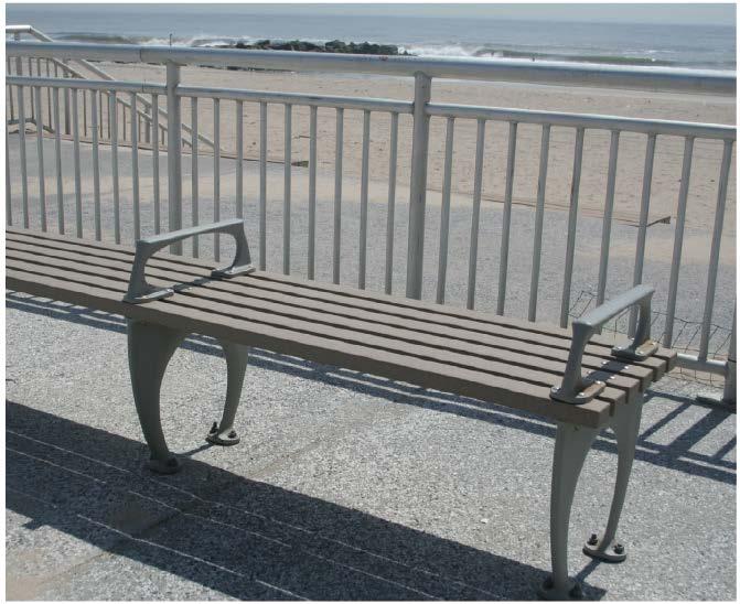
6 World s Fair Bench 6

7 Custom Seating 7

8 Landside Planter 8

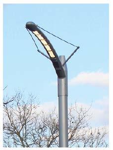
9 Lighting 9


10 Fountains and Showers 10

11 Signage 11
12 Dune Planting 12
13 Baffle Wall 13

14 Dune Planting 14

15 Typical Planting Plan 15

16 Planting Pallet 16

17 Typical Landside Access 17


18 Typical Landside Access 18

19 Typical Beachside Access 19
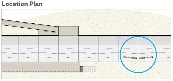
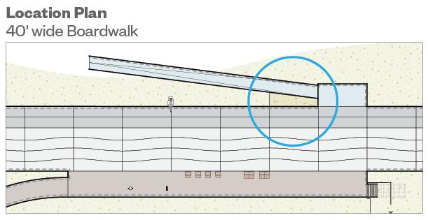
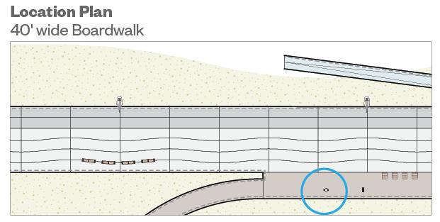
20 SANDY DUNE WAY B 68TH ST BEACH FRONT ROAD B 69TH ST B 67TH ST EXISTING ISLAND BEACHFRONT PRESERVEBEACHFRONT PRESERVE Vehicular ramp FEET FEET Proposed stairs to be changed to small ramp L5 - Combined access. Stairs and accessible path B-BP1 - Stairs 8 wide Proposed stairs to be Proposed stairs to be L1 - Stairs 10 wide B-BP2 - Combined L-BP1 access. - Stairs 10 wide B1 - Stairs 8 wide changed to ramp & changed stairs to small ramp L2 - Stairs 20 wide Stairs and L-BP2 accessible - ADA dune Ramp crossing B2 - Combined access. L3 - ADA Ramp L-BP3 - Combined access. Stairs and accessible L4 - Accessible dune crossing path with step seating V1 - Landside vehicular ramp Stairs and accessible path V1 - Landside vehicular L5 - Combined ramp access. Stairs and accessible V2- Beachside path vehicular B-BP1 ramp - Stairs 8 wide Beach side vehicular Proposed stairs V2- to be Beachside vehicular B1 - Stairs ramp8 wide ramp added changed to ramp & stairs B2 - Combined access. Stairs and accessible dune crossing Beach side vehicular ramp added L1 - Stairs 10 wide L2 - Stairs 20 wide L3 - ADA Ramp L4 - Accessible path with step seating V1 - Landside vehicular ramp V2- Beachside vehicular ramp L-BP1 - Stairs 10 wide L-BP2 - ADA Ramp L-BP3 - Combined access. Stairs and accessible path B-BP2 - Combined access. Stairs and accessible dune crossing V1 - Landside vehicular ramp V2- Beachside vehicular ramp P4b - B 73rd St Island to B 65th St - Proposed R O C K AWAY B OA R DWA LK R EC O N STRUCTION NYC PARKS NYC EDC CH2MHILL WXY RBA PENTAGRAM
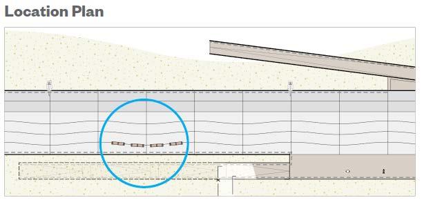
21 BEACH WAY BEACHFRONT PRESERVE B 62ND ST B 61ST ST B 60TH ST FEET Proposed stairs to be changed to small ramp Proposed stairs to be changed to ramp & stairs Beach side vehicular ramp added L1 - Stairs 10 wide L2 - Stairs 20 wide L3 - ADA Ramp L4 - Accessible path with step seating L5 - Combined access. Stairs and accessible path B1 - Stairs 8 wide B2 - Combined access. Stairs and accessible dune crossing V1 - Landside vehicular ramp V2- Beachside vehicular ramp L-BP1 - Stairs 10 wide L-BP2 - ADA Ramp L-BP3 - Combined access. Stairs and accessible path B-BP1 - Stairs 8 wide B-BP2 - Combined access. Stairs and accessible dune crossing V1 - Landside vehicular ramp V2- Beachside vehicular ramp P4b - B65th St to B60th St - Proposed R O C K AWAY B OA R DWA LK R EC O N STRUCTION NYC PARKS NYC EDC CH2MHILL WXY RBA PENTAGRAM
22 Questions?


23 SHOR E FRO BASKETBALL COURT HANDBALL COURT HANDBALL COURT EET D STR EET H 73R H STR BEAC NT PA RKWA Y PAVED AREA PLAYGROUND BEAC BEAC Y A W K R A P T N O R F H 74T H STR H 77T BEACH 81S SHORE EXISTING ACCESSIBLE RAMP EXISTING STAIRS EET T STREET REET H ST H 84T BEAC R.O.W. R.O.W. R.O.W. EXISTING PLANTER PLAYGROUND SHOR E FRO EXISTING ISLAND NT PA RKWA Y HANDBALL COURT BASKETBALL COURT HANDBALL COURT CREST OF U.S.A.C.E. DUNE TOE OF U.S.A.C.E. DUNE EXISTING PLAYGROUND EXISTING ACCESSIBLE RAMP & STAIRS BEACH FRONT ROAD EXISTING MODULAR BUILDINGS LEGEND CREST OF U.S.A.C.E. DUNE TOE OF U.S.A.C.E. DUNE EXISTING CONDITIONS RIGHT OF WAY TAX LOT LINE PRE-SANDY ACCESS STAIR SITE ANALYSIS A TO MTA STATION EXISTING ACCESSIBLE RAMP PARK NON-ACCESSIBLE RAMP CONNECTION TO THROUGH STREET EXISTING ISLAND PROPOSED ACCESS EXISTING ISLAND ACCESSIBLE RAMP & STAIRS VEHICULAR RAMP PROPERTY OWNERSHIP IN QUESTION 0 Pre-Sandy Access & Proposed Access Phase 4a FEET SCALE: 1 =50-0

24 BEACH 73RD STREET MERIDIAN BLVD SANDY DUNE WAY BEACH 69TH STREET BEACH 68TH STREET A TO BEACH 67TH ST STATION BEACH 67TH STREET OCEAN AVENUE S. BEACH 62ND STREET BEACH 61ST STREET BEACH 60TH STREET EXISTING ACCESSIBLE RAMP EXISTING ISLAND BEACH FRONT ROAD BEACH 59TH STREET PLAYGROUND BEACH 59TH STREET EXISTING RAMP & STAIRS CREST OF U.S.A.C.E. DUNE TOE OF U.S.A.C.E. DUNE PHASE 5 CREST OF U.S.A.C.E. DUNE TOE OF U.S.A.C.E. DUNE LEGEND EXISTING CONDITIONS CREST OF U.S.A.C.E. DUNE TOE OF U.S.A.C.E. DUNE RIGHT OF WAY TAX LOT LINE PRE-SANDY ACCESS SITE ANALYSIS APPROXIMATE PRE-SANDY SHORELINE PARK EXISTING ISLAND PROPOSED ACCESS STAIR NON-ACCESSIBLE RAMP A TO MTA STATION CONNECTION TO THROUGH STREET APPROXIMATE PRE-SANDY SHORELINE ACCESS BY OTHER (PER PDC PRESENTATIN PROPERTY OWNERSHIP IN QUESTION VEHICULAR RAMP ATLANTIC OCEAN EXISTING JETTY FEET SCALE: 1 =50-0 Pre-Sandy Access & Proposed Access Phase 4b
ATLANTIC COAST OF LONG ISLAND, JONES INLET TO EAST ROCKAWAY INLET, LONG BEACH ISLAND, NY. Contract #2 Construction Scope. April 18th-19th 2018
 ATLANTIC COAST OF LONG ISLAND, JONES INLET TO EAST ROCKAWAY INLET, LONG BEACH ISLAND, NY Contract #2 Construction Scope April 18th-19th 2018 New York District PLAN COMPONENTS Length of Beachfill 35,000
A. INTRODUCTION For the Environmental Assessment, the term dune is used to describe the 14 to 16 foot elevation sand
 Chapter 1: Project Description A. INTRODUCTION The City of New York (the City) is proposing to enter into a grant agreement with the United States Department of Housing and Urban Development (HUD) to disburse
Regional Beach Access
 Beach and Bay Access Finding your perfect beach is easy when you have so many choices. South Walton has over 50 beach and bay access points along its 26 miles of shoreline. Types of access vary, so be
FOCUS AREA 1 - Alberta Avenue Pocket Park 3 (121 Ave and 92 St)
") FOCUS AREA 1 - Alberta Avenue Pocket Park 3 (121 Ave and 92 St) New benches Plant evergreen trees Widen existing sidewalk from 1.5m to 1.8m Marked crosswalk 1.8m wide sidewalk Add pedestrian oriented lights
FOCUS AREA 1 - Alberta Avenue Pocket Park 3 (121 Ave and 92 St) New benches Plant evergreen trees Widen existing sidewalk from 1.5m to 1.8m Marked crosswalk 1.8m wide sidewalk Add pedestrian oriented lights
Atlantic Coast of Long Island, Jones Inlet to East Rockaway Inlet, Long Beach Island, NY Construction Update
 Atlantic Coast of Long Island, Jones Inlet to East Rockaway Inlet, Long Beach Island, NY Construction Update June 2016 US Army Corps of Engineers Project Purpose Three specific damage mechanisms of coastal
Q1 Which of the following best describes your relationship to Atlantic Beach?
 Q1 Which of the following best describes your relationship to Atlantic Beach? Answered: 1,183 Skipped: 0 Full-Time Resident of... Seasonal Resident of... Visitor Business Owner in Atlantic... Full-Time
Appendix F: Public Access Plan
 Atlantic Coast of Long Island Jones Inlet to East Rockaway Inlet Long Beach Island, New York Coastal Storm Risk Management Project Hurricane Sandy Limited Reevaluation Report Appendix F: Public Access
Astoria Boulevard ADA and Station Renewal Track Improvements. February 19, 2019
 Astoria Boulevard ADA and Station Renewal Track Improvements February 19, 2019 Major Scope of Work Replace Street and Platform Stairs Work Description Install Two Street-to-Mezzanine Elevators Install
STAGE #3 TRANSITION 1 at Camp Keystone
 STAGE #3 SWIM STAGE #3 TRANSITION 1 at Camp Keystone Mount bike AFTER bump T1 Changing Tent STAGE #3 Camp Keystone to Marineland 68 MILE BIKE STAGE #3 68 MILE BIKE Mile 0-10 SAG 0.0 Turn RIGHT out of T1.
BIKETOBERFEST October 13-16, 2016 Updated :15PM
 America s Best Value Inn 1305 South Ridgewood Avenue Daytona Beach 386-252-1142 Atlantic Ocean Palm Inn 3247 South Atlantic Avenue Daytona Beach Shores 386-761-8450 Bahama House 2001 South Atlantic Avenue
Financial Project ID No(s).: and ETDM No(s).: and 14181
.: and ETDM No(s).: and 14181") Palm Beach Metropolitan Planning Organization (MPO) Presentation I-95 at Boynton Beach Boulevard Interchange and I-95 at Gateway Boulevard Interchange Project Development and Environment Study Palm Beach
Palm Beach Metropolitan Planning Organization (MPO) Presentation I-95 at Boynton Beach Boulevard Interchange and I-95 at Gateway Boulevard Interchange Project Development and Environment Study Palm Beach
BIKETOBERFEST October 13-16, 2016 Updated :15AM
 ***This is a list of properties that we have been able to contact who currently have availabilities for Biketoberfest (). This list changes daily. America s Best Value Inn 1305 South Ridgewood Avenue Daytona
Derby Street. Project Updates. Salem, Massachusetts
 Derby Street Project Updates Salem, Massachusetts September 13, 2017 Project Limits Derby Street Project Objectives 1. Improve complete streets elements on Derby Street 2. Improve sidewalks on finger streets
Southeast Volusia Coastal Projects Update
 Southeast Volusia Coastal Projects Update Public Works Department Coastal Division August 15, 2016 2016 Dune Walkover Re-Decking Program Completed Dune Walkovers South End 8 th Ave. New Smyrna Beach* 12
Visit for more information, including the full 2017 program route.
 Philly Free Streets is a family-friendly, people-powered initiative of the City of Philadelphia that temporarily closes a street route to vehicular traffic, inviting people to bike, walk, and play. Philly
CITY OF LANCASTER PROPOSED NEW PROJECTS
 CITY OF LANCASTER 2013-2014 PROPOSED NEW PROJECTS Project Code 11 Facilities and Fixtures Project Title 1 11BS018 Main. Yard Storage Bldg, Phase 2 2 11GS007 Parks Improvements 3 11GS008 Dog Park AHP 4
BIKETOBERFEST October 13-16, 2016 Updated :25PM
 ***This is a list of properties that we have been able to contact who currently have availabilities for Biketoberfest (). This list changes daily. America s Best Value Inn 1305 South Ridgewood Avenue Daytona
Beach Renourishment in Jacksonville
 Beach Renourishment in Jacksonville Kevin Bodge, PhD, P.E. - Olsen Associates, Inc. 1978 Oct 2004 2000 2016 2011 Oct 2016 Coastal Duval County, FL Nassau Sound Blount Island Ft. George Inlet St. Johns
RIVERSIDE, Newton MA BH NORMANDY RIVERSIDE LLC. Riverside Station. A green, transit-oriented community
 Riverside Station A green, transit-oriented community October 6, 2011 TONIGHT S AGENDA: 1. Project Update (5 min.) 2. Master Plan Update (10 min.) 3.Traffic Plan Update (10 min.) Questions & Answers MASTER
APPENDIX A: Complete Streets Checklist DRAFT NOVEMBER 2016
 APPENDIX A: Complete Streets Checklist DRAFT NOVEMBER 2016 Complete Streets Checklist MetroPlan Orlando s Complete Streets Checklist is an internal planning tool for staff to further implementation of
The Sand Beaches of New Hampshire and Maine
 The Sand Beaches of New Hampshire and Maine Beach Preservation and Erosion Control Photographs provided by Joe Kelly and Steve Adams Cover photo: Reid State Park, ME Introduction The sand beaches of New
Building Great Neighbourhoods BELLEVUE AND VIRGINIA PARK
 Building Great Neighbourhoods BELLEVUE AND VIRGINIA PARK This is Meeting 2 Unfortunately, some residents in Bellevue and Virginia Park received the wrong information for this public open house (Meeting
PROJECT KEY TYPICAL SECTION 1 =60
 6 WASHINGTON BLVD - BETWEEN NE 1ST ST AND NE 3RD ST Washington Boulevard is a low volume, low speed one-way road, signed for no street between NE 1st Street and NE 2nd Street, and closed to traffic between
Walton County Beach Access Selection Chart
 Walton County Beach Selection Chart Beach Lupine #1 No No 242 Walton Magnolia Ln., Inlet, FL 32413 Phillip's Inlet Beach #1a (3 Spaces) N/A 202 S Walton Lakeshore Dr., Inlet, FL 32413 Inlet RBA (East)
TRANSPORTATION ALTERNATIVES PROGRAM: SELECTED PROJECTS AND FUNDING ALLOCATIONS
 ITEM #9: TRANSPORTATION ALTERNATIVES PROGRAM: SELECTED PROJECTS AND FUNDING ALLOCATIONS The Transportation Alternatives Program (TAP) created by MAP-21 requires that 50% of the program funds received by
May 10, 2013 Meredith Cruz, (561) Palm Beach County Traffic Report May 10 through May 17, 2013
 Palm Beach County Traffic Report May 10 through May 17, 2013") May 10, 2013 Meredith Cruz, (561) 641-6440 mcruz@corradino.com Palm Beach County Traffic Report May 10 through May 17, 2013 Palm Beach County Palm Beach County traffic will be affected this week by ongoing
May 10, 2013 Meredith Cruz, (561) 641-6440 mcruz@corradino.com Palm Beach County Traffic Report May 10 through May 17, 2013 Palm Beach County Palm Beach County traffic will be affected this week by ongoing
Public Access Quarterly Report
 7/7/2017 Public Access Quarterly Report Clean Ocean Access update of 50 CRMC rights-of-way on Aquidneck Island. Contributing Authors: Eva Touhey, Program Manager, Clean Ocean Access Megan Carvalho, Communications
WELCOME! OPEN HOUSE SHAW ROAD IMPROVEMENT PROJECT JUNE 30, 2015
 WELCOME! OPEN HOUSE SHAW ROAD IMPROVEMENT PROJECT JUNE 30, 2015 Traffic Improvements Project Goals Widen roadway to construction two-way left turn lanes-greatly decreases congestion Ease access to & from
US 20 Feasibility Study. Village Board Meeting. Shales Parkway to IL Route 390 IL Route 390 Extension (North Ave to US 20)
") US 20 Feasibility Study Shales Parkway to IL Route 390 IL Route 390 Extension (North Ave to US 20) Village Board Meeting Bartlett Village Hall February 16, 2016 1 Background 1991 IDOT Study Recommendations
US 20 Feasibility Study Shales Parkway to IL Route 390 IL Route 390 Extension (North Ave to US 20) Village Board Meeting Bartlett Village Hall February 16, 2016 1 Background 1991 IDOT Study Recommendations
See Figure 38, Existing Nonmotorized Connections.
 Nonmotorized Connections Existing Nonmotorized Connections Pedestrian, vehicle and bike traffic access and movements are confined primarily to Penny Drive on campus. Due to the steep slope along the length
WHEREAS delivery trucks also pass through the Narrows, into the northern parking lot, to loading docks in the back of the building.
 CEDAR-ISLES-DEAN NEIGHBORHOOD ASSOCIATION ( CIDNA ) RESOLUTION OPPOSING A DRUG STORE DRIVE THRU, AND COMMENDING DORAN COMPANIES FOR PROPOSING MITIGATING AMENITIES INCLUDING NEW LANDSCAPING AND A DEDICATED
Sloat Blvd. Pedestrian Safety Improvement Project
 Sloat Blvd. Pedestrian Safety Improvement Project Department of Public Works Project team and background Budget Schedule Scope of work Sloat Blvd - Everglade Drive Sloat Blvd - Forest View Drive Sloat
Proposed Mural. Ninth St. Proposed Sitting Area. Proposed Bump-out. Bike Lane and Buffer Zone. Proposed Trees and Sitting Area.
 Proposed Mural Proposed Sitting Area Ninth St Proposed Bump-out Bike Lane and Buffer Zone Proposed Trees and Sitting Area Tenth St Bike Sign to Lake 47 Proposed Trees and Sitting Area Eighth St Bike Lane
FY 2016 TRANSPORTATION ALTERNATIVES PROGRAM PROJECT SELECTION
 AGENDA ITEM #8: FY 2016 TRANSPORTATION ALTERNATIVES PROGRAM PROJECT SELECTION The Transportation Alternatives Program (TAP) created by MAP-21 requires that 50% of the program funds received by the state
GLYNN COUNTY MANAGER S OFFICE 1725 Reynolds Street, Third Floor, Brunswick, GA Phone: (912) Fax: (912)
 Fax: (912)") GLYNN COUNTY MANAGER S OFFICE 1725 Reynolds Street, Third Floor, Brunswick, GA 31520 Phone: (912) 554-7401 Fax: (912) 554-7596 www.glynncounty.org MEMO TO: FROM: The Honorable Commissioners Alan Ours,
GLYNN COUNTY MANAGER S OFFICE 1725 Reynolds Street, Third Floor, Brunswick, GA 31520 Phone: (912) 554-7401 Fax: (912) 554-7596 www.glynncounty.org MEMO TO: FROM: The Honorable Commissioners Alan Ours,
Emerson Circle Entrance
 Emerson Circle Entrance It is not clear that there is a park in this location without a sign. Access from Emerson Circle: The present sloped granite curb does not provide access immediately at the park
TRANSPORTATION IMPROVEMENT STRATEGY
 TRANSPORTATION IMPROVEMENT STRATEGY A Vision for Staten Island North Shore November 2016 1 EXISTING CONDITIONS Transit Conditions MTA Bus Staten Island Railroad Peak Directional Traffic Volume (per hour)**:
STREETSCAPE CONCEPTS
 STREETSCAPE S CARGO WAY CARGO WAY CYCLE TRACK Streetscape Concepts JENNINGS ST Illustrative Plan EVANS AVE PG&E BAY TRAIL HERON S HEAD PARK The recommended improvements build off the planned improvements
Non-Motorized Transportation 7-1
 Non-Motorized Transportation 7-1 Transportation facilities no longer mean just accommodating a vehicle powered by a combustion engine. Pedestrian and non-motorized facilities are important modes of travel
14 TH STREET TRANSPORTATION & STREETSCAPE DESIGN STUDY PLAN B PLAN B TRANSPORTATION & STREETSCAPE RECOMMENDATIONS
 14 TH STREET TRANSPORTATION & STREETSCAPE DESIGN STUDY PLAN B PLAN B TRANSPORTATION & STREETSCAPE RECOMMENDATIONS 141 Symbols Recommendations - Southern End of 14th Street Study Area Streetscape Each icon
PUBLIC REALM MASTER PLAN
 WESTSHORE BUSINESS DISTRICT PUBLIC REALM MASTER PLAN MASTER PLAN COMMITTEE MEETING MARCH 20, 2013 WESTSHORE BUSINESS DISTRCT PUBLIC REALM MASTER PLAN MACRO-SCALE CONCEPT: A PUBLIC REALM FRAMEWORK DEFINED
Waterfront Trail; Lynde Creek to Pickering
 Waterfront Trail; Lynde Creek to Pickering Ride starts at Lynde Creek C.A., Whitby 0.0 0.0 Victoria St. (caution - busy road!) 0.6 0.6 Halls Rd. 1.8 2.4 gravel path 0.2 2.6 gravel path (towards Lk. Ontario)
OTTAWA AVENUE NEIGHBORHOOD
 OTTAWA AVENUE NEIGHBORHOOD 4.17.2018 RECAP September 19, 2016 Meeting Identify concerns * needs * wants of neighborhood residents Safety Improvements Ottawa Avenue, Ayersville Avenue, Cleveland Avenue,
ATLANTIC COUNTY 2006 to 2008
 ATLANTIC COUNTY 2006 to 2008 The Atlantic County oceanfront shoreline consists of three barrier islands where the northern one, Little Beach Island and a third of the second, Brigantine Island, are undeveloped
Functional, Preliminary Design and Detailed Design
 Functional, Preliminary Design and Detailed Design Main Street (Echo Drive to the Rideau River), Lees Avenue (Main Street to Chestnut Street), and Rideau River Drive (Main Street to 130m south of Main
Figure 106. Locations of the 28 NJBPN profile stations in Ocean County, NJ.
 130 Figure 106. Locations of the 28 NJBPN profile stations in Ocean County, NJ. 131 2016-2017 Beach Fills in Ocean County: The federal/state/local storm damage reduction project (beachfill) between Manasquan
F L E T C H E R A V E N U E
 Jan. 29, 2014 Introduction F L E T C H E R A V E N U E FDOT Local Agency Program (LAP) Project FPN: 428214-1-58-01 CIP 63090 Hillsborough County, Traffic Engineering, PWD Stake holders and partners are
Ormond Beach s Andy Romano Beachfront Park. Imagine. City Commission Meeting June 1 st, Presented by
 Ormond Beach s Andy Romano Beachfront Park Imagine City Commission Meeting June 1 st, 2011 Presented by Who are we? Daytona Regional CHAMBER OF COMMERCE 2010 Small Business Of the Year Presented To Zev
Figure 38. Locations of the 28 NJBPN profile stations in Ocean County, NJ.
 55 Figure 38. Locations of the 28 NJBPN profile stations in Ocean County, NJ. 56 Individual Site Descriptions: Northern Ocean County recovered its beaches approaching pre-hurricane Sandy elevation or width,
Plainfield Gateway. Plainfield Context
 Plainfield Gateway The western arm of The Campus, much like the Thomas Street Placita eastern arm, must connect residents and workers from the western side of the neighborhood to The Campus and the activity
February 11, 2016 TPO Board Presentation
 February 11, 2016 TPO Board Presentation SR A1A (Highway A1A) US 192 to SR 404 (Pineda Causeway), Brevard County, Florida Financial Project Number: 428753-1-32-01 Project Limits US 192 to SR 404 (428753-1)
Dear Mr. Tweed: Sincerely, Min Zhou, P.E. Vice President
 December 17, 2012 Mr. Steve Tweed City of Long Beach, Department of Public Works Traffic & Transportation Bureau, 10 th Floor City Hall 333 West Ocean Boulevard Long Beach, CA 90802 Subject: Broadway and
Marina Bay Trail Community Meeting #1
 Marina Bay Trail Community Meeting #1 AGENDA 1. Introductions: Meghan Tiernan, DPW Cristina Olea, DPW Jerry Robbins, SFMTA 2. Meeting Purpose:. 4. 5. 6. To introduce the project to the community and gather
New Jersey Saltwater Fishing Beach Access compliments of New Jersey Beach Buggy Association
 New Jersey Saltwater Fishing Beach Access compliments of New Jersey Beach Buggy Association GATEWAY SANDY HOOK: Dates of operation: The season runs from Memorial Day to Labor Day, and the times are from
DELAWARE S VULNERABLE COASTAL AREAS. DELAWARE INLAND BAYS and DELAWARE BAY RECONNAISSANCE STUDY
 DELAWARE S VULNERABLE COASTAL AREAS and the DELAWARE INLAND BAYS and DELAWARE BAY RECONNAISSANCE STUDY Kimberly K. McKenna, PG Delaware Dept. of Natural Resources & Environmental Control Division of Watershed
Falls Lake Trail (A part of the NC Mountains-to-Sea Trail) East to West
 East to West") Falls Lake Trail (A part of the NC Mountains-to-Sea Trail) East to West Section 1 (Falls of the Neuse Rd to Raven Ridge Rd) 0.0 mi Parking area of the Tailrace Fishing Area, just below the dam, off Falls
Falls Lake Trail (A part of the NC Mountains-to-Sea Trail) East to West Section 1 (Falls of the Neuse Rd to Raven Ridge Rd) 0.0 mi Parking area of the Tailrace Fishing Area, just below the dam, off Falls
SAFE SCHOOL WALK ROUTES (SSWR) TASKFORCE ADVISORY COMMITTEE 7 TH MEETING MEETING AGENDA
 TASKFORCE ADVISORY COMMITTEE 7 TH MEETING MEETING AGENDA") SAFE SCHOOL WALK ROUTES (SSWR) TASKFORCE ADVISORY COMMITTEE 7 TH MEETING MEETING AGENDA DATE: MONDAY, 5/22/2017 TIME: 6:00 8:00 P.M. LOCATION: CITY HALL, CONFERENCE ROOM #107 Call to Order/Approval of
SAFE SCHOOL WALK ROUTES (SSWR) TASKFORCE ADVISORY COMMITTEE 7 TH MEETING MEETING AGENDA DATE: MONDAY, 5/22/2017 TIME: 6:00 8:00 P.M. LOCATION: CITY HALL, CONFERENCE ROOM #107 Call to Order/Approval of
11TH & VERMONT SPRC MEETING 4 1/25/ th & North Vermont. Ballston, VA R2L:ARCHITECTS 1 PROJECT TEAM
 PROJECT TEAM DEVELOPER/OWNER NVR Inc. 11700 Plaza America Drive Suite 500 Reston, VA. 20190 T: 703-956-4775 Contact: John Halak Jay Johnson ATTORNEY Mcguire Woods, LLP 1750 Tysons Boulevard 18th Floor
Shoalwater Bay Shorline Erosion Dredging
 Shoalwater Bay Shorline Erosion Dredging ROSS ISLAND SAND & GRAVEL CO. Saving the Tokeland Penninsula Willapa Bay & Tokeland Penninsula Southwestern Washington Coast Shoalwater Bay Historic View Settlements
Complete Streets Funding Program Project Prioritization Plan
 Funding Program Project Prioritization Plan Location and Type Needs South Street Crosswalk Installation Stripe a new formalized crosswalk across South Street at the Anne T. Dunphy School pedestrian path
Pine Point Study Committee. Report and Recommendations to Scarborough Town Council. December 10, 2009
 The Delphi Group, Inc Results through Alignment: Linking Direction, Capability & Commitment Pine Point Study Committee Report and Recommendations to Scarborough Town Council December 10, 2009 Committee
TO: FROM: SUBJECT: RECOMMENDATION REPORT SUMMARY BOARD AUTHORITY
 February 8, 2018 TO: Park Board Chair and Commissioners FROM: General Manager Vancouver Board of Parks and Recreation SUBJECT: Douglas Park Playground Replacement - Construction Contract RECOMMENDATION
Building Great Neighbourhoods QUEEN ALEXANDRA
 Building Great Neighbourhoods QUEEN ALEXANDRA We are here today to Explain how the City is investing in improving your neighbourhood and how your neighbourhood will be improved to meet current City standards.
MEMORANDUM. Existing Operations. City of Clearwater. Michael Herrman. Date: January 26, Seminole Boat Launch Overview. M&N Job No.
 1509 W. Swann Avenue, Suite 225 Tampa, FL 33606 (813) 258-8818 Fax (813) 258-8525 www.moffattnichol.com MEMORANDUM To: From: City of Clearwater Michael Herrman Date: Subject: Seminole Boat Launch Overview
Brooklyn Boulevard (County Road 152) Reconstruction Project Phase I. OPEN HOUSE June 20, 2017
 Reconstruction Project Phase I. OPEN HOUSE June 20, 2017") Brooklyn Boulevard (County Road 152) Reconstruction Project Phase I OPEN HOUSE June 20, 2017 Brooklyn Boulevard (County Road 152) Phase I Project Partners Project Lead Other Project Partners include Brooklyn
Brooklyn Boulevard (County Road 152) Reconstruction Project Phase I OPEN HOUSE June 20, 2017 Brooklyn Boulevard (County Road 152) Phase I Project Partners Project Lead Other Project Partners include Brooklyn
AUTHORIZE BID ADVERTISEMENT
 STAFF REPORT MEETING DATE: May 17, 2016 TO: City Council FROM: Petr Skala, Assistant Engineer PRESENTER: Russell Thompson, Public Works Director 922 Machin Avenue Novato, CA 94945 415/ 899-8900 FAX 415/
MILEGROUND - AIRPORT ROAD. Fall 2018/ Spring Fall 2020 TBD. US 119 Monongalia County HOW WILL TRAFFIC CONTROL BE HANDLED: KNOW BEFORE YOU GO
 MILEGROUD - AIRPORT ROAD US 119 Monongalia County The Mileground - Airport Road project on US 119 involves upgrading the three-lane facility to a five-lane facility to help eliminate congestion and improve
Community Redevelopment Agency Regular Meeting July 12, 2016
 Community Redevelopment Agency Regular Meeting July 12, 2016 The Community Redevelopment Agency (CRA) of the City of Titusville, Florida met in regular session in the Council Chamber of City Hall, 555
City Avenue Projects
 City Avenue Projects City Avenue Special Services District Conceived in the early 1990 s Lita Cohen, Jim Ettelson, Joe Manko, and Michael Nutter Saint Joseph s provided key start-up support. True Public/Private
STREETSCAPE CONCEPT PLAN
 03 STREETSCAPE CONCEPT PLAN Zone 1 This zone includes the gateway into both the downtown and the Village at Harlem. The gateway features are shown closer to the Harlem intersection to make them more prominent.
U.S. HIGHWAY 50 IMPROVEMENT PROJECT
 U.S. HIGHWAY 50 IMPROVEMENT PROJECT in the City of South Lake Tahoe Project Purpose and Need Planned Improvements Project Cost and Delivery Schedule Proposed Construction Staging Project Partners: HIGHWAY
Portage Bay Park Design Commission Review 4: 90% Design Development January 5, 2017
 to be updated to reflect base bid condition Portage Bay Park Design Commission Review 4: 90% Design Development January 5, 2017 Previous Site Plan POTENTIAL PARK CONNECTION & MID-BLOCK CROSSING BOAT STREET
Assateague Island National Seashore North End Restoration Project Timeline
 Assateague Island National Seashore North End Restoration Project Timeline Date Event Some information provided in the Project Introduction document. Detailed events are available in a timeline compiled
THE ALAMEDA CONCEPT DESIGN COMMUNITY MEETING 3. A Plan for The Beautiful Way JANUARY 28, 2010
 CONCEPT DESIGN COMMUNITY MEETING 3 JANUARY 28, 2010 AGENDA INTRODUCTION COMMUNITY INPUT ROADWAY STUDIES STREETSCAPE DESIGN STATIONS DISCUSSION SUMMARY AND DISCUSSION NEXT STEPS CLOSE INTRODUCTION SCHEDULE
San Francisco Bay Area Water Trail Site Description for. Cuttings Wharf
 1 San Francisco Bay Area Water Trail Site Description for Cuttings Wharf Location, Ownership, and Management: Cuttings Wharf is a public boat launch on the Napa River, located at 1230 Cuttings Wharf Road
DISTRICT BICYCLE PROGRAM
 DISTRICT BICYCLE PROGRAM TxDOT Fort Worth District Public Hearing Bicycle Use on the State Highway System Public Hearing Agenda 1 2 3 4 5 6 Introduction Susan Howard TxDOT Public Involvement Specialist
Meadow Woods Elementary School
 Drag and drop pic and stretch/crop to the limits of the blue rectangle (delete this text box) Meadow Woods Elementary School Drag and drop pic and stretch/crop to the limits of the blue rectangle (delete
ADA Training Accessible Pedestrian Signal (APS) 2018 MnDOT
 2018 MnDOT") ADA Training Accessible Pedestrian Signal (APS) 2018 MnDOT APS and ADA APS is not currently an ADA Standard and is provided at the discretion of the Title II entity APS is recognized in the MnMUTCD, but
ADA Training Accessible Pedestrian Signal (APS) 2018 MnDOT APS and ADA APS is not currently an ADA Standard and is provided at the discretion of the Title II entity APS is recognized in the MnMUTCD, but
Active Transportation Rail to River Corridor. Community Meeting - Segment A
 Active Transportation Rail to River Corridor Community Meeting - Segment A June 29, 2017 Tonight s Agenda > Open House (30 min) > Welcome / Project Overview > Presentation of 30% Design Refinements > Next
I-290 Phase I Study Village of Forest Park November 9, of 25
 I-290 Phase I Study Village of Forest Park November 9, 2015 1 of 25 I-290 Study Area Reconstruction Section (9 miles) Re-striping Section (4 miles) 13 miles West of Mannheim Road to Racine Avenue Connects
Modeling Beach Erosion
 Ocean Lecture & Educator s Night May 16, 2012 Modeling Beach Erosion Below is an overview of the activity Modeling Beach Erosion (New Jersey Sea Grant Consortium, Education Program) to incorporate information
HELM RANCH ROUND 2 - COMMUNITY WORKSHOP AND OPEN HOUSE SUMMARY
 HELM RANCH ROUND 2 - COMMUNITY WORKSHOP AND OPEN HOUSE SUMMARY Tarpey Elementary School, Clovis, CA October 15, 2014 6:30pm-8:30pm OVERVIEW On Wednesday, October 15, 2014, staff from the City of Clovis
George Washington Bridge Restoring the George Construction Program Supplemental Information on Bicycle and Pedestrian Access
 George Washington Bridge Restoring the George Construction Program Supplemental Information on Bicycle and Pedestrian Access The replacement of the George Washington Bridge suspender ropes is part of the
Parking. Parking 11/27/2012. On street parking. Off-street parking is space provided for vehicular parking outside the dedicated street right-of-way.
 Parking On street parking Off-street parking is space provided for vehicular parking outside the dedicated street right-of-way. At-grade parking lot Parking garages SITE Parking 90 degree (20 x 9 stalls)
I-290 Phase I Study Area OAK PARK AVE AUSTIN BLVD. Reconstruction Area (9 miles) Oak Park RIDGELAND AVE CENTRAL AVE HARLEM AVE. Cicero.
 Oak Park RIDGELAND AVE CENTRAL AVE HARLEM AVE. Cicero.") RIDGELAND AVE OAK PARK AVE AUSTIN BLVD UP-RR BRC-RR ASHLAND AVE Study Area Map I-290 Phase I Study Area 294 UP RR Metra UP-W Illinois Prairie Path 38 Berkeley WOLF RD Hillside MANNHEIM RD Bellwood 290
RIDGELAND AVE OAK PARK AVE AUSTIN BLVD UP-RR BRC-RR ASHLAND AVE Study Area Map I-290 Phase I Study Area 294 UP RR Metra UP-W Illinois Prairie Path 38 Berkeley WOLF RD Hillside MANNHEIM RD Bellwood 290
Tonight is for you. Learn everything you can. Share all your ideas.
 Strathcona Neighbourhood Renewal Draft Concept Design Tonight is for you. Learn everything you can. Share all your ideas. What is Neighbourhood Renewal? Creating a design with you for your neighbourhood.
TO: Board Members Vancouver Park Board FROM: General Manager Parks and Recreation SUBJECT: Seaside Greenway Improvements
 Date: October 1, 2013 TO: Board Members Vancouver Park Board FROM: General Manager Parks and Recreation SUBJECT: Seaside Greenway Improvements RECOMMENDATION A. THAT the Board approve the new bike paths
Community Advisory Committee (CAC) Workshop #6
 Workshop #6") Community Advisory Committee (CAC) Workshop #6 MEETING SUMMARY HELD Tuesday, September 9, 2014 6:30 8:30 PM Nokomis Community Center 2401 E. Minnehaha Pkwy Minneapolis, MN 55417 Meeting Purpose: Discuss
Community Advisory Committee (CAC) Workshop #6 MEETING SUMMARY HELD Tuesday, September 9, 2014 6:30 8:30 PM Nokomis Community Center 2401 E. Minnehaha Pkwy Minneapolis, MN 55417 Meeting Purpose: Discuss
APRIL 1, 2015 APWA CONFERENCE. TIM HANSEN, PE Chief Operating Officer AHBL, Inc. Project Designer
 DIANE WIATR Active Transportation Coordinator/Senior Planner City of Tacoma APRIL 1, 2015 APWA CONFERENCE TIM HANSEN, PE Chief Operating Officer AHBL, Inc. Project Designer MATT PAVOLKA Project Manager
Point Defiance Park. Master Plan
 Point Defiance Park Master Plan Public Participation 1/29, 2/26, 3/26 & 4/23 Owen Beach Ferry Zoo Fort Nisqually Mildred Street Pearl Street Triangle Hare & Hare Master Plan - 1911 2008 Concept Plan Comments
This page intentionally left blank.
 This page intentionally left blank. Community Plan Skiatook Community Overview Skiatook Skiatook is a growing city located approximately 14 miles north of downtown Tulsa with its main street, W.C. Rogers
STAKEHOLDER MEETING STANFORD RANCH ROAD/GALLERIA BOULEVARD/SR 65 NORTHBOUND RAMPS PROJECT APPROVAL & ENVIRONMENTAL DOCUMENT (PA&ED) PHASE
 PHASE") STAKEHOLDER MEETING STANFORD RANCH ROAD/GALLERIA BOULEVARD/ SR 65 NORTHBOUND RAMPS PROJECT APPROVAL & ENVIRONMENTAL DOCUMENT (PA&ED) PHASE January 12, 2016 Welcome and Introductions Meeting Goals I 80/SR
STAKEHOLDER MEETING STANFORD RANCH ROAD/GALLERIA BOULEVARD/ SR 65 NORTHBOUND RAMPS PROJECT APPROVAL & ENVIRONMENTAL DOCUMENT (PA&ED) PHASE January 12, 2016 Welcome and Introductions Meeting Goals I 80/SR
City Avenue Projects
 City Avenue Projects City Avenue Special Services District Conceived in the early 1990 s Lita Cohen, Jim Ettelson, Joe Manko, and Michael Nutter Saint Joseph s provided key start-up support. True Public/Private
REGIONAL BICYCLE AND PEDESTRIAN DESIGN GUIDELINES
 REGIONAL BICYCLE AND PEDESTRIAN DESIGN GUIDELINES November 16, 2011 Deb Humphreys North Central Texas Council of Governments Bicycle and Pedestrian Advisory Committee Snapshot of the Guide 1. Introduction
BALBOA AREA: TRANSPORTATION PROJECTS & PLANNING
 BALBOA AREA: TRANSPORTATION PROJECTS & PLANNING TRANSPORTATION FOR ALL AGES, ABILITIES & MEANS CHANGING PATTERNS: TRENDING TO WALKING, BIKING, TRANSIT San Francisco s Change in Number of Commuters by Mode
INGHAM COUNTY ROAD DEPARTMENT AUSTIN E. CAVANAUGH ADMINISTRATION BUILDING 301 Bush Street, P.O. Box 38, Mason, MI
 INGHAM COUNTY ROAD DEPARTMENT AUSTIN E. CAVANAUGH ADMINISTRATION BUILDING 301 Bush Street, P.O. Box 38, Mason, MI 48854-0038 March 27, 2018 William M. Conklin, P.E. Managing Director FOR IMMEDIATE RELEASE:
Existing Transportation System
 < Open for Additional Text Transportation System Existing Transportation System This section describes vehicular transportation associated with Children s. transportation are described in a separate section
Figure79. Location map for the 10 NJBPN profile sites in Atlantic County, NJ 155
 154 Figure79. Location map for the 10 NJBPN profile sites in Atlantic County, NJ 155 ATLANTIC COUNTY SPRING 2009 to FALL 2010 The Atlantic County coastline consists of three barrier islands. Between Little
NJDOT Complete Streets Checklist
 Background The New Jersey Department of Transportation s Complete Streets Policy promotes a comprehensive, integrated, connected multi-modal network by providing connections to bicycling and walking trip
Site 1180_042 Kekaulike Mall. Bikeshare Hawaii. Location: ewa side of Kekaulike Mall makai of Hotel Street. Power Source: solar
 Station located on the ewa side of Kekaulike Mall makai of Hotel Street 24 18 wide clear space remains for pedestrians and maintenance/emergency vehicles 40 Location: ewa side of Kekaulike Mall makai of