Downtown Talent Master Plan
|
|
|
- Randall Bennett
- 5 years ago
- Views:
Transcription
1 Master Plan Prepared for: Talent Urban Renewal Agency Talent, Oregon Prepared by: Robert Bernstein, P.E. Consulting Transportation Engineer/Planner
2 Master Plan CONTENTS Introduction. 1 Existing Conditions. 5 Impacts of Proposed Development Recommendations Appendix A: Peak Traffic Volumes Appendix B: Traffic Operations Analysis Methodology Appendix C: Traffic Count Reports Appendix D: Level of Service Worksheets FIGURES Figure 1. Downtown Talent Master Plan Figure 2. Study Area Figure 3. Intersection Traffic Count Locations Figure 4. Traffic Control Inventory Figure 5. Crosswalk and On-Street Parking Inventory... 8 Figure 6. Existing Daily Traffic Volumes Figure 7. Time-of Day Traffic Volumes Distribution Figure 8. Downtown Talent Bus Service TABLES Table 1. Intersection Level of Service for Existing Conditions Table 2. Master Plan Traffic Generation and Parking Demand Table 3. Summary of Intersection Level of Service Analysis Results
3 Master Plan INTRODUCTION In 2006, the City of Talent adopted in concept the West Valley View Vision Master Plan, which was prepared under the auspices of the Talent Urban Renewal Agency. One of the longstanding goals of the City of Talent is to establish a vital downtown that grows with the community, and the West Valley View area plays an essential role in expanding and enhancing the downtown core for businesses and citizens. The adopted Master Plan concept, as shown in Figure 1, envisions and promotes mixed use development, includes a new street network design for the master plan area, and provides community-oriented amenities. The Master Plan s goals are to provide a safe and efficient transportation system, open up properties for business development or redevelopment, address awkward lot configurations and street geometries, support historic preservation, provide community amenities, and support the downtown core area for businesses and for citizen use. The purpose of the transportation element of the Plan is to design a new street network for the area that will incorporate alleyways, pedestrian accesses, and shared parking options. This report documents the traffic and parking analyses prepared for the West Valley View Vision Master Plan. Purpose The basic purpose of the is to determine the traffic and parking needs of the initial stage and full buildout of the West Valley View Master Plan, as adopted in concept by the City Council. Within this general framework there are five specific purposes: (1) To ensure that the street improvements recommended by the West Valley View Vision Master Plan are integrated into the downtown Talent street system in a manner that maintains and enhances smooth convenient access and circulation throughout the downtown, including the Downtown Study Area (see Figure 2) and taking into consideration John Street and Ganges Drive; (2) To provide the traffic operations and parking needs analyses required by the City of Talent, to be included as an appendix to the Master Plan previously included as an amendment to the Comprehensive Plan and Transportation Systems Plan (TSP;)


4 Page 2 Figure 1: Downtown Talent Master Plan Figure 2: Study Area
5 Page 3 (3) To determine the street improvement needs to a level of detail and certainty that will allow engineering design to begin; and (4) To establish guidelines and recommendations for implementation of the Master Plan transportation elements, including phasing. (5) To address specific Issues of Concern (see Issues to be Addressed subsection, following). Approach The approach employed to prepare the for the West Valley View Vision Master Plan started with the Master Plan recommendations. As an initial step, the recommendations were reviewed in terms of their integration with the broader downtown Talent street and transportation system, and refinements were considered as appropriate. The product of the is this report, which defines a complete and prioritized set of downtown Talent street and parking improvements, and documents the supporting technical analyses. The results were presented to URA officials, city staff and officials, and the public as appropriate. Issues to be Addressed The specific Issues of Concern identified by the public and City and URA staff for additional study and inclusion in this report are listed below. 1. Lane configurations at all intersections (including feasibility or necessity for left turn lanes) 2. A second alternative to the Wagner Street extension (south of pottery buildings) 3. Phasing of Master Plan improvements (including interim plans for the new roundabout intersection and the remaining portions of West Valley View) 4. ODOT regulations regarding proximity of roundabouts to state highways 5. Options for improvement at intersection of Market Street (formerly I Street) and Wagner 6. Assessment of traffic signal warrant requirements at study area intersections 7. Perceived narrowing of Wagner extension between pottery buildings 8. Accommodation of all transportation modes (pedestrians, bicycles, RVTD bus service) 9. Compare parking analysis to existing parking ordinance and identify discrepancies or potential modifications to ordinance 10. Discuss methods for keeping through-traffic off of Gangnes 11. Deliveries/loading in alleys, marked zones, etc.
 Study Area The study area for the includes the streets and intersections potentially affected by Master Plan area traffic and street network changes.")
6 Page Lining up of alleys and minor streets 13. Shared parking opportunities adjacent to downtown study area (examples: Talent Friends Church parking lot, medical complex parking lot, etc.) Study Area The study area for the includes the streets and intersections potentially affected by Master Plan area traffic and street network changes. The study intersections are listed and shown in Figure 3. Figure 3: Intersection Traffic Count Locations (1) Hwy 99/W Valley View Rd (2) Talent Ave/W Valley View Rd (3) Talent Ave/Wagner St (4) Market St/Wagner St (5) John St/Wagner St (6) Front St/Wagner St (7) Talent Ave/Main St (8) Market St/Main St (9) John St/Main St (10) Front St/Main St (11) Talent Ave/LaPree St (12) Talent Ave/Sunny St New St
7 Page 5 EXISTING CONDITIONS The existing conditions section contains a description of the existing transportation system and covers four topics: existing access and circulation, existing traffic volumes, existing traffic operations, and existing bus service. Existing Access and Circulation Roadway Configuration and Traffic Control The street system providing access to/from the site is shown in Figure 2 and Figure 3. Vehicular access into and out of downtown Talent is provided by West Valley View Rd to/from the east, Talent Ave to/from the north and south, and Wagner St and Main St to/from the west. West Valley View provides connections to Hwy 99 at a signalized intersection on the east edge of the study area, and further to the east, to I-5 at Exit 21. Talent Ave provides connections to Colver Rd and Hwy 99 (via Colver) on the north, and to Rapp Rd and Hwy 99 (via Rapp) on the south. Wagner St and Main St provide connections to city neighborhoods and schools west of downtown. The function and classification of study area streets (as specified by the City of Talent Transportation System Plan) are described below. West Valley View Rd is a Minor Collector that extends east from Talent Ave to and beyond a signalized intersection at Hwy 99. West Valley View Rd provides the only Hwy 99 connection into downtown Talent, and is the only full connection to Hwy 99 between Colver Rd and Rapp Rd. Talent Ave north of Wagner St is a Minor Arterial that extends north to Colver Rd immediately west of the signalized Colver/Hwy 99 intersection, where it provides a connection to the county and regional road system to the north. Sourth of Wagner St Talent Ave is a Major Collector that parallels Hwy 99 and provides connections to the neighborhoods and communities south of downtown Talent. Main St and Wagner St are Major Collectors that extend west from Talent Ave into the residential neighborhoods west of downtown. Market St (formerly I St) is a Local Street that connects LaPree St, Main St, and Wagner St immediately west of Talent Ave, and serves primarily internal downtown access and circulation needs.
8 Page 6 LaPree St is a Local Street that extends west from Talent Ave into the residential neighborhoods north of downtown. LaPree also provides access for the northwest section of the downtown area. John St is a Local Street that connects Main St and Wagner St west of Market St, and serves primarily internal downtown access and circulation needs. Front St is a Minor Collector that extends north from Wagner St on the west side of the railroad tracks, and serves primarily the residential neighborhoods west of the tracks. New St is a Local Street that extends east from Talent Ave to a right-in/right-out only intersection at Hwy 99. It provides limited local access for the northeast section of the downtown area. Sunny St is a Local Street that extends west from Talent Ave into the residential neighborhoods north of downtown. Intersection traffic controls are shown in Figure 4, and marked crosswalks and on-street parking spaces are are shown in Figure 5. Existing Traffic Volumes The traffic volume information needed for the Traffic Analysis was derived from a set of 24-hour directional hose counts (daily volume counts) and peak period intersection traffic counts that were made in the study area in May, Daily Volumes Daily volume counts were made at five locations in and around downtown Talent: Talent Ave north of Gangnes, Talent Ave south of Colver, West Valley View Road west of Hwy 99, Main St west of Front St, and Wagner St west of Front St. The daily volume counts total are compiled in Figure 6, and the time-of-day distribution of the daily traffic volumes are compiled in Figure 7. As shown in Figure 6, daily traffic volumes in downtown Talent are modest. With daily volumes of 6,500 vehicles per day (vpd) on West Valley View, 3,000-4,000 on Talent Ave, 4,000 on Main St, and 2,000 on Wagner St, downtown street system capacity is more than adequate. As shown in Figure 7, despite the fact that there is some peaking in the morning and evening commute periods and around school dismissal time, traffic volumes on the downtown Talent street network are fairly constant all day long. This indicates that use of the street network is primarily local, and that there is little external through traffic on Talent Ave or elsewhere.

9 Figure 4: Traffic Control Inventory Downtown Talent Page 7

10 Figure 5: Cross-Walk and On-Street Parking Inventory Downtown Talent Page 8

11 Figure 6: Existing (May, 2007) Daily Traffic Volumes Downtown Talent Page 9


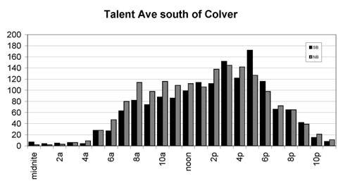


12 Page 10 Figure 7: Existing (May, 2007) Time-of-Day Traffic Distribution
13 Page 11 Peak Period Intersection Volumes Weekday p.m. peak period intersection traffic counts were collected at 12 key intersections in the study area in May, Counts were made at Hwy 99/W Valley View Rd, Talent Ave/W Valley View Rd, Talent Ave/Wagner St, Market St/Wagner St, John St/Wagner St, Front St/Wagner St, Talent Ave/Main St, Market St/Main St, John St/Main St, Front St/Main St, Talent Ave/LaPree St, and Talent Ave/Sunny St New St. The peak hour counts are compiled in Appendix A, Figure A-1, and the count reports are attached in Appendix C. Existing Traffic Operations The traffic operational analysis focused on the 12 key study area intersections The operational analysis was performed for weekday p.m. peak hour conditions, when traffic volumes are greatest and operating conditions are the most difficult. Methodology The traffic operations analyses were based on the Level of Service (LOS) determined for each study intersection. The methodology is described in detail in Appendix B. Results Traffic operational analysis results are compiled in Table 1, which includes intersection level of service (LOS) and average delay for weekday p.m. peak hour conditions. As shown in Table 1, all study intersections have adequate capacity for current volumes and operate at LOS B or better conditions during weekday and weekend peak periods. Level of service analysis worksheets are compiled in Appendix D. Existing Bus Service In Talent and Jackson County, transit service is provided by the Rogue Valley Transit District (RVTD). RVTD operates one fixed-route bus line that serves Talent: RVTD s Route 10 serves Medford, Phoenix, Talent, and Ashland (see Figure 8), providing service on 30-minute headways on weekdays. As shown in Figure 8, Route 10 operates on Hwy 99 north of downtown Talent and on Talent Ave south of downtown. Southbound service gets off Hwy 99 at Colver Rd and enters downtown Talent on Talent Ave, while northbound service follows West Valley View Rd from Talent Ave to Hwy 99.
14 Page 12 Table 1: Intersection Level of Service (LOS) for Existing Conditions Existing (2007) Intersection LOS v/c a) W Valley View / Hwy 99 signalized intersection B 0.56 W Valley View / Talent Ave NB Talent, WB Valley View [stop sign] non-standard control LOS n/a Colver Rd / Talent Ave NB Talent [stop sign] B 0.23 Sunny St New St / Talent Ave EB Sunny [stop sign] WB New [stop sign] A A LaPree St / Talent Ave EB LaPree [stop sign] B 0.02 Main St / Talent Ave SB Talent, EB Main [stop sign] non-standard ctl; LOS n/a Wagner St / Talent Ave EB Wagner [stop sign] B 0.23 Main St / Market St NB Market [stop sign] SB Market [stop sign] B B Main St / John St NB John [stop sign] B 0.06 Main St / Front St NB Front [stop sign] A 0.01 Wagner St / Market St SB Market [stop sign] B 0.08 Wagner St / Front St all-way stop intersection A 0.17 a) v/c = volume: capacity ratio

15 Figure 8: Downtown Talent Bus Service Downtown Talent Page 13
16 Page 14 Future Baseline Traffic Volumes For the purposes of this traffic analysis, completion and full occupancy of the development envisioned by the Master Plan was assumed to occur with in 10 years. Accordingly, 2017 was used as the analysis year for this study. In order to analyze the impacts of the proposed development in 2017, an estimate of 2017 baseline, or background traffic volumes was needed. ( Baseline traffic is the volume of traffic expected to be on the street system without the Master Plan development.) For the purposes of this analysis, it was estimated that over the course of the 10-year analysis horizon (2007 to 2017), existing 2007 traffic volumes would increase by a total of 16% (1.6% per year) 1. Using this growth rate, 2017 baseline volumes were projected from the 2007 volume counts, and were reassigned to the Master Plan street network; estimated 2017 baseline peak hour volumes are compiled in Appendix A, Figures A-2 and A year traffic growth rate developed for and used in Transportation Impact Study for ClearviewPlanned Development (submitted to City of Talent on behalf of Archerd & Dresner LLC by Alex Georgevitch Consulting, February, 2005)
17 Page 15 IMPACTS OF MASTER PLAN DEVELOPMENT Master Plan Development Scenario The development/redevelopment and the street network envisioned by the West Valley View Master Plan were used as the basis for this traffic and parking analysis. A layout plan of the development and street network defined by the Master Plan is shown in Figure 1, and the Master Plan development and street network are described in the following subsections. Development/Redevelopment The West Valley View Master Plan envisions development and redevelopment equivalent to approximately 80% of what is permitted by the underlying zoning. The traffic and parking analysis was based on full buildout of that 80% during the planning period, which comprises: Multi-family residential: 219 units General office space: 67,200 sq ft General retail space: 44,800 sq ft Off-street parking: 780 spaces Street Network The Master Plan proposes a reconfiguration of the downtown street network, comprising extensions of Main St and Wagner St from Talent Ave to West Valley View Rd at a point midway between Talent Ave and Hwy 99, and the closure of West Valley View Rd west of that point. The reconfigured four-leg Talent Ave/Main St and Talent Ave/Wagner St intersections were analyzed with all-way stop control. Because the Wagner St Extension may not be built for some time, the Master Plan traffic analyses were prepared for two street networks: one that includes the Main St Extension only (Phase I) and one that includes the Wagner St Extension as well (Phase II). Master Plan Traffic Analysis Traffic Generation/Distribution The volume of traffic generated by buildout of the development envisioned by the Master Plan was estimated using the Trip Generation Manual, 7th Edition, published by the Institute of Transportation Engineers. Trip generation estimates are compiled in Table 2.
 1 2 Land Use Type Sector 1 (Northwest) ITE Land Use Code size daily trips, weekday weekday p.m.")
18 Page 16 Table 2: Master Plan Traffic Generation a) and Parking Demand b) 1 2 Land Use Type Sector 1 (Northwest) ITE Land Use Code size daily trips, weekday weekday p.m. peak hour trips (in / out) peak parking demand (off-street spaces provided by Master Plan) Specialty Retail 814 6,800 sf / General Office ,200 sf / Residential Condominiums units / 6 48 Sector 1 Total / (119) Sector 2 (Northeast) Sector 3 (Interior) Sector 4 (South) a) b) 3 4 Specialty Retail 814 9,500 sf / General Office ,200 sf / Residential Condominiums units / 8 67 Sector 2 Total / (165) Specialty Retail ,200 sf / General Office ,300 sf / Residential Condominiums units / 9 73 Sector 3 Total / (177) Specialty Retail ,300 sf / General Office ,500 sf / Residential Condominiums units / Sector 4 Total 1, / (319) MASTER PLAN TOTAL 4, / (780) Source: Trip Generation Manual, 7th Edition, Institute of Transportation Engineers Source: Parking Generation Manual, 3rd Edition, Institute of Transportation Engineers
19 Page 17 As shown in Table 2, Master Plan buildout is estimated to generate approximately 4,000 daily trips and 330 trips during the weekday p.m. peak hour. For the purposes of the Master Plan traffic analysis, all these trips were assumed to be new trips; i.e., trips that would be added to the street network in addition to existing traffic and increased non-master-plan-related background traffic growth. This assumption yields conservatively high traffic volume forecasts, as it includes no displaced trips 2 or internal trips 3, and includes these trips in the traffic totals used in the analysis. In order to determine the volume of site-generated traffic using each of the various streets and intersections in the study area, an estimate of the geographical distribution 4 of site-generated traffic was made. The trip distribution was derived from the May, 2007, traffic counts, and is inherent in the site-generated traffic volumes compiled in Appendix A, Figures A-4 and A-5. Traffic Volumes Weekday p.m. peak hour site-generated traffic volumes for Master Plan buildout are compiled in Appendix A, Figure A-4; site-generated traffic volumes on the street network without the Wagner St Extension are compiled in Appendix A, Figure A-5. Weekday p.m. peak hour total traffic volumes with Master Plan buildout, with and without the Wagner St Extension, are compiled in Appendix A, Figures A-6 and A-7. Traffic Operations Traffic operational analysis results are compiled in Table 3, which includes intersection level of service (LOS) and average delay for weekday p.m. peak hour conditions. (Level of service analysis worksheets are compiled in Appendix D.) As shown in Table 4, in 2017 the West Valley View Rd/Hwy 99 intersection will operate at LOS C, and all other study intersections will operate at LOS B or better conditions during weekday p.m. peak periods. Without the Wagner St Extension, the Talent/Main intersection will operate at LOS C, but all other study intersections would operate at LOS A-B or better. 2 Displaced Trips are trips generated by the existing development on the site, but will be displaced when the site is redeveloped. These trips are included in the existing traffic counts, but because they will be displaced they should not be included in the future volume totals. 3 Internal Trips are trips made within a mixed use development that do not use the city street network, and therefore should not be included in the future volume totals. 4 Geographical distribution of site-generated traffic are the proportions of that traffic that take various paths/routes through the street network enroute to/from the site.
20 Page 18 Table 3: Summary of Intersection Level of Service (LOS) Analysis Results Existing (2007) Master Plan (2017) Master Plan, Main Ext only (2017) Intersection LOS v/c a) LOS v/c a) LOS v/c a) W Valley View / Hwy 99 signalized intersection B 0.56 C 0.72 C 0.72 Colver Rd / Talent Ave NB Talent [stop sign] B 0.23 B 0.37 B 0.37 Sunny St New St / Talent Ave EB Sunny [stop sign] WB New [stop sign] A A B B B B LaPree St Sector 1 access / Talent Ave EB LaPree [stop sign] WB Sector 1 access [stop sign] B 0.02 B B B B Main St / Talent Ave all-way stop intersection B 0.51 C 0.65 Wagner St / Talent Ave EB Wagner [stop sign] all-way stop intersection B 0.23 B 0.56 B 0.28 Main St / Market St NB Market [stop sign] SB Market [stop sign] B B B B B B Main St / John St NB John [stop sign] B 0.06 B 0.07 B 0.07 Main St / Front St NB Front [stop sign] A 0.01 B 0.02 B 0.02 Wagner St / Market St SB Market [stop sign] B 0.08 B 0.10 B 0.10 Wagner St / Front St all-way stop intersection A 0.17 A 0.20 A 0.20 Wagner Ext Main Ext / W Valley View roundabout B 0.56 B 0.59 a) v/c = volume: capacity ratio
21 Page 19 RECOMMENDATIONS Key Findings Although there is some peaking in the morning and evening commute periods and around school dismissal time, traffic volumes on the downtown Talent street network are fairly constant all day long (see Time-of-Day Traffic Distribution figures). This indicates that use of the street network is primarily local, and there is little external through traffic on Talent Ave or elsewhere. Current traffic volumes on the downtown Talent street network are low, and existing capacity is more than adequate. The capacity available on the future downtown Talent street network is adequate to serve future traffic, even at the conservatively high volumes forecasted for this study. The traffic generated by Master Plan development can be easily accommodated on the downtown Talent street network (including the proposed West Valley View Main Ext Wagner Ext roundabout). Turn lanes are not needed at any of the downtown intersections, nor is signalization (in fact, volumes do not come close to meeting signal warrants; consequently, signals could not be installed even if they were desired). The traffic generated by Master Plan development also can be accommodated on the downtown Talent street network if only the Main Ext is open (i.e., if the Wagner Ext is delayed and has not been built). Peak parking demand of the Master Plan development can be accommodated by the new offstreet parking facilities proposed as part of the Master Plan. Recommendations Street Configuration and Traffic Control Provide all-way stop (four-way stop) control at the Talent Ave/Main Main Ext and Talent Ave/Wagner Wagner Ext intersections. Retain single-lane approaches to all intersections.
 Consider prohibiting left turns from Market onto eastbound Wagner, as such maneuvers are problematic under most circumstances.")
.")
22 Page 20 Realign LaPree to the north at Talent Ave (to increase spacing between the LaPree and Main intersections on Talent Ave), and align the driveway access to the Sector 1 parking lot directly across from it. (See Figure R-1) Consider prohibiting left turns from Market onto eastbound Wagner, as such maneuvers are problematic under most circumstances. (See Figure R-2) (The left turn from Wagner onto Market should be retained, because it is not so problematic, and the benefits of removing it do not justify the access/circulation limitations and inconveniences its removal would create). Locate West Valley View roundabout far enough west to meet ODOT roundaboutintersection spacing standards 5 in order to ensure that queues on eastbound West Valley View Rd at Hwy 99 do not affect roundabout operation. Design the West Valley View roundabout to accommodate RVTD buses and emergency vehicles. Figure R-1: Lapree Realignment Figure R-2: Market-Wagner Left Turn Prohibition realign LaPree Sector 1 Access 5 It should be noted that the ODOT standards do not really apply to the West Valley View roundabout, inasmuch as the ODOT standards are intended to ensure that roundabouts placed on the state highway system are not affected i.e., clogged by traffic queuing back from upstream signalized intersections. Because the West Valley View roundabout is not on the state highway system and because it will not impact traffic operations at the state s Hwy 99/West Valley View Rd intersection, the spacing standards are not applicable.
23 Page 21 In order to improve traffic safety conditions at the Hwy 99/West Valley View Rd intersection 6, modify the traffic signal to provide a protected left turn phase for eastbound West Valley View Rd traffic turning left onto northbound Hwy 99. The West Valley View roundabout can and should be constructed as part of the initial phase of Master Plan development (i.e., when the Main St Extension is built and West Valley View from Talent Ave to the Main St Extension is closed), as there are no operational advantages or significant cost savings to be gained by installing stop sign control on an interim basis. Pedestrian Improvements (See Figure R-3) Provide marked crosswalks 7 on all four legs of the Main St/Talent Ave, Wagner St/Talent Ave, and LaPree St (realigned)/talent Ave intersections. Provide marked crosswalks 7 on the north[west] Market St leg and the [south]west Wagner St leg of the Market St/Wagner St intersection. Provide mid-block marked crosswalks 7 on Talent Ave between Main St and Wagner St (e.g., at the location of the existing West Valley View Rd intersection) and on Main St Extension and Wagner St Extension east of Talent Ave. Crosswalks at the West Valley View roundabout must be located and designed carefully. The crosswalks should be no closer than 25 ft to the roundabout s circulating roadway, because this separation allows drivers entering the roundabout to focus on potential pedestrian conflicts and enter the circulating roadway in sequence rather than concurrently, and allows drivers exiting the roundabout to stop for pedestrians without blocking the circulating roadway. On the north (Main St Ext) and south (Wagner St Ext) legs of the roundabout, the 25-foot spacing will put the crosswalks fairly close to tight 90-degree curves in the roadway, creating a clear need to ensure the availability of clear visibility and good illumination. 6 Due to the skew angle of the east leg of the intersection, vehicles turning left from westbound West Valley View Rd onto southbound Hwy 99 block the view of on-coming westbound West Valley View Rd through traffic for motorists attempting to make the eastbound-to-northbound left turn. 7 In addition to appropriate signage and illumination, paint and/or pavement texture may be used.

24 Page 22 Figure R-3: Proposed Marked Crosswalks Transit Improvements (See Figure R-4) The primary fixed-route bus service in Talent (Route 10) should continue to serve downtown Talent directly by operating on downtown streets. In order to make the service more efficient and to allow it to more effectively serve the needs of all Talent residents and businesses it is recommended that buses operate on a single route in both directions, and that the route pass directly through both downtown Talent and the Hwy 99/West Valley View Rd intersection, as shown in Figure R-4. Bus stops (for both directions of travel) should be located at or near the Hwy 99/West Valley View Rd intersection, the Main St/Talent Ave intersection, and the Wagner St/Talent Ave.

25 Page 23 The physical design features needed to support the desired bus service should be incorporated in Master Plan area street improvement plans. Such features include adequate street width and sidewalk width at bus stop locations; adequate roadway structural strength at bus stops; adequate radius for buses at the West Valley View roundabout; and a corner cut-back on the northwest corner of the Hwy 99/West Valley View Rd intersection to increase the turn radius for southbound Route 10 buses turning right from southbound Hwy 99 onto westbound West Valley View Rd. If and when a shuttle/circulator service is instituted, it should be provided primarily as a connection between downtown Talent and residential and commercial areas. A shuttle/circulator service should not be considered as a replacement transit connection for downtown Talent that would enable the primary fixed-route service (Route 10) to be relocated to Hwy 99. Figure R-4: Transit Improvements
26 Page 24 Parking The number of off-street parking spaces in the Master Plan area designated for public use, whether publicly-developed or privately-developed, should be maximized. Nearly all existing on-street parking spaces can be retained. It also may be possible to create additional on-street spaces on Talent Ave north of Main St and on Talent Ave at the existing West Valley View Rd intersection once that intersection is closed. With the adequate supply of off-street parking included in the Master Plan development, onstreet parking is unnecessary on the Main St Extension, the Wagner St Extension, and the remaining segment of West Valley View Rd west of Hwy 99. Furthermore, given the importance of ensuring smooth traffic flow through the Main St Ext Wagner St Ext West Valley View roundabout and around the Main St Extension and Wagner St Extension curves, on-street parking would create undesirable friction and congestion. City Code City of Talent site development standards should be revised as necessary to enable implementation of the traffic and parking recommendations, especially those that provide provisions for establishing vital off-street public parking. Addressing Issues of Concern The following is a summary of how the specific Issues of Concern have been addressed: 1. Lane configurations at all intersections (including feasibility or necessity for left turn lanes) Response: Study concluded and recommended that turn lanes are not necessary and that single-lane approaches can and should be retained at all downtown Talent intersections. 2. A second alternative to the Wagner Street extension (south of pottery buildings) Response: The Wagner St Extension provides a critical connection across Talent Ave, connecting the neighborhoods west of downtown with the Master Plan area and Hwy 99. Any alternative to the proposed alignment between the pottery buildings must include a direct connection to Wagner St west of Talent Ave, because an off-set connection will create problems similar to those that are experienced at the existing Talent Ave/West Valley View Rd intersection and its off-set connection between West Valley View and Main St. Alignment options just south of the pottery buildings were investigated, including a second smaller roundabout, re-routing Wagner St, and relocating the existing Talent Ave/Wagner St intersection to a point south of the pottery building. These other options were not considered to be viable because they would require additional land acquisition and the demolition or relocation of existing businesses and residences, all of which are historic properties.
27 Page Phasing of Master Plan improvements (including interim plans for the new roundabout intersection and the remaining portions of West Valley View) Response: The Study concluded that if the Master Plan street improvements were to be built in phases, with the Main St Extension being built first, all of the traffic generated by Master Plan development can be accommodated with the first-phase improvements only. In addition, the Study concluded that the West Valley View roundabout can and should be constructed as part of the first phase of improvements, because there are no operational advantages or significant cost savings to be gained by installing stop sign control on an interim basis. 4. ODOT regulations regarding proximity of roundabouts to state highways Response: The Study recommends that the West Valley View roundabout be located far enough west to meet ODOT roundabout-intersection spacing standards in order to ensure that queues on eastbound West Valley View Rd at Hwy 99 do not affect roundabout operation. The Study also notes that the ODOT standards do not really apply to the West Valley View roundabout, inasmuch as the ODOT standards are intended to ensure that roundabouts placed on the state highway system are not affected i.e., clogged by traffic queuing back from upstream signalized intersections. Because the West Valley View roundabout is not on the state highway system and because it will not impact traffic operations at the state s Hwy 99/West Valley View Rd intersection, the spacing standards are not applicable. 5. Options for improvement at intersection of Market Street and Wagner Response: The Study recommends that consideration be given to prohibiting left turns from Market onto eastbound Wagner, as such maneuvers are problematic under most circumstances. The Study also recommends that the left turn from Wagner onto Market should be retained, because it is not so problematic, and the benefits of removing it do not justify the access/circulation limitations and inconveniences its removal would create. These recommendations were developed after considering a complete range of options, as compiled in the Figures on the following pages. 6. Assessment of traffic signal warrant requirements at study area intersections Response: The Study determined that the traffic generated by Master Plan development can be easily accommodated on the downtown Talent street network, and that neither turn lanes nor signalization are needed at any of the downtown intersections. (The Study found that downtown Talent traffic volumes do not come close to meeting signal warrants, and that consequently, signals could not be installed even if they were desired). 7. Perceived narrowing of Wagner extension between pottery buildings Response: There is adequate width between the two pottery buildings. In addition, the Study found that a single-lane two-way approach to the Talent Ave intersection is adequate and that it is not necessary to provide on-street parking on the Wagner St Extension, allowing for a narrower street width at that location. For loading/unloading, off-street is safer and more convenient than on-street, and design of the off-street parking lot envisioned by the Master Plan should include provisions for pottery building loading area.
 Downtown")
28 Market St/Wagner St Concepts Considered (Options 1-4) Downtown Talent Page 26
 Response: The Study includes recommendations for crosswalks, and other pedestrian, bicycle, and transit access and")
29 Page 27 Market St/Wagner St Concepts Considered (Options 5-6) 8. Accommodation of all transportation modes (pedestrians, bicycles, RVTD bus service) Response: The Study includes recommendations for crosswalks, and other pedestrian, bicycle, and transit access and circulation improvements in downtown Talent. Because the low volume and primarily local orientation of downtown Talent vehicular traffic minimizes conflict between traffic flow and pedestrian, bicycle, and transit activity, the improvements recommended by this Study can make downtown Talent a very walkable and transit-friendly place. 9. Compare parking analysis to existing parking ordinance and identify discrepancies or potential modifications to ordinance Response: The Study found that a comparison was not needed, since the estimated peak parking demand of the Master Plan development can be easily accommodated by the new offstreet parking facilities proposed as part of the Master Plan. The study recommends that City of Talent site development standards be revised as necessary to enable implementation of the recommendations related to public parking.
30 Page Discuss methods for keeping through-traffic off of Gangnes Response: The Study found that because there will be adequate capacity and smooth traffic flow on the Wagner St Extension, there is no indication that through traffic would ever want to use a slower, more circuitous and inconvenient short-cut route via Gangnes St. However, if concern is great enough, the potential for through traffic use of Gangnes could be completely eliminated by limiting any connection into the Master Plan area (linking directly or indirectly to Wagner St Extension) to use by pedestrians, bicycles, and emergency vehicles only. 11. Deliveries/loading in alleys, marked zones, etc. Response: No loading zones or areas are eliminated by the Master Plan improvements. However, the off-street parking areas envisioned by the Master Plan provide the opportunity relocate loading/unloading activities off-street where it is safer and there would be less conflict with traffic and pedestrian flow. 12. Lining up of alleys and minor streets Response: The Study recommends that LaPree St be realigned at Talent Ave and lined up to connect directly with a future accessway to the Master Plan off-street parking/loading area directly east of Talent Ave. On the Main St Extension, it would be useful, but not necessary, to line up the future off-street parking/loading area accessway on the south side and the proposed Seiber St on the north. 13. Shared parking opportunities adjacent to downtown study area (examples: Talent Friends Church parking lot, medical complex parking lot, etc.) Response: Because the Study found that an adequate supply of parking would be provided by the new off-street parking facilities proposed as part of the Master Plan, shared-parking opportunities at existing lots were not pursued. However, there is no reason why such opportunities could not or should not be pursued in the future if appropriate or necessary.
31 ATTACHMENT A: PEAK TRAFFIC VOLUMES Downtown Talent Page A-1
32 Page A-2 Figure A-1a: Existing (May, 2007) Weekday P.M. Peak Hour Traffic Volumes
 Weekday P.M.")
33 Page A-3 Figure A-1b: Existing (May, 2007) Weekday P.M. Peak Hour Traffic Volumes
34 Figure A-2a: Background Traffic Volumes (2017 Weekday P.M. Peak Hour) Downtown Talent Page A-4

35 Figure A-2b: Background Traffic Volumes (2017 Weekday P.M. Peak Hour) Downtown Talent Page A-5
36 Page A-6 Figure A-3: Background Traffic Volumes with Main St Extension Only (2017 Weekday P.M. Peak Hour)

37 Figure A-4a: Master Plan-Generated Traffic Volumes (2017 Weekday P.M. Peak Hour) Downtown Talent Page A-7
38 Figure A-4b: Master Plan-Generated Traffic Volumes (2017 Weekday P.M. Peak Hour) Downtown Talent Page A-8
39 Page A-9 Figure A-5: Master Plan-Generated Traffic Volumes with Main St Extension Only (2017 Weekday P.M. Peak Hour)

40 Figure A-6a: Total Traffic Volumes (2017 Weekday P.M. Peak Hour) Downtown Talent Page A-10
41 Figure A-6b: Total Traffic Volumes (2017 Weekday P.M. Peak Hour) Downtown Talent Page A-11
42 Page A-12 Figure A-7: Total Traffic Volumes with Main St Extension Only (2017 Weekday P.M. Peak Hour)
43 Page B-1 ATTACHMENT B: TRAFFIC OPERATIONAL ANALYSIS METHODOLOGY The traffic operations analyses were based on the Level of Service (LOS) determined for each study intersection. The Highway Capacity Manual, published by the Transportation Research Board and used nationwide, defines LOS as follows: Level of Service (LOS) is a quality measure describing operational conditions within a traffic stream, generally in terms of such service measures as speed and travel time, freedom to maneuver, traffic interruptions, and comfort and convenience. Six LOS are defined for each type of facility that has analysis procedures available. Letters designate each level, from A to F, with A representing the best operating conditions and F the worst. Each level of service represents a range of operating conditions and the driver s perception of those conditions. Safety is not included in the measures that establish LOS. 8 LOS is used by planners, engineers, and the lay public alike to assess traffic conditions, to identify problems, and to develop improvements and solutions. In addition, local governments and other public agencies responsible for transportation use LOS to set standards for traffic conditions. LOS is determined for the peak 15 minutes of a 1-hour period. The traffic volumes on which LOS analyses are based can be traffic forecasts or actual traffic counts. In addition to traffic volumes, LOS is based on roadway characteristics (numbers and configuration of lanes, lane width, roadway grade, etc.) and the types of traffic controls. As implied in the definition above and outlined below, LOS is determined differently for different types of intersections: 8 Highway Capacity Manual (HCM2000), Transportation Research Board, National Research Council, 2000, p. 2-2
44 Page B-2 Signalized intersections: LOS is determined for the intersection as a whole, and is based on average delay for vehicles entering the intersection. LOS D conditions exist when average control delay i.e., delay attributable to the traffic signal is less than 55 seconds per vehicle. LOS criteria are as follows: LOS control delay A < 10 sec/veh B sec/veh C sec/veh D sec/veh E sec/veh F > 80 sec/veh Source: HCM2000, Exh 16-2 All-Way Stop Control (AWSC) intersections: LOS is determined for the intersection as a whole, and is based on average delay for vehicles entering the intersection. LOS criteria are as follows: LOS control delay A < 10 sec/veh B sec/veh C sec/veh D sec/veh E sec/veh F > 50 sec/veh Source: HCM2000, Exh Two-Way Stop Control (TWSC) intersections: LOS is determined for the individual minor movements (i.e., those movements that must stop or yield), and is based on average delay for vehicles entering the intersection. LOS criteria are as follows: LOS control delay A < 10 sec/veh B sec/veh C sec/veh D sec/veh E sec/veh F > 50 sec/veh Source: HCM2000, Exh 17-2
TRANSPORTATION ANALYSIS REPORT US Route 6 Huron, Erie County, Ohio
 TRANSPORTATION ANALYSIS REPORT US Route 6 Huron, Erie County, Ohio December 12, 2012 Prepared for: The City of Huron 417 Main Huron, OH 44839 Providing Practical Experience Technical Excellence and Client
THIS PAGE LEFT BLANK INTENTIONALLY
 GA SR 25 Spur at Canal Road Transportation Impact Analysis PREPARED FOR GLYNN COUNTY, GEORGIA 1725 Reynolds Street, Suite 300 Brunswick, Georgia 31520 PREPARED BY 217 Arrowhead Boulevard Suite 26 Jonesboro,
ALLEY 24 TRAFFIC STUDY
 ALLEY 24 TRAFFIC STUDY in City of Frostburg, Maryland January 2013 3566 Teays Valley Road Hurricane, WV Office: (304) 397-5508 www.denniscorporation.com Alley 24 Traffic Study January 2013 Frostburg, Maryland
Traffic Impact Analysis Chatham County Grocery Chatham County, NC
 Chatham County Grocery Chatham County, NC TABLE OF CONTENTS 1. INTRODUCTION... 1 1.1. Location and Study Area... 1 1.2. Proposed Land Use and Access... 2 1.3. Adjacent Land Uses... 2 1.4. Existing ways...
5858 N COLLEGE, LLC N College Avenue Traffic Impact Study
 5858 N COLLEGE, LLC nue Traffic Impact Study August 22, 2016 Contents Traffic Impact Study Page Preparer Qualifications... 1 Introduction... 2 Existing Roadway Conditions... 5 Existing Traffic Conditions...
TRAFFIC IMPACT ANALYSIS
 TRAFFIC IMPACT ANALYSIS FOR THE CHAMPAIGN UNIT#4 SCHOOL DISTRICT PROPOSED HIGH SCHOOL (SPALDING PARK SITE) IN THE CITY OF CHAMPAIGN Final Report Champaign Urbana Urbanized Area Transportation Study 6/24/2014
Henderson Avenue Mixed-Use Development
 Zoning Case: Z145-3 Traffic Impact Analysis Henderson Avenue Mixed-Use Development Dallas, TX October 26 th, 216 Kimley-Horn and Associates, Inc. Dallas, Texas Project #644827 Registered Firm F-928 Traffic
TRAFFIC IMPACT STUDY COMPREHENSIVE UPDATE TOWN OF THOMPSON S STATION, TENNESSEE PREPARED FOR: THE TOWN OF THOMPSON S STATION
 TRAFFIC IMPACT STUDY COMPREHENSIVE UPDATE TOWN OF THOMPSON S STATION, TENNESSEE PREPARED FOR: THE TOWN OF THOMPSON S STATION Transportation Consultants, LLC 1101 17 TH AVENUE SOUTH NASHVILLE, TN 37212
Chapter 4 Traffic Analysis
 Chapter 4 Traffic Analysis PURPOSE The traffic analysis component of the K-68 Corridor Management Plan incorporates information on the existing transportation network, such as traffic volumes and intersection
Traffic Impact Study WestBranch Residential Development Davidson, NC March 2016
 Traffic Impact Study WestBranch Residential Development Davidson, NC March 216 TRAFFIC IMPACT STUDY FOR THE WestBranch Residential Development LOCATED IN DAVIDSON, NC Prepared For: Lennar Carolinas, LLC
Walmart (Store # ) 60 th Street North and Marion Road Sioux Falls, South Dakota
 60 th Street North and Marion Road Sioux Falls, South Dakota") Walmart (Store #4865-00) 60 th Street North and Marion Road Sioux Falls, South Dakota Prepared for: Wal-Mart Stores, Inc. Bentonville, Arkansas Prepared by: Kimley-Horn and Associates, Inc. ã2013 Kimley-Horn
Walmart (Store #4865-00) 60 th Street North and Marion Road Sioux Falls, South Dakota Prepared for: Wal-Mart Stores, Inc. Bentonville, Arkansas Prepared by: Kimley-Horn and Associates, Inc. ã2013 Kimley-Horn
Shockoe Bottom Preliminary Traffic and Parking Analysis
 Shockoe Bottom Preliminary Traffic and Parking Analysis Richmond, Virginia August 14, 2013 Prepared For City of Richmond Department of Public Works Prepared By 1001 Boulders Pkwy Suite 300, Richmond, VA
Date: September 7, Project #: Re: Spaulding Youth Center Northfield, NH Property. Traffic Impact Study
 To: Ms. Susan C. Ryan Spaulding Youth Center 72 Spaulding Road Northfield, NH 03276 Date: September 7, 2017 Project #: 52455.00 From: Robin Bousa Director of Transportation Systems Re: Spaulding Youth
SECTION 1 - TRAFFIC PLANNING
 SECTION 1 - TRAFFIC PLANNING 1.1 TRAFFIC OPERATIONS 1.1.1 Roadway Functional Classification The Multnomah County Comprehensive Framework Plan s Policy 34: Trafficways and the Functional Classification
OFFICE/RETAIL DEVELOPMENT 1625 BANK STREET OTTAWA, ONTARIO TRANSPORTATION BRIEF. Prepared for: Canada Inc.
 OFFICE/RETAIL DEVELOPMENT 1625 BANK STREET OTTAWA, ONTARIO TRANSPORTATION BRIEF Prepared for: 9402209 Canada Inc. December 15, 2015 115-625 Report_2.doc D. J. Halpenny & Associates Ltd. Consulting Transportation
INTRODUCTION THOROUGHFARE SYSTEM CLASSIFICATIONS
 INTRODUCTION The thoroughfare plan will assist public officials in the development of a specialized system for efficient and safe movement of vehicular traffic while minimizing potential conflicts with
DUNBOW ROAD FUNCTIONAL PLANNING
 DUNBOW ROAD FUNCTIONAL PLANNING Final Report August 3, 216 #31, 316 5th Avenue NE Calgary, AB T2A 6K4 Phone: 43.273.91 Fax: 43.273.344 wattconsultinggroup.com Dunbow Road Functional Planning Final Report
Bridge Street Corridor Study Report
 Bridge Street Corridor Study Report Prepared for: Prepared by: BRIDGE STREET CORRIDOR STUDY REPORT PREPARED FOR: CITY OF ARROYO GRANDE COMMUNITY DEVELOPMENT DEPARTMENT 300 EAST BRANCH STREET ARROYO GRANDE,
Evaluation of M-99 (Broad Street) Road Diet and Intersection Operational Investigation
 Road Diet and Intersection Operational Investigation") Evaluation of M-99 (Broad Street) Road Diet and Intersection Operational Investigation City of Hillsdale, Hillsdale County, Michigan June 16, 2016 Final Report Prepared for City of Hillsdale 97 North Broad
Evaluation of M-99 (Broad Street) Road Diet and Intersection Operational Investigation City of Hillsdale, Hillsdale County, Michigan June 16, 2016 Final Report Prepared for City of Hillsdale 97 North Broad
Donahue Drive Corridor Traffic Operational Evaluation
 Donahue Drive Corridor Traffic Operational Evaluation PREPARED FOR: THE CITY OF AUBURN PREPARED BY: JANUARY 2007 Donahue Drive Corridor Study--Auburn, Alabama TABLE OF CONTENTS Introduction... 1 Background
Traffic Circulation Study for Neighborhood Southwest of Mockingbird Lane and Airline Road, Highland Park, Texas
 ARIZONA TEXAS NEW MEXICO OKLAHOMA February 13, 2015 Mr. Meran Dadgostar P.E., R.S. Town of Highland Park 4700 Drexel Dr. Highland Park, Texas 75205 Re: Traffic Circulation Study for Neighborhood Southwest
Clackamas County Comprehensive Plan
 ROADWAYS The County s road system permits the movement of goods and people between communities and regions, using any of a variety of modes of travel. Roads provide access to virtually all property. They
List of Attachments. Location Map... Site Plan... City of Lake Elsinore Circulation Element... City of Lake Elsinore Roadway Cross-Sections...
 List of Attachments Exhibits Location Map... Site Plan... City of Lake Elsinore Circulation Element... City of Lake Elsinore Roadway Cross-Sections... Existing Lane Geometry and Traffic Controls... Existing
Clay Street Realignment Project Traffic Study
 Final Clay Street Realignment Project Traffic Study November 24, 2009 Prepared for: City of Placerville RS07-2466 2990 Lava Ridge Court, Suite 200 Roseville, CA 95661 (916) 773-1900 Fax (916) 773-2015
INDUSTRIAL BUILDING 1660 COMSTOCK ROAD CITY OF OTTAWA TRANSPORTATION OVERVIEW. Prepared for:
 INDUSTRIAL BUILDING 1660 COMSTOCK ROAD CITY OF OTTAWA TRANSPORTATION OVERVIEW Prepared for: Simluc Contractors Limited 2550 Blackwell Street, Ottawa K1B 5R1 October 18, 2013 113-584 Overview_1.doc D. J.
TRAFFIC IMPACT STUDY. Creekside Thornton, Colorado. For. August 2015 November 2015 Revised: August Prepared for:
 TRAFFIC IMPACT STUDY For Creekside Thornton, Colorado August 215 November 215 Revised: August 216 Prepared for: Jansen Strawn Consulting Engineers 45 West 2 nd Avenue Denver, Colorado 8223 Prepared by:
QUICKIE C STORE AND GAS BAR 1780 HERON ROAD OTTAWA, ONTARIO TRANSPORTATION BRIEF. Prepared for:
 QUICKIE C STORE AND GAS BAR 1780 HERON ROAD OTTAWA, ONTARIO TRANSPORTATION BRIEF Prepared for: Quickie Convenience Stores Larny Holdings Ltd. c/o PBC Group April 15, 2015 115-615 Report_1.doc D. J. Halpenny
Table of Contents FIGURES TABLES APPENDICES. Traffic Impact Study Hudson Street Parking Garage MC Project No.: A Table of Contents
 Traffic Impact Study Hudson Street Parking Garage MC Project No.: 151714A Table of Contents Table of Contents I. INTRODUCTION... 2 II. EXISTING CONDITIONS... 5 III. 215 EXISTING TRAFFIC CONDITIONS... 6
Glenn Avenue Corridor Traffic Operational Evaluation
 Glenn Avenue Corridor Traffic Operational Evaluation PREPARED FOR: THE CITY OF AUBURN PREPARED BY: DECEMBER 2007 Glenn Avenue Corridor Study--Auburn, Alabama TABLE OF CONTENTS Introduction... 1 Background
MEDICAL/OFFICE BUILDING 1637 BANK STREET OTTAWA, ONTARIO TRANSPORTATION OVERVIEW. Prepared for:
 MEDICAL/OFFICE BUILDING 1637 BANK STREET OTTAWA, ONTARIO TRANSPORTATION OVERVIEW Prepared for: 2434984 Ontario Inc. 13-5510 Canotek Road Ottawa, Ontario K1J 9J5 June 4, 2015 115-613 Report_2.doc D. J.
MEETING FACILITY 2901 GIBFORD DRIVE CITY OF OTTAWA TRANSPORTATION BRIEF. Prepared for: Holiday Inn Express 2881 Gibford Drive Ottawa, ON K1V 2L9
 MEETING FACILITY 2901 GIBFORD DRIVE CITY OF OTTAWA TRANSPORTATION BRIEF Prepared for: Holiday Inn Express 2881 Gibford Drive Ottawa, ON K1V 2L9 December 18, 2012 112-566 Brief_1.doc D. J. Halpenny & Associates
Traffic Impact Analysis Walton Acres at Riverwood Athletic Club Clayton, NC
 Traffic Impact Analysis Walton Acres at Riverwood Athletic Club Clayton, NC 1. TABLE OF CONTENTS INTRODUCTION...1 1.1. Site Location and Study Area...1 1.2. Proposed Land Use and Site Access...2 1.3.
Appendix C. NORTH METRO STATION AREA TRAFFIC IMPACT STATEMENT 88th Avenue Station
 Appendix C NORTH METRO STATION AREA TRAFFIC IMPACT STATEMENT 88th Avenue Station Prepared for: Regional Transportation Department and URS Corporation as part of the North Metro EIS David Evans and Associates,
Transportation Impact Study for Abington Terrace
 Transportation Impact Study for Abington Terrace Abington Township, Montgomery County, PA Sandy A. Koza, P.E., PTOE PA PE License Number PE059911 Prepared by McMahon Associates, Inc. 425 Commerce Drive,
Waterford Lakes Small Area Study
 Waterford Lakes Small Area Study Existing Traffic Conditions PREPARED FOR: ORANGE COUNTY PUBLIC WORKS DEPARTMENT TRAFFIC ENGINEERING DIVISION ORLANDO, FLORIDA PREPARED WITH: INWOOD CONSULTING ENGINEERS
1609 E. FRANKLIN STREET HOTEL TRAFFIC IMPACT STUDY EXECUTIVE SUMMARY
 1609 E. FRANKLIN STREET HOTEL TRAFFIC IMPACT STUDY EXECUTIVE SUMMARY Prepared for: The Town of Chapel Hill Public Works Department Traffic Engineering Division Prepared by: HNTB North Carolina, PC 343
Traffic Impact Study. Westlake Elementary School Westlake, Ohio. TMS Engineers, Inc. June 5, 2017
 TMS Engineers, Inc. Traffic Impact Study Westlake Elementary School Westlake, Ohio June 5, 2017 Prepared for: Westlake City Schools - Board of Education 27200 Hilliard Boulevard Westlake, OH 44145 TRAFFIC
METHODOLOGY. Signalized Intersection Average Control Delay (sec/veh)
") Chapter 5 Traffic Analysis 5.1 SUMMARY US /West 6 th Street assumes a unique role in the Lawrence Douglas County transportation system. This principal arterial street currently conveys commuter traffic
Chapter 5 Traffic Analysis 5.1 SUMMARY US /West 6 th Street assumes a unique role in the Lawrence Douglas County transportation system. This principal arterial street currently conveys commuter traffic
Summary: Mercer County Princeton Avenue & Spruce Street Study January 2009
 Summary: Several recent studies have assessed potential development and redevelopment opportunities in the Mercer Crossing area of Trenton, Ewing, and Lawrence. This Princeton Avenue and Spruce Street
4. ENVIRONMENTAL IMPACT ANALYSIS 9. TRANSPORTATION AND TRAFFIC
 4. ENVIRONMENTAL IMPACT ANALYSIS 9. TRANSPORTATION AND TRAFFIC 4.9.1 INTRODUCTION The following section addresses the Proposed Project s impact on transportation and traffic based on the Traffic Study
OTTAWA TRAIN YARDS PHASE 3 DEVELOPMENT CITY OF OTTAWA TRANSPORTATION IMPACT STUDY. Prepared for:
 OTTAWA TRAIN YARDS PHASE 3 DEVELOPMENT CITY OF OTTAWA TRANSPORTATION IMPACT STUDY Prepared for: The Ottawa Train Yards Inc. 223 Colonnade Road South, Suite 212 Nepean, Ontario K2E 7K3 January 17, 2012
Princeton Avenue and Spruce Street Transportation and Site Access Enhancements Project
 Princeton Avenue and Spruce Street Transportation and Site Access Enhancements Project Mercer County Planning Division AECOM Transportation (formerly DMJM Harris) January 29, 2009 Agenda Project Status
INDUSTRIAL BUILDING 3009 HAWTHORNE ROAD CITY OF OTTAWA TRANSPORTATION OVERVIEW REVISED. Prepared for: Canada Inc.
 INDUSTRIAL BUILDING 3009 HAWTHORNE ROAD CITY OF OTTAWA TRANSPORTATION OVERVIEW REVISED Prepared for: 7849648 Canada Inc. Octiober 1, 2015 114-598 Overview_2.doc D. J. Halpenny & Associates Ltd. Consulting
South Albion-Bolton Community Plan North Hill Supermarket Transportation Study Part B: Evaluation of Alternatives
 Community Plan North Hill Supermarket Transportation Study Part B: Evaluation of Alternatives Prepared for: The Town of Caledon August 9 Transportation Solutions Ltd. 43 Forest Road Cambridge, ON N1S 3B4
FRONT RANGE CROSSINGS TRAFFIC IMPACT STUDY
 FRONT RANGE CROSSINGS TRAFFIC IMPACT STUDY Prepared for: City of Thornton And Colorado Department of Transportation Prepared by: 11 Blake Street, Suite 2 Denver, Colorado 822 Contact: Brian Bern, PE, PTOE
Capital Region Council of Governments
 March 23, 2018 Capital Region Council of Governments PROJECT CONCEPT REPORT Realignment of Swamp and Northfield Road s approaches to Route 44 (Boston Turnpike) Town of Coventry SUMMARY: The Town of Coventry
TRAFFIC ASSESSMENT River Edge Colorado
 TRAFFIC ASSESSMENT River Edge Colorado Submitted by: Fehr & Peers 621 17th Street, Ste. 231 Denver, CO 8293 (33) 296-43 December, 21 App. M-2 Traffic Assessment River Edge Colorado December 21 TABLE OF
CITY OF OTTAWA ROADWAY MODIFICATION APPROVAL UNDER DELEGATED AUTHORITY
 RMA-2015-ATM-038 CITY OF OTTAWA ROADWAY MODIFICATION APPROVAL UNDER DELEGATED AUTHORITY DATE: April 22, 2015 SUBJECT Approval of Roadway Modifications Recommended through an Area Traffic Management Study
Existing Conditions. Date: April 16 th, Dan Holderness; Coralville City Engineer Scott Larson; Coralville Assistant City Engineer
 Date: April 16 th, 2015 To: From: Re: Dan Holderness; Coralville City Engineer Scott Larson; Coralville Assistant City Engineer Darian Nagle-Gamm, Traffic Engineering Planner Highway 6 (2 nd Street) /
Highway 49, Highway 351 and Highway 91 Improvements Feasibility Study Craighead County
 Highway 49, Highway 351 and Highway 91 Improvements Feasibility Study Craighead County Executive Summary March 2015 Highway 49, Highway 351 and Highway 91 Improvements Feasibility Study Craighead County
Harrah s Station Square Casino
 Transportation Analysis Harrah s Station Square Casino Pittsburgh, Pennsylvania Submitted To: City of Pittsburgh and Pennsylvania Gaming Control Board Prepared By: DKS Associates GAI Consultants December
TRAFFIC IMPACT STUDY And A TRAFFIC SIGNAL WARRANT ANALYSIS FOR A SENIOR LIVING AND APARTMENT DEVELOPMENT
 TRAFFIC IMPACT STUDY And A TRAFFIC SIGNAL WARRANT ANALYSIS FOR A SENIOR LIVING AND APARTMENT DEVELOPMENT DEERFIELD TOWNSHIP, WARREN COUNTY, OHIO Nantucket Circle and Montgomery Road () Prepared for: ODLE
Los Altos Hills Town Council - June 18, 2015 Palo Alto City Council June 22, AGENDA ITEM #2.B Presentation
 Los Altos Hills Town Council - June 18, 2015 Palo Alto City Council June 22, 2015 AGENDA ITEM #2.B Presentation Previous Presentations Los Altos Hills Town Council in May 2014 and February 2015 Palo Alto
M-58 HIGHWAY ACCESS MANAGEMENT STUDY Mullen Road to Bel-Ray Boulevard. Prepared for CITY OF BELTON. May 2016
 M-58 HIGHWAY ACCESS MANAGEMENT STUDY Prepared for CITY OF BELTON By May 2016 Introduction Missouri State Highway 58 (M-58 Highway) is a major commercial corridor in the City of Belton. As development has
2016 Church Street Access Study. 100 Clinton Square 126 North Salina Street, Suite 100 Syracuse, NY
 2016 Church Street Access Study 100 Clinton Square 126 North Salina Street, Suite 100 Syracuse, NY 13202 www.smtcmpo.org Syracuse Metropolitan Transportation Council Final Report February 23, 2016 This
Corporate. Report COUNCIL DATE: May 25, 1998 NO: R1500 REGULAR COUNCIL. TO: Mayor & Council DATE: April 27, 1998
 R1500 : Traffic Safety at 25 Avenue and 128 Street Intersection Corporate NO: R1500 Report COUNCIL DATE: May 25, 1998 REGULAR COUNCIL TO: Mayor & Council DATE: April 27, 1998 FROM: General Manager, Engineering
6060 North Central Expressway Mixed-Use Site Dallas, Texas
 Volume 1 Traffic Impact Analysis 6060 North Central Expressway Mixed-Use Site Dallas, Texas April 30, 2018 Kimley-Horn and Associates, Inc. Dallas, Texas Project #063238300 Registered Firm F-928 Traffic
URBAN QUARRY HEADQUARTERS 2717 STEVENAGE DRIVE CITY OF OTTAWA TRANSPORTATION OVERVIEW. Prepared for: Urban Quarry 4123 Belgreen Drive, Ottawa K1G 3N2
 URBAN QUARRY HEADQUARTERS 2717 STEVENAGE DRIVE CITY OF OTTAWA TRANSPORTATION OVERVIEW Prepared for: Urban Quarry 4123 Belgreen Drive, Ottawa K1G 3N2 February 27, 2014 113-584 Overview_1.doc D. J. Halpenny
List of Exhibits...ii
 One Brickell Traffic Study TABLE OF CONTENTS List of Exhibits...ii EXECUTIVE SUMMARY...1 1. INTRODUCTION...2 1.1 Study Area...2 1.2 Study Objective...5 2. EXISTING TRAFFIC CONDITIONS...6 2.1 Data Collection...6
4.0 TRANSPORTATION SYSTEMS
 Transportation Systems 4.0 TRANSPORTATION SYSTEMS This chapter examines the impacts of the Central Corridor Extension on existing roadways and traffic operations and discusses the transit service, operations,
5.0 Roadway System Plan
 Southwest Boise Transportation Study Page 16 5.0 Roadway System Plan The Roadway System Plan outlines roadway improvements in the Initial Study Area. It forecasts future deficiencies on the arterial system,
Edgemont Village Traffic and Parking Technical Report January 2014
 Edgemont Village Traffic and Parking Technical Report January 2014 In the fall of 2013, the District of North Vancouver engaged consultants to assess existing intersection and parking conditions in Edgemont
HENDERSON DEVELOPMENT 213, 217, 221, 221 ½, 223 HENDERSON AVENUE and 65 TEMPLETON STREET OTTAWA, ONTARIO TRANSPORTATION OVERVIEW.
 HENDERSON DEVELOPMENT 213, 217, 221, 221 ½, 223 HENDERSON AVENUE and 65 TEMPLETON STREET OTTAWA, ONTARIO TRANSPORTATION OVERVIEW Prepared for: 2294170 Ontario Inc. February 2, 2017 117-652 Report_1.doc
Traffic Study of Fuller Street, Cady Street, West Street and West Avenue. Final Report
 Traffic Study of Fuller Street, Cady Street, West Street and West Avenue Final Report July 2005 Prepared for: Town of Ludlow Prepared by: Pioneer Valley Planning Commission 26 Central Street West Springfield,
EXECUTIVE SUMMARY. Page 1 of 6
 EXECUTIVE SUMMARY The purpose of this report is to identify conformance with the original traffic impact study for the proposed retail development on Lot 5 of Riverdale Retail Filing No. 1 located on the
Abrams Associates. Transportation Impact Analysis. City of Rocklin. Prepared for: David Mohlenbrok City of Rocklin 4081 Alvis Court Rocklin, CA 95677
 Transportation Impact Analysis Sierra College Boulevard Commercial Project City of Rocklin Prepared for: David Mohlenbrok City of Rocklin 081 Alvis Court Rocklin, CA 95677 Prepared by: 1875 Olympic Boulevard,
Traffic Study North Shore School District 112
 Traffic Study North Shore School District 112 Proposed Expansion of Northwood Junior High School Prepared By: May 1, 2015 1. Introduction Kenig, Lindgren, O Hara, Aboona, Inc. (KLOA, Inc.) has been retained
Traffic Impact and Access Study PROPOSED DURKEE FARM ESTATES. Foster Street Littleton, Massachusetts. Prepared for: Grimes Road, LLC.
 Traffic Impact and Access Study PROPOSED DURKEE FARM ESTATES Foster Street Littleton, Massachusetts Prepared for: Grimes Road, LLC. Westford, MA Prepared by: MDM Transportation Consultants, Inc. 28 Lord
Gateway Transportation Study
 Gateway Transportation Study Amherst, Massachusetts SUBMITTED TO University of Massachusetts Amherst Town of Amherst SUBMITTED BY Vanasse Hangen Brustlin, Inc. Watertown, Massachusetts March 213 Back of
Route 28 (South Orleans Road)/Route 39 (Harwich Road)/Quanset Road Intersection
/Route 39 (Harwich Road)/Quanset Road Intersection") TRAFFIC FEASIBILITY STUDY Route 28 (South Orleans Road)/Route 39 (Harwich Road)/Quanset Road Intersection Orleans, Massachusetts Prepared for: Town of Orleans Prepared by: Fay, Spofford & Thorndike, LLC
TRAFFIC FEASIBILITY STUDY Route 28 (South Orleans Road)/Route 39 (Harwich Road)/Quanset Road Intersection Orleans, Massachusetts Prepared for: Town of Orleans Prepared by: Fay, Spofford & Thorndike, LLC
Project Report. South Kirkwood Road Traffic Study. Meadows Place, TX October 9, 2015
 Meadows Place, TX October 9, 2015 Contents 1 Introduction... 1 2 Data Collection... 1 3 Existing Roadway Network... 2 4 Traffic Volume Development... 2 5 Warrant Analysis... 3 6 Traffic Control Alternative
University Hill Transportation Study Technical Memorandum Alternatives Modeling and Analysis May 2007
 Technical Memorandum May 2007 Syracuse Metropolitan Transportation Council Edwards and Kelcey with Wallace Roberts and Todd Alta Planning and Design CONTENTS SECTION ONE- INTRODUCTION...1 SECTION TWO-
Date: April 4, Project #: Re: A Street/Binford Street Traffic/Intersection Assessment
 To: Peter Cavanaugh General Electric From: David Bohn, PE Ryan White, PE Date: April 4, 217 Project #: 13421. Re: / Traffic/Intersection Assessment Consistent with the Cooperation Agreement between the
Chapter 6 Transportation Plan
 Chapter 6 Transportation Plan Transportation Plan Introduction Chapter 6 Transportation Plan Transportation Plan Introduction This chapter describes the components of Arvada s transportation system, comprised
Roundabout Feasibility Memorandum
 Roundabout Feasibility Memorandum To From Gwen Pipkin Bill Howell Date June 18, 2013 Subject Roundabout Feasibility Study SR 29 PD&E Study From Oil Well Road to SR 82 Collier County, FL FPID 417540-1-22-01
TRAFFIC STUDY GUIDELINES Clarksville Street Department
 TRAFFIC STUDY GUIDELINES Clarksville Street Department 9/1/2009 Introduction Traffic studies are used to help the city determine potential impacts to the operation of the surrounding roadway network. Two
Highway 111 Corridor Study
 Highway 111 Corridor Study June, 2009 LINCOLN CO. HWY 111 CORRIDOR STUDY Draft Study Tea, South Dakota Prepared for City of Tea Sioux Falls Metropolitan Planning Organization Prepared by HDR Engineering,
Intersection Traffic Control Feasibility Study
 Intersection Traffic Control Feasibility Study CSAH 9 at CSAH 60 (185th Avenue) Prepared For: Dakota County Transportation Department Western Service Center 14955 Galaxie Avenue, 3rd Floor Apple Valley,
Comments EXECUTIVE SUMMARY
 Comments 1. Under any Alternatives, MCDOT should provide better at-grade pedestrian crossing of Georgia Avenue and Forest Glen Road, including improved crosswalks with wider medians and adequate signal
#!! "$% ##! &! # '#! % $ #!
 Executive Summary US Highway 16 (US 16) is the primary corridor connecting Rapid City to the Black Hills region. It serves a growing population of commercial and residential traffic, as well as seasonal
Basalt Creek Transportation Refinement Plan Recommendations
 Basalt Creek Transportation Refinement Plan Recommendations Introduction The Basalt Creek transportation planning effort analyzed future transportation conditions and evaluated alternative strategies for
Traffic Impact Study for Rolling Ridge Redevelopment
 Traffic Impact Study for Rolling Ridge Redevelopment Webster Groves, Missouri October 19, 2018 Prepared For: Gershman Commercial Real Estate 150 North Meramec Avenue Suite 500 St. Louis, Missouri 63105
D.13 Transportation and Traffic
 This section addresses transportation and traffic issues and impacts related to the Proposed Project. Section D.13.1 provides a description of the affected environment for the Proposed Project. Applicable
Troutbeck Farm Development
 Troutbeck Farm Development Willistown Township, Chester County PA For Submission To: Willistown Township Last Revised: October, 4 TPD# INLM.A. 5 E. High Street Suite 65 Pottstown, PA 9464 6.36.3 TPD@TrafficPD.com
Figure 1: East West Connector Alignment Alternatives Concept Drawing
 Page 2 of 9 Figure 1: East West Connector Alignment Alternatives Concept Drawing The Montebello Drive extension will run north south and connect Wilsonville Road to the Boones Ferry Road to Brown Road
Traffic Analysis and Design Report. NW Bethany Boulevard. NW Bronson Road to NW West Union Road. Washington County, Oregon
 Traffic Analysis and Design Report NW Bethany Boulevard NW Bronson Road to NW West Union Road Washington County, Oregon May 2011 Table of Contents Table of Contents Section 1 Executive Summary... 2 Section
Caltrans Sloat Boulevard Pedestrian Safety Project Response to Community Questions, Comments & Concerns
 Caltrans Sloat Boulevard Pedestrian Safety Project Response to Community Questions, Comments & Concerns Revised: May 10, 2016 The California Department of Transportation (Caltrans) is planning various
NO BUILD TRAFFIC OPERATIONS
 3. 23 NO BUILD TRAFFIC OPERATIONS This section addresses the operations of the transportation system and details how it would be expected to function under year 23 No Build conditions with the projected
Traffic Impact Study Little Egypt Road Development Denver, North Carolina June 2017
 Traffic Impact Study Little Egypt Road Development Denver, North arolina June 2017 N. Little Egypt Road DQ\ QDQFLQJ VDOHV RU RWKHU SHUIRUPDQFH EDVHG FULWHULD Proposed Site Driveways Site Driveway 1 TRAFFI
City of Wayzata Comprehensive Plan 2030 Transportation Chapter: Appendix A
 A1. Functional Classification Table A-1 illustrates the Metropolitan Council s detailed criteria established for the functional classification of roadways within the Twin Cities Metropolitan Area. Table
BLUE SEA VILLAGE MER BLEUE 2159 MER BLEUE ROAD OTTAWA, ONTARIO TRANSPORTATION IMPACT ASSESSMENT. Prepared for: Ontario Limited.
 BLUE SEA VILLAGE MER BLEUE 2159 MER BLEUE ROAD OTTAWA, ONTARIO TRANSPORTATION IMPACT ASSESSMENT Prepared for: 2534189 Ontario Limited April 6, 2018 117-668 TIA Report_2.doc D. J. Halpenny & Associates
Operational Comparison of Transit Signal Priority Strategies
 Operational Comparison of Transit Signal Priority Strategies Revision Submitted on: November, 0 Author: Adriana Rodriguez, E.I Assistant Engineer Parsons Brinckerhoff 0 South Orange Avenue, Suite 00 Orlando,
ORLEANS GARDENS SHOPPING CENTRE 1615 ORLEANS BOULEVARD CITY OF OTTAWA, ONTARIO TRANSPORTATION IMPACT STUDY. Prepared for:
 ORLEANS GARDENS SHOPPING CENTRE 1615 ORLEANS BOULEVARD CITY OF OTTAWA, ONTARIO TRANSPORTATION IMPACT STUDY Prepared for: Orleans Gardens Shopping Centre Inc. 2851 John Street, Suite 1 Markham, ON K3R 5R7
9 Leeming Drive Redevelopment Ottawa, ON Transportation Brief. Prepared By: Stantec Consulting Ltd.
 9 Leeming Drive Redevelopment Ottawa, ON Transportation Brief Prepared By: Stantec Consulting Ltd. TIA GUIDELINES CHECKLIST Report Context Municipal Address Comment: Section 1.1 Location relative to major
Evaluation and Changes to Pedestrian Priority Phase Signal (Scramble Crossing) at Bay Street and Bloor Street
 at Bay Street and Bloor Street") PW2.2 STAFF REPORT ACTION REQUIRED Evaluation and Changes to Pedestrian Priority Phase Signal (Scramble Crossing) at Bay Street and Bloor Street Date: February 12, 2015 To: From: Public Works and Infrastructure
PW2.2 STAFF REPORT ACTION REQUIRED Evaluation and Changes to Pedestrian Priority Phase Signal (Scramble Crossing) at Bay Street and Bloor Street Date: February 12, 2015 To: From: Public Works and Infrastructure
MEMORANDUM. Charlotte Fleetwood, Transportation Planner
 MEMORANDUM Date: Updated August 22, 2017 To: Organization: Charlotte Fleetwood, Transportation Planner Boston Transportation Department From: Jason DeGray, P.E., PTOE, Regional Director of Engineering
Chapter 2: Standards for Access, Non-Motorized, and Transit
 Standards for Access, Non-Motorized, and Transit Chapter 2: Standards for Access, Non-Motorized, and Transit The Washtenaw County Access Management Plan was developed based on the analysis of existing
TRAFFIC IMPACT STUDY CRITERIA
 Chapter 6 - TRAFFIC IMPACT STUDY CRITERIA 6.1 GENERAL PROVISIONS 6.1.1. Purpose: The purpose of this document is to outline a standard format for preparing a traffic impact study in the City of Steamboat
Exhibit 1 PLANNING COMMISSION AGENDA ITEM
 Exhibit 1 PLANNING COMMISSION AGENDA ITEM Project Name: Grand Junction Circulation Plan Grand Junction Complete Streets Policy Applicant: City of Grand Junction Representative: David Thornton Address:
Lyons Avenue/Dockweiler Road Extension Project Draft Environmental Impact Report. Appendix I Traffic Impact Study
 Lyons Avenue/Dockweiler Road Extension Project Draft Environmental Impact Report Appendix I Traffic Impact Study Street 0 80-1947 500.4501 RITA ld Court 0 91355-1096 400.7401 LA n Avenue 0 590-3745 300-9301