3.13 TRANSPORTATION AND TRAFFIC
|
|
|
- Martin Wilfrid Summers
- 5 years ago
- Views:
Transcription
1 3.13 TRANSPORTATION AND TRAFFIC INTRODUCTION This section of the Draft EIR describes the transportation and traffic based on the Transportation Impact Analysis (TIA) prepared by Overland Traffic Consultants, Inc., (OTC) for the proposed project. OTC s analysis was subject to several rounds of peer review by both the City Public Works Department staff and the City of Malibu s consulting traffic engineer. This section also addresses impacts to pedestrian, transit, and bicycle facilities and users anticipated to result from construction and operation of the proposed project. All technical analyses related to the study are included in Appendix ENVIRONMENTAL SETTING Vehicle Access and On-Site Circulation Vehicles will access the project site via two proposed driveways: the primary driveway is planned on Civic Center Way near the west end of the project site opposite the Country Mart shopping Center driveway, a secondary driveway is planned on Cross Creek Road near the north end of the project site. Internal vehicle circulation for the main parking area is provided with two-way driving aisles serving a 90 degree parking stall layout. The site is designed with a clockwise service access routing scheme utilizing a one-way northbound service road along the westerly property line to the loading dock area. Stop signs, stop lines, and crosswalks have been added within the parking lot to provide right-of-way control and guidance to motor vehicles and pedestrians. Civic Center Way Access The Civic Center Way driveway would serve as the main entrance and exit for the shopping center. The driveway exit would have a stop sign at its intersection with Civic Center Way. The driveway would accommodate vehicular access to all on-site parking and to the service road located along the westerly property line which also provides truck access to the loading docks located behind the proposed Whole Foods market. Full access would be provided at the Civic Center Way driveway (i.e., left-turn and rightturn ingress and egress). The Civic Center Way driveway is proposed to be 44 feet wide consisting of two outbound lanes and one inbound lane. The Civic Center Way driveway is located approximately 270 feet west of the intersection of Civic Center Way and Cross Creek Road opposite the existing Country Mart commercial driveway. A center left-turn median lane is provided on Civic Center Way for left-turn access to and from the site. Impact Sciences, Inc Whole Foods and the Park Shopping Center Project Draft EIR
2 Off-Site Street Improvements The project proposes to remove four on-street parallel parking spaces located on the north side of Civic Center Way between the driveway and the Civic Center Way & Cross Creek Road as it improves the vehicle sight lines, truck access and eliminates parallel parking maneuvers that could block through traffic. Cross Creek Road Access The Cross Creek Road driveway would serve as the secondary vehicular entrance and exit for the shopping center. The Cross Creek Road driveway would accommodate vehicular access to all on-site parking. However, no 3-axle delivery trucks are permitted to use Cross Creek Road. Full access would be provided at the Cross Creek Road driveway (i.e., left-turn and right-turn ingress and egress). The driveway is approximately 26 feet in width and located approximately 515 feet north of the intersection centerline of Civic Center Way and Cross Creek Road. The driveway would be signed for stop control at its intersection with Cross Creek Road. Truck Access Trucks entering the site from Civic Center Way would proceed to the one-way northbound service road located along the westerly property line to access the loading dock area behind the supermarket. The site has been designed to allow trucks leaving the loading dock area to exit through the parking lot to Civic Center Way. It is estimated that up to two semi-trailer delivery trucks would serve the site during offpeak hours. Other smaller vendor delivery trucks would arrive throughout the day and utilize the two loading spaces designated at each side of the site. (Refer to Section 3.10, Noise, for a discussion of potential operational noise impacts.) Existing Roadway Network The project site is located on the northwest corner of Civic Center Way and Cross Creek Road in the City of Malibu. Located to the north, northeast, and northwest of the site are single-family residential detached estate lots, and other notable land uses in the vicinity of the site include: Legacy Park, the Civic Center, and Malibu Country Mart. Impact Sciences, Inc Whole Foods and the Park Shopping Center Project Draft EIR
3 The City has four roadway classifications that apply to the local road network including, Major Arterials, Minor Arterial, Collectors, and Locals. 1 Major arterial roadways provide access from rural to urban areas and access to freeways. A typical major arterial consists of a 100-foot right-of-way with six lanes and controlled access, divided by a raised or striped median. Major arterials, serving as an intercity or community facility carry the majority of traffic between the City, adjacent communities, and the freeway system. Minor arterial streets provide through service to commercial areas and between cities and may also provide access to highways and freeways. A minor arterial typically consists of an 80-foot right-ofway with four lanes, typically with a raised or painted median. Collector streets collect traffic from local streets within residential areas. Collectors are typically characterized by both two-lane and four-lane undivided roadways with 64-foot rights-of-way. Collectors within this classification move moderate volumes of traffic through the community and serve as routes for locally generated traffic to connect to major and minor arterials. Local streets provide access to individual properties. Locals are two-lane, undivided roadways with frequent driveway access and 48- to 58-foot rights-of-way, although many of the City s canyon access roads have less right-of-way. These roads are intended to provide access to adjacent residential land uses and to feed traffic to collectors and arterials. The primary roadways in the project vicinity are described below and shown in Figure , Study Area Intersections: Pacific Coast Highway (PCH, SR-1) is a state route that travels east and west through the study area. To the east in the City of Santa Monica, PCH turns into the Santa Monica Freeway (I-10) providing access to the greater Los Angeles basin. Project access to PCH is provided via the signalized intersections at Cross Creek Road and Webb Way. PCH provides four travel lanes (two in each direction) with a third eastbound lane provided on its eastbound approach to Webb Way. PCH would typically be designated a major arterial. However, given its topographical and safety constraints, PCH in the City is limited to four lanes and is designated as a modified major arterial. PCH is posted with a speed limit of 50 mph west of Malibu Canyon Road and 45 mph east of Malibu Canyon Road. Traffic volumes on PCH, as recorded by Caltrans, range from approximately 58,000 vehicles per day east of Topanga Canyon Boulevard to approximately 30,000 vehicles per day east of Kanan Dume Road. In the vicinity of the project site, PCH carries approximately 46,000 vehicles per day east of Cross Creek Road. PCH is designated as a route in the Los Angeles County Congestion Management Plan (CMP). 1 City of Malibu, 1995 Impact Sciences, Inc Whole Foods and the Park Shopping Center Project Draft EIR
4 Civic Center Way is designated an east-west minor arterial road in the City s General Plan. Civic Center Way is a two-lane roadway (one lane in each direction) that connects Malibu Canyon Road on the west to Cross Creek Road on the east. Civic Center Way borders the south side of the project site. Cross Creek Road is a north-south local street with one lane in each direction. South of Civic Center Way, Cross Creek Road is a public road that provides access to the abutting commercial development and connects to Pacific Coast Highway. North of Civic Center Way, Cross Creek Road borders the east side of the site, is a private road, and provides access to the residential area of Serra Retreat. Webb Way is a north-south two-lane minor arterial roadway connecting Civic Center Way and Pacific Coast Highway. Malibu Canyon Road (County Highway N1) is a north-south major arterial roadway that extends from PCH across the Santa Monica Mountains to the Ventura Freeway (Interstate 101). Malibu Canyon Road generally has one lane in each direction; two lanes are provided between Civic Center Way and Pacific Coast Highway. Near Mulholland Highway, Malibu Canyon Road becomes Las Virgenes Road. A significant volume of vehicle trips from western portions of Los Angeles County use various canyon roads like Malibu Canyon Road. Traffic Safety and Operations on PCH Traffic safety is an important concern to residents and public agencies along the 21-mile reach of PCH in the City. PCH serves as a major commuter route, providing access to local residential neighborhoods and business as well as to tens of thousands of beachgoers daily during the spring, summer, and fall months. In addition to serving as a major traffic arterial, PCH also supports high pedestrian and bicycle use, particularly along certain segments. The 2011 Pacific Coast Highway Traffic Safety Evaluation prepared by the Los Angeles County Sheriff s Department (LASD) found that segments of PCH currently have inadequate capacity to carry existing commuter traffic volumes and are subject to gridlock on peak summer days. 2 These conditions result in a more dangerous accident-prone roadway environment with the most common accident involving low-speed vehicle rear-end collisions. Additional concerns exist at particular intersections for the safety of pedestrian crossings and with bicycle traffic sharing travel lanes with traffic moving at 45 to 50 mph. 2 Los Angeles Sheriff s Department PCH Traffic Safety Evaluation, DocumentCenter/View/86, accessed March Impact Sciences, Inc Whole Foods and the Park Shopping Center Project Draft EIR

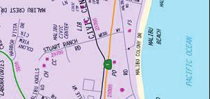


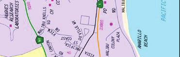
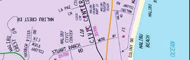
5 SOURCE: Overland Traffic Consultants, Inc., July 2013 FIGURE Study Area Intersections /14
6 In the immediate Project vicinity, the PCH Traffic Safety Evaluation notes that the collision rate at the intersection of Malibu Canyon Road with PCH is the second highest in the City. Malibu Canyon Road carries the highest volume of traffic of any surface street in the City and regularly experiences southbound left turn vehicle queues of 0.5 mile in length, which reach from the intersection at PCH to (and sometimes beyond) the intersection with Civic Center Way. These queues exacerbate cut-through traffic past the schools and neighborhoods on Civic Center Way as motorists attempt to avoid delays associated with this queue. 3 The PCH Traffic Safety Evaluation also identifies an existing lack of storage capacity on Webb Way and the PCH left turn lanes, as well as poor signal timing and a lack of sidewalks on the north side of PCH. Additionally, at the intersection of Cross Creek Road and PCH, the report identifies westbound congestion, poor signal timing, and lack of a sidewalk on the south side of PCH as key concerns. Transit Service Public transportation in the study area is provided by the Metropolitan Transportation Authority (Metro). Metro route 534 operates along Civic Center Way adjacent to the project site. Metro weekday service on this route is provided by three eastbound and seven westbound buses during the morning peak hours, five eastbound and three westbound buses during the afternoon peak hours, with three buses in each direction during the Saturday mid-day peak hours. Traffic Study Intersections To ensure updated, consistent traffic counts to be used for each pending project, traffic volume data was collected in the summer of 2012 by National Data & Surveying Services, an independent third party data collection company hired by the City of Malibu for use in this study. Weekday traffic counts were conducted on Thursday, July 12 th from 7:00 to 9:00 AM and 4:00 to 6:00 PM. Weekend traffic counts were conducted on Saturday, July 14 th from 11:00 AM to 1:00 PM. The intersections analyzed in this study are listed below. Figure , Study Area Intersections, illustrates the location of the study intersections. An asterisk (*) identifies a CMP monitoring intersection. 1. Kanan Dume Road and Pacific Coast Highway * 2. Malibu Canyon Road and Pacific Coast Highway * 3 Left turns (southbound) from Malibu Canyon Road onto Civic Center Way are prohibited between 6:00 AM and 9:00 AM on weekdays (AM Peak hour). This measure was aimed at preventing cut through traffic, although exactly how effective the measure is has yet to be determined. Impact Sciences, Inc Whole Foods and the Park Shopping Center Project Draft EIR
7 3. Malibu Canyon Road and Civic Center Way 4. Webb Way/Stuart Ranch Road and Civic Center Way 5. Cross Creek Road and Civic Center Way 6. Webb Way and Pacific Coast Highway 7. Cross Creek Road and Pacific Coast Highway 8. Malibu Pier Signal and Pacific Coast Highway 9. Carbon Canyon Road and Pacific Coast Highway 10. Las Flores Canyon Road and Pacific Coast Highway * The street segments analyzed in this study are: (using July 2012, City of Malibu counts) 1. Pacific Coast Highway east of Cross Creek Road 2. Pacific Coast Highway west of Malibu Canyon Road 3. Malibu Canyon Road north of Civic Center Way The existing 2012 peak hour traffic volumes at each study intersection are illustrated in Figure , Existing 2012 Peak Hour Traffic Volumes Weekday AM Peak Hour, for the weekday morning peak hour, Figure , Existing 2012 Peak Hour Traffic Volumes Weekday PM Peak Hour, for the weekday afternoon peak hour and Figure , Existing 2012 Saturday Mid-Day Peak Hour, for the Saturday mid-day peak hour. The July 2012 counts were conducted when Pepperdine was in summer session, which has a lower student population than during their regular sessions (i.e., the fall, winter, and spring sessions). Consequently, while PCH is typically busiest during the summer, it is likely that more Pepperdine or student-associated vehicles may be expected during the regular sessions. However, even when Pepperdine is in regular session, the traffic volumes on PCH are greatest during the summer season. In accordance with the City s Traffic Impact Analysis Guidelines, the TIA did not include pedestrian or bicyclist counts. The traffic conditions analysis was conducted using the Intersection Capacity Utilization (ICU) method. The ICU method uses a ratio of the traffic volume over intersection capacity to establish the level of traffic congestions. This volume-to-capacity (V/C) ratio defines the proportion of an hour necessary to accommodate all the traffic moving through the intersection assuming all approaches were operating at full capacity. Impact Sciences, Inc Whole Foods and the Park Shopping Center Project Draft EIR
8 SOURCE: Overland Traffic Consultants, Inc., July 2013 FIGURE Existing 2012 Peak Hour Traffic Volumes Weekday AM Peak Hour /14
9 SOURCE: Overland Traffic Consultants, Inc., July 2013 FIGURE Existing 2012 Peak Hour Traffic Volumes Weekday PM Peak Hour /14
10 SOURCE: Overland Traffic Consultants, Inc., July 2013 FIGURE Existing 2012 Saturday Mid-Day Peak Hour /14
11 Intersection Operations Because traffic flow on arterials is most constrained at intersections, detailed traffic flow analyses focus on operating conditions of critical intersections during peak travel periods. The quality of service offered by any roadway can be described by measuring its level of service (LOS), a qualitative method for describing operational conditions within a traffic stream or at an intersection, generally in terms of such service measures as speed and travel time, freedom to maneuver, traffic interruptions, and comfort and convenience. In rating intersection operations, LOS A through F are used, where LOS A indicates free flow operations and LOS F indicates congested operations. The City, through its Traffic Impact Analysis Guidelines, considers LOS C as the minimum acceptable operating standard for intersections for signalized and unsignalized intersections in the City during peak hour traffic. The Transportation Research Board s (TRB) 2000 Highway Capacity Manual (HCM) is the standard used for evaluating all types of LOS (e.g., signalized, unsignalized, freeway intersections). The V/C ratio and the average control delay are used to determine intersection the LOS for signalized and unsignalized (e.g., stop sign controlled) intersections respectively. The LOS criteria for unsignalized intersections have different threshold values than those for signalized intersections primarily because drivers expect different levels of performance from different types of transportation facilities. The expectation is that a signalized intersection is designed to carry higher traffic volumes than an unsignalized intersection. Thus, a higher level of control-related delay is acceptable at a signalized intersection for the same LOS. The LOS criteria are summarized in Table , LOS Criteria for Signalized and Unsignalized Intersections. LOS was calculated for the area intersections using the ICU and HCM procedures to calculate the V/C ratios and delay values for existing traffic conditions at each TIA intersection. Existing signalized intersections in the project area generally operate at acceptable stable conditions of LOS C or better (refer to Table Existing Traffic Conditions Summary; see Figure through Figure ). Two intersections currently operate at LOS C during the weekday PM peak hours, while all other signalized intersections operating at LOS A or B. During the weekend peak hour four intersections operate at LOS C, while all other signalized intersections operate at LOS A or B. Impact Sciences, Inc Whole Foods and the Park Shopping Center Project Draft EIR
12 Table LOS Criteria for Signalized and Unsignalized Intersections LOS Description Signalized (V/C Ratio) Unsignalized Average Control Delay (seconds) A Free flow conditions with low traffic density <10 B A stable flow of traffic >10 15 C D E F Light congestion but stable, occasional backups behind left-turning vehicles Approaching instability, drivers are restricted, vehicles may be required to wait through more than one signal cycle At or near capacity with long queuing for leftturning vehicles. Blockage of intersection may occur if traffic signal does not provide for protected turning movements. Jammed conditions with stoppages of long distances > > >35 50 >1.000 >50 Source: Overland Traffic Consultants, 2015 Table Existing Traffic Conditions Summary Weekday Weekend Mid-Day AM Peak Hour PM Peak Hour No. Intersection V/C (Delay) LOS V/C (Delay) LOS V/C (Delay) LOS 1. Kanan Dume Rd. & Pacific Coast Hwy A B C 2. Malibu Canyon Rd. & Pacific Coast Hwy B B C 3. Malibu Canyon Rd. & Civic Center Way A A A 4. Webb Way & Civic Center Way sec. B sec. C 9.73 sec A 5. Cross Creek Rd. & Civic Center Way 7.80 sec. A 8.99 sec. A 9.10 sec A 6. Webb Way & Pacific Coast Hwy A B C 7. Cross Creek Rd. & Pacific Coast Hwy A C C 8. Malibu Pier Signal & Pacific Coast Hwy A B B 9. Carbon Canyon Rd. & Pacific Coast Hwy A B B 10. Las Flores Canyon Rd. & Pacific Coast Hwy A B B Source: Overland Traffic Consultants, 2015 Impact Sciences, Inc Whole Foods and the Park Shopping Center Project Draft EIR
13 REGULATORY FRAMEWORK Federal Regulations Americans with Disabilities Act of 1990: Titles I, II, III, and V of the Americans with Disabilities Act (ADA) have been codified in Title 42 of the United States Code, beginning at Section Title III prohibits discrimination on the basis of disability in places of public accommodation (i.e., businesses and non-profit agencies that serve the public) and commercial facilities (i.e., other businesses). This regulation includes Appendix A to Part 36, Standards for Accessible Design, which establishes minimum standards for ensuring accessibility when designing and constructing a new facility or altering an existing facility. Examples of key guidelines include detectable warning for pedestrians entering traffic where there is no curb, a clear zone of 48 inches for the pedestrian travelway, and a vibration-free zone for pedestrians. State Regulations Traffic analysis in the State of California is guided by policies and standards set at the state level by the California Department of Transportation (Caltrans) and the local jurisdictions. The proposed project is within the City s jurisdiction and, therefore, subject to adopted City transportation policies and guidelines, which are consistent with Caltrans policies and standards. Furthermore, Caltrans retains jurisdiction over PCH in Malibu and would be responsible for any permitting related to the highway. In addition, seven of the intersections analyzed are located on PCH, which is part of the Los Angeles County CMP. Local Regulations City of Malibu General Plan The City of Malibu s General Plan provides the following goals and policies related to transportation: Land Use Element LU Policy The City shall avoid improvements which create a suburban atmosphere such as sidewalks and street lights. Conservation Element C Goal 1: Safe, environmentally sensitive and efficient transportation for the City. C Policy Where level of service at signalized intersections and roadways is below LOS C, the City shall ensure that proposed development maintains the then current Impact Sciences, Inc Whole Foods and the Park Shopping Center Project Draft EIR
14 LOS. Where LOS at signalized intersections and roadways is at LOS C or above, the City shall ensure that proposed development: (1) does not cause a degradation of LOS greater than or equal to 2 percent in the circumstances set forth in Land Use Implementation Measure 70; and (2) does not degrade LOS below LOS C. C Policy The City shall utilize sound traffic engineering and enforcement principles to safely regulate traffic and improve traffic flow. C Policy The City shall improve traffic flow through procedural improvements. C Policy The City shall reduce peak-time traffic. C Policy The City shall promote a balanced and integrated transportation system and reduce dependence on the automobile. C Policy The City shall encourage the use of alternative modes of transportation. C Policy The City shall develop year round local and regional public transportation. C Policy The City shall develop bikeways, pedestrian walkways, and equestrian paths in areas that can safely accommodate them. C Policy The City shall require sufficient off-street parking. City of Malibu Local Coastal Program The City lies entirely within with the California Coastal Zone, as defined by the California Coastal Act. The Coastal Act requires that its goals and policies be implemented by local government through the Local Coastal Program (LCP) process. The LCP is composed of two plans: the Land Use Plan (LUP) and the Local Implementation Plan (LIP). The LCP was adopted by the California Coastal Commission on September 13, Land Use Plan The LUP has several policies regarding circulation and traffic. The policies relevant to the proposed project include: Impact Sciences, Inc Whole Foods and the Park Shopping Center Project Draft EIR
15 LUP Policy 7.3: Improvements to existing public roads shall be permitted as necessary for public safety and to improve access to recreation areas where such improvements are consistent with all policies of the LCP. LUP Policy 7.4: Improvements to major road intersections for public safety or increase vehicle capacity shall be permitted, as necessary, in existing developed areas and where such improvements are sited and designed to be consistent with all policies of the LCP. LUP Policy 7.12: Restrictions on or elimination of existing on-street public parking on PCH and adjacent side-streets shall not be permitted unless a comparable number of replacement parking spaces are provided in the immediate vicinity and it is demonstrated that such restrictions or elimination will not adversely impact public access to the shoreline. Local Implementation Plan The LIP implements the policies of the LUP of the LCP. The implementation measures governing traffic and circulation under various sections of the LIP are as follows: Section 3.12 The purpose of the Parking Regulations section of the LIP is to ensure adequate off-street parking facilities in conjunction with any residential, commercial, or other use or development. These standards provided in the section should be considered the minimum required for preserving the public health, safety, and welfare. LIP Section , related to specific parking requirements, details parking requirements in accordance with the list of uses. LIP Section provides development standards for parking facilities. Apart from these parking regulations, there are no other implementation actions in the LIP pertaining to traffic and circulation. City of Malibu Municipal Code The Malibu Municipal Code (MMC) contains the laws of the City. Title 17 of the MMC specifically discusses the zoning regulations pertaining to new development. Chapter pertains to off-street parking and loading requirements, including the following, which apply to all parking areas with six or more spaces: Impact Sciences, Inc Whole Foods and the Park Shopping Center Project Draft EIR
16 (C)(3) Screening. Parking areas shall be screened from view from all designated highways (E) Landscaping. 1. A landscaped planter bed of at least 5 feet in width with a 6-inch-high cement concrete berm shall be installed along the entire perimeter except for those areas devoted to perpendicular access ways; 2. A minimum of 5 percent of the paved parking area shall be devoted to interior planting areas. Extensive use of trees is encouraged. All planting areas shall be at least 3-feet-wide. Perimeter planting shall not be considered part of this required interior planting; and 3. Where topography and gradient allow, parking lots should be depressed and/or screened from view by landscaped berms and hedges (F) Lighting. Lighting, where provided to illuminate a parking area, shall be hooded and so arranged and controlled so as not to cause nuisance either to highway traffic or to adjacent properties. ENVIRONMENTAL IMPACTS Thresholds of Significance The following thresholds for determining the significance of impacts related to transportation are contained in the environmental checklist form contained in Appendix G of the most recent update of the California Environmental Quality Act (CEQA) Statutes and Guidelines. Impacts related to aesthetics are considered significant if the proposed project would: Conflict with an applicable plan, ordinance or policy establishing measures of effectiveness for the performance of the circulation system, taking into account all modes of transportation including mass transit and non-motorized travel and relevant components of the circulation system, including but not limited to intersections, streets, highways and freeways, pedestrian and bicycle paths, and mass transit. The following significance thresholds for determining transportation and traffic impacts were identified by the City. The City considers a traffic impact to be potentially significant if the related increases in the V/C ratio value equals or exceeds adopted thresholds for signalized intersections or unsignalized intersections (refer to Tables and ). Additionally, a significant traffic impact for an arterial street would occur if the V/C ratio on a CMP roadway segment operating at an unacceptable LOS (i.e., LOS D, E, or F) increases by 0.05 or more. Impact Sciences, Inc Whole Foods and the Park Shopping Center Project Draft EIR
17 Table Significant Impact Criteria (Signalized Intersections) LOS Final V/C Value Increase in V/C Value C > or more D > or more E, F 0.91 or more or more Source: Overland Traffic Consultants, 2015 Table Significant Traffic Impact Criteria (Un-signalized Intersections) 1 Degrades the Level of Service (LOS) at an un-signalized intersection to an unacceptable level of Service (LOS D or worse); or 2 Increases delay at an un-signalized intersection operating at an unacceptable level by five or more seconds; or 3. Results in satisfying the most recent California Manual on Uniform Traffic Control Devices (CAMUTCD) peak hour volume warrant or other warrants for traffic signal installation at the intersection. Source: Overland Traffic Consultants, 2015 Conflict with an applicable congestion management program, including, but not limited to level of service standards and travel demand measures, or other standards established by the County congestion management agency for designated roads or highways? Result in a change in air traffic patterns, including either an increase in traffic levels or a change in location that results in substantial safety risks. Substantially increase hazards due to a design feature (e.g., sharp curves or dangerous intersections) or incompatible uses (e.g., farm equipment). Result in inadequate emergency access. Conflict with adopted policies, plans, or programs regarding public transit, bicycle, or pedestrian facilities, or otherwise decrease the performance or safety of such facilities. Methodology The traffic impacts of the proposed project were evaluated in the TIA using trip generation, trip distribution, and trip assignment for four scenarios including a No Project Scenario and a Plus Project Scenario for Existing Year (2012) and Future Years (2017 and 2030) scenarios. Estimates of projectgenerated traffic were calculated using the industry standard 2012 traffic generation rates developed by the Institute of Transportation Engineers (ITE). The estimated project directional trip distribution was based on the project area roadway network, traffic flow patterns in and out of the project area, and other Impact Sciences, Inc Whole Foods and the Park Shopping Center Project Draft EIR
18 traffic studies recently prepared for the general area. Using the traffic assignment at each intersection and the estimated project traffic generation, peak hour traffic volumes at each study location were calculated for each peak hour and for each scenario. This estimated assignment of the project traffic flow provided the information necessary to analyze the potential project traffic impacts. Future traffic volume projections have been developed to analyze the traffic conditions after completion of other planned land developments including the proposed project for two scenarios: future study years 2017 and In addition to the traffic generated by the related project list, other projects outside the study area or projects unknown at this time may contribute to the traffic volume in the area. To account for this outside influence, an ambient annual growth factor (1.5 percent) has been applied to the existing 2012 traffic counts to establish the 2017 study year. This growth factor is based on the growth rates in the City TIA Guidelines for the 2017 study year. The use of both the related project traffic volume growth and the ambient growth factor provides a conservative estimate of future traffic growth in the study area for Los Angeles Congestion Management Program Analysis The adopted Los Angeles Congestion Management Program (CMP) traffic growth forecasts for 2030 have been applied to develop the future traffic volumes for In addition to the CMP growth, the same current cumulative projects list has been included. Therefore, the total growth for the 2030 project impact analysis consists of the CMP growth rate (9 percent) plus the current related projects per the City of Malibu s cumulative projects list. Adding the project traffic to the two future without project conditions provides the information necessary to calculate the future cumulative project traffic impacts at the study intersections for each future scenario. Impact Analysis Threshold Conflict with an applicable plan, ordinance or policy establishing measures of effectiveness for the performance of the circulation system, taking into account all modes of transportation including mass transit and non-motorized travel and relevant components of the circulation system, including but not limited to intersections, streets, highways and freeways, pedestrian and bicycle paths, and mass transit. A significant impact would occur if the proposed project exceeded adopted thresholds for signalized intersections or unsignalized intersections (refer to Tables and ) or result in V/C ratio on a CMP roadway segment operating at an unacceptable LOS (i.e., LOS D, E, or F) increases by 0.05 or more. Impact Sciences, Inc Whole Foods and the Park Shopping Center Project Draft EIR
19 Existing (2012) Conditions As shown in Table , Existing Plus Project Traffic Conditions, during the Existing Year (2012) all of the study intersections operate at an acceptable LOS. The traffic estimates show that the proposed project would generate 2,290 weekday vehicle trips with 101 AM peak hour trips and 154 PM peak hour trips. In addition, the proposed project would generate an estimate 2,528 weekend trips with 226 weekend midday trips. Project traffic volumes are shown in Figure , Project Traffic Volume Weekday AM Peak Hour, Figure , Project Traffic Volume Weekday PM Peak Hour, and Figure , Project Traffic Volume Saturday Mid-Day Peak Hour Table Existing Plus Project Traffic Conditions Existing With Project No. Intersection Peak Hour V/C (Delay) LOS V/C (Delay) LOS Impact 1. Kanan Dume Rd. & Weekday AM A A Pacific Coast Hwy. Weekday PM B B Saturday Mid-day C C Malibu Canyon Rd. & Weekday AM B B Pacific Coast Hwy. Weekday PM B B Saturday Mid-day C C Malibu Canyon Rd. & Weekday AM A A Civic Center Way Weekday PM A A Saturday Mid-day A A Webb Way / Stuart Ranch Weekday AM sec. B sec. B sec. Road & Civic Center Way Weekday PM sec. C sec. C sec. Saturday Mid-day 9.73 sec. A sec. B sec. 5. Cross Creek Rd. & Weekday AM 7.80 sec. A 8.00 sec. A sec. Civic Center Way Weekday PM 8.99 sec. A 9.54 sec. A sec. Saturday Mid-day 9.10 sec. A sec. A sec. 6. Webb Way & Weekday AM A A Pacific Coast Hwy. Weekday PM B B Saturday Mid-day C C Cross Creek Rd. & Weekday AM A B Pacific Coast Hwy. Weekday PM C D * Saturday Mid-day C D * 8. Malibu Pier Signal & Weekday AM A A Pacific Coast Hwy. Weekday PM B B Saturday Mid-day B B Carbon Canyon Rd. & Weekday AM A A Pacific Coast Hwy. Weekday PM B B Saturday Mid-day B B Las Flores Canyon Rd. & Weekday AM A A Pacific Coast Hwy. Weekday PM B B Saturday Mid-day B B Note: All-Way Stop Control Delay in Seconds Per Vehicle; * Denotes significant traffic impact. Source: Overland Traffic Consultants, 2015 Impact Sciences, Inc Whole Foods and the Park Shopping Center Project Draft EIR
20 As shown in Table , one study intersection would impacted by the proposed project traffic volume. Using the criteria in the City s TIA Guidelines, it has been determined that the change in traffic flow generated by the proposed project would significantly impact the intersection of Cross Creek Road and Pacific Coast Highway (study intersection #7) during the weekday afternoon and Saturday mid-day peak prior to the implementation of traffic mitigation measures. Existing plus project traffic volumes are shown in Figure , Existing (2012) + Project Traffic Volume Weekday AM Peak Hour, Figure , Existing (2012) + Project Traffic Volume Weekday PM Peak Hour, and Figure , Existing (2012) + Project Traffic Volume Saturday Mid-Day Peak Hour Future Year (2017 and 2030) Conditions Future traffic volume projections were developed to analyze the traffic conditions after completion of other planned land developments including the proposed project for two scenarios: future study years 2017 and In addition to the traffic generated by the related project list, other projects outside the study area or projects unknown at this time may contribute to the traffic volume in the area. To account for this outside influence, an ambient annual growth factor (1.5 percent) has been applied to the existing 2012 traffic counts to establish the 2017 study year. This growth factor is based on the growth rates in the City TIA Guidelines for the 2017 study year. The use of both the related project traffic volume growth and the ambient growth factor provides a conservative estimate of future traffic growth in the study area for Traffic Volumes are shown in Figure , Future (2017) Traffic Volume Without Project Weekday AM Peak Hour, Figure , Future (2017) Traffic Volume Without Project Weekday PM Peak Hour, and Figure , Future (2017) Traffic Volume Without Project Saturday Mid-Day Peak Hour. Adding the project traffic to the two future without project conditions provides the information necessary to calculate the future cumulative project traffic impacts at the study intersections for each future scenario. Table , Future (2017) + Project Traffic Conditions shows the estimated project traffic impacts for the 2017 study year. Future cumulative 2017 peak hour traffic volumes with the proposed project are shown in Figure , Future (2017) Traffic Volume + Project - Weekday AM Peak Hour, Figure , Future (2017) Traffic Volume +Project - Weekday PM Peak Hour, and Figure , Future (2017) Traffic Volume + Project - Saturday Mid-Day Peak Hour. Impact Sciences, Inc Whole Foods and the Park Shopping Center Project Draft EIR
21 SOURCE: Overland Traffic Consultants, Inc., July 2013 FIGURE Project Traffic Volume Weekday AM Peak Hour /14
22 SOURCE: Overland Traffic Consultants, Inc., July 2013 FIGURE Project Traffic Volume Weekday PM Peak Hour /14


23 SOURCE: Overland Traffic Consultants, Inc., July 2013 FIGURE Project Traffic Volume Saturday Mid-Day Peak Hour /14
24 SOURCE: Overland Traffic Consultants, Inc., July 2013 FIGURE Existing (2012) + Project Traffic Volume Weekday AM Peak Hour /14
25 SOURCE: Overland Traffic Consultants, Inc., July 2013 FIGURE Existing (2012) + Project Traffic Volume Weekday PM Peak Hour /14
26 SOURCE: Overland Traffic Consultants, Inc., July 2013 FIGURE Existing (2012) + Project Traffic Volume Saturday Mid-Day Peak Hour /14
27 SOURCE: Overland Traffic Consultants, Inc., January 2015 FIGURE Future (2017) Traffic Volume Without Project Weekday AM Peak Hour /15
28 SOURCE: Overland Traffic Consultants, Inc., January 2015 FIGURE Future (2017) Traffic Volume Without Project Weekday PM Peak Hour /15
29 SOURCE: Overland Traffic Consultants, Inc., January 2015 FIGURE Future (2017) Traffic Volume Without Project Saturday Mid-Day Peak Hour /15
30 SOURCE: Overland Traffic Consultants, Inc., January 2015 FIGURE Future (2017) Traffic Volume + Project Weekday AM Peak Hour /15
31 SOURCE: Overland Traffic Consultants, Inc., January 2015 FIGURE Future (2017) Traffic Volume +Project Weekday PM Peak Hour /15
32 SOURCE: Overland Traffic Consultants, Inc., January 2015 FIGURE Future (2017) Traffic Volume + Project Saturday Mid-Day Peak Hour /15
33 Based on the 2017 analysis, three intersections are significantly impacted. The intersections are: Malibu Canyon Road and Pacific Coast Highway during the Saturday mid-day peak hour; Pacific Coast Highway and Webb Way during the Saturday mid-day peak hour; and Pacific Coast Highway and Cross Creek Road during the weekday afternoon peak hour and the Saturday mid-day peak hour. Table Future (2017) + Project Traffic Conditions Without Project With Project No. Intersection Peak Hour V/C (Delay) LOS V/C (Delay) LOS Impact 1. Kanan Dume Rd. & Weekday AM A A Pacific Coast Hwy. Weekday PM C C Saturday Mid-day C C Malibu Canyon Rd. & Weekday AM C C Pacific Coast Hwy. Weekday PM D D Saturday Mid-day E E * 3. Malibu Canyon Rd. & Weekday AM A A Civic Center Way Weekday PM A A Saturday Mid-day A A Webb Way/Stuart Ranch Weekday AM sec. B sec. B sec. Road & Civic Center Way Weekday PM sec. E sec. E sec. Saturday Mid-day sec. B sec. B sec. 5. Cross Creek Rd. & Weekday AM 8.98 sec. A 9.34 sec. B sec. Civic Center Way Weekday PM sec. B sec. B sec. Saturday Mid-day sec. B sec. C sec. 6. Webb Way & Weekday AM A A Pacific Coast Hwy. Weekday PM C D Saturday Mid-day D D * 7. Cross Creek Rd. & Weekday AM B B Pacific Coast Hwy. Weekday PM E E * Saturday Mid-day F F * 8. Malibu Pier Signal & Weekday AM B B Pacific Coast Hwy. Weekday PM C C Saturday Mid-day C C Carbon Canyon Rd. & Weekday AM A B Pacific Coast Hwy. Weekday PM C C Saturday Mid-day C D Las Flores Canyon Rd. Weekday AM B B Pacific Coast Hwy. Weekday PM D D Saturday Mid-day D D Note: All-Way Stop Control Delay in Seconds Per Vehicle; * Denotes significant traffic impact. Source: Overland Traffic Consultants, January 2015 Impact Sciences, Inc Whole Foods and the Park Shopping Center Project Draft EIR
34 Mitigation Measures The proposed project shall implement the following mitigation measures for project related traffic impacts. Existing Plus Project : The project applicant shall contribute its pro-rata share of the costs associated with the intersection improvements required at Pacific Coast Highway and Cross Creek Road, which are currently underling review by the City of Malibu Planning Department (CDP No ). These intersection improvements shall consist of the construction of an additional westbound right-turn lane along Pacific Coast Highway and incremental roadway widening west and east of the Pacific Coast Highway/Cross Creek Road to provide additional right-turn capacity. Figure , Traffic Mitigation Plan, Cross Creek Road & Pacific Coast Highway, illustrates the design of the Cross Creek Road/Pacific Coast Highway intersection improvement. The pro-rata share of the improvement costs shall be determined by the City of Malibu prior to the issuance of building permits. The City shall verify that all pro-rata funds have been received for the improvements prior to issuance of building permits. Additionally, the City shall verify that the improvements have been constructed prior to final Planning Department inspection. Future (2017) Plus Project : The project applicant shall contribute its pro-rata share of the costs associated with roadway improvements at the intersection of Malibu Canyon Road and Pacific Coast Highway. The improvements shall consist of restriping the south leg of the intersection to include a left-turn lane, one through lane and one right-turn lane. In addition, the project applicant shall fund traffic signal improvements for the intersection consisting of installing a northbound right turn overlap phase to run concurrently with the westbound left turn phase. Figure , Traffic Mitigation Plan, Malibu Canyon Road & Pacific Coast Highway, illustrates the design of the Malibu Canyon Road and Pacific Coast Highway intersection improvements. The pro-rata share of the improvement costs shall be determined by the City of Malibu prior to the issuance of building permits. The City shall verify that all pro-rata funds have been received for the improvements prior to issuance of building permits. Additionally, the City shall verify that the improvements have been constructed prior to final Planning Department inspection. Impact Sciences, Inc Whole Foods and the Park Shopping Center Project Draft EIR

35 SOURCE: Overland Traffic Consultants, Inc., July /14 FIGURE Conceptual Traffic Mitigation, Cross Creek Road & Pacific Coast Highway

36 SOURCE: Overland Traffic Consultants, Inc., July /14 FIGURE Conceptual Traffic Mitigation, Malibu Canyon Road & Pacific Coast Highway
37 3.13-3: The project applicant shall fund the construction of dual eastbound left-turn lanes at the eastbound approach to the intersection of Pacific Coast Highway and Webb Way. Prior to construction, all applicable permits shall be obtained from Caltrans. Figure , Traffic Mitigation Plan, Webb Way & Pacific Coast Highway, illustrates the design of the Pacific Coast Highway intersection improvements. The pro-rata share of the improvement costs shall be determined by the City of Malibu prior to the issuance of building permits. The City shall verify that all pro-rata funds have been received for the improvements prior to issuance of building permits. Additionally, the City shall verify that the improvements have been constructed prior to final Planning Department inspection. Residual Impacts As shown in Table , Existing (2012) Traffic Conditions with Project + Mitigation below, the impact at Cross Creek Road and Pacific Coast Highway would be mitigated with the implementation of Mitigation Measure Table Existing (2012) Traffic Conditions with Project + Mitigation Existing With Project + Mitigation No. Intersection Peak Hour V/C (Delay) LOS V/C (Delay) LOS Impact 7. Cross Creek Rd. & Weekday AM A B Pacific Coast Hwy. Weekday PM C C Saturday Mid-day C C Note: All-Way Stop Control Delay in Seconds Per Vehicle; * Denotes significant traffic impact. Source: Overland Traffic Consultants, January 2015 As shown in Table , Future (2017) Traffic Conditions With Project + Mitigation, below, the impact at the intersections of Malibu Canyon Road and Pacific Coast Highway and the intersection of Webb Way and Pacific Coast Highway would be mitigated with the implementation of Mitigation Measure and Mitigation Measure Implementation of Mitigation Measure would mitigate impacts at the intersection of Cross Creek Road and Pacific Coast Highway. Impact Sciences, Inc Whole Foods and the Park Shopping Center Project Draft EIR
38 Table Future (2017) Traffic Conditions With Project + Mitigation Without Project With Project + Mitigation No. Intersection Peak Hour V/C (Delay) LOS V/C (Delay) LOS Impact 2. Malibu Canyon Rd Weekday AM C C Pacific Coast Hwy. Weekday PM D D Saturday Mid-day E E Webb Way & Weekday AM A A Pacific Coast Hwy Weekday PM D D Saturday Mid-day D D Cross Creek Road & Weekday AM B B Pacific Coast Hwy Weekday PM E D Saturday Mid-day F E Note: All-Way Stop Control Delay in Seconds Per Vehicle; * Denotes significant traffic impact. Source: Overland Traffic Consultants, January 2015 Threshold Conflict with an applicable congestion management program, including, but not limited to level of service standards and travel demand measures, or other standards established by the County congestion management agency for designated roads or highways. The Congestion Management Program (CMP) was adopted to regulate and monitor regional traffic growth and transportation improvement programs. The CMP designates a transportation network which includes all state highways and some arterials within the County of Los Angeles. If the level of service standard deteriorates on the CMP network, then the local jurisdiction must prepare a deficiency plan to be in conformance with the LA County CMP. The intent of the CMP is to provide information to decision makers to assist in the allocation of transportation funds through the State Transportation Improvement Program (STIP) process. A CMP traffic impact analysis is required if a project will add 150 or more trips to a freeway, in either direction during either the AM or PM weekday peak hour. An analysis is also required at all CMP monitoring intersections where a project would add 50 or more peak hour trips. All of the CMP intersections listed below are analyzed in this study. Las Flores Canyon Road and Pacific Coast Highway Malibu Canyon Road and Pacific Coast Highway Kanan Dume Road and Pacific Coast Highway Impact Sciences, Inc Whole Foods and the Park Shopping Center Project Draft EIR

39 SOURCE: Overland Traffic Consultants, Inc., July 2013 FIGURE Conceptual Traffic Mitigation, Webb Way & Pacific Coast Highway /14
Traffic Impact Analysis
 Traffic Impact Analysis TRAFFIC IMPACT ANALYSIS FOR A PROPOSED NEIGHBORHOOD SHOPPING CENTER Civic Center Way and Cross Creek Road City of Malibu Prepared for: Goldman Firth Rossi Architects Prepared by:
V. ENVIRONMENTAL IMPACT ANALYSIS K. TRANSPORTATION AND CIRCULATION
 V. ENVIRONMENTAL IMPACT ANALYSIS K. TRANSPORTATION AND CIRCULATION ENVIRONMENTAL SETTING The following section is based on the Draft Traffic Circulation Study for the Malibu La Paz Project (Traffic Study),
3.9 - Transportation and Traffic
 Transportation and Traffic 3.9 - Transportation and Traffic This section describes the potential transportation and traffic effects of project implementation on the project site and its surrounding area.
Magnolia Place. Traffic Impact Analysis. Prepared for: City of San Mateo. Prepared by: Hexagon Transportation Consultants, Inc.
 Magnolia Place Traffic Impact Analysis Prepared for: City of San Mateo Prepared by: Hexagon Transportation Consultants, Inc. Updated January 4, 2010 Table of Contents 1. Introduction...1 2. Existing Conditions...6
TRAFFIC IMPACT ANALYSIS
 TRAFFIC IMPACT ANALYSIS FOR THE CHAMPAIGN UNIT#4 SCHOOL DISTRICT PROPOSED HIGH SCHOOL (SPALDING PARK SITE) IN THE CITY OF CHAMPAIGN Final Report Champaign Urbana Urbanized Area Transportation Study 6/24/2014
4.11 TRANSPORTATION 4.11 TRANSPORTATION Environmental Setting Intersection, Roadway, and Freeway Evaluation Methodology
 4.11 TRANSPORTATION This section describes the road transportation system in the vicinity of the proposed Project and the potential impacts to this system from the proposed Project. The analysis in this
5.3 TRAFFIC, CIRCULATION AND PARKING
 5.3 TRAFFIC, CIRCULATION AND PARKING This section is based upon the Downtown Lancaster Specific Plan Traffic Impact Analysis (April 2, 2008) and the Downtown Lancaster Specific Plan Parking Analysis (May
D.13 Transportation and Traffic
 This section addresses transportation and traffic issues and impacts related to the Proposed Project. Section D.13.1 provides a description of the affected environment for the Proposed Project. Applicable
Abrams Associates. Transportation Impact Analysis. City of Rocklin. Prepared for: David Mohlenbrok City of Rocklin 4081 Alvis Court Rocklin, CA 95677
 Transportation Impact Analysis Sierra College Boulevard Commercial Project City of Rocklin Prepared for: David Mohlenbrok City of Rocklin 081 Alvis Court Rocklin, CA 95677 Prepared by: 1875 Olympic Boulevard,
TABLE OF CONTENTS TABLE OF CONTENTS... I APPENDICES... III LIST OF EXHIBITS... V LIST OF TABLES... VII LIST OF ABBREVIATED TERMS...
 TABLE OF CONTENTS TABLE OF CONTENTS... I APPENDICES... III LIST OF EXHIBITS... V LIST OF TABLES... VII LIST OF ABBREVIATED TERMS... IX 1 INTRODUCTION... 1 1.1 Project Overview... 1 1.2 Analysis Scenarios...
Traffic Impact Analysis Chatham County Grocery Chatham County, NC
 Chatham County Grocery Chatham County, NC TABLE OF CONTENTS 1. INTRODUCTION... 1 1.1. Location and Study Area... 1 1.2. Proposed Land Use and Access... 2 1.3. Adjacent Land Uses... 2 1.4. Existing ways...
List of Attachments. Location Map... Site Plan... City of Lake Elsinore Circulation Element... City of Lake Elsinore Roadway Cross-Sections...
 List of Attachments Exhibits Location Map... Site Plan... City of Lake Elsinore Circulation Element... City of Lake Elsinore Roadway Cross-Sections... Existing Lane Geometry and Traffic Controls... Existing
 TRAFFIC IMPACT STUDY CANYON HILLS PROJECT LOS ANGELES, CALIFORNIA INTRODUCTION This traffic analysis has been conducted to identify and evaluate the potential traffic impacts of the proposed Canyon Hills
THIS PAGE LEFT BLANK INTENTIONALLY
 GA SR 25 Spur at Canal Road Transportation Impact Analysis PREPARED FOR GLYNN COUNTY, GEORGIA 1725 Reynolds Street, Suite 300 Brunswick, Georgia 31520 PREPARED BY 217 Arrowhead Boulevard Suite 26 Jonesboro,
4. ENVIRONMENTAL IMPACT ANALYSIS 9. TRANSPORTATION AND TRAFFIC
 4. ENVIRONMENTAL IMPACT ANALYSIS 9. TRANSPORTATION AND TRAFFIC 4.9.1 INTRODUCTION The following section addresses the Proposed Project s impact on transportation and traffic based on the Traffic Study
6.14 Traffic and Circulation
 6.14 Traffic and Circulation 6.14.1 Introduction The analysis in this section summarizes the findings and recommendations presented in the "Marywood Development Traffic Impact Study, City of Orange, California"
4.11 TRANSPORTATION/CIRCULATION
 4.11 TRANSPORTATION/CIRCULATION This section was developed using information from a Traffic Analysis Report prepared for the project by OEG, Inc. (2010), the Paradiso del Mare Ocean and Inland Estates
TRAFFIC IMPACT STUDY And A TRAFFIC SIGNAL WARRANT ANALYSIS FOR A SENIOR LIVING AND APARTMENT DEVELOPMENT
 TRAFFIC IMPACT STUDY And A TRAFFIC SIGNAL WARRANT ANALYSIS FOR A SENIOR LIVING AND APARTMENT DEVELOPMENT DEERFIELD TOWNSHIP, WARREN COUNTY, OHIO Nantucket Circle and Montgomery Road () Prepared for: ODLE
SECTION 1 - TRAFFIC PLANNING
 SECTION 1 - TRAFFIC PLANNING 1.1 TRAFFIC OPERATIONS 1.1.1 Roadway Functional Classification The Multnomah County Comprehensive Framework Plan s Policy 34: Trafficways and the Functional Classification
CarMax Auto Superstore/ Reconditioning Center #6002 Murrieta, California
 CarMax Auto Superstore/ Reconditioning Center #6002 Murrieta, California TUSTIN 17782 17th Street Suite 200 Tustin, CA 92780-1947 714.665.4500 Fax: 714.665.4501 LOS ANGELES 145 S. Spring Street Suite 120
4.11 Transportation and Traffic
 4.11.1 Introduction This section evaluates whether implementation of the Russian River Estuary Management Project (Estuary Management Project) would result in potential adverse impacts related to transportation
Mission Street Medical Office Development
 reet Medical Office Development Traffic Impact Analysis Prepared for: Palo Alto Medical Foundation February 23, 2012 Hexagon Office: 7888 Wren Avenue, Suite B121 Gilroy, CA 95020 Hexagon Job Number: 11RD11
EAST AND SOUTH STREET CITY OF ANAHEIM, CALIFORNIA
 T R A F F I C I M P A C T A N A LY S I S EAST AND SOUTH STREET CITY OF ANAHEIM, CALIFORNIA April 217 T R A F F I C I M P A C T A N A LY S I S EAST AND SOUTH STREET CITY OF ANAHEIM, CALIFORNIA Submitted
4.13 TRANSPORTATION AND TRAFFIC
 4.13 This chapter describes the regulatory framework and existing conditions in the vicinity of the Project site related to transportation and traffic, and the potential impacts of the proposed Project
Access Location, Spacing, Turn Lanes, and Medians
 Design Manual Chapter 5 - Roadway Design 5L - Access Management 5L-3 Access Location, Spacing, Turn Lanes, and Medians This section addresses access location, spacing, turn lane and median needs, including
INTRODUCTION THOROUGHFARE SYSTEM CLASSIFICATIONS
 INTRODUCTION The thoroughfare plan will assist public officials in the development of a specialized system for efficient and safe movement of vehicular traffic while minimizing potential conflicts with
Highway 111 Corridor Study
 Highway 111 Corridor Study June, 2009 LINCOLN CO. HWY 111 CORRIDOR STUDY Draft Study Tea, South Dakota Prepared for City of Tea Sioux Falls Metropolitan Planning Organization Prepared by HDR Engineering,
Traffic Circulation Study for Neighborhood Southwest of Mockingbird Lane and Airline Road, Highland Park, Texas
 ARIZONA TEXAS NEW MEXICO OKLAHOMA February 13, 2015 Mr. Meran Dadgostar P.E., R.S. Town of Highland Park 4700 Drexel Dr. Highland Park, Texas 75205 Re: Traffic Circulation Study for Neighborhood Southwest
Traffic Impact Study WestBranch Residential Development Davidson, NC March 2016
 Traffic Impact Study WestBranch Residential Development Davidson, NC March 216 TRAFFIC IMPACT STUDY FOR THE WestBranch Residential Development LOCATED IN DAVIDSON, NC Prepared For: Lennar Carolinas, LLC
3.0 PROJECT DESCRIPTION
 The following section of the Draft EIR contains a description of the proposed Elk Grove Boulevard/SR 99 Interchange Modification project, consistent with the requirements of CEQA Guidelines Section 15124.
Figure 1: East West Connector Alignment Alternatives Concept Drawing
 Page 2 of 9 Figure 1: East West Connector Alignment Alternatives Concept Drawing The Montebello Drive extension will run north south and connect Wilsonville Road to the Boones Ferry Road to Brown Road
VIVA RETIREMENT COMMUNITIES OAKVILLE TRAFFIC IMPACT STUDY
 VIVA RETIREMENT COMMUNITIES OAKVILLE TRAFFIC IMPACT STUDY VIVA RETIREMENT COMMUNITIES OAKVILLE TRAFFIC IMPACT STUDY DECEMBER 2012 READ, VOORHEES & ASSOCIATES TORONTO, ONTARIO Read, Voorhees & Associates
Clackamas County Comprehensive Plan
 ROADWAYS The County s road system permits the movement of goods and people between communities and regions, using any of a variety of modes of travel. Roads provide access to virtually all property. They
Transportation Impact Study for Abington Terrace
 Transportation Impact Study for Abington Terrace Abington Township, Montgomery County, PA Sandy A. Koza, P.E., PTOE PA PE License Number PE059911 Prepared by McMahon Associates, Inc. 425 Commerce Drive,
Traffic Impact Analysis Walton Acres at Riverwood Athletic Club Clayton, NC
 Traffic Impact Analysis Walton Acres at Riverwood Athletic Club Clayton, NC 1. TABLE OF CONTENTS INTRODUCTION...1 1.1. Site Location and Study Area...1 1.2. Proposed Land Use and Site Access...2 1.3.
Highway 49, Highway 351 and Highway 91 Improvements Feasibility Study Craighead County
 Highway 49, Highway 351 and Highway 91 Improvements Feasibility Study Craighead County Executive Summary March 2015 Highway 49, Highway 351 and Highway 91 Improvements Feasibility Study Craighead County
Chapter 4 Traffic Analysis
 Chapter 4 Traffic Analysis PURPOSE The traffic analysis component of the K-68 Corridor Management Plan incorporates information on the existing transportation network, such as traffic volumes and intersection
Implementing Complete Streets in Ottawa. Project Delivery Process and Tools Complete Streets Forum 2015 October 1, 2015
 Implementing Complete Streets in Ottawa October 1, 2015 The Essentials Complete Streets Implementation Framework will become part of the routine delivery of City transportation projects Approach uses every
ALLEY 24 TRAFFIC STUDY
 ALLEY 24 TRAFFIC STUDY in City of Frostburg, Maryland January 2013 3566 Teays Valley Road Hurricane, WV Office: (304) 397-5508 www.denniscorporation.com Alley 24 Traffic Study January 2013 Frostburg, Maryland
Recommended Roadway Plan Section 2 - Land Development and Roadway Access
 Recommended Roadway Plan Section 2 - Land Development and Roadway Access SECTION 2 Land Development and Roadway Access 2.1 Land Use and Access Management The Federal Highway Administration (FHWA) defines
TRAFFIC IMPACT ANALYSIS. Photo here CAL MET ROYAL MRF EXPANSION. City of Paramount, CA. arch beach C O N S U L T I N G.
 TRAFFIC IMPACT ANALYSIS z Photo here CAL MET ROYAL MRF EXPANSION City of Paramount, CA arch beach C O N S U L T I N G June 23, 214 TRAFFIC IMPACT ANALYSIS CAL MET ROYAL MATERIALS RECOVERY FACILITY (MRF)
OTTAWA TRAIN YARDS PHASE 3 DEVELOPMENT CITY OF OTTAWA TRANSPORTATION IMPACT STUDY. Prepared for:
 OTTAWA TRAIN YARDS PHASE 3 DEVELOPMENT CITY OF OTTAWA TRANSPORTATION IMPACT STUDY Prepared for: The Ottawa Train Yards Inc. 223 Colonnade Road South, Suite 212 Nepean, Ontario K2E 7K3 January 17, 2012
Focused Traffic Analysis for the 200 Nellen Avenue Project
 March 13, 2017 Mr. Phil Boyle Town of Corte Madera 300 Tamalpais Drive Corte Madera, CA 94976-0159 Focused Traffic Analysis for the 200 Nellen Avenue Project Dear Mr. Boyle; W-Trans has completed a focused
Overland Traffic Consultants, Inc. October 15, Mr. Bruce McBride Project Delivery Analysts, LLC Shawnee Street Moorpark, CA 93021
 Overland Traffic Consultants 952 Manhattan Beach Boulevard, Suite #100 Manhattan Beach, CA 90266 Phone (661) 799-8423 E-mail: otc@overlandtraffic.com October 15, 2015 Mr. Bruce McBride Project Delivery
Access Management Regulations and Standards
 Access Management Regulations and Standards January 2014 Efficient highway operation Reasonable property access Concept of Access Management The way to manage access to land development while preserving
Traffic Impact Study. Westlake Elementary School Westlake, Ohio. TMS Engineers, Inc. June 5, 2017
 TMS Engineers, Inc. Traffic Impact Study Westlake Elementary School Westlake, Ohio June 5, 2017 Prepared for: Westlake City Schools - Board of Education 27200 Hilliard Boulevard Westlake, OH 44145 TRAFFIC
Traffic Study of Fuller Street, Cady Street, West Street and West Avenue. Final Report
 Traffic Study of Fuller Street, Cady Street, West Street and West Avenue Final Report July 2005 Prepared for: Town of Ludlow Prepared by: Pioneer Valley Planning Commission 26 Central Street West Springfield,
4.10 TRANSPORTATION AND CIRCULATION
 4.10 TRANSPORTATION AND CIRCULATION PURPOSE The section discusses the potential impacts to traffic and circulation as a result of the implementation of the proposed Via Princessa East Extension, which
IV. Environmental Impact Analysis B.3 Pedestrian Circulation and Bicycle and Pedestrian Safety
 IV. Environmental Impact Analysis B.3 Pedestrian Circulation and Bicycle and Pedestrian Safety 1. Introduction This section analyzes the potential impacts of the Project on pedestrian circulation and bicycle
CITY OF LOMITA CITY COUNCIL REPORT
 CITY OF LOMITA CITY COUNCIL REPORT TO: FROM: City Council Ryan Smoot, City Manager Item No. SCH 12 PREPARED BY: Mark A. McAvoy, P.E., Public Works Director/City Engineer MEETING DATE: August 1, 2017 SUBJECT:
M-58 HIGHWAY ACCESS MANAGEMENT STUDY Mullen Road to Bel-Ray Boulevard. Prepared for CITY OF BELTON. May 2016
 M-58 HIGHWAY ACCESS MANAGEMENT STUDY Prepared for CITY OF BELTON By May 2016 Introduction Missouri State Highway 58 (M-58 Highway) is a major commercial corridor in the City of Belton. As development has
Appendix B. Environmental Resource Technical Memorandum. Assessment on Travel Pattern and Access Impacts
 Appendix B Environmental Resource Technical Memorandum Assessment on Travel Pattern and Access Impacts TECHNICAL MEMORANDUM ENVIRONMENTAL RE-EVALUATION FOR UNION STATION TO OAK CLIFF DALLAS STREETCAR To:
4.0 TRAFFIC IMPACT STUDIES
 SECTION 4 4.0 TRAFFIC IMPACT STUDIES 4.1 TRAFFIC IMPACT STUDY REQUIREMENTS The City has established Traffic Impact Study (TIS) requirements for the purpose of ensuring that both the quantitative and qualitative
TRAFFIC ASSESSMENT River Edge Colorado
 TRAFFIC ASSESSMENT River Edge Colorado Submitted by: Fehr & Peers 621 17th Street, Ste. 231 Denver, CO 8293 (33) 296-43 December, 21 App. M-2 Traffic Assessment River Edge Colorado December 21 TABLE OF
TABLE TRAFFIC ANALYSIS SCENARIOS
 4.11 TRANSPORTATION The potential traffic impacts of the proposed project are evaluated in the Buena Park Beach/Orangethorpe Mixed Use Project Traffic Analysis (Traffic Analysis) by Austin-Foust Associates
TRANSPORTATION ANALYSIS REPORT US Route 6 Huron, Erie County, Ohio
 TRANSPORTATION ANALYSIS REPORT US Route 6 Huron, Erie County, Ohio December 12, 2012 Prepared for: The City of Huron 417 Main Huron, OH 44839 Providing Practical Experience Technical Excellence and Client
Los Coyotes Country Club Development Plan Traffic Impact Analysis
 Los Coyotes Country Club Development Plan Traffic Impact Analysis Prepared For: Phil Martin Associates 2073007450 Los Coyotes Country Club Development Plan Traffic Impact Analysis June 19, 2014 Prepared
Chapter 16: Traffic and Parking A. INTRODUCTION
 Chapter 6: Traffic and Parking A. ITRODUCTIO This chapter examines the potential traffic and parking impacts of the proposed Fresh Kills Park roads. The analysis of transit and pedestrians is presented
REVIEW OF LOCAL TRAFFIC FLOW / LONG RANGE PLANNING SOLUTIONS STUDY
 ITEM Town of Atherton TRANSPORTATION COMMITTEE STAFF REPORT TO: FROM: MEMBERS OF THE COMMITTEE ROBERT OVADIA, PUBLIC WORKS DIRECTOR DATE: FEBRUARY 12, 2019 SUBJECT: REVIEW OF LOCAL TRAFFIC FLOW / LONG
Clay Street Realignment Project Traffic Study
 Final Clay Street Realignment Project Traffic Study November 24, 2009 Prepared for: City of Placerville RS07-2466 2990 Lava Ridge Court, Suite 200 Roseville, CA 95661 (916) 773-1900 Fax (916) 773-2015
MEMORANDUM. To: 1.0 PURPOSE
 MEMORANDUM To: Scott Holland, Elements Architecture From: Brian Grover, Dudek Date: July 16, 2014 1.0 PURPOSE In response to the November 4, 2013 request (RE: Incomplete Application Southern California
DEPARTMENT OF ENVIRONMENTAL SERVICES. North Harrison Street (Lee Highway to Little Falls Road) Comparative Analysis. Prepared for:
 Comparative Analysis. Prepared for:") DEPARTMENT OF ENVIRONMENTAL SERVICES North Harrison Street (Lee Highway to Little Falls Road) Comparative Analysis Prepared for: Arlington County Department of Environmental Services 2100 Clarendon Boulevard,
DEPARTMENT OF ENVIRONMENTAL SERVICES North Harrison Street (Lee Highway to Little Falls Road) Comparative Analysis Prepared for: Arlington County Department of Environmental Services 2100 Clarendon Boulevard,
METHODOLOGY. Signalized Intersection Average Control Delay (sec/veh)
") Chapter 5 Traffic Analysis 5.1 SUMMARY US /West 6 th Street assumes a unique role in the Lawrence Douglas County transportation system. This principal arterial street currently conveys commuter traffic
Chapter 5 Traffic Analysis 5.1 SUMMARY US /West 6 th Street assumes a unique role in the Lawrence Douglas County transportation system. This principal arterial street currently conveys commuter traffic
Section 3.5 Transportation and Traffic
 Section 3.5 Transportation and Traffic 3.5.1 Introduction This section presents the transportation and traffic analysis conducted for the proposed project. Pursuant to California Environmental Quality
Roadway Classification Design Standards and Policies. Pueblo, Colorado November, 2004
 Roadway Classification Design Standards and Policies Pueblo, Colorado November, 2004 Table of Contents Page Chapter 1. General Provisions 1.1 Jurisdiction 3 1.2 Purpose and Intent 3 1.3 Modification 3
4.10 TRAFFIC AND CIRCULATION
 4.10 TRAFFIC AND CIRCULATION The following section is based on a traffic and circulation study prepared by Fehr & Peers, Inc. (November 2003; refer to Appendix F for technical calculations). The effects
APPENDIX C TRAFFIC IMPACT ANALYSIS AND TECHNICAL APPENDIX FOR TEMPLO LA HERMOSA CHURCH: MERCED COUNTY, CALIFORNIA
 APPENDIX C TRAFFIC IMPACT ANALYSIS AND TECHNICAL APPENDIX FOR TEMPLO LA HERMOSA CHURCH: MERCED COUNTY, CALIFORNIA TRAFFIC IMPACT ANALYSIS FOR TEMPLO LA HERMOSA CHURCH Merced County, California Prepared
9 Leeming Drive Redevelopment Ottawa, ON Transportation Brief. Prepared By: Stantec Consulting Ltd.
 9 Leeming Drive Redevelopment Ottawa, ON Transportation Brief Prepared By: Stantec Consulting Ltd. TIA GUIDELINES CHECKLIST Report Context Municipal Address Comment: Section 1.1 Location relative to major
CHAPTER 3. Transportation and Circulation
 CHAPTER 3 Transportation and Circulation 3.0 TRANSPORTATION AND CIRCULATION This chapter evaluates traffic circulation, transit, parking, pedestrian, bicycle, and rail operational conditions in the Project
4.14 TRANSPORTATION PHYSICAL SETTING
 This section describes the road transportation system in the vicinity of the proposed Project and the impacts of the proposed Project. The analysis in this section is based on field surveys conducted by
Bistro 6. City of Barrie. Traffic Impact Study for Pratt Hansen Group Inc. Type of Document: Final Report. Project Number: JDE 1748
 City of Barrie Traffic Impact Study for Pratt Hansen Group Inc. Type of Document: Final Report Project Number: JDE 1748 Date Submitted: June 12 th, 2017 06/12/17 John Northcote, P.Eng. Professional License
Hidden Oaks Elementary School
 Hidden Oaks Elementary School SCHOOL ROUTE PLAN For HIDDEN OAKS ELEMENTARY SCHOOL LOCATION 13 ORANGE COUNTY Prepared for: ORANGE COUNTY SCHOOL ASSESSMENT PROGRAM ORANGE COUNTY PUBLIC WORKS Traffic Engineering
City of Wayzata Comprehensive Plan 2030 Transportation Chapter: Appendix A
 A1. Functional Classification Table A-1 illustrates the Metropolitan Council s detailed criteria established for the functional classification of roadways within the Twin Cities Metropolitan Area. Table
Access Management Regulations and Standards
 Access Management Regulations and Standards Efficient highway operation Reasonable property access Concept of Access Management The way to manage access to land development while simultaneously preserving
B. TRANSPORTATION, CIRCULATION AND PARKING
 FEBRUARY 0 89 EL CAMINO REAL PROJECT EIR This section describes the existing traffic, circulation, parking, and transit conditions in the vicinity of the project site and provides an analysis of the project
TRAFFIC IMPACT STUDY COMPREHENSIVE UPDATE TOWN OF THOMPSON S STATION, TENNESSEE PREPARED FOR: THE TOWN OF THOMPSON S STATION
 TRAFFIC IMPACT STUDY COMPREHENSIVE UPDATE TOWN OF THOMPSON S STATION, TENNESSEE PREPARED FOR: THE TOWN OF THOMPSON S STATION Transportation Consultants, LLC 1101 17 TH AVENUE SOUTH NASHVILLE, TN 37212
Existing Conditions. Date: April 16 th, Dan Holderness; Coralville City Engineer Scott Larson; Coralville Assistant City Engineer
 Date: April 16 th, 2015 To: From: Re: Dan Holderness; Coralville City Engineer Scott Larson; Coralville Assistant City Engineer Darian Nagle-Gamm, Traffic Engineering Planner Highway 6 (2 nd Street) /
Capital Region Council of Governments
 March 23, 2018 Capital Region Council of Governments PROJECT CONCEPT REPORT Realignment of Swamp and Northfield Road s approaches to Route 44 (Boston Turnpike) Town of Coventry SUMMARY: The Town of Coventry
3.16 TRANSPORTATION, CIRCULATION, AND PARKING Regulatory Setting Environmental Setting ROADWAY SYSTEM
 3.16 TRANSPORTATION, CIRCULATION, AND PARKING This section assesses the potential for implementation of the Orchard Park Redevelopment component of the 2018 LRDP to result in impacts related to transportation,
Glenn Avenue Corridor Traffic Operational Evaluation
 Glenn Avenue Corridor Traffic Operational Evaluation PREPARED FOR: THE CITY OF AUBURN PREPARED BY: DECEMBER 2007 Glenn Avenue Corridor Study--Auburn, Alabama TABLE OF CONTENTS Introduction... 1 Background
NEW YORK CENTRAL PARK SUBDIVISION BLAIS STREET/ST-PIERRE STREET EMBRUN, ONTARIO TRAFFIC IMPACT STUDY. Prepared for:
 NEW YORK CENTRAL PARK SUBDIVISION BLAIS STREET/ST-PIERRE STREET EMBRUN, ONTARIO TRAFFIC IMPACT STUDY Prepared for: Solidex Holdings Limited & Investissement Maurice Lemieux Investments Attn: Mr. Anthony
Waterford Lakes Small Area Study
 Waterford Lakes Small Area Study Existing Traffic Conditions PREPARED FOR: ORANGE COUNTY PUBLIC WORKS DEPARTMENT TRAFFIC ENGINEERING DIVISION ORLANDO, FLORIDA PREPARED WITH: INWOOD CONSULTING ENGINEERS
Table of Contents FIGURES TABLES APPENDICES. Traffic Impact Study Hudson Street Parking Garage MC Project No.: A Table of Contents
 Traffic Impact Study Hudson Street Parking Garage MC Project No.: 151714A Table of Contents Table of Contents I. INTRODUCTION... 2 II. EXISTING CONDITIONS... 5 III. 215 EXISTING TRAFFIC CONDITIONS... 6
OFFICE/RETAIL DEVELOPMENT 1625 BANK STREET OTTAWA, ONTARIO TRANSPORTATION BRIEF. Prepared for: Canada Inc.
 OFFICE/RETAIL DEVELOPMENT 1625 BANK STREET OTTAWA, ONTARIO TRANSPORTATION BRIEF Prepared for: 9402209 Canada Inc. December 15, 2015 115-625 Report_2.doc D. J. Halpenny & Associates Ltd. Consulting Transportation
QUICKIE C STORE AND GAS BAR 1780 HERON ROAD OTTAWA, ONTARIO TRANSPORTATION BRIEF. Prepared for:
 QUICKIE C STORE AND GAS BAR 1780 HERON ROAD OTTAWA, ONTARIO TRANSPORTATION BRIEF Prepared for: Quickie Convenience Stores Larny Holdings Ltd. c/o PBC Group April 15, 2015 115-615 Report_1.doc D. J. Halpenny
A plan for improved motor vehicle access on Railroad Avenue in Provincetown
 A plan for improved motor vehicle access on Railroad Avenue in Provincetown February 2011 A plan for improved motor vehicle access on Railroad Avenue in Provincetown INTRODUCTION AND PROBLEM IDENTIFICATION
Bridge Street Corridor Study Report
 Bridge Street Corridor Study Report Prepared for: Prepared by: BRIDGE STREET CORRIDOR STUDY REPORT PREPARED FOR: CITY OF ARROYO GRANDE COMMUNITY DEVELOPMENT DEPARTMENT 300 EAST BRANCH STREET ARROYO GRANDE,
Section 3.14 Transportation and Traffic
 Section 3.14 Transportation and Traffic 3.14.1 Introduction The analysis contained in this section is based on the results of the TIA prepared by Fehr and Peers, dated March 2017, and included in Appendix
5.0 Roadway System Plan
 Southwest Boise Transportation Study Page 16 5.0 Roadway System Plan The Roadway System Plan outlines roadway improvements in the Initial Study Area. It forecasts future deficiencies on the arterial system,
CITY OF LUCAS 2014 MASTER THOROUGHFARE PLAN
 INTRODUCTION CITY OF LUCAS 2014 MASTER THOROUGHFARE PLAN A thoroughfare system is intended to provide an effective means of moving vehicles within and through a city. The thoroughfare plan will assist
Co-ordinator Transportation Committee. Director, Mobility Services and Corporate Fleet Services Environment and Transportation Department
 28 REGIONAL MUNICIPALITY OF OTTAWA-CARLETON MUNICIPALITÉ RÉGIONALE D OTTAWA-CARLETON REPORT RAPPORT Our File/N/Réf. Your File/V/Réf. 25 23-97-R016 DATE 15 April 1997 TO/DEST. FROM/EXP. SUBJECT/OBJET Co-ordinator
5.16 TRANSPORTATION AND TRAFFIC
 5.16 This section of the draft environmental impact report (DEIR) evaluates the potential for implementation of the proposed Project to result in transportation and traffic impacts in the City of Long
INDUSTRIAL BUILDING 3009 HAWTHORNE ROAD CITY OF OTTAWA TRANSPORTATION OVERVIEW REVISED. Prepared for: Canada Inc.
 INDUSTRIAL BUILDING 3009 HAWTHORNE ROAD CITY OF OTTAWA TRANSPORTATION OVERVIEW REVISED Prepared for: 7849648 Canada Inc. Octiober 1, 2015 114-598 Overview_2.doc D. J. Halpenny & Associates Ltd. Consulting
Walmart (Store # ) 60 th Street North and Marion Road Sioux Falls, South Dakota
 60 th Street North and Marion Road Sioux Falls, South Dakota") Walmart (Store #4865-00) 60 th Street North and Marion Road Sioux Falls, South Dakota Prepared for: Wal-Mart Stores, Inc. Bentonville, Arkansas Prepared by: Kimley-Horn and Associates, Inc. ã2013 Kimley-Horn
Walmart (Store #4865-00) 60 th Street North and Marion Road Sioux Falls, South Dakota Prepared for: Wal-Mart Stores, Inc. Bentonville, Arkansas Prepared by: Kimley-Horn and Associates, Inc. ã2013 Kimley-Horn
1609 E. FRANKLIN STREET HOTEL TRAFFIC IMPACT STUDY EXECUTIVE SUMMARY
 1609 E. FRANKLIN STREET HOTEL TRAFFIC IMPACT STUDY EXECUTIVE SUMMARY Prepared for: The Town of Chapel Hill Public Works Department Traffic Engineering Division Prepared by: HNTB North Carolina, PC 343
Appendix T CCMP TRAIL TRAFFIC & TRANSPORTATION DESIGN STANDARD
 Appendix T CCMP 3.3.4 TRAIL TRAFFIC & TRANSPORTATION DESIGN STANDARD 3.3.4 Trail Traffic and Transportation Design Multi-use trails have certain design standards, which vary depending on the agency that
DUNBOW ROAD FUNCTIONAL PLANNING
 DUNBOW ROAD FUNCTIONAL PLANNING Final Report August 3, 216 #31, 316 5th Avenue NE Calgary, AB T2A 6K4 Phone: 43.273.91 Fax: 43.273.344 wattconsultinggroup.com Dunbow Road Functional Planning Final Report
5.16 TRAFFIC AND CIRCULATION
 5.16 TRAFFIC AND CIRCULATION This section is based upon the Tierra Robles Traffic Impact Study (May 2015) and Supplemental Traffic Impact Analysis (August 2017) prepared by Omni-Means Engineering Solutions,
Issue Paper on Transportation and Circulation
 Issue Paper on Transportation and Circulation General Plan Update Prepared by: Rincon Consultants, Inc. 1530 Monterey Street, Suite D San Luis Obispo, California 93401 July 2008 Table of Contents Introduction...
MUTCD Part 6G: Type of Temporary Traffic Control Zone Activities
 MUTCD Part 6G: Type of Temporary Traffic Control Zone Activities 6G.01 Typical Applications Each temporary traffic control (TTC) zone is different. Many variables, such as location of work, highway type,