APPENDIX C TRAFFIC IMPACT ANALYSIS AND TECHNICAL APPENDIX FOR TEMPLO LA HERMOSA CHURCH: MERCED COUNTY, CALIFORNIA
|
|
|
- Harold Webster
- 5 years ago
- Views:
Transcription
1 APPENDIX C TRAFFIC IMPACT ANALYSIS AND TECHNICAL APPENDIX FOR TEMPLO LA HERMOSA CHURCH: MERCED COUNTY, CALIFORNIA
2 TRAFFIC IMPACT ANALYSIS FOR TEMPLO LA HERMOSA CHURCH Merced County, California Prepared For: PLANNING PARTNERS 7281 Lone Pine Drive, Suite D-203 Sloughhouse, CA Prepared By: KD Anderson & Associates, Inc Taylor Road, Suite G Loomis, CA (916) November 14, 2012 Job No Templo La Hermosa Church rpt Transportation Engineers
3 TRAFFIC IMPACT ANALYSIS FOR TEMPLO LA HERMOSA CHURCH Merced County, CA TABLE OF CONTENTS INTRODUCTION...1 Project Description...1 EXISTING SETTING...5 Study Area Circulation System - Roads...5 Study Area Circulation System Intersections...6 Standard of Significance...6 Level of Service...8 Existing Traffic Volumes and Levels of Service...9 Current Safety Issues...11 Facilities for Alternative Transportation Modes...12 PROJECT IMPACTS...14 Project Characteristics...14 Existing Plus Project Traffic Impacts...17 CUMULATIVE IMPACTS...20 Year 2030 Traffic Conditions...20 Year 2030 Plus Project Traffic Impacts...21 APPENDIX (under separate cover) November 14, 2012
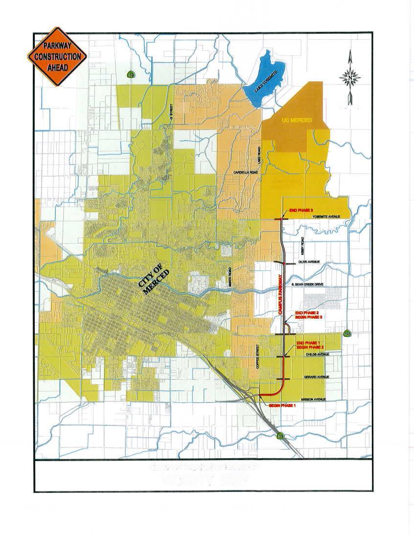
4 TRAFFIC IMPACT ANALYSIS FOR TEMPLO LA HERMOSA CHURCH Merced County, CA INTRODUCTION This report documents KD Anderson & Associates' assessment of traffic impacts associated with developing the Templo La Hermosa Church Project. This analysis is intended to quantify the traffic impacts of the project and address local circulation near the project site within the context of both current and future background conditions. While the proposed project lies within Merced County and will be processed through the County, State Route 140 adjoining the project is under the jurisdiction of Caltrans. Thus, the scope of this study was identified in consultation with Merced County and Caltrans, and standards of significance / evaluation methodologies accepted by these agencies have been employed. Project Description The Templo La Hermosa Church Project is proposed on a site on the north side of State Route 140 between the City of Merced and Planada, as noted in Figure 1. The project site is near the planned northerly extension of Campus Parkway, and the new church will lie within the loop connecting SR 140 and the Campus Parkway crossing over SR 140. As shown in the project site plan (Figure 2), when the crossing is constructed the project will include access at two locations onto the loop (Recovery Road) but will not have direct access to SR 140, as noted in Figure 3. Prior to the completion of Campus Parkway and Recovery Road, the proposed church facility would gain interim access via a private roadway between the proposed project site and Dell Street, an existing minor street located approximately 400 feet east of the project site. Access to the state highway would be from the existing SR 140 / Dell Street intersection. A temporary access easement would remain in use until the Campus Parkway and the Recovery Road segment are completed and permanent access to Recovery Road, Campus Parkway, and SR 140 is granted to the project applicant by Merced County and the California Department of Transportation (Caltrans). Once the County and Caltrans grant access to Recovery Road, Campus Parkway, and SR 140, the temporary access easement and right-of-way to Dell Street will be closed and reclaimed by the owner. Today Templo La Hermosa operates from a building located on Kibby Road north of SR 140. Church representatives indicate that they now have three services on Sunday morning beginning at ten o'clock with the last service beginning at twelve noon. The church normally attracts roughly 220 people to their main service, which is at ten o'clock. With development of the proposed project Templo La Hermosa expects to be able to accommodate up to 400 persons for service at the new site. The church expects to house 220 persons under interim conditions, and hours of operation are not expected to change. Traffic Impact Analysis for Page 1 Templo La Hermosa Church, Merced County (November 14, 2012)
5 Traffic Impact Analysis for Page 2 Templo La Hermosa Church, Merced County (November 14, 2012)
6 Traffic Impact Analysis for Page 3 Templo La Hermosa Church, Merced County (January 31, 2012)
7 Traffic Impact Analysis for Page 4 Templo La Hermosa Church, Merced County (January 31, 2012)
8 EXISTING SETTING The Templo La Hermosa church project site is served by SR 140, which links the church with Merced to the west and Planada to the east. Some church members also reach the site via Kibby Road, a local Merced County road that crosses the BNSF railroad and intersects SR 140 about! mile east of the project site. In the near future, the second phase of the Campus Parkway project will be extended northerly to connect to SR 140. This new road will provide the site with an alternative connection to the south, and a subsequent third phase will extend Campus Parkway north to Yosemite Avenue. The project as presented for review is a moderately sized church located at what may become a more developed urban fringe of the Merced (metro) area (in the next 20 plus years). The church will replace an existing building located on Kibby Road just north of SR 140. SR 140 is an important regional road that is expected to accommodate a relatively large amount of traffic. A substantial amount of industrially zoned land (with available water and sewer service) within the City of Merced urban boundary is located on the south side of SR 140. Study Area Circulation System - Roads State Route 140 is an east-west Principal Arterial that links Interstate 5 near Gustine with the City of Merced before continuing easterly to the central entrance of Yosemite National Park. In the vicinity of the proposed project, SR 140 is a two lane conventional highway with auxiliary turn lanes at major intersections. The California Department of Transportation (Caltrans) provides annual reports of the volume of traffic on the state highway system. Recent counts available from Caltrans report an Annual Average Daily Traffic (AADT ) volume of 7,400 vehicles per day in the area of the project between Santa Fe Avenue and Planada. Campus Parkway is a north-south expressway that will link SR 99 at Mission Avenue with SR 140 and subsequently Yosemite Avenue near UC-Merced. The first phase of this four lane facility has been constructed from SR 99 to its current terminus at Child Avenue. The second phase will extend the expressway from Childs Avenue northerly across the BNSF railroad and SR 140. This phase will terminate at a loop ramp that will intersect SR 140 near the Templo La Hermosa site. Recovery Road. The planned connection linking SR 140 and Campus Parkway is named Recovery Road and will be a four lane facility. Access will be permitted to adjoining properties, including the Templo La Hermosa site. The current plans for Recovery Road include a raised center median in the immediate area of Campus Parkway and SR 140 that would restrict access to right turns only for roughly 200 feet from each major street. Kibby Road is a local north south road that provides access to the industrial / agricultural areas of eastern Merced areas around SR 140. Kibby Road is a two lane road that begins at an intersection on Childs Avenue and continues northerly to an at-grade crossing on the BNSF railroad and an intersection on SR 140 before continuing northerly to Yosemite Avenue. Traffic Impact Analysis for Page 5 Templo La Hermosa Church, Merced County (November 14, 2012)
9 Dell Street is a minor local street that extends north from SR 140 for roughly 400 feet to serve a limited number of rural residences. The width and condition of Dell Street varies along its width. The width ranges from 14 to 20 feet, and the road is poor to fair condition. Dell Street is roughly feet wide at its intersection with SR 140 where the road crosses a culvert located along the north side of the highway. Study Area Circulation System - Intersections The quality of traffic flow is often governed by the operation of key intersections. The following intersections have been identified for evaluation in this study in consultation with Merced County and Caltrans staff. The SR 140 / Kibby Road intersection is an existing intersection controlled by stop signs on the northbound and southbound Kibby Road approaches. Auxiliary left turn lanes exist on the SR 140 approaches, but the Kibby Road approaches are single lanes. The SR 140 / Dell Street intersection is an existing intersection controlled by a stop sign on the southbound Dell Street approach. Dell Street is a single lane approach, and there are no auxiliary turn lanes on SR 140 at this intersection. The planned SR 140 / Recovery Road intersection is a tee intersection that will be controlled by a traffic signal when Phase 2 of the Campus Parkway project is completed. The intersection will include separate right and left turn lanes on the southbound Recovery Road approach, Auxiliary turn lanes will be provided on eastbound SR 140 (left turn) and westbound SR 140 (right turn). The project includes two driveways onto Recovery Road when Phase 2 of the Campus Parkway project is completed. The southern driveway is roughly 200 feet north of SR 140 and this location will be limited to right turns only by a raised median. North of the median, a continuous two way left turn lane will be created along Recovery Road, and this lane will be available at the northern church driveway. Full access is planned at the northern access. Standards of Significance / Policies The following criteria have been established to quantify the level of significance of an adverse effect being evaluated pursuant to CEQA. An impact would be considered significant if the project would: Conflict with an applicable plan, ordinance or policy establishing measures of effectiveness of the circulations system, including but not limited to Merced County roads, state highways and freeways, city streets, pedestrian and bicycle paths, and transit; Conflict with an applicable congestion management program, including but not limited to level of service standards and travel demand measures, or other standards established by the county congestion management agency for designated roads or highways; Traffic Impact Analysis for Page 6 Templo La Hermosa Church, Merced County (November 14, 2012)
10 Result in change to air traffic patterns, including either an increase in traffic levels or a change in locations that results in substantial safety risks; Substantially increase hazards due to a design feature (e.g., sharp curves or dangerous intersections) or incompatible uses (e.g. farm equipment); Result in inadequate emergency access, or Conflict with adopted polices, plans or programs regarding, public transit, bicycle, or pedestrian facilities, or otherwise decrease the performance or safety of such facilities. Significance criteria for unincorporated Merced County, the state freeway system, and other jurisdictions are based upon the applicable standards of each jurisdiction. Unincorporated Merced County. Merced County criteria include: Roadway Segments A project is considered to have a significant effect if it would: result in a roadway operating at an acceptable LOS (LOS C for rural areas and LOS D for urban areas) to deteriorate to an unacceptable LOS (Note: pending new language) Bicycle and Pedestrian Facilities A project is considered to have a significant effect if it would: eliminate or adversely affect an existing bikeway or pedestrian facility in a way that would discourage its use interfere with the implementation of a planned bikeway as shown in the Bicycle Master Plan, or be in conflict with a Pedestrian Master Plan result in unsafe conditions for bicyclists or pedestrians, including unsafe bicycle/pedestrian, bicycle/motor vehicle, or pedestrian/motor vehicle conflict Safety A project is considered to have a significant effect if it would: substantially increase hazards due to a design feature (e.g., sharp curves or dangerous intersections) or incompatible uses (e.g., farm equipment) Transit A significant impact to the transit system occurs when: an adequate and appropriate level of transit services is not available in a timely manner to serve new development Caltrans. Caltrans polices are noted in The Guide for the Preparation of Traffic Impact Studies (California Department of Transportation [Caltrans] 2002) which identifies circumstances under which Caltrans determines that a traffic impact study would be required. The document also details information that is to be included in the study, analysis scenarios, and guidance on acceptable analysis methodologies. In addition to the guidelines, Caltrans prepares Transportation Concept Reports (TCRs) for each of its facilities. A TCR is a long-term planning document that each Caltrans district prepares for every state highway or portion thereof in its jurisdiction. This Traffic Impact Analysis for Page 7 Templo La Hermosa Church, Merced County (November 14, 2012)
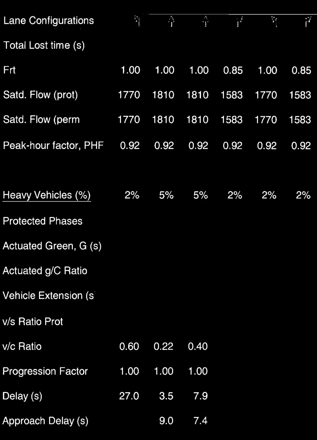
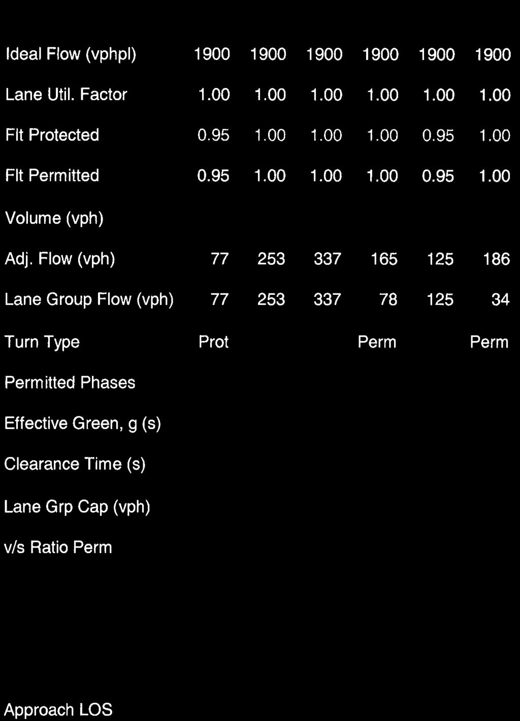
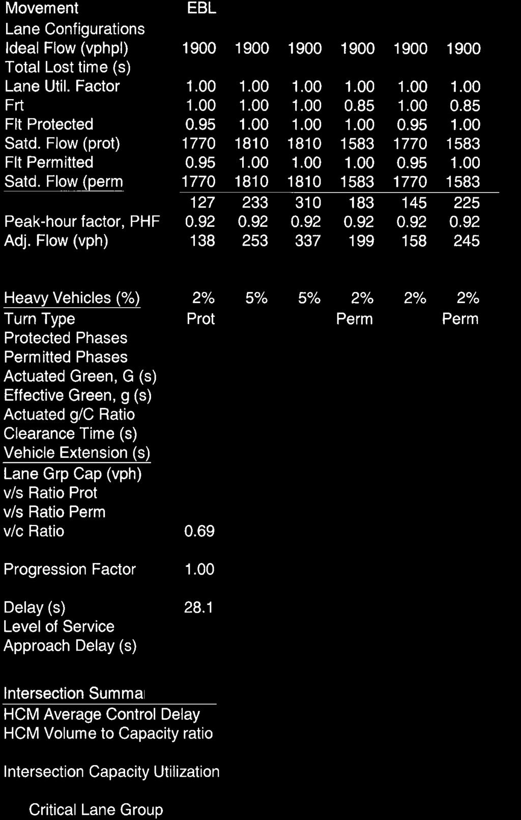
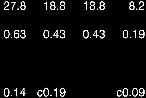
11 document usually represents the first step in Caltrans long-range corridor planning process. The purpose of a TCR is to determine how a highway will be developed and managed so that it delivers the targeted level of service (LOS) and quality of operations that are feasible to attain over a 20-year period. These are indicated in the route concept. In addition to the 20-year route concept level, the TCR includes an ultimate concept, which is the ultimate goal for the route beyond the 20-year planning horizon. Ultimate concepts must be used cautiously, however, because unforeseen changes in land use and other variables make forecasting beyond 20 years difficult. TCR s do not necessarily consider the amount, type and location of development within Merced County that is addressed by the 2030 General Plan. A project is considered to have a significant effect if it would: result in a roadway operating at the RTC Concept Level of Service (i.e., LOS C or LOS D or better, as applicable) to deteriorate to an unacceptable LOS D, E or worse Regional Transportation Plan (RTP). The Merced County 2011 RTP includes this policy. Roadway Segments A project is considered to have a significant effect if it would: result in a roadway operating at LOS D or better to deteriorate to an unacceptable LOS E or worse Level of Service To assess the quality of existing traffic conditions and provide a basis for analyzing project impacts, Levels of Service were calculated at study area intersections and project driveways. "Level of Service" is a qualitative measure of traffic operating conditions whereby a letter grade "A" through "F", corresponding to progressively worsening operating conditions, is assigned to an intersection or roadway segment. The Level of Service policies of Caltrans and Merced County govern this analysis. The Merced County General Plan documents the County s policies for Level of Service in rural and urban areas. The current General Plan notes that LOS C is the minimum standard in rural areas, including the study area for this analysis. The County is currently updating its General Plan, and the update includes a proposed policy that would accept LOS D on major roads in rural areas (i.e., major collectors and above). The minimum Level of Service standards for state highways are noted in the Transportation Concept Report (TCR) prepared for each route. The Concept LOS for this portion of SR 140 is LOS D. Methodology at Signalized Intersections. Various methodologies exist to determine operating Levels of Service at signalized intersections. The available techniques vary with regard to factors such as traffic signal timing, interaction between adjoining signals, etc. The procedures contained in the 2000 Highway Capacity Manual have been used for determining operating Level of Service at both signalized intersections. Traffic Impact Analysis for Page 8 Templo La Hermosa Church, Merced County (November 14, 2012)
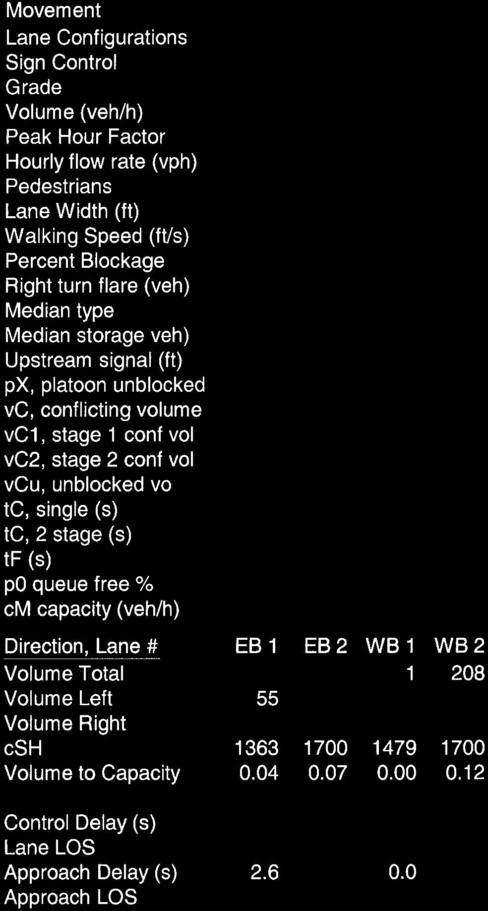
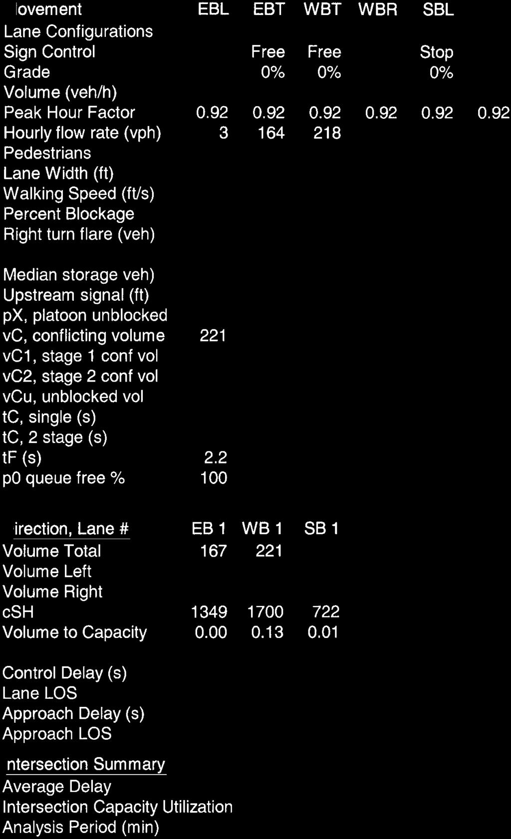
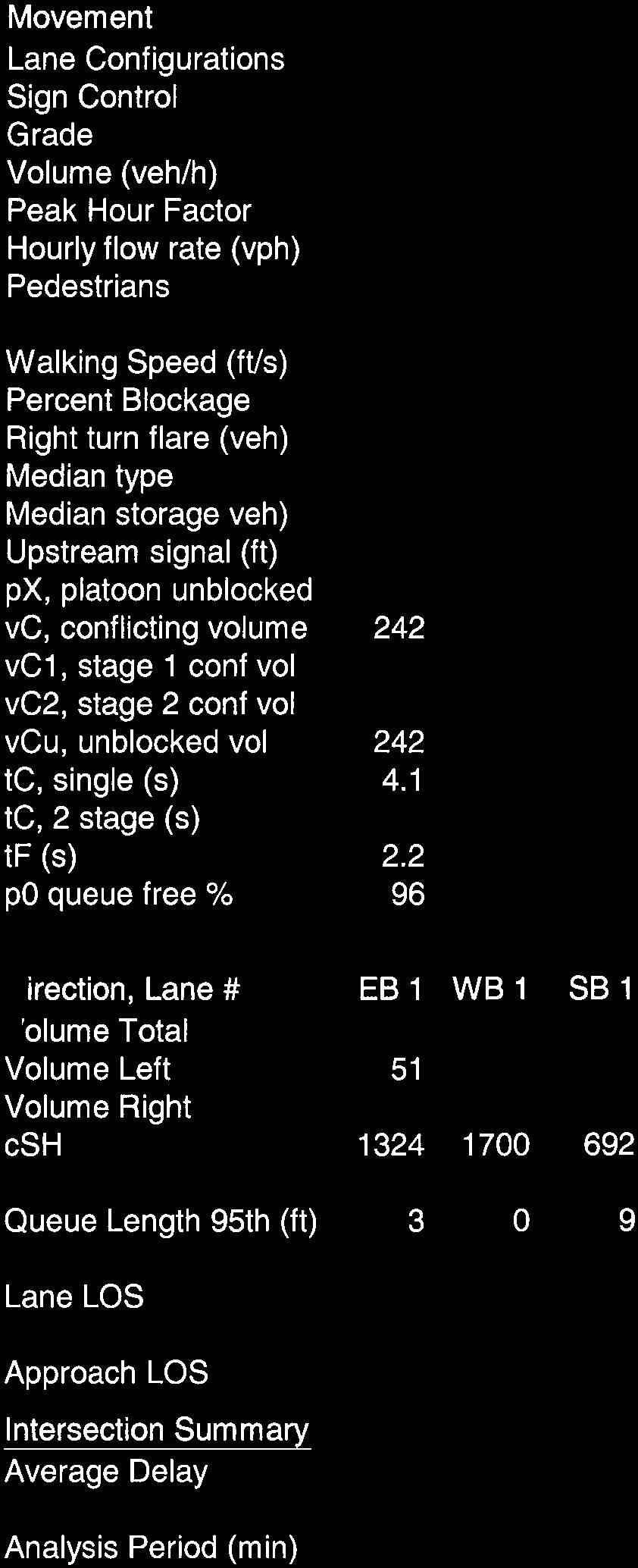
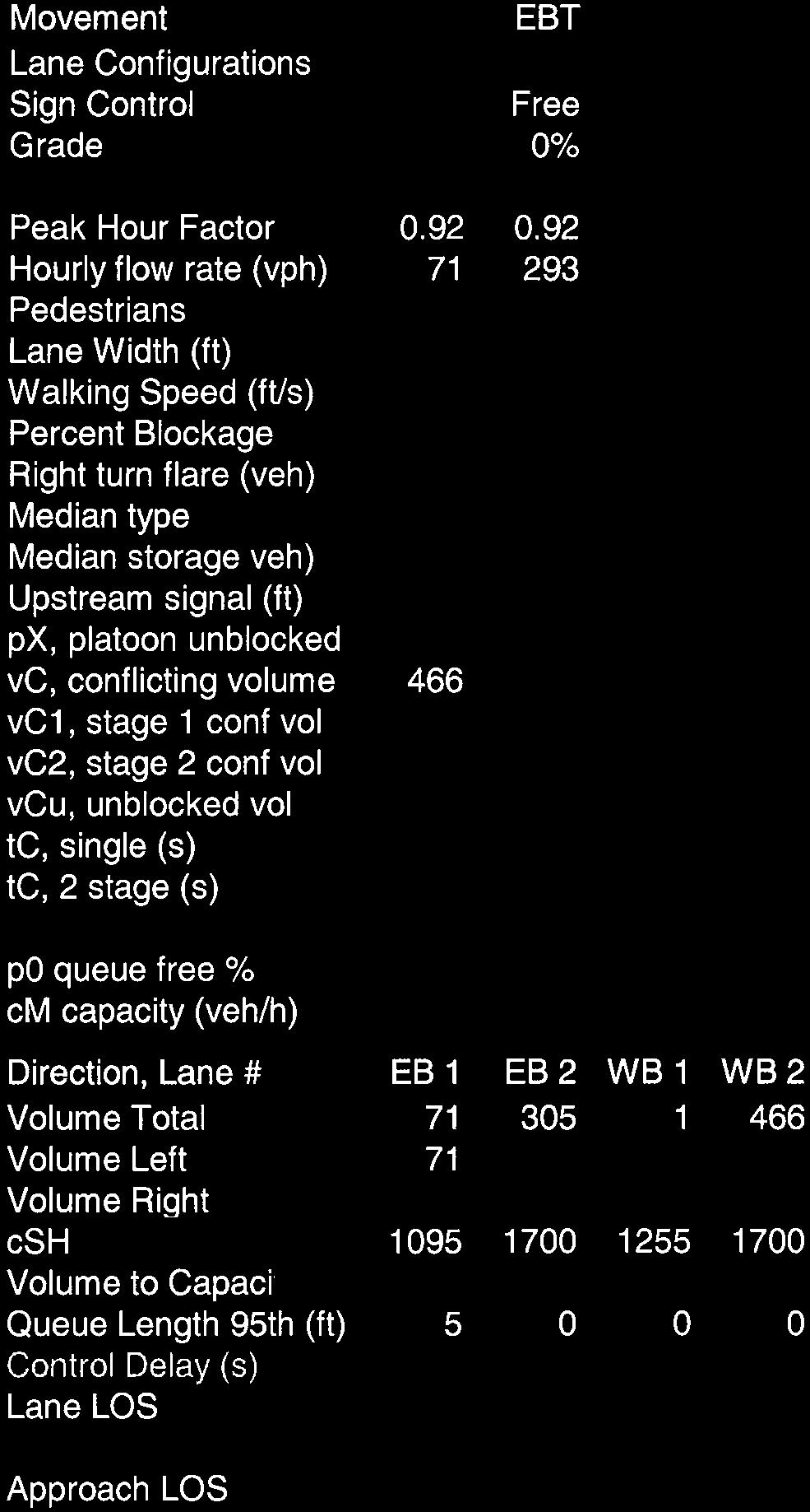
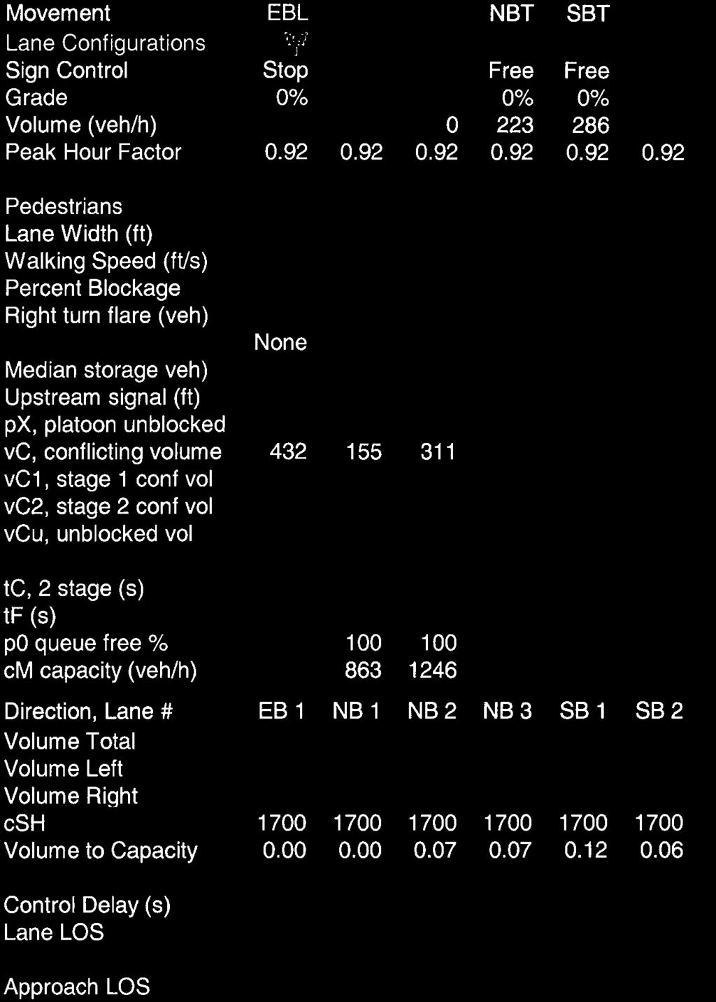
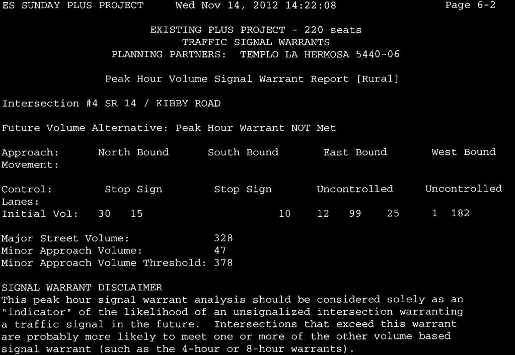
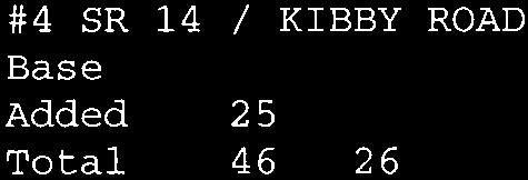
12 Table 1 presents general characteristics associated with each Level of Service grade. Methodology at Unsignalized Intersections. At unsignalized intersections the number of gaps in through traffic, gap acceptance time and corresponding delays for motorists waiting to turn are used for Level of Service analysis. Procedures used for calculating unsignalized intersection Level of Service are as presented the Highway Capacity Manual, 2000 edition. TABLE 1 LEVEL OF SERVICE DEFINITIONS Level of Service Signalized Intersection Unsignalized Intersection Roadway (Daily) "A" Uncongested operations, all queues clear in a single-signal cycle. Ave Delay < 10 seconds per vehicle Little or no delay. Ave Delay < 10 sec/veh Completely free flow. "B" "C" "D" "E" "F" Uncongested operations, all queues clear in a single cycle. Delay > 10 sec/veh and < 20 sec/veh Light congestion, occasional backups on critical approaches. Delay >20 sec/veh and <35 sec/veh Significant congestions of critical approaches but intersection functional. Cars required to wait through more than one cycle during short peaks. No long queues formed. Delay > 35 sec/veh and < 55 sec/veh Severe congestion with some long standing queues on critical approaches. Blockage of intersection may occur if traffic signal does not provide for protected turning movements. Traffic queue may block nearby intersection(s) upstream of critical approach(es). Delay >55 sec and < 80 sec/veh Total breakdown, stop-and-go operation. Delay > 80 sec/veh Sources: 2000 Highway Capacity Manual, Short traffic delays. Delay > 10 sec/veh and < 15 sec/veh Average traffic delays. Delay > 15 sec/veh and < 25 sec/veh Long traffic delays. Delay > 25 sec/veh and < 35 sec/veh Very long traffic delays, failure, extreme congestion. Delay > 35 sec/veh and < 50 sec/veh Intersection often blocked by external causes. Delay > 50 sec/veh Free flow, presence of other vehicles noticeable. Ability to maneuver and select operating speed affected. Unstable flow, speeds and ability to maneuver restricted. At or near capacity, flow quite unstable. Forced flow, breakdown. Existing Traffic Volumes and Intersection Levels of Service Because Templo La Hermosa will continue to have services on Sundays, this analysis addresses traffic conditions occurring during mid-day Sunday. Sunday traffic counts were conducted at the SR 140 / Kibby Road intersection between the hours of 9:00 a.m. and 12:00 p.m. on December 16, The highest one-hour volume observed during this time period occurred from 9:30 to 2:30 a.m. These counts are included in the appendix to this report. Because Dell Street provides access to a limited number of residences, the volume of traffic Traffic Impact Analysis for Page 9 Templo La Hermosa Church, Merced County (November 14, 2012)
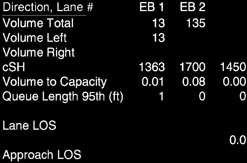
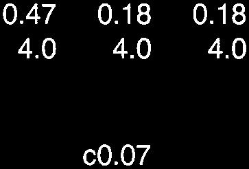
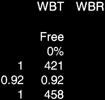
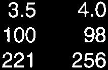
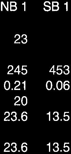
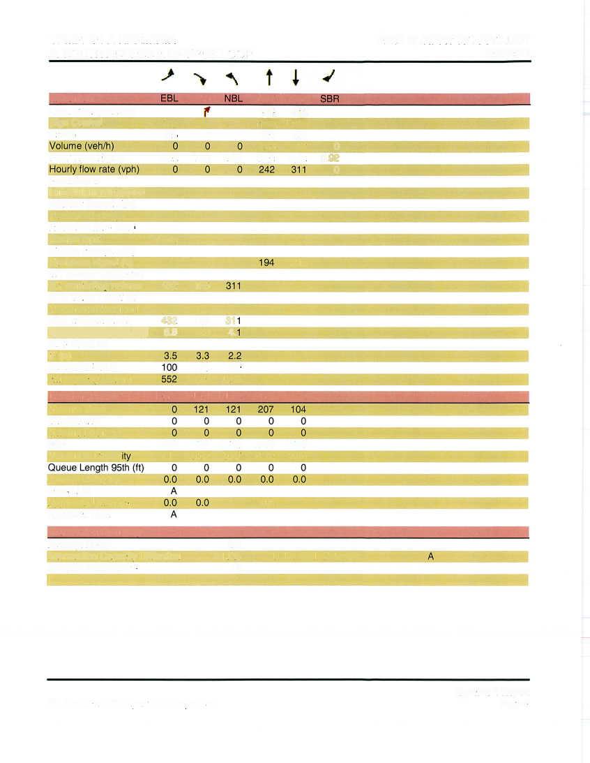
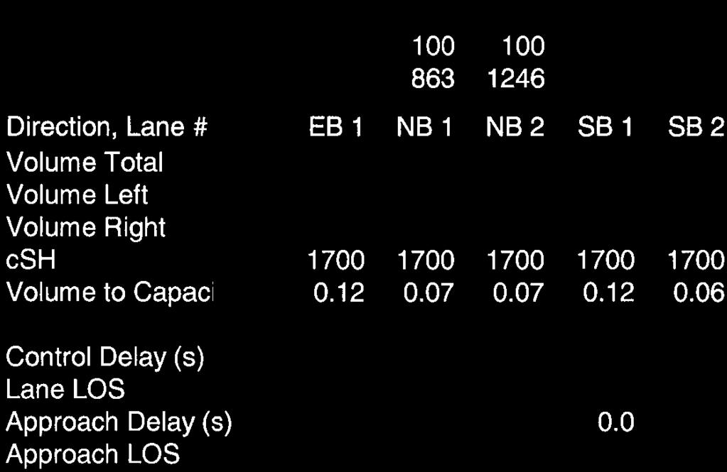
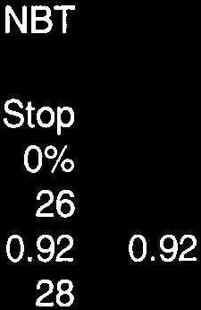
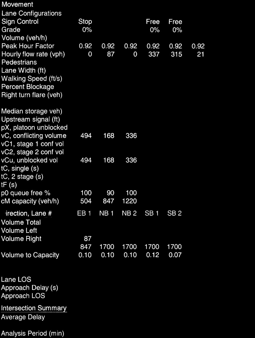
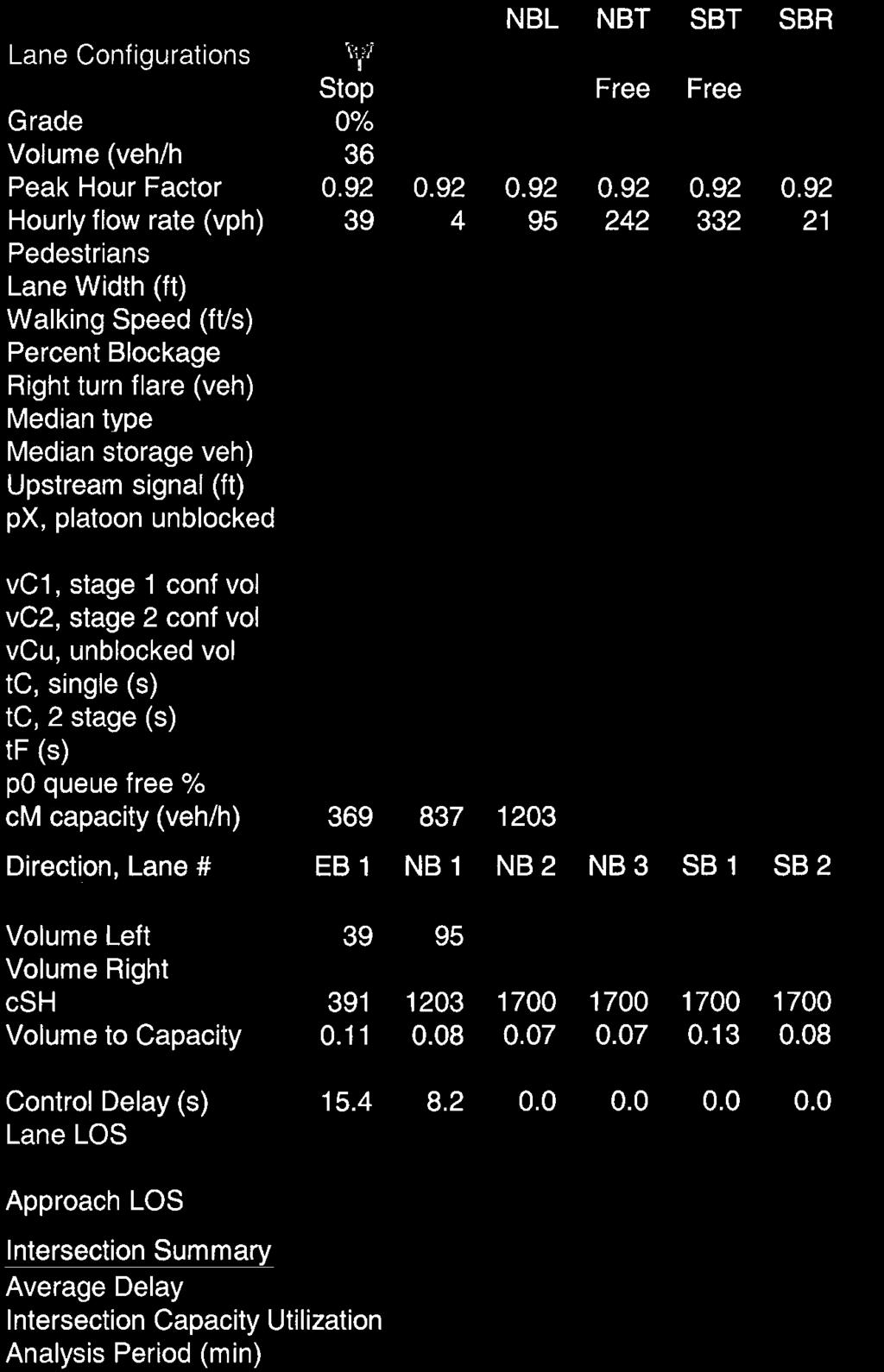
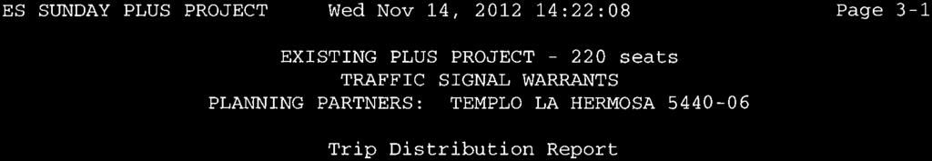
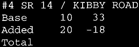
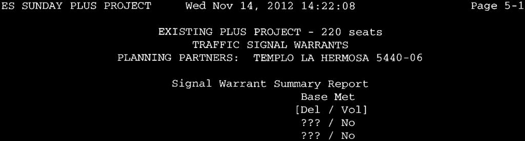
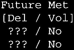
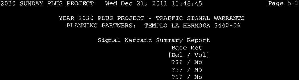
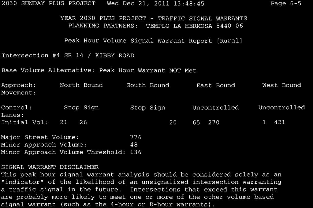
13 using Dell Street was not monitored. This analysis assumes fewer than five inbound and five outbound vehicles would use the road during the Sunday peak hour. Because SR 140 is a regional route providing access to Yosemite National Park, the volume of traffic occurring on Sundays can vary throughout the year. To consider seasonal traffic volume variation, hourly traffic count data was obtained from a location on SR 140 near Santa Fe Avenue, and this data was used to identify the variation in 24 hr volume occurring on Sundays. That data revealed that the typical Sunday volume occurring in winter months (i.e., December, January and February) was 93% of the average Sunday volume monitored over the course of the year. That data also indicated that typical daily volumes in summer months (i.e., June, July and August), were 107% of the annual average for Sundays. Based on direction from Caltrans District 10, the volumes observed in December 2011 were adjusted to represent annual average Sunday conditions. This was accomplished by holding the traffic volumes on Kibby Road constant while increasing through traffic on SR 140. The resulting traffic volumes are presented in Figure 4. Table 2 presents current Sunday morning peak hour Level of Service at the study area intersections. As shown, both the SR 140 / Dell Street intersection and the SR 140 / Kibby Road intersection currently operates with LOS B conditions on the side street approaches. These Levels of Service meet the minimum requirements of both Caltrans and Merced County for minimum operating LOS. In addition, existing traffic volumes do not reach the level that would satisfy peak hour traffic signal warrants under rural thresholds. TABLE 2 EXISTING INTERSECTION LEVEL OF SERVICE Location SR 140 / Dell Street EB left turn SB left+right turn SR 140 / Kibby Road EB left turn WB left turn NB left+thru+right turn SB left+thru+right turn Control Average Delay (seconds/vehicle) SB Stop NB/SB Stop Sunday 9:30 to 10:30 a.m. Existing Level of Service A B A A B B Traffic Signal Warrants Met? No No Traffic Impact Analysis for Page 10 Templo La Hermosa Church, Merced County (November 14, 2012)
14 Current Safety Issues The adequacy of the existing circulation system considers the need for a left turn lane on SR 140 at Dell Street. Guidelines for Left Turn Lane Channelization. Caltrans determines the need for left turn lanes based on quantitative guidelines developed by the American Association of State Highway and Transportation Officials (AASHTO). The AASHTO publication, A Policy on Geometric Design of Highways and Streets, 2004 includes Exhibit 9-75, which is presented in Table 3 below. This exhibit suggests the combination of advancing and opposing traffic volumes and left turn percentage that would justify a left turn lane on a rural highway. Low volume roads or intersections with few turning vehicles do not justify turn lanes, but large numbers of left turns on busy roads can impede through traffic and create a safety problem. As shown in Table 3, the current traffic volumes during the Sunday peak hour do not approach a level that justifies a left turn lane at the SR 140 / Dell Street intersection. TABLE 3 TRAFFIC VOLUMES JUSTIFYING LEFT TURN LANE Opposing Volume (veh/h) % Left Turns Advancing Volume4 (veh/h) 10% 20% Left Turns Left Turns 40-mph operating speed mph operating speed mph operating speed RED values are Existing conditions at SR 140 / Dell Street % Left Turns Source: A policy on Geometric Design of Highway and Streets, AASHTO, Traffic Impact Analysis for Page 11 Templo La Hermosa Church, Merced County (November 14, 2012)
15 Facilities for Alternative Transportation Modes Transit. Merced County Transit provides bus service in the Merced area. Fixed route service (i.e., The Bus) is available on SR 140 between Planada and Merced. However, The Bus does not run on Sundays. Bicycle / Pedestrian Facilities. Today there are no dedicated bicycle or transit facilities in the immediate area of the proposed project, although bicyclists and pedestrians can use the existing paved shoulders on SR 140. Facilities for pedestrians and bicyclists are expected in the future. A mixed use pedestrian / bike path will accompany the Campus Parkway project. The 2008 Bicycle Commuter Plan indicates that bicycle lanes will be created on SR 140 in the future. Traffic Impact Analysis for Page 12 Templo La Hermosa Church, Merced County (November 14, 2012)
16 Traffic Impact Analysis for Page 13 Templo La Hermosa Church, Merced County (November 14, 2012)
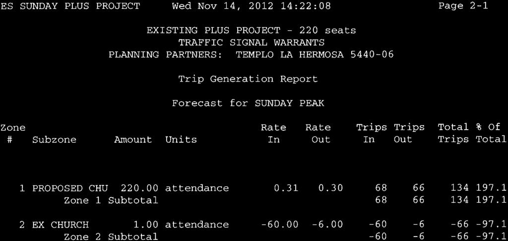
17 PROJECT IMPACTS The proposed project is the relocation and expansion of a church that already serves the southeast Merced Planada area. Today Templo La Hermosa operates from a site on Kibby Road north of SR 140. The church has three services on Sundays, with the main 10:00 a.m. service typically attracting 220 persons. The new project will be larger and could accommodate up to 400 persons for services that are expected under the same schedule. Ultimately, the project site has access via connections to Recovery Road, the planned loop road that will link SR 140 with Phase II of the Campus Parkway. Because the project may precede construction of the Parkway, an interim plan for site access has been developed that would link the project with Dell Street, an existing local street that intersects SR 140 in the area east of the planned Parkway. Project Characteristics Trip Generation. The amount of new traffic associated with development projects is typically forecast using information developed from recognized national sources. The Institute of Transportation Engineers (ITE) publication Trip Generation, 8 th Edition is a source recognized by Merced County and Caltrans, and applicable trip generation rates for the typical Sunday operation of churches are presented in Table 4, along with available weekday rates. TABLE 4 TRIP GENERATION RATES / FORECASTS Land Use Church (ITE) Unit / Quantity Trip Generation Sunday Sunday Peak Hour Weekday P.M. Peak Hour Daily Inbound Outbound Total Inbound Outbound Total Seats % 49% ksf % 50% % 52% 0.55 Templo La Hermosa 220 seats Interim 400 seats Templo La Hermosa 10.6 ksf Weekday p.m. trip generation rates based on ksf because no per seat rate is available The parameter resulting in the greatest number of trips has been used. As shown in Table 4, under Interim conditions the church could generate 407 daily trips with 134 trips in the peak hour. A church with 400 persons in attendance could generate 740 daily trips with 244 trips generated during the peak hour. Traffic Impact Analysis for Page 14 Templo La Hermosa Church, Merced County (November 14, 2012)
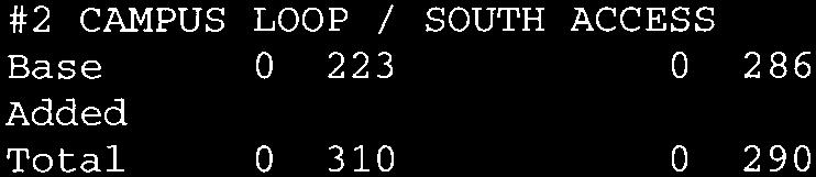
18 Weekday activities at the project site will include typical ancillary activities that accompany a church, but the amount of traffic occurring on a particular weekday could vary. Weekday activities are typically scheduled in the evenings after the peak commute hour or during midday. As a result, the number of trips occurring during the weekday peak commute hour would be very low (i.e., 6 trip ends). As noted, the most appreciable traffic volumes associated with the project will occur on Sundays before and after church services. The amount of regular weekday traffic accompanying this project is very low in comparison to its Sunday forecasts and is so low as to suggest that there is no significant possibility that analysis of weekday conditions would identify additional impacts or yield additional mitigation measures. Therefore, this impact analysis has been limited to peak conditions on the day when services will be held, which in this case is Sunday. Trip Distribution. Having determined the number of trips that are expected to be generated by the project, it is necessary to identify the directional distribution of project-generated traffic. For churches, the location of church attendee residences is the primary indicator of the regional trip distribution. As noted earlier, Templo La Hermosa holds services at the Kibby Road site, and the relative distribution of its members is known. Church representatives report that roughly 70% of their members live west of the site in Merced, with 30% living to the east and south. This distribution was confirmed from the travel patterns identified from review of the turning movement counts made at the SR 140 / Kibby Road intersection. In the long term a portion of the traffic now headed west on SR 140 will be diverted to Campus Parkway. Table 5 presents the regional distribution of project trips under both short term (i.e., before Campus Parkway) and Year 2030 conditions. TABLE 5 REGIONAL TRIP DISTRIBUTION ASSUMPTIONS Percent of Total Direction Origin / Destination Route Short term Year 2030 North Eastern Merced Campus Parkway 0% 15% Kibby Road 2% 2% East Planada SR 140 3% 3% South Planada, South Merced Kibby Road 30% 20% Campus Parkway 0% 15% West Central Merced SR % 45% Total 100% 100% Project Trip Assignment. Figure 5 presents the assignment of project trips under a short term conditions with 220 persons in attendance before Phase II of the Campus Parkway is constructed. Under this condition all site traffic uses the interim easement to Dell Street and travels through the SR 140 / Dell Street intersection. Traffic Impact Analysis for Page 15 Templo La Hermosa Church, Merced County (November 14, 2012)
19 Traffic Impact Analysis for Page 16 Templo La Hermosa Church, Merced County (November 14, 2012)
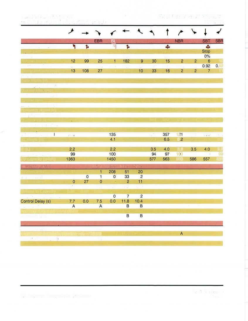
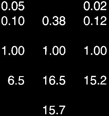
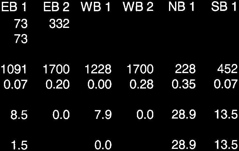
20 Existing Plus Project Traffic Impacts Level of Service. Figure 6 superimposes project trips onto the current background traffic volumes to create three Existing plus Project conditions. Under these conditions a portion of the trips attracted to the project will be made by church members who are already driving to the Kibby Road church. The relocation of these existing trips is reflected in Figure 6, as several movements at the SR 140 / Kibby Road intersection are reduced when the new church is in operation. Under this condition it is assumed that the vacant Templo La Hermosa building on Kibby Road is not immediately occupied by another user. Re-use of the building is assumed, however, under Year 2030 condition. Table 6 compares the Existing and Existing plus Project Levels of Service at study intersections. As shown, the addition of project trips does not appreciably change the operating conditions at the SR 140 / Kibby Road intersection. The Level of Service for motorists waiting to turn onto the state highway on Sunday mornings will remain at LOS B. Similarly, the Level of Service for motorists waiting to turn onto SR 140 from the church s interim access via Dell Street will also be LOS B. As with any church there may be short periods of congestion immediately after the end of services, but the overall flow of traffic to and from the site will be within Merced County and Caltrans minimum standards. Based on the resulting Level of Service, the project s traffic impact is less than significant. TABLE 6 EXISTING PLUS TEMPLO LA HERMOSA PROJECT INTERIM 220 ATTENDEES INTERSECTION LEVEL OF SERVICE Location SR 140 / Dell Street EB left turn SB left+right turn SR 140 / Kibby Road EB left turn WB left turn NB left+thru+right turn SB left+thru+right turn Control Avg Delay (sec/veh) SB Stop NB/SB Stop Existing Conditions Level of Service A B A A B B Sunday 9:30 to 10:30 a.m. Warrants Met? Avg Delay (sec/veh) No No Existing Plus Project Level of Service A B A A B B Warrants Met? No No Traffic Impact Analysis for Page 17 Templo La Hermosa Church, Merced County (November 14, 2012)
21 Traffic Impact Analysis for Page 18 Templo La Hermosa Church, Merced County (November 14, 2012)
22 Safety Impacts. The impacts of the Templo La Hermosa Church have also been evaluated within the context of safety at the Dell Street connection to SR 140. Approach Width. Because Dell Street is relatively narrow near its intersection with SR 140, inbound motorists may have difficulty turning from SR 140 towards the site when outbound traffic is concurrently waiting to turn onto the state highway. This constraint may result in delays for inbound traffic that could interfere with the flow of through traffic on SR 140. However, because the church normally staggers services, inbound and outbound traffic is not likely to occur concurrently. Because the number of vehicles involved is small, this potential conflict does not represent a significant safety impact. Left Turn Lane Channelization. The key issue to be considered is the extent to which project trips justify the construction of an eastbound left turn lane on SR 140 at the Dell Street intersection. Table 7 identifies approaching and opposing traffic volumes with operation of the church. In this case, if 220 persons attend the main church service under interim conditions, the combination of opposing traffic (223 vehicles) and advancing traffic (158 vehicles of which 30% turn left) does not approach the level that justifies a left turn lane. TABLE 7 TRAFFIC VOLUMES JUSTIFYING LEFT TURN LANE Opposing Volume (veh/h) 5% Left Turns Advancing Volume4 (veh/h) 10% 20% Left Turns Left Turns 30% Left Turns 60-mph operating speed BLUE values are Existing plus Project with 220 attendees. Source: A policy on Geometric Design of Highway and Streets, AASHTO, Traffic Impact Analysis for Page 19 Templo La Hermosa Church, Merced County (November 14, 2012)
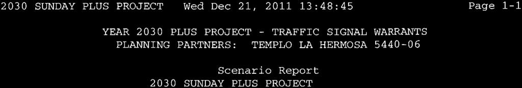
23 CUMULATIVE TRAFFIC IMPACTS The cumulative impact of the Templo La Hermosa Church project has been considered within the context of long term conditions resulting from development under the Merced County General Plan, as well as circulation system improvements planned for eastern Merced. Year 2030 Traffic Conditions Land Use Assumptions. The long term cumulative scenario is based on year 2030 traffic volume forecasts developed for the pending Merced County General Plan Update EIR. These forecasts were made using the MCAG regional travel demand forecasting model and reflect regional assumptions for land use development originally authored by the Sate of California Department of Finance. As noted previously with the development of the proposed project the Templo La Hermosa congregation will relocate from the existing church site on Kibby Road. While re-use of that site in the immediate future is uncertain, it is likely that by the Year 2030 the Kibby Road site will be occupied by a use permitted under current zoning. For this analysis of Sunday impacts, the worst case use of the site would be another church operating under a schedule similar to that maintained by Templo La Hermosa. Circulation System Improvements. Based on direction from Merced County, the following circulation system improvements are expected to be completed by the Year Campus Parkway Phase II and II to Yosemite Avenue 2. SR 140 Santa Fe Avenue Overcrossing (under construction) 3. Signalization of SR 140 / Recovery Road intersection 4. Signalization of Campus Parkway / Recovery Road intersection. Approach. The approach taken to create Year 2030 Sunday peak hour traffic volumes makes use of weekday traffic volume forecasts made for the Merced County GPU EIR. Table 8 identifies the volume of traffic expected on study area roads in the Year As noted, the current daily traffic volume on SR 140 will more than double by the year TABLE 8 YEAR 2030 WEEKDAY TRAFFIC VOLUME FORECASTS Road Location Daily Volume Existing Year 2030 Rate SR 140 Santa Fe Avenue to Campus Parkway 7,400 18, SR 140 Campus Parkway to Kibby Road 7,400 16, Campus Parkway Childs Avenue to SR ,200 - Campus Parkway SR 140 to Yosemite Avenue - 21,400 - Recovery Road SR 140 to Campus Parkway - 12,400 - Traffic Impact Analysis for Page 20 Templo La Hermosa Church, Merced County (November 14, 2012)
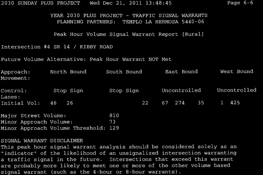
24 Intersection turning movements were identified for the No Project condition by factoring modeled daily turning movement forecasts based on the current ratio of Sunday peak hour traffic to average annual daily weekday traffic. Today the peak hour volume observed on Sunday west of Kibby Road is equal to 4.9% of the 7,400 AADT reported by Caltrans. The current directionality observed for traffic during the Sunday peak hour on SR 140 was assumed to remain (i.e., 57% towards Merced and 43% out of Merced). Lacking any other basis, traffic traveling between Campus Parkway and SR 140 west of the parkway was assumed to be spit 50% inbound and 50% outbound. Resulting Year 2030 No Project traffic volumes for the Sunday peak hour are identified in Figure 7. This figure also identifies the intersection geometry expected at study area intersections with the completion of Campus Parkway As shown in Figure 8, Year 2030 Plus Project traffic was created by superimposing project trips onto the background condition under the distribution assumptions previously identified. These volumes are noted in Table 8. Year 2030 Plus Project Traffic Impacts Level of Service. Year 2030 Levels of Service with and without the proposed project are shown in Table 9. As indicated, the addition of project traffic results in one location where the operating Level of Service may exceeds the County s current LOS C minimum standard. Traffic waiting to turn onto SR 140 from northbound Kibby Road may experience delays that are indicative of LOS D. However, the traffic volumes at the intersection do not reach the level that would satisfy peak hour warrants for signalization, and Caltrans would be unlikely to allow a traffic signal to be installed under these circumstances. LOS D will satisfy the standard for major roads in urban areas under the pending GPU and will meet the LOS D Concept Level of Service identified in the SR 140 TCR. Based on these considerations, the cumulative impact of the Templo La Hermosa Church Project at these locations is not significant under Year 2030 conditions, and no mitigation measures are required. Traffic Impact Analysis for Page 21 Templo La Hermosa Church, Merced County (November 14, 2012)
25 Traffic Impact Analysis for Page 22 Templo La Hermosa Church, Merced County (November 14, 2012)
26 Traffic Impact Analysis for Page 23 Templo La Hermosa Church, Merced County (November 14, 2012)
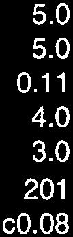
27 Location Recovery Rd/North Access NB left turn EB left+right turn Recovery Rd/South Access EB right turn TABLE 9 CUMULATIVE YEAR 2030 SUNDAY INTERSECTION LEVELS OF SERVICE Control Year 2030 Sunday 9:30 to 10:30 a.m. No Project Conditions Plus Project conditions Warrants Avg Delay LOS LOS Met? (sec/veh)e Avg Delay (sec/veh) EB Stop EB Stop A C Warrants Met? No 9.7 A No SR 140 / Recovery Road Signal 10.1 B n.a B n.a. SR 140 / Kibby Road EB left turn WB left turn NB left+thru+right turn SB left+thru+right turn NB/SB Stop A A C B No A A D B No Safety: Queue Length. Under Year 2030 conditions the primary safety issue relates to the interaction between site access and traffic queuing at the SR 140 / Recovery Road intersection. A safety issue could arise if the queue of waiting traffic extended back to the southern driveway, which is roughly 200 feet from SR 140. As noted in Table 10, during the Sunday peak period, the 95 th percentile queue on the southbound Recovery Road approach to SR 140 is only expected to reach 71 feet north of the highway. Thus, access to the site should not be affected by queuing, and this impact is not significant. TABLE 10 YEAR 2030 INTERSECTION QUEUE LENGTHS Location Direction Lane SR 140 / Recovery Road SB Peak Hour Volume (vph) 95 th Percentile Queue (feet) Left turn Right turn EB Left turn Traffic Impact Analysis for Page 24 Templo La Hermosa Church, Merced County (November 14, 2012)
28 TECHNICAL APPENDIX FOR TEMPLO LA HERMOSA CHURCH TRAFFIC IMPACT ANALYSIS Prepared For: PLANNI NG PARTNERS 7281 Lone Pine Drive, Suite D-203 Sloughhouse, CA Prepared By: KD Anderson & Associates, Inc Taylor Road, Suite G Loomis, CA (916) November 14, 2012 Job No Templo La Hermosa Church rpt!"#$%&'"(#()'$*+$,)$--"%*


29
30


31


32
33

34

35


36

37

38


39

40

41
42
43
44
45

46
47
48
49
50
51
52
53
54
55
56

57
58
59

60
61
62
63
64
Abrams Associates. Transportation Impact Analysis. City of Rocklin. Prepared for: David Mohlenbrok City of Rocklin 4081 Alvis Court Rocklin, CA 95677
 Transportation Impact Analysis Sierra College Boulevard Commercial Project City of Rocklin Prepared for: David Mohlenbrok City of Rocklin 081 Alvis Court Rocklin, CA 95677 Prepared by: 1875 Olympic Boulevard,
Traffic Circulation Study for Neighborhood Southwest of Mockingbird Lane and Airline Road, Highland Park, Texas
 ARIZONA TEXAS NEW MEXICO OKLAHOMA February 13, 2015 Mr. Meran Dadgostar P.E., R.S. Town of Highland Park 4700 Drexel Dr. Highland Park, Texas 75205 Re: Traffic Circulation Study for Neighborhood Southwest
TRAFFIC IMPACT ANALYSIS
 TRAFFIC IMPACT ANALYSIS FOR THE CHAMPAIGN UNIT#4 SCHOOL DISTRICT PROPOSED HIGH SCHOOL (SPALDING PARK SITE) IN THE CITY OF CHAMPAIGN Final Report Champaign Urbana Urbanized Area Transportation Study 6/24/2014
METHODOLOGY. Signalized Intersection Average Control Delay (sec/veh)
") Chapter 5 Traffic Analysis 5.1 SUMMARY US /West 6 th Street assumes a unique role in the Lawrence Douglas County transportation system. This principal arterial street currently conveys commuter traffic
Chapter 5 Traffic Analysis 5.1 SUMMARY US /West 6 th Street assumes a unique role in the Lawrence Douglas County transportation system. This principal arterial street currently conveys commuter traffic
TRANSPORTATION ANALYSIS REPORT US Route 6 Huron, Erie County, Ohio
 TRANSPORTATION ANALYSIS REPORT US Route 6 Huron, Erie County, Ohio December 12, 2012 Prepared for: The City of Huron 417 Main Huron, OH 44839 Providing Practical Experience Technical Excellence and Client
3.9 - Transportation and Traffic
 Transportation and Traffic 3.9 - Transportation and Traffic This section describes the potential transportation and traffic effects of project implementation on the project site and its surrounding area.
INDUSTRIAL BUILDING 3009 HAWTHORNE ROAD CITY OF OTTAWA TRANSPORTATION OVERVIEW REVISED. Prepared for: Canada Inc.
 INDUSTRIAL BUILDING 3009 HAWTHORNE ROAD CITY OF OTTAWA TRANSPORTATION OVERVIEW REVISED Prepared for: 7849648 Canada Inc. Octiober 1, 2015 114-598 Overview_2.doc D. J. Halpenny & Associates Ltd. Consulting
5.3 TRAFFIC, CIRCULATION AND PARKING
 5.3 TRAFFIC, CIRCULATION AND PARKING This section is based upon the Downtown Lancaster Specific Plan Traffic Impact Analysis (April 2, 2008) and the Downtown Lancaster Specific Plan Parking Analysis (May
Complete Street Analysis of a Road Diet: Orange Grove Boulevard, Pasadena, CA
 Complete Street Analysis of a Road Diet: Orange Grove Boulevard, Pasadena, CA Aaron Elias, Bill Cisco Abstract As part of evaluating the feasibility of a road diet on Orange Grove Boulevard in Pasadena,
List of Attachments. Location Map... Site Plan... City of Lake Elsinore Circulation Element... City of Lake Elsinore Roadway Cross-Sections...
 List of Attachments Exhibits Location Map... Site Plan... City of Lake Elsinore Circulation Element... City of Lake Elsinore Roadway Cross-Sections... Existing Lane Geometry and Traffic Controls... Existing
4.15 TRANSPORTATION AND TRAFFIC
 4.15 TRANSPORTATION AND TRAFFIC The purpose of the Transportation and Traffic section is to describe existing and future traffic circulation and parking patterns, and to evaluate the impact of the proposed
THIS PAGE LEFT BLANK INTENTIONALLY
 GA SR 25 Spur at Canal Road Transportation Impact Analysis PREPARED FOR GLYNN COUNTY, GEORGIA 1725 Reynolds Street, Suite 300 Brunswick, Georgia 31520 PREPARED BY 217 Arrowhead Boulevard Suite 26 Jonesboro,
Henderson Avenue Mixed-Use Development
 Zoning Case: Z145-3 Traffic Impact Analysis Henderson Avenue Mixed-Use Development Dallas, TX October 26 th, 216 Kimley-Horn and Associates, Inc. Dallas, Texas Project #644827 Registered Firm F-928 Traffic
Waterford Lakes Small Area Study
 Waterford Lakes Small Area Study Existing Traffic Conditions PREPARED FOR: ORANGE COUNTY PUBLIC WORKS DEPARTMENT TRAFFIC ENGINEERING DIVISION ORLANDO, FLORIDA PREPARED WITH: INWOOD CONSULTING ENGINEERS
Chapter 4 Traffic Analysis
 Chapter 4 Traffic Analysis PURPOSE The traffic analysis component of the K-68 Corridor Management Plan incorporates information on the existing transportation network, such as traffic volumes and intersection
Traffic Study North Shore School District 112
 Traffic Study North Shore School District 112 Proposed Expansion of Northwood Junior High School Prepared By: May 1, 2015 1. Introduction Kenig, Lindgren, O Hara, Aboona, Inc. (KLOA, Inc.) has been retained
Traffic Impact Analysis Walton Acres at Riverwood Athletic Club Clayton, NC
 Traffic Impact Analysis Walton Acres at Riverwood Athletic Club Clayton, NC 1. TABLE OF CONTENTS INTRODUCTION...1 1.1. Site Location and Study Area...1 1.2. Proposed Land Use and Site Access...2 1.3.
TABLE TRAFFIC ANALYSIS SCENARIOS
 4.11 TRANSPORTATION The potential traffic impacts of the proposed project are evaluated in the Buena Park Beach/Orangethorpe Mixed Use Project Traffic Analysis (Traffic Analysis) by Austin-Foust Associates
Glenn Avenue Corridor Traffic Operational Evaluation
 Glenn Avenue Corridor Traffic Operational Evaluation PREPARED FOR: THE CITY OF AUBURN PREPARED BY: DECEMBER 2007 Glenn Avenue Corridor Study--Auburn, Alabama TABLE OF CONTENTS Introduction... 1 Background
Mission Street Medical Office Development
 reet Medical Office Development Traffic Impact Analysis Prepared for: Palo Alto Medical Foundation February 23, 2012 Hexagon Office: 7888 Wren Avenue, Suite B121 Gilroy, CA 95020 Hexagon Job Number: 11RD11
Traffic Impact Study. Westlake Elementary School Westlake, Ohio. TMS Engineers, Inc. June 5, 2017
 TMS Engineers, Inc. Traffic Impact Study Westlake Elementary School Westlake, Ohio June 5, 2017 Prepared for: Westlake City Schools - Board of Education 27200 Hilliard Boulevard Westlake, OH 44145 TRAFFIC
OFFICE/RETAIL DEVELOPMENT 1625 BANK STREET OTTAWA, ONTARIO TRANSPORTATION BRIEF. Prepared for: Canada Inc.
 OFFICE/RETAIL DEVELOPMENT 1625 BANK STREET OTTAWA, ONTARIO TRANSPORTATION BRIEF Prepared for: 9402209 Canada Inc. December 15, 2015 115-625 Report_2.doc D. J. Halpenny & Associates Ltd. Consulting Transportation
REVIEW OF LOCAL TRAFFIC FLOW / LONG RANGE PLANNING SOLUTIONS STUDY
 ITEM Town of Atherton TRANSPORTATION COMMITTEE STAFF REPORT TO: FROM: MEMBERS OF THE COMMITTEE ROBERT OVADIA, PUBLIC WORKS DIRECTOR DATE: FEBRUARY 12, 2019 SUBJECT: REVIEW OF LOCAL TRAFFIC FLOW / LONG
MEDICAL/OFFICE BUILDING 1637 BANK STREET OTTAWA, ONTARIO TRANSPORTATION OVERVIEW. Prepared for:
 MEDICAL/OFFICE BUILDING 1637 BANK STREET OTTAWA, ONTARIO TRANSPORTATION OVERVIEW Prepared for: 2434984 Ontario Inc. 13-5510 Canotek Road Ottawa, Ontario K1J 9J5 June 4, 2015 115-613 Report_2.doc D. J.
Magnolia Place. Traffic Impact Analysis. Prepared for: City of San Mateo. Prepared by: Hexagon Transportation Consultants, Inc.
 Magnolia Place Traffic Impact Analysis Prepared for: City of San Mateo Prepared by: Hexagon Transportation Consultants, Inc. Updated January 4, 2010 Table of Contents 1. Introduction...1 2. Existing Conditions...6
OTTAWA TRAIN YARDS PHASE 3 DEVELOPMENT CITY OF OTTAWA TRANSPORTATION IMPACT STUDY. Prepared for:
 OTTAWA TRAIN YARDS PHASE 3 DEVELOPMENT CITY OF OTTAWA TRANSPORTATION IMPACT STUDY Prepared for: The Ottawa Train Yards Inc. 223 Colonnade Road South, Suite 212 Nepean, Ontario K2E 7K3 January 17, 2012
INDUSTRIAL BUILDING 1660 COMSTOCK ROAD CITY OF OTTAWA TRANSPORTATION OVERVIEW. Prepared for:
 INDUSTRIAL BUILDING 1660 COMSTOCK ROAD CITY OF OTTAWA TRANSPORTATION OVERVIEW Prepared for: Simluc Contractors Limited 2550 Blackwell Street, Ottawa K1B 5R1 October 18, 2013 113-584 Overview_1.doc D. J.
D.13 Transportation and Traffic
 This section addresses transportation and traffic issues and impacts related to the Proposed Project. Section D.13.1 provides a description of the affected environment for the Proposed Project. Applicable
TRAFFIC ASSESSMENT River Edge Colorado
 TRAFFIC ASSESSMENT River Edge Colorado Submitted by: Fehr & Peers 621 17th Street, Ste. 231 Denver, CO 8293 (33) 296-43 December, 21 App. M-2 Traffic Assessment River Edge Colorado December 21 TABLE OF
MEETING FACILITY 2901 GIBFORD DRIVE CITY OF OTTAWA TRANSPORTATION BRIEF. Prepared for: Holiday Inn Express 2881 Gibford Drive Ottawa, ON K1V 2L9
 MEETING FACILITY 2901 GIBFORD DRIVE CITY OF OTTAWA TRANSPORTATION BRIEF Prepared for: Holiday Inn Express 2881 Gibford Drive Ottawa, ON K1V 2L9 December 18, 2012 112-566 Brief_1.doc D. J. Halpenny & Associates
FORM A PASCO COUNTY ACCESS CONNECTION PERMIT APPLICATION
 FORM 901.3.A PASCO COUNTY ACCESS CONNECTION PERMIT APPLICATION The following information is required from all applicants directly or indirectly accessing any collector or arterial road or as otherwise
Walmart (Store # ) 60 th Street North and Marion Road Sioux Falls, South Dakota
 60 th Street North and Marion Road Sioux Falls, South Dakota") Walmart (Store #4865-00) 60 th Street North and Marion Road Sioux Falls, South Dakota Prepared for: Wal-Mart Stores, Inc. Bentonville, Arkansas Prepared by: Kimley-Horn and Associates, Inc. ã2013 Kimley-Horn
Walmart (Store #4865-00) 60 th Street North and Marion Road Sioux Falls, South Dakota Prepared for: Wal-Mart Stores, Inc. Bentonville, Arkansas Prepared by: Kimley-Horn and Associates, Inc. ã2013 Kimley-Horn
Donahue Drive Corridor Traffic Operational Evaluation
 Donahue Drive Corridor Traffic Operational Evaluation PREPARED FOR: THE CITY OF AUBURN PREPARED BY: JANUARY 2007 Donahue Drive Corridor Study--Auburn, Alabama TABLE OF CONTENTS Introduction... 1 Background
QUICKIE C STORE AND GAS BAR 1780 HERON ROAD OTTAWA, ONTARIO TRANSPORTATION BRIEF. Prepared for:
 QUICKIE C STORE AND GAS BAR 1780 HERON ROAD OTTAWA, ONTARIO TRANSPORTATION BRIEF Prepared for: Quickie Convenience Stores Larny Holdings Ltd. c/o PBC Group April 15, 2015 115-615 Report_1.doc D. J. Halpenny
Traffic Impact Study WestBranch Residential Development Davidson, NC March 2016
 Traffic Impact Study WestBranch Residential Development Davidson, NC March 216 TRAFFIC IMPACT STUDY FOR THE WestBranch Residential Development LOCATED IN DAVIDSON, NC Prepared For: Lennar Carolinas, LLC
TRAFFIC IMPACT STUDY COMPREHENSIVE UPDATE TOWN OF THOMPSON S STATION, TENNESSEE PREPARED FOR: THE TOWN OF THOMPSON S STATION
 TRAFFIC IMPACT STUDY COMPREHENSIVE UPDATE TOWN OF THOMPSON S STATION, TENNESSEE PREPARED FOR: THE TOWN OF THOMPSON S STATION Transportation Consultants, LLC 1101 17 TH AVENUE SOUTH NASHVILLE, TN 37212
APPENDIX F SUPPLEMENTAL TRAFFIC DATA
 APPENDIX F SUPPLEMENTAL TRAFFIC DATA Environmental and Planning Consultants 440 Park Avenue South 7th Floor New York, NY 10016 tel: 212 696-0670 fax: 212 213-3191 www.akrf.com Draft Memorandum To: Michael
Lincoln Avenue Road Diet Trial
 Lincoln Avenue Road Diet Trial Data Collection Report June 1, 2015 Department of Transportation Table of Contents I. Introduction...... 3 II. Data Collection Methodology & Results...... 5 A. Traffic Volume
4. ENVIRONMENTAL IMPACT ANALYSIS 9. TRANSPORTATION AND TRAFFIC
 4. ENVIRONMENTAL IMPACT ANALYSIS 9. TRANSPORTATION AND TRAFFIC 4.9.1 INTRODUCTION The following section addresses the Proposed Project s impact on transportation and traffic based on the Traffic Study
TRAFFIC IMPACT STUDY And A TRAFFIC SIGNAL WARRANT ANALYSIS FOR A SENIOR LIVING AND APARTMENT DEVELOPMENT
 TRAFFIC IMPACT STUDY And A TRAFFIC SIGNAL WARRANT ANALYSIS FOR A SENIOR LIVING AND APARTMENT DEVELOPMENT DEERFIELD TOWNSHIP, WARREN COUNTY, OHIO Nantucket Circle and Montgomery Road () Prepared for: ODLE
TABLE OF CONTENTS TABLE OF CONTENTS... I APPENDICES... III LIST OF EXHIBITS... V LIST OF TABLES... VII LIST OF ABBREVIATED TERMS...
 TABLE OF CONTENTS TABLE OF CONTENTS... I APPENDICES... III LIST OF EXHIBITS... V LIST OF TABLES... VII LIST OF ABBREVIATED TERMS... IX 1 INTRODUCTION... 1 1.1 Project Overview... 1 1.2 Analysis Scenarios...
Focused Traffic Analysis for the 200 Nellen Avenue Project
 March 13, 2017 Mr. Phil Boyle Town of Corte Madera 300 Tamalpais Drive Corte Madera, CA 94976-0159 Focused Traffic Analysis for the 200 Nellen Avenue Project Dear Mr. Boyle; W-Trans has completed a focused
4.12 TRANSPORTATION Executive Summary. Setting
 4.12 TRANSPORTATION 4.12.1 Executive Summary This section is based on the Multimodal Transportation Impact Study (TIS; 2016) prepared by Omni-Means, Ltd. to evaluate projected transportation impact conditions
Clackamas County Comprehensive Plan
 ROADWAYS The County s road system permits the movement of goods and people between communities and regions, using any of a variety of modes of travel. Roads provide access to virtually all property. They
5.16 TRAFFIC AND CIRCULATION
 5.16 TRAFFIC AND CIRCULATION This section is based upon the Tierra Robles Traffic Impact Study (May 2015) and Supplemental Traffic Impact Analysis (August 2017) prepared by Omni-Means Engineering Solutions,
Truck Climbing Lane Traffic Justification Report
 ROUTE 7 (HARRY BYRD HIGHWAY) WESTBOUND FROM WEST MARKET STREET TO ROUTE 9 (CHARLES TOWN PIKE) Truck Climbing Lane Traffic Justification Report Project No. 6007-053-133, P 101 Ι UPC No. 58599 Prepared by:
DUNBOW ROAD FUNCTIONAL PLANNING
 DUNBOW ROAD FUNCTIONAL PLANNING Final Report August 3, 216 #31, 316 5th Avenue NE Calgary, AB T2A 6K4 Phone: 43.273.91 Fax: 43.273.344 wattconsultinggroup.com Dunbow Road Functional Planning Final Report
MEMORANDUM. Charlotte Fleetwood, Transportation Planner
 MEMORANDUM Date: Updated August 22, 2017 To: Organization: Charlotte Fleetwood, Transportation Planner Boston Transportation Department From: Jason DeGray, P.E., PTOE, Regional Director of Engineering
SECTION 1 - TRAFFIC PLANNING
 SECTION 1 - TRAFFIC PLANNING 1.1 TRAFFIC OPERATIONS 1.1.1 Roadway Functional Classification The Multnomah County Comprehensive Framework Plan s Policy 34: Trafficways and the Functional Classification
Chapter 16: Traffic and Parking A. INTRODUCTION
 Chapter 6: Traffic and Parking A. ITRODUCTIO This chapter examines the potential traffic and parking impacts of the proposed Fresh Kills Park roads. The analysis of transit and pedestrians is presented
Traffic Impact Analysis Chatham County Grocery Chatham County, NC
 Chatham County Grocery Chatham County, NC TABLE OF CONTENTS 1. INTRODUCTION... 1 1.1. Location and Study Area... 1 1.2. Proposed Land Use and Access... 2 1.3. Adjacent Land Uses... 2 1.4. Existing ways...
4.10 TRANSPORTATION AND CIRCULATION
 4.10 TRANSPORTATION AND CIRCULATION PURPOSE The section discusses the potential impacts to traffic and circulation as a result of the implementation of the proposed Via Princessa East Extension, which
Freeway System Considerations
 Session 11 Jack Broz, PE, HR Green May 5-7, 2010 Freeway System Considerations Mainline Transit: Shoulder Operations, BRT, Stations HOV, HOT, UPA Interchanges Exit Ramps Entrance Ramps Bridges Local Crossings
URBAN QUARRY HEADQUARTERS 2717 STEVENAGE DRIVE CITY OF OTTAWA TRANSPORTATION OVERVIEW. Prepared for: Urban Quarry 4123 Belgreen Drive, Ottawa K1G 3N2
 URBAN QUARRY HEADQUARTERS 2717 STEVENAGE DRIVE CITY OF OTTAWA TRANSPORTATION OVERVIEW Prepared for: Urban Quarry 4123 Belgreen Drive, Ottawa K1G 3N2 February 27, 2014 113-584 Overview_1.doc D. J. Halpenny
Harrah s Station Square Casino
 Transportation Analysis Harrah s Station Square Casino Pittsburgh, Pennsylvania Submitted To: City of Pittsburgh and Pennsylvania Gaming Control Board Prepared By: DKS Associates GAI Consultants December
FAIRFIELD INN & SUITES HOTEL 135 THAD JOHNSON PRIVATE OTTAWA TRANSPORTATION BRIEF. Prepared for:
 FAIRFIELD INN & SUITES HOTEL 135 THAD JOHNSON PRIVATE OTTAWA TRANSPORTATION BRIEF Prepared for: Bona Building & Management Co. Ltd. Place Vanier, 333 North River Road Vanier, Ontario K1L 8B9 August 12,
Shockoe Bottom Preliminary Traffic and Parking Analysis
 Shockoe Bottom Preliminary Traffic and Parking Analysis Richmond, Virginia August 14, 2013 Prepared For City of Richmond Department of Public Works Prepared By 1001 Boulders Pkwy Suite 300, Richmond, VA
Figure 1: Vicinity Map of the Study Area
 ARIZONA TEXAS NEW MEXICO OKLAHOMA May 5, 2016 Mr. Anthony Beach, P.E. BSP Engineers 4800 Lakewood Drive, Suite 4 Waco, Texas 76710 Re: Intersection and Access Analysis along Business 190 in Copperas Cove
HENDERSON DEVELOPMENT 213, 217, 221, 221 ½, 223 HENDERSON AVENUE and 65 TEMPLETON STREET OTTAWA, ONTARIO TRANSPORTATION OVERVIEW.
 HENDERSON DEVELOPMENT 213, 217, 221, 221 ½, 223 HENDERSON AVENUE and 65 TEMPLETON STREET OTTAWA, ONTARIO TRANSPORTATION OVERVIEW Prepared for: 2294170 Ontario Inc. February 2, 2017 117-652 Report_1.doc
Traffic Impact Study. Roderick Place Columbia Pike Thompson s Station, TN. Transportation Group, LLC Traffic Engineering and Planning
 F i s c h b a c h Transportation Group, LLC Traffic Engineering and Planning Traffic Impact Study Roderick Place Columbia Pike Thompson s Station, TN Prepared March 2016 Ms. Gillian L. Fischbach, P.E.,
2. Existing Conditions
 2. Existing Conditions The existing traffic and parking conditions on the site and the surrounding area were reviewed based on the study methodology in Section 1.2. 2.1 Existing Land Use The portion of
FRONT RANGE CROSSINGS TRAFFIC IMPACT STUDY
 FRONT RANGE CROSSINGS TRAFFIC IMPACT STUDY Prepared for: City of Thornton And Colorado Department of Transportation Prepared by: 11 Blake Street, Suite 2 Denver, Colorado 822 Contact: Brian Bern, PE, PTOE
Project Report. South Kirkwood Road Traffic Study. Meadows Place, TX October 9, 2015
 Meadows Place, TX October 9, 2015 Contents 1 Introduction... 1 2 Data Collection... 1 3 Existing Roadway Network... 2 4 Traffic Volume Development... 2 5 Warrant Analysis... 3 6 Traffic Control Alternative
HILTON GARDEN INN HOTEL HOTEL EXPANSION 2400 ALERT ROAD, OTTAWA TRANSPORTATION BRIEF. Prepared for:
 HILTON GARDEN INN HOTEL HOTEL EXPANSION 2400 ALERT ROAD, OTTAWA TRANSPORTATION BRIEF Prepared for: Bona Building & Management Co. Ltd. Place Vanier, 333 North River Road Vanier, Ontario K1L 8B9 October
REDEVELOPMENT TRAFFIC IMPACT STUDY
 REDEVELOPMENT TRAFFIC IMPACT STUDY For Wendy s Parker, Colorado January 215 Prepared for: Sterling Design Associates, LLC 29 W. Littleton Boulevard #3 Littleton, Colorado 812 Prepared by: 1233 Airport
TRANSPORTATION IMPACT STUDY PROPOSED RIVERFRONT 47 MIXED USE DEVELOPMENT
 November 2016 TRANSPORTATION IMPACT STUDY PROPOSED RIVERFRONT 47 MIXED USE DEVELOPMENT & Aspinwall Borough, Sharpsburg Borough & O Hara Township, Allegheny County, Pennsylvania Prepared for: Riverfront
DRAFT. Corridor study. Honeysuckle Road. October Prepared for the City of Dothan, AL. Prepared by Gresham, Smith and Partners
 DRAFT Corridor study Honeysuckle Road October 2017 Prepared for the City of Dothan, AL Prepared by TABLE OF CONTENTS SECTION I... 1 STUDY SUMMARY... 1 INTRODUCTION... 1 CONCLUSIONS... 5 SECTION II... 7
Troutbeck Farm Development
 Troutbeck Farm Development Willistown Township, Chester County PA For Submission To: Willistown Township Last Revised: October, 4 TPD# INLM.A. 5 E. High Street Suite 65 Pottstown, PA 9464 6.36.3 TPD@TrafficPD.com
CITY OF SASKATOON COUNCIL POLICY
 ORIGIN/AUTHORITY Clause 1, Report No. 1-1980 and Clause 4, Report No. 22-1990 of the Works and Utilities Committee; Clause 6, Report No. 17-2004 of the Planning and Operations Committee; and Clause D5,
7.0 FREEWAYS CONGESTION HOT SPOT PROBLEM & IMPROVEMENT PROJECT ANALYSIS & DEFINITION
 7.0 FREEWAYS CONGESTION HOT SPOT PROBLEM & IMPROVEMENT PROJECT ANALYSIS & DEFINITION 7.1 INTRODUCTION & METHODOLOGY FEASIBILITY REPORT Congestion hot spot problem locations have been assessed using the
MoPac South: Impact on Cesar Chavez Street and the Downtown Network
 MoPac South: Impact on Cesar Chavez Street and the Downtown Network Prepared by: The University of Texas at Austin Center for Transportation Research Prepared for: Central Texas Regional Mobility Authority
VIVA RETIREMENT COMMUNITIES OAKVILLE TRAFFIC IMPACT STUDY
 VIVA RETIREMENT COMMUNITIES OAKVILLE TRAFFIC IMPACT STUDY VIVA RETIREMENT COMMUNITIES OAKVILLE TRAFFIC IMPACT STUDY DECEMBER 2012 READ, VOORHEES & ASSOCIATES TORONTO, ONTARIO Read, Voorhees & Associates
Evaluation of M-99 (Broad Street) Road Diet and Intersection Operational Investigation
 Road Diet and Intersection Operational Investigation") Evaluation of M-99 (Broad Street) Road Diet and Intersection Operational Investigation City of Hillsdale, Hillsdale County, Michigan June 16, 2016 Final Report Prepared for City of Hillsdale 97 North Broad
Evaluation of M-99 (Broad Street) Road Diet and Intersection Operational Investigation City of Hillsdale, Hillsdale County, Michigan June 16, 2016 Final Report Prepared for City of Hillsdale 97 North Broad
Issue Paper on Transportation and Circulation
 Issue Paper on Transportation and Circulation General Plan Update Prepared by: Rincon Consultants, Inc. 1530 Monterey Street, Suite D San Luis Obispo, California 93401 July 2008 Table of Contents Introduction...
NEW YORK CENTRAL PARK SUBDIVISION BLAIS STREET/ST-PIERRE STREET EMBRUN, ONTARIO TRAFFIC IMPACT STUDY. Prepared for:
 NEW YORK CENTRAL PARK SUBDIVISION BLAIS STREET/ST-PIERRE STREET EMBRUN, ONTARIO TRAFFIC IMPACT STUDY Prepared for: Solidex Holdings Limited & Investissement Maurice Lemieux Investments Attn: Mr. Anthony
9 Leeming Drive Redevelopment Ottawa, ON Transportation Brief. Prepared By: Stantec Consulting Ltd.
 9 Leeming Drive Redevelopment Ottawa, ON Transportation Brief Prepared By: Stantec Consulting Ltd. TIA GUIDELINES CHECKLIST Report Context Municipal Address Comment: Section 1.1 Location relative to major
TRAFFIC SIGNAL WARRANT STUDY
 TRAFFIC SIGNAL WARRANT STUDY 5 th STREET & ENCHANTED PINES DRIVE JANUARY 2013 TRAFFIC OPERATIONS ENGINEERING SERVICES/PUBLIC WORKS DEPARTMENT TABLE OF CONTENTS INTERSECTION LOCATION MAP ii INTRODUCTION
RM 620 FEASIBILITY STUDY
 RM 620 FEASIBILITY STUDY Sections 5 & 6 December 7, 2015 STUDY PROCESS Study Purpose and Goals The RM 620 Feasibility Study was launched by the Texas Department of Transportation (TxDOT) to analyze transportation
3.16 TRANSPORTATION, CIRCULATION, AND PARKING Regulatory Setting Environmental Setting ROADWAY SYSTEM
 3.16 TRANSPORTATION, CIRCULATION, AND PARKING This section assesses the potential for implementation of the Orchard Park Redevelopment component of the 2018 LRDP to result in impacts related to transportation,
3.0 PROJECT DESCRIPTION
 The following section of the Draft EIR contains a description of the proposed Elk Grove Boulevard/SR 99 Interchange Modification project, consistent with the requirements of CEQA Guidelines Section 15124.
Northbound San Jose Avenue & I-280 Off-Ramp Road Diet Pilot Project
 Project Overview Fed by a two-lane Interstate-280 (I-280) off-ramp, high vehicular volumes and speeds are longstanding issues along San Jose Avenue. Residents in the surrounding neighborhoods have expressed
1609 E. FRANKLIN STREET HOTEL TRAFFIC IMPACT STUDY EXECUTIVE SUMMARY
 1609 E. FRANKLIN STREET HOTEL TRAFFIC IMPACT STUDY EXECUTIVE SUMMARY Prepared for: The Town of Chapel Hill Public Works Department Traffic Engineering Division Prepared by: HNTB North Carolina, PC 343
4.10 TRAFFIC AND CIRCULATION
 4.10 TRAFFIC AND CIRCULATION The following section is based on a traffic and circulation study prepared by Fehr & Peers, Inc. (November 2003; refer to Appendix F for technical calculations). The effects
EAST AND SOUTH STREET CITY OF ANAHEIM, CALIFORNIA
 T R A F F I C I M P A C T A N A LY S I S EAST AND SOUTH STREET CITY OF ANAHEIM, CALIFORNIA April 217 T R A F F I C I M P A C T A N A LY S I S EAST AND SOUTH STREET CITY OF ANAHEIM, CALIFORNIA Submitted
Appendix C. NORTH METRO STATION AREA TRAFFIC IMPACT STATEMENT 88th Avenue Station
 Appendix C NORTH METRO STATION AREA TRAFFIC IMPACT STATEMENT 88th Avenue Station Prepared for: Regional Transportation Department and URS Corporation as part of the North Metro EIS David Evans and Associates,
Gateway Transportation Study
 Gateway Transportation Study Amherst, Massachusetts SUBMITTED TO University of Massachusetts Amherst Town of Amherst SUBMITTED BY Vanasse Hangen Brustlin, Inc. Watertown, Massachusetts March 213 Back of
Figure 1: East West Connector Alignment Alternatives Concept Drawing
 Page 2 of 9 Figure 1: East West Connector Alignment Alternatives Concept Drawing The Montebello Drive extension will run north south and connect Wilsonville Road to the Boones Ferry Road to Brown Road
Capital Region Council of Governments
 March 23, 2018 Capital Region Council of Governments PROJECT CONCEPT REPORT Realignment of Swamp and Northfield Road s approaches to Route 44 (Boston Turnpike) Town of Coventry SUMMARY: The Town of Coventry
The current document is revised based on the comments received on:
 General Overview 1 Introduction Over the last several years, the Waterford Lakes area has experienced increased congestion due to a substantial increase in residential and commercial development. The current
FINAL DESIGN TRAFFIC TECHNICAL MEMORANDUM
 FINAL DESIGN TRAFFIC TECHNICAL MEMORANDUM July 2014 FINAL (SR 43) Project Development and Environment Study From State Road 60 (Adamo Drive) to I-4 (SR 400) Hillsborough County, Florida Work Program Item
Blair/Williamson Intersection Expressed Needs
 Blair/Williamson Intersection Expressed Needs NORTH Blair Street is a barrier for pedestrians and bicycles Relocate Capitol City Trail crossing from Blair Street and John Nolen Drive intersection to Williamson
Subject: Solberg Avenue / I-229 Grade Separation: Traffic Analysis
 MEMORANDUM Transportation Bill Troe, AICP Jason Carbee, AICP 12120 Shamrock Plaza Suite 300 Omaha, NE 68154 (402) 334-8181 (402) 334-1984 (Fax) To: Project File Date: Subject: Solberg Avenue / I-229 Grade
4.11 TRANSPORTATION 4.11 TRANSPORTATION Environmental Setting Intersection, Roadway, and Freeway Evaluation Methodology
 4.11 TRANSPORTATION This section describes the road transportation system in the vicinity of the proposed Project and the potential impacts to this system from the proposed Project. The analysis in this
Traffic Study of Fuller Street, Cady Street, West Street and West Avenue. Final Report
 Traffic Study of Fuller Street, Cady Street, West Street and West Avenue Final Report July 2005 Prepared for: Town of Ludlow Prepared by: Pioneer Valley Planning Commission 26 Central Street West Springfield,
MEMORANDUM. To: 1.0 PURPOSE
 MEMORANDUM To: Scott Holland, Elements Architecture From: Brian Grover, Dudek Date: July 16, 2014 1.0 PURPOSE In response to the November 4, 2013 request (RE: Incomplete Application Southern California
Grant Avenue Streetscape
 REPORT TYPE GOES HERE Grant Avenue Streetscape PREPARED FOR City of Manassas 9027 Center Street Manassas, VA 20110 PREPARED BY 8300 Boone Boulevard Suite 700 Vienna, Virginia 22182 571.389.8121 July 31,
Design of Turn Lane Guidelines
 Design of Turn Lane Guidelines CTS Transportation Research Conference May 24, 2012 Howard Preston, PE Minnesota Department of Transportation Research Services Office of Policy Analysis, Research & Innovation
Highway 49, Highway 351 and Highway 91 Improvements Feasibility Study Craighead County
 Highway 49, Highway 351 and Highway 91 Improvements Feasibility Study Craighead County Executive Summary March 2015 Highway 49, Highway 351 and Highway 91 Improvements Feasibility Study Craighead County
5858 N COLLEGE, LLC N College Avenue Traffic Impact Study
 5858 N COLLEGE, LLC nue Traffic Impact Study August 22, 2016 Contents Traffic Impact Study Page Preparer Qualifications... 1 Introduction... 2 Existing Roadway Conditions... 5 Existing Traffic Conditions...
Traffic Impact Statement
 Traffic Impact Statement Mixed Use Development, US 41 and Old Trail Drive aka Tide-Starbucks 4900 9 th Street North General Development Site Plan (GDSP) Collier County, FL 10/6/2015 Prepared for: Prepared