CROSS MEDIAN - ROAD SAFETY AUDIT
|
|
|
- Hilary Marsh
- 5 years ago
- Views:
Transcription


1 CROSS MEDIAN - ROAD SAFETY AUDIT Route 140 New Bedford/Freetown/Lakeville November 20, 2009 Prepared For: MassDOT Highway Division Prepared By: BETA Group, Inc.
2 Table of Contents Introduction...1 RSA Process...3 Background...6 Audit Observations...8 Potential Safety Enhancements...10 Recommendations...14 Summary of Road Safety Audit...17 List of Appendices Appendix A. Appendix B. Appendix C. Appendix D. RSA Meeting Agenda RSA Prompt List RSA Audit Team Contact List Detailed Crash Data List of Figures Figure 1. Locus Map... 2 List of Tables Table 1. Participating Audit Team Members... 3 Table 2. Frequency Rating... 4 Table 3. Severity Rating... 5 Table 4. Crash Risk Assessment... 5 Table 5. Summary of Factors that Potentially Affect the Risk of Safety Related Events... 8 Table 6. Criteria For Barrier Selection Table 7. Comparison Costs Table 8. Estimated Time Frame and Costs Breakdown Table 9. Potential Safety Enhancement Summary... 18
3 Introduction The Federal Highway Administration defines a Road Safety Audit (RSA) as the formal safety examination of an existing or future road or intersection by an independent, multidisciplinary team. The purpose of an RSA is to identify potential safety issues and possible opportunities for safety improvements considering all roadway users. The Highway Division of the Massachusetts Department of Transportation (MassDOT) has embraced the RSA program as a low cost opportunity to make significant safety improvements at any number of stages, ranging from project development to existing operation. The RSA program in Massachusetts was implemented in accordance with the Commonwealth s role as a Lead State in preventing lane departure crashes. The MassDOT Highway Division conducted a study of lane departure crashes in 2006, using data from This study found that as crash severity increases, so does the percentage of crashes that are lane departures. This trend has continued in subsequent years. Lane departure crashes account for 18% of all crashes in the Commonwealth. However, nearly one quarter of all Massachusetts crashes involving injury are lane departure crashes and over 46% of all fatal crashes in Massachusetts are lane departure crashes. Additionally, Massachusetts has recently experienced a spate of cross-median crashes (whereby a vehicle crosses the median and ends up in an opposing lane or strikes another vehicle head-on). This type of lane departure crash has the potential for catastrophic outcomes. In 2007, the MassDOT Highway Division began an RSA program to study roadways in which fatal and incapacitating injury cross-median crashes have occurred. As a result of these RSAs, the need for median treatments at each of the locations will be prioritized. A cross-median RSA was conducted for the section of Route 140 from just south of County Road (Exit 9) to just south of Kings Highway (Exit 4). The study section, shown in Figure 1, is approximately nine miles long. The study area is the portion of Route 140 with little existing median barrier. The purpose of this RSA was to identify current conditions of the study area that could affect safety, and to develop both short and long-term solutions to address the safety issues. Recommendations contained in this report are a summary of the recommendations of the RSA team and do not necessarily reflect the official views of MassDOT. Page 1
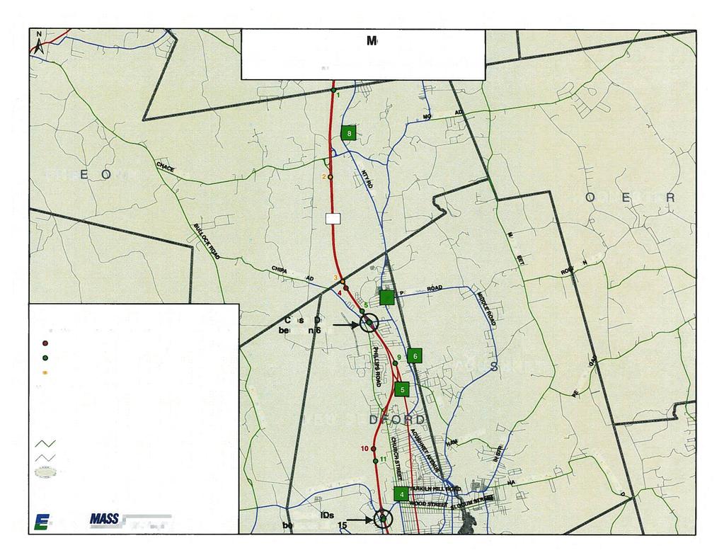
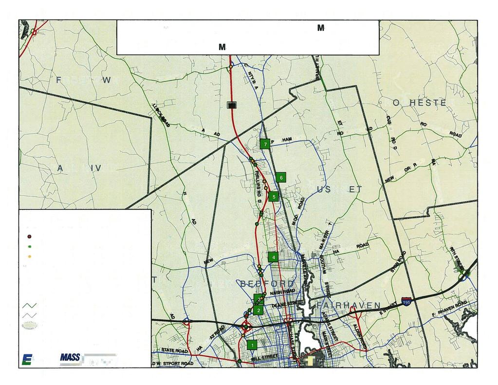
4 CUSHMAN ROAD ³ HOWLAND ROAD LAKEVILLE COUNTY ROAD LAKESIDE AVENUE BEDFORD STREET MIDDLEBOROUGH SLAB BRIDGE ROAD MIDDLEBORO ROAD BRALEY HILL ROAD ROCHESTER FREETOWN CHACE ROAD COUNTY ROAD PROJECT LOCATION 140 MAIN STREET CHIPAWAY ROAD PECKHAM ROAD ROBINSON ROAD BRALEY ROAD FALL RIVER NEW BEDFORD ACUSHNET PERRY HILL ROAD FAUNCE CORNER ROAD NEW PLAINVILLE ROAD ASHLEY BOULEVARD KINGS HIGHWAY BELLEVILLE AVENUE DARTMOUTH 18 ALDEN ROAD 195 HATHAWAY ROAD SHAWMUT AVENUE MAIN STREET ADAMS STREET 195 FAIRHAVEN STATE ROAD 0 4,000 8,000 Feet tu 6 TUCKER ROAD SLOCUM ROAD MT PLEASANT STREET PURCHASE STREET UNION STREET GREEN STREET ROCKDALE AVENUE 315 Norwood Park South Norwood, MA BETA@BETA-inc.com Route 140 CROSS MEDIAN ROAD SAFETY AUDIT LAKEVILLE/FREETOWN/NEW BEDFORD Figure 1 Location Map
5 RSA Process Road Safety Audits are a formal safety performance examination on existing or future roadways by an independent audit team. During the audit, the RSA team works to identify opportunities for improving the safety of the roadway and to recommend specific improvements intended to reduce cross-median crashes and improve the overall safety along the roadway. A Cross Median Road Safety Audit for Route 140 from south of County Road (Exit 9) to Kings Highway (Exit 4) was held on October 28, 2009 at the MassDOT Highway Division District 5 office. As indicated in Table 1, the audit team consisted of representatives from Federal, State and Regional agencies and included a cross-section of engineering, planning, and emergency response expertise. Table 1. Participating Audit Team Members Audit Team Member Bonnie Polin Lisa Schletzbaum Jim Hadfield Jackie Schmidt Tim White Erica Grygorcewicz Agency/Affiliation MassDOT Highway Division Safety Section MassDOT Highway Division Safety Section SRPEDD SRPEDD Federal Highway Administration MassDOT Highway Division Highway Design Bill Travers MassDOT Highway Division District 5 Robert Gregory MassDOT Highway Division District 5 Daniel Mulkern Kenneth Hudson Greg Lucas John Mirabito Mass. State Police Mass. State Police BETA Group BETA Group At the meeting, MassDOT provided a brief overview of the RSA purpose and the audit process, followed by a review of the roadway characteristics and a brief summary of geometry, traffic volume and crash data presented to the audit participants. The audit participants then viewed a video record of the corridor in each direction. During and following the video, audit participants noted potential safety issues along the corridor that may contribute to cross-median crashes, followed by a discussion of possible solutions to mitigate or prevent similar crashes in the future. Key items noted by audit participants included the following: The narrow left shoulder provides little room for recovery of a vehicle. The elevation of the northbound roadway is higher than the southbound roadway. The subsequent median slope is less likely to contain an errant northbound vehicle, which may lead to more northbound cross-median crashes. The crash summary included in the Appendix supports this theory. The curvature of the roadway in several locations may also be a factor in conjunction with the grade separation. Page 3
6 State police enforcement is limited due to limited funding for staff, which may lead to increased speeds along the corridor. There are drainage issues in the vicinity of Exit 6 southbound that lead to ponding on the roadway. The northbound off-ramp at Kings Highway (Exit 4) backs up onto the highway at peak hours due to capacity problems along Kings Highway. The northbound off-ramp at Braley Road (Exit 7) has a longer than typical deceleration lane, which should be delineated by dotted lane markings. Driver fatigue may be enhanced by the relative darkness of the roadway corridor. Deer crossings are common along Route 140. Issues identified by audit participants were evaluated using the guidelines of the Federal Highway Administration (FHWA). The relative seriousness and potential risk relative to crash frequency and severity were determined. These guidelines as outlined by FHWA are shown in Tables 2 and 3. Table 2. Frequency Rating Estimated Exposure Probability High Medium High Medium Low High Low Medium Low High High Medium Medium High Low Medium Low Low Expected Crash Frequency (Per RSA Item) Frequency Rating 5 or more crashes per year Frequent 1 to 4 crashes per year Occasional Less than 1 crash, but more than 1 crash every 5 years Less than 1 crash every 5 years Infrequent Rare Page 4
7 Table 3. Severity Rating Typical Crashes Expected (Per RSA Item) High-speed crashes; head on and rollover crashes Moderate-speed crashes; fixed object or off-road crashes Crashes involving medium to low speeds; lane changing or sideswipe crashes Crashes involving low to medium speeds; typical of rear-end or sideswipe crashes Expected Crash Severity Probable fatality or incapacitating injury Moderate to severe injury Minor to moderate injury Property damage only or minor injury Severity Rating Extreme High Moderate Low The relative risk of a particular audit item is rated by taking into account both frequency and severity. The risk ratings are shown in Table 4. These ratings were used to evaluate each safety issue identified by the audit team. Table 4. Crash Risk Assessment Frequency Rating Severity Rating Low Moderate High Extreme Frequent C D E F Occasional B C D E Infrequent A B C D Rare A A B C Page 5
8 Background A review of available background information was supplemented with field reconnaissance, a video record of the corridor, and a basic evaluation of the existing conditions along the Route 140 corridor. The portion of Route 140 included in the audit extends from just south of County Road (Exit 9) in Lakeville to south of Kings Highway (Exit 6) in New Bedford, a total length of approximately nine miles. The specific focus of the cross-median RSA was the area with little existing median barrier. The audit included both the northbound and southbound roadways. Route 140 is a freeway from its intersection with Route 24 in Taunton to its terminus at Route 6 in New Bedford, a total length of 19 miles. This freeway section serves as the only freeway connection to the city of New Bedford from points north. A MassDOT permanent counting station located on Route 140 in Freetown north of the New Bedford city line recorded 30,600 vehicles per day (vpd) in A review of historical data at this counting station shows that traffic volumes have decreased slightly over the past five years. A field audit was conducted in advance of the RSA meeting to document existing conditions and to create a video recording of the corridor. The RSA Prompt List developed for cross-median RSA s was used as a guideline. The Prompt List is included in the Appendix. The following existing conditions were noted during the field audit: The study area has two lanes in each direction, with a narrow left shoulder and a 10 foot right shoulder. Pavement is generally in good condition. Rumble strips exist in both the left and right shoulder. Location of right shoulder rumble strips vary between the left edge and the center of the shoulder. Acceleration and deceleration lanes appear to be of adequate length, although markings could be improved for guidance. The median width varies from approximately 80 feet at the northern end of the study area to 40 feet from Ashley Blvd (Exit 6) southward. The median is generally a depressed median, graded downward towards a center grass swale. Grades in the median are steeper in the area between Chace Road (Exit 8) and County Road (Exit 9). The median is wooded in the vicinity of Ashley Boulevard (Exit 6). A grade separation exists south of County Road (Exit 9), with the elevation of the northbound roadway being higher than the southbound roadway. Signage is in good condition. Guide signs appear to have been replaced within the last few years and provide adequate advance warning for all interchanges. Page 6

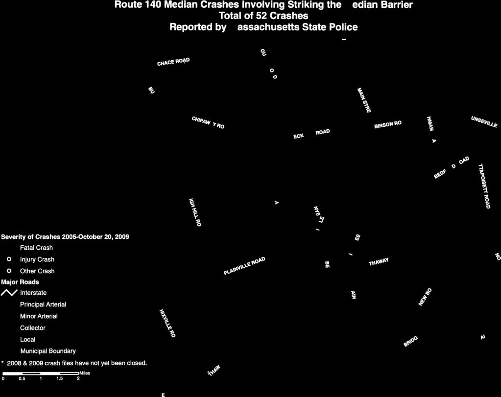
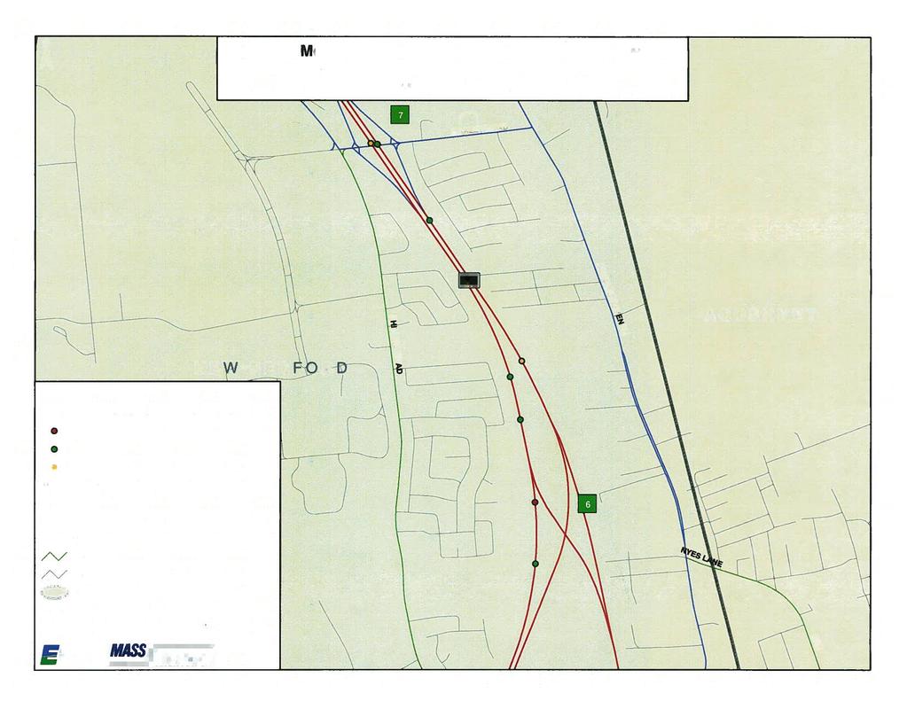
9 The roadway is not lighted. Roadway and lane delineation is enhanced by in-pavement reflectors along the center lane line and yellow delineator posts along the median, although some delineator posts are damaged or missing. Route 140 Northbound South of County Road (Exit 9) Crash data was provided by the MassDOT Highway Division and are included in the Appendix. Crash data were compiled from January 2005 to October 2009, and includes all crashes reported by Massachusetts State Police, with narrative, involving a cross-median crash. The data show 16 crossmedian crashes over the period, or approximately 3.4 cross-median crashes per year. Twelve crashes (75%) resulted in personal injuries or fatalities. There were two fatalities as a result of cross-median crashes. Nine crashes occurred under dawn, dusk or dark conditions. Two of the 16 crashes were the result of wet, snowy or icy road conditions. Eleven crashes (69%) occurred in the northbound direction. There were 127 median crashes reported by Massachusetts State Police over the same time period. The crash summary included in the Appendix details the reason for running off the road and the contributing cause of the crash. It is generally acknowledged that drivers may leave the roadway as the result of one of the following four reasons: Driver Error Collision Avoidance Page 7
10 Roadway Condition Vehicle Component Failure There was no single reason that stood out amongst the contributing causes identified for cross-median crashes on Route 140. High speeds or aggressive driving was cited in three of the 16 crashes. In addition to the 16 cross-median crashes and 127 median crashes, the data show nine crashes involving tree strikes in the median and 52 crashes involving a vehicle striking the median barrier. As expected, the nine crashes involving tree strikes are clustered around Ashley Avenue (Exit 6), where the median is wooded. The 52 crashes involving a vehicle striking the median barrier are clustered at interchanges along the entire corridor and then also along the roadway south of Kings Highway (Exit 4) where there is continuous guardrail in the median. There were 46 deer related crashes reported that involved a vehicle entering the median. Audit Observations Following a brief introduction to the RSA process and a summary of traffic volume and crash information, the audit participants were asked to discuss issues that may affect safety and contribute to median and cross-median crashes along Route 140 in Lakeville, Freetown and New Bedford. Safety issues identified by audit participants are summarized in the following table, and have been assigned a risk rating based on the criteria outlined in Table 4. Table 5. Summary of Factors that Potentially Affect the Risk of Safety Related Events Open, crossable median Narrow left shoulder Factor or Issue Grade separation between northbound and southbound roadways Speeding and driver behavior, limited enforcement Drainage issues near Exit 6 southbound Queuing on Exit 4 northbound off-ramp Markings for deceleration lane at Braley Road (Exit 7) northbound offramp Dark, unlit roadway Deer crossings Risk Rating E E E D D C D E E Further discussion of each factor that potentially affects safety is as follows: Open, crossable median This risk factor was assigned a risk rating of E. The 16 reported crossmedian crashes vary in cause and severity, but could all potentially be prevented or reduced in severity with a safety improvement that mitigates this issue. Page 8
11 Narrow left shoulder Both the northbound and southbound roadways feature a narrow left (inside) shoulder. The 2006 Project and Development Design Guide states that 4 foot left side shoulders should be provided for a freeway cross section, and that 8 foot shoulders are desirable. A wider shoulder would provide a greater chance of recovery within the paved area. A risk rating of E was assigned to this issue. Grade separation between northbound and southbound roadways This issue was assigned a risk rating of E. Eleven crashes or 69% of cross-median crashes occurred in the northbound direction, and both cross-median fatalities involved a northbound vehicle either rolling over or becoming airborne across the median before coming to rest in the southbound lanes. The higher elevation of the northbound lanes makes it less likely for the median slope to capture an errant vehicle before it crosses the median. Speeding and driver behavior, selective enforcement Speeding or driver behavior was cited as a cause of three of the 16 cross-median crashes. Massachusetts State Police personnel present at the audit stated that manpower limits the amount of additional selective enforcement that can be done on Route 140, specifically at night. A risk rating of D was assigned to this issue. Drainage issues near Exit 6 southbound Exit 6 is a left exit that provides access to Route 18, which provides direct access to downtown New Bedford. Audit participants suggested that a flat spot exists at this off-ramp which creates drainage issues in heavy rain. The median in this area is wooded, which prevents cross median crashes but may increase the severity of median crashes. One of the nine tree strike crashes was a fatal crash that occurred near the Exit 6 southbound off-ramp. A risk rating of D was assigned to this issue, although it is unknown if drainage issues contributed to the fatal crash. Queuing on Exit 4 northbound off-ramp The northbound off-ramp to Kings Highway (Exit 4) forms a T-type signalized intersection with Kings Highway. It was noted by audit participants that Kings Highway suffers from capacity deficiencies at peak hours, and that it often takes multiple cycles of the traffic signal for vehicles to clear the intersection from the off-ramp. This can create a queue onto Route 140, which may cause crashes. A risk rating of C was assigned to this issue. Markings for deceleration lane at Braley Road (Exit 7) northbound off-ramp Generally, acceleration and deceleration lanes along Route 140 appear adequate for the roadway. The northbound off-ramp at Braley Road (Exit 7) has an extended deceleration lane that runs parallel to the travel lanes to accommodate truck traffic generated by adjacent industrial land use. The lack of markings delineating this lane could create confusion for drivers and may lead to sideswipe crashes. A risk rating of D was assigned to this issue. Dark, unlit roadway This issue was assigned a risk rating of E. Nine of the 16 crashes occurred during dawn, dusk or dark conditions, indicating that darkness may contribute to cross-median crashes along Route 140 and that improvements may be necessary in roadway delineation. Deer crossings This issue was assigned a risk factor of E. One of the 16 cross-median crashes and 46 of the 127 median crashes were attributed to a deer strike. Massachusetts State Police personnel Page 9
12 present at the audit confirmed that deer strikes are a common occurrence along this stretch of Route 140. Potential Safety Enhancements After discussing safety issues that may contribute to median and cross-median crashes, audit participants suggested both short and long term improvements for each issue. Suggested improvements are intended to reduce the frequency and severity of crashes along the Route 140 corridor. Given that the audit focused on cross-median crashes, median barriers were first considered. Guidelines for the use of median barrier have evolved over time. Typically, median barriers were not used on medians wider than 30 feet. However, in recent years several states have noticed an increase in the number of cross-median crashes. As previously stated, Massachusetts is a Lead State in preventing lane departure crashes. A median barrier can be considered when the consequences or severity of a crash without a barrier are worse than if the barrier were in place. The installation of a median barrier along Route 140 would help prevent cross-median crashes by providing a physical barrier for an errant vehicle. Therefore, median barrier should be considered along Route 140. MassDOT s 2006 Project Development and Design Guide outlines median barrier warrants based on guidelines presented in the American Association of State Highway and Transportation Officials (AASHTO) Roadside Design Guide, 2006 Chapter 6 Update. Page 10
13 For locations with median widths equal to or greater than 50 ft, a barrier is not normally considered expect in special circumstances such as a location with a significant history of cross-median crashes. (Source: 2006 AASHTO Roadside Design Guide, Chapter 6 Update) Route 140 between County Road (Exit 9) and Ashley Boulevard (Exit 6) has a median width of approximately 80 feet and an ADT of 30,600 vpd, which falls to the right of the Barrier Optional area of the above table. The Roadside Design Guide notes that a barrier is not normally considered except in special circumstances such as a location with a significant history of cross-median crashes. Route 140 between Ashley Boulevard (Exit 6) and Kings Highway (Exit 4) has a median width of approximately 40 feet and an ADT of 30,600 vpd, which falls in the Barrier Considered area in the table. Given these criteria, a median barrier should be considered for the portion of Route 140 between Ashley Boulevard (Exit 6) and Kings Highway (Exit 4). Additionally, the history of cross median crashes north of Ashley Boulevard (Exit 6), including a fatal crash, as well as the discussion and recommendations of the audit participants suggest that a median barrier should be considered for the entirety of Route 140 between County Road (Exit 9) and Kings Highway (Exit 4). The next step in the consideration of median barrier is to determine what type of barrier should be installed. MassDOT s 2006 Project Development and Design Guide recommends one of the following three types of median barrier systems: Page 11
14 Blocked-Out Thrie-Beam guardrail o Thrie beam must be used for median guard rail on highway facilities with design speeds over 40 MPH. Concrete Median Barrier Double-Faced o This barrier is reinforced concrete in which the sloped shape of the face is designed to minimize occupant injury, redirection into traffic, and the possibility of rollover. Two types, the F-shape and Jersey shape are used for barrier systems. The F-shape is preferred because it better redirects passenger vehicles. Cable systems o At the time of publication of the 2006 Project Development and Design Guide, MassHighway did not typically use cable systems due to the maintenance and safety considerations associated with them. Since that time, cable barriers have become more prominent across the country as states investigate low cost solutions to lane departure and cross-median crashes. AASHTO s Roadside Design Guide suggests a number of criteria that should be evaluated when selecting a barrier type. These criteria are outlined in Table 6. Page 12
15 Table 6. Criteria For Barrier Selection Criteria 1. Performance Capability 2. Deflection 3. Site Conditions 4. Compatibility 5. Cost 6. Maintenance A. Routine B. Crash C. Material Storage D. Simplicity 7. Aesthetics Comments Barrier must be structurally able to contain and redirect design vehicle. Expected deflection of barrier should not exceed available deflection distance. Slope approaching the barrier and distance from traveled way may preclude use of some barrier types. Barrier must be compatible with planned end anchor and capable of transitioning to other barrier systems (such as bridge railings). Initial costs and future costs may weigh heavily in the barrier selection process Few systems require a significant amount of routine maintenance. Generally, flexible or semi-rigid systems require significantly more maintenance after a collision than rigid or high-performance railings. The fewer different systems used, the fewer inventory items/storage space required. Simpler designs, besides costing less, are more likely to be reconstructed properly by field personnel. Occasionally, it is important that barrier systems be crashworthy as well as visually acceptable. The performance and maintenance requirements of existing systems should be monitored to identify 8. Field Experience problems that could be lessened or eliminated by using a different barrier type. Source: AASHTO Roadside Design Guide, 3 rd Edition Given the criteria set forth by the AASHTO Roadside Design Guide and MassDOT design standards, the barrier systems under consideration were evaluated for potential applicability along Route 140. Concrete barrier is typically used in narrow medians and/or in urban areas, and therefore should not be considered for installation along Route 140 given its wide median and rural characteristics. Cable barrier and thriebeam guard rail were then considered from both maintenance and cost perspective. Maintenance Maintenance issues that are of consideration when selecting a barrier system include frequency of barrier hits, cost recovery, system down time, repair effect on traffic, maintaining rigidity or tension, and mowing the median. The frequency of barrier hits and the effect on mowing operations are identical with the two systems under consideration. Both barrier systems present the same challenge to mowing operations, as both provide a physical barrier in the center median. System down time and maintaining rigidity or tension may be a greater concern with cable barrier, since a collision may damage the cable and require Page 13
16 repair and/or re-tensioning. Conversely, repair cost may be more significant with thrie-beam guard rail, due to the fact that a damaged rail may need to be replaced whereas a cable barrier can simply have cable tension readjusted. Repair effect on traffic may also be greater with guard rail, since it is mounted closer to the traveled way. Cost Estimated per mile costs were developed for both cable barrier and thrie-beam guard rail. Costs for thriebeam guardrail were based on average weighted bid prices from similar MassDOT Highway Division contracts, while cable costs were based on estimated construction cost of planned MassDOT Highway Division cable median installation projects. Table 7. Comparison Costs Cost/Mile Cable $145,000 Thrie-Beam Guard Rail $305,000 Recommendations Audit participants identified safety issues and also recommended potential improvements to address these issues. These improvements are intended to reduce the number of median and cross-median crashes, reduce the severity of all crashes and increase the overall safety of the Route 140 corridor. Specific recommendations are discussed in detail in this section and summarized in Table 9. Each improvement considered has been categorized as short-term, mid-term, or long-term based on the definitions shown in Table 8. Additionally, a cost category has been assigned to each improvement based on the parameters set forth in Table 8. Table 8. Estimated Time Frame and Costs Breakdown Time Frame Costs Short-term <1 year Low <$10,000 Mid-term 1 3 years Medium $10,001 $50,000 Long-term >3 years High >$50,000 Open, crossable median The open, crossable median provides no obstacle to errant vehicles that depart the roadway, and is a direct contributor to both the frequency and severity of cross-median crashes. A median barrier should be considered for the portion of Route 140 within the study area with no existing median barrier, from south of County Road (Exit 9) to south of Kings Highway (Exit 4), a length of approximately 9 miles. This is a mid-term, high cost improvement. Cable barrier is recommended over thrie-beam guardrail due to its lower cost. Breaks should be provided in the barrier at acceptable intervals to allow for median crossing by emergency vehicles and for consideration of mowing operations. Page 14
17 Narrow left shoulder The left shoulder provides limited room for recovery within the paved area. The 2006 Project Development and Design Guide states that 4 foot wide inside shoulders should be provided for a freeway cross section. It is recommended that the shoulder be widened to 4 feet in both directions in the area where the median width exceeds 40 feet. This is a long term, high cost improvement. Grade separation between northbound and southbound roadways The northbound roadway is at a higher elevation than the southbound roadway through much of the study area. The fact that 69% of cross-median crashes occurred in the northbound direction may partially be a result of this grade separation. The cost of regrading large sections of Route 140 is prohibitive; however, installation of a cable median barrier will reduce the potential of errant northbound vehicles crossing the median. Northbound lane departures can also be prevented by improvements in roadway delineation. Median delineator posts are present along the entire corridor, but some are damaged or missing. These damaged or missing delineators should be repaired or replaced. Additionally, left side yellow edge line reflectors should be considered for the portion of Route 140 from County Road (Exit 9) to Ashley Boulevard (Exit 6). Delineator repair is a short term, high cost improvement. Installation of yellow pavement reflectors is a mid-term, high cost improvement. Speeding and driver behavior, infrequent enforcement Massachusetts State Police personnel present at the audit stated that manpower in the region limits their ability to provide additional selective enforcement, beyond the regular patrol of Route 140. Additional enforcement targeted at speeding and aggressive drivers should be considered as a potential improvement for overall safety. This is a short-term, medium cost improvement. Drainage issues near Exit 6 southbound Audit participants suggested that a flat spot exists at this off-ramp which creates drainage issues in heavy rain. Although this issue was not apparent during the field audit or the audit meeting, further study should be done by MassDOT Highway Division District 5 to determine the severity of the issue and potential solutions. Queuing on Exit 4 northbound off-ramp It was noted by audit participants that Kings Highway suffers from capacity deficiencies at peak hours, and that it often requires multiple cycles of the traffic signal for vehicles to clear the intersection from the off-ramp. It was also stated by audit participants that limited capacity along the corridor limits the effectiveness of capacity improvements of the Route 140 off-ramp/kings Highway intersection. It is recommended that MassDOT Highway Division District 5 continue to monitor the traffic in this area, and works with the City of New Bedford and the Southeastern Regional Planning & Economic Development District (SRPEDD) to further explore solutions. Markings for deceleration lane at Braley Road (Exit 7) northbound off-ramp The northbound offramp at Braley Road (Exit 7) has an extended deceleration lane that runs parallel to the travel lanes to accommodate truck traffic generated by adjacent industrial land use. There are no markings delineating this extended lane, although the lane is wide enough to accommodate a vehicle. It is recommended that a dotted extension line be added for the parallel deceleration lane, as shown in Figure 3B-8a (attached) of the Manual on Uniform Traffic Control Devices (MUTCD). This is a short term, low cost improvement. Page 15

18 Page 16

19 Dark, unlit roadway Nine of the 16 crashes occurred during dawn, dusk or dark conditions, indicating that darkness may contribute to cross-median crashes along Route 140. Previously recommended improvements to roadway delineators and the addition of left side yellow edge line pavement reflectors have the potential to reduce the frequency and severity of cross-median crashes occurring at night. Deer crossings Although only one of the 16 cross-median crashes was attributed to a deer strike, Massachusetts State Police personnel present at the audit stated that deer strikes are a common occurrence along this stretch of Route 140. Recommend placement of W11-3 Deer Crossing Warning signs along the corridor. This is a short term, low cost improvement. Summary of Road Safety Audit Table 9 summarizes potential recommendations discussed by the audit team. The recommendations are categorized based on the potential safety payoff, as well as by time frame and cost. The safety payoff is a qualitative judgment of the effectiveness of the potential safety improvements. Page 17
20 Table 9. Potential Safety Enhancement Summary Safety Issue Safety Enhancement Safety Payoff Time Frame Cost Open, Crossable Median Grade Separation Installation of cable median barrier for 9 miles of Route 140 High Mid-term $1,300,000 Narrow Left Shoulder Widen left shoulder to 4 feet Medium Long-term TBD Grade Separation Dark, unlit Roadway Grade Separation Dark, unlit Roadway Repair/Replace median delineators Medium Short-term $70,000 Install yellow in-pavement reflectors Medium Mid-term $100,000 Speeding Increase enforcement Medium Short-term TBD Markings for Braley Road (Exit 7) NB Off-ramp Drainage Issues near Exit 6 SB Queuing on Exit 4 NB Off-ramp Add dotted extension line for deceleration lane Further study of drainage issues (It is assumed that MassDOT Highway Division District 5 would perform work) Further study of capacity issues along Kings Highway (It is assumed that this would be a joint responsibility of MassDOT Highway Division District 5, SRPEDD and the City of New Bedford) Medium Short-term $10,000 Low Short-term TBD Low Short-term TBD Deer Crossings Install W11-3 Deer Crossing warning signs Low Short-term $2,000 Page 18
21 Appendix A. RSA Meeting Agenda
22 Road Safety Audit New Bedford/Freetown/Lakeville Route 140 Meeting Location: MassHighway District 5 Office 1000 County Street, Taunton Wednesday, October 28, :00 AM 12:00 noon Type of meeting: Attendees: Please bring: Cross Median Road Safety Audit Invited Participants to Comprise a Multidisciplinary Team Thoughts and Enthusiasm!! 10:00 AM Welcome and Introductions 10:15 AM Introduction to Road Safety Audits and Cross Median Crashes 10:30 AM Review of Site Specific Material Crash Summary provided in advance Existing Geometries and Conditions Video and Images 11:30 AM Completion of RSA Identification of Safety Concerns using RSA Prompt List as a guide Identification of Possible Countermeasures 12:00 noon Adjourn for the Day but the RSA has not ended Instructions for Participants: Before attending the RSA on October 28th participants are encouraged to drive Route 140 in New Bedford (south of Interchange 4, where the guardrail ends)/freetown/lakeville (up to Interchange 9) and complete/consider elements on the RSA Prompt List with a focus on safety factors affecting cross median crashes. All participants will be actively involved in the process throughout. Participants are encouraged to come with thoughts and ideas, but are reminded that the synergy that develops and respect for others opinions are key elements to the success of the overall RSA process. After the initial RSA meeting, participants will be asked to comment and respond to the document materials to assure it is reflective of the RSA completed by the multidisciplinary team.
23 Appendix B. RSA Prompt List
24
25
26 Appendix C. RSA Audit Team Contact List
27 Participating Audit Team Members Date: October 28, 2009 Location: Route 140 Cross Median Road Safety Audit MassDOT Highway Division District 5 Office Audit Team Members Agency/Affiliation Address Greg Lucas BETA Group, Inc. GLucas@BETA-Inc.com John Mirabito BETA Group, Inc. JMirabito@BETA-Inc.com Lisa Schletzbaum MassDOT Highway Division Lisa.schletzbaum@state.ma.us Jim Hadfield SRPEDD jhadfield@srpedd.org Jackie Schmidt SRPEDD jschmidt@srpedd.org Erica Grygorcewicz MassDOT Highway Division Erica.grygorcewicz@state.ma.us Bonnie Polin MassDOT Highway Division Bonnie.polin@state.ma.us Tim White FHWA Timothy.white@dot.gov Bill Travers Robert Gregory MassDOT Highway Division District 5 MassDOT Highway Division District 5 Bill.travers@state.ma.us Robert.gregory@state.ma.us Daniel Mulkern Mass. State Police Daniel.mulkern@pol.state.ma.us Kenneth Hudson Mass. State Police Kenneth.hudson@pol.state.ma.us
28 Appendix D. Detailed Crash Data


29


30
31
32 MASSACHUSETTS HIGHWAY SAFETY DIVISION CRASH SUMMARY ROADWAY: Rt. 140 CITY: Freetown and New Bedford STUDY PERIOD: 1/1/2005 TO 10/5/2009 LOCATION: NO. CRASH NUMBER CRASH DATE TIME OF DAY CRASH DAY TRAVEL LIGHT WEATHER ROAD REASON FOR VEHICLE DRIVER CONTRIBUTING CRASH DIRECTION CONDITION CONDITION SURFACE RUNNING OFF ROAD LEFT MOVEMENT CAUSE SEVERITY /13/ :10 PM Monday NB Dark-Not lighted Clear Dry Operator stated that his left tire blew out causing him to go off the road NB left travel lane across median into SB right travel lane Not reported Non-fatal injury /26/2005 5:50 PM Tuesday SB Daylight Clear Dry Vehicle braked in response to traffic and swerves first right and then left acoss the median SB left travel lane into right travel lane across median into NB left travel lane Operating vehicle in erratic, careless, aggressive, manner Property Damage Only /5/2005 5:40 PM Friday NB Daylight Cloudy Dry Operator attempted to avoid debris in roadway (chunk of wood) NB left travel lane across median, across all SB lanes into right-hand shoulder Swerving or avoiding due to vehicle/object in roadway Property Damage Only /14/ :00 AM Thursday NB Dark-Not lighted Clear Dry Operator drove off left side of the NB road, rolled over in the median and came to rest in the SB breadown lane, unkown reason NB left travel lane across median into SB breakdown lane Not reported Fatal injury /7/2008 6:31 AM Wedesday SB Dawn Clear Dry Vehicle speeding (possibly racing another vehicle) SB right travel lane into right shoulder, across median into NB right travel lane Not reported Non-fatal injury /29/2007 7:20 PM Saturday SB Dark-Not lighted Clear Dry Vehicle was rear-ended SB right travel lane across median into NB left travel lane Not reported Property Damage Only /19/2007 5:45 PM Sunday NB Daylight Not Reported Dry Vehicle drifted off the road to the right and overcorrected into an adjacent vehicle NB NB right left travel travel lane lane across into right median shoulder into SB across lanes median causing and secondary into SB left cross travel median lane Not reported Non-fatal injury /31/2008 9:40 AM Wedesday NB Daylight Snow/Sleet, Hail Ice Vehicle lost control in snow covered untreated roadway crash Not reported Non-fatal injury /15/ :00 PM Friday NB Dark-Not lighted Clear Dry Vehicle in northbound lane crossed over the marked lanes striking another vehicle on the southbound side NB unknown travel lane into SB unknown travel lane and into a tree Not reported Non-fatal injury /19/2006 4:15 PM Thursday NB Daylight Clear Dry Vehicle swerved sharply into the right guard rail and bounced across two travel lanes and was airborne in the median NB right travel lane into right guardrail, across median into SB right travel lane Unknown Fatal injury /8/ :32 PM Wedesday NB Daylight Clear Dry Operator swerved to avoid a ladder in the right travel lane and lost control of the vehicl NB SB ramp right across travel lane ramp across median, median SB lanes, into SB dividing left travel median, lane NB lanes and into NB Over-correcting/over-steering Non-fatal injury /6/ :43 PM Monday SB Dark-Not lighted Cloudy Dry Driver lost control on entrance ramp, panicked and stepped on the gas ramp median Not reported Property Damage Only /10/2008 2:46 AM Thursday NB Dark-Not lighted Clear Dry Operator struck a deer and lost control of vehicle NB travel lane across median into SB travel lane Not reported Non-fatal injury /6/2007 6:36 AM Tuesday NB Dawn Not Reported Dry Vehicle side-swiped an adjacent vehicle and lost control NB right travel lane across median into SB left travel lane Not reported Non-fatal injury /9/2008 8:10 PM Friday SB Dark-Not lighted Rain Wet Operator lost control of vehicle (possibly traveling too fast for rainy conditions) SB travel lane across median across NB travel lane into the woods Not reported Non-fatal injury * 7/11/2006 8:05 AM Tuesday NB Daylight Clear Dry For unknown reason vehicle lost control and veered off the roadway NB left travel lane across the median and across the SB lanes into the wood No improper driving Non-fatal injury * Could not be located TOTAL NO. LIGHT CONDITION WEATHER CONDITION DAYLIGHT DARK NOT LIGHTED DAWN CLEAR CLOUDY RAIN SNOW/SLEET NOT REPORTED % 44% 44% 13% 63% 13% 6% 6% 13% CRASH SEVERITY ROAD SURFACE TOTAL NO. PROPERTY DAMAGE FATAL NON-FATAL INJURY ONLY DRY WET SNOW/ ICE % 13% 63% 25% 88% 6% 6% DRIVER CONTRIBUTING CAUSE TOTAL NO. SWERVING OR AVOIDING DUE TO VEHICLE/OBJECT IN ROADWAY UNKNOWN OVER-CORRECTING/ OVER- STEERING NO IMPROPER DRIVING NOT REPORTED OPERATING VEHICLE IN AN ERRATIC, CARELESS, AGGRESSIVE. MANNER % 6% 6% 6% 6% 69% 1 6% 2008 AND 2009 CRASH INFORMATION IS NOT COMPLETE CRASH SUMMARY IS BASED ON CRASH REPORTS WITH STATE POLICE NARRATIVES
ROAD SAFETY AUDIT MAJOR HIGHWAY CROSS MEDIAN CRASHES ROUTE 3 HINGHAM AND WEYMOUTH
 ROAD SAFETY AUDIT MAJOR HIGHWAY CROSS MEDIAN CRASHES ROUTE 3 HINGHAM AND WEYMOUTH Prepared for Massachusetts Highway Department Prepared by MS Transportation Systems, Inc. Framingham, Massachusetts May
ROAD SAFETY AUDIT MAJOR HIGHWAY MEDIAN CROSS-OVER CRASHES I-95 ATTLEBORO/NORTH ATTLEBOROUGH
 ROAD SAFETY AUDIT MAJOR HIGHWAY MEDIAN CROSS-OVER CRASHES I-95 ATTLEBORO/NORTH ATTLEBOROUGH Prepared for Prepared by MS Transportation Systems, Inc. Framingham, Massachusetts June 2009 ROAD SAFETY AUDIT
ROAD SAFETY AUDIT MAJOR HIGHWAY MEDIAN CROSS-OVER CRASHES ROUTE 146 SUTTON. Prepared by MS Transportation Systems, Inc. Framingham, Massachusetts
 ROAD SAFETY AUDIT MAJOR HIGHWAY MEDIAN CROSS-OVER CRASHES ROUTE 146 SUTTON Prepared for Prepared by MS Transportation Systems, Inc. Framingham, Massachusetts March 2009 ROAD SAFETY AUDIT MAJOR HIGHWAY
ROAD SAFETY AUDIT. County Street at Hart Street. City of Taunton. January 30, Prepared For: Massachusetts Department of Transportation
 ROAD SAFETY AUDIT County Street at Hart Street City of Taunton January 30, 2015 Prepared For: Massachusetts Department of Transportation Prepared By: Toole Design Group 33 Broad Street, 4 th Floor Boston,
ROAD SAFETY AUDIT. Washington Street (Route 53) at Pleasant Street. Town of Pembroke. June 26, Prepared For: MassDOT Highway Division
 at Pleasant Street. Town of Pembroke. June 26, Prepared For: MassDOT Highway Division") ROAD SAFETY AUDIT Washington Street (Route 53) at Pleasant Street Town of Pembroke June 26, 2014 Prepared For: MassDOT Highway Division Prepared By: BETA Group, Inc. Table of Contents Project Data... 1
ROAD SAFETY AUDIT Washington Street (Route 53) at Pleasant Street Town of Pembroke June 26, 2014 Prepared For: MassDOT Highway Division Prepared By: BETA Group, Inc. Table of Contents Project Data... 1
RURAL HIGHWAY SHOULDERS THAT ACCOMMODATE BICYCLE AND PEDESTRIAN USE (TxDOT Project ) June 7, Presented by: Karen Dixon, Ph.D., P.E.
 June 7, Presented by: Karen Dixon, Ph.D., P.E.") RURAL HIGHWAY SHOULDERS THAT ACCOMMODATE BICYCLE AND PEDESTRIAN USE (TxDOT Project 0-6840) June 7, 2016 Presented by: Karen Dixon, Ph.D., P.E., TTI Team: Kay Fitzpatrick, Raul Avelar, & Subasish Das Project
RURAL HIGHWAY SHOULDERS THAT ACCOMMODATE BICYCLE AND PEDESTRIAN USE (TxDOT Project 0-6840) June 7, 2016 Presented by: Karen Dixon, Ph.D., P.E., TTI Team: Kay Fitzpatrick, Raul Avelar, & Subasish Das Project
Road Safety Audit Report: Interstate 516
 Road Safety Audit Report: Interstate 516 Interstate 516 from Veterans Pkwy to Montgomery St. (State Route 420 from Veterans Pkwy to City Street 115207) Table of Contents Introduction Road Safety Audit
ROAD SAFETY AUDIT. East Main Street (Route 123) at Route I-495 Northbound & Southbound Ramps Town of Norton. May 11, Prepared For: MassDOT
 at Route I-495 Northbound & Southbound Ramps Town of Norton. May 11, Prepared For: MassDOT") ROAD SAFETY AUDIT East Main Street (Route 123) at Route I-495 Northbound & Southbound Ramps Town of Norton May 11, 2016 Prepared For: MassDOT Prepared By: 101 Walnut Street Watertown, MA Road Safety Audit
ROAD SAFETY AUDIT East Main Street (Route 123) at Route I-495 Northbound & Southbound Ramps Town of Norton May 11, 2016 Prepared For: MassDOT Prepared By: 101 Walnut Street Watertown, MA Road Safety Audit
Engineering Countermeasures for Transportation Safety. Adam Larsen Safety Engineer Federal Highway Administration
 Engineering Countermeasures for Transportation Safety Adam Larsen Safety Engineer Federal Highway Administration 360-619-7751 Adam.Larsen@DOT.GOV Countermeasure Selection Resources Manual for Selecting
ROAD SAFETY AUDIT. State Road (Route 6) Corridor Town of Dartmouth. March Prepared For: MassDOT
 Corridor Town of Dartmouth. March Prepared For: MassDOT") ROAD SAFETY AUDIT State Road (Route 6) Corridor Town of Dartmouth March 2015 Prepared For: MassDOT Prepared By: McMahon Associates, Inc. 300 Myles Standish Blvd. Suite 201 Taunton, MA 02780 Table of Contents
ROAD SAFETY AUDIT State Road (Route 6) Corridor Town of Dartmouth March 2015 Prepared For: MassDOT Prepared By: McMahon Associates, Inc. 300 Myles Standish Blvd. Suite 201 Taunton, MA 02780 Table of Contents
Lane Departure Road Safety Audit for Interstate 195 through Swansea, Massachusetts
 Lane Departure Road Safety Audit for Interstate 195 through Swansea, Massachusetts Prepared by The Southeast Regional Planning & Economic Development District and The University of Massachusetts Traffic
Road Safety Audit Course Participant Guidebook. August 22 & 23, Cleveland Avenue Columbus, Ohio
 Road Safety Audit Course Participant Guidebook August 22 & 23, 2017 Cleveland Avenue Columbus, Ohio 1 2 Table of Contents Executive Summary... 5 Cleveland Avenue City of Columbus... 6 Road Location Details...
ROAD SAFETY AUDIT. Route 114 at Interstate I-495 Northbound Ramps. City of Lawrence. July 30, 2015
 ROAD SAFETY AUDIT Route 114 at Interstate I-495 Northbound Ramps City of Lawrence July 30, 2015 Prepared For: Massachusetts Department of Transportation Prepared By: Toole Design Group 33 Broad Street,
ROAD SAFETY AUDIT. Route 135 at Route 30 Town of Westborough. January Prepared For: MassDOT
 ROAD SAFETY AUDIT Route 135 at Route 30 January 2016 Prepared For: MassDOT Prepared By: McMahon Associates, Inc. 300 Myles Standish Blvd. Suite 201 Taunton, MA 02780 Road Safety Audit Route 135 at Route
Acknowledgements. Mr. David Nicol 3/23/2012. Daniel Camacho, P.E. Highway Engineer Federal Highway Administration Puerto Rico Division
 Daniel Camacho, P.E. Highway Engineer Federal Highway Administration Puerto Rico Division Acknowledgements Mr. David Nicol Director, FHWA Office of Safety FHWA Office of Safety http://safety.fhwa.dot.gov/provencountermeasures/
Off-road Trails. Guidance
 Off-road Trails Off-road trails are shared use paths located on an independent alignment that provide two-way travel for people walking, bicycling, and other non-motorized users. Trails specifically along
Work Zone Traffic Safety
 Work Zone Traffic Safety Summary The Hazard: death or serious injury from being struck by vehicles or equipment in work zones. Who is at risk: streets/highways, utilities and other public works department
ROAD SAFETY AUDIT. Blue Hill Avenue (Route 28) and Warren Street High Crash Locations City of Boston. November 1, 2016
 and Warren Street High Crash Locations City of Boston. November 1, 2016") ROAD SAFETY AUDIT Blue Hill Avenue (Route 28) and Warren Street High Crash Locations City of Boston November 1, 2016 Prepared For: MassDOT Highway Division Prepared By: BETA Group, Inc. Table of Contents
ROAD SAFETY AUDIT Blue Hill Avenue (Route 28) and Warren Street High Crash Locations City of Boston November 1, 2016 Prepared For: MassDOT Highway Division Prepared By: BETA Group, Inc. Table of Contents
ROAD SAFETY AUDIT. Neponset Street Rotary/Pendergast Circle. Town of Norwood. September Prepared For: On Behalf Of:
 ROAD SAFETY AUDIT Neponset Street Rotary/Pendergast Circle Town of Norwood September 2014 Prepared For: On Behalf Of: Westwood Marketplace Holdings LLC Prepared By: 35 New England Business Center Drive
ROAD SAFETY AUDIT. South Street (Route 1A) at East Bacon Street (Route 106) and West Bacon Street Town of Plainville.
 at East Bacon Street (Route 106) and West Bacon Street Town of Plainville.") ROAD SAFETY AUDIT South Street (Route 1A) at East Bacon Street (Route 106) and West Bacon Street Town of Plainville March 15, 2018 Prepared For: MassDOT On Behalf Of: Town of Plainville Prepared By: BETA
ROAD SAFETY AUDIT South Street (Route 1A) at East Bacon Street (Route 106) and West Bacon Street Town of Plainville March 15, 2018 Prepared For: MassDOT On Behalf Of: Town of Plainville Prepared By: BETA
What Engineering Can Do for You! Low Cost Countermeasures for Transportation Safety
 What Engineering Can Do for You! Low Cost Countermeasures for Transportation Safety Adam Larsen Safety Engineer Federal Highway Administration 360-619-7751 Adam.Larsen@DOT.GOV Adam Larsen TTP Safety Engineer
ROAD SAFETY AUDIT. Granite Avenue at Interstate 93 Ramps. Town of Milton. May 22, Prepared for: MassDOT
 ROAD SAFETY AUDIT Granite Avenue at Interstate 93 Ramps Town of Milton May 22, 2017 Prepared for: MassDOT Prepared by: Toole Design Group 2 Oliver Street, Suite 305 Boston, MA 02109 Table of Contents Background...
WYDOT DESIGN GUIDES. Guide for. Non-NHS State Highways
 WYDOT DESIGN GUIDES Guide for Non-NHS State Highways 2014 GUIDE FOR Non-NATIONAL HIGHWAY SYSTEM (Non-NHS) STATE HIGHWAYS PRESERVATION REHABILITATION RECONSTRUCTION INTRODUCTION This Guide is directed to
ROAD SAFETY AUDIT. Mass Pike Interchange 6, I-291 and Burnett Road. City of Chicopee. November 4, Prepared For: MassDOT Highway Division
 ROAD SAFETY AUDIT Mass Pike Interchange 6, I-291 and Burnett Road City of Chicopee November 4, 2013 Prepared For: MassDOT Highway Division Prepared By: BETA Group, Inc. Table of Contents Project Data...
ROAD SAFETY AUDIT. Route 53 (Washington Street) High Crash Locations at Route 139 (Schoosett Street) and Route 14 (Congress Street) Town of Pembroke
 High Crash Locations at Route 139 (Schoosett Street) and Route 14 (Congress Street) Town of Pembroke") ROAD SAFETY AUDIT Route 53 (Washington Street) High Crash Locations at Route 139 (Schoosett Street) and Route 14 (Congress Street) Town of Pembroke April 29, 2016 Prepared For: MassDOT Highway Division
ROAD SAFETY AUDIT Route 53 (Washington Street) High Crash Locations at Route 139 (Schoosett Street) and Route 14 (Congress Street) Town of Pembroke April 29, 2016 Prepared For: MassDOT Highway Division
ROAD SAFETY AUDIT. Falmouth Road (Route 28)/Bearses Way. Town of Barnstable. May Prepared for: Massachusetts Highway Department
/Bearses Way. Town of Barnstable. May Prepared for: Massachusetts Highway Department") ROAD SAFETY AUDIT Falmouth Road (Route 28)/Bearses Way Town of Barnstable May 2009 Prepared for: Massachusetts Highway Department Prepared by: Howard/Stein-Hudson Associates 38 Chauncy Street Boston, MA
ROAD SAFETY AUDIT Falmouth Road (Route 28)/Bearses Way Town of Barnstable May 2009 Prepared for: Massachusetts Highway Department Prepared by: Howard/Stein-Hudson Associates 38 Chauncy Street Boston, MA
Sponsored by the Office of Traffic and Safety of the Iowa Department of Transportation NOVEMBER 2001 CTRE
 PAVED SHOULDERS ON PRIMARY HIGHWAYS IN IOWA: AN ANALYSIS OF SHOULDER SURFACING CRITERIA, COSTS, AND BENEFITS EXECUTIVE SUMMARY Sponsored by the Office of Traffic and Safety of the Iowa Department of Transportation
ROAD SAFETY AUDIT. Centre Street (Route 123) at Plymouth Street. Municipality of Brockton. November, Prepared For: MassDOT
 at Plymouth Street. Municipality of Brockton. November, Prepared For: MassDOT") ROAD SAFETY AUDIT Centre Street (Route 123) at Plymouth Street Municipality of Brockton November, 2017 Prepared For: MassDOT On Behalf Of: City of Brockton Prepared By: Old Colony Planning Council 70 School
ROAD SAFETY AUDIT Centre Street (Route 123) at Plymouth Street Municipality of Brockton November, 2017 Prepared For: MassDOT On Behalf Of: City of Brockton Prepared By: Old Colony Planning Council 70 School
Roadway Departure Focus State Initiative Roadside Safety Systems Inspection, Maintenance & Designers Mentoring Program
 Roadway Departure Focus State Initiative Roadside Safety Systems Inspection, Maintenance & Designers Mentoring Program Why worry about the roadside? 18,586 deaths per year in the USA Annual U.S. Fatalities
How Might Connected Vehicles and Autonomous Vehicles Influence Geometric Design? October 10, 2017
 How Might Connected Vehicles and Autonomous Vehicles Influence Geometric Design? October 10, 2017 Overview Design Vehicle Design Driver Potential Geometric Impacts of Autonomous Vehicles Connected Vehicles
Chapter 5 DATA COLLECTION FOR TRANSPORTATION SAFETY STUDIES
 Chapter 5 DATA COLLECTION FOR TRANSPORTATION SAFETY STUDIES 5.1 PURPOSE (1) The purpose of the Traffic Safety Studies chapter is to provide guidance on the data collection requirements for conducting a
CITY OF WEST LAKE HILLS. Forest View Neighborhood Traffic Calming Study
 CITY OF WEST LAKE HILLS 901 South Mopac Expressway Building V, Suite 220 Austin, Texas 78746 Texas P.E. Firm Registration No. F-929 Klotz Associates Final Report Submittal: March 20, 2015 Revised Final
City of Wayzata Comprehensive Plan 2030 Transportation Chapter: Appendix A
 A1. Functional Classification Table A-1 illustrates the Metropolitan Council s detailed criteria established for the functional classification of roadways within the Twin Cities Metropolitan Area. Table
Subject: Use of Pull-off Areas in Work Zones Page: 1 of 13. Brief Description: Guidance for the use and placement of pull-off area in work zones.
 6 - G2 Subject: Use of Pull-off Areas in Work Zones Page: 1 of 13 MdMUTCD REF. NO. None Date Issued: 09/09 Effective Date: 09/09 Brief Description: Guidance for the use and placement of pull-off area in
M-58 HIGHWAY ACCESS MANAGEMENT STUDY Mullen Road to Bel-Ray Boulevard. Prepared for CITY OF BELTON. May 2016
 M-58 HIGHWAY ACCESS MANAGEMENT STUDY Prepared for CITY OF BELTON By May 2016 Introduction Missouri State Highway 58 (M-58 Highway) is a major commercial corridor in the City of Belton. As development has
WYDOT DESIGN GUIDES. Guide for. NHS Arterial (Non-Interstate)
") WYDOT DESIGN GUIDES Guide for NHS Arterial (Non-Interstate) 2014 GUIDE FOR NATIONAL HIGHWAY SYSTEM (NHS) HIGHWAYS (NHS ARTERIALS, Non-Interstate) PRESERVATION REHABILITATION RECONSTRUCTION INTRODUCTION
WYDOT DESIGN GUIDES Guide for NHS Arterial (Non-Interstate) 2014 GUIDE FOR NATIONAL HIGHWAY SYSTEM (NHS) HIGHWAYS (NHS ARTERIALS, Non-Interstate) PRESERVATION REHABILITATION RECONSTRUCTION INTRODUCTION
Chapter 4 Traffic Analysis
 Chapter 4 Traffic Analysis PURPOSE The traffic analysis component of the K-68 Corridor Management Plan incorporates information on the existing transportation network, such as traffic volumes and intersection
ROAD SAFETY AUDIT. Rourke Bridge at Pawtucket Boulevard (Route 113) City of Lowell. October 5, Prepared For: MassDOT.
 City of Lowell. October 5, Prepared For: MassDOT.") ROAD SAFETY AUDIT Rourke Bridge at Pawtucket Boulevard (Route 113) City of Lowell October, 2017 Prepared For: MassDOT Prepared By: Vanasse Hangen Brustlin, Inc 101 Walnut Street Watertown, MA 02472 Road
ROAD SAFETY AUDIT Rourke Bridge at Pawtucket Boulevard (Route 113) City of Lowell October, 2017 Prepared For: MassDOT Prepared By: Vanasse Hangen Brustlin, Inc 101 Walnut Street Watertown, MA 02472 Road
Access Location, Spacing, Turn Lanes, and Medians
 Design Manual Chapter 5 - Roadway Design 5L - Access Management 5L-3 Access Location, Spacing, Turn Lanes, and Medians This section addresses access location, spacing, turn lane and median needs, including
Alberta Infrastructure HIGHWAY GEOMETRIC DESIGN GUIDE AUGUST 1999
 Alberta Infrastructure HIGHWAY GEOMETRIC DESIGN GUIDE AUGUST 1999,1'(; A ACCELERATION Data on acceleration from stop D-29 Effects of grade D-35 Intersections D-97, D-99 Lanes D-97, F-5, F-7, F-15, F-21,
Lane. Prepared by. and. Prepared for
 Lane Departure Road Safety Audit for Interstate 290 through Worcester, Massachusetts Prepared by Central Massachusetts Regional Planning Commission and University of Massachusetts Traffic Safety Research
Part-time Shoulder Use Guide
 1 Part-time Shoulder Use Guide FHWA Guide AASHTO SCOD, Baltimore, MD June 2016 DOTs Face Increasing Challenges 2 Performance Based Practical Design 3 PBPD is a decision making approach that helps agencies
Engineering Your Community Safe
 Engineering Your Community Safe Andi Bill Transportation Information Center thanks its partners for their support and assistance National Traffic Safety Goal Reasonable goal? Who s Involved? What can you
Route 28 (South Orleans Road)/Route 39 (Harwich Road)/Quanset Road Intersection
/Route 39 (Harwich Road)/Quanset Road Intersection") TRAFFIC FEASIBILITY STUDY Route 28 (South Orleans Road)/Route 39 (Harwich Road)/Quanset Road Intersection Orleans, Massachusetts Prepared for: Town of Orleans Prepared by: Fay, Spofford & Thorndike, LLC
TRAFFIC FEASIBILITY STUDY Route 28 (South Orleans Road)/Route 39 (Harwich Road)/Quanset Road Intersection Orleans, Massachusetts Prepared for: Town of Orleans Prepared by: Fay, Spofford & Thorndike, LLC
Kentucky s Surface Transportation System
 Kentucky s Surface Transportation System ROAD AND BRIDGE CONDITIONS, TRAFFIC SAFETY, TRAVEL TRENDS, AND NEEDS MARCH 2018 PREPARED BY WWW.TRIPNET.ORG Founded in 1971, TRIP of Washington, DC, is a nonprofit
Road Side Design: When is a Barrier Required?
 Road Side Design: When is a Barrier Required? Jennifer Schmidt, Ph.D., P.E. University of Nebraska-Lincoln Department of Civil Engineering Guide Rail Safety Symposium Brampton, ON October 24, 2017 Research
APPENDIX G Lane Departure Action Plan
 APPENDIX G Introduction Lane Departure is one of nine emphasis areas of the North Carolina Strategic Highway Safety Plan. This emphasis area targets the following crashes: Ran Off Road Left Ran Off Road
DISTRIBUTION: Electronic Recipients List TRANSMITTAL LETTER NO. (13-01) MINNESOTA DEPARTMENT OF TRANSPORTATION. MANUAL: Road Design English Manual
 MINNESOTA DEPARTMENT OF TRANSPORTATION. MANUAL: Road Design English Manual") DISTRIBUTION: Electronic Recipients List MINNESOTA DEPARTMENT OF TRANSPORTATION DEVELOPED BY: Design Standards Unit ISSUED BY: Office of Project Management and Technical Support TRANSMITTAL LETTER NO.
DISTRIBUTION: Electronic Recipients List MINNESOTA DEPARTMENT OF TRANSPORTATION DEVELOPED BY: Design Standards Unit ISSUED BY: Office of Project Management and Technical Support TRANSMITTAL LETTER NO.
Developed by: The American Traffic Safety Services Association (ATSSA) 15 Riverside Parkway, Suite 100 Fredericksburg, VA
 15 Riverside Parkway, Suite 100 Fredericksburg, VA") Addendum Developed by: The American Traffic Safety Services Association (ATSSA) 15 Riverside Parkway, Suite 100 Fredericksburg, VA 22406-1022 800-272-8772 This material is based upon work supported by
Addendum Developed by: The American Traffic Safety Services Association (ATSSA) 15 Riverside Parkway, Suite 100 Fredericksburg, VA 22406-1022 800-272-8772 This material is based upon work supported by
METHODOLOGY. Signalized Intersection Average Control Delay (sec/veh)
") Chapter 5 Traffic Analysis 5.1 SUMMARY US /West 6 th Street assumes a unique role in the Lawrence Douglas County transportation system. This principal arterial street currently conveys commuter traffic
Chapter 5 Traffic Analysis 5.1 SUMMARY US /West 6 th Street assumes a unique role in the Lawrence Douglas County transportation system. This principal arterial street currently conveys commuter traffic
October 2004 REVISIONS (2) SUPERELEVATION DEVELOPMENT 11.3(2)
 SUPERELEVATION DEVELOPMENT 11.3(2)") October 2004 REVISIONS (2) Chapter 11 HORIZONTAL ALIGNMENT SUPERELEVATION DEVELOPMENT 11.3(2) Chapter 12 VERTICAL ALIGNMENT VERTICAL CURVES PASSING SIGHT DISTANCE 12.5(2) VERTICAL CURVES STOPPING SIGHT
October 2004 REVISIONS (2) Chapter 11 HORIZONTAL ALIGNMENT SUPERELEVATION DEVELOPMENT 11.3(2) Chapter 12 VERTICAL ALIGNMENT VERTICAL CURVES PASSING SIGHT DISTANCE 12.5(2) VERTICAL CURVES STOPPING SIGHT
Appendix A: Safety Assessment
 Appendix A: Safety Assessment Safety Assessment Appendix A A Statement of Philosophy The efficient and responsible investment of resources in addressing safety problems is a difficult task. Since crashes
Military Road Safety Improvements
 Military Road Safety Improvements 26 th Road North to 31 st Street North SUMMARY OF DATA REVIEW AND PRELIMINARY RECOMMENDATIONS Prepared for: Department of Environmental Services Traffic Engineering and
FLORIDA DEPARTMENT OF TRANSPORTATION DISTRICT 7 DISTRICT WIDE BICYCLE/PEDESTRIAN ACCESS TO TRANSIT SAFETY ASSESSMENT AND IMPROVEMENT PLAN
 FLORIDA DEPARTMENT OF TRANSPORTATION DISTRICT 7 DISTRICT WIDE BICYCLE/PEDESTRIAN ACCESS TO TRANSIT SAFETY ASSESSMENT AND IMPROVEMENT PLAN TRANSIT SAFETY ASSESSMENT SR 55/US 19 AT 80 TH AVE N DRAFT JUNE
Monroe County Department of Transportation Vertical Curve Safety Study
 Monroe County, New York PREPARED FOR: Monroe County Department of Transportation 50 West Main Street Suite 6100 Rochester, NY 14614 PREPARED BY: 255 East Avenue Rochester, New York 14604 project # 434934
INDEX. Geometric Design Guide for Canadian Roads INDEX
 Acceleration lane, see Lanes, Acceleration Access, 8.1 Access Management and Functional Classification 8.2 Access Management by Design Classification 8.3 Access Configuration 8.4 Building Set-Back Guidelines
ROAD SAFETY AUDIT. Santilli Circle and Sweetser Circle. Municipality of Everett. March 10, Prepared For: MassDOT
 ROAD SAFETY AUDIT Santilli Circle and Sweetser Circle Municipality of Everett Prepared For: MassDOT On Behalf Of: WYNN Design and Development Prepared By: AECOM 250 Apollo Drive Chelmsford, MA Road Safety
Road Safety Audit for the Intersection of VFW Highway & Bridge Street in Lowell, Massachusetts
 Road Safety Audit for the Intersection of VFW Highway & Bridge Street in Lowell, Massachusetts Prepared by University of Massachusetts Traffic Safety Research Program Prepared for Massachusetts Highway
Emergency Roadside Technician Dies When Struck by a Single-Unit Truck on an Interstate Shoulder. Incident Number: 05KY001
 Emergency Roadside Technician Dies When Struck by a Single-Unit Truck on an Interstate Shoulder Incident Number: 05KY001 Location on bridge where responder attempted to avoid semi. Kentucky Fatality Assessment
ROAD SAFETY AUDIT. West Central Street (Route 140) at Franklin Village Drive. Town of Franklin. February 03, 2016
 at Franklin Village Drive. Town of Franklin. February 03, 2016") ROAD SAFETY AUDIT West Central Street (Route 140) at Franklin Village Drive Town of Franklin February 03, 2016 Prepared for: Massachusetts Department of Transportation Prepared by: Howard Stein Hudson
ROAD SAFETY AUDIT West Central Street (Route 140) at Franklin Village Drive Town of Franklin February 03, 2016 Prepared for: Massachusetts Department of Transportation Prepared by: Howard Stein Hudson
Roadway Design Manual
 Roadway Design Manual Manual Notice Archive by Texas Department of Transportation (512) 302-2453 all rights reserved Manual Notice 2009-1 From: Manual: Mark A. Marek, P.E Roadway Design Manual Effective
Figure 1: Graphical definitions of superelevation in terms for a two lane roadway.
 Iowa Department of Transportation Office of Design Superelevation 2A-2 Design Manual Chapter 2 Alignments Originally Issued: 12-31-97 Revised: 12-10-10 Superelevation is the banking of the roadway along
South Carolina Department of Transportation. Engineering Directive
 South Carolina Department of Transportation Engineering Directive Directive Number: ED-22 Effective: December 16, 2009 Subject: References: Purpose: This Directive Applies to: Considerations for Bicycle
Evaluation of M-99 (Broad Street) Road Diet and Intersection Operational Investigation
 Road Diet and Intersection Operational Investigation") Evaluation of M-99 (Broad Street) Road Diet and Intersection Operational Investigation City of Hillsdale, Hillsdale County, Michigan June 16, 2016 Final Report Prepared for City of Hillsdale 97 North Broad
Evaluation of M-99 (Broad Street) Road Diet and Intersection Operational Investigation City of Hillsdale, Hillsdale County, Michigan June 16, 2016 Final Report Prepared for City of Hillsdale 97 North Broad
ROAD SAFETY AUDIT. Route 202 (East State Street)/School Street & Route 202 (West State Street)/Pleasant Street/Amherst Street Town of Granby
/School Street & Route 202 (West State Street)/Pleasant Street/Amherst Street Town of Granby") ROAD SAFETY AUDIT Route 202 (East State Street)/School Street & Route 202 (West State Street)/Pleasant Street/Amherst Street Town of Granby March 2013 Prepared for: Massachusetts Department of Transportation
ROAD SAFETY AUDIT Route 202 (East State Street)/School Street & Route 202 (West State Street)/Pleasant Street/Amherst Street Town of Granby March 2013 Prepared for: Massachusetts Department of Transportation
Truck Climbing Lane Traffic Justification Report
 ROUTE 7 (HARRY BYRD HIGHWAY) WESTBOUND FROM WEST MARKET STREET TO ROUTE 9 (CHARLES TOWN PIKE) Truck Climbing Lane Traffic Justification Report Project No. 6007-053-133, P 101 Ι UPC No. 58599 Prepared by:
Traffic Impact Analysis Chatham County Grocery Chatham County, NC
 Chatham County Grocery Chatham County, NC TABLE OF CONTENTS 1. INTRODUCTION... 1 1.1. Location and Study Area... 1 1.2. Proposed Land Use and Access... 2 1.3. Adjacent Land Uses... 2 1.4. Existing ways...
THE FUTURE OF THE TxDOT ROADWAY DESIGN MANUAL
 THE FUTURE OF THE TXDOT ROADWAY DESIGN MANUAL Kenneth Mora, P.E. (Design Division) 10/10/2017 Table of contents 1 2 Reduction in FHWA design controlling criteria Innovative Intersection Guidance 3-7 8-42
ROAD SAFETY AUDIT MDM. Columbia Road at Dorchester Avenue. Dorchester, MA 10/14/2016. Prepared For: MassDOT. On Behalf Of: Edens
 ROAD SAFETY AUDIT Columbia Road at Dorchester Avenue Dorchester, MA 10/14/2016 Prepared For: MassDOT On Behalf Of: Edens Prepared By: MDM Transportation Consultants, Inc. 28 Lord Road Suite 280 Marlborough,
Michael D. Turpeau Jr. State Safety Program Supervisor Georgia Department of Transportation
 Michael D. Turpeau Jr. State Safety Program Supervisor Georgia Department of Transportation Safety Programs Highway Safety Improvement Program (HSIP) Off-System Safety Program (OSSP) High Risk Rural Roads
1 Monash University Accident Research Centre, Monash University, Victoria, RACV, 550 Princes Highway Noble Park, Victoria, 3174.
 Roadside Environment Safety: a statistical analysis of collisions with fixed roadside objects in Victoria Amanda Delaney 1, Stuart Newstead 1, Bruce Corben 1, Jim Langford 1 and Peter Daly 2 1 Monash University
DEFINITIONS Activity Area - Advance Warning Area Advance Warning Sign Spacing Advisory Speed Approach Sight Distance Attended Work Space
 DEFINITIONS Activity Area - that part of a TTC zone activity area where the work actually takes place. It consists of the work space, traffic space and one or more buffer spaces. Advance Warning Area -
Road Safety Assessments. Lt. Bob McCurdy Williamson County Sheriff s s Office Marion, IL.
 Road Safety Assessments Lt. Bob McCurdy Williamson County Sheriff s s Office Marion, IL. Why Are We Here? 2005 US Traffic Fatalities = 43,443 1429 4329 1361 1616 1534 3504 1729 3543 Illinois Annual Fatallities
Part-time Shoulder Use Guide
 1 Part-time Shoulder Use Guide FHWA Guide AASHTO SCOTE, Savannah GA June 2016 DOTs Face Increasing Challenges 2 Performance Based Practical Design 3 PBPD is a decision making approach that helps agencies
ROAD SAFETY AUDIT. Route 16 at Interstate 395 Town of Webster. October Prepared For: MassDOT
 ROAD SAFETY AUDIT Route 16 at Interstate 395 Town of Webster October 2015 Prepared For: MassDOT Prepared By: McMahon Associates, Inc. 300 Myles Standish Blvd. Suite 201 Taunton, MA 02780 Table of Contents
Driveway Design Criteria
 Design Manual Chapter 5 - Roadway Design 5L - Access Management 5L-4 Driveway Design Criteria A. General For efficient and safe operations, access drives and minor public street intersections can be improved
Traffic Impact Analysis Walton Acres at Riverwood Athletic Club Clayton, NC
 Traffic Impact Analysis Walton Acres at Riverwood Athletic Club Clayton, NC 1. TABLE OF CONTENTS INTRODUCTION...1 1.1. Site Location and Study Area...1 1.2. Proposed Land Use and Site Access...2 1.3.
DEPARTMENT OF ENVIRONMENTAL SERVICES. North Harrison Street (Lee Highway to Little Falls Road) Comparative Analysis. Prepared for:
 Comparative Analysis. Prepared for:") DEPARTMENT OF ENVIRONMENTAL SERVICES North Harrison Street (Lee Highway to Little Falls Road) Comparative Analysis Prepared for: Arlington County Department of Environmental Services 2100 Clarendon Boulevard,
DEPARTMENT OF ENVIRONMENTAL SERVICES North Harrison Street (Lee Highway to Little Falls Road) Comparative Analysis Prepared for: Arlington County Department of Environmental Services 2100 Clarendon Boulevard,
Draft North Industrial Area-Wide Traffic Plan
 Summary of North Industrial and Hudson Bay Industrial Recommended Improvements Table 1. Summary of s Item Location 1 2 3 4 5 6 7 8 9 10 11 12 Millar Ave north of 51st St Super 8 Motel back lane 400 Block
ROAD SAFETY AUDIT. Russell Street (Route 9) at North and South Maple Streets Town of Hadley. March 2014
 at North and South Maple Streets Town of Hadley. March 2014") ROAD SAFETY AUDIT Russell Street (Route 9) at North and South Maple Streets Town of Hadley March 2014 Prepared for: Massachusetts Department of Transportation Prepared by: Howard/Stein-Hudson Associates
ROAD SAFETY AUDIT Russell Street (Route 9) at North and South Maple Streets Town of Hadley March 2014 Prepared for: Massachusetts Department of Transportation Prepared by: Howard/Stein-Hudson Associates
Proven Safety Countermeasures. FHWA Office of Safety January 12, :00 p.m. to 2:00 p.m. Eastern Time
 Proven Safety Countermeasures FHWA Office of Safety January 12, 2012 1:00 p.m. to 2:00 p.m. Eastern Time Introduction and Background While States should still be considering the application of all of the
FINAL DESIGN TRAFFIC TECHNICAL MEMORANDUM
 FINAL DESIGN TRAFFIC TECHNICAL MEMORANDUM July 2014 FINAL (SR 43) Project Development and Environment Study From State Road 60 (Adamo Drive) to I-4 (SR 400) Hillsborough County, Florida Work Program Item
Section 3A.04 Colors. Section 3B.10 Approach Markings for Obstructions
 Section 3A.04 Colors Markings shall be yellow, white, red, or blue, or purple. The colors for markings shall conform to the standard highway colors. Black in conjunction with one of the above colors shall
Appendix C. TRAFFIC CALMING PROGRAM TOOLBOX
 Appendix C. TRAFFIC CALMING PROGRAM TOOLBOX PHASE I...2 Do Not Enter Sign...3 One-Way Sign...4 Turn Prohibition...5 Pavement Markings...6 Speed Monitoring Trailer...7 Neighborhood Speed Watch...8 Police
Glenn Avenue Corridor Traffic Operational Evaluation
 Glenn Avenue Corridor Traffic Operational Evaluation PREPARED FOR: THE CITY OF AUBURN PREPARED BY: DECEMBER 2007 Glenn Avenue Corridor Study--Auburn, Alabama TABLE OF CONTENTS Introduction... 1 Background
Public Works Committee Meeting Richard E. Mastrangelo Council Chamber November 20, 2017
 Public Works Committee Meeting Richard E. Mastrangelo Council Chamber November 20, 2017 Purpose of Meeting Why are we here? Project Recap/Updates Project Limits/Segments Road Diet Concept Lessons Learned
Office of Highway Safety Road Safety Audit Review
 Office of Highway Safety Road Safety Audit Review Town: Londonderry Date Reviewed: August 21, 2018 Route: Town Highway 2: Thompsonburg, Main St Mile points: Entire Length Location Map 1 of 48 Office of
CHAPTER 3A. GENERAL PAGE CHAPTER 3B. PAVEMENT AND CURB MARKINGS PAGE
 Virginia Supplement to the 2009 MUTCD Revision 1 Page TC-3-1 PART 3. MARKINGS CHAPTER 3A. GENERAL PAGE Section 3A.01 Functions and Limitations Section 3A.02 Standardization of Application Section 3A.03
Maine Highway Safety Facts 2016
 Maine Highway Safety Facts 216 216 MAINE HIGHWAY SAFETY FACTS The Bureau of Highway Safety and the Maine Department of Transportation are pleased to present the 216 edition of Maine Highway Safety Facts.
On Road Bikeways Part 1: Bicycle Lane Design
 On Road Bikeways Part 1: Bicycle Lane Design Presentation by: Nick Jackson Bill Schultheiss, P.E. September 04, 2012 FOLLOW THE CONVERSATION ON TWITTER Toole Design Group is live tweeting this webinar
Washington St. Corridor Study
 FIGURE 7.17 Bridge Alternatives - Cross Sections 86 Discarded Alternative: Short-Term Bridge Repair Short-term repairs and west bridge span replacement were considered during analysis. Short-term repairs
CROSSING GUARD PLACEMENT CONSIDERATIONS AND GAP ASSESSMENT
 CROSSING GUARD PLACEMENT CONSIDERATIONS AND GAP ASSESSMENT Many factors contribute to the need for a Crossing Guard. General federal guidance, provided by the FHWA MUTCD, states that adult crossing guards
I-20 ODESSA-MIDLAND CORRIDOR STUDY. Public Meeting for Schematic Design
 I-20 ODESSA-MIDLAND CORRIDOR STUDY Public Meeting for Schematic Design The environmental review, consultation, and other actions required by applicable Federal environmental laws for this project are being,
ROAD SAFETY AUDIT. Main Street (Route 38) at I-495 On/Off Ramps and Clark Relocation Road. Town of Tewksbury. April 5, Prepared For: MassDOT
 at I-495 On/Off Ramps and Clark Relocation Road. Town of Tewksbury. April 5, Prepared For: MassDOT") ROAD SAFETY AUDIT Main Street (Route 38) at I-495 On/Off Ramps and Clark Relocation Road Town of Tewksbury April 5, 2017 Prepared For: MassDOT Prepared By: HNTB Corporation 31 St. James Ave Boston, MA
ROAD SAFETY AUDIT Main Street (Route 38) at I-495 On/Off Ramps and Clark Relocation Road Town of Tewksbury April 5, 2017 Prepared For: MassDOT Prepared By: HNTB Corporation 31 St. James Ave Boston, MA
TRAFFIC STUDY. Birch Bluff Road / Pleasant Avenue 01/15/2018. City of Tonka Bay 4901 Manitou Road Tonka Bay, MN WSB PROJECT NO.
 TRAFFIC STUDY Birch Bluff Road / Pleasant Avenue 01/15/2018 City of Tonka Bay 4901 Manitou Road Tonka Bay, MN 55331 WSB PROJECT NO. 10805-000 Birch Bluff Road/ Pleasant Avenue Traffic Study For: City of
Lessons Learned from the Minnesota County Road Safety Plans. Richard Storm CH2M HILL
 Lessons Learned from the Minnesota County Road Safety Plans Richard Storm CH2M HILL May 21, 2014 Overview of the MN CRSP: Why Prepare Safety Plans for Local Systems? MAP-21: Requires states to address
1.3.4 CHARACTERISTICS OF CLASSIFICATIONS
 Geometric Design Guide for Canadian Roads 1.3.4 CHARACTERISTICS OF CLASSIFICATIONS The principal characteristics of each of the six groups of road classifications are described by the following figure
PLACEMENT OF SIGNS RECOMMENDED PRACTICES SUB-SECTION
 Page 1 of 6 RECOMMENDED PRACTICES PART SECTION SUB-SECTION HIGHWAY SIGNS GENERAL General Proper positioning of signs is an important element in the overall control of traffic within a roadway network.
A plan for improved motor vehicle access on Railroad Avenue in Provincetown
 A plan for improved motor vehicle access on Railroad Avenue in Provincetown February 2011 A plan for improved motor vehicle access on Railroad Avenue in Provincetown INTRODUCTION AND PROBLEM IDENTIFICATION
Maine Department Of Transportation - Traffic Engineering, Crash Records Section Crash Summary Report Report Selections and Input Parameters
 Maine Department Of Transportation - Traffic Engineering, Crash Records Section Crash Summary Report Report Selections and Input Parameters REPORT SELECTIONS Crash Summary I - Single Node REPORT DESCRIPTION