The International Joint Commission Kootenay Lake Board of Control
|
|
|
- Mariah Stewart
- 5 years ago
- Views:
Transcription

1 The International Joint Commission Kootenay Lake Board of Control Columbia Basin Regional Advisory Committee March 9, 2016 Castlegar, BC Presented by: Gwyn Graham IKLBC Canadian Secretary 1
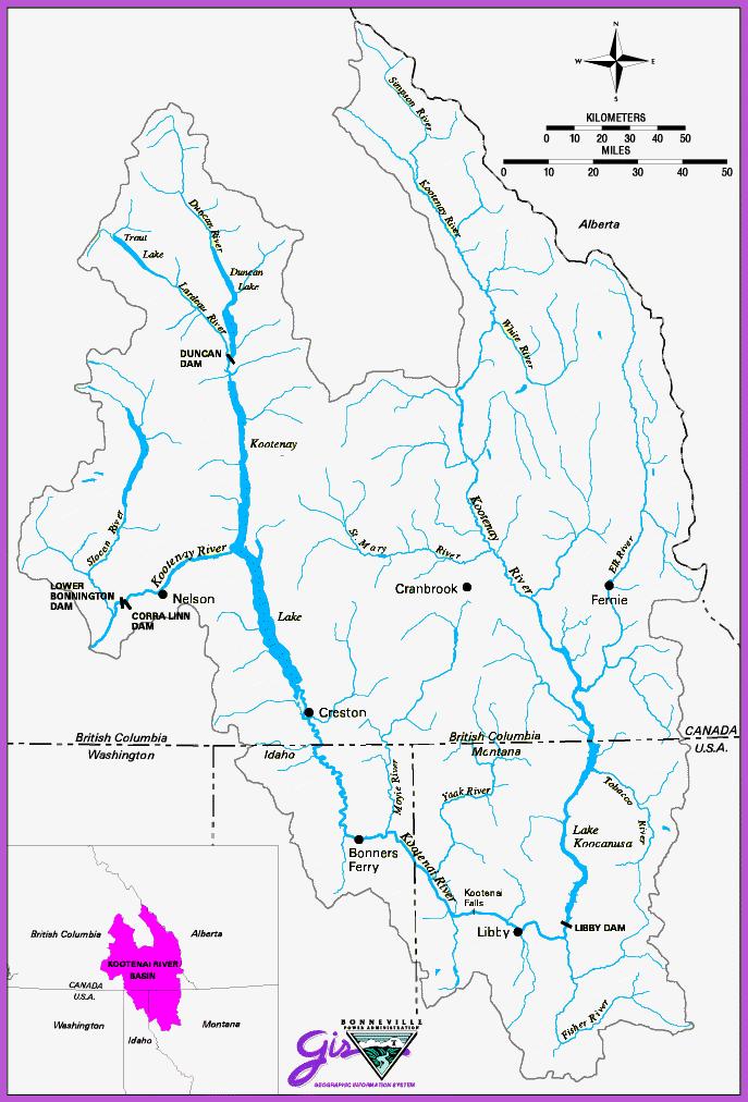
2 Kootenay(Kootenai) Basin 2


3 IJC Context Boundary Waters Treaty 1909 Treaty Between the United States and Great Britain (for Canada) International Joint Commission (IJC) Corra Linn Dam IJC Kootenay Lake Order of Approval International Kootenay Lake Board of Control


4 International Joint Commission Lana Pollack U.S., Chair Gordon Walker Canada, Chair Dereth Glance, U.S. Rich Moy, U.S. Richard Morgan, Canada Benoit Bouchard, Canada
5 International Joint Commission To prevent and resolve Canada/US water issues, the Commission Receives applications and references on transboundary issues Notifies public, undertakes studies and holds hearings to inform decision Issues Orders (e.g IJC Order for Kootenay Lake) Issues recommendations (i.e. for reference cases) The Commission appoints Boards of Control to monitor compliance with terms of IJC Orders
6 Kootenay Lake Board of Control Duties of the Kootenay Lake Board of Control Monitor FortisBC s operation of Corra Linn Dam for compliance with terms of IJC Order (e.g. maximum water levels on Kootenay Lake) Assure all other provisions of the 1938 IJC Order are followed Hold annual meetings, report and provide general support to the IJC on issues relating to the 1938 IJC Order

7 1938 Kootenay Lake Order Kootenay River and Corra Linn Dam International Kootenay Lake Board of Control Kootenay Lake Order relates to Corra Linn Dam (FortisBC). 1929: West Kootenay Power sought IJC approval for Corra Linn Dam & 6 ft of water storage in Kootenay Lake. 1938: IJC Order of Approval for Corra Linn Dam Required excavation at Grohman Narrows Issue: The dam can affect Kootenay Lake levels and cause backwater effect up Kootenai River into Idaho. Article IV of Boundary Waters Treaty applies Kootenai River Valley, Idaho

8 1938 Kootenay Lake Order Directs FortisBC to help pay Idaho farmers to offset increased pumping costs for land drainage

 to dredge")

9 1938 Kootenay Lake Order Directed original Applicant (WKPL) to dredge Grohman Narrows (completed in the early 1940s)

10 1938 Kootenay Lake Order Directs FortisBC to take advantage of the channel improvement at Grohman Narrows to lower peak water levels on Kootenay Lake
11 Kootenay Lake Control Corra Linn Control Grohman Narrows Control Kootenay Lake (West Arm) Lake level depends on balance of inflow and outflow Corra Linn dam does not have exclusive control of lake outflow Corra Linn Grohman Narrows Nelson Queens Bay When the Corra Linn forebay is kept low, control moves upstream to the channel constriction at Grohman Narrows


12 1938 Kootenay Lake Order Maximum Water Elevations Ordered International Kootenay Lake Board of Control Drawdown Period Queens Bay Lowering Formula Freshet Period Spring Rise Nelson Storage Queens Bay Jan Apr Aug Sep Dec
13 Stage (feet) International Kootenay Lake Board of Control Kootenay Lake in ,758 1,756 1,754 1,752 1,750 Corra Linn control Grohman Narrows control 2012 High Water Rule Curve Queens Bay 0 1,748 Major Rain Events Nelson Balanced control 1,746 1,744 1, ,740 1,738 J F M A M J J A S O N D Commencement of spring rise 2015/04/02 13
14 Precip.(mm) Temp. ( C) Precipitation Anomalies Kaslo - Precipitation 2015 Benchmark - Climate Normal ( ) ClimNorm_Daily Maximum ( C) Total Rain (mm) Total Snow (cm) Max Temp ( C)
15 Stage (feet) Kootenay Lake in ,758 1,756 Corra Linn control 0 1,754 1,752 1,750 Peak water: ft (July 3 rd ) Grohman Narrows control Rule Curve Queens Bay Nelson 1,748 Balanced control 1,746 1,744 1,742 1,740 1,738 Commencement of spring rise 2012/04/20 J F M A M J J A S O N D Month
16 Stage (feet) International Kootenay Lake Board of Control Water Level Extremes: Kootenay Lake (Queen s Bay) Lowering enabled by dredging 1929 Condition Grohman 1 Modelled Narrows Maximum 9 Maximum: ft (1961) 1760 Duncan Dam (1967) 1755 Libby Dam (1975) Maximum Daily Water Level Max Pre-Libby range: feet 1740 Minimum Daily Water Level Max. Post-Libby range: feet Minimum: ft (1944) Year 16
17 Summary IJC Order dictates maximum water level conditions on Kootenay Lake. To date, exceedances have been due to natural climate effects and influence of upstream CRT operations (no cases of non-compliance). The CRT operations reference the IJC Order The range of water level variation on Kootenay Lake has been reduced following development of upstream CRT dams El Niño: winter rain storms & run-off events (exceedances of IJC rule curve) and low peak water levels on Kootenay Lake high water conditions: more manageable winter conditions but early onset of lake rise due to upstream CRT flood management operations. Grohman Narrows is limiting factor on Kootenay Lake discharge during high water periods. 17
18 Thank-you! Comments/Questions? 18
MINUTES. International Kootenay Lake Board of Control Public Meeting. Kootenai River Inn 7169 Plaza Street Bonners Ferry, Idaho
 MINUTES Public Meeting Kootenai River Inn 7169 Plaza Street Bonners Ferry, Idaho Wednesday, September 26, 2012 7:30-9:30 PM Attendance United States Canada Chairs Col. Bruce Estok (host) Kirk Johnstone
RECORD OF MEETING OF THE INTERNATIONAL KOOTENAY LAKE BOARD OF CONTROL ANNUAL MEETING AT BONNERS FERRY, IDAHO
 October 25, 2002 RECORD OF MEETING OF THE INTERNATIONAL KOOTENAY LAKE BOARD OF CONTROL ANNUAL MEETING AT BONNERS FERRY, IDAHO September 26, 2002, 2:00 PM KOOTENAI RIVER INN Attendance Canada United States
Albeni Falls Dam Downstream Water Temperature Study Interim Results
 Albeni Falls Dam Downstream Water Temperature Study Interim Results Amy Reese, Chief Water Management Section Seattle District June 24, 2014 US Army Corps of Engineers What we hope to cover today Albeni
Presented to Idaho Washington Aquifer Collaborative February 11, Spokane River Project License
 Presented to Idaho Washington Aquifer Collaborative February 11, 2014 Spokane River Project License Contact Speed Fitzhugh, Spokane River License Manager Telephone - (509) 495-4998 Email - speed.fitzhugh@avistacorp.com
Adopted Regulation Strategy LWCB Regulation Meeting - March 22, 2010
 Adopted Regulation Strategy LWCB Regulation Meeting - March 22, 2010 The Lake of the Woods Control Board held a Regulation Meeting in Kenora on March 25, 2010 and adopted the following strategy. The strategy
Adopted Regulation Strategy Lake of the Woods Control Board Regulation Meeting March 12, 2013
 Adopted Regulation Strategy Lake of the Woods Control Board Regulation Meeting March 12, 2013 The Lake of the Woods Control Board held a Regulation Meeting March 12, 2013 in Kenora. The strategy was formulated
CCoWS. Central Coast Watershed Studies. Summary of Precipitation and Streamflow for Potrero and San Clemente Creeks in 2010
 Central Coast Watershed Studies CCoWS Summary of Precipitation and Streamflow for Potrero and San Clemente Creeks in Water-Year 2010 Santa Lucia Preserve Monterey County, California Publication No. WI-2011-01
Hydrological Condition Report including the issues of High Flow Fluctuation in Chiang Saen
 Hydrological Condition Report including the issues of High Flow Fluctuation in Chiang Saen Technical Symposium for ESCIR and MRC on Social Impact Assessment in River Basin Management Sothea KHEM, HENG
PROFILE OF SACRAMENTO RIVER, FREEPORT TO VERONA, CALIFORNIA,
 PROFILE OF SACRAMENTO RIVER, FREEPORT TO VERONA, CALIFORNIA, FLOOD OF FEBRUARY 1986 By J.C. Blodgett and J.B. Lucas U.S. GEOLOGICAL SURVEY Open-File Report 88-82 CO CM I m r-h CM Sacramento, California
APPENDIX H LAKE OKEECHOBEE FLOOD ROUTINES
 1 2 3 APPENDIX H LAKE OKEECHOBEE FLOOD ROUTINES 1 2 3 4 5 6 7 8 9 10 11 12 13 14 15 16 17 18 19 20 21 22 23 24 25 26 27 28 29 30 31 32 33 34 35 36 37 38 39 40 41 42 43 44 45 LAKE OKEECHOBEE FLOOD ROUTINGS
Weather and Climate Impacts on Water Supply
 Weather and Climate Impacts on Water Supply Nolan Doesken Colorado Climate Center Atmospheric Science Department Colorado State University http://ccc.atmos.colostate.edu Presented at the South Platte Forum,
Drought: What is the Status?
 Drought: What is the Status? Nolan J. Doesken Colorado Climate Center Colorado State University http://ccc.atmos.colostate.edu Presented at 2005 Peak to Prairie Landscape Symposium, February 11, 2005,
Drought and the Climate of the Ogallala Aquifer
 Drought and the Climate of the Ogallala Aquifer Nolan J. Doesken Colorado Climate Center Colorado State University Presented at Ogallala Symposium, Wray, Colorado February 20, 2006 Prepared by Odie Bliss
Water budgets of the two Olentangy River experimental wetlands in 2001
 Water Budgets 23 Water budgets of the two Olentangy River experimental wetlands in 2001 Li Zhang and William J. Mitsch School of Natural Resources, The Ohio State University Introduction Hydrologic conditions
Great Lakes Commission Semiannual Meeting
 Great Lakes Commission Semiannual Meeting Great Lakes Water Levels Forecasts March 6, 2013 Washington D.C. Keith Kompoltowicz Chief, Watershed Hydrology Detroit District Corps of Engineers Recent Analysis/Forecast
Drought or Not? Nolan J. Doesken Colorado Climate Center Colorado State University
 Drought or Not? Nolan J. Doesken Colorado Climate Center Colorado State University http://ccc.atmos.colostate.edu Presented at Horticultural Art Society meeting, November 19, 2004, Colorado Springs, Colorado
Colorado River Drought Response and System Sustainability. Chuck Cullom July 16, 2014
 Colorado River Drought Response and System Sustainability Chuck Cullom July 16, 2014 Study Structure and Schedule Summary of Key Activities Upcoming Meetings Further Discussion, Follow-up Colorado River
Inner Harbor Navigation Canal (IHNC) Basin 1% (100-yr) and 0.2% (500-yr) Surge and Wave Event Water Levels
 Basin 1% (100-yr) and 0.2% (500-yr) Surge and Wave Event Water Levels") Inner Harbor Navigation Canal (IHNC) Basin 1% (100-yr) and 0.2% (500-yr) Surge and Wave Event Water Levels Dr. John Grieshaber Hurricane Protection Office US Army Corps of Engineers Overview The IHNC basin
Inner Harbor Navigation Canal (IHNC) Basin 1% (100-yr) and 0.2% (500-yr) Surge and Wave Event Water Levels Dr. John Grieshaber Hurricane Protection Office US Army Corps of Engineers Overview The IHNC basin
Drought! When Do We Know It s Over?
 Drought! When Do We Know It s Over? Nolan J. Doesken Colorado Climate Center Colorado State University http://ccc.atmos.colostate.edu Presented at the 2004 Peak to Prairie Landscape Symposium, February
Recent Environmental Conditions and BC Salmon Outlook to 2020
 Recent Environmental Conditions and BC Salmon Outlook to 2020 K. Hyatt & S. Grant Pacific Biological Station, Nanaimo Contributors: I. Perry, L. Weitkamp, M. Galbraith, J. Boldt, P. Chandler, S. King,
Table 1. Monthly precipitation totals from the on-site rain gage and from the Dulles weather station and their differences.
 Table 1. Monthly precipitation totals from the on-site rain gage and from the Dulles weather station and their differences. Precipitation Month On-Site Rain Dulles Weather Difference Ratio 1996-97 Gage
LESOTHO HIGHLANDS DEVELOPMENT AUTHORITY
 LESOTHO HIGHLANDS DEVELOPMENT AUTHORITY FLOW RELEASES DOWNSTREAM OF THE LESOTHO HIGHLANDS WATER PROJECT (LHWP) STRUCTURES (April 2003 to September 2003) TOWER ON MALIBAMATŠO RIVER @ KAO MARCH 2004 OPERATIONS,
First Foods. Salmon. Berries Water Game. Roots
 Tribal Perspectives on the Columbia River Treaty Paul Lumley (Yakama), Executive Director Columbia River Inter-Tribal Fish Commission 1 First Foods Salmon Berries Water Game Roots the right of taking fish
NUMERICAL AND PHYSICAL MODELING
 POINTE DU BOIS GENERATING STATION SPILLWAY REPLACEMENT PROJECT NUMERICAL AND PHYSICAL MODELING Kara Hurtig, Northwest Hydraulic Consultants, North Vancouver, BC, Canada David S. Brown, KGS Group, Winnipeg,
Kootenai River Habitat Restoration Program. Kootenai Tribe of Idaho - January 27, 2014 Presentation for Kootenai Valley Resource Initiative
 Kootenai River Habitat Restoration Program Kootenai Tribe of Idaho - January 27, 2014 Presentation for Kootenai Valley Resource Initiative Decline of native species Kootenai River White Sturgeon ENDANGERED
Lower Coquitlam River Project Water Use Plan. Temperature Monitoring Lower Coquitlam River Project Year 2 Report
 Lower Coquitlam River Project Water Use Plan Temperature Monitoring Lower Coquitlam River Project Year 2 Report COQMON#6 Temperature Monitoring Study Lower Coquitlam River Study Period: Year 2-2007 Report
STRUCTURE S-65 PURPOSE SPILLWAY OPERATION
 STRUCTURE S-65 This structure is a reinforced concrete, gated spillway with discharge controlled by three cable operated, vertical lift gates, and a reinforced concrete lock structure with two pairs of
MBMG Butte Mine Flooding Monthly Report BMFOU Consent Decree BU-SEH Remedial Action Monitoring Program Contract No TO-35 September 2013
 MBMG Monthly Report BMFOU Consent Decree 02-35-BU-SEH Remedial Action Monitoring Program Contract No. 400022-TO-35 September 20 The Montana Bureau of Mines and Geology (MBMG) continued to perform monitoring
Environmental Protection The answer my friend is blowing in the wind
 Environmental Protection The answer my friend is blowing in the wind Nolan Doesken Colorado Climate Center Colorado State University Presented at the Pesticide Conference, November 17, 2005, Denver, CO
Coquitlam/Buntzen Project Water Use Plan
 Coquitlam/Buntzen Project Water Use Plan Temperature Monitoring Lower Coquitlam River Project Year 3 Report Reference: COQMON#6 Study Period: March 2008 April 2009 Report Date: April 2009 Trow Associates
The State of the Climate Address
 The State of the Climate Address Nolan J. Doesken Colorado Climate Center, Atmospheric Science Dept, Colorado State University Presented to Colorado Water Officials Association, 2005 Annual Meeting, September
Nolan Doesken. Colorado Climate Center.
 Nolan Doesken Colorado Climate Center Presented to: Colorado Conservation Tillage Association, Greeley, CO, February 1-2, 1 2005 http://ccc.atmos.colostate.edu Prepared by Odie Bliss 1 Key Features of
Os eventos extremos estão aumentando na Amazônia? Javier Tomasella e José A. Marengo. Centro de Ciência do Sistema Terrestre, INPE
 Os eventos extremos estão aumentando na Amazônia? Javier Tomasella e José A. Marengo Centro de Ciência do Sistema Terrestre, INPE Hamburgo, Março 2011 The Amazon Basin River Drainage area (km 2 ) Rainfall
IX. Upper Ocean Circulation
 IX. Upper Ocean Circulation World Ocean Covers 71% of Earth s surface Contains 97% of surface water Arctic Ocean NH: 61% ocean, 39% land Pacific Ocean Atlantic Ocean Southern Ocean Indian Ocean SH: 81%
CoCoRaHS goes to the Colorado Farm Show
 CoCoRaHS goes to the Colorado Farm Show Nolan J. Doesken Colorado Climate Center, Atmospheric Science Dept, Colorado State University Presented January 25, 2006, Greeley, CO Prepared by Odie Bliss The
Wisconsin 511 Traveler Information Annual Usage Summary January 3, Wisconsin 511 Phone Usage ( )
") Wisconsin 511 Traveler Information 211 Annual Usage Summary January 3, 212 Overall to-date Summary 36 months of operation 1,16,63 total calls the 1 Million mark was passed on December 3, 212 3,627,527
Wisconsin 511 Traveler Information 211 Annual Usage Summary January 3, 212 Overall to-date Summary 36 months of operation 1,16,63 total calls the 1 Million mark was passed on December 3, 212 3,627,527
Design Criteria Data
 MEMPHIS TN Latitude = 35.35 N WMO No. 723345 Longitude = 89.87 W Elevation = 322 feet Period of Record = 1973 to 1996 Average Pressure = 29.68 inches Hg Design Criteria Data Mean Coincident (Average) Values
Design Criteria Data
 FRESNO CA Latitude = 36.77 N WMO No. 72389 Longitude =119.7 W Elevation = 328 feet Period of Record = 1972 to 1996 Average Pressure = 29.62 inches Hg Design Criteria Data Mean Coincident (Average) Values
Properties. terc.ucdavis.edu 8
 Physical Properties 8 Lake surface level Daily since 1900 The lowest lake level on record was 6,220.26 feet on Nov. 30, 1992. Since 1900, lake level has varied by more than 10 feet. Lake level typically
Environmental Conditions: Informing Salmon Returns in 2019
 DFO State of the Salmon Program Environmental Conditions: Informing Salmon Returns in 2019 Sue Grant & Bronwyn MacDonald Developing Tools and Processes to Foster Salmon-Ecosystem integration Contact: Sue.Grant@dfo-mpo.gc.ca
Design Criteria Data
 TUCUMCARI NM Latitude = 35.18 N WMO No. 723676 Longitude =13.6 W Elevation = 465 feet Period of Record = 1973 to 1996 Average Pressure = 25.86 inches Hg Design Criteria Data Mean Coincident (Average) Values
CLAIBORNE LOCK AND DAM PERTINENT DATA
 CLAIBORNE LOCK AND DAM PERTINENT DATA GENERAL Location Clarke, Monroe, & Wilcox Counties, Alabama; Alabama River, river mile 72.5 Drainage area Millers Ferry to Claiborne sq. mi. 836 Total drainage area
Fish and Wildlife Compensation Program Trevor Oussoren, program manager, Columbia region. CRT Workshop, Fauquier, June 15, 2013
 Angus Glass Fish and Wildlife Compensation Program Trevor Oussoren, program manager, Columbia region. CRT Workshop, Fauquier, June 15, 2013 The Fish and Wildlife Compensation Program is a partnership of:
Key Feature and Challenges from Climate Change for Mekong River Basin
 1 Key Feature and Challenges from Climate Change for Mekong River Basin By Dr. Thanapon Piman Planning Division Basin Development Plan Pragramme Mekong River Commission Secretariat (MRCS) 2 Outline 1)
UPDATE: Ktunaxa Nation Council efforts to restore anadromous salmon to the Canadian Columbia River basin. Lake Roosevelt Forum April 2018
 UPDATE: Ktunaxa Nation Council efforts to restore anadromous salmon to the Canadian Columbia River basin Lake Roosevelt Forum April 2018 Bill Green (bgreen@ktunaxa.org) Will Warnock (wwarnock@ccrifc.org)
Canada s Natural Systems. Canadian Geography 1202
 Canada s Natural Systems Canadian Geography 1202 Canada s Natural Systems Natural System: A system found in nature Here are the four natural systems that we will explore in the next few weeks 1. Canada
Manitoba Water Stewardship. Coping with Drought. Drought Research Initiative Workshop. Inn at the Forks, Winnipeg. A.A. Warkentin. January 11-13, 2007
 Manitoba Water Stewardship Coping with Drought Drought Research Initiative Workshop Inn at the Forks, Winnipeg A.A. Warkentin January 11-13, 2007 Annual Renewal of Water Supplies Important Precipitation-based
Eulachon: State of the Science and Science to Policy Forum
 Eulachon: State of the Science and Science to Policy Forum August 27, 2015 Robert Anderson Eulachon Recovery Coordinator National Marine Fisheries Service FCRPS, Dams, and Water Management in the Columbia
Annual Meeting June 17, Research Stewardship Education
 Annual Meeting June 17, 2016 Research Stewardship Education 1 James Chandler, Intern from St. Lawrence University Christina Morrisett, Research Assistant Melissa Muradian, Post-Graduate Research Associate
The Executive Committee of the International Fund for saving the Aral Sea (EC IFAS)
") International Fund for saving the Aral Sea (EC IFAS) Aral Sea The Executive Committee of the the 60th of the 20th century Aral Sea The Executive Committee of the The beginning of ХI century Aral Sea The
International Fund for saving the Aral Sea (EC IFAS) Aral Sea The Executive Committee of the the 60th of the 20th century Aral Sea The Executive Committee of the The beginning of ХI century Aral Sea The
Colorado Weather and Climate Update
 Colorado Weather and Climate Update Nolan J. Doesken State Climatologist Colorado Climate Center, Atmospheric Science Department, Colorado State University Presented to Colorado Livestock Association,
IWRM of Ganges-Brahmaputra-Meghna Basin
 8th NARBO IWRM Training, 27 November 4 December 2013, Sri Lanka. Welcome to Group Presentation IWRM of Ganges-Brahmaputra-Meghna Basin Presented by : Musa Nurur Rahman Country : Bangladesh 4 December,
APPENDIX A STRUCTURE DESCRIPTIONS AND RATING CURVES
 3 4 5 6 7 8 9 0 3 APPENDIX A STRUCTURE DESCRIPTIONS AND RATING CURVES Kissimmee River Vol December 005 Version Draft 4 3 4 5 6 7 8 9 0 3 4 5 6 7 8 9 0 3 4 5 6 7 8 9 30 3 3 33 34 35 36 37 38 39 40 4 4 43
Tuesday, January 11, :11 AM (CST)
") Tuesday, January 11, 2011 11:11 AM (CST) -Assessment of current water conditions - Precipitation Forecast - Recommendations for Drought Monitor Upper Colorado Normal Precipitation Upper Colorado River
Tuesday, January 11, 2011 11:11 AM (CST) -Assessment of current water conditions - Precipitation Forecast - Recommendations for Drought Monitor Upper Colorado Normal Precipitation Upper Colorado River
National Renewable Energy Laboratory. Wind Resource Data Summary Guam Naval Ordnance Annex Data Summary and Retrieval for November 2009
 National Renewable Energy Laboratory Wind Resource Data Summary Guam Naval Ordnance Annex Data Summary and Retrieval for November 2009 Prepared for: National Renewable Energy Laboratory 1617 Cole Boulevard
Buckland Wind Resource Report
 Buckland Wind Resource Report By: Douglas Vaught, P.E., V3 Energy LLC, Eagle River, Alaska Date: September 17, 2010 Buckland met tower; D. Vaught photo Contents Summary... 2 Test Site Location... 2 Photographs...
CORPS FACTS. Harbor Dredging U.S. ARMY CORPS OF ENGINEERS BUILDING STRONG
 CORPS FACTS Harbor Dredging U.S. ARMY CORPS OF ENGINEERS BUILDING STRONG Disaster Response Sedimentation in the channel is caused by the normal cycle of silt movement, erosion from high water or heavy
Kodiak, Alaska Site 1 Wind Resource Report
 Kodiak, Alaska Site 1 Wind Resource Report Report written by: Douglas Vaught, P.E., V3 Energy LLC, Eagle River, AK Date of report: March 16, 2007 Photo by Doug Vaught, V3 Energy LLC Summary Information
Crop Weather Outlook 2012 What Follows A Strong La Niña?
 Crop Weather Outlook 2012 What Follows A Strong La Niña? Elwynn Taylor www.twitter.com/elwynntaylor 1/12/2012 US Corn 147.2 BPA (9.24K/ha) soy 41.5BPA (2.79K/ha) http://www1.ncdc.noaa.gov/pub/data/cmb/extremes/summer-2011-days-over-100.png
BANGLADESH: TRANSBOUNDARY RIVERS PROBLEMS AND PROSPECTS
 BANGLADESH: TRANSBOUNDARY RIVERS PROBLEMS AND PROSPECTS by Md. Jahid Hossain Jahangir Executive Engineer Joint Rivers Commission, Bangladesh Presented at the Expert Scoping Workshop on quantifying the
Press Release New Bilateral Agreement May 22, 2008
 Informational Report 3 June 2008 Press Release New Bilateral Agreement May 22, 2008 The Pacific Salmon Commission is pleased to announce that it has recommended a new bilateral agreement for the conservation
Monitoring Surfing Quality Below the Jordan River Generating Station (Year 3)
") Jordan River Water Use Plan Monitoring Surfing Quality Below the Jordan River Generating Station (Year 3) Reference: JORMON-5 Monitoring Surfing Quality Below the Jordan River Generating Station Study
Jordan River Water Use Plan Monitoring Surfing Quality Below the Jordan River Generating Station (Year 3) Reference: JORMON-5 Monitoring Surfing Quality Below the Jordan River Generating Station Study
Nolan Doesken Colorado Climate Center
 Nolan Doesken Colorado Climate Center Presented to: Colorado Cattleman s s Association, Pueblo, CO, June 19, 2006 http://ccc.atmos.colostate.edu Prepared by Odie Bliss 1 Let s s Talk About Precipitation
Aspects and Case Studies of the Effects of Climate Change on Water Resources. Part II (Case Studies)
") Aspects and Case Studies of the Effects of Climate Change on Water Resources Part II (Case Studies) Manfred Koch Department of Geohydraulics and Engineering Hydrology, University of Kassel, Germany Email:
Aspects and Case Studies of the Effects of Climate Change on Water Resources Part II (Case Studies) Manfred Koch Department of Geohydraulics and Engineering Hydrology, University of Kassel, Germany Email:
WHEREAS, the ordinance will not create excessive additional requirements for public facilities and services at public cost.
 ORDINANCE 19-05 AN ORDINANCE OF VALLEY COUNTY, IDAHO, CREATING AN ORDINANCE TO BE ADMINISTERED BY THE VALLEY COUNTY SHERIFF S OFFICE AND TO BE KNOWN AS VALLEY COUNTY WATERWAYS ORDINANCE THAT INCLUDES PAYETTE
OFFICE OF STRUCTURES MANUAL FOR HYDROLOGIC AND HYDRAULIC DESIGN CHAPTER 11 APPENDIX B TIDEROUT 2 USERS MANUAL
 OFFICE OF STRUCTURES MANUAL FOR HYDROLOGIC AND HYDRAULIC DESIGN CHAPTER 11 APPENDIX B TIDEROUT 2 USERS MANUAL APRIL 2011 APRIL 2011 Page 1 Preface TIDEROUT 2, Build 1.22 dated June 29, 2006 is the current
STRUCTURE 65-B PURPOSE SPILLWAY OPERATION
 STRUCTURE 65-B This structure is a reinforced concrete, gated spillway with discharge controlled by three cable operated vertical lift gates and a reinforced concrete lock structure with two pairs of sector
 A Brief Analysis of the Impact of the El Niño Southern Oscillation (ENSO) Cycle In specific areas around East Timor In the Climate Change section of Seeds of Life, we believe it would be beneficial for
Equatorial upwelling. Example of regional winds of small scale
 Example of regional winds of small scale Sea and land breezes Note on Fig. 8.11. Shows the case for southern hemisphere! Coastal upwelling and downwelling. Upwelling is caused by along shore winds, that
Total Suspended Solids, Stable Flow, and Wet Weather Event Monitoring in the Bass River Watershed. December The Cadmus Group, Inc.
 Total Suspended Solids, Stable Flow, and Wet Weather Event Monitoring in the Bass River Watershed December 2004 The Cadmus Group, Inc. Grand Valley State University Annis Water Resources Institute Submitted
Response of a Newly Created Marsh-Wetland Affected by Tidal Forcing, Upland Discharge, and Groundwater Interaction
 Response of a Newly Created Marsh-Wetland Affected by Tidal Forcing, Upland Discharge, and Groundwater Interaction Mouth of Columbia River, Cape Disappointment State Park, Washington 12 Hans R. Moritz
Climate Change and Hydrology in the Sierra Nevada. Lorrie Flint U.S. Geological Survey Sacramento CA
 Climate Change and Hydrology in the Sierra Nevada Lorrie Flint U.S. Geological Survey Sacramento CA Discussion Topics Climate change for California Methods to evaluate hydrologic impacts Water balance
Upper Columbia Salmon Restoration: Breakout session: Columbia River Treaty Review Conference Castlegar, BC March 22 nd, 2013
 Upper Columbia Salmon Restoration: Breakout session: Columbia River Treaty Review Conference Castlegar, BC March 22 nd, 2013 Bill Green Canadian Columbia River Intertribal Fisheries Commission Session
DG AGRI DASHBOARD: CITRUS FRUIT Last update:
 14 000 12 000 10 000 8 000 6 000 4 000 2 000 0 1996 1997 1998 1999 2000 2001 2002 2003 2004 2005 2006 2007 2008 2009 2010 2011 2012 2013 2014 2015 2016 Small citrus (group mandarines): clementines, satsumas
LIFE HISTORY DIVERSITY AND RESILIENCE
 LIFE HISTORY DIVERSITY AND RESILIENCE SPRING CHINOOK IN THE WILLAMETTE RIVER BASIN Kirk Schroeder Brian Cannon Luke Whitman Paul Olmsted Oregon Department of Fish and Wildlife Corvallis Research Lab Thanks
Total Suspended Solids, Stable Flow, and Wet Weather Event Monitoring in the Unnamed Tributary to the Grand River Watershed.
 Total Suspended Solids, Stable Flow, and Wet Weather Event Monitoring in the Unnamed Tributary to the Grand River Watershed December 2004 The Cadmus Group, Inc. Grand Valley State University Annis Water
Ninilchik Harbor Page 2 of 11
 Ninilchik Harbor Ninilchik Harbor Page 2 of 11 Condition of Improvements 31 December 2017 Ninilchik Harbor, Alaska (CWIS No. 012640, 087345) Authorization Rivers and Harbors Act, 3 July 1958 (P.L. 85-500
Order No. 55/18 CENTRA GAS MANITOBA INC.: PRIMARY GAS RATE APPLICATION, EFFECTIVE MAY 1, April 26, 2018
 CENTRA GAS MANITOBA INC.: PRIMARY GAS RATE APPLICATION, EFFECTIVE MAY 1, 2018 BEFORE: Larry Ring, Q.C., Panel Chair Marilyn Kapitany, B.Sc.(Hon), M.Sc., Vice Chair Carol Hainsworth, C.B.A., Member Susan
Cover photos: Left: Edward Moran, hydrologist with the U.S. Geological Survey, Alaska Science Program, is setting up a survey-grade global
 Cover photos: Left: Edward Moran, hydrologist with the U.S. Geological Survey, Alaska Science Program, is setting up a survey-grade global positioning system on a Natural Resources Canada-Geodetic Survey
Atqasuk Wind Resource Report
 Atqasuk Wind Resource Report Report by: Douglas Vaught, P.E., V3 Energy LLC, Eagle River, Alaska Date of Report: August 26, 2010 Atqasuk met tower; D. Vaught photo Contents Summary... 2 Test Site Location...
Water budgets of the two Olentangy River experimental wetlands in 1998
 Water budgets of the two Olentangy River experimental wetlands in 1998 Naiming Wang and William J. Mitsch School of Natural Resources The Ohio State University Water Budgets 17 Introduction An understanding
January 3, Presenters: Laurie Weitkamp (Northwest Fisheries Science Center), Patty O Toole
, Patty O Toole") Henry Lorenzen Chair Oregon Bill Bradbury Oregon Guy Norman Washington Tom Karier Washington W. Bill Booth Vice Chair Idaho James Yost Idaho Jennifer Anders Montana Tim Baker Montana January 3, 2018 MEMORANDUM
Henry Lorenzen Chair Oregon Bill Bradbury Oregon Guy Norman Washington Tom Karier Washington W. Bill Booth Vice Chair Idaho James Yost Idaho Jennifer Anders Montana Tim Baker Montana January 3, 2018 MEMORANDUM
windnavigator Site Analyst Report
 windnavigator Site Analyst Report for Central NY Created for Stephen Meister April 27, 2010 ID NUMBER: N2-128 AWS Truepower, LLC Albany - Barcelona - Bangalore p: +1.518.21.00 e: info@awstruepower.com
Kootenay Lake Update and Actions Matt Neufeld and Jeff Burrows Ministry of Forests, Lands and Natural Resource Operations - Nelson
 Kootenay Lake Update and Actions 2015 Matt Neufeld and Jeff Burrows Ministry of Forests, Lands and Natural Resource Operations - Nelson History Leading to 2015 Kokanee Gerrard Rainbow Kootenay Lake Fishery
The Effects of Seasonal Stream Dewatering on Bull Trout, Salvelinus confluentus
 The Effects of Seasonal Stream Dewatering on Bull Trout, Salvelinus confluentus Thesis Presentation and Defense By William R. Meyer Central Washington University Introduction Bull trout life history The
Name: Date: Day/Period: CGC1P1: Interactions in the Physical Environment. Factors that Affect Climate
 Name: Date: Day/Period: CGC1P1: Interactions in the Physical Environment PART A: Weather and Climate Factors that Affect Climate 1. The words weather and climate are often incorrectly used interchangeably.
Enclosure 16. Memorandum for Record Informal Consultation Telecon 12 March 2004
 Enclosure 16 Memorandum for Record Informal Consultation Telecon 12 March 2004 MEMORANDUM FOR RECORD 1. On Tuesday, 9 March 2004, the US Army Corps of Engineers, Mobile District, Water Management Section
OPTIMUM ESCAPEMENT GOALS FOR CHINOOK SALMON IN THE TRANSBOUNDARY ALSEK RIVER
 Canadian Science Advisory Secretariat Science Advisory Report 2011/019 OPTIMUM ESCAPEMENT GOALS FOR CHINOOK SALMON IN THE TRANSBOUNDARY ALSEK RIVER Chinook salmon adult spawning phase. DFO website. Figure
The Blob, El Niño, La Niñas, and North Pacific marine ecosystems
 The Blob, El Niño, La Niñas, and North Pacific marine ecosystems Laurie Weitkamp Northwest Fisheries Science Center Newport Field Station NOAA Fisheries Laurie.weitkamp@noaa.gov Bill Peterson s Big Picture:
1.3: CLIMATE GEOGRAPHY. pgs
 1.3: CLIMATE GEOGRAPHY pgs. 76-89 INTRODUCTION WEATHER: Is the combination of temperature, precipitation, cloud cover and wind that we experience EACH DAY. Example: 22 0 C and clear skies. CLIMATE: The
TANBREEZ PROJECT CLIMATE AND HYDROLOGY AUGUST 2013 TANBREZ MINING GREENLAND A/S
 TANBREZ MINING GREENLAND A/S TANBREEZ PROJECT CLIMATE AND HYDROLOGY AUGUST 2013 Orbicon A/S Ringstedvej 20 DK 4000 Roskilde Denmark Phone + 45 46 30 03 10 Version Draft 1.2 Date 6. August 2013 Prepared
MAR DASHBOARD MAR. Compliant % Breakdown Mar % Late % On-time MAR APR MAY JUN JUL AUG SEP OCT NOV DEC
 Positive Response Compliance 215 Compliant 215 Non-Compliant 216 Compliant 216 Non-Compliant 1% 87% 96% 86% 96% 88% 97% 89% 89% 88% 86% 92% 93% 94% 96% 94% 8% 6% 4% 2% 13% JAN 4% 14% FEB 4% 12% 3% 11%
Plan B Dam Breach Assessment
 Plan B Dam Breach Assessment Introduction In support of the Local Sponsor permit applications to the states of Minnesota and North Dakota, a dam breach analysis for the Plan B alignment of the Fargo-Moorhead
Sockeye Transboundary Collaborations developed through the Columbia Basin Accords
 Sockeye Transboundary Collaborations developed through the Columbia Basin Accords Jeffrey K. Fryer, Columbia River Inter-Tribal Fish Commission Richard Bussanich, Okanagan Nation Alliance 2017 Washington-British
FISH PASSAGE CENTER 2013 ANNUAL REPORT DRAFT
 FISH PASSAGE CENTER 2013 ANNUAL REPORT DRAFT This report responds to the Fish Passage Center annual reporting requirements to the Northwest Power and Conservation Council under its Columbia River Basin
Jordan River Project Water Use Plan
 Jordan River Project Water Use Plan Monitoring Surfing Quality below the Jordan River Generating Station Implementation Year 5 Reference: JORMON-5 Study Period: March 5 to April 1, RRL Recreation Resources
Salmon and Migratol~Y Trout of the N,anaimo 'River lind Adjacent Streams (Revised 1,973)
") .. '.' ~! ~j-:-t. ~" I. This s~rie~ includes " unpublished preliminary' reports. ana Glatd rec
.. '.' ~! ~j-:-t. ~" I. This s~rie~ includes " unpublished preliminary' reports. ana Glatd rec
March 6, SUBJECT: Briefing on Columbia River Basin salmon and steelhead returns for 2017 and run forecasts for 2018
 James Yost Chair Idaho W. Bill Booth Idaho Guy Norman Washington Tom Karier Washington Jennifer Anders Vice Chair Montana Tim Baker Montana Ted Ferrioli Oregon Richard Devlin Oregon March 6, 2018 MEMORANDUM
Water Storage for Agriculture
 Water Storage for Agriculture Ted van der Gulik, P.Eng. Partnership for Water Sustainability in BC Water Storage Options Dam! usually constructed within a watercourse! must follow the dam safety regulation!
Wind Resource Assessment for NOME (ANVIL MOUNTAIN), ALASKA Date last modified: 5/22/06 Compiled by: Cliff Dolchok
, ALASKA Date last modified: 5/22/06 Compiled by: Cliff Dolchok") 813 W. Northern Lights Blvd. Anchorage, AK 99503 Phone: 907-269-3000 Fax: 907-269-3044 www.akenergyauthority.org SITE SUMMARY Wind Resource Assessment for NOME (ANVIL MOUNTAIN), ALASKA Date last modified:
813 W. Northern Lights Blvd. Anchorage, AK 99503 Phone: 907-269-3000 Fax: 907-269-3044 www.akenergyauthority.org SITE SUMMARY Wind Resource Assessment for NOME (ANVIL MOUNTAIN), ALASKA Date last modified: