Indiana University Campus Bus Service. Bus Stop Consolidation
|
|
|
- Simon Foster
- 5 years ago
- Views:
Transcription
1 Indiana University Campus Bus Service Bus Stop Consolidation Logan Garrett 3/17/2011
2 1 Contents Overview... 3 Campus Core... 3 Third Street (Between Jordan Ave. and Indiana Ave.)... 3 Current Stop Spacing... 4 Proposed Stop Spacing... 4 Indiana Avenue... 4 Current Stop Spacing... 5 Proposed Stop Spacing... 5 Seventh Street (Core)... 5 Current Bus Stops... 6 Proposed Bus Stops... 6 Tenth Street... 7 Current Stop Spacing... 7 Proposed Stop Spacing... 8 Jordan Avenue (Core between 10 th & 3 rd )... 8 Current Bus Stops... 8 Proposed Bus Stops... 9 A Route... 9 Current Stop Spacing Proposed Stop Spacing B Route North Jordan Extension Current Stop Spacing Proposed Stop Spacing North Jordan Current Stop Spacing Proposed Bus Stops D/E Route North of 10 th Street Current Stop Spacing Proposed Stop Spacing South of 10 th Street Current Stop Spacing... 23
3 2 Proposed Stop Spacing... 23
 Today there are 5 stops serviced by Campus Bus along this corridor. Every IU route except the X route uses these stops.")


4 3 Overview This report aims to outline the current state of bus stops on campus, the desired future state according to the Campus Master Plan (CMP), and recommendations for moving towards that plan. Campus Core Third Street (Between Jordan Ave. and Indiana Ave.) Today there are 5 stops serviced by Campus Bus along this corridor. Every IU route except the X route uses these stops. Stop Stop Features Recommendation Third St. & Jordan Ave. Bus cut-away Shelter Curb stop The CMP calls for this stop to be a major transfer point for future IU and BT routes. This stop Trash can should remain as one of two main access points to Third St. Memorial Hall Curb Stop Trash can Memorial Hall is a candidate for removal. According to the Transportation Research Board (TSB) spacing guidelines this stop is not required, and adds unnecessary delay to routes. Jordan Hall Bus cut-away Shelter Curb stop Jordan Hall should serve as one of two main access point to Third St. Jordan hall would be the end of the inbound trip for future A and B routes. Also, several other IU and BT routes currently use this stop. Swain Hall Curb Stop Swain Hall is a candidate for removal. According to the Transportation Research Board (TSB) spacing guidelines this stop is not required, and adds unnecessary delay to routes.


5 4 Third St. & Indiana Ave. Curb Stop Third St. & Indiana Ave. is should remain. It is not a primary stop, but is needed as per TSB spacing policy guidelines. As such, this stop is a candidate for feature upgrades. Current Stop Spacing Key Stop Distance to next stop Time Walking N Third St. & Jordan minutes B Memorial Hall minutes C Jordan Hall minutes D Swain Hall minutes E Third St. & Indiana minutes Proposed Stop Spacing Key Stop Distance to next stop Time Walking B Third St. & Jordan 1,148 4 minutes C Jordan Hall 1,476 4 minutes D Third St. & Indiana minutes Indiana Avenue Stop Stop Features Recommendation


 Shelter Curb stop Trash can This stop is a candidate for removal. The CMP recommends that IU buses cease servicing this area of campus.")
6 5 Indiana Ave. & Kirkwood Ave. Curb Stop Indiana & Kirkwood should remain. It is the sole stop on the western portion of the core campus loop. Current Stop Spacing Key Stop Distance to next stop Time Walking E Third St. & Jordan 1,155 4 minutes Proposed Stop Spacing There are no proposed changes along this street. Seventh Street (Core) Stop Stop Features Recommendation Seventh St. & Woodlawn Ave. Curb Stop Trash can The CMP calls for this stop to be a major transfer point for future IU and BT routes. This stop should remain as the main access point to the Indiana Memorial Union, and the proposed Woodlawn corridor. Seventh St. (between University & Forest) Shelter Curb stop Trash can This stop is a candidate for removal. The CMP recommends that IU buses cease servicing this area of campus. The X bus would stop at 7 th and Woodlawn only. Seventh St. (IU Auditorium) Curb Stop This stop is a candidate for removal. The CMP recommends that IU buses cease servicing this area of campus. The X bus would stop at 7 th and Woodlawn only.


7 6 Current Bus Stops Key Stop Distance to next stop Time Walking E Third St. & Jordan 1,127 4 minutes Proposed Bus Stops The proposal for this area is not concerned with stop spacing, but rather bus routing. All buses running the campus core loop will continue to make the 7 th and Union stop. It is proposed to remove both X route stops (F & G) above. The X bus would use the current BT stop on Woodlawn Ave. This stop is on the northwest corner of the intersection of 7 th St. and Woodlawn Ave. Current X Route Proposed X Route


8 7 Tenth Street Stop Stop Features Recommendation Tenth St. & Woodlawn Ave. Curb Stop Trash can The CMP calls for this stop to be a major transfer point for future IU and BT routes. This stop should remain as a main access point along the proposed Woodlawn corridor. Tenth St. & Walnut Grove St. Curb Stop Trash can This stop is acceptable as per TSB spacing guidelines. Herman B. Wells Library Bus cut-away Shelter Curb stop Trash can The CMP calls for this stop to be a major transfer point for future IU and BT routes. This is the biggest bus stop on campus. Current Stop Spacing Key Stop Distance to next stop Time Walking H Tenth St. & Woodlawn Ave minutes I Tenth St. & Walnut Grove St. 1,148 4 minutes J Herman B. Wells Library minutes

 spacing guidelines this stop is not required, and adds unnecessary delay to routes. Jordan Ave.")
 Curb Stop This stop is not set to be a transfer point according to the CMP.")
9 8 Proposed Stop Spacing There are no proposed stop changes along 10 th St. However, it should be noted that the 787 distance from the Wells Library stop will increase. The next stop also services the library, and is a candidate for removal. The new distance will be 955. Jordan Avenue (Core between 10 th & 3 rd ) Stop Stop Features Recommendation Herman B Wells Library Curb Stop This stop is a candidate for removal. According to the Transportation Research Board (TSB) spacing guidelines this stop is not required, and adds unnecessary delay to routes. Jordan Ave. (South of 7 th Street) Curb Stop This stop is a candidate for relocation to 10 th St. The CMP calls for a major transfer point at that location. Jordan Ave. (Musical Arts Center) Curb Stop This stop is not set to be a transfer point according to the CMP. However, if the previous stop is shifted north as recommended this stop will be required to maintain reasonable spacing as per the TSB policy. Current Bus Stops Key Stop Distance to next stop Time Walking K Herman B Wells Library minutes L Jordan Ave. (South of 7th Street) minutes M Jordan Ave. (Musical Arts Center) minutes

 1,008 3 minutes F Jordan Ave.")


10 9 *Note: Map is rotated. From left to right the map runs South to North. Proposed Bus Stops Key Stop Distance to next stop Time Walking E Jordan Ave. (South of 7th Street) 1,008 3 minutes F Jordan Ave. (Musical Arts Center) minutes A Route Stop Stop Features Recommendation 17 th & Dunn St. Curb Stop (inbound ) This stop is a candidate for removal as per TSB spacing policy. Further, the outbound stop is not safe. Alumni Center Curb Stop This stop is acceptable as per TSB spacing guidelines. Briscoe Curb stop This stop is acceptable as per TSB spacing
 Trashcan (inbound) Crosswalk This stop is")


11 10 Shelter (inbound) Trashcan (inbound) guidelines. Mcnutt/Foster Curb stop Shelter (inbound) Trashcan (inbound) Crosswalk This stop is acceptable as per TSB spacing guidelines. Kelley Business School Curb stop Crosswalk This stop is acceptable as per TSB spacing guidelines. Current Stop Spacing Key Stop Distance to next stop Time Walking A Stadium minutes B 17 th St. & Dunn St. 1,800 7 minutes C Alumni Center minutes D Briscoe 1,018 3 minutes E Mcnutt/Foster 1,061 3 minutes F Kelley School of Business minutes

12 11 Proposed Stop Spacing Key Stop Distance to next stop Time Walking A Stadium 2, minutes B Alumni Center minutes C Briscoe 1,018 3 minutes D Mcnutt/Foster 1,061 3 minutes E Kelley School of Business minutes

13 12


14 13 B Route North Jordan Extension Stop Stop Features Recommendation Fisher Court Curb Stop N/A PKP / ZBT Curb Stop This stop is a candidate for
 spacing guidelines this stop is not")


15 14 Trash Can removal. According to the Transportation Research Board (TSB) spacing guidelines this stop is not required, and adds unnecessary delay to routes. Phi Delta Theta Curb Stop Trash Can This stop should remain. It is needed as per TSB spacing policy guidelines. Kappa Sigma Curb Stop This stop should remain. It is needed as per TSB spacing policy guidelines. Phi Kappa Sigma Curb Stop This stop is a candidate for removal. According to the Transportation Research Board (TSB) spacing guidelines this stop is not required, and adds unnecessary delay to routes. Current Stop Spacing Key Stop Distance to next stop Time Walking A Fisher Court minutes B PKP / ZBT minutes C Phi Delta Theta minutes D Kappa Sigma ~623 2 minutes E/F Phi Kappa Sigma minutes

16 15 Proposed Stop Spacing Key Stop Distance to next stop Time Walking A Fisher Court minutes B Phi Delta Theta 1,149 4 minutes C Kappa Sigma 1,798 6 minutes Note: A portion of the distance from Kappa Sigma to the next stop is 17 th Street which serves no houses. No passenger would have to walk more than ~600 to reach this stop.
 Distance to next stop (North bound) Time Walking D Jordan Ave. & 17 th St. N/A 1,798 6 minutes E Jordan Ave. & Lingelbach Ln.")
17 16 North Jordan *Note: Pictures and stop information were omitted in this section due to the similarity to the extension, and the complexity of stops in this area. Current Stop Spacing Key Stop Distance to next stop (South bound) Distance to next stop (North bound) Time Walking D Jordan Ave. & 17 th St. N/A 1,798 6 minutes E Jordan Ave. & Lingelbach Ln. 1, /2 minutes F Sigma Nu N/A minutes G Kappa Delta 409 N/A 2 minutes H Sigma Phi Epsilon N/A minutes I Jordan Ave. & Law Ln. 665 N/A 2 minutes J IU Health Center N/A minutes K Jordan Ave. & 10 th St. 955 N/A 3 minutes
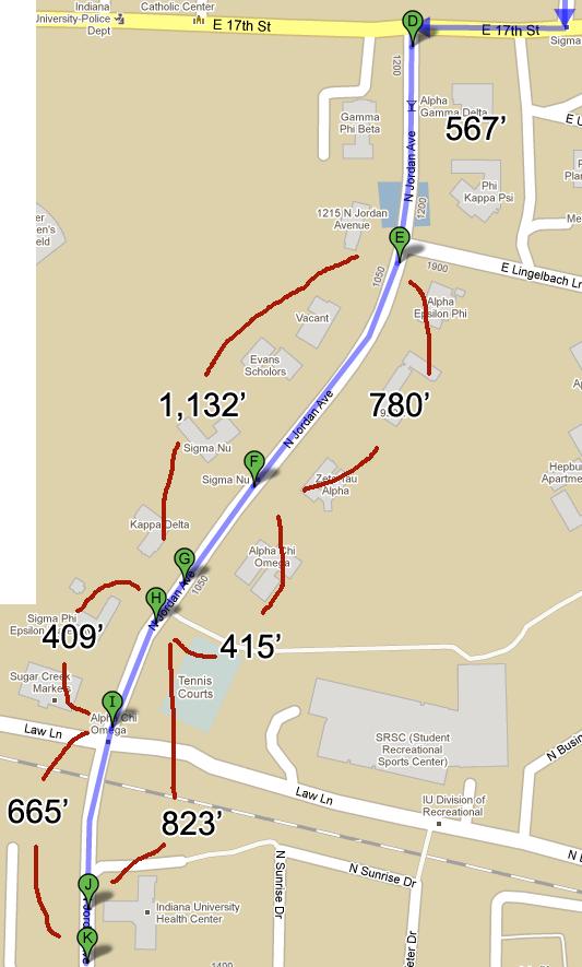
18 17

19 18 Proposed Bus Stops Key Stop Distance to next stop (South bound) Distance to next stop (North bound) Time Walking D Jordan Ave. & Lingelbach Ln. ~1,120 1,798 4/6 minutes E Kappa Delta ~1,200 N/A 4 minutes F Sigma Phi Epsilon N/A ~1,120 4 minutes G Jordan Ave. & 10 th St. 955 ~1,200 4 minutes


20 19 D/E Route North of 10 th Street Stop Stop Features Recommendation Evermann North Curb Stop N/A Trash can Bench Redbud None This stop should be reevaluated as it is not a proper bus stop. Evermann South Curb Stop Shelter This stop should be reevaluated as it serves the same areas as the two surrounding stops. Union St. Curb stop This stop is acceptable as per TSB spacing guidelines. Campus View Shelter (inbound) Curb stop This stop is acceptable as per TSB spacing guidelines.

21 20 Current Stop Spacing Key Stop Distance to next stop Time Walking A/B Evermann/Redbud 400 /635 2 minutes C Evermann South minutes D Union St minutes G Campus View minutes Proposed Stop Spacing There are no proposals for change at this time.

 7 th & Union St.")


22 21 South of 10 th Street Stop Stop Features Recommendation 10 th St. & Union St. Curb Stop Shelter This stop is acceptable as per TSB spacing guidelines. (inbound) 7 th & Union St. Curb Stop Move this stop North away from the intersection Willkie Shelter Cutaway Curb stop This stop is acceptable as per TSB spacing guidelines. Forest Curb stop Trash can This stop is acceptable as per TSB spacing guidelines. 7 th St. & Teter Dr. Curb Stop This stop is acceptable as per TSB spacing guidelines.


23 22 7 th St. & Jordan Ave. Curb stop This stop is a candidate for removal / consolidation into the planned transfer point at the intersection as per CMP and TSB spacing policy.

24 23 Current Stop Spacing Proposed Stop Spacing There are only two proposals in this area: Remove the 7 th St. stop closest to Jordan Ave. Move the inbound 7 th and Union stop to the North to give the bus more room to turn safely

25 24
Roads and Vehicular Traffic Design Principles. Roads and Vehicular Traffic Recommendations
 CIRCULATION AND PARKING roads and vehicular traffic The Campus Master Plan updates the campus transportation network through a multi-modal approach that encourages walking and biking while improving vehicular
MBTA Key Bus Route Improvement Program. Community Meeting Route 66 - Brookline
 MBTA Key Bus Route Improvement Program Community Meeting Route 66 - Brookline February 9, 2011 Brookline Town Hall, 333 Washington St., Brookline Agenda Welcome and introductions Safety briefing/accommodations
MBTA Key Bus Route. Community Meeting Route 66 - Boston
 MBTA Key Bus Route Improvement Program Community Meeting Route 66 - Boston Jackson Mann Community Center Agenda Welcome and introductions Safety briefing/accommodations Key Bus Route Program overview Existing
MBTA Key Bus Route Improvement Program. Community Meeting Route 1 - Boston
 MBTA Key Bus Route Improvement Program Community Meeting Route 1 - Boston January 24, 2011 USES, 566 Columbus Ave., Boston Agenda Welcome and introductions Safety briefing/accommodations Key Bus Route
MBTA Key Bus Route Improvement Program. Community Meeting Route 28
 MBTA Key Bus Route Improvement Program Community Meeting Route 28 April 5, 2012 Boston Public Library Mattapan Branch Agenda Welcome and introductions Safety briefing/accommodations Key Bus Route Program
ALTERNATIVES TO BE CONSIDERED
 ALTERNATIVES TO BE CONSIDERED EXISTING CONDITIONS (BASE CASE) In order to evaluate and understand the potential benefits and impacts of introducing downtown transit improvements in Providence, a Base Case
MBTA Key Bus Route. Community Meeting Route 1 - Cambridge
 MBTA Key Bus Route Improvement Program Community Meeting Route 1 - Cambridge Cambridge Senior Center, Central Square Agenda Welcome and introductions Safety briefing/accommodations Key Bus Route Program
Welcome! Thank you for joining us today for a Geary Rapid project open house. Geary Rapid Project. SFMTA.com/GearyRapid
 Welcome! Thank you for joining us today for a Geary Rapid project open house. Get the most out of this event: 1. Sign in and get your feedback sheet 2. Visit project information stations hosted by project
MBTA Route 39 Key Bus Route Improvement Program
 MBTA Route 39 Key Bus Route Improvement Program Presentation of Improvements Kennedy School 7 Bolster Street Jamaica Plain Agenda Welcome and Introductions Overview of Route 39 Improvement Program Final
Appendix C. NORTH METRO STATION AREA TRAFFIC IMPACT STATEMENT 88th Avenue Station
 Appendix C NORTH METRO STATION AREA TRAFFIC IMPACT STATEMENT 88th Avenue Station Prepared for: Regional Transportation Department and URS Corporation as part of the North Metro EIS David Evans and Associates,
California Department of Transportation, District 4. Sloat Boulevard Project Skyline Blvd. to 19 th Ave. Community Update January 13, 2016
 California Department of Transportation, District 4 Sloat Boulevard Project Skyline Blvd. to 19 th Ave. Community Update January 13, 2016 Agenda Welcome and introductions Project overview, history and
US 19 Pedestrian and Bicycle Safe Access to Transit Corridor Study
 US 19 Pedestrian and Bicycle Safe Access to Transit Corridor Study DRAFT Technical Memorandum #3 Active Bus Stop Review and Observations August 2016 Prepared for: FLORIDA DEPARTMENT OF TRANSPORTATION DISTRICT
Brooklyn Boulevard (County Road 152) Reconstruction Project Phase I. OPEN HOUSE June 20, 2017
 Reconstruction Project Phase I. OPEN HOUSE June 20, 2017") Brooklyn Boulevard (County Road 152) Reconstruction Project Phase I OPEN HOUSE June 20, 2017 Brooklyn Boulevard (County Road 152) Phase I Project Partners Project Lead Other Project Partners include Brooklyn
Brooklyn Boulevard (County Road 152) Reconstruction Project Phase I OPEN HOUSE June 20, 2017 Brooklyn Boulevard (County Road 152) Phase I Project Partners Project Lead Other Project Partners include Brooklyn
Springfield High School Springfield School District Delaware County - Pennsylvania Master Plan Status Update
 1 WRT 1 Springfield High School Springfield School District Delaware County - Pennsylvania Master Plan Status Update Presentation to Springfield School District School Board Meeting / Executive Session-
TRANSPORT CHICAGO: STRATEGIC PUBLIC TRANSIT BUS RELIABILITY IMPROVEMENTS
 TRANSPORT CHICAGO: STRATEGIC PUBLIC TRANSIT BUS RELIABILITY IMPROVEMENTS Presented by David VanderZee and Jack Chalabian Monday, June 02, 2014 Overview of Strategic Route Management CTA Strategic Route
Why invest in the 1 Street S.W. Corridor?
 Why invest in the 1 Street S.W. Corridor? This project is an investment in the Beltline Community and Calgary s economy. It is anticipated that The City s investment along this corridor will help with
14 TH STREET TRANSPORTATION & STREETSCAPE DESIGN STUDY PLAN B PLAN B TRANSPORTATION & STREETSCAPE RECOMMENDATIONS
 14 TH STREET TRANSPORTATION & STREETSCAPE DESIGN STUDY PLAN B PLAN B TRANSPORTATION & STREETSCAPE RECOMMENDATIONS 141 Symbols Recommendations - Southern End of 14th Street Study Area Streetscape Each icon
PROJECT FACT SHEET March 21, 2018
 SITE CHALLENGES & PROJECT BACKGROUND In 2014, the City of Aspen identified the Castle Creek Bridge and Hallam Street corridor as a deficient link in Aspen s bicycle and pedestrian network. Safe and efficient
Contents. Champaign-Urbana Mass Transit District Stop Placement Guidelines
 Contents Champaign-Urbana Mass Transit District Introduction... 1 Stop Spacing... 2 Rural... 2 Low Density Suburban... 2 General Urban... 2 Urban Core... 2 Operational Safety... 3 Stop Placement... 4 Nearside
Southside Pilot Proposal
 To improve bicycle access and mobility to UC Berkeley, Downtown Berkeley, and the Southside area, a pilot project could include a two-way parking-protected cycle track. Turn pockets and island bus stops
September 20, 2016 L Taraval Rapid Project SFMTA Board of Directors Meeting
 September 20, 2016 L Taraval Rapid Project SFMTA Board of Directors Meeting WHY TARAVAL STREET L TARAVAL PROJECT GOALS 1. Improve state of good repair of our transit system Track and overhead replacement
SAFE ROUTES TO SCHOOL
 SAFE ROUTES TO SCHOOL Edgewood Elementary School Existing Conditions and ACTION PLAN > Oak Creek - Franklin Joint School District Table of Contents CONTEXT Enrollment Boundaries Enrollment
Buildings by building code
 To find a specific building, Click 'Edit' from the menu above, then click 'Find' (or Hold down Control while pressing 'F' key). Type a search string (like a portion of the building name or address) in
5 Transit & Traffic. Overview
 5 Transit & Traffic Overview Montgomery Place s roadways and overall traffic circulation are unique in the city due to the narrow streets and avenues with boulevards; however, no sidewalks or curbs in
PROJECT FACT SHEET May 25, 2018
 SITE CHALLENGES & PROJECT BACKGROUND In 2014, the City of Aspen identified the Castle Creek Bridge and Hallam Street corridor as a deficient link in Aspen s bicycle and pedestrian network. Safe and efficient
Springfield High School Springfield School District Delaware County - Pennsylvania Master Plan Status Update
 1 WRT 1 Springfield High School Springfield School District Delaware County - Pennsylvania Master Plan Status Update Presentation to Springfield School District School Board Meeting / Executive Session-
ROUTE 11 Downtown to KU to 31 st and Iowa SERVICE DESIGN
 ROUTE EVALUATION ROUTE 11 s ROUTE 11 Downtown to KU to 31 st and Iowa SERVICE DESIGN Route 11 is a route coordinated between Lawrence Transit and KU on Wheels that operates between the Downtown Transit
EASTERN ILLINOIS UNIVERSITY FRATERNITY RECRUITMENT SEPTEMBER 4-17 REGISTRATION NOW OPEN:
 EASTERN ILLINOIS UNIVERSITY FRATERNITY RECRUITMENT SEPTEMBER 4-17 REGISTRATION NOW OPEN: WWW.EIU.EDU/GRKLIFE/IFC.PHP The interfraternity Council (also known as IFC) works hard to promote collaboration
Pocatello Regional Transit Master Transit Plan Draft Recommendations
 Pocatello Regional Transit Master Transit Plan Draft Recommendations Presentation Outline 1. 2. 3. 4. What is the Master Transit Plan? An overview of the study Where Are We Today? Key take-aways from existing
S T A T I O N A R E A P L A N
 The Circulation and Access Plan describes vehicle, pedestrian, and transit improvements recommended within the Concept Plan. In order to create and sustain a vibrant business district that provides pedestrian-friendly
Welcome to the 42nd Annual Eastern Illinois University Panther Marching Band Festival INFORMATION PACKET
 42nd ANNUAL PANTHER MARCHING BAND FESTIVAL Welcome to the 42nd Annual Eastern Illinois University Panther Marching Band Festival INFORMATION PACKET BAND DIRECTOR S INFORMATION PACKET THANK YOU FOR YOUR
TRAFFIC MANAGEMENT PLAN
 292 84 140440 TRAFFIC MANAGEMENT PLAN The purpose of the Traffic Management Plan (TMP) is to have established procedures for traffic flow and circulation around the elementary school related to student
ALTERNATIVE A ONLY. Right Turn Only. BOTH ALTERNATIVES on southbound Mission from 23rd St to 25th St and on northbound Mission from 20th St to 23rd St
 Proposal Detail: 22nd on southbound Mission from on both sides of Mission from to 23rd from at northbound Mission and 22nd St and at at northbound Mission and 23rd St Reconfigure Lanes ONLY No Parking
James Williams Middle School 915 Acacia Lane
 James Williams Middle School 915 Acacia Lane Grades Served: 6 th -8 th Student Geography According to an address analysis of students, 36.7% of students attending JWMS live within 2 miles of school (see
IMPORTANT INFORMATION: 2014 Special Olympics Summer Games
 IMPORTANT INFORMATION: 2014 Special Olympics Summer Games Hello and welcome to the 2014 Special Olympics Delaware Summer Games! The following information is intended to help make your experience at the
About the study. North Milwaukee Ave. Key goals of this study are to: Achieve Vision Zero* by. Harmonize the space and improve walkability
 About the study Key goals of this study are to: North Milwaukee Avenue is a local and regional street for multiple modes of transportation. It is officially zoned and functions as a pedestrian street southeast
Mission-Geneva Transportation Study Community Workshop 2 July 8, 2006
 Community Workshop 2 July 8, 2006 Small Group Workbook 1 Basic Improvements on Mission Street Streetscape. Pedestrian-scale lighting; landscaping; community art on utility boxes; more (possibly unique)
M Street SW-Southeast Federal Center
 Section 1 M Street SW-Southeast Federal Center 1 2 M Street SW M Street SW and the Southeast Federal Center, located in Southeast and Southwest Washington, DC, comprise an activity center area that is
San Bernardino County Non-Motorized Transportation Plan - Chapter 5
 City of Upland Population 76,106 City Overview The City of Upland was incorporated on May 15, 1906, after previously being named North Ontario. The City was originally established as an irrigation colony
Windy Ridge Elementary School
 Windy Ridge Elementary School SCHOOL ROUTE PLAN For WINDY RIDGE ELEMENTARY SCHOOL LOCATION 54 ORANGE COUNTY Prepared for: ORANGE COUNTY SCHOOL ASSESSMENT PROGRAM ORANGE COUNTY PUBLIC WORKS Traffic Engineering
This page intentionally left blank.
 This page intentionally left blank. COMMUNITY Glenpool Community Overview Glenpool Glenpool is a city of nearly 12,000 residents located in Tulsa County southwest of Tulsa and Jenks. The city is growing
SCHOOL TRAFFIC ASSESSMENT
 PK# 2415-17.387 Z178-150 TRAFFIC IMPACT ANLAYSIS: SCHOOL TRAFFIC ASSESSMENT Project: In Dallas, Texas Prepared for: City of Dallas On behalf of: Dallas Independent School District Prepared by: Hunter W.
ECONOMY PEOPLE ENVIRONMENT
 Report Back on Local Transit Improvements May 29, 2013 ECONOMY PEOPLE ENVIRONMENT Intro Council Requested Report Back Topics Progress on Planning for Broadway Subway False Creek Bridges Local Transit Improvements
CAMPUS PARKING STUDY Analysis and Alternatives Executive Summary
 S A L E M S T A T E U N I V E R S I T Y CAMPUS PARKING STUDY Analysis and Alternatives Executive Summary M a y 2 2 0 1 8 C a m p u s C o m m u n i t y S S U N e i g h b o r h o o d A d v i s o r y C o
ROUTE 18B AVALON-SHADELAND EXPRESS
 ROUTE 18B AVALON-SHADELAND EXPRESS Route 18B Avalon-Shadeland Express is the weekday-only commute hour version of Route 17B that provides slightly streamlined service between Avalon and downtown Pittsburgh
Southwest Bus Rapid Transit (SW BRT) Functional Planning Study - Executive Summary January 19 LPT ATTACHMENT 2.
 Functional Planning Study - Executive Summary January 19 LPT ATTACHMENT 2.") Southwest Bus Rapid Transit (SW BRT) Functional Planning Study - Executive Summary 2011 January 19 1 of 19 Introduction This executive summary presents the results of the Southwest Bus Rapid Transit (SW
Southwest Bus Rapid Transit (SW BRT) Functional Planning Study - Executive Summary 2011 January 19 1 of 19 Introduction This executive summary presents the results of the Southwest Bus Rapid Transit (SW
WELCOME! Please complete a comment sheet as we value your feedback. 4 pm to 8 pm. September 15, Hosted by: AECOM on behalf of City of Calgary
 WELCOME! Thank you for attending our open house. There will be no formal presentation today so please take the time to read the boards. If you have any questions, please do not hesitate to approach one
Queensboro Bridge Bus Priority Study: Summary of Recommendations. Presentation to Manhattan Community Board 8 May 4, 2011
 : Summary of Recommendations Presentation to Manhattan Community Board 8 May 4, 2011 1 Overview Study Goal: Identify cost-effective ways to improve bus speed and reliability for local and express buses
Doug s Corner. Contractor s Weekly Update. In this issue: NORTHWEST EXTENSION-19TH AVENUE-BETHANY HOME TO DUNLAP SSWJV. Page 1-2.
 Contractor s Weekly Update NORTHWEST EXTENSION-19TH AVENUE-BETHANY HOME TO DUNLAP May 27th 2013 Volume 2, Issue 18 Doug s Corner SSWJV SAFETY QUALITY COURTEOUS RESPONSIVE DEPENDABLE In this issue: Page
Stakeholder Consultation Survey Proposed Cycle Options on Napa Valley Avenue
 Stakeholder Consultation Survey Proposed Cycle Options on Napa Valley Avenue 1. Are you a resident of Vaughan? Information about the way you travel 2. Do you live or work in the Napa Valley Avenue area
Chapter 3.9 Timbercrest Elementary School. Volusia County MPO. November 2008
 Chapter 3.9 Timbercrest Elementary School Deltona, FL Volusia County MPO November 2008 Volusia County MPO School Bicycle and Pedestrian Review Study, Phase 3B School Summary Timbercrest Elementary School
Conduct Records for Missouri State University Registered Student Organizations January 2018 December 2018
 Organization Incident Date Charges Resolution Date Consequences Alpha Delta Pi August 27, 2018 4.8 Violation of University 5.9 Purchase of alcohol 5.13 Pledge/Associate/New member Program October 3, 2018
SAN FRANCISCO MUNICIPAL TRANSPORTATION AGENCY
 THIS PRINT COVERS CALENDAR ITEM NO.: 11 DIVISION: Transit Services BRIEF DESCRIPTION: SAN FRANCISCO MUNICIPAL TRANSPORTATION AGENCY Approving the installation of traffic and parking modifications along
Pedestrian Safety Guide for Transit Agencies
 Pedestrian Safety Guide for Transit Agencies FDOT/FTPA/CUTR Professional Development Workshop June 15, 2010 1 Purpose Presentation Overview Bus Stop Location and Design Process/Partnership 2 Purpose Every
Midtown Rail Station Accessibility Assessment N4
 Midtown Rail Station Accessibility Assessment N4 Joel Anders, Arnaud Huguet, and Alex Poznanski 15 August 2012 Table of Contents EXECUTIVE SUMMARY... 1 MISSION STATEMENT... 2 INTRODUCTION... 2 CROSSWALKS
Chapter 3 BUS IMPROVEMENT CONCEPTS
 Chapter 3 BUS IMPROVEMENT CONCEPTS The purpose of this chapter is to describe potential bus improvement strategies and potential impacts or implications associated with BRT implementation within the existing
Meadow Woods Elementary School
 Drag and drop pic and stretch/crop to the limits of the blue rectangle (delete this text box) Meadow Woods Elementary School Drag and drop pic and stretch/crop to the limits of the blue rectangle (delete
MEMORANDUM. Earl Haugen and UND Transportation and Traffic Coordination Committee
 SRF No. 7766 MEMORANDUM TO: FROM: Earl Haugen and UND Transportation and Traffic Coordination Committee Rick Lane, P.E. DATE: November 26, 2013 SUBJECT: UNIVERSITY AVE REVIEW Our review of the University
Prepared For: Shieldbay Developments Inc. c/o Matson, McConnell Ltd. 2430A Bloor Street West Toronto, Ontario M6S 1P9.
 Prepared For: Shieldbay Developments Inc. c/o Matson, McConnell Ltd. 2430A Bloor Street West Toronto, Ontario M6S 1P9 Prepared By: URS Canada Inc. 4 th Floor, 30 Leek Crescent Richmond Hill, Ontario L4B
Transportation Impact Study for Abington Terrace
 Transportation Impact Study for Abington Terrace Abington Township, Montgomery County, PA Sandy A. Koza, P.E., PTOE PA PE License Number PE059911 Prepared by McMahon Associates, Inc. 425 Commerce Drive,
Welcome to the Quebec Alternatives Analysis Public Meeting
 Welcome to the Public Meeting Please sign in. Public Comment Please fill out a comment card and tell us what you think. Check back or comment any time at: www.quebecalternatives.com Project Area Technical
MARK MESSIER TRAIL LONG-RANGE PLANNING STUDY WELCOME. Mark Messier Trail Planning Study 137 Avenue to Anthony Henday Drive.
 WELCOME Mark Messier Trail Planning Study 137 Avenue to Anthony Henday Drive December 5, 2013 MEETING PURPOSE To gather your thoughts and ideas for Mark Messier Trail concept plans between 137 Avenue and
Town of Wakarusa. Americans with Disabilities Act Transition Plan: Pedestrian Facilities in the Public Right-of-Way
 Town of Wakarusa Americans with Disabilities Act Transition Plan: Pedestrian Facilities in the Public Right-of-Way Table of Contents Introduction... 1 Legal Requirements... 1 Identified Obstacles to the
122 Avenue: 107 Street to Fort Road
 : 107 Street to Fort Road November 24, 2015 4:30 8:00 p.m. Meeting Purpose Summarize project work completed to date Share results of public input from Phase 1 Share the draft concept plan and proposed
Appendix D Revised Transportation Impact Analysis. Heffron Transportation, Inc. May 2008
 Appendix D Revised Transportation Impact Analysis Heffron Transportation, Inc. May 2008 TECHNICAL MEMORANDUM Project: Subject: Denny Middle School and Chief Sealth High School Redevelopment Date: May
Virginia Street Bus RAPID Transit Extension Project. Environmental Assessment (EA) Presentation Public Hearing June 22, 2017
 Presentation Public Hearing June 22, 2017") Virginia Street Bus RAPID Transit Extension Project Environmental Assessment (EA) Presentation Public Hearing June 22, 2017 Presentation to RTC July 17, 2015 Presentation Overview Project Timeline Environmental
Virginia Street Bus RAPID Transit Extension Project Environmental Assessment (EA) Presentation Public Hearing June 22, 2017 Presentation to RTC July 17, 2015 Presentation Overview Project Timeline Environmental
San Bernardino County Non-Motorized Transportation Plan - Chapter 5
 City of Yucaipa Population 51,476 City Overview Yucaipa is located in the eastern portion of the San Bernardino Valley area, at the foot of the San Bernardino Mountains, between the Cities of Redlands
EAST CORRIDOR DESIGN BOOKLET KEY PLAN DRAFT ENVIRONMENTAL PROJECT REPORT: APRIL 2018 RICHMOND OXFORD STREET EAST STREET HIGHBURY AVENUE CLARENCE
 EAST CORRIDOR DESIGN BOOKLET NE10 NE11 NE12 CLARENCE RICHMOND STREET STREET ONTARIO STREET NE09 NE08 EAST NE04 NE05 NE06 NE07 NE01 NE02 NE03 KEY PLAN DRAFT ENVIRONMENTAL PROJECT REPORT: APRIL 2018 WATERLOO
Traffic and Flood Control Improvements in the Transit Oriented Development District Project Updates Tuesday, November 29, 2016 Meriden Public Library
 Traffic and Flood Control Improvements in the Transit Oriented Development District Project Updates Tuesday, November 29, 2016 Meriden Public Library Presentation Format Project Goals and Overview Sidewalk
Citizen Advisory Group Meeting #8 May 5, Welcome. Today s meeting will focus on: Land Use & Transportation CHARLOTTEPLANNING.
 Citizen Advisory Group Meeting #8 May 5, 2010 Welcome. Today s meeting will focus on: Land Use & Transportation CHARLOTTEPLANNING.ORG Meeting Agenda Handouts: o Meeting Agenda o Summary of East Seventh
Executive Summary Route 30 Corridor Master Plan
 Route Corridor Master Plan Project Overview The Route Corridor Master Plan is a coordinated multimodal transportation and land use plan for the entire stretch of Route through East Whiteland Township,
PART A: IDENTIFICATION/LOCATION
 Appendix A. Quick Bus Stop Checklist QUICK BUS STOP CHECKLIST A1 Street Name: PART A: IDENTIFICATION/LOCATION A2 Nearest Cross Street (street name or landmark if mid-block): A3 A4 A5 Bus Route Direction:
Scope of the Transit Priority Project
 Transit Planning Committee #1 March 19, 2015 Scope of the Transit Priority Project Review of the 2010 plan Analysis of Transit Priority Measures Preliminary plans for rapid transit Recommendations for
Better Market Street Project. Project Update January 15, 2015
 Better Market Street Project Project Update January 15, 2015 Better Market Street Project Area Limits Market Street 2.2 Miles Mission Street Better Market Street Schedule Market Street City s busiest transit
The Legacy Continues GREEK LETTERS AND SPORTS EMBLEMS
 The Legacy Continues GREEK LETTERS AND SPORTS EMBLEMS HOW TO BUY A SPORTS EMBLEM OR GREEK LETTER The BRICK legacy INSCRIPTION continues These instructions are specific for ordering a brick inscription
Niantic Center Elementary School
 Niantic Elementary School is located in the Northwest corner of the intersection of West Main Street and East Pattagansett Road, as so noted on the Facility Location Map. location Overview: The site is
Sixth Line Development - Transit Facilities Plan
 Memorandum Date: November 13, 2012 To: From: c.c. Subject: Rob Freeman (Freeman Planning) Kevin Phillips Sixth Line Development - Transit Facilities Plan 33016631 This memo was prepared to review the transit
INDIANA UNIVERSITY EAST ATHLETICS VISITING TEAM GUIDE. iueredwolves.com
 INDIANA UNIVERSITY EAST ATHLETICS VISITING TEAM GUIDE iueredwolves.com ATHLETICS HEAD COACHES & ADMINISTRATORS For a complete list of the Athletics Department coaching and administration staff, visit iueredwolves.com
Central Corridor. Light Rail Transit. Improving mobility Easing congestion Strengthening our communities. Committee of the Whole January 30, 2008
 - Committee of the Whole January 30, 2008 Improving mobility Easing congestion Strengthening our communities Today s Agenda Bridges 2 or 3-car trains/platforms Reconstruction of right-ofway Traffic signals
Iowa Highway 58 Corridor Improvement Study
 1 Iowa Highway 58 Corridor Improvement Study Public Informational Meeting May 6, 2014 2 Welcome and Introductions Randy Lorenzen, City of Cedar Falls Engineer 3 Outline of Presentation Review of Project
Sloat Blvd. Pedestrian Safety Improvement Project
 Sloat Blvd. Pedestrian Safety Improvement Project Department of Public Works Project team and background Budget Schedule Scope of work Sloat Blvd - Everglade Drive Sloat Blvd - Forest View Drive Sloat
Welcome. If you have any questions or comments on the project, please contact:
 Welcome This drop-in public open house is intended to provide information about the Bay Street bike lanes project. This project proposes a dedicated cycling facility along Bay Street between Aberdeen Avenue
Southview Blvd & 3 rd Avenue Improvement Project. Public Open House December 4, to 7pm
 Southview Blvd & 3 rd Avenue Improvement Project Public Open House December 4, 2014 5 to 7pm Southview Blvd & 3 rd Avenue Public Information Meeting Agenda Presentation 5:30 to 6:15 pm Purpose of Project
Multi-Modal Traffic Analysis. Parisi and Associates
 Mill Valley to Corte Madera Bicycle and Pedestrian Corridor Study Appendix D: Multi-Modal Traffic Analysis Prepared by Parisi and Associates August 2009 Appendix D - Multi-Modal Traffic Analysis Table
Arterial Transitway Corridors Study. Ave
 Arterial Transitway Corridors Study Ave January 2012 Arterial Transitway Corridors Study Overview Corridor Features and Demographics 11 study corridors, 95 route miles 86,000 daily rides and half of existing
41st Avenue B-Line Kerrisdale Village Street Improvements
 1. WELCOME! 41st Avenue B-Line Kerrisdale Village Improvements Public Open House Please sign in so we can provide updates and information on construction The City of Vancouver is working with TransLink
Public Meeting #1 January 30, 2018
 Public Meeting #1 January 30, 2018 Meeting Outline Mayor s Introduction Presentation Q&A Group Activities Wrap-up Presentation Outline Introduction Existing Conditions Market Assessment Break-out Setup
Bicycle and Pedestrian Recommendations for MarketFair Mall
 October 4, 2012 Bicycle and Pedestrian Recommendations for MarketFair Mall Overview After a few hours looking at the existing facilities at MarketFair, please consider the following biking/walking scenarios
Station Plan: Penn & 43rd Avenue
 Station Plan: Penn & 43rd Avenue This station will serve the northern portion of the Penn Avenue corridor, including the commercial node at 44th Avenue. Ridership and roadway geometry support station siting
West Capitol Avenue Road Rehabilitation and Safety Enhancement Project
 West Capitol Avenue Road Rehabilitation and Safety Enhancement Project Stakeholder Focus Group Meeting #2 Tuesday, August 28, 2018 7:00 8:00 a.m. West Sacramento City Hall 1110 West Capitol Avenue, West
Pedestrian Improvements Prepared by Neighborhood Development Services November 2012
 Pedestrian Improvements 2004-2013 Prepared by Neighborhood Development Services November 2012 Pedestrian Facilities On-going Pedestrian Safety Initiatives (2004 present) New sidewalk construction Safe
Lawrence Avenue Streetscape Concepts August 30, 2011
 Lawrence Avenue Streetscape Concepts August 30, 2011 Neighborhood Context Phase II: River to Western Ave. Phase I: Western Ave. to Clark St. Key Map Lawrence Ave. Existing Streetscape Conditions East of
This page intentionally left blank.
 This page intentionally left blank. COMMUNITY Coweta Community Overview Coweta Coweta, a residential community located in Wagoner County, is a suburb of Tulsa situated southeast of the metropolitan area
2012 PRIORITY TRANSPORTATION PROJECTS
 0 PRIORITY TRANSPORTATION PROJECTS The 0 Priority Transportation Projects include candidate road, congestion management, multi-use trail, transit, transportation regional incentive program (TRIP), county
Operations -- Transit From: N/A To: N/A. Improvement Type: Regionally Significant: No
 Central Puget Sound Regional 2017-2020 Transportation Improvement Program Amendments and Corrections to be included in the 2017-20 STIP PSRC's Amendment 2017-08 County: King List of 17-08 Amendment Projects:
New Seward and 36 th Avenue Intersection Conceptual Design
 University of Alaska Anchorage New Seward and 36 th Avenue Intersection Conceptual Design Prepared By: Zaid S. Hussein Dana Menendez Galen Jones Civil Engineering Department Prof. Osama Abaza CE A404 Highway
Michael A. Werthmann, PE, PTOE Principal
 9575 West Higgins Road, Suite 400 Rosemont, Illinois 60018 p: 847-518-9990 f: 847-518-9987 MEMORANDUM TO: FROM: Brian Lorenc GHB-630, LLC Michael A. Werthmann, E, TOE rincipal Luay R. Aboona, E rincipal
M14A/D Select Bus Service
 M14A/D Select Bus Service Manhattan Community Board 6: April 1, 2019 New York City Transit 2 Background M14 Select Bus Service M14 was identified as a critical future SBS corridor in past BRT studies as
Creating the Future Bruce B Downs Blvd
 Creating the Future Bruce B Downs Blvd How things look today May not be how things look in the future. Bruce B Downs PD&E Study 2003 Construction programmed 2009, Palm Springs to Pebble Creek Tampa Rail
Clyde Brown Elementary School Millis, MA
 Clyde Brown Elementary School Millis, MA Transportation Assessment August 8, 2017 Prepared for: Tappe Architects Six Edgerly Place Boston, MA 02116 Submitted by: Nitsch Engineering 2 Center Plaza, Suite