TRAFFIC IMPACT ANALYSIS. For CHABAD LA JOLLA. Prepared for. Rabbi Baruch Ezagui. and. Edwin L. Laser, AIA. May 1, 2008
|
|
|
- Richard Burns
- 5 years ago
- Views:
Transcription
1 TRAFFIC IMPACT ANALYSIS For CHABAD LA JOLLA Prepared for Rabbi Baruch Ezagui and Edwin L. Laser, AIA May 1, 2008 Note: This Traffic Impact Analysis (TIA) was prepared under the Direction of Andrew P. Schlaefli RTE #930 URBAN SYSTEMS ASSOCIATES, INC. TRAFFIC PLANNING & ENGINEERING, MARKETING & PROJECT SUPPORT CONSULTANTS TO INDUSTRY AND GOVERNMENT 4540 Kearny Villa Road, Suite 106 San Diego, CA (858)
2 Chabad La Jolla Urban Systems Associates, Inc. Rabbi Baruch Ezagui May 1, 2008 TRANSPORTATION ANALYSIS TABLE OF CONTENTS Section Page 1.0 EXECUTIVE SUMMARY INTRODUCTION PROPOSED PROJECT TRAFFIC GENERATION / DISTRIBUTION SIGNIFICANCE CRITERIA ANALYSIS : TRAFFIC & PARKING CONCLUSIONS AND RECOMMENDATIONS REFERENCES URBAN SYSTEMS ASSOCIATES, INC. PREPARERS ii Report_C.doc
3 Chabad La Jolla Urban Systems Associates, Inc. Rabbi Baruch Ezagui May 1, 2008 LIST OF FIGURES Number Page 2-1 Project Location and Existing Streets Basement Parking Floor Plan First Floor Plan Use Restrictions for the Sanctuary / Social Hall Traffic Distribution AM/PM Peak Hour Project Traffic (Weekday) Peak Hour Traffic Counts Traffic Impact Study Requirement Flow Chart LIST OF TABLES Number Page 4-1 Project Trip Generation (City Rates) Existing Intersection LOS Parking iii Report_C.doc
4 Chabad La Jolla Urban Systems Associates, Inc. Rabbi Baruch Ezagui May 1, 2008 APPENDICES A. Traffic Generation B. Traffic Counts C. Service Attendees D. Significance Criteria E. HCS Worksheets iv Report_C.doc
5 Chabad La Jolla Urban Systems Associates, Inc. Rabbi Baruch Ezagui May 1, EXECUTIVE SUMMARY Urban Systems Associates, Inc. was retained to determine what traffic impacts would occur as the result of redeveloping an existing single family residence to a worship / social center which would include a residence for the Rabbi. A small pre-school is also included in the proposed project. NOTE: This project proposes to AVOID all peak hour traffic impacts by restricting peak hour uses related to the school, worship and social center. We found that the proposed project is expected to generate 117 new average weekday trips and 142 new average daily trips on the weekend. However, all activities at the site except residential which currently exists, will be time restricted so that no traffic impacts occur during peak periods. On a peak hour basis the project is therefore expected to generate no new AM peak and no new PM peak weekday trips. On the weekend, the project is expected to generate 7 new AM peak trips and 12 new PM peak trips. The City of San Diego has adopted thresholds of significance. For any project to have a significant traffic impact, the change in delay at a signalized intersection must exceed 1 second when that intersection is operating at level of service F. Based on new peak hour manual traffic counts, the intersection of La Jolla Parkway / Hidden Valley Road now operates at a level of service F during weekdays Report_C.doc
6 Chabad La Jolla Urban Systems Associates, Inc. Rabbi Baruch Ezagui May 1, 2008 If not restricted, weekday project traffic and the weekday level of service at La Jolla Parkway / Hidden Valley Road are more critical than during the weekend. Analysis of the intersection of La Jolla Parkway / Hidden Valley Road reveals that the change in delay is well below the City s significance threshold of 1 second even if uses of the worship center and school were not restricted during the peak hour. With the weekday use restrictions proposed, the project will have no peak hour traffic. Based on the fact that the proposed project will not have any peak hour traffic impact that would warrant further review and analysis based on City criteria and this analysis, no additional analysis is warranted. Parking proposed for this project is 37 spaces. Parking required for the facility is 36 spaces. Parking for the proposed project is therefore also adequate and provides 1 surplus space. The overall conclusion of this study is that due to use restrictions to avoid weekday peak hour use of facilities, traffic impacts are avoided Report_C.doc
7 Chabad La Jolla Urban Systems Associates, Inc. Rabbi Baruch Ezagui May 1, INTRODUCTION Chabad La Jolla retained Urban Systems Associates, Inc. (USAI) to complete an evaluation of what traffic and parking impacts might be expected for a proposed House of Worship which includes a residence and pre-school. To complete the study with no peak hour traffic restrictions in use, traffic count data was obtained and expected new traffic to be generated by the project was determined. This data then was used in conjunction with standard City of San Diego procedures to determine project traffic impacts and parking requirements. This study is unique in that self imposed use restrictions will result in no new peak hour traffic impacts on weekdays. Figure 2-1 shows the location and existing streets in the vicinity of the project. As shown, the project is located at the southeast corner of Hidden Valley Road and the Ardath connector. The project is also adjacent to the signalized intersection of La Jolla Parkway and Torrey Pines / Hidden Valley Road. This report is organized into seven chapters and includes a technical appendix. Following an executive summary and this introduction, the proposed project is described in more detail. Then project traffic generation and distribution is discussed. Next city significance criteria are presented followed by the analysis of both traffic and parking. In the last chapter conclusions and recommendations are presented. This study is based entirely on adopted City of San Diego procedures and assumptions related to traffic generation and significance criteria. Although not required from a technical perspective, this project is voluntarily self imposing weekday peak hour use restrictions so that NO TRAFFIC IMPACTS occur during the AM and PM peaks traffic periods Report_C.doc


8 Chabad La Jolla Urban Systems Associates, Inc. Rabbi Baruch Ezagui May 1, 2008 FIGURE 2-1 Project Location and Existing Streets Report_C.doc
9 Chabad La Jolla Urban Systems Associates, Inc. Rabbi Baruch Ezagui May 1, PROPOSED PROJECT The project proposes a three level facility with onsite parking on the lowest level. The lowest level proposes 33 parking spaces and is directly accessed from a driveway to Ardath Road. The second level provides for a sanctuary with seating for 96 persons. Adjacent to the sanctuary is a social hall which also seats 96 persons. As is the custom, worship services are followed immediately with a social period. The sanctuary and social hall are not used at the same time. The second level also provides four additional parking spaces for a total of 37 spaces. The second level also houses a pre-school / infant care facility with a small reception area. The preschool will have up to 12 children attending the facility from off-site. Total enrollment at the school is 16 children with 4 of the children living in the Rabbi s residence. Also the sanctuary office is located on this level. The preschool and offices are not used during social or assembly events except that day care may be provided during an assembly or social event. On the third level, the Rabbi has his personal residence. The personal residence is a typical 4 bedroom house and also includes a guest or staff bedroom / bath and living area. Figure 3-1 and 3-2 show the lower levels described. Figure 3-3 shows the sanctuary and social hall use restrictions. As a voluntary commitment towards not creating any new weekday peak hour traffic impacts, the proposed project will adopt use restrictions so that no peak traffic impacts will occur during the week. This is proposed to be achieved by voluntarily not scheduling either social or assembly uses during weekday peak hours Report_C.doc

10 Chabad La Jolla Urban Systems Associates, Inc. Rabbi Baruch Ezagui May 1, 2008 FIGURE 3-1 Basement Parking Floor Plan (Thirty-Three Spaces) Report_C.doc


11 Chabad La Jolla Urban Systems Associates, Inc. Rabbi Baruch Ezagui May 1, 2008 FIGURE 3-2 First Floor Plan (Four Parking Spaces) Report_C.doc


12 Chabad La Jolla Urban Systems Associates, Inc. Rabbi Baruch Ezagui May 1, 2008 FIGURE 3-3 Sanctuary/Social Hall Use Restrictions Report_C.doc
13 Chabad La Jolla Urban Systems Associates, Inc. Rabbi Baruch Ezagui May 1, TRAFFIC GENERATION / DISTRIBUTION Please note that the proposed project is voluntarily adapting weekday peak hour use restrictions for the school, sanctuary and social hall so that there will be NO TRAFFIC IMPACTS. This analysis is being completed solely to determine if the possible traffic impacts would be significant based on city criteria. 4.1 GENERATION The City of San Diego has adopted standard procedures for conducting Traffic Impact Studies (TIS) and they also have standard traffic generation rates that are used for analysis. The standard City rates may be found in Appendix A. Based on the proposed uses and the City rates, daily and peak hour traffic generation estimates are prepared. Because of the nature of the proposed project, both weekday and weekend traffic generation is determined. This analysis was completed for information only. The project intends to voluntarily restrict peak hour traffic so that there are no peak hour impacts on weekdays. Table 4-1 shows the proposed uses and trip generation rates for the project. As shown in the tables, the weekday and weekend traffic generation vary because on the weekend, the sanctuary generates at a rate four times greater than during the week. Although the residence is included in Table 4-1, the analysis does not include the residence as new project trips since the residence, and Rabbi already resides on the site in the existing residence that is to be redeveloped Report_C.doc
14 Chabad La Jolla Urban Systems Associates, Inc. Rabbi Baruch Ezagui May 1, 2008 TABLE 4-1 Project Trip Generation * Chabad Temple La Jolla (CITY RATES) Use Amount Trip Rate Weekday AM Peak Hour PM Peak Hour ADT % # In/Out In Out % # In/Out In Out Office 263 SF Ln(T)=0.756 Ln(x) % 2 9 : % 3 2 : Single Family Residential 1 DU 10 / DU 10 8% 1 2 : % 1 7 : Pre School 12 Children 5 / Child 60 19% 11 5 : % 11 5 : Sanctuary 1,889 SF 15 /1000 SF 28 4% 1 8 : % 2 5 : Total Notes: SF = Square Foot DU = Dwelling Unit City of San Diego Trip Generation Rates Used Weekend AM Peak Hour PM Peak Hour Use Amount Trip Rate ADT % # In/Out In Out % # In/Out In Out Office 264 SF Ln(T)=0.756 Ln(x) % 2 9 : % 3 2 : Single Family Residential 1 DU 10 / DU 10 8% 1 2 : % 1 7 : Sanctuary 1,889 SF 60 /1000 SF 113 4% 5 8 : % 9 5 : Total Note: 9/11/2007 For day of worship, the Sanctuary rate quadruples (15 x 4 = 60) *Note: This trip generation table is for information and significance analysis purposes only since the applicant intends to AVOID peak hour traffic impacts on weekdays by not scheduling use during those times Report_C.doc
15 Chabad La Jolla Urban Systems Associates, Inc. Rabbi Baruch Ezagui May 1, 2008 During the typical week the pre-school is open and the sanctuary office would be in use. However, as noted above the project applicant intends to limit peak hour traffic impacts. This analysis is therefore only for information. In addition the residence would be occupied. Total average weekday traffic generation is estimated to be 117 daily trips. During the AM peak hour 16 trips are expected with 9 in and 7 out. During the PM peak hour 17 trips are expected with 11 in and 9 out. During the week the sanctuary is not normally fully occupied as it would be on Saturdays, the typical day of worship. On the weekend when the sanctuary may be fully occupied, the pre-school is not in session. The office and residence may still be in use therefore they are both included in the weekend table. As noted above, the sanctuary trip generation rate which is four times higher than weekday is used. As shown in the weekend table, 142 daily trips are expected. During the weekend peak traffic times fewer project peak trips are expected as compared to weekday peak traffic. In addition to fewer peak trips on weekends, non project traffic on the streets is also less. Therefore, weekday traffic impacts are more critical than weekend traffic. This fact is discussed further in Chapter 6, the analysis. In addition to traffic generation, existing traffic must be known in order to complete an analysis of the likely change in condition from existing without the project to existing with the project. Therefore, traffic count data was gathered for the study. The data was obtained February 15-17, 2007 and may be found in Appendix B. The traffic count data is discussed further in Chapter 6, the analysis section of this report Report_C.doc
16 Chabad La Jolla Urban Systems Associates, Inc. Rabbi Baruch Ezagui May 1, DISTRIBUTION The distribution of project traffic must also be determined for analysis purposes. Sometimes computer travel forecast models are used for this purpose. However for this project, better and more accurate information is available. The church conducted a survey of existing parishioners / likely visitors to the proposed facility to determine likely origins and destinations of visitors. Appendix C shows the survey results. Figure 4-1 graphically shows the distribution of project traffic based on actual existing parishioners residence locations. As shown on Figure 4-1, 33% of visitors use La Jolla Parkway to and from the east, 11% Torrey Pines Road to and from the north, and 44% to and from the west on Torrey Pines Road. Only occasional use of Hidden Valley Road was noted. In the analysis, no traffic on Hidden Valley Road was assumed. This provides a more conservative analysis because all project traffic then uses the La Jolla Parkway / Torrey Pines signalized intersection Report_C.doc


 See")
17 Chabad La Jolla Urban Systems Associates, Inc. Rabbi Baruch Ezagui May 1, 2008 FIGURE 4-1 Traffic Distribution (Based on Actual Data) See Appendix B Report_C.doc
18 Chabad La Jolla Urban Systems Associates, Inc. Rabbi Baruch Ezagui May 1, SIGNIFICANCE CRITERIA The City of San Diego has established Significance Determination thresholds which were approved for use in January These thresholds, see Appendix D, are used for project evaluation in order to determine if a project traffic impact is or is not significant for environmental impact analysis and mitigation purposes. For the proposed project, the critical intersection is La Jolla Parkway at Torrey Pines Road / Hidden Valley Road. Presently during the week, based on existing peak traffic count data, the intersection operates at a level of service F. For a signalized intersection which is operating at a level of service F, a change in delay of more than 1 second, see table at the top of page 71 of Appendix D, is significant. If when project traffic is added to existing traffic there is a change in delay of less than 1 second the project is determined to NOT have a significant traffic impact. Chapter 6 discusses the application of these criteria more fully. As previously noted, this analysis of significance is included for information only since the project applicant intends to AVOID ALL WEEKDAY PEAK TRAFFIC IMPACTS by not scheduling activities during those peak times Report_C.doc
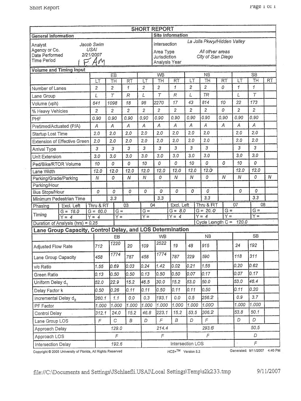
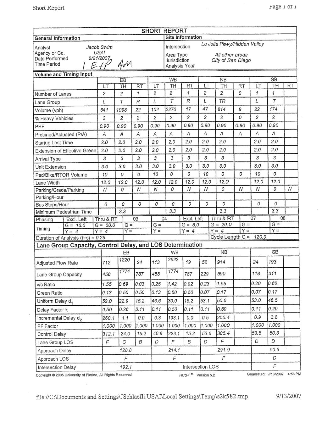
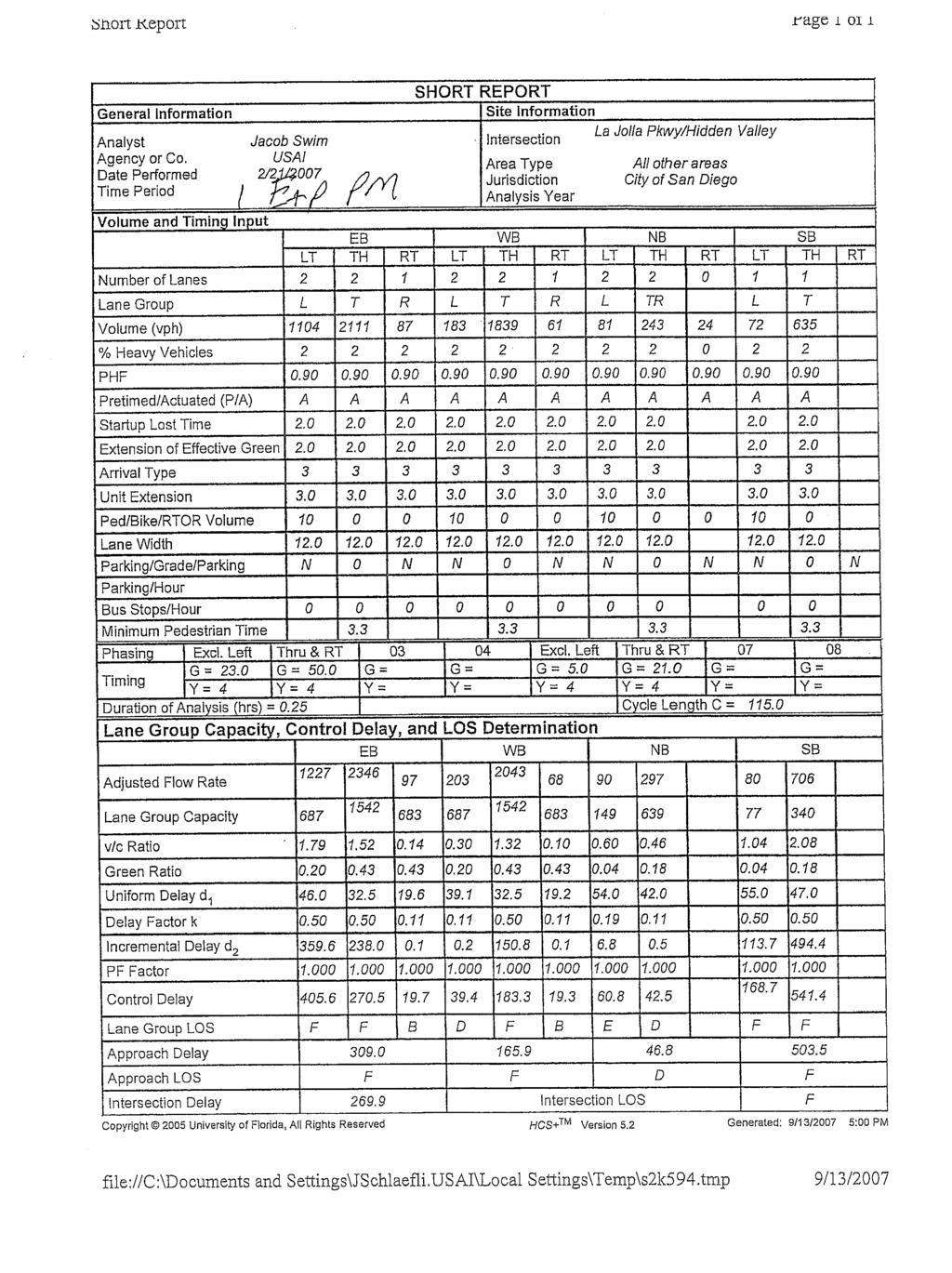
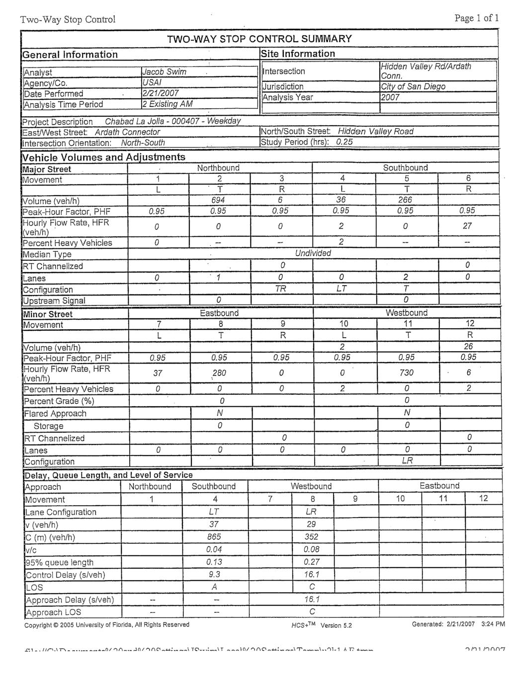
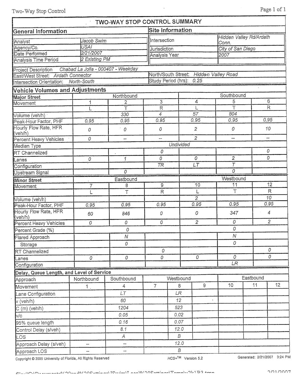
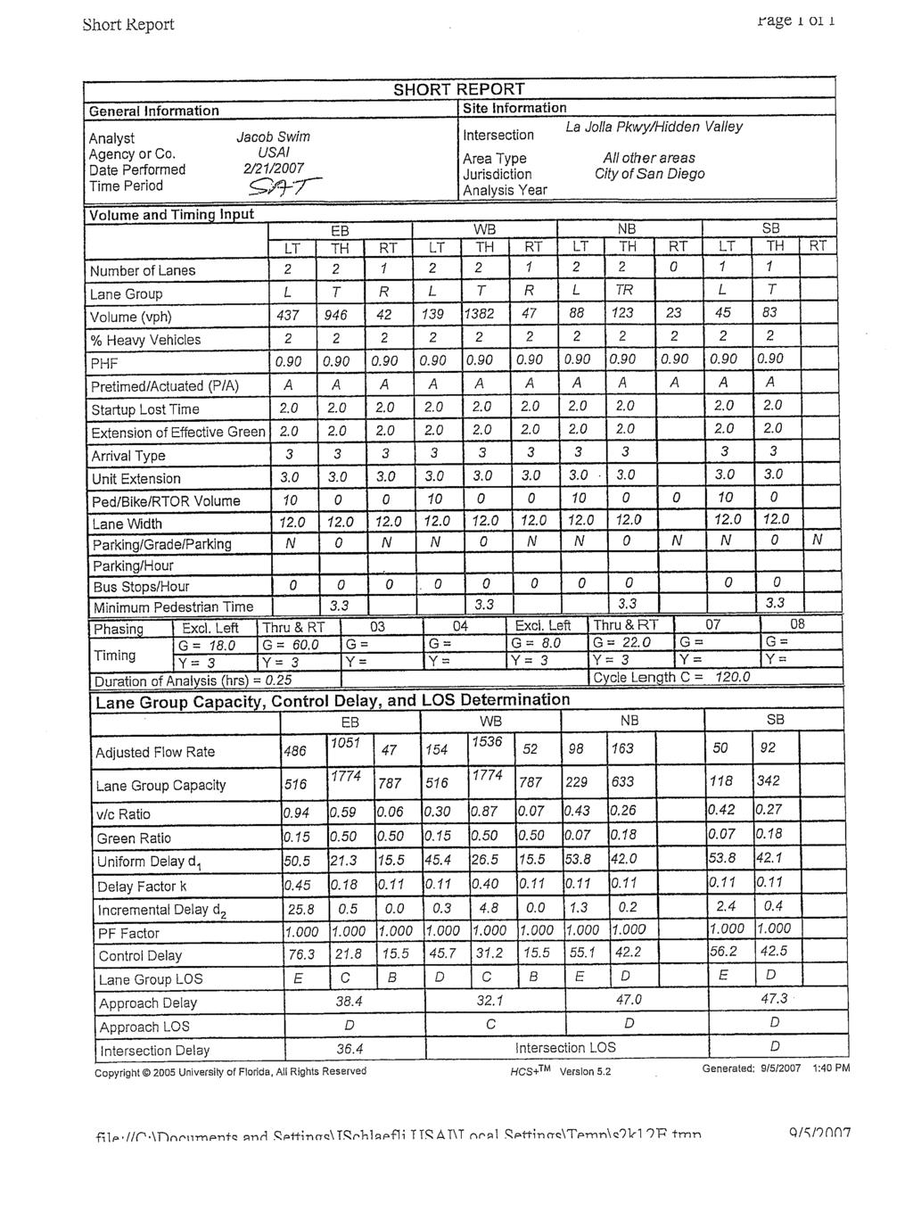
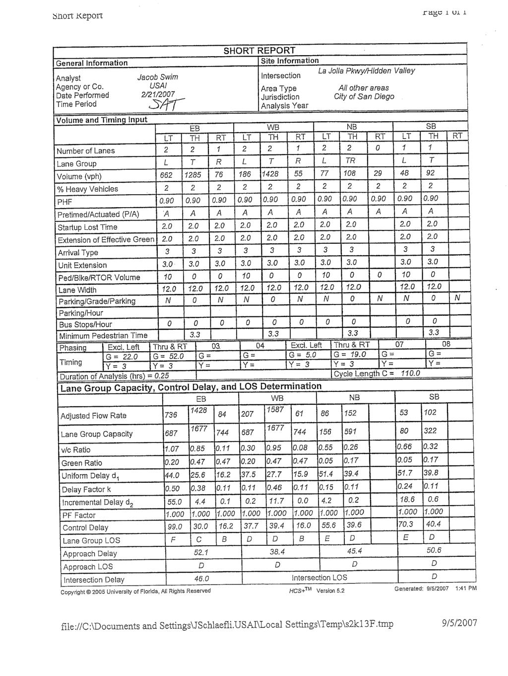
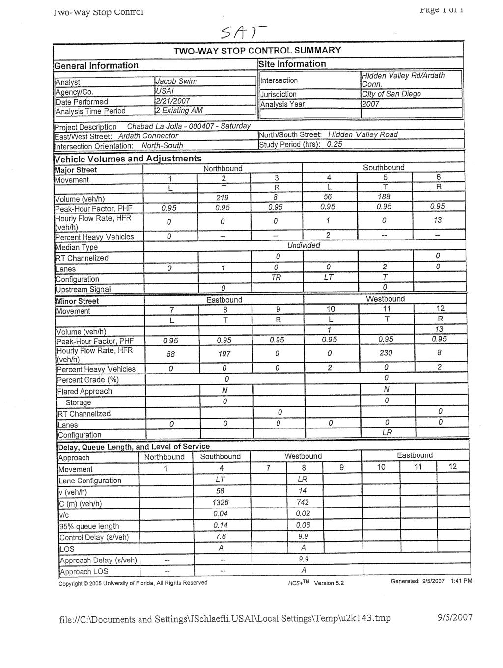
19 Chabad La Jolla Urban Systems Associates, Inc. Rabbi Baruch Ezagui May 1, ANALYSIS: TRAFFIC & PARKING 6.1 TRAFFIC First we evaluated the existing condition without the project during the week and on Saturday, the day of assembly for the proposed facility. Table 6-1 summarizes the results for two intersections adjacent to the project. As shown in the table, on a weekday during both peaks the intersection of La Jolla Parkway / Hidden Valley Road operates at a level of service F. The Hidden Valley / Ardath Connector operates at an acceptable level of service C or B during the week and A or B on the weekend. The table and analysis results clearly show that the worst case or most critical location and time for the existing condition is at the signalized intersection of La Jolla Parkway and Hidden Valley Road on a weekday Project Peak Traffic Next we determine peak project traffic at the signalized intersection so that the effect and significance of project traffic could be determined. It is important to note that this analysis was completed only for the purpose of determining if there were NO USE restrictions would the project result in significant impacts based on city criteria. Figure 6-1 shows project traffic at the intersection based on peak traffic from Table 4-1 and the distribution of traffic based on Figure 4-1. Both AM and PM traffic to and from the project is shown on Figure 6-1. This data is then used to calculate the change in delay when project traffic is added to existing traffic Report_C.doc
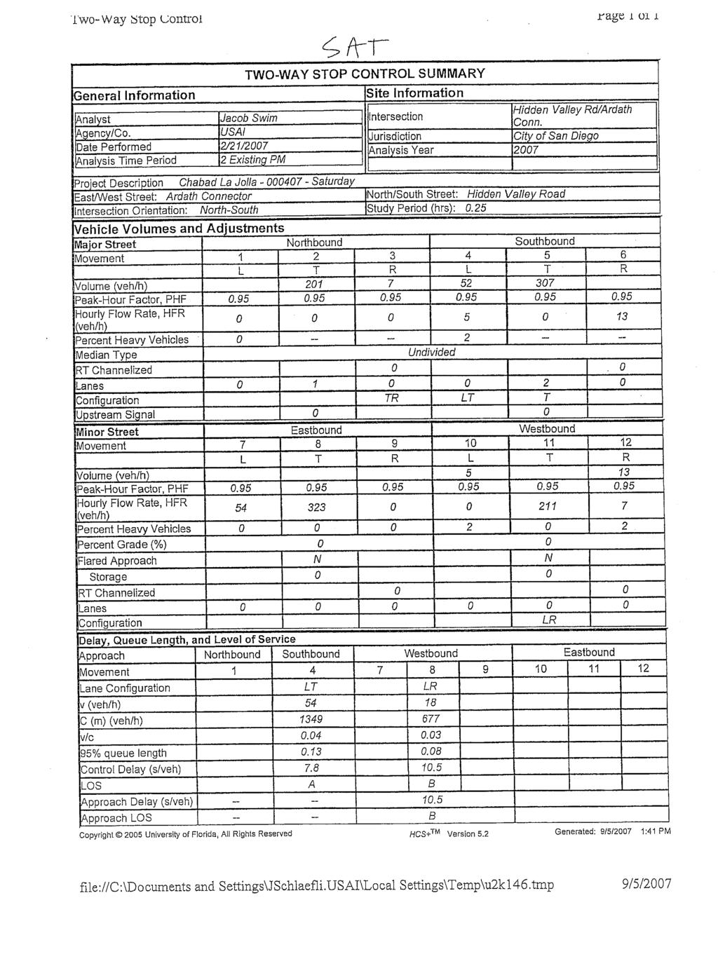
20 Chabad La Jolla Urban Systems Associates, Inc. Rabbi Baruch Ezagui May 1, 2008 TABLE 6-1 Existing Intersection LOS AM Peak Hour PM Peak Hour # Intersection Delay LOS Delay LOS Weekday 1 La Jolla Pkwy. / Hidden Valley Rd. (signalized) F F 2 Hidden Valley /Ardath Connector (unsignalized) 16.1 C 12.0 B Saturday 1 La Jolla Pkwy. / Hidden Valley Rd. (signalized) 36.4 D 46.0 D 2 Hidden Valley / Ardath Connector (unsignalized) 9.9 A 10.5 B Report_C.doc


 000407")
21 Chabad La Jolla Urban Systems Associates, Inc. Rabbi Baruch Ezagui May 1, 2008 FIGURE 6-1 AM / PM Peak Hour Project Traffic (Weekday) Report_C.doc
22 Chabad La Jolla Urban Systems Associates, Inc. Rabbi Baruch Ezagui May 1, 2008 The table below shows the change in delay when project traffic is added to existing traffic for a weekday at the signalized intersection of La Jolla Parkway and Hidden Valley / Torrey Pines Road. Change in Delay / Significance of Project Traffic Peak Change in Delay (Seconds) Criteria Significant? AM Peak = Second No PM Peak = Second No Appendix E contains the Highway Capacity Software (HCS) worksheets used in this analysis. Based on the analysis presented above which show an AM change in delay of only 1/2 second and a PM change in delay of only 1/5 second, the proposed project is not expected to have a significant traffic impact. This is because change in delay for the AM and PM peak is less than one second. As previously discussed, this analysis is included in this report for information only. The applicant has decided to voluntarily AVOID ALL WEEKDAY PEAK TRAFFIC IMPACTS by not scheduling any activities during weekday peak traffic hours. This approach avoids ALL impacts. The applicant proposes a 2 hour use restriction on weekdays for both the AM and PM peak. Figure 6-2 shows peak traffic counts for La Jolla Parkway at Hidden Valley Road. As shown in the figure, the AM peak traffic times are from 7:30 8:30. The applicant therefore proposes no use of the Sanctuary, Social Hall or Pre-school, no use means no traffic in or out during the restricted period which would be from 7-9 AM. This approach would result in no traffic impacts from the project Report_C.doc
23 Chabad La Jolla Urban Systems Associates, Inc. Rabbi Baruch Ezagui May 1, 2008 FIGURE 6-2 Peak Traffic Times Report_C.doc
24 Chabad La Jolla Urban Systems Associates, Inc. Rabbi Baruch Ezagui May 1, 2008 Based on the traffic count data, the applicant proposes restricted use from 7:00 AM to 9:00 AM i.e. ½ hour before and ½ hour after the peak one hour. During the PM peak, the traffic count data shows peak traffic times between 4:30 and 5:30. The applicant therefore proposes restricted use between the hours of 4:00 PM to 6:00 PM. 6.3 PARKING Parking for the proposed facility is provided based on City code requirements. Based on these requirements, an estimate of parking required was established. Table 6-2 shows how parking requirements were determined. As shown in Table 6-2, the maximum parking demand occurs on a weekend, Saturdays, when the sanctuary is in use. At the time the sanctuary is used outside classes for the school are not held Report_C.doc
25 Chabad La Jolla Urban Systems Associates, Inc. Rabbi Baruch Ezagui May 1, 2008 TABLE 6-2 Parking Use Rate Parking Total Residence Spaces Social Hall / or Sanctuary *96 persons 1/3 32 Spaces Pre-school NA Not used as a school during social / assembly events Office NA Not used during social or assembly events Total 36 Spaces** * Both uses are not permitted simultaneously. ** 4 are managed tandem which are assigned to either the residence or church officers Report_C.doc
26 Chabad La Jolla Urban Systems Associates, Inc. Rabbi Baruch Ezagui May 1, 2008 Essentially the pre-school is used for day care for families already attending a service. The residence was also considered in this analysis. As noted in the table, the normal residence rate of 2 per unit was doubled to account for the fact that there is no on street or driveway parking for visitors. Also it should be noted that the social hall is not considered to generate additional parking demand. This is because of the custom where a social period follows the worship service and the same people that are already present are served in the social hall. The parking demand based on City code is 36 spaces and the project proposes to build 37 spaces. Therefore the required parking is provided. There are 4 tandem spaces on the lower level of the project. Two of those spaces are reserved for the Rabbi and wife. Also two guests could use the extra two spaces for a total of 4 spaces which serve his residence. Two additional tandem spaces will be restricted for use by church officers known as Beadle, President, Cohen and Levi. One extra space is available for general use Report_C.doc
27 Chabad La Jolla Urban Systems Associates, Inc. Rabbi Baruch Ezagui May 1, CONCLUSIONS AND RECOMMENDATIONS This study was conducted for the purpose of determining what project traffic and parking impacts are most likely to occur and if those impacts are significant or would require mitigation. Based on City Traffic Impact Study Guidelines, July 1998, a traffic study for a project which generates fewer than 500 daily trips is not normally required, see Figure 7-1. However, due to community interest this study was completed. The study focused on two issues namely: 1. Traffic Impacts 2. Parking Requirements Based on this analysis we conclude that the project traffic impacts are NOT SIGNIFICANT. Therefore no further traffic analysis or mitigation is required. In addition, the project applicant is willing to restrict weekday peak hour uses so that there are NO TRAFFIC IMPACTS related to the project. Based on this analysis we also conclude that the project provides an adequate number of parking spaces for the proposed use. Also, no traffic impacts are expected due to use restrictions. We therefore recommend submittal of this analysis for City staff review and concurrence. After staff approval, we recommend that the study results be presented to the appropriate community group Report_C.doc
28 Chabad La Jolla Urban Systems Associates, Inc. Rabbi Baruch Ezagui May 1, 2008 FIGURE 7-1 Traffic Impact Study Requirement Flow Chart Report_C.doc
29 Chabad La Jolla Urban Systems Associates, Inc. Rabbi Baruch Ezagui May 1, REFERENCES City of San Diego Traffic Impact Study Manual, (July 1998) Trip Generation Manual, (May 2003) Significance Determination Thresholds, (January 2007) Parking Regulations City of San Diego San Diego Municipal Code - (Current Version) Transportation Research Board Highway Capacity Manual 2000, (2000) University of Florida Highway Capacity Software, Version 5.2 (2005) Institute of Traffic Engineers Transportation and Traffic Engineering Handbook (Current Version) Parking Generation (Current Version) Manual of Traffic Engineering Studies (4 th Edition) Urban Land Institute The Dimensions of Parking (Current Version) Shared Parking (Current Version) Report_C.doc
30 Chabad La Jolla Urban Systems Associates, Inc. Rabbi Baruch Ezagui May 1, URBAN SYSTEMS ASSOCIATES, INC. PREPARERS Principal Planning Director Sandee Witcraft-Schlaefli; J.D. Juris Doctor, Graduate Courses Urban Planning, B.A. Political Science/Social Welfare Principal Engineer Andrew P. Schlaefli; M.S. Civil Engineering, B.S. Civil Engineering Registered Civil Engineer, Licensed Traffic Engineer Senior Technical Support, Graphics and Illustrations Mark A. Schlaefli Word Processing, Report Production and Compilation Dannielle B. Glodowski This report is site and time specific and is intended for a one-time use for this intended project under the conditions described as Proposed Project. Any changes or delay in implementation may require re-analysis and re-consideration by the public agency granting approvals. California land development planning involves subjective political considerations as well as frequently re-interpreted principals of law as well as changes in regulations, policies, guidelines and procedures. Urban Systems and their professionals make no warrant, either express or implied, regarding our findings, recommendations, or professional advice as to the ability to successfully accomplish this land development project. Traffic is a consequence of human behavior and as such is predictable only in a gross cumulative methodology of user opportunities, using accepted standards and following patterns of past behavior and physical constraints attempting to project into a future window of circumstances. Any counts or existing conditions cited are only as reliable as to the time and conditions under which they were recorded. As such the preparer of this analysis is unable to warrant, either express or implied, that any forecasts are statements of actual true conditions which will in fact exist at any future date. Services performed by Urban Systems professionals resulting in this document are of a manner consistent with that level of care and skill ordinarily exercised by members of the profession currently practicing in the same locality under similar conditions. No other representation expressed or implied and no warranty or guarantee is included or intended in this report, document opinion or otherwise. Any changes by others to this analysis or re-use of document at a later point in time or other location, without the express consent and concurrence of Urban Systems releases and relieves Urban Systems of any liability, responsibility or duty for subsequent questions, claims, or damages Report_C.doc
31
32
33
34
35
36
37
38
39
40
41
42
43
44
45
46
47
48
49
50
51
52
53
54
55
56
57
58
59
60
61
62
63

64
65
66
67
68
69
70
71
72
Magnolia Place. Traffic Impact Analysis. Prepared for: City of San Mateo. Prepared by: Hexagon Transportation Consultants, Inc.
 Magnolia Place Traffic Impact Analysis Prepared for: City of San Mateo Prepared by: Hexagon Transportation Consultants, Inc. Updated January 4, 2010 Table of Contents 1. Introduction...1 2. Existing Conditions...6
Traffic Impact Study. Westlake Elementary School Westlake, Ohio. TMS Engineers, Inc. June 5, 2017
 TMS Engineers, Inc. Traffic Impact Study Westlake Elementary School Westlake, Ohio June 5, 2017 Prepared for: Westlake City Schools - Board of Education 27200 Hilliard Boulevard Westlake, OH 44145 TRAFFIC
TRAFFIC IMPACT STUDY And A TRAFFIC SIGNAL WARRANT ANALYSIS FOR A SENIOR LIVING AND APARTMENT DEVELOPMENT
 TRAFFIC IMPACT STUDY And A TRAFFIC SIGNAL WARRANT ANALYSIS FOR A SENIOR LIVING AND APARTMENT DEVELOPMENT DEERFIELD TOWNSHIP, WARREN COUNTY, OHIO Nantucket Circle and Montgomery Road () Prepared for: ODLE
TRAFFIC STUDY GUIDELINES Clarksville Street Department
 TRAFFIC STUDY GUIDELINES Clarksville Street Department 9/1/2009 Introduction Traffic studies are used to help the city determine potential impacts to the operation of the surrounding roadway network. Two
List of Attachments. Location Map... Site Plan... City of Lake Elsinore Circulation Element... City of Lake Elsinore Roadway Cross-Sections...
 List of Attachments Exhibits Location Map... Site Plan... City of Lake Elsinore Circulation Element... City of Lake Elsinore Roadway Cross-Sections... Existing Lane Geometry and Traffic Controls... Existing
Traffic Impact Statement
 Traffic Impact Statement Mixed Use Development, US 41 and Old Trail Drive aka Tide-Starbucks 4900 9 th Street North General Development Site Plan (GDSP) Collier County, FL 10/6/2015 Prepared for: Prepared
Transportation Impact Study for Abington Terrace
 Transportation Impact Study for Abington Terrace Abington Township, Montgomery County, PA Sandy A. Koza, P.E., PTOE PA PE License Number PE059911 Prepared by McMahon Associates, Inc. 425 Commerce Drive,
THIS PAGE LEFT BLANK INTENTIONALLY
 GA SR 25 Spur at Canal Road Transportation Impact Analysis PREPARED FOR GLYNN COUNTY, GEORGIA 1725 Reynolds Street, Suite 300 Brunswick, Georgia 31520 PREPARED BY 217 Arrowhead Boulevard Suite 26 Jonesboro,
Traffic Impact Analysis Walton Acres at Riverwood Athletic Club Clayton, NC
 Traffic Impact Analysis Walton Acres at Riverwood Athletic Club Clayton, NC 1. TABLE OF CONTENTS INTRODUCTION...1 1.1. Site Location and Study Area...1 1.2. Proposed Land Use and Site Access...2 1.3.
TRAFFIC IMPACT STUDY CRITERIA
 Chapter 6 - TRAFFIC IMPACT STUDY CRITERIA 6.1 GENERAL PROVISIONS 6.1.1. Purpose: The purpose of this document is to outline a standard format for preparing a traffic impact study in the City of Steamboat
USA Parkway Traffic Operations Analysis, Roundabout Option. Pedro Rodriguez, NDOT; Bryan Gant, Jacobs; Randy Travis, NDOT
 Technical Memorandum TO: Hoang Hong, NDOT DATE: September 21, 2012 FROM: SUBJECT: COPIES: John Karachepone, Jacobs USA Parkway Traffic Operations Analysis, Pedro Rodriguez, NDOT; Bryan Gant, Jacobs; Randy
Appendix H. Traffic Analysis
 Appendix H Traffic Analysis Allyn D. Rifkin PE Los Feliz Towers E-mail allynrifkin@gmail.com 4455 Los Feliz Boulevard Suite 1403 Telephone and fax -- (323) 664-2805 Los Angeles, CA 90027 Mobile phone (323)
EXECUTIVE SUMMARY. Page 1 of 6
 EXECUTIVE SUMMARY The purpose of this report is to identify conformance with the original traffic impact study for the proposed retail development on Lot 5 of Riverdale Retail Filing No. 1 located on the
Traffic Impact Analysis Chatham County Grocery Chatham County, NC
 Chatham County Grocery Chatham County, NC TABLE OF CONTENTS 1. INTRODUCTION... 1 1.1. Location and Study Area... 1 1.2. Proposed Land Use and Access... 2 1.3. Adjacent Land Uses... 2 1.4. Existing ways...
TRANSPORTATION ANALYSIS REPORT US Route 6 Huron, Erie County, Ohio
 TRANSPORTATION ANALYSIS REPORT US Route 6 Huron, Erie County, Ohio December 12, 2012 Prepared for: The City of Huron 417 Main Huron, OH 44839 Providing Practical Experience Technical Excellence and Client
 TRAFFIC IMPACT STUDY CANYON HILLS PROJECT LOS ANGELES, CALIFORNIA INTRODUCTION This traffic analysis has been conducted to identify and evaluate the potential traffic impacts of the proposed Canyon Hills
TABLE OF CONTENTS TABLE OF CONTENTS... I APPENDICES... III LIST OF EXHIBITS... V LIST OF TABLES... VII LIST OF ABBREVIATED TERMS...
 TABLE OF CONTENTS TABLE OF CONTENTS... I APPENDICES... III LIST OF EXHIBITS... V LIST OF TABLES... VII LIST OF ABBREVIATED TERMS... IX 1 INTRODUCTION... 1 1.1 Project Overview... 1 1.2 Analysis Scenarios...
TRAFFIC IMPACT STUDY. Creekside Thornton, Colorado. For. August 2015 November 2015 Revised: August Prepared for:
 TRAFFIC IMPACT STUDY For Creekside Thornton, Colorado August 215 November 215 Revised: August 216 Prepared for: Jansen Strawn Consulting Engineers 45 West 2 nd Avenue Denver, Colorado 8223 Prepared by:
Los Coyotes Country Club Development Plan Traffic Impact Analysis
 Los Coyotes Country Club Development Plan Traffic Impact Analysis Prepared For: Phil Martin Associates 2073007450 Los Coyotes Country Club Development Plan Traffic Impact Analysis June 19, 2014 Prepared
Highway 111 Corridor Study
 Highway 111 Corridor Study June, 2009 LINCOLN CO. HWY 111 CORRIDOR STUDY Draft Study Tea, South Dakota Prepared for City of Tea Sioux Falls Metropolitan Planning Organization Prepared by HDR Engineering,
Traffic Impact Analysis (TIA) Process and Procedures Manual. September 2017
 Process and Procedures Manual. September 2017") Traffic Impact Analysis (TIA) Process and Procedures Manual Post Office Box 664 101 Huntersville-Concord Road Huntersville, NC 28070 Phone 704-766-2220 Fax 704-992-5528 www.huntersville.org (c) 2017, Town
Traffic Impact Analysis (TIA) Process and Procedures Manual Post Office Box 664 101 Huntersville-Concord Road Huntersville, NC 28070 Phone 704-766-2220 Fax 704-992-5528 www.huntersville.org (c) 2017, Town
Shockoe Bottom Preliminary Traffic and Parking Analysis
 Shockoe Bottom Preliminary Traffic and Parking Analysis Richmond, Virginia August 14, 2013 Prepared For City of Richmond Department of Public Works Prepared By 1001 Boulders Pkwy Suite 300, Richmond, VA
A Traffic Operations Method for Assessing Automobile and Bicycle Shared Roadways
 A Traffic Operations Method for Assessing Automobile and Bicycle Shared Roadways A Thesis Proposal By James A. Robertson Submitted to the Office of Graduate Studies Texas A&M University in partial fulfillment
Technical Memorandum TRAFFIC IMPACT STUDY. RIDLEY ROAD CONVENIENCE STORE Southampton County, VA. Prepared for: Mr. David Williams.
 Technical Memorandum TRFFIC IMPCT STUDY RIDLEY ROD CONVENIENCE STORE Southampton County, V Prepared for: Mr. David Williams By: Charles Smith, P.E., PTOE EPR Charlottesville, V July 2014 1 TBLE OF CONTENTS
CarMax Auto Superstore/ Reconditioning Center #6002 Murrieta, California
 CarMax Auto Superstore/ Reconditioning Center #6002 Murrieta, California TUSTIN 17782 17th Street Suite 200 Tustin, CA 92780-1947 714.665.4500 Fax: 714.665.4501 LOS ANGELES 145 S. Spring Street Suite 120
Glenn Avenue Corridor Traffic Operational Evaluation
 Glenn Avenue Corridor Traffic Operational Evaluation PREPARED FOR: THE CITY OF AUBURN PREPARED BY: DECEMBER 2007 Glenn Avenue Corridor Study--Auburn, Alabama TABLE OF CONTENTS Introduction... 1 Background
9 Leeming Drive Redevelopment Ottawa, ON Transportation Brief. Prepared By: Stantec Consulting Ltd.
 9 Leeming Drive Redevelopment Ottawa, ON Transportation Brief Prepared By: Stantec Consulting Ltd. TIA GUIDELINES CHECKLIST Report Context Municipal Address Comment: Section 1.1 Location relative to major
3.9 - Transportation and Traffic
 Transportation and Traffic 3.9 - Transportation and Traffic This section describes the potential transportation and traffic effects of project implementation on the project site and its surrounding area.
The proposed development is located within 800m of an existing Transit Station where infill developments and intensification are encouraged.
 Stantec Consulting Ltd. 1331 Clyde Avenue, Suite 4 Ottawa ON K2C 3G4 Tel: (613) 722-442 Fax: (613) 722-2799 May 14, 213 File: 1638823 Robinson Park Development Corp. 5699 Power Road Ottawa, ON, K1G 3N4
Project Report. South Kirkwood Road Traffic Study. Meadows Place, TX October 9, 2015
 Meadows Place, TX October 9, 2015 Contents 1 Introduction... 1 2 Data Collection... 1 3 Existing Roadway Network... 2 4 Traffic Volume Development... 2 5 Warrant Analysis... 3 6 Traffic Control Alternative
4.0 TRAFFIC IMPACT STUDIES
 SECTION 4 4.0 TRAFFIC IMPACT STUDIES 4.1 TRAFFIC IMPACT STUDY REQUIREMENTS The City has established Traffic Impact Study (TIS) requirements for the purpose of ensuring that both the quantitative and qualitative
CHAPTER 4 TRANSPORTATION IMPACT STUDY TABLE OF CONTENTS
 CHAPTER 4 TRANSPORTATION IMPACT STUDY TABLE OF CONTENTS Section Title Page 4.1 Introduction... 4-1 4.1.1 General... 4-1 4.1.2 Applicant Responsibility... 4-1 4.1.3 Capacity and Safety Issues... 4-1 A.
APPENDIX F SUPPLEMENTAL TRAFFIC DATA
 APPENDIX F SUPPLEMENTAL TRAFFIC DATA Environmental and Planning Consultants 440 Park Avenue South 7th Floor New York, NY 10016 tel: 212 696-0670 fax: 212 213-3191 www.akrf.com Draft Memorandum To: Michael
6060 North Central Expressway Mixed-Use Site Dallas, Texas
 Volume 1 Traffic Impact Analysis 6060 North Central Expressway Mixed-Use Site Dallas, Texas April 30, 2018 Kimley-Horn and Associates, Inc. Dallas, Texas Project #063238300 Registered Firm F-928 Traffic
TRAFFIC ASSESSMENT River Edge Colorado
 TRAFFIC ASSESSMENT River Edge Colorado Submitted by: Fehr & Peers 621 17th Street, Ste. 231 Denver, CO 8293 (33) 296-43 December, 21 App. M-2 Traffic Assessment River Edge Colorado December 21 TABLE OF
TRAFFIC IMPACT STUDY COMPREHENSIVE UPDATE TOWN OF THOMPSON S STATION, TENNESSEE PREPARED FOR: THE TOWN OF THOMPSON S STATION
 TRAFFIC IMPACT STUDY COMPREHENSIVE UPDATE TOWN OF THOMPSON S STATION, TENNESSEE PREPARED FOR: THE TOWN OF THOMPSON S STATION Transportation Consultants, LLC 1101 17 TH AVENUE SOUTH NASHVILLE, TN 37212
ALLEY 24 TRAFFIC STUDY
 ALLEY 24 TRAFFIC STUDY in City of Frostburg, Maryland January 2013 3566 Teays Valley Road Hurricane, WV Office: (304) 397-5508 www.denniscorporation.com Alley 24 Traffic Study January 2013 Frostburg, Maryland
Truck Climbing Lane Traffic Justification Report
 ROUTE 7 (HARRY BYRD HIGHWAY) WESTBOUND FROM WEST MARKET STREET TO ROUTE 9 (CHARLES TOWN PIKE) Truck Climbing Lane Traffic Justification Report Project No. 6007-053-133, P 101 Ι UPC No. 58599 Prepared by:
D.13 Transportation and Traffic
 This section addresses transportation and traffic issues and impacts related to the Proposed Project. Section D.13.1 provides a description of the affected environment for the Proposed Project. Applicable
EAST AND SOUTH STREET CITY OF ANAHEIM, CALIFORNIA
 T R A F F I C I M P A C T A N A LY S I S EAST AND SOUTH STREET CITY OF ANAHEIM, CALIFORNIA April 217 T R A F F I C I M P A C T A N A LY S I S EAST AND SOUTH STREET CITY OF ANAHEIM, CALIFORNIA Submitted
5.3 TRAFFIC, CIRCULATION AND PARKING
 5.3 TRAFFIC, CIRCULATION AND PARKING This section is based upon the Downtown Lancaster Specific Plan Traffic Impact Analysis (April 2, 2008) and the Downtown Lancaster Specific Plan Parking Analysis (May
HENDERSON DEVELOPMENT 213, 217, 221, 221 ½, 223 HENDERSON AVENUE and 65 TEMPLETON STREET OTTAWA, ONTARIO TRANSPORTATION OVERVIEW.
 HENDERSON DEVELOPMENT 213, 217, 221, 221 ½, 223 HENDERSON AVENUE and 65 TEMPLETON STREET OTTAWA, ONTARIO TRANSPORTATION OVERVIEW Prepared for: 2294170 Ontario Inc. February 2, 2017 117-652 Report_1.doc
TRAFFIC IMPACT ANALYSIS
 TRAFFIC IMPACT ANALYSIS FOR THE CHAMPAIGN UNIT#4 SCHOOL DISTRICT PROPOSED HIGH SCHOOL (SPALDING PARK SITE) IN THE CITY OF CHAMPAIGN Final Report Champaign Urbana Urbanized Area Transportation Study 6/24/2014
King Soopers #116 Thornton, Colorado
 Traffic Impact Study King Soopers #116 Thornton, Colorado Prepared for: Galloway & Company, Inc. 1.0 EXECUTIVE SUMMARY King Soopers #116, a grocery marketplace anchored commercial development, is proposed
TRAFFIC IMPACT ANALYSIS OF PROPOSED CHESTNUT HILL COLLEGE MASTER PLAN DEVELOPMENT
 TRAFFIC IMPACT ANALYSIS OF PROPOSED CHESTNUT HILL COLLEGE MASTER PLAN DEVELOPMENT Prepared by Orth-Rodgers & Associates, Inc. December 14, 2009 Updated November 9, 2010 230 South Broad Street Philadelphia
5858 N COLLEGE, LLC N College Avenue Traffic Impact Study
 5858 N COLLEGE, LLC nue Traffic Impact Study August 22, 2016 Contents Traffic Impact Study Page Preparer Qualifications... 1 Introduction... 2 Existing Roadway Conditions... 5 Existing Traffic Conditions...
Walmart (Store # ) 60 th Street North and Marion Road Sioux Falls, South Dakota
 60 th Street North and Marion Road Sioux Falls, South Dakota") Walmart (Store #4865-00) 60 th Street North and Marion Road Sioux Falls, South Dakota Prepared for: Wal-Mart Stores, Inc. Bentonville, Arkansas Prepared by: Kimley-Horn and Associates, Inc. ã2013 Kimley-Horn
Walmart (Store #4865-00) 60 th Street North and Marion Road Sioux Falls, South Dakota Prepared for: Wal-Mart Stores, Inc. Bentonville, Arkansas Prepared by: Kimley-Horn and Associates, Inc. ã2013 Kimley-Horn
Troutbeck Farm Development
 Troutbeck Farm Development Willistown Township, Chester County PA For Submission To: Willistown Township Last Revised: October, 4 TPD# INLM.A. 5 E. High Street Suite 65 Pottstown, PA 9464 6.36.3 TPD@TrafficPD.com
Borough of Danville, PA Traffic Calming Program Guidelines
 Borough of Danville, PA Traffic Calming Program Guidelines Adopted by Borough Council on 1 INTRODUCTION Speeding Traffic is a major concern in the Borough of Danville because of its detrimental impacts
2016 Church Street Access Study. 100 Clinton Square 126 North Salina Street, Suite 100 Syracuse, NY
 2016 Church Street Access Study 100 Clinton Square 126 North Salina Street, Suite 100 Syracuse, NY 13202 www.smtcmpo.org Syracuse Metropolitan Transportation Council Final Report February 23, 2016 This
City of Homewood Transportation Plan
 City of Homewood Transportation Plan Prepared for: City of Homewood, Alabama Prepared by: Skipper Consulting, Inc. May 2007 TABLE OF CONTENTS INTRODUCTION... 1 BACKGROUND INFORMATION... 1 EXISTING TRANSPORTATION
Prescott Plaza TRAFFIC IMPACT ANALYSIS TOWN OF YUCCA VALLEY
 Prescott Plaza TRAFFIC IMPACT ANALYSIS TOWN OF YUCCA VALLEY PREPARED BY: Aric Evatt, PTP aevatt@urbanxroads.com (949) 660-1994 x204 Charlene So, PE cso@urbanxroads.com (949) 660-1994 x222 OCTOBER 18, 2018
TRAFFIC IMPACT STUDY
 TRAFFIC IMPACT STUDY for the GLEN ELLEN COUNTRY CLUB SENIOR RESIDENTIAL REDEVELOPMENT 84 Millis, Massachusetts Prepared by: McMahon Associates, Inc. Prepared for: Toll Brothers, Inc. August 216 DRAFT
Operational Ranking of Intersections: A Novel Prioritization Methodology
 Operational Ranking of Intersections: A Novel Prioritization Methodology Reza Omrani, Ph.D. Transportation Engineer CIMA+ 3027 Harvester Road, Suite 400 Burlington, ON L7N 3G7 Reza.Omrani@cima.ca Pedram
FINAL Albertville Business Park AUAR Update Traffic Study
 FINAL Albertville Business Park AUAR Update Traffic Study Prepared for City of Albertville, MN July 20, 2017 SRF No. 10060.00 Table of Contents Introduction... 1 Existing Conditions... 1 Data Collection...
Donahue Drive Corridor Traffic Operational Evaluation
 Donahue Drive Corridor Traffic Operational Evaluation PREPARED FOR: THE CITY OF AUBURN PREPARED BY: JANUARY 2007 Donahue Drive Corridor Study--Auburn, Alabama TABLE OF CONTENTS Introduction... 1 Background
Overland Traffic Consultants, Inc. October 15, Mr. Bruce McBride Project Delivery Analysts, LLC Shawnee Street Moorpark, CA 93021
 Overland Traffic Consultants 952 Manhattan Beach Boulevard, Suite #100 Manhattan Beach, CA 90266 Phone (661) 799-8423 E-mail: otc@overlandtraffic.com October 15, 2015 Mr. Bruce McBride Project Delivery
SELECTED ROADWAY CAPACITY ANALYSIS
 CHAPTERFOUR SELECTED ROADWAY CAPACITY ANALYSIS 4.1 SELECTED ROADWAY CAPACITY ANALYSIS Introduction Capacity analysis was performed on six selected roadways within the Dearborn County study area using the
THE LANDMARK AT TALBOT PARK
 TRAFFIC IMPACT STUDY FOR THE LANDMARK AT TALBOT PARK IN NORFOLK, VA INTERMODAL ENGINEERING, P.C. OCTOBER, 200 The Landmark at Talbot Park is a proposed redevelopment of the existing apartments along the
FORM A PASCO COUNTY ACCESS CONNECTION PERMIT APPLICATION
 FORM 901.3.A PASCO COUNTY ACCESS CONNECTION PERMIT APPLICATION The following information is required from all applicants directly or indirectly accessing any collector or arterial road or as otherwise
TRAFFIC CALMING POLICY NEWTOWN TOWNSHIP DELAWARE COUNTY, PA
 TRAFFIC CALMING POLICY NEWTOWN TOWNSHIP DELAWARE COUNTY, PA September 2014 1 TABLE OF CONTENTS INTRODUCTION... 3 PURPOSE AND GOALS... 3 DEFINITIONS... 4 APPLICABILITY... 5 ELIGIBLE STREETS... 5 LOCATION
Traffic Impact Analysis
 Traffic Impact Analysis Isle of Capri Casinos, Inc. Waterloo, Iowa SEH No. A-CLAAS0501.00 November 16, 2004 Table of Contents (Continued) Table of Contents Certification Page Table of Contents Page 1.0
Waterford Lakes Small Area Study
 Waterford Lakes Small Area Study Existing Traffic Conditions PREPARED FOR: ORANGE COUNTY PUBLIC WORKS DEPARTMENT TRAFFIC ENGINEERING DIVISION ORLANDO, FLORIDA PREPARED WITH: INWOOD CONSULTING ENGINEERS
Traffic Impact Analysis
 Traffic Impact Analysis TRAFFIC IMPACT ANALYSIS FOR A PROPOSED NEIGHBORHOOD SHOPPING CENTER Civic Center Way and Cross Creek Road City of Malibu Prepared for: Goldman Firth Rossi Architects Prepared by:
TRAFFIC MANAGEMENT PLAN
 May 4, 018 PK# 415-17.387 Z 178-150 TRAFFIC MANAGEMENT PLAN Project: In Dallas, Texas Prepared for: City of Dallas On behalf of: Dallas Independent School District Prepared by: Hunter W. Lemley, P.E. 7557
Turn Lane Warrants: Concepts, Standards, Application in Review
 Turn Lane Warrants: Concepts, Standards, Application in Review David J. DeBaie P.E., P.T.O.E. 2004 ITE, District 1 Annual Meeting Burlington, Vermont Introduction Turning lanes at intersections reduce
TABLE TRAFFIC ANALYSIS SCENARIOS
 4.11 TRANSPORTATION The potential traffic impacts of the proposed project are evaluated in the Buena Park Beach/Orangethorpe Mixed Use Project Traffic Analysis (Traffic Analysis) by Austin-Foust Associates
Traffic Impact Study WestBranch Residential Development Davidson, NC March 2016
 Traffic Impact Study WestBranch Residential Development Davidson, NC March 216 TRAFFIC IMPACT STUDY FOR THE WestBranch Residential Development LOCATED IN DAVIDSON, NC Prepared For: Lennar Carolinas, LLC
MEMORANDUM. To: 1.0 PURPOSE
 MEMORANDUM To: Scott Holland, Elements Architecture From: Brian Grover, Dudek Date: July 16, 2014 1.0 PURPOSE In response to the November 4, 2013 request (RE: Incomplete Application Southern California
South Albion-Bolton Community Plan North Hill Supermarket Transportation Study Part B: Evaluation of Alternatives
 Community Plan North Hill Supermarket Transportation Study Part B: Evaluation of Alternatives Prepared for: The Town of Caledon August 9 Transportation Solutions Ltd. 43 Forest Road Cambridge, ON N1S 3B4
VIVA RETIREMENT COMMUNITIES OAKVILLE TRAFFIC IMPACT STUDY
 VIVA RETIREMENT COMMUNITIES OAKVILLE TRAFFIC IMPACT STUDY VIVA RETIREMENT COMMUNITIES OAKVILLE TRAFFIC IMPACT STUDY DECEMBER 2012 READ, VOORHEES & ASSOCIATES TORONTO, ONTARIO Read, Voorhees & Associates
Table of Contents FIGURES TABLES APPENDICES. Traffic Impact Study Hudson Street Parking Garage MC Project No.: A Table of Contents
 Traffic Impact Study Hudson Street Parking Garage MC Project No.: 151714A Table of Contents Table of Contents I. INTRODUCTION... 2 II. EXISTING CONDITIONS... 5 III. 215 EXISTING TRAFFIC CONDITIONS... 6
Road Conversion Study Plumas Street
 Plumas Street Phase I Submitted to The Regional Transportation Commission of Washoe County Submitted by Zong Tian, Ph.D., P.E. Saeedeh Farivar Haiyuan Li, Ph.D. Center for Advanced Transportation Education
INDUSTRIAL BUILDING 3009 HAWTHORNE ROAD CITY OF OTTAWA TRANSPORTATION OVERVIEW REVISED. Prepared for: Canada Inc.
 INDUSTRIAL BUILDING 3009 HAWTHORNE ROAD CITY OF OTTAWA TRANSPORTATION OVERVIEW REVISED Prepared for: 7849648 Canada Inc. Octiober 1, 2015 114-598 Overview_2.doc D. J. Halpenny & Associates Ltd. Consulting
May 5, 2009 File:
 MMM Group Limited Suite 600 1455 West Georgia Street Vancouver, BC V6G 2T3 t: 604-685-9381 f: 604-683-8655 www.mmm.ca May 5, 2009 File: 50-09001-007 1420 1055 West Hastings Street Vancouver, BC V6E 2E9
Mission Street Medical Office Development
 reet Medical Office Development Traffic Impact Analysis Prepared for: Palo Alto Medical Foundation February 23, 2012 Hexagon Office: 7888 Wren Avenue, Suite B121 Gilroy, CA 95020 Hexagon Job Number: 11RD11
TRAFFIC MANAGEMENT PLAN
 April 19, 018 PK# 415-17.387 TRAFFIC MANAGEMENT PLAN Project: In Dallas, Texas Prepared for: City of Dallas On behalf of: Dallas Independent School District Prepared by: Hunter W. Lemley, P.E. 7557 Rambler
COMMERCIAL DEVELOPMENT 2015 ROBERTSON ROAD OTTAWA, ONTARIO TRANSPORTATION BRIEF. Prepared for:
 COMMERCIAL DEVELOPMENT 2015 ROBERTSON ROAD OTTAWA, ONTARIO TRANSPORTATION BRIEF Prepared for: First Bay Properties Inc. 311 Richmond Road, Suite 203 Ottawa, ON K1Z 6X3 August 8, 2017 117-663 Brief_1.doc
Clackamas County Comprehensive Plan
 ROADWAYS The County s road system permits the movement of goods and people between communities and regions, using any of a variety of modes of travel. Roads provide access to virtually all property. They
Traffic Impact Study Little Egypt Road Development Denver, North Carolina June 2017
 Traffic Impact Study Little Egypt Road Development Denver, North arolina June 2017 N. Little Egypt Road DQ\ QDQFLQJ VDOHV RU RWKHU SHUIRUPDQFH EDVHG FULWHULD Proposed Site Driveways Site Driveway 1 TRAFFI
FRONT RANGE CROSSINGS TRAFFIC IMPACT STUDY
 FRONT RANGE CROSSINGS TRAFFIC IMPACT STUDY Prepared for: City of Thornton And Colorado Department of Transportation Prepared by: 11 Blake Street, Suite 2 Denver, Colorado 822 Contact: Brian Bern, PE, PTOE
Traffic Impact Study. Roderick Place Columbia Pike Thompson s Station, TN. Transportation Group, LLC Traffic Engineering and Planning
 F i s c h b a c h Transportation Group, LLC Traffic Engineering and Planning Traffic Impact Study Roderick Place Columbia Pike Thompson s Station, TN Prepared March 2016 Ms. Gillian L. Fischbach, P.E.,
P HA Transportation Consultants
 Attachment F P HA Transportation Consultants 2711 Stuart Street Berkeley CA 94705 Phone {510) 848-92.33 Web www.pangho.com September 8, 2017 Newell Arnerich AD Architects Via email:newell@adarch.com Dear
DRAFT TRAFFIC STUDY BOULDER AVENUE BRIDGE REPLACEMENT CITY OF HIGHLAND SAN BERNARDINO COUNTY, CALIFORNIA
 DRAFT CITY OF HIGHLAND SAN BERNARDINO COUNTY, CALIFORNIA August 8, 2006 DRAFT CITY OF HIGHLAND SAN BERNARDINO COUNTY, CALIFORNIA Prepared for: City of Highland 27215 Baseline Highland, California 92346
PEER REVIEW. This letter is to provide a peer review to the City of Leavenworth for the Leavenworth Adventure Park TIA dated October 2018.
 PEER REVIEW To: City of Leavenworth Staff From: Brad Lincoln, P.E. Subject: Project: Leavenworth Adventure Park GTC #18-292 Date: October 24, 2018 This letter is to provide a peer review to the City of
APPENDIX H EXISTING TRAFFIC CONDITIONS ANALYSIS
 APPENDIX H EXISTING TRAFFIC CONDITIONS ANALYSIS MEMO : Peter Steacy, P.Eng. Date: December 3, 2014 : Ian Borsuk, P.Eng. Job No.: 3414015-000 Subject: City of Ottawa O-Train Extension Planning & EA Study
4.4 TRAFFIC and CIRCULATION
 4.4 TRAFFIC and CIRCULATION This section analyzes potential impacts relating to traffic and circulation. The section summarizes the findings of a traffic impact study performed by Associated Transportation
Table of Contents. I. Introduction 1. II. Elements of the School Crossing Program 1
 Table of Contents Page I. Introduction 1 II. Elements of the School Crossing Program 1 a. Identifying Locations Where School Crossing Guards are Needed 1 b. The Role of the School Crossing Guard 1 c. Hiring
Traffic Assessment for Woodhaven Redevelopment. City of Rome Oneida County, New York. March 2, 2018
 March 2, 2018 Traffic Assessment for Woodhaven Redevelopment City of Rome Oneida County, New York Prepared for: City of Rome 198 N. Washington Street Rome, NY 13440 Prepared by: C.T. MALE ASSOCIATES 50
4. ENVIRONMENTAL IMPACT ANALYSIS 9. TRANSPORTATION AND TRAFFIC
 4. ENVIRONMENTAL IMPACT ANALYSIS 9. TRANSPORTATION AND TRAFFIC 4.9.1 INTRODUCTION The following section addresses the Proposed Project s impact on transportation and traffic based on the Traffic Study
TEMPORARY TRAFFIC CONTROL GUIDELINES FOR HIGHWAY-RAIL GRADE CROSSINGS
 TEMPORARY TRAFFIC CONTROL GUIDELINES FOR HIGHWAY-RAIL GRADE CROSSINGS 1.0 INTRODUCTION 1.1 Purpose The Southern California Regional Rail Authority (SCRRA) is the designated track owner of the Metrolink
Bistro 6. City of Barrie. Traffic Impact Study for Pratt Hansen Group Inc. Type of Document: Final Report. Project Number: JDE 1748
 City of Barrie Traffic Impact Study for Pratt Hansen Group Inc. Type of Document: Final Report Project Number: JDE 1748 Date Submitted: June 12 th, 2017 06/12/17 John Northcote, P.Eng. Professional License
Walton Acres at Riverwood Athletic Club Clayton, North Carolina
 9. CONCLUSIONS This Traffic Impact Analysis Update was conducted to determine the potential traffic impacts of the proposed Walton Acres at Riverwood Athletic Club residential development, located east
OFFICE/RETAIL DEVELOPMENT 1625 BANK STREET OTTAWA, ONTARIO TRANSPORTATION BRIEF. Prepared for: Canada Inc.
 OFFICE/RETAIL DEVELOPMENT 1625 BANK STREET OTTAWA, ONTARIO TRANSPORTATION BRIEF Prepared for: 9402209 Canada Inc. December 15, 2015 115-625 Report_2.doc D. J. Halpenny & Associates Ltd. Consulting Transportation
CHAPTER 4: IDENTIFICATION OF ROAD SYSTEM DEFICIENCIES: TRANSPORTATION PLANNING MODEL
 CHAPTER 4: IDENTIFICATION OF ROAD SYSTEM DEFICIENCIES: TRANSPORTATION PLANNING MODEL I. INTRODUCTION Transportation planning models are the primary tools used to predict future travel conditions. With
Technical. BACKGROUND corridor from. The Castle Rock. To: RE: SH 86-Founders. results and. as high volumes. This. no formal. intersection.
 Technical Memorandum To: The Castle Rock Town Council and Public Works Commission From: CDOT Region 1 Traffic Operations Unit RE: SH 86-Founders Pkwy/Allen Way Intersection Assessment of Alternatives INTRODUCTION
DRAFT. Corridor study. Honeysuckle Road. October Prepared for the City of Dothan, AL. Prepared by Gresham, Smith and Partners
 DRAFT Corridor study Honeysuckle Road October 2017 Prepared for the City of Dothan, AL Prepared by TABLE OF CONTENTS SECTION I... 1 STUDY SUMMARY... 1 INTRODUCTION... 1 CONCLUSIONS... 5 SECTION II... 7
Place Vanier 250 Montreal Road Transportation Impact Study Addendum. Prepared for Broccolini Construction September 20 th, 2012
 Update for the May 31 st, 2012 Traffic Impact Study Prepared for Broccolini Construction 111-23596-00 September 20 th, 2012 2611 Queensview Drive, Suite 300, Ottawa, Ontario CANADA K2B 8K2 Telephone: 613-829-2800
MEMORANDUM. DATE March 1, 2012 TO Town of Milton Mark Abbott, Seth Asante, and Efi Pagitsas Boston Region MPO Staff
 MEMORANDUM DATE March 1, 212 TO Town of Milton FROM RE Mark Abbott, Seth Asante, and Efi Pagitsas Boston Region MPO Staff FFY 211 Safety and Operations Analyses at Selected Boston Region MPO Intersections:
MEETING FACILITY 2901 GIBFORD DRIVE CITY OF OTTAWA TRANSPORTATION BRIEF. Prepared for: Holiday Inn Express 2881 Gibford Drive Ottawa, ON K1V 2L9
 MEETING FACILITY 2901 GIBFORD DRIVE CITY OF OTTAWA TRANSPORTATION BRIEF Prepared for: Holiday Inn Express 2881 Gibford Drive Ottawa, ON K1V 2L9 December 18, 2012 112-566 Brief_1.doc D. J. Halpenny & Associates