I-90 Exit 406 Interchange Modification Study and Environmental Assessment. Public Involvement #1
|
|
|
- Amos Matthews
- 6 years ago
- Views:
Transcription
1 I-90 Exit 406 Interchange Modification Study and Environmental Assessment Public Involvement #1 August 9, 2016 Holiday Inn Express Convention Center Brandon, SD Public Comments Summary Public Meeting 6 p.m. 7:30 p.m. -Sign-in Sheets -Meeting Handout -Boards -Presentation -Meeting Comment Forms - /Website Comments -Meeting Notes Stakeholder Meetings 1 p.m. and 3:30 p.m. -Sign-in Sheets -Agenda -HRG Notes/Discussion Summary Report Date: August 30, 2016
2 I-90 Exit 406 Interchange Modification Study and Environmental Assessment Public Involvement #1 Summary Meeting Date: August 9, 2016 Issue Interchange Traffic Operations and Speed SDDOT Brandon, SD I-90 Exit 406 Interchange Modification Study & Environmental Assessment Public Comments Summary Comment (# of comments) Several general comments related to interchange congestion and operations Long queues during peak periods that backup through ramp terminal intersections, local intersections (to Redwood Blvd), or onto I-90 (5) Intersection control (signalization); long-term and/or interim solution (8) Speed limit (45 mph) and related sight distance concerns (9) Westbound off-ramp, right-turn and U-turn to head back south (3) Eastbound to southbound ramp terminal lane add conflict (3) Geometrics and Design Trucks/Large Vehicles General concern for truck turning movements Jebro concerned with turning radius on/off the interstate; asphalt doubles (one semi with two trailers) CHS: Over 7,000 trucks/year in/out between two facilities Marmen Energy: /year; navigating turns and traffic impacts; head west from SD 11 (3) Sight Angles from Off-Ramp Approaches Traffic and bridge railing; WB to SB LT, EB to SB RT (9) Other Comments Adequately sign interchange Stakeholder discussion on whether the 5-lane will go through. Stakeholder discussion regarding ramp improvements and existing grades Stakeholder discussion about the steep grades coming up to SD 11. Short on ramps (2) Eastbound off-ramp 1 or 2 lanes at approach? Bicycles & Pedestrians Lack of sidewalk/bike lane through interchange (3) Provide concrete wall between vehicles and pedestrians on bridge Connection between residential and industrial/places of employment south/north of interchange Construction Other Safety (Anecdotal Examples) Since traffic will be detouring to Valley Springs Exit 410, could 'No Dynamic Braking' signs be posted on highway 262 into Brandon? Discussion/question on whether/how access would be maintained at all times during construction (2). Marmen trucks use both lanes when crossing WB I-90 bridge, at slow speeds SW quadrant drainage Cars from Brandon waiting to turn left to get on I-90, cars backed up from east waiting to turn left to go into Brandon, trucks hauling turbine blades stopping traffic as it tries to turn onto the ramp to I-90. Have almost got broadsided many times as cars race over the bridge into Brandon, and I'm sitting at the exit to turn right into Brandon trying to
3 I-90 Exit 406 Interchange Modification Study and Environmental Assessment Public Involvement #1 Summary Meeting Date: August 9, 2016 SDDOT Brandon, SD I-90 Exit 406 Interchange Modification Study & Environmental Assessment Public Comments Summary Issue Comment (# of comments) see if anyone is coming over the bridge, but my view is blocked by SUVs and trucks. Plus cars coming over the bridge into Brandon don't realize there's another lane there for the ramp exiters. many near misses on bridge, especially involving left-hand turns Have had cars speed past me in the east land and dive in front of me to cross the bridge. Sideswiped from cars when turning left going north onto SD 11. Once had a semi tractor trailer combo pull in front of me from the east off ramp and turn north almost causing an accident. Once a month, I am forced to stop on the shoulder of I-90 because the east bound off ramp traffic is backed up onto the Interstate. Have had several close calls at night, so as I proceed north across the bridge, I watch for cars coming off I-90 west. Leaving work in SF at night headed to Corson, I carefully watch for low vehicles that are hard to see when making the left-turn. I-90 EB off ramp, trying to make a north bound left is difficult due to the sight distance to the north. To improve sight distance vehicles creep to the right and then a second vehicle turning left will come along side of them to turn left. Bridge and rail add to the sight distance issue. (2) Close encounters with vehicles traveling south on Hwy 11 as they come over the bridge. Immediately after the bridge Hwy 11 has 2 lanes and about half of the vehicles want to switch to the outside lane and enter one of the first few businesses on the west side of Hwy 11. This means people are speeding up to 45 mph and someone is slowing down in front of them to immediately turn. SD Hwy 11 Access Traffic Operations and Speed Safety (Anecdotal Examples) Ash Street Intersection Accommodation of/issues with EB to NB trucks; will pull into traffic (3) Alternate route to NB SD 11 via Redwood Blvd instead of trying to turn left from Ash Street (2) Truck queues create congestion/blocking of access to gas station and The Warehouse Birch Street Intersections East Birch Street has only one entrance/exit which is onto Hwy 11. SD 11 queue extends through intersection and blocks exit/entrance. (2) Offset intersection conflict Other Comments Important to keep access to the east of Ash Street into commercial field that is currently on market. Stakeholder discussion regarding access control and U-turns Lack of NB LT lane into Tailgators and hotels (3) Reduce SD 11 speed (outside of interchange area) Hemlock Blvd/SD 11 intersection improvements for Marmen trucks Traffic growth (including trucks) on SD 11 north of I-90 (3) Planned/future industrial development north of I-90 (5) Crash at Ash Street and SD 11 While going NB a truck was turning right onto Ash, but couldn t make the turn due to an EB vehicle turning
4 I-90 Exit 406 Interchange Modification Study and Environmental Assessment Public Involvement #1 Summary Meeting Date: August 9, 2016 SDDOT Brandon, SD I-90 Exit 406 Interchange Modification Study & Environmental Assessment Public Comments Summary Issue Comment (# of comments) left off of Ash. The vehicle on Ash made the left turn and collided with the NB vehicle on SD11 in the second lane. Bicycles & Pedestrians Lack of sidewalks/bicycle facilities along SD 11 (3) Recommendations Make bridge & exits similar to E. 10 th Street exit off I-229 Utilize a frontage road for traffic coming out of BP Would like to see DOT step up Action Plan Consider limiting amount of business entrances Consider noise control and adding more evergreens along the Interstate to lessen the noise Additional thru lanes and/or northbound left-turn lane (5) Traffic signals at ramp terminals (long-term and interim) (8) Direct I-90 access for Marmen trucks (2) Possibly widen rail bridge to west and river bridge to the east Do not install center medians Keep access east of Ash Street open (related to developable land) (2) Free right-turn from off-ramp approaches New interchange 2 miles east Quieter road surfaces for the housing developments close to the highway Marmen should have time restrictions on transport releases to avoid rush hour. Reconstruct sooner than (2) Single point interchange Adequately sign (out of town drivers) Construct concrete wall between pedestrians/traffic All-way stop at ramp terminals Expand Holly Blvd to 4 lanes to Sioux Falls Concern expressed regarding roundabouts from businesses with trucks
5 I-90 Exit 406 Interchange Modification Study and Environmental Assessment Public Involvement #1 Summary Meeting Date: August 9, 2016 Public Meeting August 9, 2016, 6 p.m. 7:30 p.m. -Sign-in Sheets -Meeting Handout -Boards -Presentation -Meeting Comment Forms - /Website Comments -Meeting Notes
6
7
8
9
10
11
12
13
 has determined that a study of the I-90 Exit 406 Interchange and the SD 11/Splitrock Boulevard corridor is needed in order to plan for long-term growth and transportation needs in this")
14 I-90 Exit 406 (SD 11/Splitrock Blvd) Interchange Modification Study and Environmental Assessment Brandon, SD The Project and Today s Meeting Objectives The South Dakota Department of Transportation (SDDOT) has determined that a study of the I-90 Exit 406 Interchange and the SD 11/Splitrock Boulevard corridor is needed in order to plan for long-term growth and transportation needs in this project area. We are looking for your input on transportation issues in this onemile corridor between Hemlock Boulevard and Redwood Boulevard. This information will help us establish project needs to be addressed through the conceptual design process and environmental assessment. These needs will also help to identify a Preferred Alternative for detailed design. SDDOT currently has this project programmed for letting between 2022 and Please leave your comment form by the entryway before leaving or /mail comments to Jon Wiegand or Steve Gramm by August 23, Interchange Modification Study Schedule Gather information and perform existing conditions analyses May - August 2016 Public involvement to assist in identifying issues and needs. Develop interchange and cross-road concepts; initial concept screening August - September 2016 Develop and refine Build Options for analysis from screened concepts & conduct initial environmental impact analysis October December 2016 Public involvement to help evaluate interchange and crossroad Build Options. Develop IMJR and EA documents; identify proposed Preferred Alternative October May 2017 Public involvement to comment on Preferred Alternative. Study Completion June 2017 Study Area I-90 Exit 406 Interchange SD 11 / Splitrock Boulevard from Hemlock Boulevard to Redwood Boulevard Study Contacts: Study Team South Dakota Department of Transportation Federal Highway Administration Sioux Falls Metropolitan Planning Organization City of Brandon Additional Information: Jon Wiegand, PE, PTOE Consultant Project Manager HR Green, Inc jwiegand@hrgreen.com Steve Gramm, PE SDDOT Project Manager South Dakota Department of Transportation steve.gramm@state.sd.us Project Website:
")


15 I-90 Exit 406 (SD 11/Splitrock Blvd) Interchange Modification Study and Environmental Assessment Public Information Meeting & Open House Welcome Presentation at 6:15 pm Please Sign-in at the Registration Table
16 Study Team Study Components South Dakota Department of Transportation Interchange Modification Justification Report (IMJR) Federal Highway Administration Environmental Assessment (EA) Sioux Falls Metropolitan Planning Public Involvement Organization City of Brandon Consultant Team: HR Green, Inc. (HR Green) Short Elliott Hendrickson, Inc. (SEH) 106 Group
17 IMJR MAY JUNE JULY AUGUST SEPTEMBER OCTOBER NOVEMBER DECEMBER JANUARY FEBRUARY MARCH APRIL MAY JUNE Data Collection Traffic Counts Crash History Existing Conditions Analysis Analyze Existing Conditions Develop and Analyze Future Traffic Volumes We Are Here Develop Conceptual Interchange and SD 11 Scenarios Review Traffic Operations and Constructability Determine and Refine Interchange and SD 11 Build Options Analyze Traffic Operations and Safety of Build Options Review Constructability Draft IMJR Study Advisory Review of DRAFT IMJR Refine IMJR FHWA Review of IMJR Prepare Final IMJR Approved IMJR Identify Study Area Agency Scoping and Coordination Draft Purpose ENVIRONMENTAL ASSESSMENT and Need Conduct Field Studies Refine Purpose and Need Initial Impact Analysis Draft EA Study Advisory Review of DRAFT EA Refine EA FHWA Review of EA Prepare and Release EA for Public Availability Address Comments & Prepare Final EA FONSI PUBLIC OUTREACH PUBLIC MEETING #1 Stakeholder and Property Owner Meeting #1 Issues and Needs Existing Conditions Purpose and Need MPO Meeting PUBLIC MEETING #2 Stakeholder and Property Owner Meeting #2 Interchange Concepts Recommend Build Options MPO Meeting PUBLIC MEETING #3 Present EA Recommendations and Obtain Public Comments MPO Meeting PROJECT WEBSITE:


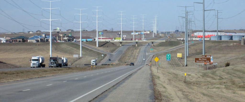
18 Study Area Issues, Needs, Segmented Bicycle/Pedestrian Facilities and Design Considerations Ramp Terminal Intersections - Traffic Operations - Safety - Traffic Growth - Sight Issues - Commuter Traffic Route


19 Study Area Issues, Needs, Large Vehicle Mobility and Design Considerations Lane Change/Turn Conflicts Bridge Width and Type; Maintenance of Traffic during Construction Left-turn from Thru Lane Transmission Towers

20 Interchange Modification Justification Study (Analysis) Area and Alternatives Development Process IMJR Alternatives Development Process Gather information and establish issues and needs Includes public involvement opportunity Develop Conceptual Alternatives Evaluation Refine Screened Alternatives Evaluation Includes public involvement opportunity Select Build Option Includes public involvement opportunity
 Prepare EA document with recommended alternative.")
21 Environmental Assessment Study Area and Process Summary The EA Process can be defined by three distinct steps: 1) Assess project needs and research the existing environment; 2) Identify potential project alternatives and evaluate their impacts on the environment; 3) Prepare EA document with recommended alternative. At the end of this process, the EA is made available to the public for comment.
22 Environmental Assessment DRAFT Purpose and Need Purpose of the Project The I-90 Exit 406 Interchange was constructed in The bridge is not considered structurally deficient at this time. However, the bridge has been determined by the SDDOT Office of Bridge Design to be at the end of its service life and replacement of the bridge is being pursued before any major rehabilitation work is necessary. The purpose of the Project is to reconstruct the I-90 Exit 406 Interchange to meet current design standards, improve safety, and increase the efficiency of the transportation system along the I-90 interstate corridor and Splitrock Boulevard.

23 Crash History SD 11 / Splitrock Boulevard Intersections ( ) I-90 WB Ramp Terminal Intersection I-90 EB Ramp Terminal Intersection Ash Street Hemlock, Birch, and Redwood Intersections 9 Total Crashes 21 Total Crashes 8 Total Crashes 7 Total Crashes 6 Rear-end 3 Angle 10 Angle 9 Rear-end 2 Single Vehicle 4 Angle 3 Rear-end 1 Single Vehicle 5 Angle 2 Rear-end SD 11 / Splitrock Boulevard Segments ( ) Hemlock Boulevard to I-90 Eastbound Ramp Terminal Intersection 2 Total Crashes 2 Single Vehicle I-90 Eastbound Ramp Terminal Intersection to Ash Street 14 Total Crashes 6 Angle 5 Rear-end 3 Sideswipe Ash Street to Redwood Boulevard 4 Total Crashes 3 Angle 1 Rear-end I-90 Freeway Segments ( ) I-90 Freeway Segment West of Exit Total Crashes 8 Single Vehicle 2 Other 1 Angle I-90 Exit 406 Interchange 19 Total Crashes 13 Single Vehicle 2 Rear-end 2 Sideswipe Same Direction 2 Other I-90 Freeway Segment East of Exit Total Crashes 11 Single Vehicle 3 Other 1 Rear-end 1 Sideswipe Same Direction
24
25
26

27
28 Level of Service (LOS) Definitions Highway Capacity Manual 2010 Signalized Intersections Basic Freeway Segment LOS A B C D Description Very minimal queuing; excellent corridor progression Some queuing; good corridor progression Regular queuing; not all demand may be serviced on some cycles (cycle failure) Queue lengths increased; routine cycle failures Intersection Control Delay (seconds/vehicle) 10 > > > E Majority of cycles fail > F Volume to capacity ratio near 1.0; very long queues, almost all cycles fail > 80 All-Way Stop-Controlled and Two-Way Stop-Controlled Intersections LOS Description Density (passenger cars/mile/lane) A Free-flow operation 11 B C D E Reasonably free-flow operation; Minimal restriction on lane changes & maneuvers Near free-flow operation; noticeable restriction on lane changes & other maneuvers Speed decline with increasing flows; Significant restriction on lane changes & other maneuvers Facility operates at capacity; Very few gaps for lane changes & other maneuvers; Frequent disruptions & queues > > > > F Unstable flow; operational breakdown > 45 LOS Description Control Delay (seconds/vehicle) Freeway Merge and Diverge Segments A Queuing is rare 10 B Occasional queueing > C Regular queueing > D Queue lengths increased > E Significant queuing > F Volume to capacity ratio near 1.0; very long queues All-way stop-controlled intersections reports intersection control delay. Two-way stop-controlled intersections reports worst-case stop-controlled approach. No intersection control delay is calculated. > 50 LOS Description Density (passenger cars/mile/lane) A Unrestricted operations 10 B Merging and diverging maneuvers noticeable to drivers > C Influence area speeds begin to decline > D Influence area turbulence becomes intrusive > E Turbulence felt by virtually all drivers > 35 F Ramp and freeway queues form Demand Exceeds Capacity
29 Thank You! Stay Connected Throughout the study, materials will be posted on the project website to keep the public informed on the progress of the study. Contact Us Jon Wiegand, PE, PTOE Mark Your Calendar Next Public Information Meeting: November/December 2016 You will have the opportunity to review various interchange and corridor concepts developed for further evaluation, provide feedback on each concept, and be a part of the screening process. Final Public Information Meeting: Spring 2017 This will be an opportunity for you to review and comment on a proposed interchange and crossroad Preferred Alternative. Consultant Project Manager HR Green, Inc jwiegand@hrgreen.com Steve Gramm, PE SDDOT Project Manager South Dakota Department of Transportation steve.gramm@state.sd.us Leave a Comment Today, please provide feedback on issues you experience at the I-90 Exit 406 interchange and along the SD 11 / Splitrock Boulevard corridor. Comment forms are available at the registration table. Completed forms may be placed by the entryway or mailed/ ed to Jon Wiegand or Steve Gramm by August 23,


30 MARKET I-90 EXIT 406 INTERCHANGE MODIFICATION STUDY AND ENVIRONMENTAL ASSESSMENT AUGUST 9, 2016 Public Meeting & Open House
31 STUDY TEAM Study Advisory Team South Dakota Department of Transportation (SDDOT) Federal Highway Administration (FHWA) Sioux Falls Metropolitan Planning Organization (MPO) City of Brandon Study Consultant HR Green Short Elliott Hendrickson (SEH) 106 Group I-90 Exit 406 IMJR and EA
32 INTERCHANGE IMPROVEMENTS TIMELINE Study Design Construction programmed for letting in FY I-90 Exit 406 IMJR and EA


33 I-90 EXIT 406 HISTORY 2010 Decennial Study Alt. 1: SD 11 and Bridge Improvements Alt. 2: Single Point Urban Interchange I-90 Exit 406 IMJR and EA

34 STUDY AREA I-90 Exit 406 Interchange SD 11 / Splitrock Blvd I-90 Exit 406 IMJR and EA
35 STUDY COMPONENTS A. Interchange Modification Justification Report (IMJR) A. Development of alternatives B. Traffic operations C. Safety D. Multi-modal mobility E. Access F. Constructability I-90 Exit 406 IMJR and EA
36 STUDY COMPONENTS B. Environmental Assessment (EA) Environmental considerations, such as Wetlands and waterways Archeological resources Historical structures Noise Regulated materials Parkland Threatened and Endangered Species Air water quality I-90 Exit 406 IMJR and EA
37 STUDY OVERVIEW AND SCHEDULE A. Establish issues and needs B. Concept development and initial screening C. Refine Build Options and analysis D. IMJR and EA development; identify Recommended Alternative May August 2016 August September 2016 October December 2016 October 2016 May 2017 I-90 Exit 406 IMJR and EA
38 ISSUES AND NEEDS: TRAFFIC DEMAND Average Daily Traffic Segment 2016 ADT 2045 ADT % Increase I-90, West of Exit 406 SD 11, South of I-90 25,000 47,000 88% 13,000 23,000 77% I-90 Exit 406 IMJR and EA
39 ISSUES AND NEEDS: TRAFFIC OPERATIONS Level of Service (AM/PM) Intersection Existing Future-Year WB Ramp Intersection EB Ramp Intersection F/F C*/F F/F F/F I-90 Exit 406 IMJR and EA

40 ISSUES AND NEEDS: CRASH HISTORY SD 11 Intersections SD 11 Roadway Segments Freeway Segments I-90 Exit 406 IMJR and EA


41 ISSUES AND NEEDS: 4-LANE SECTION Speed, interchange congestion Southbound lane addition Northbound left-turn I-90 Exit 406 IMJR and EA

42 ISSUES AND NEEDS: SD 11 BRIDGE OVER I-90 Functionally obsolete Width Vehicular Multi-modal Bridge type I-90 Exit 406 IMJR and EA


43 DESIGN CONSIDERATIONS Maintaining Traffic Transmission Towers Vehicle Size Access Multi-modal Connectivity I-90 Exit 406 IMJR and EA
44 TODAY S INVOLVEMENT OPPORTUNITIES Identify Study Area Issues and Needs Concept development and evaluation Purpose and Need Comments Leave comment form at entryway Mail/ comment form to project contact Discuss with project representatives Submit comment via project website Due by August 23 I-90 Exit 406 IMJR and EA

45 THANK YOU! Project Website Next Public Meeting: November/December 2016 Project Contacts Jon Wiegand, PE, PTOE Consultant Project Manager HR Green, Inc Steve Gramm, PE SDDOT Project Manager South Dakota Department of Transportation I-90 Exit 406 IMJR and EA
46
47
48
49
50
51
52
53
54
55
56
57
58 I-90 Exit 406 Interchange Modification Study and Environmental Assessment Public Involvement #1 Summary Meeting Date: August 9, /Website Comments 8/19/16 1) Hwy 11 is our only outlet. East Birch Street in Brandon has only one entrance/exit which is onto Hwy 11. We have a newly developed area and have an estimated 80+ families which use that exit. This includes 40+ houses and several apartment buildings. The project study mentioned that traffic gets backed up past McDonald's on Hwy 11. I mentioned that this was incorrect and that traffic can get backed up to the Redwood stoplight, one intersection south of Birch. When traffic is backed up this far we are blocked from exiting Birch. This is especially an issue when kids and school buses are trying to take a left turn and get to school in the winter. 2) Many close calls entering Hwy 11 South from I-90 E I have had some close encounters with vehicles traveling south on Hwy 11 as they come over the bridge. Immediately after the bridge Hwy 11 has 2 lanes and about half of the vehicles want to switch to the outside lane and enter one of the first few businesses on the west side of Hwy 11. This means people are speeding up to 45 mph and someone is slowing down in front of them to immediately turn. 3) Additional traffic on Hwy 11 is causing larger backups. There seems to me an increased number of vehicles traveling south from the Corson side on Hwy 11. This includes several large wind turbine pieces being piloted onto I-90. This is causing more vehicles traveling north to backup traffic on Hwy 11 north and all traffic on the bridge as most are waiting to enter I-90 West. 4) 2 vehicles on Birch Street both taking left Because of the way that Birch Street crosses Hwy 11, if two vehicles are on opposite sides and both taking a left they will be in each other's way. This has caused several near wrecks as neither side is unaware that the other will be in their path. 5) Hwy 11 is not bike friendly We live in a area that has to take Hwy 11 to get anywhere else in Brandon. This makes it unsafe to allow kids to bike outside our area. Hwy 11 is 45 mph, 5 lanes across, and busy. This doesn't make it easy to use the roads on bikes and limits bikes to usually ride on the sidewalks.
59 I-90 Exit 406 Interchange Modification Study and Environmental Assessment Public Involvement #1 Summary Meeting Date: August 9, /19/16 Thank you for the public information meeting. You touched on all of my concerns about the present interchange. I wanted to give my input though. I come from work in Sioux Falls around 10:15 pm, and I live in Corson. I have a Mercury Grand Marquis in which I sit kind of low. While making the left turn, I watch for the glow of headlights that I don't directly see if the oncoming vehicle is a lower car. Then, I still proceed cautiously. As I proceed north across the bridge, I am very watchful of cars coming off of I-90 west. I have had three close calls in the past couple years where a car would pull out right in front of me. I don't know if they didn't see me or what. For a while, the street lamp at the north end of the bridge was burned out, so that didn't help. If I see a car waiting to come onto Highway 11, I turn on the dome light in my car, hoping it will help them see me better. I like the idea of some sort of turning lane, and a pedestrian / bicycle area. I prefer a single curve ramp going on and off, like what is there now. I don't like the double curve? ramp like the one going onto I-90 west at Luverne, MN, because I can't use the full length of the ramp to get my speed up. Also, stop lights may help presently at the bridge. Thank you again for your presentation, and for allowing us to give our input. 8/9/16 I commute through the I-90 and Hwy 11 interchange a minimum of twice daily, typically at 7:30 to 8:00 AM (north and west bound) and 5:00 to 5:30 PM (east and south bound). I have experienced many long wait times in backed up traffic. I have also been lucky enough not to have had an accident in my travels but have had numerous close calls. These begin with north bound cars stopped in traffic trying to enter the BP station or the hotels in the absence of a turning lane. I have had north bound cars speed past me in the east lane and dive in front of me to cross the bridge. A semi tractor trailer combo once pulled out in front of me from the east off ramp and turned north. I left 30 feet of skid marks to avoid a collision. At least once a month I am forced to stop on the shoulder of I-90 because the east bound off ramp traffic is backed up on to the interstate. Once at Hwy 11 the danger continues when trying to turn south. I always stay in the west lane but have had many near misses with south bound cars wanting to access the hotels or Tailgaters. The bridge railing blocks sight of most vehicles turn signals if and when they are used. Other unsafe observations are a number of cars on the west bound off ramp turning north and then making an immediate U turn on Hwy 11 to go south. I really love it when the Marmen lead and chase vehicles block traffic at 7:45 AM to allow a tower section on to the west bound on ramp. That is one problem that could be avoided by placing time restrictions on Marmen s transport releases. If I could make other suggestions, a short term solution would be traffic signals installed as soon as possible on both ends of the bridge. Long term would be a new bridge a minimum of five lanes (if the interchange is to remain in the current configuration) with the turning lane to extend south far enough to allow access to the BP station, Tailgaters and the hotels. I know this is a very complicated issue and there will be more than enough opinions to go around. I just want to thank you for allowing us this opportunity to supply some input. Good luck and please keep me informed of future meetings.
60 I-90 Exit 406 Interchange Modification Study and Environmental Assessment Public Involvement #1 Summary Meeting Date: August 9, /3/16 a) First off, THANK YOU for initiating this. It is long needed and it seems we do not get very far with our state representatives. b) My daughter almost lost her life in car crash south of the bridge in December We attribute this, as did the deputy sheriff and our insurance agent, to the bridge and conditions around it. In fact, the insurance agent, when notified by deputy sheriff, said let me guess where it was. c) there seems to be a growing problem, even if limited to 1 small portion of day, to cars exiting into Brandon around 5pm. Traffic can back up onto the interstate. d) Finally, there is heavy truck traffic in 2 areas- 1) CHS trucks coming from the factory by Corson, 2) Coming from the South on Splitrock. According to daughter's accident report, this truck traffic was directly responsible for her accident. I have thought long about this. To me, my suggestion is change speed limits. As one leaves Brandon, the limit goes from 30 to 45 as you approach the bridge. This is way too fast for such a narrow bridge with such heavy traffic. Many commuters in the am, turning west onto I 90, are backed up past the gas stations. Additionally, traffic is thus slowed down quickly to make that left turn. More dangerous in winter too. I would also suggest such a speed limit change coming south from Corson. In terms of lights, that may not be a bad idea. In terms of bridge itself, I am not an expert, but widening seems good or at least adding a left hand- turning lane going northbound. In terms of the exit, maybe 2 lanes, or widening. Maybe a left turn lane as you take exit ramps and go north. In sum, thanks for a long needed discussion. It is a very busy interchange, especially during commuting times. My take is for sure change the speed limits!!!
61 I-90 Exit 406 Interchange Modification Study and Environmental Assessment Public Involvement #1 Summary Meeting Date: August 9, 2016 Website Comment: 8/23/16 Perhaps there are some short term things that can be done to help the situation. Maybe all way stops on both side of the bridge to force traffic to be metered hopefully reducing the long waits at the off-ramps a peak traffic times in the morning and evening. Making Holly Blvd 4 lane with a turn lane all the way to Sioux Falls would also help. Ask Marman Energy to avoid intersection between 7-8AM and 5-6PM might also help. Also, please add my name to the list of people notified for future meetings and notifications about the project. Thank you Website Comment: 8/19/16 Add lights at the North and South intersection off & on ramps on Split Rock, for peak time (7:15 to 8:15am/ 4:15 to 5:45pm) use. During off peak, the oncoming traffic to SR, would have flashing red, those getting off SR onto I-90 would have flashing yellow. Keep it simple. If this doesn't work, then do major lane redesign down the road. Website Comment: 8/11/16 Since traffic will be detouring to Valley Springs Exit 410, could 'No Dynamic Braking' signs be posted on highway 262 into Brandon? It is a problem now and I can't imagine what it would be like with the increased flow. Website Comment: 8/10/16 WE NEED STOPLIGHTS TO HELP CONTROL TRAFFIC AT THIS EXIT!!!! There have been times we have side swiped from cars when turnining left going north onto hwy 11. Part 2: I want to add to my previous statement, that I am not the only person that turns right on the north exit ramp in order to turn around to go south. I would say that I have observed more than half the people exiting on that exit doing the exact same thing.
62 I-90 Exit 406 Interchange Modification Study and Environmental Assessment Public Involvement #1 Summary Meeting Date: August 9, 2016 Website Comment: 8/8/16 To be perfectly honest, this study should have been done years ago. The interchange at exit 406 is a disaster. In the morning, I come to Brandon from the east on the interstate. I get off the interstate, turn RIGHT/NORTH when I should be turning left/south and then do a turn-around in the co-op driveway. If I did not do this, I would never get anywhere on time, as the stream of traffic is constant from the south and frequent from the north. The rare person that can actually turn left from the ramp is likely waved through by some nice driver. And even at times when it is not heavy traffic, the visibility over the concrete barrier to see cars coming is extremely poor. In the evening, when I'm coming to the same intersection from the west, it's again a disaster. People start slowing down for the exit at least three-quarters of a mile before the exit, causing a traffic hazard. Often the traffic is so backed up on the southbound exit, that the line extends out onto the interstate itself. This is unacceptable and extremely dangerous. Something needs to be done NOW. Even if we could hang a temporary stoplight above the north ramp entrance/exit, it would help a lot. Website Comment: 8/7/16 This seems like a good interchange for a single point interchange. I know you'll look at everything and decide what is feasible. My only gripe is that SDDOT under-signs SPUIs. To assume that local motorists know how to navigate those interchanges is fine, but people from out of town, often times, do not. The worst offender of this under-signage is the 12th Street/I-29 interchange. You have over 6 lanes of traffic on 12th at the interchange and no overhead signage directing traffic. Funny, since that interchange has a relatively high accident rate since it was reconstructed. And that is a popular exit for out of town traffic. My advice is if this is not going to be reconstructed to a standard diamond, to make sure it's adequately signed. Brandon has plenty of out of town traffic as well. Website Comment: 8/2/16 My only concern and I wouldn't expect it to be a big challenge is getting our asphalt trucks on/off the interstate. We have doubles (one semi with two trailers) coming in and out of the terminal. Just want to making sure there is enough turning radius at the intersections or ramps to access the interstate from our asphalt terminal. Thanks for the opportunity to send comments.
63 I-90 Exit 406 Interchange Modification Study and Environmental Assessment Public Involvement #1 Summary Meeting Date: August 9, 2016 Website Comment: 7/26/16 I have seen and experienced long wait times and many "near misses" with accidents on the bridge, especially involving left hand turns. As the growth of the industrial area continues to develop north of the interstate, it would be ideal to have a pedestrian area with a cement buffer to allow safe passage of pedestrians walking to and from work from the south side of I-90. Website Comment: 7/26/16 The interchange is backed up pretty bad in the morning with cars from Brandon waiting to turn left to get on I90, cars backed up from East waiting to turn left to go into Brandon, trucks hauling turbine blades stopping traffic as it tries to turn onto the ramp to I90. It's a complete mess. So many times I've almost got broadsided as cars race over the bridge into Brandon and I'm sitting at the exit to turn right into Brandon trying to see if anyone is coming over the bridge. I have a car and my view is blocked by SUVs and trucks. Plus cars coming over the bridge into Brandon don't realize there's another lane there for the ramp exiters. So many near misses. Plus the entrances to the hotel/tailgators is also a nightmare. They stop in the one lane going north, right before the bridge, and wait for southbound traffic coming off the bridge to clear so they can turn into the hotel/tailgators. Again, many wrecks there or near misses. That whole section is just a nightmare. Website Comment: 7/26/16 How will you maintain traffic across I-90 while the construction is going?
64 I-90 Exit 406 Interchange Modification Study and Environmental Assessment Public Involvement #1 Summary Meeting Date: August 9, 2016 Project Team Meeting Notes Craig Smith, SDDOT Improvements are needed for Marmon trucks to turn onto SD11, they block SD11 to make the movement. A company that manufactures steel plates is developing near Marmon, this will add traffic to the already congested area. Waiting until is too long, need to look at interim improvements to deal with the interchange ramp congestion. Consider traffic signals at interchange as an interim improvement. I90 EB off ramp, trying to make a north bound left is difficult due to the sight distance to the north. To improve sight distance vehicles creep to the right and then a second vehicle turning left will come along side of them to turn left. Bridge and rail add to the sight distance issue. Ash Street They were in a crash along SD11 at the Ash Street intersection. While going NB a truck was turning right onto Ash, but couldn t make the turn due to a EB vehicle turning left off of Ash. The vehicle on Ash made the left turn and collided with the NB vehicle on SD11 in the second lane. Trucks don t use Ash to get onto SD11, many are avoiding this intersection and going to the signalized Redwood Blvd intersection With the sight distance issues at the interchange and congestion, is 45 mph too fast? Need to consider lowering the speed limit through this area. Steve Gramm, SDDOT In the SW quadrant, land owner claims the ditch is higher than his lot. Water pools and then drains through his property during the spring melt and when there is a heavy (3-4 inch) rain. The interchange should be rebuilt sooner. Birch is the only access to an entire subdivision. Some mornings the queue from the interchange backs up beyond McDonalds and goes into the Birch intersection. Locals treat the EB off ramp as a two lane ramp, but it s not striped so when a non-local uses it as a single lane ramp it hoses everything up. Some of those folks that take a right turn from the WB off-ramp to then do a U-turn flip the U-turn within 10 feet of the intersection. Marmen always has a truck leaving during the AM rush on Thursdays. Is there a way to make them not haul during the rush? There are a lot of trucks that make left turns from Ash. Rice Street / Holly Boulevard should be 5 lanes from SD11 to I-229. If that were done, the interchange would return to normal.
65 I-90 Exit 406 Interchange Modification Study and Environmental Assessment Public Involvement #1 Summary Meeting Date: August 9, 2016 Jon Wiegand, HR Green Continued development of industrial area west of SD 11, north of Hemlock, in near future. Location provides BNSF rail access. Evaluate possibility of traffic signals as interim measure at ramp terminal intersections. Trucks: delay and congestion on Ash Street trying to turn left onto SD 11. Alternate route is 9 th Avenue to Redwood Boulevard to SD 11. Trucks on Ash Street can make it difficult to access gas station and The Warehouse. Difficulty seeing cars over bridge rail from ramp approach. 2 people noted high speeds over the bridge, one of which noted the high speeds along SD 11 to the south as well. One attendee wanted to clarify that we will indeed be looking at a variety of interchange types. Indicated that the study would look at a variety and not just those presented in the 2010 Decennial Study. Discussed the Ole Christopherson homestead history with an attendee.
66 I-90 Exit 406 Interchange Modification Study and Environmental Assessment Public Involvement #1 Summary Meeting Date: August 9, 2016 Stakeholder Meetings August 9, 2016, 6 p.m. 7:30 p.m. -Sign-in Sheets -Agenda -HRG Notes/Discussion Summary
67
68
69
70 I-90 Exit 406 Interchange Modification Study and Environmental Assessment Stakeholder Meeting Agenda August 9, 2016 Introductory Information A. Introductions B. Study Overview & History C. Study Area a. I-90 from BNSF railroad tracks to Split Rock Creek bridges b. SD 11 from Hemlock Boulevard to Redwood Boulevard D. Improvements Timeline a. Interchange Improvements programmed for letting in FY E. Study Timeline a. May 2016 June 2017 F. Purpose of today s meeting a. Identify issues and needs within study area to assist in: i. Development and evaluation of interchange improvements ii. Development of Purpose and Need for Environmental Assessment Group Discussion G. Issues and Needs within Study Area (Examples) a. Traffic Growth and Operations b. Safety c. SD 11 bridge crossing of I-90 d. Access and connectivity e. Multi-modal facilities f. Design Considerations i. Vehicle size ii. Transmission towers iii. Maintenance of traffic during construction iv. Multi-modal facilities
71 Meeting Notes Project: Project #: Date: I-90 Exit 406 Interchange Modification Study & Environmental Assessment August 9, 2016 Representatives Present: FHWA Mark Hoines DOT City Paul Sanow, Bryan, Larry HR Green SEH Coffee Cup Nick Fosheim City Council Barb Fish CHS Jebro - Noel Alliance Communication Antique Mall David Billion Midwest Railcar School Marmon Energy Questions 1. How do you alleviate the traffic that is backed up through the intersections? Left turn lane, signals, phased timing, creates issues; bridge is an umbrella bridge and cannot be widened a. Alliance has DOT looked at Hwy 100 and those affects? i. Steve Gramm Hwy 100 won t alleviate anything; roundabouts at ramp terminals may be a temporary option 2. Will sidewalks be put along Hwy 11? a. Barb Fish yes, this will be looked at and planned for. Sidewalks will be planned in all options 3. Do we anticipate ROW restrictions? a. Noel Schultz concept will look at those potential needs b. Steve Gramm would a new bridge be built off alignment transmission towers will be a constraint access through and across interchange during project 4. What are the different types of interchanges that we are looking at? a. Paul Sanow not to that point yet; diamond, diverging diamond, modified single point 5. Any discussions on changing the on and off ramps? a. Midwest Rail yes, ramps do not meet current standards --- bridges over Split Rock Creek scheduled for next year 6. How much would ROW, transmission lines and ramps affect option types? a. Paul Sanow definitely they will all play into the selection \\hrgsfdc\data\ \design\meeting\public_meeting_1\public_meeting_summary_info\comments_meetingnotes\min StakeholderNotes-CL.doc
72 Meeting Notes b. Steve Gramm will come down to cost/benefit ratio 7. Do we look at the business type? a. Barb Fish yes, design vehicles and traffic for businesses looked at 8. What are traffic counts and what was design traffic numbers? a. Nick Fosheim i. I-90 25K W. 47K Hwy 11 S. 13K-22 ii. I-90 18K E. b. SEH did numbers while school was in (May) c. AM peak; 515 vehicles & 130 left d. PM; 700 N. & 500 left 9. Can I-90 be run over the road a. Coffee Cup Steve Gramm - it would be very expensive, would need ½ mile in each direction to adjust grade 10. Will I-90 handle traffic through 2045 a. Midwest Railcar yes, volumes support this 11. How long will bridge construction take a. Dave Billion Steve Gramm it depends; 1.5 years in halves; 1 year if off lane 12. Will bridge be planned for 3 lanes or more? a. Dave Billion Steve Gramm yes, would be built for increased volumes and also to be able to be widened 13. Jon prompt for safety a. Crash history at intersections of interchange i. Hemlock to Redwood 14. Industrial Park will continue to grow need to plan for (Neal Schultz) 15. Marmon towers each year (200 ft long) a. MNDOT requires a Hypo will always go west 16. Big tandems don t go to MN (Noel) 17. CHS a trucks/year inbound/out grain b trucks/year inbound/out feed 18. Jennica/Jon truck info will help determine what is needed a. CHS roundabout will not work with their trucks 19. Midwest Railcar has speed limit reduction been looked at a. Steve Gramm type of interchange will help dictate speed 20. Marmon can they get a WB on ramp at their facility a. Mark Hoines - No \\hrgsfdc\data\ \design\meeting\public_meeting_1\public_meeting_summary_info\comments_meetingnotes\min StakeholderNotes-CL.doc
73 Meeting Notes 21. Pau Sanow there are some steep grades coming up to Hwy 11 a. Jon yes, grades will be looked at (interchange will dictate but is not the only factor) 22. Dave Billion 5 lane section will this go through? a. Will look at that but also access control with median 23. Jon prompt Redwood Blvd Intersection a. Paul Sanow with access control would you look at U-turn etc. or traffic pattern at signal b. N. of interchange c. Steve Gramm do they have pilot to block NB & SB traffic? i. Marmon sometimes will have a highway patrol block in front; rear steer trucks help only do towers, no blades 24. I think we definitely need truck info from Marmon a. Marmon instructs drivers to avoid rush hour 25. Marmon will we look at changing the ramp configurations? a. Yes b. Sgt Bluff interchange gate etc. to accommodate large trucks 26. Marmon railroad improvements a. Steve Gramm talk to county \\hrgsfdc\data\ \design\meeting\public_meeting_1\public_meeting_summary_info\comments_meetingnotes\min StakeholderNotes-CL.doc

74 Meeting Notes 3:30 Stakeholder Meeting Notes Representatives Present: FHWA DOT City Paul Sanow, Bryan HR Green SEH Stockwell Jon B. Concrete Materials Billy Bollema Celebrate Church Harr Lemme Brad & Joel Questions 1. Billy Pollema so study will be complete by this time next year? a. Yes, June Church build out (no school etc. at this point) YES 3. Brad are numbers reflected of new model? a. Yes updated traffic demand model 4. Church I-90 volume? Current 25K W. and 17K E. 5. Joel at what point during study do you determine the access needs/limitations a. During concept development 6. Billy future plans for growth at sand plant/quarry will need to be discussed in next month or so discuss rail vs. truck access 7. Billy Sand plant 700 acres; quarry 185 acres; finalizing quarry design. Designing 1000 tph crusher (current 700 tph crusher) will rail to old site at Madison retail site 8. Crash info a. Jon B. would access be maintained at all times during construction YES 9. Church locations both Pastors are 6 months in very new 10. Multi-model pedestrian and bicycle usage/access \\hrgsfdc\data\ \design\meeting\public_meeting_1\public_meeting_summary_info\comments_meetingnotes\min StakeholderNotes-CL.doc
PRESENTATION WILL BEGIN AT APPROXIMATELY 6:05 P.M. I-90 EXIT 406 INTERCHANGE MODIFICATION STUDY AND ENVIRONMENTAL ASSESSMENT MARKET
 PRESENTATION WILL BEGIN AT APPROXIMATELY 6:05 P.M. MARKET I-90 EXIT 406 INTERCHANGE MODIFICATION STUDY AND ENVIRONMENTAL ASSESSMENT JANUARY 23, 2017 Public Meeting & Open House #2 TODAY S MEETING Purpose:
I-90 Exit 406 Interchange Modification Study and Environmental Assessment. Public Involvement #2
 I-90 Exit 406 Interchange Modification Study and Environmental Assessment Public Involvement #2 January 23, 2017 Holiday Inn Express Convention Center Brandon, SD Public Comments Summary Public Meeting
Draft North Industrial Area-Wide Traffic Plan
 Summary of North Industrial and Hudson Bay Industrial Recommended Improvements Table 1. Summary of s Item Location 1 2 3 4 5 6 7 8 9 10 11 12 Millar Ave north of 51st St Super 8 Motel back lane 400 Block
Chapter 4 Traffic Analysis
 Chapter 4 Traffic Analysis PURPOSE The traffic analysis component of the K-68 Corridor Management Plan incorporates information on the existing transportation network, such as traffic volumes and intersection
PEDESTRIAN ACCOMMODATIONS DPS 201 AT INTERCHANGES
 PEDESTRIAN ACCOMMODATIONS DPS 201 AT INTERCHANGES UNDERSTANDING THE ISSUES Intersections of freeway ramp terminals at crossroads are the most critical components of an interchange Challenge: balance mobility
Los Altos Hills Town Council - June 18, 2015 Palo Alto City Council June 22, AGENDA ITEM #2.B Presentation
 Los Altos Hills Town Council - June 18, 2015 Palo Alto City Council June 22, 2015 AGENDA ITEM #2.B Presentation Previous Presentations Los Altos Hills Town Council in May 2014 and February 2015 Palo Alto
Offset Single Point Interchange I-25 at Rio Bravo Boulevard Albuquerque, New Mexico
 Offset Single Point Interchange I-25 at Rio Bravo Boulevard Albuquerque, New Mexico INSTITUTE OF TRANSPORTATION ENGINEERS 2016 WESTERN DISTRICT MEETING JULY 11, 2016 7/11/2016 1 Project Vicinity Map 7/11/2016
133 rd Street and 132 nd /Hemlock Street 132 nd Street and Foster Street MINI ROUNDABOUTS. Overland Park, Kansas
 133 rd Street and 132 nd /Hemlock Street 132 nd Street and Foster Street MINI ROUNDABOUTS Overland Park, Kansas September 1, 2017 TABLE OF CONTENTS 1. INTRODUCTION... 1 2. LITERATURE REVIEW... 1 3. CONCEPT
METHODOLOGY. Signalized Intersection Average Control Delay (sec/veh)
") Chapter 5 Traffic Analysis 5.1 SUMMARY US /West 6 th Street assumes a unique role in the Lawrence Douglas County transportation system. This principal arterial street currently conveys commuter traffic
Chapter 5 Traffic Analysis 5.1 SUMMARY US /West 6 th Street assumes a unique role in the Lawrence Douglas County transportation system. This principal arterial street currently conveys commuter traffic
Route 28 (South Orleans Road)/Route 39 (Harwich Road)/Quanset Road Intersection
/Route 39 (Harwich Road)/Quanset Road Intersection") TRAFFIC FEASIBILITY STUDY Route 28 (South Orleans Road)/Route 39 (Harwich Road)/Quanset Road Intersection Orleans, Massachusetts Prepared for: Town of Orleans Prepared by: Fay, Spofford & Thorndike, LLC
TRAFFIC FEASIBILITY STUDY Route 28 (South Orleans Road)/Route 39 (Harwich Road)/Quanset Road Intersection Orleans, Massachusetts Prepared for: Town of Orleans Prepared by: Fay, Spofford & Thorndike, LLC
Bay to Bay Boulevard Complete Streets Project
 Bay to Bay Boulevard Complete Streets Project Dale Mabry Highway to Bayshore Boulevard February 08, 2018 Photo Source: Tampa Bay Times Alessandra Da Pra Meeting Format Introduction Resurfacing Information
Community Advisory Committee
 Community Advisory Committee Meeting #1 November 19, 2014 Presentation Team Matt Fulda, Greater Bridgeport Regional Council Chris Granatini, P.E., Tighe & Bond Craig Yannes, P.E., PE PTOE, Tighe & Bond
Subject: Solberg Avenue / I-229 Grade Separation: Traffic Analysis
 MEMORANDUM Transportation Bill Troe, AICP Jason Carbee, AICP 12120 Shamrock Plaza Suite 300 Omaha, NE 68154 (402) 334-8181 (402) 334-1984 (Fax) To: Project File Date: Subject: Solberg Avenue / I-229 Grade
VT15 / Allen Martin Drive Intersection Scoping Study
 VT15 / Allen Martin Drive Intersection Scoping Study ALTERNATIVES PRESENTATION MEETING DECEMBER 19, 2016 Agenda Study Area Project Background Existing Conditions Identified Issues Proposed Alternatives
Capital Region Council of Governments
 March 23, 2018 Capital Region Council of Governments PROJECT CONCEPT REPORT Realignment of Swamp and Northfield Road s approaches to Route 44 (Boston Turnpike) Town of Coventry SUMMARY: The Town of Coventry
Mark Malone, P.E. SD DOT
 Mark Malone, P.E. SD DOT SD10 Grading & Surfacing From 8 th Ave W to 8 th Ave E 1 mile plus transition lengths Complete Urban Reconstruction Grading, C&G, Storm Sewer, Sidewalk, Concrete Surfacing Railroad
Intersection Traffic Control Feasibility Study
 Intersection Traffic Control Feasibility Study CSAH 9 at CSAH 60 (185th Avenue) Prepared For: Dakota County Transportation Department Western Service Center 14955 Galaxie Avenue, 3rd Floor Apple Valley,
Traffic Circulation Study for Neighborhood Southwest of Mockingbird Lane and Airline Road, Highland Park, Texas
 ARIZONA TEXAS NEW MEXICO OKLAHOMA February 13, 2015 Mr. Meran Dadgostar P.E., R.S. Town of Highland Park 4700 Drexel Dr. Highland Park, Texas 75205 Re: Traffic Circulation Study for Neighborhood Southwest
Washington St. Corridor Study
 FIGURE 7.17 Bridge Alternatives - Cross Sections 86 Discarded Alternative: Short-Term Bridge Repair Short-term repairs and west bridge span replacement were considered during analysis. Short-term repairs
INNOVATIVE INTERSECTION DESIGN
 INNOVATIVE INTERSECTION DESIGN J. Eddie Valtier, P.E. ELP TP&D Director Introduction Why Do We Need To Start Looking For Innovative Intersection Designs? Congestion is worsening and traffic volumes and
Figure 1: Vicinity Map of the Study Area
 ARIZONA TEXAS NEW MEXICO OKLAHOMA May 5, 2016 Mr. Anthony Beach, P.E. BSP Engineers 4800 Lakewood Drive, Suite 4 Waco, Texas 76710 Re: Intersection and Access Analysis along Business 190 in Copperas Cove
WELCOME. Stakeholder Involvement Group Meeting #2 Round Lake Public Works October 24, 2018
 WELCOME Stakeholder Involvement Group Meeting #2 Round Lake Public Works October 24, 2018 MEETING AGENDA 1. Welcome and Introductions 2. Study Progress Update 3. Problem Statement 4. Technical Analysis
PRELIMINARY DRAFT WADDLE ROAD / I-99 INTERCHANGE PROJECT ALTERNATIVE ANALYSIS FINAL TRAFFIC SUMMARY REPORT
 PRELIMINARY DRAFT WADDLE ROAD / I-99 INTERCHANGE PROJECT ALTERNATIVE ANALYSIS FINAL TRAFFIC SUMMARY REPORT Prepared by: In Association with: November 2013 EXECUTIVE SUMMARY Patton Township, in partnership
JONESBORO HIGHWAY 63 HIGHWAY 18 CONNECTOR STUDY
 JONESBORO HIGHWAY 63 HIGHWAY 18 CONNECTOR STUDY Craighead County May 2007 JONESBORO HIGHWAY 63 HIGHWAY 18 CONNECTOR STUDY Craighead County May 2007 Prepared by Planning and Research Division Arkansas State
APPENDIX G: INTERSECTION NEEDS AT OKEECHOBEE BOULEVARD
 APPENDIX G: INTERSECTION NEEDS AT OKEECHOBEE BOULEVARD INTERSECTION NEEDS AT SR 7 and OKEECHOBEE BOULEVARD SR 7 Extension Project Development and Environment (PD&E) Study From Okeechobee Boulevard (SR
4. ENVIRONMENTAL IMPACT ANALYSIS 9. TRANSPORTATION AND TRAFFIC
 4. ENVIRONMENTAL IMPACT ANALYSIS 9. TRANSPORTATION AND TRAFFIC 4.9.1 INTRODUCTION The following section addresses the Proposed Project s impact on transportation and traffic based on the Traffic Study
Freeway System Considerations
 Session 11 Jack Broz, PE, HR Green May 5-7, 2010 Freeway System Considerations Mainline Transit: Shoulder Operations, BRT, Stations HOV, HOT, UPA Interchanges Exit Ramps Entrance Ramps Bridges Local Crossings
Financial Project ID No(s).: and ETDM No(s).: and 14181
.: and ETDM No(s).: and 14181") Palm Beach Metropolitan Planning Organization (MPO) Presentation I-95 at Boynton Beach Boulevard Interchange and I-95 at Gateway Boulevard Interchange Project Development and Environment Study Palm Beach
Palm Beach Metropolitan Planning Organization (MPO) Presentation I-95 at Boynton Beach Boulevard Interchange and I-95 at Gateway Boulevard Interchange Project Development and Environment Study Palm Beach
Sherwood Drive Traffic Circle
 Strathcona County Sherwood Drive Traffic Circle Online Survey Results April 7, 215 I. Executive Summary The Sherwood Drive Traffic Circle Survey was administered in March 215. In total, 2,263 residents
Public Meeting #1 Comment Summary
 Public Meeting #1 Comment Summary This summary includes comments received on comment forms and during conversations between attendees and project team staff at the February 18, 2016 public open house.
Highway 217 Corridor Study. Phase I Overview Report
 Highway 217 Corridor Study Phase I Overview Report November 3, 24 BACKGROUND AND OVERVIEW Study purpose The Highway 217 Corridor Study is developing multi-modal transportation solutions for traffic problems
Highway 49, Highway 351 and Highway 91 Improvements Feasibility Study Craighead County
 Highway 49, Highway 351 and Highway 91 Improvements Feasibility Study Craighead County Executive Summary March 2015 Highway 49, Highway 351 and Highway 91 Improvements Feasibility Study Craighead County
Gwinnett County Department of Transportation SR 324 / Gravel Springs Road at I-85 / SR 403 Interchange Project Number F , PI No.
 June 4, 2015 Dear Resident: Thank you for attending this public information meeting for the proposed SR 324 / Gravel Springs Road at I-85 Interchange. The purpose of this meeting is two-fold: to provide
Design Criteria. Design Criteria
 F Design Criteria Design Criteria Ministry of Transportation Ministère des Transports DESIGN CRITERIA Page: 1 of 13 WORK PROJECT NO. N/A GO Bloomington Station TYPE OF PROJECT LOCATION Bloomington Road
Active Transportation Facility Glossary
 Active Transportation Facility Glossary This document defines different active transportation facilities and suggests appropriate corridor types. Click on a facility type to jump to its definition. Bike
3.0 PROJECT DESCRIPTION
 The following section of the Draft EIR contains a description of the proposed Elk Grove Boulevard/SR 99 Interchange Modification project, consistent with the requirements of CEQA Guidelines Section 15124.
BETHEL ROAD AND SEDGWICK ROAD CORRIDOR STUDY
 DRAFT PLAN City Council Meeting August 14, 2017 STUDY AREA Sedgwick Corridor State Route 160, principal arterial with Class 3 access management designation, commuter and freight route, connection to SR
Planning Study SR 976. Project Advisory Team Meeting May 24, 2017
 ` SR 976 BIRD ROAD/SW 40TH STREET FROM SR 821/HEFT TO SR 5/US-1 Miami-Dade County, Florida FPID No.: 434845-4-22-01 Planning Study Project Advisory Team Meeting May 24, 2017 1 Agenda Introductions Project
Shockoe Bottom Preliminary Traffic and Parking Analysis
 Shockoe Bottom Preliminary Traffic and Parking Analysis Richmond, Virginia August 14, 2013 Prepared For City of Richmond Department of Public Works Prepared By 1001 Boulders Pkwy Suite 300, Richmond, VA
TRANSPORTATION FACILITY PLANNING Waugh Chapel Road Maytime Drive to New Market Lane
 July 24, 2018 TRANSPORTATION FACILITY PLANNING Waugh Chapel Road Maytime Drive to New Market Lane DPWandYOU.com Making a difference, together Meeting Agenda Purpose of the project Overview of work conducted
RM 620 FEASIBILITY STUDY
 RM 620 FEASIBILITY STUDY Sections 5 & 6 December 7, 2015 STUDY PROCESS Study Purpose and Goals The RM 620 Feasibility Study was launched by the Texas Department of Transportation (TxDOT) to analyze transportation
Traffic Impact Analysis Walton Acres at Riverwood Athletic Club Clayton, NC
 Traffic Impact Analysis Walton Acres at Riverwood Athletic Club Clayton, NC 1. TABLE OF CONTENTS INTRODUCTION...1 1.1. Site Location and Study Area...1 1.2. Proposed Land Use and Site Access...2 1.3.
Balancing Operation & Safety for Motorized and Non-Motorized Traffic
 Balancing Operation & Safety for Motorized and Non-Motorized Traffic Brian Willham, PE, PTOE Iowa Director - MOVITE June 30, 2014 Learning Objectives: When & Why should we measure the performance of complete
DUNBOW ROAD FUNCTIONAL PLANNING
 DUNBOW ROAD FUNCTIONAL PLANNING Final Report August 3, 216 #31, 316 5th Avenue NE Calgary, AB T2A 6K4 Phone: 43.273.91 Fax: 43.273.344 wattconsultinggroup.com Dunbow Road Functional Planning Final Report
Northwest Corridor Project Interchange Modification, Interchange Justification and System Analysis Report Reassessment (Phase I)
") Northwest Corridor Project Interchange Modification, Interchange Justification and System Analysis Report Reassessment (Phase I) Introduction The Georgia Department of Transportation (GDOT) prepared a
Northwest Corridor Project Interchange Modification, Interchange Justification and System Analysis Report Reassessment (Phase I) Introduction The Georgia Department of Transportation (GDOT) prepared a
Frequently Asked Questions
 Frequently Asked Questions Business US 190 in Copperas Cove From Avenue D to Constitution Drive What is access management? A. Access Management is a growing effort by government agencies to improve how
Complete Street Analysis of a Road Diet: Orange Grove Boulevard, Pasadena, CA
 Complete Street Analysis of a Road Diet: Orange Grove Boulevard, Pasadena, CA Aaron Elias, Bill Cisco Abstract As part of evaluating the feasibility of a road diet on Orange Grove Boulevard in Pasadena,
Blair/Williamson Intersection Expressed Needs
 Blair/Williamson Intersection Expressed Needs NORTH Blair Street is a barrier for pedestrians and bicycles Relocate Capitol City Trail crossing from Blair Street and John Nolen Drive intersection to Williamson
I-264 CORRIDOR EVALUATION STUDY. September 7, 2016 Eric Stringfield VDOT Planning Director Chris Lawrence AECOM Senior Transportation Engineer
 I-264 CORRIDOR EVALUATION STUDY September 7, 2016 Eric Stringfield VDOT Planning Director Chris Lawrence AECOM Senior Transportation Engineer Study Overview Interchange Locations Study Context Follow-up
INNOVATIVE INTERSECTION SOLUTIONS. Jay Bockisch, PE, PTOE Senior Associate
 INNOVATIVE INTERSECTION SOLUTIONS Jay Bockisch, PE, PTOE Senior Associate INNOVATIVE INTERSECTION SOLUTIONS Innovative intersection overview Case studies Continuous flow intersection Modern roundabouts
Waterford Lakes Small Area Study
 Waterford Lakes Small Area Study Existing Traffic Conditions PREPARED FOR: ORANGE COUNTY PUBLIC WORKS DEPARTMENT TRAFFIC ENGINEERING DIVISION ORLANDO, FLORIDA PREPARED WITH: INWOOD CONSULTING ENGINEERS
City of Wayzata Comprehensive Plan 2030 Transportation Chapter: Appendix A
 A1. Functional Classification Table A-1 illustrates the Metropolitan Council s detailed criteria established for the functional classification of roadways within the Twin Cities Metropolitan Area. Table
City of Sammamish. Welcome. Issaquah-Fall City Road Improvements Project Phase I Design: 242nd Avenue SE to Klahanie Drive SE
 Welcome Welcome to the third community meeting for the Issaquah-Fall City Road Improvements Project. AGENDA 6:00 p.m. Welcome and sign-in 6:10 p.m. Presentation 6:50 p.m. Open house Learn about the roadway
Display Boards Including Five Refined Design Concepts
 APPENDIX D Workshop Session 3 Sign-in sheets Agenda Booklet Display Boards Including Five Refined Design Concepts PowerPoint Presentation Questions Recorded Discussion of Preference Exercise AGENDA
Traffic Impact Study WestBranch Residential Development Davidson, NC March 2016
 Traffic Impact Study WestBranch Residential Development Davidson, NC March 216 TRAFFIC IMPACT STUDY FOR THE WestBranch Residential Development LOCATED IN DAVIDSON, NC Prepared For: Lennar Carolinas, LLC
CSAH 101 Preliminary Design
 CSAH 101 Preliminary Design Public Open House No. 2 January 29, 2013 CSAH 62 to Hutchins Drive Welcome / Introductions Hennepin County Craig Twinem, Transportation Maury Hooper, Transportation Nick Peterson,
Walmart (Store # ) 60 th Street North and Marion Road Sioux Falls, South Dakota
 60 th Street North and Marion Road Sioux Falls, South Dakota") Walmart (Store #4865-00) 60 th Street North and Marion Road Sioux Falls, South Dakota Prepared for: Wal-Mart Stores, Inc. Bentonville, Arkansas Prepared by: Kimley-Horn and Associates, Inc. ã2013 Kimley-Horn
Walmart (Store #4865-00) 60 th Street North and Marion Road Sioux Falls, South Dakota Prepared for: Wal-Mart Stores, Inc. Bentonville, Arkansas Prepared by: Kimley-Horn and Associates, Inc. ã2013 Kimley-Horn
A number of inferences have been drawn from the observations, each of which is discussed below.
 Technical Memo To: Steve Gramm, Study Advisory Team From: Rick Laughlin Project: I-190/Silver St. CC: Date: 4/4/2011 Job No: RE: Special event observation HDR conducted an observation of special event
7.0 FREEWAYS CONGESTION HOT SPOT PROBLEM & IMPROVEMENT PROJECT ANALYSIS & DEFINITION
 7.0 FREEWAYS CONGESTION HOT SPOT PROBLEM & IMPROVEMENT PROJECT ANALYSIS & DEFINITION 7.1 INTRODUCTION & METHODOLOGY FEASIBILITY REPORT Congestion hot spot problem locations have been assessed using the
Interstate 89 Exit 17 Scoping Study. Study Team Meeting #3 Notes
 110 West Canal Street, Suite 202 Winooski, VT 05404 802.846.4490 www.ccrpcvt.org Study Team Meeting #3 Notes DATE: Thursday, October 10, 2013 TIME: 1:00 PM PLACE: CCRPC, 110 W. Canal Street, #202, Winooski,
TRAFFIC IMPACT STUDY COMPREHENSIVE UPDATE TOWN OF THOMPSON S STATION, TENNESSEE PREPARED FOR: THE TOWN OF THOMPSON S STATION
 TRAFFIC IMPACT STUDY COMPREHENSIVE UPDATE TOWN OF THOMPSON S STATION, TENNESSEE PREPARED FOR: THE TOWN OF THOMPSON S STATION Transportation Consultants, LLC 1101 17 TH AVENUE SOUTH NASHVILLE, TN 37212
Northbound San Jose Avenue & I-280 Off-Ramp Road Diet Pilot Project
 Project Overview Fed by a two-lane Interstate-280 (I-280) off-ramp, high vehicular volumes and speeds are longstanding issues along San Jose Avenue. Residents in the surrounding neighborhoods have expressed
Meeting Location: Brookings SDDOT Office
 Meeting Notes Subject: Advisory Team Meeting #2 Client: SDDOT Project: Brookings Area MTP Project No: 144348 Meeting Date: September 30th, 2010 Meeting Location: Brookings SDDOT Office Notes by: HDR Attendees:
Managed Lanes. Steve Schilke, P.E. Major Projects Unit Head District 1. Illinois Traffic Engineering and Safety Conference October 2016
 Managed Lanes Steve Schilke, P.E. Major Projects Unit Head District 1 Illinois Traffic Engineering and Safety Conference October 2016 Agenda Managed Lanes Projects I-55 (Stevenson Expressway) Express Toll
Roundabout Evaluations in Virginia: US 15/US 50 Gilberts Corner, VA SR 106/SR 634 Prince George County, VA
 Roundabout Evaluations in Virginia: US 15/US 50 Gilberts Corner, VA SR 106/SR 634 Prince George County, VA VDOT & FHWA Roundabout Workshop September 17, 2013 Chris Tiesler, PE Presentation Outline US 15/US
Evaluation of M-99 (Broad Street) Road Diet and Intersection Operational Investigation
 Road Diet and Intersection Operational Investigation") Evaluation of M-99 (Broad Street) Road Diet and Intersection Operational Investigation City of Hillsdale, Hillsdale County, Michigan June 16, 2016 Final Report Prepared for City of Hillsdale 97 North Broad
Evaluation of M-99 (Broad Street) Road Diet and Intersection Operational Investigation City of Hillsdale, Hillsdale County, Michigan June 16, 2016 Final Report Prepared for City of Hillsdale 97 North Broad
LSC TRANSPORTATION CONSULTANTS, INC. 516 North Tejon Street Colorado Springs, CO (719) FAX (719)
 FAX (719)") LSC TRANSPORTATION CONSULTANTS, INC. 516 North Tejon Street Colorado Springs, CO 80903 (719) 633-2868 FAX (719) 633-5430 E-mail: lsc@lsccs.com May 15, 2009 Mr. Davis Farrar Western Slope Consulting, LLC
LSC TRANSPORTATION CONSULTANTS, INC. 516 North Tejon Street Colorado Springs, CO 80903 (719) 633-2868 FAX (719) 633-5430 E-mail: lsc@lsccs.com May 15, 2009 Mr. Davis Farrar Western Slope Consulting, LLC
DEPARTMENT OF ENVIRONMENTAL SERVICES. North Harrison Street (Lee Highway to Little Falls Road) Comparative Analysis. Prepared for:
 Comparative Analysis. Prepared for:") DEPARTMENT OF ENVIRONMENTAL SERVICES North Harrison Street (Lee Highway to Little Falls Road) Comparative Analysis Prepared for: Arlington County Department of Environmental Services 2100 Clarendon Boulevard,
DEPARTMENT OF ENVIRONMENTAL SERVICES North Harrison Street (Lee Highway to Little Falls Road) Comparative Analysis Prepared for: Arlington County Department of Environmental Services 2100 Clarendon Boulevard,
AGENDA ITEM 6 D THOMASVILLE ROAD (HERMITAGE BOULEVARD TO LIVE OAK PLANTATION ROAD) ROADWAY SAFETY AUDIT
 ROADWAY SAFETY AUDIT") May 15, 2018 AGENDA ITEM 6 D THOMASVILLE ROAD (HERMITAGE BOULEVARD TO LIVE OAK PLANTATION ROAD) ROADWAY SAFETY AUDIT TYPE OF ITEM: Discussion STATEMENT OF ISSUE The Florida Department of Transportation
May 15, 2018 AGENDA ITEM 6 D THOMASVILLE ROAD (HERMITAGE BOULEVARD TO LIVE OAK PLANTATION ROAD) ROADWAY SAFETY AUDIT TYPE OF ITEM: Discussion STATEMENT OF ISSUE The Florida Department of Transportation
FELL STREET AND MASONIC AVENUE INTERSECTION SURVEY REPORT
 FELL STREET AND MASONIC AVENUE INTERSECTION SURVEY REPORT City and County of San Francisco Municipal Transportation Agency Bicycle Program October 2005 Background The intersection of Fell Street with Masonic
Meeting Summary Public Information Meeting #1 Warren County Pathway Corridor Project September 27, 2018
 Meeting Summary Public Information Meeting #1 Warren County Pathway Corridor Project September 27, 2018 The first public information meeting for the Warren County Pathway Corridor Project was held on Thursday,
INTERSECTION SAFETY STUDY State Route 57 / Seville Road
 INTERSECTION SAFETY STUDY State Route 57 / Seville Road City of Wadsworth, Medina County, Ohio Prepared For: City of Wadsworth Engineering Department 120 Maple Street Wadsworth, OH 44281 Prepared By: GPD
AGENDA REPORT. Issue: Discussion of potential improvements on Barnwell Road at Niblick Drive
 AGENDA REPORT To: From: By: Honorable Mayor and City Council Members Warren Hutmacher, City Manager Tom Black, Public Works Director Date: March 23, 2016 Agenda: March 28, 2016 WORK SESSION AGENDA: Barnwell
HILTON GARDEN INN HOTEL HOTEL EXPANSION 2400 ALERT ROAD, OTTAWA TRANSPORTATION BRIEF. Prepared for:
 HILTON GARDEN INN HOTEL HOTEL EXPANSION 2400 ALERT ROAD, OTTAWA TRANSPORTATION BRIEF Prepared for: Bona Building & Management Co. Ltd. Place Vanier, 333 North River Road Vanier, Ontario K1L 8B9 October
Arterial Management Plan for US Route 250 and State Route 623
 Arterial Management Plan for US Route 250 and State Route 623 June 25, 2014 Brad Shelton, AICP Access Management and Traffic Impact Analysis Programs Manager Transportation and Mobility Planning Division
Traffic Impact Analysis Chatham County Grocery Chatham County, NC
 Chatham County Grocery Chatham County, NC TABLE OF CONTENTS 1. INTRODUCTION... 1 1.1. Location and Study Area... 1 1.2. Proposed Land Use and Access... 2 1.3. Adjacent Land Uses... 2 1.4. Existing ways...
Fairfax County Parkway Widening Fairfax County
 Get Involved VDOT representatives will review and evaluate information received as a result of this meeting. Please fill out the comment sheet provided in this brochure if you have any comments or questions.
Tonight is for you. Learn everything you can. Share all your ideas.
 Strathcona Neighbourhood Renewal Draft Concept Design Tonight is for you. Learn everything you can. Share all your ideas. What is Neighbourhood Renewal? Creating a design with you for your neighbourhood.
Harrah s Station Square Casino
 Transportation Analysis Harrah s Station Square Casino Pittsburgh, Pennsylvania Submitted To: City of Pittsburgh and Pennsylvania Gaming Control Board Prepared By: DKS Associates GAI Consultants December
Welcome. Thank you for your interest in the Lewis & Clark Viaduct Concept Study
 Welcome Thank you for your interest in the Lewis & Clark Viaduct Concept Study Please use the arrows in the upper left hand corner to navigate through the presentation. Use the envelope icon to ask a question
Environmental Assessment Findings & Recommendations. Public Hearing November 13, 2014
 Environmental Assessment Findings & Recommendations Public Hearing November 13, 2014 Welcome! Welcome and Introductions Project and Environmental Assessment Overview Public Comments Adjourn Purpose of
Conversion of One-Way Couplet Streets to Two-Way
 Conversion of One-Way Couplet Streets to Two-Way May 5, 2016 Oklahoma Traffic Engineers Association 2016 Spring Meeting, Tulsa, OK Kevin St. Jacques, P.E., PTOE, PTP Freese and Nichols Overview Initial
Duwamish Way-finding and CTR Report
 V. North Tukwila When the North Tukwila Manufacturing and Industrial Center was designated in 1992 as part of the region s land use and transportation plan, the plan called for the area to set a light-rail
APPENDIX D. May 22, 2002 Open House Summary and Materials
 APPENDIX D May 22, 2002 Open House Summary and Materials TH 36 Partnership Study Open House May 22, 2002 Summary of Survey Responses 1. If no new crossing of the St. Croix River is built (e.g. the existing
SH-6 Corridor Improvement Study Policy Committee Progress Report M O N D AY, J U N E 1 0, B R A Z O S C E N T E R
 SH-6 Corridor Improvement Study Policy Committee Progress Report M O N D AY, J U N E 1 0, 2 0 1 3 B R A Z O S C E N T E R Project Overview Study Goals and Objectives» Improve traffic flow» Reduce delay»
Caltrans Sloat Boulevard Pedestrian Safety Project Response to Community Questions, Comments & Concerns
 Caltrans Sloat Boulevard Pedestrian Safety Project Response to Community Questions, Comments & Concerns Revised: May 10, 2016 The California Department of Transportation (Caltrans) is planning various
Existing Conditions. Date: April 16 th, Dan Holderness; Coralville City Engineer Scott Larson; Coralville Assistant City Engineer
 Date: April 16 th, 2015 To: From: Re: Dan Holderness; Coralville City Engineer Scott Larson; Coralville Assistant City Engineer Darian Nagle-Gamm, Traffic Engineering Planner Highway 6 (2 nd Street) /
THE FUTURE OF THE TxDOT ROADWAY DESIGN MANUAL
 THE FUTURE OF THE TXDOT ROADWAY DESIGN MANUAL Kenneth Mora, P.E. (Design Division) 10/10/2017 Table of contents 1 2 Reduction in FHWA design controlling criteria Innovative Intersection Guidance 3-7 8-42
Reference number /VP. Lafayette Downtown Congestion Study - Additional Traffic Analysis
 To James Hinkamp and Tony Coe, City of Lafayette Date January 19, 2017 Copies Reference number 243381/VP From Michael Iswalt and Vanessa Peers File reference 4-05 Subject Lafayette Downtown Congestion
Making the Right Call in Sisseton. Mark Malone, PE SD DOT
 Making the Right Call in Sisseton Mark Malone, PE SD DOT Why are we here again? Review past meetings Discuss Comments SDDOT received How has SDDOT addressed the public s concerns Options to move forward
HIGHBURY AVENUE/HAMILTON ROAD INTERSECTION IMPROVEMENTS PUBLIC INFORMATION CENTRE 1 MAY 14, 2015
 HIGHBURY AVENUE/HAMILTON ROAD INTERSECTION IMPROVEMENTS Municipal Class Environmental Assessment PUBLIC INFORMATION CENTRE 1 MAY 14, 2015 ACCESSIBILITY Under the Accessibility Standards 2015 for Customer
Glenn Avenue Corridor Traffic Operational Evaluation
 Glenn Avenue Corridor Traffic Operational Evaluation PREPARED FOR: THE CITY OF AUBURN PREPARED BY: DECEMBER 2007 Glenn Avenue Corridor Study--Auburn, Alabama TABLE OF CONTENTS Introduction... 1 Background
Thank you for attending
 Improving mobility safety comfort WELCOME Thank you for attending The purpose of this meeting is to: Learn about the project Prioritize potential walking and biking improvements on Snelling Ave Gather
Appendix C. NORTH METRO STATION AREA TRAFFIC IMPACT STATEMENT 88th Avenue Station
 Appendix C NORTH METRO STATION AREA TRAFFIC IMPACT STATEMENT 88th Avenue Station Prepared for: Regional Transportation Department and URS Corporation as part of the North Metro EIS David Evans and Associates,
Truck Climbing Lane Traffic Justification Report
 ROUTE 7 (HARRY BYRD HIGHWAY) WESTBOUND FROM WEST MARKET STREET TO ROUTE 9 (CHARLES TOWN PIKE) Truck Climbing Lane Traffic Justification Report Project No. 6007-053-133, P 101 Ι UPC No. 58599 Prepared by:
Traffic Study of Fuller Street, Cady Street, West Street and West Avenue. Final Report
 Traffic Study of Fuller Street, Cady Street, West Street and West Avenue Final Report July 2005 Prepared for: Town of Ludlow Prepared by: Pioneer Valley Planning Commission 26 Central Street West Springfield,
WASHINGTON CITY TELEGRAPH ROAD & GREEN SPRINGS DRIVE INTERSECTION STUDY
 WASHINGTON CITY TELEGRAPH ROAD & GREEN SPRINGS DRIVE INTERSECTION STUDY February 6, 2014 PREPARED BY: 11 North 300 West Washington, UT 84780 (435) 652-8450 phone (435) 652-8416 fax WASHINGTON CITY TELEGRAPH
3.9 - Transportation and Traffic
 Transportation and Traffic 3.9 - Transportation and Traffic This section describes the potential transportation and traffic effects of project implementation on the project site and its surrounding area.
Module 5: Navigating Roadways
 Module 5: Navigating Roadways Topic 1: Intersections 1. One out of FATAL crashes occur at intersections. 2. Label the intersection warning signs: 3. When possible, begin searching seconds ahead of the
Access Management Regulations and Standards
 Access Management Regulations and Standards January 2014 Efficient highway operation Reasonable property access Concept of Access Management The way to manage access to land development while preserving