Comprehensive Transportation Plan. Vance County
|
|
|
- Jade Harvey
- 5 years ago
- Views:
Transcription

1 Comprehesive Trasportatio Pla Vace Couty November 2012
2
3 Comprehesive Trasportatio Pla for Vace Couty Prepared by: I Cooperatio with: Laure Nicholls, Project Egieer Scott Walsto, Triagle Plaig Group Supervisor Trasportatio Plaig Brach N.C. Departmet of Trasportatio Vace Couty City of Hederso Tow of Kittrell Tow of Middleburg Kerr-Tar Rural Plaig Orgaizatio November 2012 Scott Walsto, PE Triagle Plaig Group Supervisor
4
5 Table of Cotets I. Aalysis of the Existig ad Future Trasportatio System...I-1 Aalysis Methodology ad Data Requiremets...I-1 Roadway System Aalysis...I-1 Traffic Crash Aalysis...I-3 Bridge Deficiecy Assessmet...I-13 Public Trasportatio ad Rail...I-13 Public Trasportatio...I-13 Rail...I-14 Bicycles ad Pedestrias...I-15 Lad Use...I-16 Cosideratio of the Natural ad Huma Eviromet...I-27 Public Ivolvemet...I-31 II. Recommedatios...II-1 Implemetatio...II-1 Problem Statemets...II-2 Highway...II-2 Uaddressed Deficiecies...II-3 Public Trasportatio ad Rail...II-35 Bicycle...II-39 Pedestria...II-42 Appedices Appedix A: Resources ad Cotacts...A-1 Appedix B: Comprehesive Trasportatio Pla Defiitios...B-1 Appedix C: CTP Ivetory ad Recommedatios...C-1 Appedix D: Typical Cross-Sectios...D-1 Appedix E: Level of Service Defiitios...E-1 Appedix F: Traffic Crash Aalysis...F-1 Appedix G: Bridge Deficiecy Assessmet...G-1 Appedix H: Public Ivolvemet...H-1 Appedix I: Additioal Trasportatio Alteratives & Scearios Studied... I-1
6
7 List of Figures Figure 1 Figure 2 Figure 3 Figure 4 Figure 5 Figure 6 Figure 7 Figure 8 Figure 9 Figure 10 Figure 11 Figure 12 Comprehesive Trasportatio Pla...iii 2007 Volume ad Roadway Deficiecy Map...I Volume ad Roadway Deficiecy Map...I-7 Crash Locatios Map...I-9 Crash Locatios Map (Hederso Iset)...I-11 Deficiet Bridges...I-19 Vace Couty Proposed Lad Developmet Pla...I-21 Hederso Existig Lad Developmet Pla...I-23 Hederso Existig Lad Developmet Pla...I-25 Evirometal Features...I-29 Typical Cross Sectios...D-2 Level of Service Illustratios...E-2 List of Tables Table 1 Table 2 Table 3 Table 4 Table 5 Table 6 Table 7 Table 8 Table 9 Table 10 Evirometal Features...I-27 Restricted Evirometal Features...I-27 CTP Highway Ivetory ad Recommedatios...C-3 CTP Trasit Recommedatios...C-13 CTP Rail Recommedatios...C-13 CTP Bicycle Recommedatios...C-15 CTP Pedestria Recommedatios...C-16 CTP Multi-Use Path Recommedatios...C-18 High Crash Locatios...F-1 Deficiet Bridges...G-2
8
9 Executive Summary I Jauary of 2011, the Trasportatio Plaig Brach of the North Carolia Departmet of Trasportatio ad Vace Couty iitiated a study to cooperatively develop the Vace Couty Comprehesive Trasportatio Pla (CTP), which icludes the city of Hederso, the tow of Kittrell ad the tow of Middleburg. This is a log rage multi-modal trasportatio pla that covers trasportatio eeds through Modes of trasportatio evaluated as part of this pla iclude: highway, public trasportatio ad rail, bicycle, ad pedestria. This pla does ot cover stadard bridge replacemets, routie maiteace, or mior operatios issues. Refer to Appedix A for cotact iformatio o these types of issues. Fidigs of this CTP study were based o a aalysis of the trasportatio system, evirometal screeig, ad public iput. Refer to Figure 1 for the CTP maps, which were mutually edorsed/adopted i Implemetatio of the pla is the resposibility of Vace Couty, the city of Hederso, the tow of Kittrell, the tow of Middleburg, ad NCDOT. Refer to Chapter 2 for iformatio o the implemetatio process. This report documets the recommedatios for improvemets that are icluded i the Vace Couty CTP. The major recommedatios for improvemets are listed below. More detailed iformatio about these ad other recommedatios ca be foud i Chapter 2. I-85: Wide to a 6-lae divided freeway from the Graville Couty Lie to the Warre Couty Lie. US 1: Wide to a 4-lae divided freeway from the Frakli Couty Lie to Beechtree Trail Road (SR 1104). Provide a 4-lae divided wester bypass freeway facility from Beechtree Trail Road (SR 1104) to US 1 Busiess with a grade separatio at Kittrell College Road (SR 1105) ad iterchages to tie ito the existig route. Provide a 4- lae divided freeway from US 1 Busiess to US 1 Busiess with a grade separatio at South Lake Lodges Road (SR 1113). US 1 Busiess (TIP Project R-2503): Upgrade to a 4-lae other major thoroughfare from Peter Gill Road (SR 1548) to US 158 Busiess. US 158 Bypass: Upgrade to a 2-3 lae other major thoroughfare with ceter tur lae where ecessary from Poplar Creek Road to I-85. NC 39: Wide to a 2-lae road with a 24 foot cross-sectio to a 4-lae divided boulevard from Frakli Couty to Stagecoach Road (SR 1329). Dabey Drive (SR 1162): Exted Corbitt Road to provide a oe-way pair facility from US 158 Busiess to Cooper Drive. Upgrade to a 4-lae divided boulevard facility from Cooper Drive to US 158 Bypass. i
10 Wester Outer Loop (SR 1295): Provide a 2-lae mior thoroughfare from Old Couty Home Road (SR 1101) to Lybak Road (SR 1115) ad tie ito US 1 Bypass. ii
11 Adopted by: Vace Couty Date: 08/06/12 "$ 39 V I R G I N I A K E R R L A K E City of Hederso Date: 08/27/12 Tow of Kittrell Date: 11/05/12 Tow of Middleburg Date: 11/05/12 NCDOT Date: Little Islad Creek Edorsed by: Kerr-Tar RPO Date: 10/11/12 "$ 39 Recommeded by: Trasportatio Plaig Brach Date: 12/06/2012 GRANVILLE COUNTY "$ M i d d l e b u r g Fishig Creek WARREN COUNTY 158 BYP 158 BUS 85 Nutbush Creek H e d e r s o BYP "$ 39 Marti Creek Weaver Creek S ady Creek S ho cco Cr eek 1 BYP "$ 39 Tabbs Creek 1 K i t t r e l l FRANKLIN COUNTY Note: Exact rail aligmet, grade separatio locatios ad other correspodig projects to be determied by SEHSR project study. Miles Sheet 1 Adoptio Sheet Couty Boudary Sheet 2 Sheet 3 Sheet 4 Sheet 5 Highway Map Public Trasportatio ad Rail Map Bicycle Map Pedestria Map Muicipal Boudary Bodies of Water Roads Railroads Rivers ad Streams Schools µ Figure 1 - Sheet 1 Base map date: Jauary 2011 Refer to CTP documet for more details Vace Couty North Carolia RECOMMENDED Comprehesive Trasportatio Pla Pla date: April 10, 2012
12
 Hicksboro Rd (SR-1304) (SR-1126)!. Tabbs Creek 158 BYP 158 BUS Lybak Glebe Rd (SR-1308)!. Rd (S R-1101) Kelly Rd (SR-1326)!. 1 85 Wester!")
13 "$ 39 V I R G I N I A Rock Sprig Church (S R 1356) Rd K E R R L A K E Morga Rd Little Islad Creek (SR 1342) Rd "$ 39 Rd Thomas (SR-1329) Jacksotow (SR-1369) Stagecoach Rd (SR-1329) GRANVILLE COUNTY Dabey Rd Rd Poplar Creek (SR-13 03) Hicksboro Rd (SR-1304) (SR-1126)!. Tabbs Creek 158 BYP 158 BUS Lybak Glebe Rd (SR-1308)!. Rd (S R-1101) Kelly Rd (SR-1326)! Wester!.!. OuterLoop H e d e r s o Iset A Dabey Dr (SR 1162) (SR-1295)!. "$ 39!.!.!.!. 1!. 158!. 158 BUS!. 1 BYP "$ 39!. 1 BYP Nutbush Creek 1 BUS!.!. Bobbitt Rd (SR-1549) Kittrell Iset B K i t t r e l l Rd (SR-1551) Nutbush Rd (SR-1308) Bear Pod Rd (SR-1115) Satterwhite Poit Rd FRANKLIN COUNTY Rock Mill Rd (SR-1319) Gillburg Rd (SR-1519) (SR-1519) Carey C ha pelrd 85 (S R-15 19)!. (SR ) Brooksto Rd Marti Creek Fishig Creek Weaver Creek S ady Creek Stewart Farm Rd (SR-1518) Vicksboro Rd (SR-1533) "$ Warreto Rd (SR-1001) (SR-1515) 1 Iset C M i d d l e b u r g WARREN COUNTY S Cokesbury Rd Sho cco Cr eek Freeways Existig Needs Improvemet Recommeded Expressways Existig Needs Improvemet Recommeded Boulevards Existig Needs Improvemet Recommeded Other Major Thoroughfares Existig Mior Thoroughfares Existig!.!. Needs Improvemet Recommeded Needs Improvemet Recommeded Existig Iterchage Proposed Iterchage Proposed Iterchage Improvemet Existig Grade Separatio Proposed Grade Separatio Miles µ Figure 1 - Sheet 2 Base map date: Jauary 2011 Refer to CTP documet for more details Highway Map Vace Couty North Carolia RECOMMENDED Comprehesive Trasportatio Pla Pla Date: April 12, 2012
14
15 Sprig Valley Rd (SR 1317)! BUS 85 Dabey Rd (SR 1303) Rui Creek Rd (SR 1128)!. 158 BYP!. Graham Ave (SR 1218)!. Coble Blvd (SR 1162) S Beckford Dr (SR 1165) Roaoke Ave (SR 1165) Dabey Dr (SR 1162) 85 Parham St Corbitt Rd!. "$ BUS N Beckford Dr (SR 1165) N Chestut St (SR 1226)!. Old Norlia Rd (SR 1137) "$ 39 N Piksto St 1 BYP Warreto Rd (SR 1001) Newto Dairy Rd (SR 1518) I-85 Service Road Wester Outer Loop (SR 1295)!. 158 BUS 1 BUS 1143) Nicholas St (SR Alexader Ave Vicksboro Rd (SR 1533) 158 BUS Old Epsom Rd Vace Academy Rd (SR 1120) Old Couty Home Rd (SR 1101) J P Taylor Rd (SR 1139) (SR 1148)!. Garrett Rd (SR 1538) "$ 39!. N Lybak Rd (SR 1115)!. Bear Pod Rd (SR 1115) is Rd (SR 1112) Freeways Existig N Lybak Rd (SR 1101) Needs Improvemet Recommeded Expressways Existig Needs Improvemet Recommeded Boulevards Existig Needs Improvemet Recommeded Other Major Thoroughfares Existig Va L (SR 0) Mior Thoroughfares Existig S Lake Lodge Rd (SR 1113)!.!. Needs Improvemet Recommeded US-1 BYP S (SR 0) Needs Improvemet Recommeded Existig Iterchage Proposed Iterchage Proposed Iterchage Improvemet Existig Grade Separatio Proposed Grade Separatio Stoehedge Dr (SR 0) Bobbitt Rd (SR 0) Peter Gill Rd (SR 1548) Miles µ Figure 1 - Sheet 2A Base map date: Jauary 2011 Refer to CTP documet for more details Huff L (SR 0) Highway Map Abbott Rd (SR 1547) Iset A (Hederso) Vace Couty North Carolia RECOMMENDED Comprehesive Trasportatio Pla Pla date: April 12, 2012
16
17 Kittrell S Lybak Rd(SR 1101)!. Iset B 1 Kittre ll Coll eg e Rd (SR 1105) Church St Kittrell Rd (SR 1551) Middleburg )! Miles Iset C N Lee Ave (SR 1369)! Miles Freeways Existig Needs Improvemet Recommeded Expressways Existig Needs Improvemet Recommeded Boulevards Existig Needs Improvemet Recommeded Other Major Thoroughfares Existig Mior Thoroughfares Existig!.!. Needs Improvemet Recommeded Needs Improvemet Recommeded Existig Iterchage Proposed Iterchage Existig Grade Separatio Proposed Grade Separatio µ Figure 1 - Sheet 2B Base map date: Jauary 2011 Refer to CTP documet for more details Highway Map Iset B (Kittrell) & C (Middleburg) Vace Couty North Carolia RECOMMENDED Comprehesive Trasportatio Pla Pla date: March 19, 2012
18
19 "$ 39 V I R G I N I A (SR-1 356) Rock Sprig Church Rd K E R R L A K E Morga Rd (SR-1342) Little Islad Creek "$ 39 Stagecoach Rd (SR-1329) Rd Thomas (SR-1329) Rd Jacksotow (SR-1 369) GRANVILLE COUNTY Creek Rd (SR-130 3) Poplar "P Hicksboro Rd Dabey Rd (SR-1304) (SR-1126) 158 BYP 158 BUS Glebe Rd Lybak (SR-1308) Rd Kelly Rd (SR-1326) 85 Nutbush Creek * "P, H e d e r s o (S R-1101) "$ 39 1 BYP 1 (SR-1549) Bobbitt Rd "P Nutbush Rd (SR-1308) 1 Bear Pod Rd (SR-1115) Satterwhite Poit Rd Iset A BYP "$ 39 Rock Mill Rd (SR-1319) (SR-1519) Gillburg Rd (SR-1519) 85 Broo ksto Rd C arey Cha pel Rd (S R-15 19) Marti Creek Fishig Creek Weaver Creek S ady Creek "$ 39 (S R -1507) Stewart Vicksboro Rd (SR-1533) 158 Warreto (SR-1001) Farm Rd 1 M i d d l e b u r g Rd S Cokesb ury Rd (SR-151 5) (SR-1 518) WARREN COUNTY S ho cco Cr eek Tabbs Creek 1 K i t t r e l l Kittrell Rd (SR-1551) FRANKLIN COUNTY Bus Routes Existig Fixed Guideway Needs Improvemet Recommeded Existig Needs Improvemet Recommeded Operatioal Strategies Existig Needs Improvemet Recommeded Rail Corridor Active Iactive Recommeded High Speed Rail Corridor Existig Recommeded Existig Grade Separatio Proposed Grade Separatio Itermodal Coector # Existig * Rail Stops %, Park ad Ride Lot A Recommeded Existig Recommeded Existig "A Recommeded µ Figure 1 - Sheet 3 Miles Base map date: Jauary 2011 Refer to CTP documet for more details Public Trasportatio ad Rail Map Vace Couty North Carolia RECOMMENDED Comprehesive Trasportatio Pla Pla date: April 12, 2012
20
21 "$ BUS 85 "P Rui Creek Rd (SR 1128) 158 BYP Dabey Dr (SR 1162) 85 Parham St Thomas St Licol St W Youg Ave "$ 39 Chestut St Horer St Beckford Dr (SR 1165) 158 BUS Keee St, * (SR 1226) NChestutSt Old Norlia Rd (SR 1137) "$ 39 1 BYP Wester Outer Loop (SR 1295) 158 BUS 1 BUS Alexader Ave Piksto St (SR 1214) 158 BUS Old Couty Home Rd (SR 1101) J P Taylor Rd (SR 1139) "$ 39 "P Bear Pod Rd (SR 1115) Bus Routes Existig Fixed Guideway Needs Improvemet Recommeded Existig Needs Improvemet Recommeded Operatioal Strategies Existig Needs Improvemet Recommeded Rail Corridor Active Iactive Recommeded High Speed Rail Corridor Existig Recommeded Existig Grade Separatio Proposed Grade Separatio Itermodal Coector # Existig * Rail Stops %, Park ad Ride Lot A Recommeded Existig Recommeded Existig "A Recommeded µ Miles Figure 1 - Sheet 3A Base map date: Jauary 2011 Refer to CTP documet for more details Public Trasportatio ad Rail Map Iset A (Hederso) Vace Couty North Carolia RECOMMENDED Comprehesive Trasportatio Pla Pla Date: April 10, 2012 MHP (SR 0)
22
23 "$ 39 V I R G I N I A (SR-1356) Rock Sprig Church Rd K E R R L A K E Morga Rd (SR-1342) Little Islad Creek ïl4 "$ 39 Rd Thomas (SR-1329) Rd Jacksotow ïl1 (SR-1 369) GRANVILLE COUNTY ïl1 Creek Rd (SR-130 3) Poplar Hicksboro Rd Dabey Rd (SR-1304) (SR-1126) Stagecoach ïl4 158 BYP 158 BUS Glebe Rd Lybak Rd (SR-1329) (SR-1308) Rd ïl1 Kelly Rd (S R-1101) (SR-1326) ïl1alt 85 Dabey Dr (SR 1162) H e d e r s o ïl1 "$ 39 1 BYP Nutbush Creek 1 (SR-1549) Bobbitt Rd Nutbush Rd (SR-1308) Iset A Bear Pod Rd (SR-1115) 1 BYP "$ 39 Satterwhite Poit Rd Rock Mill Rd (SR-1319) ïl1alt (SR-1519) Gillburg Rd (SR-1519) ïl1 85 Broo ksto Rd Carey Cha pel Rd (S R-15 19) Marti Creek "$ 39 (S R -1507) Weaver Creek Stewart Vicksboro Rd (SR-1533) 158 Warreto (SR-1001) Farm Rd 1 M i d d l e b u r g Fishig Creek S ady Creek Rd S Cokesb ury Rd (SR-151 5) (SR-1 518) WARREN COUNTY S ho cco Cr eek Tabbs Creek 1 K i t t r e l l Kittrell Rd (SR-1551) FRANKLIN COUNTY O-road Existig Multi-Use Paths Existig Miles Bicycle Map Needs Improvemet Recommeded Needs Improvemet Recommeded µ Off-road Existig Needs Improvemet Recommeded ( Existig Grade Separatio Proposed Grade Separatio Figure 1 - Sheet 4 Base map date: Jauary 2011 Refer to CTP documet for more details Vace Couty North Carolia RECOMMENDED Comprehesive Trasportatio Pla Pla date: April 18, 2012
24
25 lia St (SR 1430) Willieville L (SR 0) St Adrews Churc h Rd (SR 1309) ïl1 ALT BUS Satterwhite Poit Rd (SR 1319) Dabey Rd (SR 1304) ïl1 ALT 158 BYP S Beckford Dr 85 (SR 1165) ïl1 ALT "$ 39 Old Norlia Rd (SR 1137) 85 Rui Creek Rd (SR 1128) Graham Ave (SR 1218) Dabey Dr (SR 1162) Corbitt Rd 158 BUS "$ 39 1 BYP Wester Outer Loop (SR 1295) 158 BUS 1 BUS Vicksboro Rd (SR 1533) 158 BUS Old Couty Home Rd (SR 1101) J P Taylor Rd (SR 1139) "$ 39 N Lybak Rd (SR 1115) O-road Off-road N Lybak Rd (SR 1101) Existig Needs Improvemet Recommeded Existig Needs Improvemet Recommeded Multi-Use Paths Va L (SR 0) S Lake Lodge Rd (SR 1113) ( Scuffletow L (SR 0) Existig Needs Improvemet Recommeded Existig Grade Separatio Proposed Grade Separatio Miles Stoehedge Dr (SR 0) µ Bobbitt Rd (SR 0) Peter Gill Rd (SR 1548) Figure 1 - Sheet 4A Base map date: Jauary 2011 Refer to CTP documet for more details Bicycle Map Iset A (Hederso) Abbott Rd (SR 1547) Peter Gill Rd (SR 1546) Vace Couty North Carolia RECOMMENDED Comprehesive Trasportatio Pla Pla date: April 18, 2012 MHP (SR 0)
26
27 V I R G I N I A "$ 39 (SR-1 356) Rock Sprig Church Rd K E R R L A K E Morga Rd (SR-1342) Little Islad Creek "$ 39 Stagecoach Rd (SR-1329) Rd Thomas (SR-1329) Rd Jacksotow (SR-1 369) GRANVILLE COUNTY Creek Rd (SR-130 3) Poplar Hicksboro Rd Dabey Rd (SR-1304) (SR-1126) 158 BYP 158 BUS Glebe Rd Lybak (SR-1308) Rd Kelly Rd o (SR-1326) 85 H e d e r s o (S R-1101) "$ 39 Iset A BYP "$ 39 1 BYP Nutbush Creek (SR-1549) 1 Nutbush Rd (SR-1308) Bear Pod Rd (SR-1115) Poit Rd Satterwhite Rock Mill Rd (SR-1319) (SR-1519) Gillburg Rd (SR-1519) 85 Brooksto Rd Carey C ha pel Rd (S R-15 19) Marti Creek Fishig Creek Weaver Creek S ady Creek "$ ) (S R M i d d l e b u r g Stewart Vicksboro Rd (SR-1533) Iset C 158 Warreto (SR-1001) Farm Rd 1 Rd S Cokesb ury Rd (SR-151 5) (SR-1 518) WARREN COUNTY S ho cc o Cr eek Tabbs Creek Iset B 1 K i t t r e l l Kittrell Rd (SR-1551) Bobbitt Rd FRANKLIN COUNTY Sidewalks Existig Off-Road Existig Miles Pedestria Map Needs Improvemet Recommeded Needs Improvemet Recommeded µ Multi-Use Paths Existig Needs Improvemet Recommeded ( Existig Grade Separatio Proposed Grade Separatio Figure 1 - Sheet 5 Base map date: Jauary 2011 Refer to CTP documet for more details Vace Couty North Carolia RECOMMENDED Comprehesive Trasportatio Pla Pla date: April 12, 2012
28
29 30) Willieville L (SR 0) BUS 85 Rui Creek Rd (SR 1128) 158 BYP Graham Ave (SR 1218) Coble Blvd Dabey Dr (SR 1162) 85 Arrow St State St W Youg Ave "$ 39 Beckford Dr (SR 1165) Breckeridge St 158 BUS St N Chestut (SR 1226) Old Norlia Rd (SR 1137) "$ 39 Charles St 1 BYP Newto Dairy Rd (SR 1518) Wester Outer Loop (SR 1295) 158 BUS 1 BUS Arch St Chavasse Ave Davis St Alexader Ave Piksto St (SR 1214) Vicksboro Rd (SR 1533) 158 BUS Old Couty Home Rd (SR 1101) J P Taylor Rd (SR 1139) Rd (SR 1112) Sidewalks N Lybak Rd (SR 1101) Existig Needs Improvemet Recommeded Off-Road Va L (SR 0) S Lake Lodge Rd (SR 1113) Scuffletow L (SR 0) Existig Needs Improvemet Recommeded US-1 BYP S (SR 0) µ Stoehedge Dr (SR 0) Bobbitt Rd (SR 0) Peter Gill Rd (SR 1548) Miles Pedestria Map Iset A (Hederso) Abbott Rd (SR 1547) Peter Gill Rd (SR 1546) MHP (SR 0) Multi-Use Paths Existig Needs Improvemet Recommeded ( Existig Grade Separatio Proposed Grade Separatio Figure 1 - Sheet 5A Base map date: Jauary 2011 Refer to CTP documet for more details Vace Couty North Carolia RECOMMENDED Comprehesive Trasportatio Pla Pla date: April 10, 2012
30
31 Kittrell 1 W Chavis Rd (SR 1588) N Chavis Rd (SR 1552) Iset B K ittrell College Rd (SR 1105) Church St E Mai St (SR 1551) Kittrell Rd (SR 1551) Oak Ridge Church Rd (SR 1555) S Chavis Rd (SR 1552) Miles Middleburg Iset C N Lee Ave (SR 1369) Pie St N Edwards Ave Walut St Miles Sidewalks Off-Road Pedestria Map Iset B (Kittrell) & Iset C (Middleburg) Existig Needs Improvemet Recommeded Existig Needs Improvemet Recommeded µ Multi-Use Paths Existig Needs Improvemet Recommeded ( Existig Grade Separatio Proposed Grade Separatio Figure 1 - Sheet 5B Base map date: Jauary 2011 Refer to CTP documet for more details Vace Couty North Carolia RECOMMENDED Comprehesive Trasportatio Pla Pla date: April 12, 2012
32
33 I. Aalysis of the Existig ad Future Trasportatio System A Comprehesive Trasportatio Pla (CTP) is developed to esure that the progressively developed trasportatio system will meet the eeds of the regio for the plaig period. The CTP serves as a official guide to providig a well-coordiated, efficiet, ad ecoomical trasportatio system for the future of the regio. This documet should be utilized by the local officials to esure that plaed trasportatio facilities reflect the eeds of the public, while miimizig the disruptio to local residets, busiesses ad evirometal resources. I order to develop a CTP, the followig are cosidered: Aalysis of the trasportatio system, icludig ay local ad statewide iitiatives; Impacts to the atural ad huma eviromet, icludig atural resources, historic resources, homes, ad busiesses; Public iput, icludig commuity visio ad goals ad objectives. Aalysis Methodology ad Data Requiremets Reliable forecasts of future travel patters must be estimated i order to aalyze the ability of the trasportatio system to meet future travel demad. These forecasts deped o careful aalysis of the character ad itesity of existig ad future lad use ad travel patters. A aalysis of the trasportatio system looks at both curret ad future travel patters ad idetifies existig ad aticipated deficiecies. This is usually accomplished through a capacity deficiecy aalysis, a traffic crash aalysis, ad a system deficiecy aalysis. This iformatio, alog with populatio growth, ecoomic developmet potetial, ad lad use treds, is used to determie the potetial impacts o the future trasportatio system. Roadway System Aalysis A importat stage i the developmet of a CTP is the aalysis of the existig trasportatio system ad its ability to serve the area s travel desires. Emphasis is placed ot oly o detectig the existig deficiecies, but also o uderstadig the causes of these deficiecies. Roadway deficiecies may result from iadequacies such as pavemet widths, itersectio geometry, ad itersectio cotrols; or system problems, such as the eed to costruct missig travel liks, bypass routes, loop facilities, additioal radial routes or ifrastructure improvemets to meet statewide iitiatives. Oe of those statewide iitiatives is the Strategic Highway Corridor (SHC) Visio Pla adopted by the Board of Trasportatio o September 2, 2004 ad last revised o July I-1
34 10, The SHC cocept represets a timely iitiative to protect ad maximize the mobility ad coectivity o a core set of highway corridors throughout North Carolia, while promotig evirometal stewardship through maximizig the use of existig facilities to the extet possible, ad fosterig ecoomic prosperity through the quick ad efficiet movemet of people ad goods. The primary purpose of the SHC cocept is to provide a etwork of high-speed, safe, reliable highways throughout North Carolia. The primary goal to support this purpose is to create a greater cosesus towards the developmet of a geuie visio for each Corridor specifically towards the idetificatio of a desired facility type (Freeway, Expressway, Boulevard, or Thoroughfare) for each corridor. Idividual Comprehesive Trasportatio Plas shall icorporate the log-term visio of each corridor. Refer to Appedix A for cotact iformatio. I the developmet of this pla, travel demad was projected from 2007 to 2035 usig a tred lie aalysis based o Aual Average Daily Traffic (AADT) from 1991 to I additio, local lad use plas ad growth expectatios were used to further refie future growth rates ad patters. The established future growth rates were edorsed by the Vace Couty CTP Committee (April 19, 2011). Existig ad future travel demad is compared to existig roadway capacities. Capacity deficiecies occur whe the traffic volume of a roadway exceeds the roadway s capacity. Roadways are cosidered ear capacity whe the traffic volume is at least eighty percet of the capacity. Refer to Figure 2 ad 3 for existig ad future capacity deficiecies. Capacity is the maximum umber of vehicles which have a reasoable expectatio of passig over a give sectio of roadway, durig a give time period uder prevailig roadway ad traffic coditios. May factors cotribute to the capacity of a roadway icludig the followig: Geometry of the road (icludig umber of laes), horizotal ad vertical aligmet, ad proximity of perceived obstructios to safe travel alog the road; Typical users of the road, such as commuters, recreatioal travelers, ad truck traffic; Access cotrol, icludig streets ad driveways, or lack thereof, alog the roadway; Developmet alog the road, icludig residetial, commercial, agricultural, ad idustrial developmets; Number of traffic sigals alog the route; Peakig characteristics of the traffic o the road; Characteristics of side-roads feedig ito the road; ad I-2
35 Directioal split of traffic or the percetages of vehicles travelig i each directio alog a road at ay give time. The relatioship of travel demad compared to the roadway capacity determies the level of service (LOS) of a roadway. Six levels of service idetify the rage of possible coditios. Desigatios rage from LOS A, which represets the best operatig coditios, to LOS F, which represets the worst operatig coditios. LOS D idicates practical capacity of a roadway, or the capacity at which the public begis to express dissatisfactio. The practical capacity for each roadway was developed based o the 2000 Highway Capacity Maual usig the NCLOS Program. Recommeded improvemets ad overall desig of the trasportatio pla were based upo achievig a miimum LOS D o existig facilities ad a LOS C for ew facilities. Refer to Appedix E for detailed iformatio o LOS. Traffic Crash Aalysis Traffic crashes are ofte used as a idicator for locatig cogestio ad roadway problems. Crash patters obtaied from a aalysis of crash data ca lead to the idetificatio of improvemets that will reduce the umber of crashes. A crash aalysis was performed for the Vace Couty CTP for crashes occurrig i the plaig area betwee Jauary 1, 2007 ad December 31, Durig this period, a total of 25 itersectios were idetified as high crash locatios as illustrated i Figure 4. Refer to Appedix F for a detailed crash aalysis. I-3
36 This page itetioally left blak. I-4
37 "$ 39 V I R G I N I A Rock Sprig Church (SR 1356) Rd K E R R L A K E Morga Rd Little Islad Creek (SR 1342) GRANVILLE COUNTY Dabey Rd Rd Poplar Creek (SR-13 03) Hicksboro Rd (SR-1304) (SR-1126) BYP 158 BUS Lybak Glebe Rd (SR-1308) Rd o Kelly Rd (SR-1326) 85 "$ 39 Stagecoach (S R-1101) Wester Rd (SR-1329) H e d e r s o OuterLoop DabeyDr (SR 1162) (SR-1295) "$ 39 1 BYP Nutbush Creek Nutbush 1 BUS Rd Thomas (SR-1329) Rd (SR-1308) Bear o BYP 1 Pod Rd (SR-1115) Rock Mill Rd Gillburg Rd (SR-1519) (SR-1519) Stewart Farm Rd (SR-1518) Vicksboro Rd (SR-1533) Rd Jacksotow (SR-1369) Bobbitt Rd (SR-1549) 158 BUS "$ 39 Poit Rd Satterwhite (SR-13 19) Carey C ha pelrd 85 Brooksto Rd (S R-15 19) (SR ) Marti Creek Fishig Creek Weaver Creek S ady Creek "$ Warreto Rd (SR-1001) (SR-1515) M i d d l e b u r g WARREN COUNTY S Cokesbury Rd S ho cc o Cr eek Tabbs Creek K i t t r e l l Kittrell Rd (SR-1551) FRANKLIN COUNTY o Airports Schools Floodig Local Road Below Capacity (v/c < 0.79) Near Capacity (v/c ) Over Capacity (v/c > 1.00) Railroads Rivers ad Streams Water Bodies Muicipal Boudary Couty Boudary 2007 Volumes 2007 Capacity Miles µ Figure 2 Base map date: Jauary 2011 Refer to CTP documet for more details 2007 Volumes ad Roadway Deficiecies Vace Couty North Carolia Comprehesive Trasportatio Pla
38
39 "$ 39 V I R G I N I A Rock Sprig Church (S R 1356) Rd K E R R L A K E Morga Rd Little Islad Creek (SR 1342) GRANVILLE COUNTY Dabey Rd Rd Poplar Creek (SR-13 03) Hicksboro Rd (SR-1304) (SR-1126) BYP 158 BUS Lybak Glebe Rd (SR-1308) Rd o (S R-1101) Kelly Rd (SR-1326) 85 "$ 39 Stagecoach Wester Rd (SR-1329) H e d e r s o OuterLoop DabeyDr (SR 1162) (SR-1295) "$ 39 1 BYP Nutbush Creek Nutbush 1 BUS Rd Thomas (SR-1329) Rd (SR-1308) Bear o BYP 1 Pod Rd (SR-1115) Rock Mill Rd Gillburg Rd (SR-1519) (SR-1519) Stewart Farm Rd (SR-1518) Vicksboro Rd (SR-1533) Rd Jacksotow (SR-1369) Bobbitt Rd (SR-1549) 158 BUS "$ 39 Satterwhite Poit Rd (SR-1319) Carey C ha pelrd 85 Brooksto Rd (S R-15 19) (SR ) Marti Creek Fishig Creek Weaver Creek S ady Creek "$ 39 Warreto Rd (SR-1001) (SR-1515) 1 M i d d l e b u r g WARREN COUNTY S Cokesbury Rd Sho cc o Cr eek Tabbs Creek K i t t r e l l Kittrell Rd (SR-1551) FRANKLIN COUNTY Floodig Local Road Below Capacity Near Capacity o Over Capacity (v/c < 0.79) Schools (v/c ) Airports (v/c > 1.00) Railroads Water Bodies Rivers ad Streams Muicipal Boudary Couty Boudary 2035 Volumes 2007 Capacity Miles µ Figure 3 Base map date: Jauary 2011 Refer to CTP documet for more details 2035 Volumes ad Roadway Deficiecies Vace Couty North Carolia Comprehesive Trasportatio Pla
40
41 (SR-1326) Rd V I R G I N I A "$ 39 Rock Sprig Church (SR-1356) Rd K E R R L A K E Little Islad Creek Mor ga (S R-134 R Rd 2) ice Rd (SR-134 1) "$ 39 Thomas Rd (SR-1 329) Rd Jacksotow (SR-1369) GRANVILLE COUNTY Rd Hicksboro (SR-1303) Popular Creek Rd (SR-1126) Dabey Rd (SR-1304)! 07! 01 Stagecoach BYP Rd d 158 BUS Kelly (SR-1329) R o Wester Glebe Rd! 05 (SR-1308) H e d e r s o!! Outer Loop (SR-1295) "$ 39 Dr Dabey (SR-1162) Nutbush Rd Nutbush (SR-1308) Creek! 23! 09!!! !! ! 20! 03! 14! 04! BYP! 24 Chapel Carey lemigtow R d 85! 12 (SR-1519) (SR-1371) F Stewart Marti Creek! 22 Fishig Creek (SR-1529) Warreto Rd (SR-1001) Weaver Creek Farm Rd (SR-1518) Vicksboro S ady Creek 1 M i d d l e b u r g Rd 158 (SR-1533) WARREN COUNTY S ho cco Cr eek Iset A 1 Bear Pod Rd (SR-1115)! 11 Mill Rd Weldos 1 BYP! 02 "$ 39 Lybak Rd (SR-1115) Gillburg Rd (SR-1519) Charlie Gri ssom Rd (SR-1101) Tabbs Creek 1 K i t t r e l l FRANKLIN COUNTY # o Crash Locatios (# Map Idex) Schools Airports Roads Railroads Rivers ad Streams Couty Boudary Water Bodies Muicipal Boudary µ Figure 4 Base map date: Jauary 2011 Refer to CTP documet for more details Crash Locatios Miles Jauary 1, 2007 to December 31, 2009 Vace Couty North Carolia Comprehesive Trasportatio Pla
42
43 Julia St (SR 1430) Willieville L (SR 0) Nutbush Creek BUS 85 o 158 BYP! 19! 21 Rui Creek Rd (SR 1128)!! 15 06! 08 "$ 39! 09! 16 13!! 10! Graham Ave (SR 1218) Coble Blvd Dabey Dr (SR 1162) 85 Arrow St State St W Youg Ave Breckeridge St! 18 Beckford Dr (SR 1165) 158 BUS N Chestut St (SR 1226) Old Norlia Rd (SR 1137) "$ 39 Charles St 1 BYP Newto Dairy Rd (SR 1518) Wester Outer Loop (SR 1295) 158 BUS Arch St Chavasse Ave Davis St Alexader Ave Piksto St (SR 1214)! 04! 20! 17 Vicksboro Rd (SR 1533) 1 BUS 158 BUS! 03 Old Couty Home Rd (SR 1101)! 14 J P Taylor Rd (SR 1139) "$ 39! 11 # o Crash Locatios (# Map Idex) Schools Airports Roads Railroads Rivers ad Streams N Lybak Rd (SR 1101) Va L (SR 0) S Lake Lodge Rd (SR 1113) Scuffletow L (SR 0) Couty Boudary Water Bodies Muicipal Boudary Stoehedge Dr (SR 0) Peter Gill Rd (SR 1548) ! 02 µ Bobbitt Rd (SR 0) Figure 5 Base map date: Jauary 2011 Refer to CTP documet for more details Crash Locatios Abbott Rd (SR 1547) Peter Gill Rd (SR 1546) Vace Couty Comprehesive Trasportatio Pla MHP (SR 0) Miles Jauary 1, 2007 to December 31, 2009 North Carolia
44
45 Bridge Deficiecy Assessmet Bridges are a vital ad uique elemet of a highway system. First, they represet the highest uit ivestmet of all elemets of the system. Secod, ay iadequacy or deficiecy i a bridge reduces the value of the total ivestmet. Third, a bridge presets the greatest opportuity of all potetial highway failures for disruptio of commuity welfare. Fially, ad most importatly, a bridge represets the greatest opportuity of all highway failures for loss of life. For these reasos, it is imperative that bridges be costructed to the same desig stadards as the system of which they are a part. The NCDOT Structures Maiteace Uit ispects all bridges i North Carolia at least oce every two years. Bridges havig the highest priority are replaced as Federal ad State fuds become available. 27 deficiet bridges were idetified withi the plaig area ad are illustrated i Figure 6. Refer to Appedix G for more detailed iformatio. Public Trasportatio ad Rail Public trasportatio ad rail are vital modes of trasportatio that give alterative optios for trasportig people ad goods from oe place to aother. Public Trasportatio North Carolia's public trasportatio systems serve more tha 50 millio passegers each year. Five categories defie North Carolia's public trasportatio system: commuity, regioal commuity, urba, regioal urba ad itercity. Commuity Trasportatio - Local trasportatio efforts formerly cetered o assistig cliets of huma service agecies. Today, the vast majority of rural systems serve the geeral public as well as those cliets. Regioal Commuity Trasportatio - Regioal commuity trasportatio systems are composed of two or more cotiguous couties providig coordiated / cosolidated service. Although such systems are ot ew, the NCDOT Board of Trasportatio is ecouragig sigle-couty systems to cosider mergers to form more regioal systems. Urba Trasportatio There are curretly ietee urba trasit systems operatig i North Carolia, from locatios such as Asheville ad Hedersoville i the west to Jacksoville ad Wilmigto i the east. I additio, small urba systems are at work i three areas of the state. Cosolidated urba-commuity trasportatio exists i five areas of the state. I those systems, oe trasportatio system provides both urba ad rural trasportatio withi the couty. Regioal Urba Trasportatio - Regioal urba trasit systems curretly operate i three areas of the state. These systems coect multiple muicipalities ad couties. Itercity Trasportatio - Itercity bus service is oe of a few remaiig examples of privately owed ad operated public trasportatio i North Carolia. Itercity I-13
46 buses serve may cities ad tows throughout the state ad provide coectios to locatios i eighborig states ad throughout the Uited States ad Caada. Greyhoud/Carolia Trailways operates i North Carolia. However, commuity, urba ad regioal trasportatio systems are providig icreasig itercity service i North Carolia. A ivetory of existig ad plaed fixed public trasportatio routes for the couty is preseted o Sheet 3 ad 3A of Figure 1. The Kerr Area Rural Trasportatio System (KARTS) is a regioal public trasportatio system that is operated uder the Kerr Area Trasportatio Authority ad serves Frakli, Graville, Vace ad Warre Couties. Curretly, this system serves huma service agecies ad the geeral public through subscriptio, deviated fixed ad demad respose (dial-a-ride) routes while also providig out of area service to Durham, Chapel Hill ad Raleigh. Greyhoud, a itercity trasportatio system also operates i Hederso ad provides service to may cities ad tows throughout the Uited States ad Caada. All recommedatios for public trasportatio were coordiated with the local govermets. Refer to Appedix A for cotact iformatio. Rail Today North Carolia has 3,684 miles of railroad tracks throughout the state. There are two types of trais that operate i the state, passeger trais ad freight trais. The North Carolia Departmet of Trasportatio sposors two passeger trais, the Caroliia ad Piedmot. The Caroliia rus betwee Charlotte ad New York City, while the Piedmot trai carries passegers from Raleigh to Charlotte ad back everyday. Combied, the Caroliia ad Piedmot carry more tha 200,000 passegers each year. There are two major freight railroad compaies that operate i North Carolia, CSX Trasportatio ad Norfolk Souther Corporatio. Also, there are more tha 20 smaller freight railroads, kow as shortlies. A ivetory of existig ad plaed rail facilities for the plaig area is preseted o Sheet 3 of Figure 1. Amtrak s passeger trais Caroliia, Silver Meteor, Palmetto ad Silver Star travel o-stop through Vace Couty. CSX Trasportatio, which is a freight railroad compay, operates i Vace Couty. The oly active rail lie i the couty is the CSX S-lie, which rus from Raleigh to Norlia through Kittrell, Hederso ad Middleburg parallelig US 1 ad US 1/158 i a orth-south directio. The oly trai traffic curretly o this lie is a couple local freight trais per day servig the local rail customers betwee Raleigh ad Norlia. This lie origially coected Raleigh, Hederso ad Norlia i North Carolia to Petersburg ad Richmod i Virgiia. It was part of a larger orth-south mailie that provided freight ad passeger rail service from New York to Florida. I-14
47 The Southeast High Speed Rail (SEHSR) project which will ru from Washigto, DC to Charlotte, NC proposes to recostruct/upgrade the portio of the S-lie from Raleigh, North Carolia to Petersburg, Virgiia. Realigmets of the track, additioal right-ofway, ad potetial railroad crossig closigs may be required for safety reasos ad will also sigificatly reduce existig passeger trai travel times. All proposed crossig elimiatios i the study area are associated with SEHSR. Sustaiig livable commuities alog the proposed SEHSR route by maitaiig ad providig emergecy service, pedestria, ad bicycle access will be a cotiued discussio with the tows affected. The SEHSR would provide limited statio stops betwee Raleigh, North Carolia ad Richmod, Virgiia. There is a proposed stop i Hederso; however, the pla is ot fialized. Additioal freight service could be added alog with Piedmot-type passeger service to provide more local passeger rail service. SEHSR could also lead to a light rail commuter service from Norlia to Raleigh; however, as stadaloe projects, these are ulikely to happe without the SEHSR beig built. All recommedatios for rail were coordiated with the local govermets ad the Rail Divisio of NCDOT. Refer to Appedix A for cotact iformatio. Bicycles & Pedestrias Bicyclists ad pedestrias are a growig part of the trasportatio equatio i North Carolia. May commuities are workig to improve mobility for both cyclists ad pedestrias. NCDOT s Bicycle Policy, updated i 1991, clarifies resposibilities regardig the provisio of bicycle facilities upo ad alog the 77,000-mile state-maitaied highway system. The policy details guidelies for plaig, desig, costructio, maiteace, ad operatios pertaiig to bicycle facilities ad accommodatios. All bicycle improvemets udertake by the NCDOT are based upo this policy. The 2000 NCDOT Pedestria Policy Guidelies specifies that NCDOT will participate with localities i the costructio of sidewalks as icidetal features of highway improvemet projects. At the request of a locality, state fuds for a sidewalk are made available if matched by the requestig locality, usig a slidig scale based o populatio. NCDOT s admiistrative guidelies, adopted i 1994, esure that greeways ad greeway crossigs are cosidered durig the highway plaig process. This policy was icorporated so that critical corridors which have bee adopted by localities for future greeways will ot be severed by highway costructio. Ivetories of existig ad plaed bicycle ad pedestria facilities for the plaig area are preseted o Sheets 4, 4A, 5, 5A ad 5B of Figure 1. The Carolia Coectio (US Bike Route 1) which rus from Maie to Florida covers 200 miles i North Carolia ad traverses Vace Couty. The North Lie Trace (NC Bike Route 4) is a 400 mile bike route that rus through Vace Couty ad is just south of the Virgiia border from the I-15
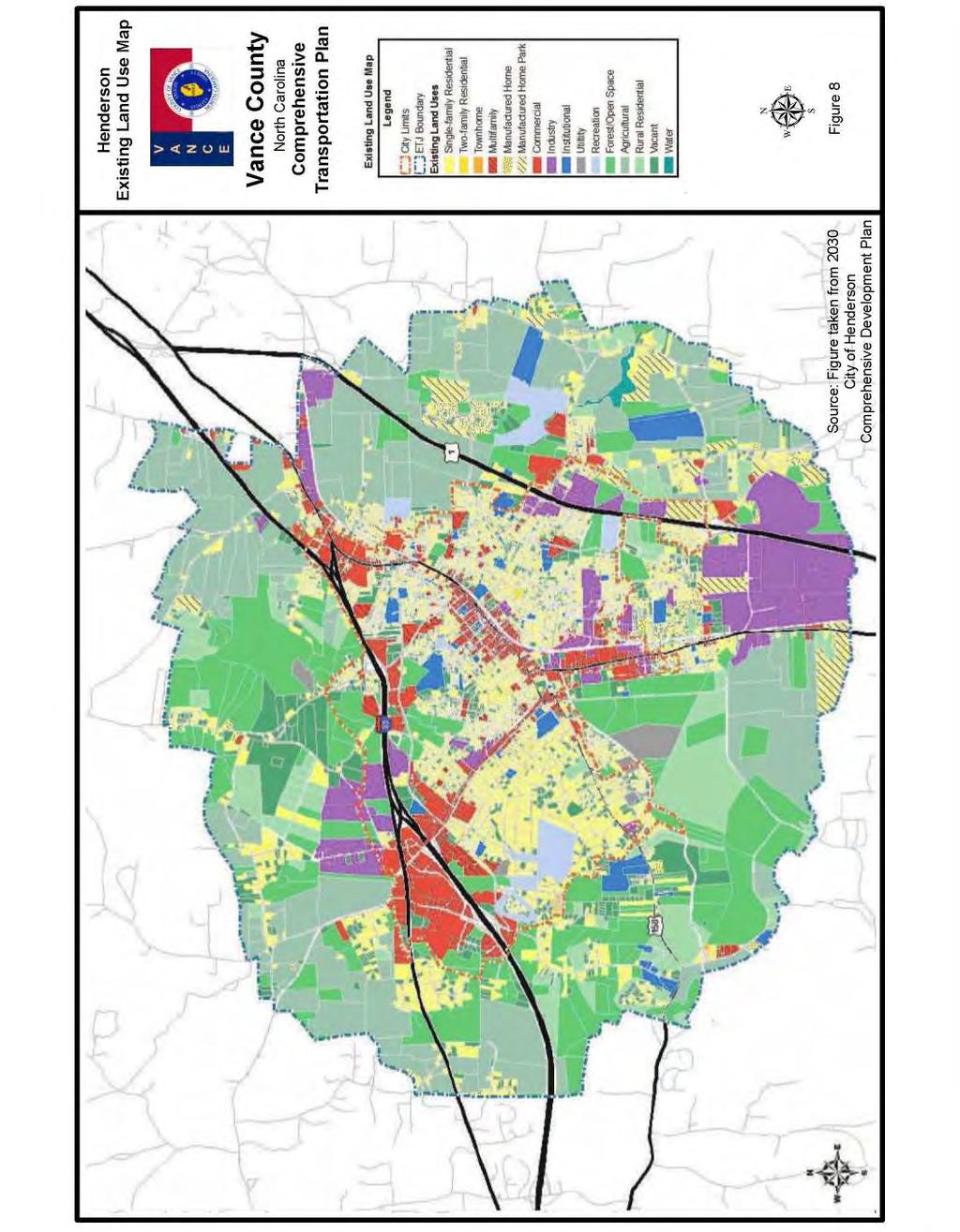
48 moutais to the coast of North Carolia. The Kerr-Tar Regioal Coucil of Govermets will be developig a regioal bike pla betwee Jue 2012 ad Jue 2014 that will recommed bicycle trasportatio coectios betwee the regio s lakes, tows, public lads, ad ladmarks withi the Kerr-Tar regio. All recommedatios for bicycle ad pedestria facilities were coordiated with the local govermets ad the NCDOT Divisio of Bicycle ad Pedestria Trasportatio. Refer to Appedix A for cotact iformatio. Lad Use G.S requires that local areas have a curret (less tha five years old) lad developmet pla prior to adoptio of the CTP. For this CTP, the 2010 Vace Couty Lad Use Pla, the 2007 Hederso Existig Lad Use Map ad the Hederso Future Lad Use Map (May 10, 2010) were used to meet this requiremet ad are illustrated i Figures 7, 8 ad 9, respectively. Lad use refers to the physical patters of activities ad fuctios withi a area. Traffic demad i a give area is, i part, attributed to adjacet lad use. For example, a large shoppig ceter typically geerates higher traffic volumes tha a residetial area. The spatial distributio of differet types of lad uses is a predomiat determiat of whe, where, ad to what extet traffic cogestio occurs. The travel demad betwee differet lad uses ad the resultig impact o traffic coditios varies depedig o the size, type, itesity, ad spatial separatio of developmet. Additioally, traffic volumes have differet peaks based o the time of day ad the day of the week. For trasportatio plaig purposes, lad use is divided ito the followig categories: Residetial: Lad devoted to the housig of people, with the exceptio of hotels ad motels which are cosidered commercial. Commercial: Lad devoted to retail trade icludig cosumer ad busiess services ad their offices; this may be further stratified ito retail ad special retail classificatios. Special retail would iclude high-traffic establishmets, such as fast food restaurats ad service statios; all other commercial establishmets would be cosidered retail. Idustrial: Lad devoted to the maufacturig, storage, warehousig, ad trasportatio of products. Public: Lad devoted to social, religious, educatioal, cultural, ad political activities; this would iclude the office ad service employmet establishmets. Agricultural: Lad devoted to the use of buildigs or structures for the raisig of o-domestic aimals ad/or growig of plats for food ad other productio. Mixed Use: Lad devoted to a combiatio of ay of the categories above. I-16
49 Aticipated future lad developmet is, i geeral, a logical extesio of the preset spatial lad use distributio. Locatios ad types of expected growth withi the plaig area help to determie the locatio ad type of proposed trasportatio improvemets. Vace Couty primarily aticipates growth i areas desigated as a Developmet Area icludig Towsville, Williamsboro, Gillburg, Hederso, Middleburg ad Kittrell as show i Figure 7. Developmet areas, as depicted i Figure 7, ecompass residetial, commercial ad public lad uses. These areas ted to be established populated areas ad are located throughout the Couty, typically alog major routes. I-17
50 This page itetioally left blak. I-18
51 Rd V I R G I N I A "$ 39 Rock Sprig Church (SR-1356) Rd K E R R L A K E Little Islad Creek Mor ga (S R-1 34 R Rd 2) ice Rd (SR-134 1) "$ 39 Rd Thomas (SR-1 329) Rd Jacksotow (SR-1369) GRANVILLE COUNTY Rd Hicksboro (SR-1303) Popular Creek Rd (SR-1126) Dabey Rd (SR-1304) Stagecoach BYP Rd d 158 BUS (SR-1326) Kelly (SR-1329) R o Wester Glebe Rd (SR-1308) H e d e r s o! 67! 28! 45 Outer Loop (SR-1295) "$ 39 Dr Dabey (SR-1162) Nutbush Rd (SR-1308) 1 BYP Carey Chapel lemigtow R d! 34! 89! 64! 30 Nutbush Creek! 27! ! 55 1! (SR-1519) (SR-1371) F Stewart Marti Creek (SR-1529) Warreto Rd (SR-1001) Farm Rd (SR-1518) Vicksboro 1 M i d d l e b u r g Fishig Creek Weaver Creek! 31! 52! 14! 32! 57! 36! 63 S a dy Creek Rd 158 (SR-1533) WARREN COUNTY S ho cc o Cr eek! 53 Iset A 1 Bear Pod Rd (SR-1115) Mill Rd Weldos 1 BYP "$ 39 Lybak Rd (SR-1115) Gillburg Rd (SR-1519) Charlie Gri sso m Rd (SR-1101) Tabbs Creek 1 K i t t r e l l FRANKLIN COUNTY # o Bridge Locatios (# Bridge Number) Schools Airports Roads Railroads Water Bodies Muicipal Boudary Couty Boudary Miles µ Figure 6 Base map date: Jauary 2011 Refer to CTP documet for more details Deficiet Bridges Vace Couty North Carolia Comprehesive Trasportatio Pla
52


53 Lad Use Map Vace Couty North Carolia Comprehesive Trasportatio Pla µ Source: Figure take from 2010 Vace Couty Lad Use Pla Figure 6
54
55 I-23
56 Back of Figure I-24
57 I-25
58 Back of Figure I-26
59 Cosideratio of Natural ad Huma Eviromet I recet years, the evirometal cosideratios have come to the forefrot of the trasportatio plaig process. Sectio 102 of the Natioal Evirometal Policy Act (NEPA) requires cosideratio of impacts o wetlads, wildlife, water quality, historic properties, ad public lads. While a full NEPA evaluatio was ot coducted as part of the CTP, potetial impacts to these resources were idetified as a part of the project recommedatios i Chapter 2 of this report. Prior to implemetig trasportatio recommedatios of the CTP, a more detailed evirometal study would eed to be completed i cooperatio with the appropriate evirometal resource agecies. A full listig of evirometal features that were examied as a part of this study is show i the followig tables utilizig the best available data. Evirometal features occurrig withi Vace Couty are show i Figure 10. Table 1 Evirometal Features Airport Boudaries Bike Routes (NCDOT) Colleges ad Uiversities Coservatio Tax Credit Properties Emergecy Operatio Ceters Federal Lad Owership Hazardous Substace Disposal Sites Hazardous Waste Facilities High Quality Water ad Outstadig Resource Water Maagemet Zoes Hospital Locatios Lad Trust Priority Areas Natioal Wetlads Ivetory Railroads (1:24,000 scale) Saitary Sewer Systems Discharges, Lad Applicatio Areas, Pipes, Pumps ad Treatmet Plats Schools Public ad No-Public State Parks Target Local Watersheds - EEP Water Distributio Systems Pipes, Pumps, Taks, Treatmet Plats, ad Wells Water Supply Watersheds Wild ad Sceic Rivers Additioally, the followig evirometal features were cosidered but are ot mapped due to restrictios associated with the sesitivity of the data. Table 2 Restricted Evirometal Features Archaeological Sites Historic Natioal Register Districts Historic Natioal Register Structures I-27 Macrosite Boudaries Maaged Areas Megasite Boudaries
60 This page itetioally left blak. I-28
61 GRANVILLE COUNTY V I R G I N I A!. WARREN COUNTY o v!.!?!?!? FRANKLIN COUNTY Emergecy Operatio Ceters!? Schools v Hospital Locatios o Airports!. Water Distributio Systems!. Saitary Sewer Systems Hazardous Waste Disposal Sites Roads Railroads Couty Boudary Natioal Wetlads Ivetory Federal Lad Owership Muicipal Boudary Water Supply Watersheds High Quality Water Zoes Target Local Watersheds Lad Trust Priority Areas Coservatio Tax Credit Properties Miles µ Figure 10 Base map date: Jauary 2011 Refer to CTP documet for more details Evirometal Features Vace Couty North Carolia Comprehesive Trasportatio Pla
62
63 Public Ivolvemet Public ivolvemet is a key elemet i the trasportatio plaig process. Adequate documetatio of this process is essetial for a seamless trasfer of iformatio from systems plaig to project plaig ad desig. The Kerr-Tar RPO requested the developmet of a comprehesive trasportatio pla for Vace Couty through a prioritized list of regioal eeds. A meetig was held with the Vace Couty Board of Commissioers i February 2011 to formally iitiate the study, provide a overview of the trasportatio plaig process, ad to gather iput o area trasportatio eeds. Throughout the course of the study, the Trasportatio Plaig Brach cooperatively worked with the Vace Couty Trasportatio Committee, which icluded a represetative from each muicipality, couty staff, the RPO ad others, to provide iformatio o curret local plas, to develop trasportatio visio ad goals, to discuss populatio ad employmet projectios, ad to develop proposed CTP recommedatios. Refer to Appedix H for detailed iformatio o the visio statemet, the goals ad objectives survey ad a listig of committee members. The public ivolvemet process icluded holdig two public drop-i sessios i Vace Couty to preset the proposed Comprehesive Trasportatio Pla to the public ad solicit commets. The first meetig was held o May 16, 2012 at the Kittrell Fire Departmet; the secod meetig was held o May 17, 2012 at the Kerr-Tar COG Office i Hederso. Each sessio was publicized i the local ewspaper ad was held from 4-7 pm. Additioally, otificatios were set out via lists to Vace Couty Schools ad the Kerr-Tar Coucil of Govermets. No commet forms were submitted durig these sessios. A public hearig was held o August 6, 2012 durig the Vace Couty Commissioers meetig, o August 27, 2012 durig the city of Hederso Commissioers meetig, o November 5, 2012 durig the tow of Kittrell Commissioers meetig ad o November 5, 2012 durig the tow of Middleburg Commissioers meetig. The purposes of these meetigs were to discuss the pla recommedatios ad to solicit further iput from the public. The CTP was adopted durig this meetig. The Kerr-Tar RPO edorsed the CTP o October 11, The North Carolia Departmet of Trasportatio mutually adopted the Vace Couty CTP o DATE. I-31
64 I-32
65 II. Recommedatios This report documets the developmet of the 2035 Vace Couty CTP as show i Figure 1. This chapter presets recommedatios for each mode of trasportatio i Vace Couty. Refer to Appedix I for documetatio of project alteratives ad scearios that were studied, but are ot icluded i the adopted CTP. Implemetatio The CTP is based o the projected growth for the plaig area. It is possible that actual growth patters will differ from those logically aticipated. As a result, it may be ecessary to accelerate or delay the implemetatio of some recommedatios foud withi this pla. Some portios of the pla may require revisios i order to accommodate uexpected chages i developmet. Therefore, ay chages made to oe elemet of the Comprehesive Trasportatio Pla should be cosistet with the other elemets. Iitiative for implemetig the CTP rests predomiately with the policy boards ad citizes of the Couty ad its muicipalities. As trasportatio eeds throughout the State exceed available fudig, it is imperative that the local plaig area aggressively pursue fudig for priority projects. Projects should be prioritized locally ad submitted to the Kerr-Tar RPO for regioal prioritizatio ad submittal to NCDOT. Refer to Appedix A for cotact iformatio o fudig. Local govermets may use the CTP to guide developmet ad protect corridors for the recommeded projects. It is critical that NCDOT ad local govermet coordiate o relevat lad developmet reviews ad all trasportatio projects to esure proper implemetatio of the CTP. Local govermets ad the North Carolia Departmet of Trasportatio share the resposibility for access maagemet ad the plaig, desig ad costructio of the recommeded projects. Prior to implemetig projects from the CTP, additioal aalysis will be ecessary to meet the Natioal Evirometal Policy Act (NEPA) or the North Carolia (or State) Evirometal Policy Act (SEPA). This CTP may be used to provide iformatio i the NEPA/SEPA process. The followig pages cotai problem statemets for each recommedatio, orgaized by CTP modal elemet. II-1
66 Problem Statemets The followig chapter cotais recommeded improvemets based o the ability of the existig system to serve curret ad aticipated travel volumes as the area cotiues to grow. The recommeded pla represets a system of trasportatio elemets icludig highway, rail, trasit, bicycle ad pedestria, which will serve the aticipated traffic ad lad developmet eeds for the Couty. The primary objective of this pla is to reduce traffic cogestio ad improve safety by elimiatig both existig ad projected deficiecies i the trasportatio system. HIGHWAY The recommeded highway improvemets are show o Figure 1 Sheets 2, 2A, ad 2B. The pla icludes roadways withi the plaig area that fall ito five categories: freeways, expressways, boulevards, other major thoroughfares, ad mior thoroughfares. See Appedix B for a more detailed descriptio of the differet facility types ad Appedix C for a roadway ivetory. Roadway properties, capacity deficiecies, evirometal impacts, ad lad use plas were cosidered whe developig recommedatios. The followig projects address capacity, mobility, coectivity ad safety deficiecies i Vace Couty. II-2
67 Uaddressed Deficiecies US 158 Busiess (Dabey Drive (SR 1162) to Mai Street) US 158 Busiess (Garett Street) is a 2-lae major thoroughfare that rus through the dowtow district of Hederso. The curret capacity of US 158 Busiess from Dabey Drive (SR 1162) to US 1 Busiess (Raleigh Road) is 10,000 vehicles per day (vpd) with 7,200 vpd i 2007 ad 9,200 vpd i US 158 Busiess from US 1 Busiess (Raleigh Road) to NC 39 (Adrews Aveue) has a curret capacity of 8,800 vpd with 8,200 vpd i 2007 ad 10,500 vpd i The curret capacity of US 158 Busiess from NC 39 to Mai Street is 10,000 vpd with 6,400 vpd i 2007 ad 8,200 vpd i Although this facility is expected to operate ear or over capacity i 2035, this deficiecy was ot addressed through the Comprehesive Trasportatio Pla (CTP) recommedatios sice there is o room for improvemet through the dowtow area of Hederso. Several historic structures such as the Hederso Fire Statio ad Zollicoffer s Law Office would be impacted if US 158 Busiess were wideed. There are also several historic districts alog US 158 Busiess that would be impacted if the facility were wideed. NC 39 (Piksto Street (SR 1214) to Chestut Street (SR 1226)) NC 39 from Garrett Road (SR 1538) to Piksto Street (SR 1214) is a 2-lae major thoroughfare that rus through a residetial area i Hederso. NC 39 is already over capacity from Piksto Street (SR 1214) to Chestut Street (SR 1226), with 14,000 vehicles per day (vpd) i 2007 ad a capacity of 11,800 vpd. The Comprehesive Trasportatio Pla (CTP) recommeds upgradig this facility to a 3-lae facility with bicycle ad pedestria accommodatios. This recommedatio will give the facility a capacity of 13,000 vpd which will ot accommodate the projected 21,800 vpd i 2035 but will provide safer accommodatios for bicyclists ad pedestrias. Approximately 50 homes ad 7 busiesses would be impacted if the facility were to be wideed to a 4- lae divided boulevard facility to accommodate the projected traffic i Completio of the Wester Outer Loop (SR 1295), improvemets to Dabey Drive (SR 1162) ad improvig the US 1/I-85 iterchage to accommodate all turig movemets could potetially help alleviate some of the traffic alog NC 39. II-3
68 II-4
69 US 1 Proposed Bypass from Beechtree Trail Road (SR 1104) to US 1 Busiess (Raleigh Road) Local ID: VANC0003-H Last Updated: 01/17/11 VANC0003-H IDENTIFIED PROBLEM Existig US 1 from Beechtree Trail Road (SR 1104) to US 1 Busiess (Raleigh Road) is curretly a 5-lae, udivided facility that does ot meet the mobility goals of North Carolia s Strategic Highway Corridor Visio Pla. The primary purpose of improvig US 1 is to meet North Carolia s Strategic Highway Corridor Visio for mobility ad coectivity. Justificatio of Need US 1 is a major orth-south US highway that rus for 2,377 miles from Maie to Florida. This facility is a vital artery i movig people ad goods through North Carolia, coectig major urba areas, such as Raleigh Project Locatio ear Kittrell ad Cary, ad ultimately coectig Virgiia to South Carolia. US 1 is o the statewide tier of the North Carolia Multimodal Ivestmet Network (NCMIN) ad is also part of the Strategic Highway Corridor (SHC) Visio Pla as a freeway that eeds improvemet. US 1 is curretly a 5-lae major thoroughfare from Beechtree Trail Road (SR 1104) to US 1 Busiess with a speed limit of miles per hour (mph) ad does ot meet the Strategic Highway Corridor Visio Pla for mobility ad coectivity. From Beechtree Trail Road (SR 1104) to Kittrell College Road (SR 1105), US 1 has a existig capacity of 33,000 vehicles per day (vpd) ad a estimated 16,600 vpd i From Kittrell II-5
70 College Road (SR 1105) to US 1 Busiess (Raleigh Road), US 1 has a existig capacity of 33,000 vpd ad a estimated 22,100 vpd i Commuity Visio ad Problem History The US 1 proposed project would be cosistet with the visio ad mobility goals developed by the Vace Couty CTP Committee to esure the itegrity of the existig trasportatio system by ecouragig itegrated lad use ad trasportatio plaig that serves existig developmet, supports future developmet, ad is cosistet with the Couty lad use pla for preservig the atural eviromet ad commuity character ad preservig the rural character of the Couty while accommodatig growth to targeted areas. CTP PROJECT PROPOSAL Project Descriptio ad Overview The CTP proposed project (Local ID: VANC0006-H) is to provide a bypass facility from Beechtree Trail Road (SR 1104) to US 1 Busiess (Raleigh Road). A grade separatio at Kittrell College Road (SR 1105) is recommeded. Existig US 1 from Beechtree Trail Road (SR 1104) to US 1 Busiess (Raleigh Road) is curretly a 5-lae udivided facility but is recommeded to have a media barrier istalled (TIP Project W-5317). This CTP proposed project would allow through traffic to move aroud the tow of Kittrell without havig to use the lower speed limit through the tow, ad disruptig adjacet lad use. Natural ad Huma Evirometal Cotext I the developmet of the Vace Couty CTP, three optios were cosidered for US 1 from Beechtree Trail Road (SR 1104) to US 1 Busiess (Raleigh Road). A wester bypass was chose for improvig US 1, sice the potetial huma ad evirometal impacts would be higher if the existig was to be wideed or a easter bypass costructed. The selected CTP alterative miimizes the impacts to homes, busiesses, ad evirometal features ad will cross three wetlads. Kittrell Sprigs is the historical site of North Carolia s first summer resort ad is located o the west side of Kittrell which rus earby to the proposed bypass ad should be ivestigated further util a fial aligmet is selected. Refer to Appedix I for the additioal alteratives studied but ot selected. Relatioship to Lad Use Plas The existig Vace Couty Lad Use Pla shows developmet commuities alog the proposed ew locatio for US 1 aroud Kittrell. The CTP proposal for a 4-lae freeway II-6
71 facility will allow Vace Couty to develop i a maer cosistet with their lad use map. The CTP proposal for a bypass facility aroud Kittrell would esure that the tow is ot split i half by a expasio of existig US 1 ad would provide efficiet ad safe access that is cosistet with the mobility goals of the Strategic Highway Corridor Visio. Likages to Other Plas ad Proposed Project History The proposal directly coects to the recommedatio for US 1 (VANC0005-H) from the Frakli Couty Lie to Beechtree Trail Road (SR 1104) to upgrade the facility to a 4- lae divided freeway. US 1 s proposal is cosistet with Vace Couty s Visio ad Goals Statemet developed by the committee to guide the CTP study to support existig developmet patters ad evirometal sesitivity. Refer to Appedix H for the Visio ad Goals Statemet. Also see Appedix I for other alteratives cosidered for this proposal. Multi-modal Cosideratios The CTP does ot iclude ay multi-modal recommedatios for bicycle, pedestria or public trasportatio facilities alog the proposed US 1 Bypass from Beechtree Trail Road (SR 1104) to US 1 Busiess (Raleigh Road). Public/Stakeholder Ivolvemet NCDOT TPB ad the Kerr-Tar RPO met with the tow of Kittrell o February 6, 2012 to discuss the proposed bypass recommedatio which was met with full support. No commets cocerig this proposal were received durig the public drop-i sessios held o May 15 ad 16 from 4-7 pm. II-7
72 II-8
 from US 158 Busiess to I-85 is curretly over capacity i most sectios with 12,000 to 29,000 vehicles per day (vpd) i 2007 ad a capacity of 14,400 to 28,900 vpd.")
 is a importat orth-south corridor i the city of Hederso ad is a vital coector betwee US 158 Busiess, US 158 Bypass, US 1 Busiess (Raleigh Road) ad I-85.")
73 Dabey Drive (SR 1162) Proposed Improvemets from US 158 Busiess to I-85 Local ID: VANC0013-H Last Updated: 06/06/12 VANC0013-H Project Locatio withi Hederso Existig Dabey Drive IDENTIFIED PROBLEM Existig Dabey Drive (SR 1162) from US 158 Busiess to I-85 is curretly over capacity i most sectios with 12,000 to 29,000 vehicles per day (vpd) i 2007 ad a capacity of 14,400 to 28,900 vpd. The primary purpose of improvig Dabey Drive (SR 1162) is to relieve cogestio o the existig facility such that a Level of Service (LOS) D ca be achieved. Justificatio of Need Dabey Drive (SR 1162) is a importat orth-south corridor i the city of Hederso ad is a vital coector betwee US 158 Busiess, US 158 Bypass, US 1 Busiess (Raleigh Road) ad I-85. This facility is expected to cotiue experiecig growth ad is a major roadway servig Northwest Hederso ad the Cetral Busiess District (CBD). This sectio of Dabey Drive (SR 1162) serves a school, may commercial busiesses ad several residetial commuities. Dabey Drive (SR 1162) is curretly a major thoroughfare (4-lae cross sectio) from US 158 Busiess (Oxford Road) to US 158 Busiess (Garett Street), a mior thoroughfare (3-lae cross sectio) from US 158 Busiess (Garett Street) to Coble Boulevard, ad a major thoroughfare (5-lae cross sectio) from Coble Boulevard to I- 85 with a speed limit of 35 miles per hour (mph). II-9
74 Sectio (From To) 2007 AADT (vpd) 2035 AADT (vpd) Curret Capacity (vpd) US 158 Busiess (Oxford Road) US 158 Busiess (Garett Street) 12,000 15,400 21,000 US 158 Busiess (Garett Street) Roaoke Aveue 15,000 19,200 14,400 Roaoke Aveue Coble Boulevard 21,000 26,700 14,400 Coble Boulevard I-85 29,000 43,000 49,200 Commuity Visio ad Problem History While the commuity evisios a trasportatio etwork that improves safety ad cogestio, the curret levels of cogestio alog Dabey Drive (SR 1162) make access difficult for residets ad visitors. Dabey Drive (SR 1162) is ot coducive for bicyclists ad pedestrias ad does ot follow the commuity s goal to promote roadways that allow ad ecourage alterative modes of trasportatio such as trasit, walkig ad bikig. Durig the 2011 CTP public survey, Dabey Drive (SR 1162) was idetified as the umber oe problem for safety, cogestio ad truck traffic (see Appedix H). Four high crash locatios were idetified alog Dabey Drive (SR 1162) durig the traffic crash aalysis betwee the time period of Jauary 1, 2007 ad December 31, 2009 ad ca be see i the table below: Itersectio Crashes Severity Idex Dabey Drive (SR 1162) Coble Boulevard Dabey Drive (SR 1162) Cooper Drive Dabey Drive (SR 1162) Beckford Drive (SR 1165) Dabey Drive (SR 1162) I Dabey Drive (SR 1162) was also idetified i the 1995 Hederso Thoroughfare Pla from US 158 Busiess (Oxford Road) to I-85 as beig over capacity but o recommedatios were made. CTP PROJECT PROPOSAL Project Descriptio ad Overview The CTP proposed project (Local ID: VANC0013-H) is to provide a oe-way pair facility (2-laes each directio) from US 158 Busiess (Oxford Road) to Cooper Drive with II-10
75 Dabey Drive (SR 1162), Corbitt Road ad the abadoed rail corridor ad a 6-lae boulevard facility from Cooper Drive to I-85. Dabey Drive (SR 1162) will carry southboud traffic while Corbitt Road ad the extesio o the abadoed rail corridor will carry orthboud traffic. The CTP proposal recommeds removig the existig offset for US 158 Busiess as well as startig the souther termii of the oe-way pair at US 158 Busiess (Garett Street). A slip lae ear US 158 Busiess (Garett Street) is recommeded to coect Dabey Drive (SR 1162) ad Corbitt Road to allow the fire statio access to both the orthboud ad southboud traffic laes. The existig coectios betwee Dabey Drive (SR 1162) ad Corbitt Road are recommeded to remai at Bae Aveue, Parham Street, Yadki Street, Roaoke Aveue, ad Coble Boulevard, although istead of full movemet, they may be coverted to right-i/right-out. Covertig Dabey Drive (SR 1162), Corbitt Road ad the abadoed rail corridor ito a oe-way pair will chage the capacity of the facility as show i the table below. This proposal will alleviate the curret capacity issues ad will also be able to hadle the estimated 15,400 to 26,700 vpd i Sectio (From To) Curret Capacity (vpd) Proposed Capacity (vpd) US 158 Busiess (Oxford Road) US 158 Busiess (Garett Street) 21,000 32,600 US 158 Busiess (Garett Street) Roaoke Aveue 14,400 32,600 Roaoke Aveue Coble Boulevard 14,400 32,600 Coble Boulevard I-85 28,900 49,200 Project phasig should be cosidered for this Dabey Drive (SR 1162) recommedatio (VANC0013-H) ad may progress as show below. 1. Wide bridge with I-85 ad costruct media ad ew laes betwee Cooper Drive ad I Exted Corbitt Road o ew locatio betwee Parham Street ad Cooper Drive with bicycle ad pedestria accommodatios. 3. Realig itersectio with US 158 Busiess (Oxford Road/Garett Street) area ad resurface/restripe Dabey Drive (SR 1162) from US 158 Busiess (Oxford Road) to Cooper Drive to covert to a oe-way facility. Sidewalks ad bike laes are recommeded from US 158 Busiess (Oxford Road) to Cooper Drive. Sidewalks ad wide outside laes to accommodate bicycles are II-11
76 recommeded from Cooper Drive to I-85. A multi-use path usig the old railroad bridge is recommeded alog Dabey Drive from Beckford Drive (SR 1165) to Exchage Street. Natural ad Huma Evirometal Cotext I the developmet of the Vace Couty CTP, two optios were cosidered for improvig traffic flow alog Dabey Drive (SR 1162), which icluded wideig existig or a oe-way pair facility usig Dabey Drive (SR 1162), Corbitt Road ad the abadoed rail corridor. A oe-way pair was chose for improvig Dabey Drive (SR 1162), due to potetial huma impacts to busiesses ad residets if the existig facility were to be wideed. The selected CTP alterative miimizes the impacts to homes, busiesses, ad evirometal features. Refer to Appedix I for the additioal alterative cosidered but ot icluded i the CTP. Relatioship to Lad Use Plas The existig city of Hederso Lad Use Pla shows commercial, istitutioal, residetial, ad idustry lad uses alog this sectio of Dabey Drive (SR 1162). The future city of Hederso Lad Use Pla as see i Figure 8 shows mixed use commuity ad urba desity alog Dabey Drive (SR 1162). The CTP proposal for a oe-way pair facility (2 laes each directio) from US 158 Busiess (Oxford Road) to Cooper Drive ad a 6-lae boulevard facility from Cooper Drive to I-85 will allow Hederso to develop i a maer cosistet with their lad use map. A oe-way pair/6-lae boulevard facility would elimiate may left turs with more right-i/right out tur movemets ad provide more efficiet ad safe access to Dabey Drive (SR 1162). Likages to Other Plas ad Proposed Project History I the 1995 Hederso Thoroughfare Pla, Dabey Drive (SR 1162) was idetified as havig capacity issues from US 158 Busiess (Oxford Road) to I-85 but o recommedatios were made. The Dabey Drive (SR 1162) proposal directly coects to the recommedatio for the Dabey Drive Extesio (SR 1267) to coect it to Alexader Aveue (VANC0015-H) due to the proposed Southeast High Speed Rail (VANC0001-R) ad to the proposal for Dabey Drive (VANC0014-H) from I-85 to US 158 Bypass to upgrade this facility to a 6-lae boulevard facility. The Dabey Drive (SR 1162) proposal is cosistet with Vace Couty s Visio ad Goals Statemet developed by the committee to guide the CTP study. Refer to Appedix H for the Visio ad Goals Statemet. This oe-way pair/6-lae boulevard recommedatio is cosistet with may of the goals icludig evirometal II-12
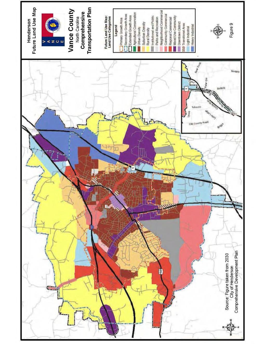
77 sesitivity, supportig existig developmet patters, improvig safety ad cogestio, ad ecouragig alterative modes of trasportatio. Multi-modal Cosideratios The CTP icludes recommedatios for bicycle, pedestria ad public trasportatio facilities aroud the city of Hederso. Sidewalks ad bike laes are recommeded alog Dabey Drive (SR 1162) from US 158 Busiess to Cooper Drive. Sidewalks ad wide outside laes to accommodate bicycles are recommeded alog Dabey Drive (SR 1165) from Cooper Drive to US 158 Bypass. A multi-use path is recommeded alog Dabey Drive (SR 1162) from Beckford Drive (SR 1165) to Exchage Street ad ca be see o Sheets 4 ad 4A of Figure 1. Pedestria sigals are recommeded at Parham Street, Bae Aveue ad Coble Boulevard to icrease pedestria safety alog this corridor. The multi-modal facilities alog Dabey Drive (SR 1162) do ot sigificatly impact the traffic demad alog this corridor. I additio, the Aroud Tow Shuttle curretly travels alog Dabey Drive (SR 1162) from Parker Lae to Rui Creek Road (SR 1128) but does ot reduce the eed to improve Dabey Drive (SR 1162) from I-85 to US 158 Bypass. Public/Stakeholder Ivolvemet The iitial oe-way pair/6-lae boulevard recommedatio for Dabey Drive (SR 1162) was preseted to the Vace Couty CTP Committee durig the August 16, 2011 meetig ad was received with full support. The oe-way pair cocept was preseted to the city of Hederso o October 10, 2011 ad the city agreed that this was a cocept to study further. Oe public commet received at the October 10, 2011 meetig was a cocer for the residets that live i betwee Dabey Drive (SR 1162) ad Corbitt Road ad the impact of havig traffic flow i the frot ad back yards of their houses. No commets were received for this proposal durig the public drop-i sessios held o May 15 ad 16 from 4-7 pm. II-13
78 II-14
 from I-85 to US 158 Bypass is curretly earig capacity with 21,000 vehicles per day (vpd) i 2007 ad a capacity of 28,900 vpd.")
 is a importat orth-south corridor i the city of Hederso ad is a vital coector betwee US 158 Busiess, US 158 Bypass, US 1 Busiess (Raleigh Road) ad I-85.")
79 Dabey Drive (SR 1162) Proposed Improvemets from I-85 to US 158 Bypass Local ID: VANC0014-H Last Updated: 04/05/12 VANC0014-H Project Locatio withi Hederso Existig Dabey Drive IDENTIFIED PROBLEM Existig Dabey Drive (SR 1162) from I-85 to US 158 Bypass is curretly earig capacity with 21,000 vehicles per day (vpd) i 2007 ad a capacity of 28,900 vpd. The primary purpose of improvig Dabey Drive (SR 1162) is to relieve cogestio o the existig facility such that a Level of Service (LOS) D ca be achieved. Justificatio of Need Dabey Drive (SR 1162) is a importat orth-south corridor i the city of Hederso ad is a vital coector betwee US 158 Busiess, US 158 Bypass, US 1 Busiess (Raleigh Road) ad I-85. It is expected to cotiue experiecig growth ad is a major roadway servig Hederso ad the Cetral Busiess District (CBD). This sectio of Dabey Drive (SR 1162) serves commercial busiesses. This sectio of Dabey Drive (SR 1162) is curretly a major thoroughfare (5-lae cross sectio) with a speed limit of 35 miles per hour (mph). The sectio of Dabey Drive (SR 1162) from I-85 to US 158 Bypass is curretly earig capacity with 21,000 vpd ad a existig capacity of 28,900 vpd ad is aticipated to have 32,500 vpd i Commuity Visio ad Problem History While the commuity evisios a trasportatio etwork that improves safety ad cogestio, the curret levels of cogestio make access difficult for residets ad visitors. Dabey Drive (SR 1162) is ot coducive for bicyclists ad pedestrias ad II-15
80 does ot follow the Visio ad Goals developed by the Vace Couty CTP Committee to promote roadways that allow ad ecourage alterative modes of trasportatio such as trasit, walkig ad bikig. Durig the 2011 CTP public survey, Dabey Drive (SR 1162) was idetified as the umber oe problem for safety, cogestio ad truck traffic. Two crash locatios were idetified alog Dabey Drive (SR 1162) durig the traffic crash aalysis betwee the time period of Jauary 1, 2007 ad December 31, 2009 ad ca be see i the table below: Itersectio Crashes Severity Idex Dabey Drive (SR 1162) US 158 Bypass Dabey Drive (SR 1162) I CTP PROJECT PROPOSAL Project Descriptio ad Overview The CTP proposed project (Local ID: VANC0014-H) is to provide a 6-lae, boulevard facility alog Dabey Drive (SR 1162) from I-85 to US 158 Bypass. Covertig Dabey Drive (SR 1162) ito a boulevard will chage the capacity of the facility from 28,900 vpd to 47,700 vpd ad will also provide for better cotrol of access. This proposal will alleviate the curret capacity issues ad will also be able to hadle the estimated 32,500 vpd i Sidewalks ad shared bike laes are recommeded alog Dabey Drive (SR 1162) from I-85 to US 158 Bypass. A multi-use path that uses the existig rail bridge is recommeded from Beckford Drive (SR 1165) to Exchage Street. Natural ad Huma Evirometal Cotext I the developmet of the Vace Couty CTP, two optios were cosidered for improvig traffic flow alog Dabey Drive (SR 1162) from I-85 to US 158 Bypass. A 6- lae, boulevard facility was chose for improvig Dabey Drive (SR 1162) due to the miimal impacts it will have to the atural ad huma eviromets. The selected CTP alterative miimizes the impacts to homes, busiesses, ad evirometal features. The other alterative that was studied is documeted i Appedix I. II-16
81 Relatioship to Lad Use Plas The existig city of Hederso 2030 Comprehesive Developmet Pla shows commercial lad uses alog this sectio of Dabey Drive (SR 1162). The future city of Hederso Lad Use Pla as see i Figure 8 shows regioal commercial alog this sectio of Dabey Drive (SR 1162). The CTP proposal for a 6-lae, boulevard facility from I-85 to US 158 Bypass will allow Hederso to develop i a maer cosistet with their lad use map. A boulevard facility would elimiate may left turs with more right-i/right out tur movemets ad provide more efficiet ad safe access to Dabey Drive (SR 1162). Likages to Other Plas ad Proposed Project History I the 1995 Hederso Thoroughfare Pla, Dabey Drive (SR 1162) was idetified as beig over capacity but o recommedatios were made. The Dabey Drive (SR 1162) proposal directly coects to the recommedatio for I-85 to wide to a 6-lae, divided facility (VANC0001-H). This sectio of Dabey Drive (SR 1162) also coects to the proposal (VANC0013-H) for Dabey Drive (SR 1162) to upgrade the facility to a 6-lae boulevard facility from Beckford Drive (SR 1165) to I-85. The proposal for Dabey Drive (SR 1162) is cosistet with Vace Couty s Visio ad Goals Statemets developed by the committee to guide the CTP study. Refer to Appedix H for the Visio ad Goals Statemet. This 6-lae boulevard recommedatio is cosistet with may of the goals icludig evirometal sesitivity, supportig existig developmet patters, improvig safety ad cogestio, ad ecouragig alterative modes of trasportatio. Multi-modal Cosideratios The CTP icludes recommedatios for bicycle, pedestria ad public trasportatio facilities aroud the city of Hederso. Sidewalks ad wide outside laes for bicycles are recommeded alog Dabey Drive (SR 1162) from I-85 to US 158 Bypass ad ca be see o Sheets 4 ad 4A of Figure 1. The multi-modal facilities alog Dabey Drive (SR 1162) do ot sigificatly impact the traffic demad alog this corridor. I additio, the Aroud Tow Shuttle curretly travels alog Dabey Drive (SR 1162) from Parker Lae to Rui Creek Road (SR 1128) but does ot reduce the eed to improve Dabey Drive (SR 1162) from I-85 to US 158 Bypass. Public/Stakeholder Ivolvemet The recommedatio for this sectio of Dabey Drive (SR 1162) was preseted to the Vace Couty CTP Committee durig the August 16, 2011 meetig ad was received with full support. The proposal was preseted to the city of Hederso o October 10, II-17
82 2011 ad the City agreed that this was defiitely somethig to look ito further. Oe public commet received at the October 10, 2011 meetig was a cocer for the residets that live i betwee Dabey Drive (SR 1162) ad Corbitt Road ad the impact of havig traffic flow i frot ad behid their houses. No commets were received for this proposal durig the public drop-i sessios held o May 15 ad 16 from 4-7 pm. II-18
83 Wester Outer Loop (SR 1295) Extesio from Old Couty Home Road (SR 1101) to US 1 Bypass Local ID: VANC0028-H Last Updated: 01/30/12 VANC0028-H Project Locatio of Recommeded Wester Outer Loop IDENTIFIED PROBLEM The Wester Outer Loop (SR 1295), which is curretly icomplete, does ot provide for the aticipated growth i the area, or does it alleviate the through traffic which cotributes to the capacity issues already see o Dabey Drive (SR 1162). The completed sectio of the Wester Outer Loop (SR 1295) curretly rus from Rui Creek Road (SR 1128) to Old Couty Home Road (SR 1101) ad the remaider of the proposed Wester Outer Loop (SR 1295) will ru from Old Couty Home Road (SR 1101) to US 1 Bypass. This project is i the Trasportatio Improvemet Program (TIP) but does ot have a project umber because it did ot rak high eough to receive fudig ad is scheduled for reprioritizatio. The primary purpose of extedig the Wester Outer Loop (SR 1295) is to relieve the cogestio created by the through traffic o existig Dabey Drive (SR 1162) ad US 1 Busiess as well as providig for the expected growth ad developmet of Hederso. Justificatio of Need The completed Wester Outer Loop (SR 1295) will be a importat orth-south corridor i the wester part of the city of Hederso ad is a vital coector betwee I-85, US 158 Bypass, US 158 Busiess, US 1 Busiess ad US 1 Bypass. Dabey Drive (SR 1162) is expected to cotiue experiecig growth ad the Wester Outer Loop (SR 1295), whe completed, will be a major roadway servig wester Hederso. The Wester Outer Loop (SR 1295) serves mostly commercial ad residetial properties. The Wester Outer Loop (SR 1295) curretly rus from Rui Creek Road (SR 1128) to Old Couty Home Road (SR 1101) ad is curretly a 4-lae, boulevard facility with a speed limit of 55 miles per hour (mph). That sectio has a existig capacity of 25,800 vpd ad is aticipated to have 11,600 vpd i Dabey Drive (SR 1162) is already over capacity from US 158 Busiess to I-85 ad US 1 Busiess is already over or earig capacity from US 1 Bypass to Old Couty Home Road (SR 1101). II-19
84 Commuity Visio ad Problem History While the commuity evisios a trasportatio etwork that improves safety ad cogestio, the curret levels of cogestio alog Dabey Drive (SR 1162) makes access difficult for residets ad visitors. The existig Wester Outer Loop (SR 1295) is icomplete ad does ot serve its iteded purpose to relieve the cogestio created by the through traffic o existig Dabey Drive (SR 1162) as well as providig for the expected growth ad developmet of Hederso. Completig the Wester Outer Loop (SR 1295) is cosistet with the Visio ad Goals Statemets developed by the Vace Couty CTP Committee to develop a trasportatio etwork that improves safety ad cogestio. Durig the 2011 CTP public survey, several respodets aswered that they wated the Wester Outer Loop (SR 1295) completed. Oe crash locatio was idetified alog the Wester Outer Loop (SR 1295) durig the traffic crash aalysis betwee the time period of Jauary 1, 2007 ad December 31, 2009 at the itersectio of US 158 Busiess ad had 10 crashes ad a severity idex of CTP PROJECT PROPOSAL Project Descriptio ad Overview The CTP proposed project (Local ID: VANC0031-H) for the Wester Outer Loop (SR 1295) is to provide a 2-lae, mior thoroughfare o multi-lae right of way o ew locatio extedig it from Old Couty Home Road (SR 1101) to US 1 Bypass. The Wester Outer Loop (SR 1295) will travel o ew locatio from Old Couty Home Road (SR 1101) to Leo Frazier Road (SR 1116) ad will coect with the existig Leo Frazier Road (SR 1116) ad Lybak Road (SR 1115) util it reaches US 1 Bypass. Completig the Wester Outer Loop (SR 1295) with a 2-lae mior thoroughfare will relieve cogestio alog Dabey Drive (SR 1295) which is curretly over capacity i some sectios. Natural ad Huma Evirometal Cotext I the developmet of the Vace Couty CTP, the chose Wester Outer Loop (SR 1295) recommedatio is cosistet with the 1995 Hederso Thoroughfare Pla. A 2- lae, mior thoroughfare from Old Couty Home Road (SR 1101) to US 1 Bypass was recommeded for completig the Wester Outer Loop (SR 1295). This recommedatio will have 2 stream crossigs ad will also hit a high quality water zoe where it travels alog existig North Lybak Road (SR 1115)/Bear Pod Road (SR 1115) but should have oly mior, if ay impacts to this area. II-20
85 Relatioship to Lad Use Plas The existig city of Hederso Lad Use Pla shows commercial, residetial ad ope space lad uses i this area. The future city of Hederso Lad Use Pla as see i Figure 8 shows regioal commercial ad rural desity alog the existig ad proposed Wester Outer Loop (SR 1295). The CTP proposal for a 2-lae, mior thoroughfare from Old Couty Home Road (SR 1101) to US 1 Bypass will allow Hederso to develop i a maer cosistet with their lad use map. A mior thoroughfare completig the Wester Outer Loop (SR 1295) would reduce cogestio alog Dabey Drive (SR 1162) ad will provide for the expected growth ad developmet of Hederso. Likages to Other Plas ad Proposed Project History I the 1995 Hederso Thoroughfare Pla, the Wester Outer Loop (SR 1295) was recommeded as a 4-lae boulevard from Bear Pod Road (SR 1115) to Rui Creek Road (SR 1128) with the portio from Rui Creek Road (SR 1128) to Belmot Drive (SR 1101) beig programmed i the TIP (U-2527). The reasoig for this recommedatio was to provide for circumferetial travel movemets i the wester sectios of Hederso, provide for the expected growth ad developmet, ad also to relieve cogestio created by through traffic o existig Dabey Drive (SR 1162). The recommedatio i the Vace Couty CTP differs slightly from that of the 1995 Hederso Thoroughfare Pla i that the Wester Outer Loop (SR 1295) eds at the US 1 Bypass istead of NC 39. The Wester Outer Loop (SR 1295) proposal is cosistet with Vace Couty s Visio ad Goals Statemets developed by the committee to guide the CTP study. Refer to Appedix H for the Visio ad Goals Statemet. This 2-lae mior thoroughfare recommedatio is cosistet with the goal to develop a trasportatio etwork that improves safety ad cogestio. Multi-modal Cosideratios The CTP icludes recommedatios for wide outside bike laes oly alog the existig portio of the Wester Outer Loop (SR 1295) ad is show o Figure 1, Sheets 4 ad 4A. This recommedatio does ot sigificatly impact the traffic demad alog this corridor. Public/Stakeholder Ivolvemet No commets o this proposal were received durig the public drop-i sessios held o May 15 ad 16 from 4-7 pm. II-21
86 II-22
87 I-85 from Graville Couty Lie to Warre Couty Lie, Local ID: VANC0001-H I-85 is a major east-west corridor i Vace Couty that rus alog the orth side of Hederso, coectig to major destiatios i North Carolia such as Durham ad other muicipalities outside the state like Virgiia ad South Carolia. This facility is a vital artery i movig people ad goods through North Carolia, coectig major urba areas, such as Durham ad Greesboro, ad ultimately coectig Virgiia to South Carolia. I-85 is o the statewide tier of the North Carolia Multimodal Ivestmet Network (NCMIN) ad is also part of the Strategic Highway Corridor (SHC) Visio Pla as a existig freeway. The primary purpose of improvig I-85 is to relieve cogestio due to capacity deficiecies o the existig facility such that a miimum Level of Service (LOS) D ca be achieved. The curret (2007) ad estimated (2035) vehicles per day (vpd) alog with the curret capacity for each sectio of the facility ca be see i the table below. Sectio (From To) 2007 AADT (vpd) 2035 AADT (vpd) Curret Capacity (vpd) Graville Couty Lie US 1 Bypass 32,000 58,900 60,000 US 1 Bypass US 158 Busiess 27,000 49,700 60,000 US 158 Busiess Rui Creek Road (SR 1128) 35,000 64,000 60,000 Rui Creek Road (SR 1128) Warre Couty Lie 31,000 57,000 60,000 The proposed Comprehesive Trasportatio Pla (CTP) project recommeds upgradig I-85 from the Graville Couty Lie to the Warre Couty Lie to a 6-lae divided freeway facility. Additioally, the Rui Creek Road (SR 1128) ad Dabey Drive (SR 1162) iterchages will eed to be redesiged to meet freeway iterchage spacig stadards. Existig I-85 iterchages at Rui Creek Road (SR 1128) ad Dabey Drive (SR 1162) are curretly oly 0.8 miles apart ad a split diamod iterchage is recommeded. It was metioed i the Hederso 1995 Thoroughfare Pla that I-85 would be earig capacity i The curret Graville ad Warre Couty CTPs recommed I-85 be wideed to a 6-lae divided freeway facility throughout their respective couties. I-85 Service Road from Poplar Creek Road (SR 1126) to Wester Outer Loop (SR 1295), Local ID: U-3836 The proposed project (U-3836) is to provide a 2-lae service road o ew locatio south of I-85 ad tyig ito Rui Creek Road (SR 1128) at Graham Aveue (SR 1218). This recommedatio would provide trasportatio ifrastructure to support commuity growth ad developmet as well as relieve some local traffic from I-85. II-23
88 For additioal iformatio about this project, icludig the purpose ad eed, cotact NCDOT PDEA. I-85/US 1 Bypass Iterchage, Local ID: I-3812 The existig I-85/US 1 Bypass iterchage does ot accommodate all turig movemets. Cocers have bee expressed by the tow regardig truck traffic throughout the dowtow streets of Hederso due to the lack of turig movemets at the existig iterchage. Idustrial ad commercial truck traffic comig from the west i the Poplar Creek area as well as Oxford i Graville Couty must travel through the dowtow streets of Hederso because of the limited turig movemets at the I- 85/US 1 Bypass iterchage. The proposed project (I-3812) is to modify the existig iterchage to accommodate all turig movemets for the I-85 ad US 1 Bypass. This proposal could reduce traffic i the dowtow streets of Hederso ad help with some of the existig cogestio issues i city by providig turig movemets from I-85 orth oto US 1 Bypass south as well as turig movemets from US 1 Bypass orth to I-85 south. Both the 1995 Hederso Thoroughfare Pla ad the 1995 Vace Couty Thoroughfare Pla recommeds the I-85/US 1 Bypass be redesiged to accommodate all turig movemets. For additioal iformatio about this project, icludig the purpose ad eed, cotact NCDOT PDEA. US 1 from Frakli Couty Lie to Beechtree Trail Road (SR 1104), Local ID: VANC0002-H The primary purpose of improvig US 1 is to meet North Carolia s Strategic Highway Corridor Visio for mobility ad coectivity. US 1 is curretly a 4-lae divided facility with partial cotrol of access from the Frakli Couty Lie to Beechtree Trail Road (SR 1104). The Comprehesive Trasportatio Pla (CTP) recommeds upgradig US 1 from the Frakli Couty Lie to Beechtree Trail Road (SR 1104) to a 4-lae freeway with full cotrol of access. This recommedatio will icrease the capacity of US 1 from 45,200 vpd to 59,900 vpd. US 1 is a major orth-south US highway that rus for 2,377 miles from Maie to Florida. This facility is a vital artery i movig people ad goods through North Carolia, coectig major urba areas, such as Raleigh ad Cary, ad ultimately coectig Virgiia to South Carolia. US 1 is o the statewide tier of the North Carolia Multimodal Ivestmet Network (NCMIN) ad is also part of the Strategic Highway II-24
89 Corridor (SHC) Visio Pla as a freeway that eeds improvemet. Existig US 1 is ot aticipated to have ay capacity issues with 13,000 vehicles per day (vpd) i 2007 ad a capacity of 45,200 vpd. US 1 from Wall Road (SR 1135) to US 1 Busiess, Local ID: W-5317 TIP Project W-5317 recommeds istallig a media barrier for safety alog US 1 from Wall Road (SR 1135) i Frakli Couty to US 1 Busiess i Vace Couty. For additioal iformatio about this project, icludig the purpose ad eed, cotact NCDOT PDEA. US 1 Busiess (Raleigh Road) from Peter Gill Road (SR 1548) to US 158 Busiess (Garett Street), Local ID: R-2503 The proposed project (R-2503) is to wide US 1 Busiess (Raleigh Road) from Peter Gill Road (SR 1548) to Dabey Drive (SR 1267) to multi-laes with curb ad gutter. Due to the proposed Southeast High Speed Rail, the Aroud Tow Shuttle was modified to travel alog US 1 Busiess from the Dabey Drive Extesio (SR 1267) to Dorsey Aveue. For further iformatio regardig the trasit recommedatio, refer to the CTP recommeded project VANC0001-T. US 1 Busiess (Raleigh Road) rus from US 1 Bypass to US 158 Busiess (Garett Street) ad is curretly a 2-lae other major thoroughfare with a speed limit varyig from miles per hour (mph). It is also o the regioal tier of the North Carolia Multimodal Ivestmet Network (NCMIN). US 1 Busiess (Raleigh Road) from US 1 Bypass to JP Taylor Road (SR 1139) is earig capacity with 10,000 vehicles per day (vpd) i 2007 ad a capacity of 12,600 vpd ad is aticipated to be over capacity i 2035 with a estimated 12,800 vpd. US 1 Busiess from JP Taylor Road (SR 1139) to Old Couty Home Road (SR 1101) is over capacity with 14,000 vpd i 2007 ad a capacity of 12,600 vpd. Oe crash locatio was idetified alog US 1 Busiess (Raleigh Road) durig the traffic crash aalysis. The itersectio of US 1 Busiess (Raleigh Road) ad Old Couty Home Road (SR 1101) had 11 crashes with a severity idex of 3.02 durig the time period of Jauary 1, 2007 ad December 31, For additioal iformatio about this project, icludig the purpose ad eed, cotact NCDOT PDEA. US 1 Bypass from US 1 Busiess to US 1 Busiess, Local ID: VANC0005-H The primary purpose of improvig US 1 Bypass is to meet North Carolia s Strategic Highway Corridor Visio for mobility ad coectivity. US 1 Bypass is curretly a 4-lae divided facility with partial cotrol of access from US 1 Busiess to US 1 Busiess. The II-25
90 Comprehesive Trasportatio Pla (CTP) recommeds upgradig US 1 Bypass from US 1 Busiess to US 1 Busiess to a 4-lae freeway with full cotrol of access. A grade separatio is recommeded at South Lake Lodges Road (SR 1113). A service road is recommeded o the west side from Georges Lae to Edwards Road (SR 1114) ad o the east side from South Lake Lodges Road (SR 1113) to Stoe Ridge Drive (SR 1290). This recommedatio will icrease the capacity of US 1 from 51,600 vpd to 59,900 vpd. US 1 Bypass is a major orth-south US highway that rus for 2,377 miles from Maie to Florida. This facility is a vital artery i movig people ad goods through North Carolia, coectig major urba areas, such as Raleigh ad Cary, ad ultimately coectig Virgiia to South Carolia. US 1 Bypass is o the statewide tier of the North Carolia Multimodal Ivestmet Network (NCMIN) ad is also part of the Strategic Highway Corridor (SHC) Visio Pla as a freeway that eeds improvemet. Existig US 1 Bypass is ot aticipated to have ay capacity issues with 20,200 vehicles per day (vpd) ad a capacity of 51,600 vpd. US 158 Bypass from Poplar Creek Road (SR 1126) to Rui Creek Road (SR 1128), Local ID: VANC0006-H The primary purpose of improvig US 158 Bypass is to reduce cogestio due to capacity issues i order to maitai a Level of Service (LOS) D. The Comprehesive Trasportatio Pla (CTP) recommeds upgradig this facility to a 2-lae other major thoroughfare with ceter tur lae where ecessary. US 158 Bypass is curretly a 2-lae major thoroughfare from Poplar Creek Road (SR 1126) to Rui Creek Road (SR 1128). Regioal commercial ad mixed use commuity is plaed i the 2030 City of Hederso Lad Use Pla ad a trasitioal developmet area is show o the 2010 Vace Couty Lad Use map as see i Figure 7. US 158 Bypass from Poplar Creek Road (SR 1126) to Rui Creek Road (SR 1128) is earig capacity i 2035 with 10,700 vehicles per day (vpd) ad a capacity of 12,000 vpd. The sectio from Rui Creek Road (SR 1128) to Dabey Drive (SR 1162) is earig capacity i 2007 with 7,900 vpd ad a capacity of 10,000 vpd ad is estimated to be over capacity i 2035 with 10,100 vpd. Two high crash locatios were idetified alog US 158 Bypass i the traffic crash aalysis that spaed from Jauary 1, 2007 ad December 31, The itersectio of US 158 Bypass ad Ross Mill Road (SR 1310) had 13 crashes ad a severity idex of 4.42 while the itersectio of US 158 Bypass ad Poplar Creek Road (SR 1126) had 16 crashes ad a severity idex of II-26
91 NC 39 from Frakli Couty Lie to Garrett Road (SR 1538), Local ID: VANC0007- H The primary purpose of improvig NC 39 from the Frakli Couty Lie to Garrett Road (SR 1538) is to reduce cogestio due to capacity issues i order to maitai a Level of Service (LOS) D. The Comprehesive Trasportatio Pla (CTP) recommeds upgradig this facility to a 2-lae other major thoroughfare with ceter tur lae where ecessary. NC 39 is major orth-south route for Vace Couty that rus from the Frakli Couty Lie, through the city of Hederso to the Virgiia Border ad is o the regioal tier of the North Carolia Multimodal Ivestmet Network (NCMIN). NC 39 is curretly a 2- lae major thoroughfare from the Frakli Couty Lie to Garrett Road (SR 1538). The commuity of Gillburg is show o the 2010 Vace Couty Lae Use map as a trasitioal developmet area. NC 39 from the Frakli Couty Lie to Vaco Mill Road (SR 1148) is earig capacity i 2035 with 12,000 vehicles per day (vpd) ad a capacity of 12,700 vpd. Oe high crash locatio was idetified alog this sectio of NC 39 i the traffic crash aalysis. The itersectio of NC 39 ad Gillburg Road (SR 1519) had 16 crashes ad a severity idex of 3.31 durig the aalysis period of Jauary 1, 2007 ad December 31, NC 39 from the Frakli Couty Lie to the South Hederso Plaig Area Boudary was icluded i the 1997 Vace Couty Thoroughfare Pla ad was recommeded to be wideed to 4-laes with curb ad gutter. Based o the revised 2035 estimates, it does ot warrat a 4-lae facility. NC 39 from Garrett Road (SR 1538) to Piksto Street (SR 1214); Local ID: VANC0008-H The primary purpose of improvig NC 39 from the Garrett Road (SR 1538) to Piksto Street (SR 1214) is to reduce cogestio due to capacity issues i order to maitai a Level of Service (LOS) D. The Comprehesive Trasportatio Pla (CTP) recommeds upgradig this facility to 4-lae divided boulevard facility with bicycle ad pedestria accommodatios. NC 39 is major orth-south route for Vace Couty that rus from the Frakli Couty Lie, through the city of Hederso ad to the Virgiia Border ad is o the regioal tier of the North Carolia Multimodal Ivestmet Network (NCMIN). The Hederso Future Lad Use Map shows rural desity, mixed use commuity, light idustrial ad regioal commercial alog this sectio of NC 39. II-27
92 From Garrett Road (SR 1538) to Garlad Street (SR 1560), NC 39 is curretly a 2-lae major thoroughfare that is already over capacity with 16,000 vehicles per day (vpd) i 2007 ad a capacity of 12,700 vpd. From Garlad Street (SR 1560) to Piksto Street (SR 1214), NC 39 is curretly a 4-lae udivided major thoroughfare that will be over capacity i 2035 with 25,000 vpd ad a capacity of 22,100 vpd. Two high crash locatios were idetified alog this sectio of NC 39 i the traffic crash aalysis. The itersectio of NC 39 ad Vicksboro Road (SR 1533) had 14 crashes ad a severity idex of 2.59 ad the itersectio of NC 39 ad US 1 Bypass had 10 crashes ad a severity idex of 1.74 durig the aalysis period of Jauary 1, 2007 ad December 31, NC 39 from Bullock Street to Vicksboro Road (SR 1533) was recogized i the 1995 Hederso Thoroughfare Pla as earig capacity but o recommedatios were made. NC 39 from Piksto Street (SR 1214) to Chestut Street (SR 1226), Local ID: VANC0009-H NC 39 is major orth-south route for Vace Couty that rus from the Frakli Couty Lie, through the City of Hederso to the Virgiia Border ad is o the regioal tier of the North Carolia Multimodal Ivestmet Network (NCMIN). The Hederso Future Lad Use Map shows regioal commercial alog this sectio of NC 39. From Piksto Street (SR 1214) to Chestut Street (SR 1226), NC 39 is curretly a 2- lae major thoroughfare that is already over capacity with 14,000 vehicles per day (vpd) i 2007 ad a capacity of 11,800 vpd. NC 39 from Bullock Street to Chestut Street (SR 1226) was idetified i the 1995 Hederso Thoroughfare Pla as beig over capacity ad was recommeded to be wideed to a 4-lae facility. The CTP recommedatio is ot cosistet with the recommedatio from the 1995 Hederso Thoroughfare Pla ad will remai a uaddressed deficiecy eve with the recommeded upgrade to the facility. Approximately 50 homes ad 7 busiesses would be impacted if the facility were to be wideed to a 4-lae divided boulevard facility to accommodate the projected traffic i Completio of the Wester Outer Loop (SR 1295), improvemets to Dabey Drive (SR 1162) ad improvig the US 1/I-85 iterchage to accommodate all turig movemets could potetially help alleviate some of the traffic alog NC 39. The primary purpose of improvig NC 39 from Piksto Street (SR 1214) to Chestut Street (SR 1226) is to reduce cogestio due to capacity issues. The Comprehesive Trasportatio Pla (CTP) recommeds upgradig this facility to a 3-lae facility with bicycle ad pedestria accommodatios. This recommedatio will ot completely resolve the capacity issues but will provide safer accommodatios for bicyclists ad II-28
93 pedestrias ad is icluded i the uaddressed deficiecies sectio. Due to the proposed Southeast High Speed Rail, the route of the Aroud Tow Shuttle was modified to travel alog NC 39 from Piksto Street (SR 1214) to Chestut Street (SR 1226). NC 39 from Chestut Street (SR 1226) to I-85; Local ID: VANC0010-H The primary purpose of improvig NC 39 from the Chestut Street (SR 1226) to I-85 is to reduce cogestio due to capacity issues i order to maitai a Level of Service (LOS) D. The Comprehesive Trasportatio Pla (CTP) recommeds upgradig this facility to a 4-lae divided boulevard facility with bicycle ad pedestria accommodatios. NC 39 is major orth-south route for Vace Couty that rus from the Frakli Couty Lie, through the city of Hederso to the Virgiia Border ad is o the regioal tier of the North Carolia Multimodal Ivestmet Network (NCMIN). The Hederso Future Lad Use Map shows regioal commercial ad commuity commercial alog this sectio of NC 39. From Chestut Street (SR 1226) to Beckford Drive (SR 1165), NC 39 is curretly a 4- lae major thoroughfare that will be over capacity with 23,500 vehicles per day (vpd) i 2035 ad a capacity of 23,000 vpd. From Beckford Drive (SR 1165) to I-85, NC 39 is curretly a 5-lae major thoroughfare that will be earig capacity i 2035 with 21,800 vpd ad a capacity of 25,000 vpd. Three high crash locatios were idetified alog this sectio of NC 39 i the traffic crash aalysis. The itersectio of NC 39 ad Beckford Drive (SR 1165) had 12 crashes ad a severity idex of 3.47, the itersectio of NC 39 ad Beck Aveue had 10 crashes ad a severity idex of 2.48, while the itersectio of NC 39 ad Chestut Street (SR 1226) had 11 crashes ad a severity idex of 1.67 durig the aalysis period of Jauary 1, 2007 ad December 31, NC 39 from Chestut Street (SR 1226) to I-85 was recogized i the 1995 Hederso Thoroughfare Pla as earig capacity but o recommedatios were made for this sectio. NC 39 from I-85 to Stagecoach Road (SR 1329), Local ID: VANC0011-H The primary purpose of improvig NC 39 from I-85 to Stagecoach Road (SR 1329) is to reduce cogestio due to capacity issues i order to maitai a Level of Service (LOS) D. The Comprehesive Trasportatio Pla (CTP) recommeds upgradig this facility to a 2-3 lae other major thoroughfare with ceter tur lae where ecessary ad bicycle accommodatios. II-29
94 NC 39 is major orth-south route for Vace Couty that rus from the Frakli Couty Lie, through the City of Hederso to the Virgiia Border ad is o the regioal tier of the North Carolia Multimodal Ivestmet Network (NCMIN). The Hederso Future Lad Use Map shows commuity commercial, suburba desity ad rural desity alog this sectio of NC 39. NC 39 is curretly a 2-lae major thoroughfare from I-85 to Stagecoach Road (SR 1329). The sectio of NC 39 from the St Adrews Church Road (SR 1309) to Stagecoach Road (SR 1329) is earig capacity i 2035 with 9,200 vehicles per day (vpd) ad a capacity of 11,400 vpd. Oe high crash locatio was idetified alog this sectio of NC 39 i the traffic crash aalysis. The itersectio of NC 39 ad Thomas Road (SR 1329) had 7 crashes ad a severity idex of 5.23 durig the aalysis period of Jauary 1, 2007 ad December 31, NC 39 i Hederso to Rock Sprig Road (SR 1356) was icluded i the 1997 Vace Couty Thoroughfare Pla ad was recommeded to be wideed to a 24 wide pavemet width. Beckford Drive (SR 1165) from Dabey Drive (SR 1162) to US 158 Busiess, Local ID: U-4916 The proposed project (U-4916) is to wide Beckford Drive (SR 1165) from Dabey Drive (SR 1162) to US 158 Busiess to multi-laes. Due to the proposed Southeast High Speed Rail (SEHSR) (TIP Project: P-4404), Beckford Drive (SR 1165) was recommeded to be exteded from US 158 Busiess to coect to Old Norlia Road (SR 1147). Recommedatios have also bee made for sidewalks ad wide paved shoulders for bicyclists ad pedestrias. Beckford Drive (SR 1165) is curretly a 2-lae mior thoroughfare from Dabey Drive (SR 1162) to NC 39 ad a 4-lae major thoroughfare from NC 39 to US 158 Busiess. Light idustrial, urba desity, regioal commercial ad commuity commercial is plaed i the 2030 City of Hederso Lad Use Pla alog this route. Beckford Drive (SR 1165) from Dabey Drive (SR 1162) to Roaoke Aveue is earig capacity with 9,200 vehicles per day (vpd) i 2007 ad a capacity of 11,800 vpd. Beckford Drive (SR 1165) from Roaoke Aveue to NC 39 is over capacity with 12,000 vpd i 2007 ad a capacity of 11,800 vpd. Two high crash locatios were idetified alog Beckford Drive (SR 1165) i the traffic crash aalysis. The itersectio of Beckford Drive (SR 1165) ad NC 39 (Adrews Aveue) had 12 crashes ad a severity idex of 3.47 while the itersectio of Beckford Drive (SR 1165) ad Dabey Drive (SR 1162) had 22 crashes ad a severity idex of For additioal iformatio about this project, icludig the purpose ad eed, cotact NCDOT Project Developmet ad Evirometal Aalysis (PDEA). II-30
95 Warreto Road (SR 1001) from US 1/158 to Brooksto Road (SR 1507), Local ID: VANC0025-H The primary purpose of improvig Warreto Road (SR 1001) is to reduce cogestio due to capacity issues i order to maitai a Level of Service (LOS) D. The Comprehesive Trasportatio Pla (CTP) recommeds upgradig this facility to a 4- lae divided boulevard with curb ad gutter ad wide outside laes for bicycles. Warreto Road (SR 1001) from US 1/158 to Brooksto Road (SR 1507) is curretly a 2-lae mior thoroughfare. Heavy idustrial lad use is plaed i the 2030 City of Hederso Lad Use Pla alog Warreto Road (SR 1001) from US 158 Busiess to the Hederso City Limits. Warreto Road (SR 1001) from US 158 Busiess to Joh Deere Road (SR 1608) is over capacity with 13,000 vehicles per day (vpd) ad a capacity of 11,000 vpd. Warreto Road (SR 1001) from Joh Deere Road (SR 1608) to Brooksto Road (SR 1507) is earig capacity with 9,700 vpd ad a capacity of 11,400 vpd ad is estimated to be over capacity i 2035 with 16,200 vpd. Oe high crash locatio was idetified alog Warreto Road (SR 1001) i the traffic crash aalysis. The itersectio of Warreto Road (SR 1001) ad Brooksto Road (SR 1507) had 10 crashes with a severity idex of 3.22 durig the time period of Jauary 1, 2007 ad December 31, Mior Wideig Improvemets Dabey Road (SR 1304) from Graville Couty Lie to US 158 Bypass, Local ID: VANC0016-H Dabey Road (SR 1304) is a 2-lae mior thoroughfare that rus from the Graville Couty Lie to US 158 Bypass. The primary purpose of improvig Dabey Road (SR 1304) is to reduce cogestio due to capacity issues i order to maitai a Level of Service (LOS) D. Dabey Road (SR 1304) from Poplar Creek Road (SR 1126) to US 158 Bypass is expected to be earig capacity i 2035 with 10,400 vehicles per day (vpd) ad a capacity of 11,400 vpd. The Comprehesive Trasportatio Pla (CTP) recommeds upgradig Dabey Road (SR 1304) to a 2-3 lae mior thoroughfare with a ceter tur lae where ecessary. Nicholas Street (SR 1589) from St. Matthews Street (SR 1143) to Chavasse Aveue (SR 1228), Local ID: VANC0020-H Nicholas Street (SR 1589) is a 2-lae mior thoroughfare withi Hederso that rus from St Matthews Street (SR 1143) to Chavasse Aveue (SR 1228). The primary purpose of improvig Nicholas Street (SR 1589) is to reduce cogestio II-31
96 due to capacity issues i order to maitai a Level of Service (LOS) D. Nicholas Street (SR 1589) will be over capacity with 7,400 vehicles per day (vpd) i 2035 ad a capacity of 7,100 vpd. The sectio of Nicholas Street (SR 1589) from Chavasse Aveue (SR 1228) to South Williams Street (SR 1143) has o street parkig. The Comprehesive Trasportatio Pla (CTP) recommeds upgradig Nicholas Street (SR 1589) from Chavasse Aveue (SR 1228) to St. Matthews Street (SR 1143) to provide 11-foot laes. Nutbush Road (SR 1308) from NC 39 to Satterwhite Poit Road (SR 1319), Local ID: VANC0022-H Nutbush Road (SR 1308) is a 2-lae mior thoroughfare that rus from NC 39 to Satterwhite Poit Road (SR 1319) which may campers ad boaters use to access Kerr Lake. The primary purpose of improvig Nutbush Road (SR 1308) is to accommodate recreatioal traffic. The Comprehesive Trasportatio Pla (CTP) recommeds that Nutbush Road (SR 1308) be wideed to a facility with 12-foot laes ad wide paved shoulders. Thomas Road (SR 1329) from NC 39 to Will Jefferso Road (SR 1331), Local ID: VANC0023-H Thomas Road (SR 1329) is a 2-lae mior thoroughfare that rus from NC 39 to Kerr Lake. The primary purpose of improvig Thomas Road (SR 1329) is to reduce cogestio due to capacity issues i order to maitai a Level of Service (LOS) D. Thomas Road (SR 1329) will be earig capacity from NC 39 to Will Jefferso Road (SR 1331) i 2035 with 6,700 vehicles per day (vpd) ad a capacity of 7,500 vpd. The Comprehesive Trasportatio Pla recommeds that Thomas Road (SR 1329) be wideed to a facility with 12-foot laes. Vicksboro Road (SR 1533) from NC 39 to Warre Couty Lie, Local ID: VANC0024-H Vicksboro Road (SR 1533) is a 2-lae mior thoroughfare that rus from NC 39 to the Warre Couty Lie. The primary purpose of improvig Vicksboro Road (SR 1533) is to reduce cogestio due to capacity issues i order to maitai a Level of Service (LOS) D. Vicksboro Road (SR 1533) betwee Carey Chapel Road (SR 1519) ad Club Pod Road (SR 1531) is earig capacity with 6,000 vehicles per day (vpd) ad a capacity of 7,100 vpd. The sectio of Vicksboro Road (SR 1533) betwee NC 39 ad South Cokesbury Road (SR 1515) will be over capacity i 2035 with 9,300-12,700 vpd ad a capacity of 7,100-10,500 vpd. The Vace Couty Comprehesive Trasportatio Pla (CTP) recommeds that Vicksboro Road (SR 1533) be upgraded to a 2-3 lae mior thoroughfare. II-32
97 Warreto Road (SR 1001) from Brooksto Road (SR 1507) to Alliso Cooper Road (SR 1501), Local ID: VANC0027-H Warreto Road (SR 1001) is a 2-lae mior thoroughfare that rus from US 1/158 to the Warre Couty Lie. The primary purpose of improvig Warreto Road (SR 1001) is to reduce cogestio due to capacity issues i order to maitai a Level of Service (LOS) D. Warreto Road (SR 1001) betwee Brooksto Road (SR 1507) ad Alliso Cooper Road (SR 1502) is expected to be over capacity with 10,200 vehicles per day (vpd) i 2035 ad a capacity of 8,800 vpd. The Comprehesive Trasportatio Pla (CTP) recommeds that Warreto Road (SR 1001) be wideed to a facility with 12-foot laes ad wide shoulders. Southeast High Speed Rail (SEHSR) Improvemets All the below improvemets are related to the SEHSR (TIP Project: P-3819), ad all projects i the CTP are cosistet with curret plas for this project. Please refer to for further iformatio regardig these proposed projects. US 1 Busiess from US 1 Bypass to Peter Gill Road (SR 1548), Local ID: VANC00004-H The Comprehesive Trasportatio Pla (CTP) recommeds a realigmet of US 1 Busiess from Va Zadt Lae to Peter Gill Road (SR 1548) due to the proposed SEHSR. The followig sectio of the facility has sufficiet capacity through the 2035 plaig period ad should remai a 2-lae major thoroughfare. Bear Pod Road (SR 1115) from US 1 Busiess to US 1 Bypass, Local ID: VANC0012-H The Comprehesive Trasportatio Pla (CTP) recommeds Bear Pod Road (SR 1115) be realiged to itersect with US 1 Busiess 0.6 miles south of the existig itersectio due to the proposed SEHSR. Bear Pod Road (SR 1115) has sufficiet capacity ad should remai a 2-lae mior thoroughfare. Dabey Drive Extesio (SR 1267) from Dabey Drive (SR 1165) to Nicholas Street (SR 1143), Local ID: VANC0015-H Dabey Drive extesio (SR 1267) curretly itersects with US 1 Busiess. The Comprehesive Trasportatio Pla (CTP) recommeds that this itersectio be moved farther south to itersect with US 1 Busiess ad be exteded to coect with Alexader Aveue due to the proposed SEHSR. II-33
98 JP Taylor Road (SR 1139) from US 1 Busiess to Warehouse Road (SR 1216), Local ID: VANC0017-H JP Taylor Road (SR 1139) curretly itersects with US 1 Busiess. The Comprehesive Trasportatio Pla (CTP) recommeds that JP Taylor Road (SR 1139) be exteded to itersect with Old Couty Home Road (SR 1101) ear Julia Aveue due to the proposed SEHSR. Kittrell Road (SR 1551) from US 1 to Chavis Road (SR 1552), Local ID: VANC0018-H Kittrell Road (SR 1551) curretly itersects with US 1. The Comprehesive Trasportatio Pla (CTP) recommeds several road closigs i Kittrell ad a ew aligmet of Kittrell Road (SR 1551) due to the proposed SEHSR. Kittrell College Road (SR 1105) will realig with Church Street ad railroad crossigs at Mai Street (SR1551) ad McClaaha Street will be closed. North Beckford Drive (SR 1165) from NC 39 to US 158 Busiess, Local ID: VANC0019-H Beckford Drive (SR 1165) curretly itersects with Chestut Street (SR 1226). The Comprehesive Trasportatio Pla (CTP) recommeds that Beckford Drive (SR 1165) be exteded to itersect with Old Norlia Road (SR 1137) due to the proposed SEHSR. North Lybak Road (SR 1115) from Edwards Road (SR 1114) to US 1 Busiess, Local ID: VANC0021-H The Comprehesive Trasportatio Pla (CTP) recommeds Lybak Road (SR 1115) be realiged to itersect with US 1 Busiess 0.6 miles south of the existig itersectio due to the proposed SEHSR. It is also recommeded that a 2-lae mior thoroughfare be costructed from Lybak Road (SR 1115) ad coectig with US 1 Busiess ear Brookwood Lae. Warreto Road (SR 1001) from US 158 Busiess to Brooksto Road (SR 1507), Local ID: VANC0026-H The Comprehesive Trasportatio Pla (CTP) recommeds that Warreto Road (SR 1001) be realiged more orth tha the existig roadway just west of Joh Deere Road (SR 1608) due to the proposed SEHSR. II-34
99 PUBLIC TRANSPORTATION & RAIL The Kerr Area Rural Trasportatio System is a public system operatig uder the Kerr Area Rural Trasportatio Authority. It is a regioal commuity system with 43 service vehicles that serves huma service agecies ad the public through subscriptio, deviated fixed ad dial-a-ride routes. Operatios are from 5 am to 7:30 pm o weekdays ad from 8 am to 5 pm o Saturdays with out-of-area service to Durham, Chapel Hill ad Raleigh. The Aroud Tow Shuttle operates i Hederso Moday through Saturday from 7 am to 7:45 pm. With the proposed additios to the trasit system i Vace Couty, a proposed park ad ride lot is recommeded at the hospital, at the US 1/158 ad Poplar Creek Road (SR 1126) itersectio ad at the US 1 ad Bear Pod Road (SR 1115) itersectio. The proposed Southeast High Speed Rail (SEHSR) Corridor will ru alog the existig rail lie i Vace Couty that rus from the Frakli Couty Lie to the Warre Couty Lie with a proposed stop i Hederso. Average speeds are aticipated to be betwee miles per hour (mph). If fudig is made available, the SEHSR could be implemeted betwee 2018 ad A proposed rail stop ad itermodal coector is recommeded o US 158 Busiess (Garett Street) ear the SEHSR. With the proposed rail, several road crossigs will be closed alog with several proposed grade separatios. These proposed road crossigs ad grade separatios are ot fial ad are subject to chage. Southeast High Speed Rail Proposed Grade Separatios: - Oak Ridge Church Road (SR 1555) - Dabey Drive (SR 1162) - Church Street - NC 39 - Edwards Road (SR 1114) - Beckford Drive (SR 1165) - Wild Life Lae - Warreto Road (SR 1001) - Bear Pod Road (SR 1115) - Brooksto Road (SR 1507) - JP Taylor Road (SR 1139) - Greystoe Road Southeast High Speed Rail Proposed Road Closigs: - Oak Ridge Church Road (SR 1555) - Miriam Street - Beechtree Trail Road (SR 1104) - Chavasse Aveue (SR 1228) - McClaaha Street - West Sprig Street - Mai Street - Orage Street - North Chavis Road (SR 1552) - Wider Street - Cole Lae - Motgomery Street - Bobbitt Road (SR 1549) - Rock Sprig Street - Easter Mierals Road - Harris Street II-35
100 - Welcome Aveue (SR 1138) - North Oliver Drive (SR 1509) - Warehouse Road (SR 1216) - Curri Road (SR 1506) Public Trasportatio Kerr Area Rural Trasit System (KARTS) provides a demad-resposive trasit service, with a emphasis o medical trasportatio. KARTS ad the CTP Committee recommeded some public trasportatio routes for the pla alog with some modificatios to the existig Aroud Tow Shuttle due to the proposed SEHSR (TIP Project: P-3819). Hederso Aroud Tow Shuttle, Local ID: VANC0001-T The Comprehesive Trasportatio Pla (CTP) recommeds the followig chages to the curret Aroud Tow Shuttle due to the proposed Southeast High Speed Rail (SEHSR) (TIP Project: P-3819) road closigs. - US 1 Busiess (Dabey Drive Extesio to Dorsey Aveue) - NC 39 (Piksto Street to Chestut Street) - Alexader Aveue (Piksto Street to US 1 Busiess) - Chestut Street (Rock Sprig Street to NC 39) - Dorsey Aveue (US 1 Busiess to West Youg Aveue) - Piksto Street (Alexader Aveue to NC 39) Service to Durham, Local ID: VANC0002-T The Comprehesive Trasportatio Pla (CTP) recommeds chagig the curret paratrasit service to Durham to a fixed bus route system alog the followig route from the proposed itermodal coector i Hederso: - NC 39 (Chestut Street to I-85) - I-85 (NC 39 to Graville Couty Lie) Service to Buter, Local ID: VANC0003-T The Comprehesive Trasportatio Pla (CTP) recommeds a fixed bus route system alog the followig route from the proposed itermodal coector i Hederso: - US 1 (Frakli Couty Lie to US 1 Bypass) - US 1 Bypass (US 1 Busiess to US 1 Busiess) - US 1 Busiess (US 1 Bypass to Garett Street) - US 158 Busiess (US 1 Busiess to NC 39) II-36
101 Park-ad-Ride Lots The CTP proposed the followig park-ad-ride lots. All locatios are based o curret available iformatio ad are subject to chage based o further study i the future. Rail Rui Creek Road Lot, Local ID: VANC0004-T The Comprehesive Trasportatio Pla (CTP) recommeds a park-adride lot ear the Maria Parham Medical Ceter. This lot would provide access to the Aroud Tow Shuttle (VANC0001-T) ad the proposed bus route to Durham (VANC0003-T). Poplar Creek Road (SR 1128) Lot, Local ID: VANC0005-T The Comprehesive Trasportatio Pla (CTP) recommeds a park-adride lot ear the itersectio of Poplar Creek Road (SR 1128) ad I-85. This lot would provide access to the proposed bus route to Durham (VANC0003-T). Bear Pod Road (SR 1115) Lot, Local ID: VANC0006-T The Comprehesive Trasportatio Pla (CTP) recommeds a park-adride lot ear the itersectio of Bear Pod Road (SR 1115) ad US 1 Bypass. This lot would provide access to the proposed bus route to Buter (VANC0002-T). The Southeast High Speed Rail (SEHSR) corridor is oe of five origially proposed high speed passeger rail corridors desigated by the US Departmet of Trasportatio (USDOT) i The proposed SEHSR project was desigated as ruig from Washigto, DC to Charlotte, NC with maximum speeds of 110 mph ad is part of a overall pla to exted service from the existig high speed rail o the Northeast Corridor (Bosto to Washigto) to poits i the Southeast. The Recommedatio Report for the SEHSR from Richmod, Virgiia to Raleigh, North Carolia was released i April 2012 ad proposed the followig aligmets for the SEHSR i Vace Couty. Alterative NC3 is the recommeded preferred alterative for Sectio O which begis orth of Middleburg ad exteds to the Greystoe Quarry orth of Hederso. This alterative miimizes wetlad, oise, ad vibratio impacts, ad has the fewest residetial relocatios. There are greater impacts to stream ad riparia buffers; however, these impacts will be fully mitigated, ad the desig work will be coordiated with the Uited States Army Corps of Egieers (USACE). II-37
102 Alterative NC1 is the recommeded preferred alterative for Sectio P which begis orth of Hederso ad eds orth of Kittrell. Alteratives NC1, NC2 ad NC3 were o a commo aligmet for this sectio to maximize the use of existig railroad right-ofway through Hederso. Alterative NC1 is the recommeded preferred alterative for Sectio Q which begis orth of Kittrell ad exteds to the Tar River. Alterative NC1 ad NC3 were commo for this sectio. This alterative has slightly greater impacts to prime ad importat farmlad ad forested uplads, ad three more residetial relocatios compared to Alterative NC2, with other impacts beig comparable betwee alteratives. Alterative NC2 was ot selected due to the lower limitig speed ad egative ratig for operability ad costructability. Southeast High Speed Rail (Frakli Couty Lie to Warre Couty Lie), Local ID: P-3819 The Comprehesive Trasportatio Pla (CTP) recommeds a high speed rail alog the existig rail corridor that rus from the Frakli Couty Lie to the Warre Couty Lie. Alterative NC3 was selected for Sectio O, NC1 for Sectio P ad NC 1 for Sectio Q. For further iformatio regardig the Southeast High Speed Rail (SEHSR) recommedatio, refer to All mior highway improvemets related to the SEHSR are listed i the highway recommedatios sectio of Chapter 2. Rail Stops Rail Stop (Hederso), Local ID: VANC0001-R The Comprehesive Trasportatio Pla (CTP) recommeds a rail stop/statio i Hederso ear the itersectio of NC 39 ad US 158 Busiess ext to the rail corridor i cojuctio with future commuter rail opportuity. The proposed rail stop is icluded i the SEHSR recommedatio; however, the pla is ot fialized. Itermodal Coectors Itermodal Coector (Hederso), Local ID: VANC0002-R The Comprehesive Trasportatio Pla (CTP) recommeds a itermodal coector i Hederso ear the itersectio of NC 39 ad US 158 Busiess ad will be located i the same viciity as the proposed SEHSR rail stop i Hederso ad is iteded to accommodate both rail ad trasit services. II-38
103 BICYCLE The Bicycle Elemet is show o Figure 1, Sheets 4 ad 4A. NCDOT strives to make walkig ad bikig i North Carolia better, safer, ad more ejoyable. Iformatio o fudig, safety, educatio, laws, policies, maps ad projects for these modes ca be foud o the NCDOT Divisio of Bicycle ad Pedestria web site. Before ay improvemets are made to these facilities, the Divisio of Bicycle ad Pedestria Trasportatio should be cosulted. The Comprehesive Trasportatio Pla (CTP) recommeds a 5 paved shoulder alog the followig facilities to accommodate bicycle travel: VANC0001-B: I-85 Service Road, from Poplar Creek Road (SR 1126) to Rui Creek Road (SR 1128) VANC0002-B: US 1/158 from Sprig Valley Road (SR 1317) to Warre Couty Lie VANC0003-B: US 158 Busiess from Graville Couty Lie to Poplar Creek Road (SR 1126) VANC0011-H: NC 39 from I-85 to Stagecoach Road (SR 1329) VANC0006-B: NC 39 from Stagecoach Road (SR 1329) to Virgiia Border VANC0007-B: Aderso Creek Road (SR 1374) from Satterwhite Poit Road (SR 1319) to Flemigtow Road (SR 1371) VANC0009-B: Bobbitt Road (SR 1549) from Frakli Couty Lie to US 1 Busiess VANC0010-B: Bullocksville Park Road (SR 1366) from Jacksotow Road (SR 1369) to Ed of Road VANC0011-B: Burside Road (SR 1335) from Hicksboro Road (SR 1303) to Stagecoach Road (SR 1329) VANC0012-B: Couty Lie Road (SR 1361) from Warre Couty Lie to Ed of Road VANC0016-H: Dabey Road (SR 1304) from Graville Couty Lie to Rui Creek Road (SR 1128) VANC0014-B: Exchage Street from Prosperity Drive to Dabey Drive (SR 1162) VANC0015-B: Flemigtow Road (SR 1371) from Aderso Creek Road (SR 1374) to Jackso Royster Road (SR 1400) VANC0016-B: Glebe Road (SR 1308) from Dabey Road (SR 1304) to NC 39 VANC0018-B: Haywood Wright Road (SR 1311) from Ross Mill Road (SR 1310) II-39
104 to NC 39 VANC0020-B: Hiberia Road (SR 1347) from NC 39 to Ed of Road VANC0021-B: Hicksboro Road (SR 1303) from Burside Road (SR 1335) to Dabey Road (SR 1304) VANC0022-B: Jackso Royster Road (SR 1400) from Flemigtow Road (SR 1371) to Jacksotow Road (SR 1369) VANC0023-B: Jacksotow Road (SR 1369) from US 1/158 to Warre Couty Lie VANC0024-B: Kelly Road (SR 1326) from Dabey Road (SR 1304) to Glebe Road (SR 1308) VANC0025-B: Morga Road (SR 1342) from Graville Couty Lie to NC 39 VANC0026-B: North Lee Aveue (SR 1369) from US 1/158 to I-85 VANC0022-H: Nutbush Road (SR 1308) from NC 39 to Satterwhite Poit Road (SR 1319) VANC0027-B: Poplar Creek Road (SR 1126) from US 158 Busiess to US 158 Bypass VANC0028-B: Prosperity Drive from US 158 Bypass to Exchage Street VANC0029-B: Rev. Hederso Road (SR 1359) from Rock Sprig Church Road (SR 1356) to Ed of Road VANC0030-B: Ridgeway Drewery Road from Jacksotow Road (SR 1369) to Warre Couty Lie VANC0031-B: Rock Sprig Church Road (SR 1356) from NC 39 to Virgiia Border VANC0032-B: Ross Mill Road (SR 1310) from US 158 Bypass to Haywood Wright Road (SR 1311) VANC0034-B: Satterwhite Poit Road (SR 1319) from US 1/158 to Ed of Road VANC0035-B: South Lybak Road (SR 1115) from Wester Outer Loop (SR 1295) to US 1 Busiess VANC0036-B: Stagecoach Road (SR 1329) from Burside Road (SR 1335) to NC 39 VANC0037-B: St. Adrews Church Road (SR 1309) from Hicksboro Road (SR 1303) to NC 39 VANC0038-B: Stovall Road (SR 1336) from Graville Couty Lie to Hicksboro Road (SR 1303) VANC0023-H: Thomas Road (SR 1329) from NC 39 to Will Jefferso Road (SR 1331) VANC0039-B: Thomas Road (SR 1329) from Will Jefferso Road (SR 1331) to Ed of Road VANC0024-H: Vicksboro Road (SR 1533) from NC 39 to Warre Couty Lie II-40
105 VANC0027-H: Warreto Road (SR 1001) from Brooksto Road (SR 1507) to Warre Couty Lie VANC0028-H: Wester Outer Loop (SR 1295) from Old Couty Home Road (SR 1101) to Lybak Road (SR 1115) The Comprehesive Trasportatio Pla (CTP) recommeds a 4 paved shoulder alog the followig facilities to accommodate bicycle travel: VANC0004-B: US 158 Busiess from Wester Outer Loop (SR 1295) to Dabey Drive (SR 1162) VANC0017-B: Graham Aveue (SR 1218) from Wester Outer Loop (SR 1295) to Dabey Drive (SR 1162) VANC0041-B: Poplar Creek Road (SR 1126) from US 158 Bypass to Dabey Road (SR 1304) The Comprehesive Trasportatio Pla (CTP) recommeds wide outside laes alog the followig facilities to accommodate bicycle travel: VANC0005-B: US 158 Busiess from Crozier Street to Sprig Valley Road (SR 1317) VANC0008-H: NC 39 from US 1 Bypass to Piksto Street (SR 1214) VANC0009-H: NC 39 from Piksto Street (SR 1214) to Chestut Street (SR 1226) VANC0010-H: NC 39 from Chestut Street (SR 1226) to I-85 VANC0008-B: Beckford Drive (SR 1165) from Dabey Drive (SR 1162) to NC 39 VANC0013-H: Dabey Drive (SR 1162) from US 158 Busiess to I-85 VANC0014-H: Dabey Drive (SR 1162) from I-85 to US 158 Bypass VANC0013-B: Dabey Drive Extesio (SR 1267) from US 158 Busiess to US 1 Busiess VANC0033-B: Rui Creek Road (SR 1128) from Wester Outer Loop (SR 1295) to Dabey Road (SR 1304) VANC0025-H: Warreto Road (SR 1001) from Joh Deere Road (SR 1608) to Brooksto Road (SR 1507) VANC0040-B: Wester Outer Loop (SR 1295) from Graham Aveue (SR 1218) to Old Couty Home Road (SR 1101) II-41
106 PEDESTRIAN The Pedestria Elemet is show o Figure 1 Sheets 5, 5A, ad 5B ad calls for the followig pedestria facilities. Sidewalks Hederso: VANC0001-P: I-85 Service Road from Poplar Creek Road (SR 1126) to Rui Creek Road (SR 1128) VANC0004-P: US 1 Busiess from Dorsey Aveue to Dabey Drive Extesio (SR 1267) VANC0005-P: US 158 Busiess from Wester Outer Loop (SR 1295) to Dabey Drive (SR 1162) VANC0008-H: NC 39 from Vicksboro Road (SR 1533) to Liberty Street VANC0009-H: NC 39 from Piksto Street (SR 1214) to Chestut Street (SR 1226) VANC0010-H: NC 39 from Chestut Street (SR 1226) to I-85 VANC0006-P: 2 d Street from Corbitt Road to Park Aveue VANC0008-P: Alexader Aveue from Piksto Street (SR 1214) to Harriet Street VANC0009-P: Bae Aveue from Wadill Street to Parham Street (SR 1312) VANC0010-P: Beaco Aveue from Corbitt Road to 2 d Street VANC0011-P: Beckford Drive (SR 1165) from Dabey Drive (SR 1162) to Parrish Mill Road VANC0012-P: Berry Aveue from Corbitt Road to Parham Street (SR 1312) VANC0015-P: Chestut Street (SR 1226) from Rock Sprig Street (SR 1356) to Beckford Drive (SR 1165) VANC0016-P: Chestut Street (SR 1226) from Dabey Drive (SR 1162) to Zollicoffer Aveue VANC0019-P: Coble Boulevard from Dabey Drive (SR 1162) to Nelso Street VANC0020-P: Cypress Drive from Willowood Drive to Dabey Drive (SR 1162) VANC0013-H: Dabey Drive (SR 1162) from US 158 Busiess to I-85 VANC0014-H: Dabey Drive (SR 1162) from I-85 to US 158 Bypass VANC0021-P: Dabey Drive Extesio (SR 1267) from US 158 Busiess to US 1 Busiess VANC0016-H: Dabey Road (SR 1304) from Rui Creek Road (SR 1128) to US 158 Bypass II-42
107 VANC0022-P: Deer Court Crossig from Dabey Drive (SR 1162) to Dabey Drive (SR 1162) VANC0023-P: Exchage Street from Prosperity Drive to Dabey Drive (SR 1162) VANC0024-P: Garett Street Extesio from Yowlad Road to Deer Court Crossig VANC0025-P: Graham Aveue (SR 1218) from Rui Creek Road (SR 1128) to Dabey Drive (SR 1162) VANC0026-P: Graite Street from Chestut Street (SR 1226) to Parham Street (SR 1312) VANC0027-P: Hargrove Street from Corbitt Road to Orage Street VANC0028-P: Harriso Aveue from Motgomery Street to Charles Street VANC0029-P: Horer Street from Parham Street (SR 1312) to Chestut Street (SR 1226) VANC0034-P: Mc Coi Aveue from Corbitt Road to 2 d Street VANC0035-P: Mitchell Street from College Street to Clark Street VANC0036-P: North Cooper Drive from Rui Creek Road (SR 1128) to Dabey Drive (SR 1162) VANC0020-H: Nicholas Street (SR 1589) from Alexader Aveue to Williams Street VANC0043-P: Oak Street from Cedarwood Drive to Garett Street Extesio VANC0044-P: Orage Street from Parham Street (SR 1312) to Pettigrew Street VANC0045-P: Parham Street (SR 1312) from Burwell Aveue (SR 1355) to Orage Street VANC0046-P: Parham Street (SR 1312) from Dabey Drive (SR 1162) to West Youg Aveue VANC0047-P: Park Aveue from Corbitt Road to Parham Street (SR 1312) VANC0049-P: Perry Street to US 158 Busiess to Ed of Road VANC0050-P: Pettigrew Street from Orage Street to Sims Street VANC0051-P: Pie Street (SR 1172) from Dabey Drive (SR 1162) to Rollis Aveue VANC0052-P: Pie Street from North Washigto Aveue to North Edwards Aveue VANC0053-P: Piksto Street (SR 1214) from Alexader Aveue to NC 39 VANC0054-P: Prosperity Drive from Trade Street to Exchage Street VANC0055-P: Rock Sprig Street (SR 1356) from Rowlad Street to Highlad Aveue VANC0056-P: Rock Sprig Street (SR 1356) from Kittrell Street to Beckford Drive (SR 1165) VANC0057-P: Rollis Aveue from Pie Street (SR 1172) to Bae Aveue II-43
108 VANC0058-P: Rui Creek Road (SR 1128) from Graham Ave (SR 1218) to Dabey Drive (SR 1162) VANC0062-P: Sims Street from Orage Street to Pettigrew Street VANC0065-P: Suset Aveue from Wadill Street to Dabey Drive (SR 1162) VANC0066-P: Trade Street from Dabey Drive (SR 1162) to Prosperity Drive VANC0067-P: Turer Aveue from Zee Street to Carolia Aveue VANC0024-H: Vicksboro Road (SR 1533) from NC 39 to Fox Pod Road (SR 1612) VANC0068-P: Wadill Street from Bae Aveue to Suset Aveue VANC0070-P: Walut Street from Orage Street to Pettigrew Street VANC0071-P: Water Street from NC 39 to Piksto Street (SR 1214) VANC0072-P: West Belle Street from Hargrove Street (SR 1347) to Parham Street (SR 1312) VANC0075-P: Williams Street (SR 1143) from Nicholas Street (SR 1589) to Maple Street VANC0076-P: West Youg Aveue from Hargrove Street (SR 1347) to Parham Street (SR 1312) VANC0077-P: Zollicoffer Aveue from Mc Coi Aveue to US 158 Busiess Kittrell: VANC0002-P: US 1 from Kittrell Vace Aveue to Kittrell North Muicipal Boudary VANC0013-P: Chavis Road (SR 1552) from Kittrell Road (SR 1551) to East Chavis Lae (SR 1588) VANC0017-P: Chiaberry Street from Oak Ridge Church Road (SR 1555) to Chavis Road (SR 1552) VANC0018-P: Church Street from Kittrell College Road (SR 1105) to North Chavis Road (SR 1552) VANC0030-P: Kittrell College Road (SR 1105) from Church Street to Log Creek Circle (SR 1235) VANC0031-P: Kittrell Vace Aveue from Dixie Drive to US 1 VANC0032-P: Mai Street from US 1 to North Chavis Road (SR 1552) VANC0033-P: McClaaha Street from US 1 to Oak Ridge Church Road (SR 1555) VANC0048-P: Perkiso Street (SR 1555) from 3 rd Street to West Chavis Road (SR 1588) VANC0064-P: South Street from Oak Ridge Church Road (SR 1555) to Chavis Road (SR 1552) II-44
109 VANC0073-P: West Chavis Lae (SR 1588) from Williams Street to North Chavis Road (SR 1552) VANC0074-P: Williams Street from McClaaha Street to West Chavis Road (SR 1588) Middleburg: VANC0003-P: US 1/158 from North Jackso Aveue to North Edwards Aveue VANC0007-P: 3 rd Street from Williams Street to North Chavis Road (SR 1552) VANC0014-P: Chestut Street from South Broad Street to South Jackso Aveue VANC0037-P: North Edwards Aveue from Pie Street to US 1/158 VANC0038-P: North Hawkis Aveue from Walut Street to US 1/158 VANC0039-P: North Jackso Aveue from Pie Street to US 1/158 VANC0040-P: North Lee Aveue (SR 1369) from US 1/158 to North Washigto Aveue VANC0041-P: North Plummer Aveue from Walut Street to Chestut Street VANC0042-P: North Washigto Aveue from North Lee Aveue (SR 1369) to US 1/158 VANC0059-P: South Broad Street from US 1/158 to Chestut Street VANC0060-P: South Carroll Street from US 1/158 to Chestut Street VANC0061-P: South Hawkis Aveue from US 1/158 to Chestut Street VANC0063-P: South Jackso Aveue from US 1/158 to Chestut Street VANC0069-P: Walut Street from North Plummer Aveue to North Jackso Aveue Multi-Use Paths VANC0001-M: Dabey Drive (SR 1162) from Beckford Drive (SR 1165) to Exchage Street VANC0002-M: CSX S-Lie proposed multi-use trail from Frakli Couty Lie to Warre Couty Lie. The multi-use path is a separate project from the Southeast High Speed Rail (SEHSR) project study. Eve though it is a separate project, the trail cocept would be parallel to ad outside the rail right-of-way (ROW), but withi the SEHSR study corridor (refer to Please refer to or the NCDOT Rail Divisio for more details o this project. This project is curretly programmed for a plaig ad evirometal study uder TIP Project: EB II-45
110 The exact aligmet ad type of facility through Vace Couty is to be determied. Figure 1, Sheets 4, 4A, 5, 5A, ad 5B showig the multi-use path alog the rail corridor will ot be exact ad oly represet the cocept ad desire for a multi-use pathway i the viciity of the SEHSR ad coectivity of that pathway throughout Vace Couty ad beyod. II-46


111
112
113 Appedix A Resources ad Cotacts North Carolia Departmet of Trasportatio Customer Service Office Cotact iformatio for other uits withi the NCDOT that are ot listed i this appedix is available by callig the Customer Service Office or by visitig the NCDOT homepage: DOT-4YOU ( ) Secretary of Trasportatio 1501 Mail Service Ceter Raleigh, NC (919) Board of Trasportatio Member 2612 N. Duke Street Durham, NC (919) Highway Divisio Egieer Cotact the Divisio Egieer with geeral questios cocerig NCDOT activities withi each Divisio ad for iformatio o Small Urba Fuds N. Duke Street Durham, NC (919) Divisio Project Maager Cotact the Divisio Project Maager with questios cocerig trasportatio projects withi each Divisio N. Duke Street Durham, NC (919) A-1
114 Divisio Costructio Egieer Cotact the Divisio Costructio Egieer for iformatio cocerig major roadway improvemets uder costructio N. Duke Street Durham, NC (919) Divisio Traffic Egieer Cotact the Divisio Traffic Egieer for iformatio cocerig traffic sigals, highway sigs, pavemet markigs ad crash history N. Duke Street Durham, NC (919) Divisio Operatios Egieer Cotact the Divisio Operatios Egieer for iformatio cocerig facility operatios N. Duke Street Durham, NC (919) Divisio Maiteace Egieer Cotact the Divisio Maiteace Egieer iformatio regardig maiteace of all state roadways, improvemet of secodary roads ad other small improvemet projects. The Divisio Maiteace Egieer also oversees the District Offices, the Bridge Maiteace Uit ad the Equipmet Uit N. Duke Street Durham, NC (919) District Egieer Cotact the District Egieer for iformatio o outdoor advertisig, jukyard cotrol, driveway permits, road additios, subdivisio review ad approval, Adopt A Highway program, ecroachmets o highway right of way, issuace of oversize/overwidth permits, pavig priorities, secodary road costructio program ad road maiteace. 321 Gillburg Road Hederso, NC (252) A-2
115 Trasportatio Plaig Brach (TPB) Cotact the Trasportatio Plaig Brach for iformatio o log-rage multi-modal plaig services, icludig Strategic Highway Corridors Mail Service Ceter Raleigh, NC (919) Kerr-Tar Rural Plaig Orgaizatio (RPO) Cotact the RPO for iformatio o log-rage multi-modal plaig services Graham Aveue / P.O. Box 709 Hederso, NC (252) Strategic Plaig Office Cotact the Strategic Plaig Office for iformatio cocerig prioritizatio of trasportatio projects Mail Service Ceter Raleigh, NC (919) Project Developmet & Evirometal Brach (PDEA) Cotact PDEA for iformatio o evirometal studies for projects that are icluded i the TIP Mail Service Ceter Raleigh, NC (919) Secodary Roads Uit Cotact the Secodary Roads Uit for iformatio regardig the status for upaved roads to be paved, additios ad deletios of roads to the State maitaied system ad the Idustrial Access Fuds program Mail Service Ceter Raleigh, NC (919) A-3
116 Program Developmet Brach Cotact the Program Developmet Brach for iformatio cocerig Roadway Official Corridor Maps, Feasibility Studies ad the Trasportatio Improvemet Program (TIP) Mail Service Ceter Raleigh, NC (919) Public Trasportatio Divisio Cotact the Public Trasportatio Divisio for iformatio public trasit systems Mail Service Ceter Raleigh, NC (919) Rail Divisio Cotact the Rail Divisio for rail iformatio throughout the state Mail Service Ceter Raleigh, NC (919) Divisio of Bicycle ad Pedestria Trasportatio Cotact this Divisio for bicycle ad pedestria trasportatio iformatio throughout the state Mail Service Ceter Raleigh, NC (919) Structure Maagemet Uit Cotact the Structure Maagemet Uit for iformatio o bridge maagemet throughout the state Mail Service Ceter Raleigh, NC (919) A-4
117 Roadway Desig Uit Cotact the Roadway Desig Uit for iformatio regardig desig plas ad proposals for road ad bridge projects throughout the state Mail Service Ceter Raleigh, NC (919) Other State Govermet Offices Departmet of Commerce Divisio of Commuity Assistace Cotact the Departmet of Commerce for resources ad services to help realize ecoomic prosperity, pla for ew growth ad address commuity eeds. A-5
118 A-6
119 Highway Map Appedix B Comprehesive Trasportatio Pla Defiitios For visual depictio of facility types for the followig CTP classificatio, visit Facility Type Defiitios Freeways - Fuctioal purpose high mobility, high volume, high speed - Posted speed 55 mph or greater - Cross sectio miimum four laes with cotiuous media - Multi-modal elemets High Occupacy Vehicles (HOV)/High Occupacy Trasit (HOT) laes, busways, truck laes, park-ad-ride facilities at/ear iterchages, adjacet shared use paths (separate from roadway ad outside ROW) - Type of access cotrol full cotrol of access - Access maagemet iterchage spacig (urba oe mile; o-urba three miles); at iterchages o the itersectig roadway, full cotrol of access for 1,000ft or for 350ft plus 650ft islad or media; use of frotage roads, rear service roads - Itersectig facilities iterchage or grade separatio (o sigals or at-grade itersectios) - Driveways ot allowed Expressways - Fuctioal purpose high mobility, high volume, medium-high speed - Posted speed 45 to 60 mph - Cross sectio miimum four laes with media - Multi-modal elemets HOV laes, busways, very wide paved shoulders (rural), shared use paths (separate from roadway but withi ROW) - Type of access cotrol limited or partial cotrol of access; - Access maagemet miimum iterchage/itersectio spacig 2,000ft; media breaks oly at itersectios with mior roadways or to permit U-turs; use of frotage roads, rear service roads; driveways limited i locatio ad umber; use of acceleratio/deceleratio or right turig laes - Itersectig facilities iterchage; at-grade itersectio for mior roadways; right-i/right-out ad/or left-over or grade separatio (o sigalizatio for through traffic) - Driveways right-i/right-out oly; direct driveway access via service roads or other alterate coectios B-1
120 Boulevards - Fuctioal purpose moderate mobility; moderate access, moderate volume, medium speed - Posted speed 30 to 55 mph - Cross sectio two or more laes with media (media breaks allowed for U- turs per curret NCDOT Driveway Maual - Multi-modal elemets bus stops, bike laes (urba) or wide paved shoulders (rural), sidewalks (urba - local govermet optio) - Type of access cotrol limited cotrol of access, partial cotrol of access, or o cotrol of access - Access maagemet two lae facilities may have medias with crossovers, medias with turig pockets or turig laes; use of acceleratio/deceleratio or right turig laes is optioal; for abuttig properties, use of shared driveways, iteral out parcel access ad cross-coectivity betwee adjacet properties is strogly ecouraged - Itersectig facilities at grade itersectios ad driveways; iterchages at special locatios with high volumes - Driveways primarily right-i/right-out, some right-i/right-out i combiatio with media leftovers; major driveways may be full movemet whe access is ot possible usig a alterate roadway Other Major Thoroughfares - Fuctioal purpose balaced mobility ad access, moderate volume, low to medium speed - Posted speed 25 to 55 mph - Cross sectio four or more laes without media (US ad NC routes may have less tha four laes) - Multi-modal elemets bus stops, bike laes/wide outer lae (urba) or wide paved shoulder (rural), sidewalks (urba) - Type of access cotrol o cotrol of access - Access maagemet cotiuous left tur laes; for abuttig properties, use of shared driveways, iteral out parcel access ad cross-coectivity betwee adjacet properties is strogly ecouraged - Itersectig facilities itersectios ad driveways - Driveways full movemet o two lae roadway with ceter tur lae as permitted by the curret NCDOT Driveway Maual Mior Thoroughfares - Fuctioal purpose balaced mobility ad access, moderate volume, low to medium speed - Posted speed 25 to 55 mph - Cross sectio ultimately three laes (o more tha oe lae per directio) or less without media - Multi-modal elemets bus stops, bike laes/wide outer lae (urba) or wide paved shoulder (rural), sidewalks (urba) - ROW o cotrol of access B-2
121 - Access maagemet cotiuous left tur laes; for abuttig properties, use of shared driveways, iteral out parcel access ad cross-coectivity betwee adjacet properties is strogly ecouraged - Itersectig facilities itersectios ad driveways - Driveways full movemet o two lae with ceter tur lae as permitted by the curret NCDOT Driveway Maual Other Highway Map Defiitios Existig Roadway facilities that are ot recommeded to be improved. Needs Improvemet Roadway facilities that eed to be improved for capacity, safety, or system cotiuity. The improvemet to the facility may be wideig, other operatioal strategies, icreasig the level of access cotrol alog the facility, or a combiatio of improvemets ad strategies. Needs improvemet does ot refer to the maiteace eeds of existig facilities. Recommeded Roadway facilities o ew locatio that are eeded i the future. Iterchage Through movemet o itersectig roads is separated by a structure. Turig movemet area accommodated by o/off ramps ad loops. Grade Separatio Through movemet o itersectig roads is separated by a structure. There is o direct access betwee the facilities. Full Cotrol of Access Coectios to a facility provided oly via ramps at iterchages. No private driveway coectios allowed. Limited Cotrol of Access Coectios to a facility provided oly via ramps at iterchages (major crossigs) ad at-grade itersectios (mior crossigs ad service roads). No private driveway coectios allowed. Partial Cotrol of Access Coectios to a facility provided via ramps at iterchages, at-grade itersectios, ad private driveways. Private driveway coectios shall be defied as a maximum of oe coectio per parcel. Oe coectio is defied as oe igress ad oe egress poit. These may be combied to form a two-way driveway (most commo) or separated to allow for better traffic flow through the parcel. The use of shared or cosolidated coectios is highly ecouraged. No Cotrol of Access Coectios to a facility provided via ramps at iterchages, at-grade itersectios, ad private driveways. Public Trasportatio ad Rail Map Bus Routes The primary fixed route bus system for the area. Does ot iclude demad respose systems. Fixed Guideway Ay trasit service that uses exclusive or cotrolled rights-of-way or rails, etirely or i part. The term icludes heavy rail, commuter rail, light rail, moorail, trolleybus, aerial tramway, icluded plae, cable car, automated guideway trasit, ad ferryboats. B-3
122 Operatioal Strategies Plas geared toward the o-sigle occupat vehicle. This icludes but is ot limited to HOV laes or express bus service. Rail Corridor Locatios of railroad tracks that are either active or iactive tracks. These tracks were used for either freight or passeger service. - Active rail service is curretly provided i the corridor; may iclude freight ad/or passeger service - Iactive right of way exists; however, there is o service curretly provided; tracks may or may ot exist - Recommeded It is desirable for future rail to be cosidered to serve a area. High Speed Rail Corridor Corridor desigated by the U.S. Departmet of Trasportatio as a potetial high speed rail corridor. - Existig Corridor where high speed rail service is provided (there are curretly o existig high speed corridor i North Carolia). - Recommeded Proposed corridor for high speed rail service. Rail Stop A railroad statio or stop alog the railroad tracks. Itermodal Coector A locatio where more tha oe mode of trasportatio meet such as where light rail ad a bus route come together i oe locatio or a bus statio. Park ad Ride Lot A strategically located parkig lot that is free of charge to ayoe who parks a vehicle ad commutes by trasit or i a carpool. Existig Grade Separatio Locatios where existig rail facilities ad are physically separated from existig highways or other trasportatio facilities. These may be bridges, culverts, or other structures. Proposed Grade Separatio Locatios where rail facilities are recommeded to be physically separated from existig or recommeded highways or other trasportatio facilities. These may be bridges, culverts, or other structures. Bicycle Map O Road-Existig Coditios for bicyclig o the highway facility are adequate to safely accommodate cyclists. O Road-Needs Improvemet At the systems level, it is desirable for a existig highway facility to accommodate bicycle trasportatio; however, highway improvemets are ecessary to create safe travel coditios for the cyclists. O Road-Recommeded At the systems level, it is desirable for a recommeded highway facility to accommodate bicycle trasportatio. The highway should be desiged ad built to safely accommodate cyclists. B-4
123 Off Road-Existig A facility that accommodates oly bicycle trasportatio ad is physically separated from a highway facility either withi the right-of-way or withi a idepedet right-of-way. Off Road-Needs Improvemet A facility that accommodates oly bicycle trasportatio ad is physically separated from a highway facility either withi the right-of-way or withi a idepedet right-of-way that will ot adequately serve future bicycle eeds. Improvemets may iclude but are ot limited to, wideig, pavig (ot re-pavig or other maiteace activities), ad improved horizotal or vertical aligmet. Off Road-Recommeded A facility eeded to accommodate oly bicycle trasportatio ad is physically separated from a highway facility either withi the right-of-way or withi a idepedet right-of-way. Multi-use Path-Existig A existig facility physically separated from motor vehicle traffic that is either withi the highway right-of-way or o a idepedet right-of-way that serves bicycle ad pedestria traffic. Sidewalks should ot be desigated as a multi-use path. Multi-use Path-Needs Improvemet A existig facility physically separated from motor vehicle traffic that is either withi the highway right-of-way or o a idepedet right-of-way that serves bicycle ad pedestria traffic that will ot adequately serve future eeds. Improvemets may iclude but are ot limited to, wideig, pavig (ot re-pavig or other maiteace activities), ad improved horizotal or vertical aligmet. Sidewalks should ot be desigated as a multi-use path. Multi-use Path-Recommeded A facility physically separated from motor vehicle traffic that is either withi the highway right-of-way or o a idepedet right-of-way that is eeded to serve bicycle ad pedestria traffic. Sidewalks should ot be desigated as a multi-use path. Existig Grade Separatio Locatios where existig Off Road facilities ad Multi-use Paths are physically separated from existig highways, railroads, or other trasportatio facilities. These may be bridges, culverts, or other structures. Proposed Grade Separatio Locatios where Off Road facilities ad Multi-use Paths are recommeded to be physically separated from existig or recommeded highways, railroads, or other trasportatio facilities. These may be bridges, culverts, or other structures. Pedestria Map Sidewalk-Existig Paved paths (icludig but ot limited to cocrete, asphalt, brick, stoe, or wood) o both sides of a highway facility ad withi the highway right-of-way that are adequate to safely accommodate pedestria traffic. B-5
124 Sidewalk-Needs Improvemet Improvemets are eeded to provide paved paths o both sides of a highway facility. The highway facility may or may ot eed improvemets. Improvemets do ot iclude re-pavig or other maiteace activities but may iclude: fillig i gaps, wideig sidewalks, or meetig ADA (Americas with Disabilities Act) requiremets. Sidewalk-Recommeded At the systems level, it is desirable for a recommeded highway facility to accommodate pedestria trasportatio or to add sidewalks o a existig facility where o sidewalks curretly exist. The highway should be desiged ad built to safely accommodate pedestria traffic. Off Road-Existig A facility that accommodates oly pedestria traffic ad is physically separated from a highway facility usually withi a idepedet right-ofway. Off Road-Needs Improvemet A facility that accommodates oly pedestria traffic ad is physically separated from a highway facility usually withi a idepedet right-of-way that will ot adequately serve future pedestria eeds. Improvemets may iclude but are ot limited to, wideig, pavig (ot re-pavig or other maiteace activities), improved horizotal or vertical aligmet, ad meetig ADA requiremets. Off Road-Recommeded A facility eeded to accommodate oly pedestria traffic ad is physically separated from a highway facility usually withi a idepedet right-of-way. Multi-use Path-Existig A existig facility physically separated from motor vehicle traffic that is either withi the highway right-of-way or o a idepedet right-of-way that serves bicycle ad pedestria traffic. Sidewalks should ot be desigated as a multi-use path. Multi-use Path-Needs Improvemet A existig facility physically separated from motor vehicle traffic that is either withi the highway right-of-way or o a idepedet right-of-way that serves bicycle ad pedestria traffic that will ot adequately serve future eeds. Improvemets may iclude but are ot limited to, wideig, pavig (ot re-pavig or other maiteace activities), ad improved horizotal or vertical aligmet. Sidewalks should ot be desigated as a multi-use path. Multi-use Path-Recommeded A facility physically separated from motor vehicle traffic that is either withi the highway right-of-way or o a idepedet right-of-way that is eeded to serve bicycle ad pedestria traffic. Sidewalks should ot be desigated as a multi-use path. Existig Grade Separatio Locatios where existig Off Road facilities ad Multi-use Paths are physically separated from existig highways, railroads, or other trasportatio facilities. These may be bridges, culverts, or other structures. B-6
125 Proposed Grade Separatio Locatios where Off Road facilities ad Multi-use Paths are recommeded to be physically separated from existig or recommeded highways, railroads, or other trasportatio facilities. These may be bridges, culverts, or other structures. B-7
126 B-8
127 Assumptios/ Notes: Appedix C CTP Ivetory ad Recommedatios Local ID: This Local ID is the same as the oe used for the Prioritizatio Project Submittal Tool. If a TIP project umber exists it is listed as the ID. Otherwise, the followig system is used to create a code for each recommeded improvemet: the first 4 letters of the couty ame is combied with a 4 digit uique umerical code followed by -H for highway, -T for public trasportatio, -R for rail, -B for bicycle, -M for multi-use paths, or -P for pedestria modes. If a differet code is used alog a route it idicates separate projects will probably be requested. Also, upper case alphabetic characters (i.e. A, B, or C ) are icluded after the umeric portio of the code if it is aticipated that project segmetatio or phasig will be recommeded. Jurisdictio: Jurisdictios listed are based o muicipal limits, couty boudaries, ad MPO Metropolita Plaig Area Boudaries (MAB), as applicable. Existig Cross-Sectio: Listed uder (ft) is the approximate width of the roadway from edge of pavemet to edge of pavemet. Listed uder laes is the total umber of laes, with the letter D if the facility is divided. Existig ROW: The estimated existig right-of-way is based o the NCDOT GIS Roadway Characteristics layer. These right-of-way amouts are approximate ad may vary. Existig ad Proposed Capacity: The estimated capacities are give i vehicles per day (vpd) based o LOS D for existig facilities ad LOS C for ew facilities. These capacity estimates were developed usig NCLOS, as documeted i Chapter I. Existig ad Proposed AADT (Aual Average Daily Traffic) volumes, give i vehicles per day (vpd), are estimates oly based o a systems-level aalysis. The 2035 AADT E+C is a estimate of the volume i 2035 with oly existig plus committed projects assumed to be i place, where committed is defied as projects programmed for costructio i the Trasportatio Improvemet Program (TIP). The 2035 AADT with CTP is a estimate of the volume i 2035 with all proposed CTP improvemets assumed to be i place. The 2035 AADT with CTP is show i bold if it exceeds the proposed capacity, idicatig a umet eed. For additioal iformatio about the assumptios ad techiques used to develop the AADT volume estimates, refer to Chapter I. Proposed Cross-sectio: The CTP recommeded cross-sectios are listed by code; for depictio of the cross-sectio, refer to Appedix D. A etry of ADQ idicates the existig facility is adequate ad there are o improvemets recommeded as part of the CTP. CTP Classificatio: The CTP classificatio is listed, as show o the adopted CTP Maps (see Figure 1). Abbreviatios are F= freeway, E= expressway, B= boulevard, Maj= other major thoroughfare, Mi= mior thoroughfare. Tier: Tiers are defied as part of the North Carolia Mulitmodal Ivestmet Network (NCMIN). Abbreviatios are Sta= statewide tier, Reg= regioal tier, Sub= subregioal tier. Other Modes: If there is a improvemet recommeded for aother mode of trasportatio that relates to the give recommedatio, it is idicated by a alphabetic code (H=highway, T= public trasportatio, R= rail, B= bicycle, ad P= pedestria). C-1
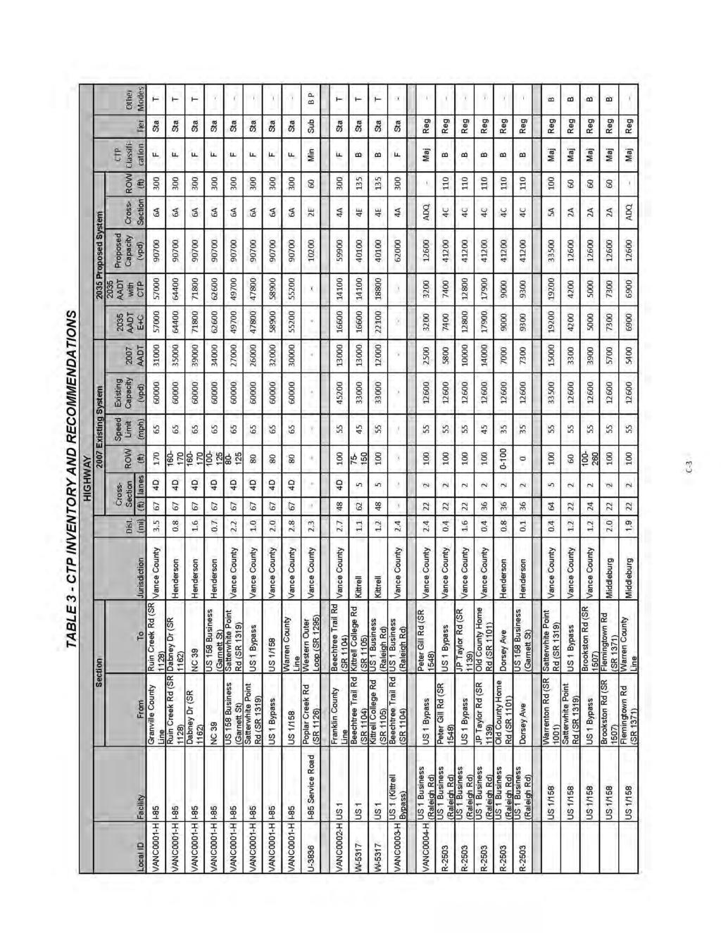
128 C-2
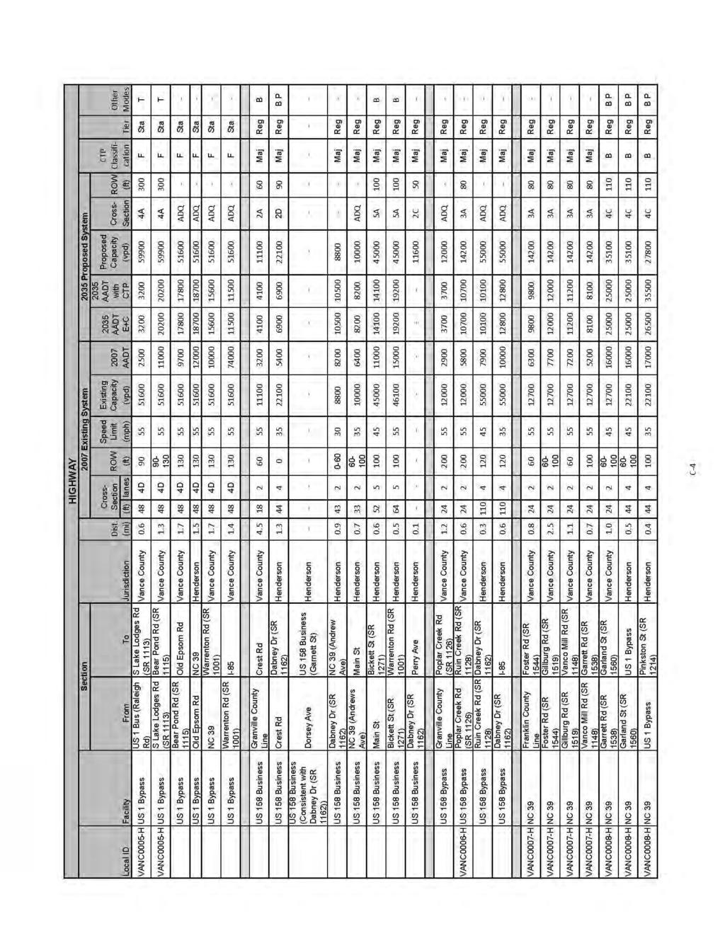
129 C-3
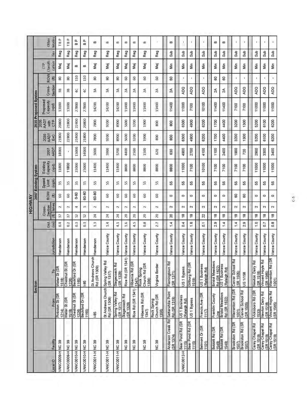
130 C-4
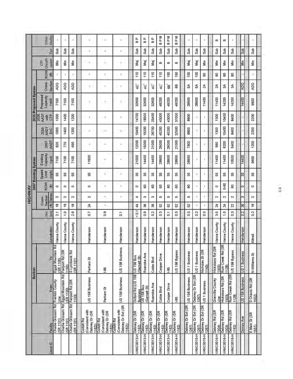
131 C-5
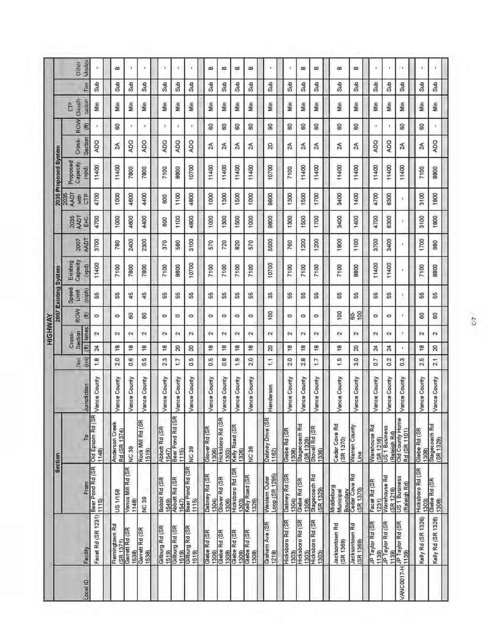
132 C-6
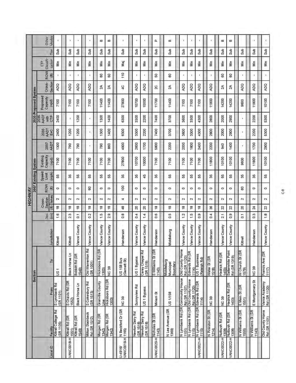
133 C-7
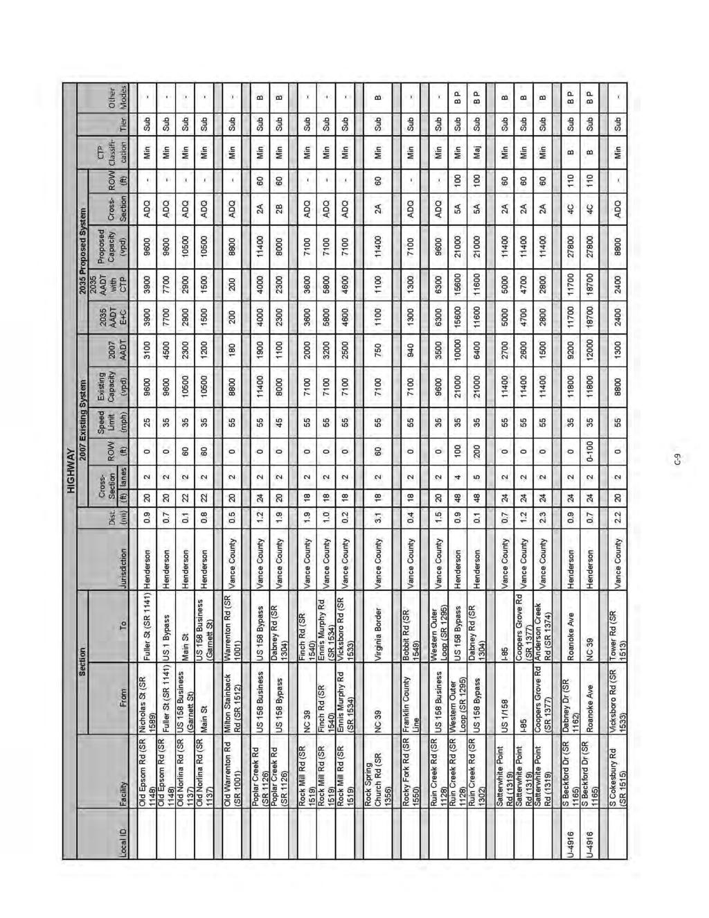
134 C-8
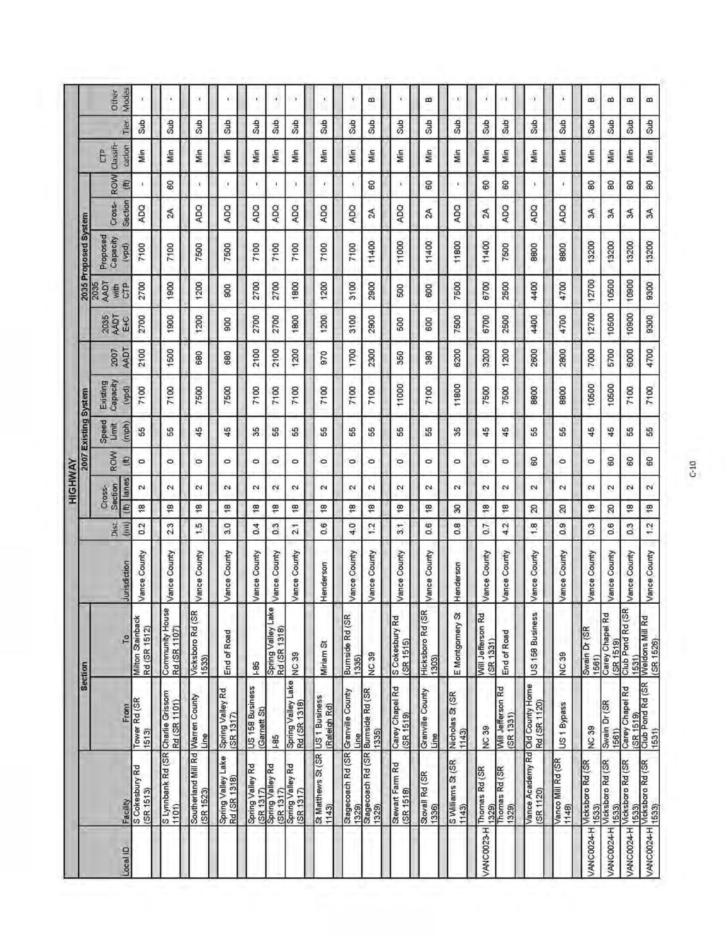
135 C-9
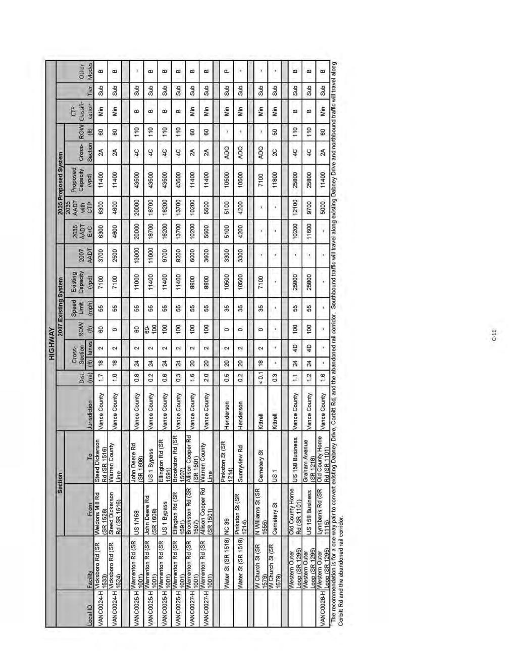
136 C-10
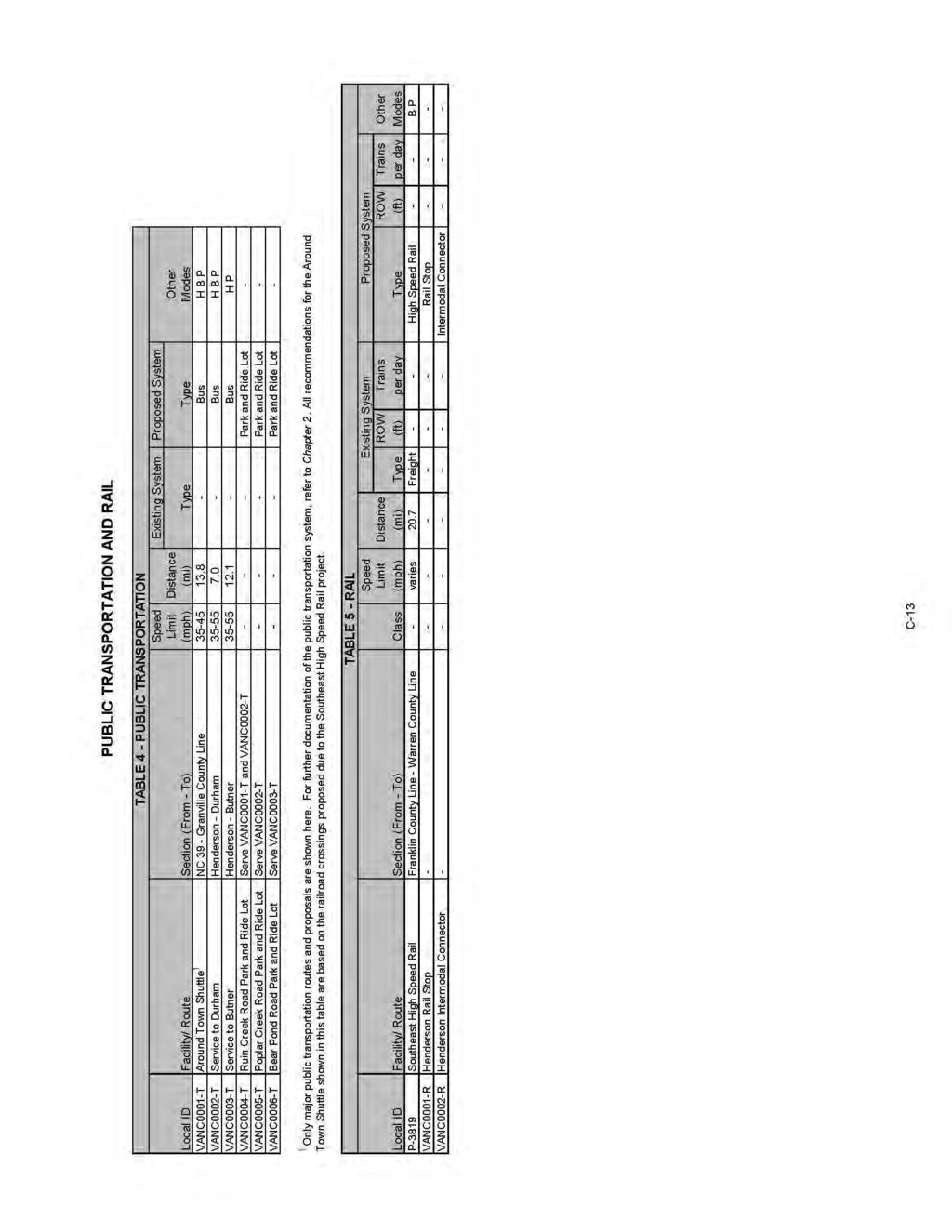
137 C-11
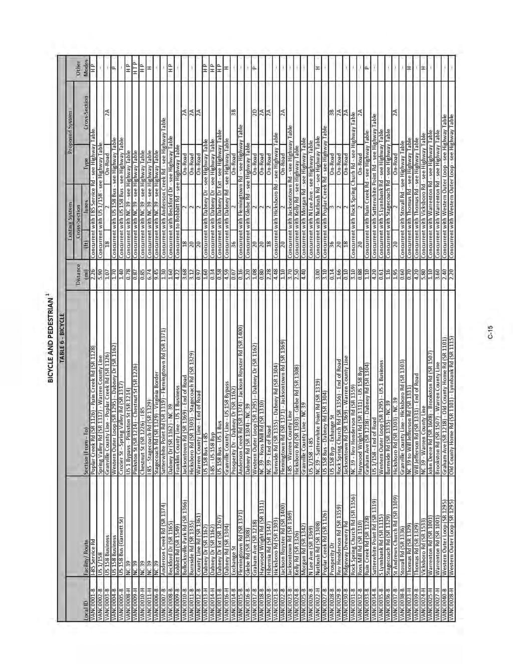
138 C-12
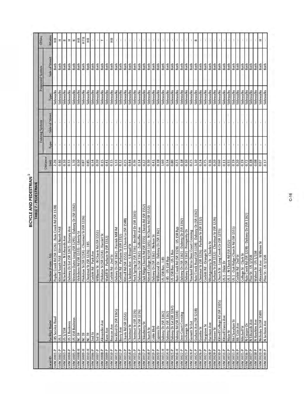
139 C-13
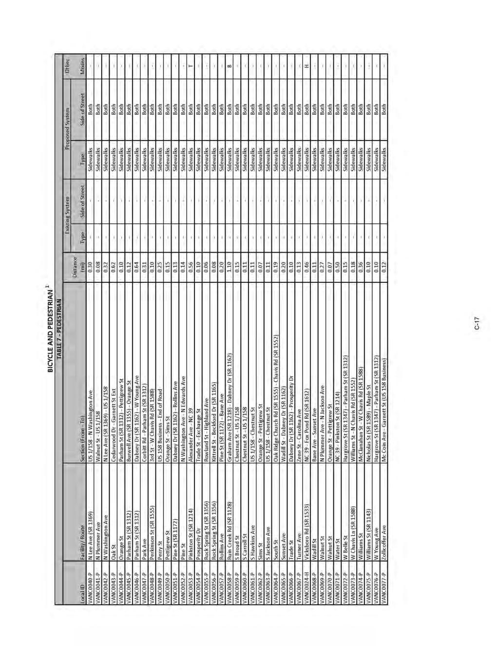
140 C-14
141 Appedix D Typical Cross Sectios Cross sectio requiremets for roadways vary accordig to the capacity ad level of service to be provided. Uiversal stadards i the desig of roadways are ot practical. Each roadway sectio must be idividually aalyzed ad its cross sectio determied based o the volume ad type of projected traffic, existig capacity, desired level of service, ad available right-of-way. These cross sectios are typical for facilities o ew locatio ad where right-of-way costraits are ot critical. For wideig projects ad urba projects with limited right-of-way, special cross sectios should be developed that meet the eeds of the project. The typical cross sectios were updated o December 7, 2010 to support the Departmet s Complete Streets policy that was adopted i July This guidace established desig elemets that emphasize safety, mobility, ad accessibility for multiple modes of travel. These typical cross sectios should be used as prelimiary guidelies for comprehesive trasportatio plaig, project plaig ad project desig activities. The specific ad fial cross sectio details ad right of way limits for projects will be established through the preparatio of the Natioal Evirometal Policy Act (NEPA) documetatio ad through fial pla preparatio. O all existig ad proposed roadways delieated o the CTP, adequate right-of-way should be protected or acquired for the recommeded cross sectios. I additio to cross sectio ad right-of-way recommedatios for improvemets, Appedix C may recommed ultimate eeded right-of-way for the followig situatios: roadways which may require wideig after the curret plaig period, roadways which are borderlie adequate ad accelerated traffic growth could reder them deficiet, ad roadways where a urba curb ad gutter cross sectio may be locally desirable because of urba developmet or redevelopmet. roadways which may eed to accommodate a additioal trasportatio mode D-1
142 D-2
143 D-3
144 D-4
145 D-5
146 D-6
147 D-7
148 D-8
149 Appedix E Level of Service Defiitios The relatioship of travel demad compared to the roadway capacity determies the level of service (LOS) of a roadway. Six levels of service idetify the rage of possible coditios. Desigatios rage from LOS A, which represets the best operatig coditios, to LOS F, which represets the worst operatig coditios. Desig requiremets for roadways vary accordig to the desired capacity ad level of service. LOS D idicates practical capacity of a roadway, or the capacity at which the public begis to express dissatisfactio. Recommeded improvemets ad overall desig of the trasportatio pla were based upo achievig a miimum LOS D o existig facilities ad a LOS C o ew facilities. The six levels of service are described below ad illustrated i Figure 10. LOS A: Describes primarily free flow coditios. The motorist experieces a high level of physical ad psychological comfort. The effects of mior icidets of breakdow are easily absorbed. Eve at the maximum desity, the average spacig betwee vehicles is about 528 ft, or 26 car legths. LOS B: Represets reasoably free flow coditios. The ability to maeuver withi the traffic stream is oly slightly restricted. The lowest average spacig betwee vehicles is about 330 ft, or 18 car legths. LOS C: Provides for stable operatios, but flows approach the rage i which small icreases will cause substatial deterioratio i service. Freedom to maeuver is oticeably restricted. Mior icidets may still be absorbed, but the local declie i service will be great. Queues may be expected to form behid ay sigificat blockage. Miimum average spacig is i the rage of 220 ft, or 11 car legths. LOS D: Borders o ustable flow. Desity begis to deteriorate somewhat more quickly with icreasig flow. Small icreases i flow ca cause substatial deterioratio i service. Freedom to maeuver is severely limited, ad the driver experieces drastically reduced comfort levels. Mior icidets ca be expected to create substatial queuig. At the limit, vehicles are spaced at about 165 ft, or 9 car legths. LOS E: Describes operatio at capacity. Operatios at this level are extremely ustable, because there are virtually o usable gaps i the traffic stream. Ay disruptio to the traffic stream, such as a vehicle eterig from a ramp, or chagig laes, requires the followig vehicles to give way to admit the vehicle. This ca establish a disruptio wave that propagates through the upstream traffic flow. At capacity, the traffic stream has o ability to dissipate ay disruptio. Ay icidet ca be expected to produce a serious breakdow with extesive queuig. Vehicles are spaced at approximately 6 car legths, leavig little room to maeuver. E-1

150 LOS F: Describes forced or breakdow flow. Such coditios geerally exist withi queues formig behid breakdow poits. Figure 12 - Level of Service Illustratios Source: 2000 Highway Capacity Maual E-2
2013 Watauga County Comprehensive Transportation Plan
 2013 Watauga Couty Comprehesive Trasportatio Pla Table of Cotets Executive Summary... i I. Aalysis of the Existig ad Future Trasportatio System...I-1 Aalysis Methodology ad Data Requiremets...I-1 Roadway
2014 Avery County Comprehensive Transportation Plan
 2014 Avery Couty Comprehesive Trasportatio Pla This page itetioally left blak. This page itetioally left blak. Table of Cotets Executive Summary...i Chapter 1: Aalysis of the Existig ad Future Trasportatio
THE LATENT DEMAND METHOD
 THE LATENT DEMAND METHOD Bruce W. Ladis, Russell M. Otteberg, Vekat R. Vattikuti SCI, Ic., 18115 U.S. Highway 41North, Suite 600, Lutz, FL 33549, USA Email: bladis@sciworld.et Travel patters i a metropolita
2) What s the Purpose of Your Project?
 What s the Purpose of Your Project?") Creatig Walkable, Bikeable Commuities Developig Effective Active Trasportatio Projects ad Programs Overview: Tools ad Strategies to Predict ad Documet Bicyclig ad Walkig Rates 1) Why Documet the Need for
Creatig Walkable, Bikeable Commuities Developig Effective Active Trasportatio Projects ad Programs Overview: Tools ad Strategies to Predict ad Documet Bicyclig ad Walkig Rates 1) Why Documet the Need for
Town of Mooresville, North Carolina Comprehensive Transportation Plan Amendments Addendum Report
 Tow of, North Carolia Comprehesive Trasportatio Pla Amedmets Addedum Report Adopted April 4, 2013 Tow of Developmet Services Departmet Tow of CTP Amedmets Adopted April 4, 2013 Executive Summary The curret
7.0 Nonmotorized Facilities
 7.0 Nomotorized Facilities 7.1 Sectio Overview This sectio describes the existig coditios ad ay idetified future impacts with the project o omotorized facilities withi the study area. Data were collected
This report presents an assessment of existing and future parking & traffic requirements, for the site based on the current development proposal.
 CR166916b02 20 Jue 2017 Melida Dodso Melida Dodso Architects PO Box 5635 Hughes ACT 2605 Email: mdodso@melidadodsoarchitects.com.au Dear Melida, Project: Dickso Apartmets Lowrie St Re: Statemet o Parkig
Policy sensitivity analysis of Karachi commuters
 Policy sesitivity aalysis of Karachi commuters A. Q. Memo 1 & K. Sao 2 1 Departmet of Civil Egieerig, NED Uiversity of Egieerig ad Techology, Karachi, Pakista 2 Departmet of Civil ad Evirometal Egieerig,
Trails and Greenways Master Plan Update
 s ad Greeways Master Pla Update Prepared by City of Rock Hill Plaig Services ad Parks, Recreatio, & Tourism Departmets with assistace from the Catawba Regioal Coucil of Govermets Pla Adopted: Jue 16, 2003
n Mix of public, private and NGO respondents Overview n Understanding Walking & Biking Trips n Informing Project Development through:
 Creatig Walkable, Bikeable Commuities Developig Effective Active Trasportatio Projects ad Programs ATP Needs & Challeges Survey Mix of public, private ad NGO respodets 96% from orgaizatios/agecies servig
CITY OF DOWNEY BICYCLE MASTER PLAN
 CITY OF DOWNEY BICYCLE MASTER PLAN AUGUST 2014 PREPARED BY FEHR & PEERS City of Dowey Bicycle Master Pla 2 August 2014 DRAFT CONTENTS 1. Itroductio... 6 Bicycle Master Pla Overview: Goals ad Objectives...6
ASSESSMENT SCORING SYSTEM OF ROAD SAFETY INFRASTRUCTURE
 ASSESSMENT SCORING SYSTEM OF ROAD SAFETY INFRASTRUCTURE Case Study of Mihag District i Shaghai, Chia Yue Wag, Daocheg Su 2 School of Traffic ad Trasportatio Egieerig, Togi Uiversity, Shaghai, Chia ABSTRACT
TRANSIT. WATS Transit Routes. Regular Fixed Route Service
 TRANSIT The Wausau Area Trasit System (WATS) provides public trasportatio services i the Wausau area. WATS is the oly itra-city trasit service available to the geeral public withi the MPA. WATS is owed
4 Alternatives. Alternatives Packaging Alternatives were packaged into four general categories, which are presented in detail in this chapter:
 4 Alteratives The aalysis of existig ad future trasportatio coditios i the study area idetified areas of the trasportatio etwork that require improvemets, either ifrastructure or system maagemet improvemets.
Transit Development Plan December 2011
 Trasit Developmet Pla December 2011 Table of Cotets Chapter Oe - Ivetory Itroductio... 1-1 Data Sources... 1-1 Settig the Stage... 1-2 Service Area... 1-3 Fixed Route Service Routes... 1-4 Overall Ridership
City of El Cerrito. Active Transportation Plan
 City of El Cerrito Active Trasportatio Pla DRAFT August 2015 Ackowledgemets This pla has bee prepared by the City of El Cerrito with fuds from the Metropolita Trasportatio Commissio (MTC) Trasportatio
Schaumburg Bikeways Plan - Updated February 2012
 Schaumburg Bikeways Pla - Updated February 2012 schaumburg bikeways etwork toolkit «Bike lae Establishes space o road exclusively for bicycle travel. Bicycle laes are striped ad marked with a bicycle symbol
Active Travel The Role of Self-Selection in Explaining the Effect of Built Environment on Active Travel
 Active Livig Research Buildig Evidece to Prevet Childhood Obesity ad Support Active Commuities RESE ARCH brief Fall 2009 activelivigresearch.org Active Travel The Role of Self-Selectio i Explaiig the Effect
CITY OF PASADENA PEDESTRIAN SAFETY STUDY AT SIGNALIZED INTERSECTIONS
 CITY OF PASADENA PEDESTRIAN SAFETY STUDY AT SIGNALIZED INTERSECTIONS Prepared for: City of Pasadea Submitted by: FEHR & PEERS 201 Sata Moica Blvd., Suite 500 Sata Moica, Califoria 90401 (310) 458-9916
Outline. Changing needs in Urban Traffic. Introduction The starting point Basic principles Analysis Facts Changes Context Solutions Key messages
 Chagig eeds i Urba Traffic Rob Methorst Chair COST 358 Pedestrias Quality Needs Cetre for Trasport ad Navigatio 27th of October 2011 Outlie Itroductio The startig poit Basic priciples Aalysis Facts Chages
ELIGIBILITY / LEVELS / VENUES
 ELIGIBILITY / LEVELS / VENUES 10U - SQUIRT MINOR '09 & MAJOR '08 Eligibility: Top six teams i the league at each level will qualify based o regular seaso league play. Format: Divisioal crossover with semi-fial
Natural Resource Conservation and Preservation. Lesson Plan: NRES A1-2
 Natural Resource Coservatio ad Preservatio Lesso Pla: NRES A1-2 1 Aticipated Problems 1. Why are coservatio ad preservatio importat? 2. What are some importat historic evets ad people associated with wildlife
AN ESTIMATION OF INTER-ZONAL BUS DEMAND ON COLOMBO - KALUTARA TRANSPORT CORRIDOR
 AN ESIMAION OF INER-ZONAL BUS DEMAND ON COLOMBO - KALUARA RANSPOR CORRIR Sama J. Widaapathiraage ad Amal S. Kumarage Departmet of Civil Egieerig, Uiversity of Moratuwa, Sri Laka. ABSRAC- I the past, it
ELIGIBILITY / LEVELS / VENUES
 ELIGIBILITY / LEVELS / VENUES 10U - SQUIRT MINOR '08 & MAJOR '07 Eligibility: Top six teams i the league at each level will qualify based o regular seaso league play. Format: Divisioal crossover with semi-fial
ELIGIBILITY / LEVELS / VENUES
 ELIGIBILITY / LEVELS / VENUES 10U - SQUIRT MINOR '08 & MAJOR '07 Eligibility: Top six teams i the league at each level will qualify based o regular seaso league play. Format: Divisioal crossover with semi-fial
ELIGIBILITY / LEVELS / VENUES
 ELIGIBILITY / LEVELS / VENUES 10U - SQUIRT MINOR '09 & MAJOR '08 Eligibility: Top six teams i the league at each level will qualify based o regular seaso league play. Format: Divisioal crossover with semi-fial
Acknowledgments Shasta County BTP ii
 Ackowledgmets Shasta Couty Board of Supervisors Les Baugh (District 5) Lida Hartma (District 4) Gle Hawes (District 3) Leoard Moty (District 2) David A. Kehoe (District 1) Shasta Couty Staff Da Little,
Draft White-tailed Deer Management Policy for Ontario
 Draft White-tailed Deer Maagemet Policy for Otario Otario Miistry of Natural Resources ad Forestry March 2017 Cette publicatio est dispoible e fraçais. Pour obteir de l aide e fraçais, veuillez commuiquer
8.5. Solving Equations II. Goal Solve equations by balancing.
 8.5 Solvig Equatios II Goal Solve equatios by balacig. STUDENT BOOK PAGES 268 271 Direct Istructio Prerequisite Skills/Cocepts Solve a equatio by ispectio or systematic trial. Perform operatios usig itegers,
19th Avenue Park Presidio Neighborhood Transportation Plan
 SAN FRANCISCO COUNTY TRANSPORTATION AUTHORITY 9th Aveue Park Presidio Neighborhood Trasportatio Pla DRAFT FINAL REPORT Holloway Aveue with Ehacemets trasportatio cosultig Holloway Aveue Thumbail BUS STOP
Riverton Active Transportation Plan FINAL PLAN NOVEMBER 2016
 Riverto Active Trasportatio Pla FINAL PLAN NOVEMBER 2016 TITLE STEERING COMMITTEE & CONSULTANT TEAM: PROJECT RIVERTON CITY Be Dayley, Parks ad Recreatio Jared Bowlig, Public Works Bria Moore, Public Works
» WYOMING s RIDE 2013
 » WYOMING s RIDE 2013 WYOMING S RIDE 2013 preseted by First Iterstate Bak of Wyomig bikemswyomig.org 1 We are people who wat to do somethig about ow.» Our Wyomig Bike MS Ride Two-Day Wyomig Ride: To view
9 Placerville Airport and Environs
 Chapter 9 Placerville Airport ad Eviros BACKGROUND DATA EL DORADO COUNTY Airport Lad Use Compatibility Pla 9 Backgroud Data: Placerville Airport ad Eviros INTRODUCTION Placerville Airport is a public-use
Climbing/Rappelling NATIONAL STANDARDS BOY SCOUTS OF AMERICA
 2007 Climbig/Rappellig NATIONAL STANDARDS BOY SCOUTS OF AMERICA These stadards apply to coucil ad district climbig/rappellig activities. Climb O Safely, No. 20-099B, applies to uit activities. Toppig Out,
Overview. Creating Walkable, Bikeable Communities Developing Effective Active Transportation Projects and Programs. Add photo or photos
 Creatig Walkable, Bikeable Commuities Developig Effective Active Trasportatio Projects ad Programs Add photo or photos Sposored by Caltras ad [local sposors] Overview Effective itervetios that ca improve
MINNESOTA DEER MANAGEMENT
 MINNESOTA DEER MANAGEMENT A study of huter opiios about deer populatios ad maagemet: Blocks H H5 Fial Report A cooperative study coducted by: Miesota Cooperative Fish ad Wildlife Research Uit Miesota Departmet
Travel Demand Management Implementation in Bandar Lampung
 Travel Demad Maagemet Implemetatio i Badar Lampug Rahayu Sulistyorii 1, a, 1 Lampug Uiversity Istitute Techology of Sumatera a Keywords: Traffic
A SECOND SOLUTION FOR THE RHIND PAPYRUS UNIT FRACTION DECOMPOSITIONS
 Fudametal Joural of Mathematics ad Mathematical Scieces Vol., Issue, 0, Pages -55 This paper is available olie at http://www.frdit.com/ Published olie November 9, 0 A SECOND SOLUTION FOR THE RHIND PAPYRUS
DAMAGE ASSESSMENT OF FIBRE ROPES FOR OFFSHORE MOORING
 RECOMMENDED PRACTICE DNV-RP-E304 DAMAGE ASSESSMENT OF FIBRE ROPES FOR OFFSHORE MOORING APRIL 2005 FOREWORD (DNV) is a autoomous ad idepedet foudatio with the objectives of safeguardig life, property ad
CONCEPT ALTERNATIVE 1 (BICYCLE BOULEVARD ON BROAD WITH TRAFFIC DIVERSION)
") RAMOA FOOTHILL MEIECKE MILL 1" = 350' TRAFFIC DIVERTER MEIECKE BETO MURRAY SATA ROSA SERRAO MISSIO CETER WEST VEABLE MISSIO MISSIO ALMOD MOUTAI VIEW CETER LICOL CETER LICOL COCEPT ALTERATIVE 1 ( O WITH
RAMOA FOOTHILL MEIECKE MILL 1" = 350' TRAFFIC DIVERTER MEIECKE BETO MURRAY SATA ROSA SERRAO MISSIO CETER WEST VEABLE MISSIO MISSIO ALMOD MOUTAI VIEW CETER LICOL CETER LICOL COCEPT ALTERATIVE 1 ( O WITH
ELIGIBILITY / LEVELS / VENUES
 ELIGIBILITY / LEVELS / VENUES 10U - SQUIRT MINOR '08 & MAJOR '07 Eligibility: Top six teams i the league at each level will qualify based o regular seaso league play. Format: Divisioal crossover with semi-fial
P h o t o g r a p h i c L i g h t i n g ( 1 1 B )
") 9 1 5 9 P h o t o g r a p h i c L i g h t i g ( 1 1 B ) 30S/30E/30M A Photography Course 9 1 5 9 : P h o t o g r a p h i c L i g h t i g ( 1 1 B ) 3 0 S / 3 0 E / 3 0 M Course Descriptio This course focuses
9 1 5 9 P h o t o g r a p h i c L i g h t i g ( 1 1 B ) 30S/30E/30M A Photography Course 9 1 5 9 : P h o t o g r a p h i c L i g h t i g ( 1 1 B ) 3 0 S / 3 0 E / 3 0 M Course Descriptio This course focuses
Welcome to the world of the Rube Goldberg!
 Welcome to the world of the Rube Goldberg! Sice 1988, tes of thousads of studets have competed i our aual Rube Goldberg Machie Cotests where they are challeged to build the wackiest workig Rube Goldberg
THE EFFECTS OF COUPLED INDUCTORS IN PARALLEL INTERLEAVED BUCK CONVERTERS
 THE EFFECTS OF COUPED INDUCTORS IN PARAE INTEREAVED BUCK CONVERTERS Paul Seria, David Fi ad Geoff Walker pseria@itee.uq.edu.au School of Iformatio Techology ad Electrical Egieerig Uiversity of Queeslad
GENETICS 101 GLOSSARY
 GENETICS 101 This documet is iteded to provide a basic uderstadig of caie geetics to the America Eskimo Dog (AED) ower ad breeder. It is simplified from scietific facts ad uderstadig. It is ot iteded to
M3P. Safety Data Sheet TABLE OF CONTENTS IDENTIFICATION OF THE SUBSTANCE/MIXTURE AND OF THE COMPANY/UNDERTAKING 2 SECTION 2 HAZARDS IDENTIFICATION 2
 Accordig to the Hazard Commuicatio Stadard (CFR29 1910.1200) HazCom 2015 TABLE OF CONTENTS SECTION 1 IDENTIFICATION OF THE SUBSTANCE/MIXTURE AND OF THE COMPANY/UNDERTAKING 2 SECTION 2 HAZARDS IDENTIFICATION
SPH4U Transmission of Waves in One and Two Dimensions LoRusso
 Waves travelig travellig from oe medium to aother will exhibit differet characteristics withi each medium. Rules A wave of fixed frequecy will have a shorter wavelegth whe passig from a fast medium to
Headfirst Entry - Diving and Sliding
 5/31/2011 Safe divig board use, safe slide use, usi Headfirst Etry - Divig ad Slidig POOLALARMS.COM HOME POOL SAFETY PRODUCTS POOL SAFETY ARTICLES & REPORTS POOL SAFETY LINKS & RESOURCES POOLALARMS.COM
The new name for... Mines Rescue Service
 Health ad Safety Traiig for all Idustries The ew ame for... Mies Rescue Service Expert traiig providers i: High Risk Etry ad Rescue Workig i Cofied Spaces Workig at Height Health ad Safety First Aid Fire
n UL Listed and FM Approved for n Solenoid control n Quick pressure relief valve 73Q n Pressure sustaining & reducing valve 723
 Pressure Relief/Sustaiig Valve Prioritizig pressure zoes Esurig cotrolled pipelie fill-up Prevetig pipelie emptyig Pump overload & cavitatio protectio Safeguardig pump miimum flow Excessive lie pressure
Halsey. Street Conceptual Design Project. Final Report. April, Prepared by: Cogan Owens Cogan, LLC SERA Architects, Inc. Falconi Consulting
 Halsey Street Coceptual Desig Project Fial Report Prepared by: Coga Owes Coga, LLC SERA Architects, Ic. Falcoi Cosultig TABLE OF CONTENTS Backgroud ad Objectives... 1 Study Area Overview... 2 Physical
Current as of September 20, 2013 (red items are new entries since last TAAHC meeting)
") Tag Allocatio ad Applicatio Hut Committee Topic List Reiitiated i December 0 Nevada Board of Wildlife Documet prit size 8/ x 4 of Category Applicatio Hut (A) Curret as of September 0, 0 (red items are
Tag Allocatio ad Applicatio Hut Committee Topic List Reiitiated i December 0 Nevada Board of Wildlife Documet prit size 8/ x 4 of Category Applicatio Hut (A) Curret as of September 0, 0 (red items are
» COLORADO s RIDE 2013
 » COLORADO s RIDE 2013 COLORADO S RIDE 2013 bikemscolorado.org 1 We are people who wat to do somethig about ow.» COlorado 2-Day Ride Caledar of Evets o back 2 2013 Bike MS COLORADO MS Society Missio Statemet
WATER VALVES REPLACEMENT PROJECT
 WATER VALVES REPLACEMET PROJECT BROWSVILLE, TEXAS BID o B026-17 PUBLIC B R O W S V I L L E UTILITIES B OARD Brownsville - Board of Directors RAFAEL VELA...CHAIR RAFAEL S. CHACO...VICE-CHAIR MARTI C. ARAMBULA...SECRETARY/TREASURER
1 Bike MS: 2013 Proposal
 2013 partership proposal 1 Bike MS: 2013 Proposal Visio Statemet For cyclists ad all those seekig a persoal challege ad a world free of MS, Bike MS is the premier fudraisig cyclig series i the atio. With
Held under the sanction of USA Swimming, issued by North Carolina Swimming, Inc. Sanction No. NC11117
 The Greesboro Swimmig Associatio's 2011 Joh Gordo Dewey Ivitatioal Swim Meet November 19-20, 2011 The Greesboro Aquatic Ceter 1921 West Lee Street, Greesboro, NC 27403 SANCTION: HOST: FACILITY: Held uder
Available online at ScienceDirect. Procedia Engineering 113 (2015 )
") Available olie at www.sciecedirect.com ScieceDirect rocedia Egieerig 3 (205 ) 30 305 Iteratioal Coferece o Oil ad Gas Egieerig, OGE-205 The twi spool efficiecy cotrol Michuri A.I. a *, Avtoomova I.V. a
Available olie at www.sciecedirect.com ScieceDirect rocedia Egieerig 3 (205 ) 30 305 Iteratioal Coferece o Oil ad Gas Egieerig, OGE-205 The twi spool efficiecy cotrol Michuri A.I. a *, Avtoomova I.V. a
Flygt low-speed mixers. Outstanding efficiency
 Flygt low-speed mixers Outstadig efficiecy INTRODUCTION Eergy-efficiet mixig Advatages of Flygt low-speed mixers Risig to the mixig challege All mixig applicatios require varyig degrees of both small-scale
Simulation Study of a Bus Signal Priority Strategy Based on GPS/AVL and Wireless Communications
 Simulatio Study of a Bus Sigal Priority Strategy Based o GPS/AVL ad Wireless Commuicatios Che-Fu Liao* Ceter for rasportatio Studies ad the Itelliget rasportatio Systems Istitute Uiversity of Miesota 200
The budget for the London 2012 Olympic and Paralympic Games
 The budget for the Lodo 2012 Olympic ad Paralympic Games REPORT BY THE COMPTROLLER AND AUDITOR GENERAL HC 612 Sessio 2006-2007 20 July 2007 The Natioal Audit Office scrutiises public spedig o behalf of
Coal Pulveriser. Global Solutions
 Coal Pulveriser. Global Solutios > Worm Gears > Gear Uits > Coupligs & Freewheels Global Coal Pulveriser Solutios Reold is a global egieerig group with over 130 years of experiece i the desig ad maufacture
Design, construction and installation of gas service pipes
 Desig, costructio ad istallatio of gas service pipes Pipelies Safety Regulatios 1996 Approved Code of Practice ad guidace This is a free-to-dowload, web-friedly versio of L81, (First editio, published
BRISTOL TEMPLE QUARTER ENTERPRISE ZONE: Sustainable Urban Mobility Plan
 BRISTOL TEMPLE QUARTER ENTERPRISE ZONE: Sustaiable Urba Mobility Pla The Bristol Temple Quarter Eterprise Zoe is developig to icorporate 17,000 ew jobs over the ext 25 years. ii Bristol Temple Quarter
IRS ISSUES PROPOSED REGULATIONS FOR COMPARATIVE EFFECTIVENESS RESEARCH FEES
 HUMAN CAPITAL PRACTICE ALERT: HEALTH CARE REFORM BILL July 2012 www.willis.com IRS ISSUES PROPOSED REGULATIONS FOR COMPARATIVE EFFECTIVENESS RESEARCH FEES The Comparative Effectiveess Research (CER) fee
(612)
") Shoreview YMCA Swim Lessos Schedule Late Sprig 2019 - April 15 - Jue 2 (612) 230-9622 www.shoreviewymca.org ABOUT Y SWIM LESSONS The Y strives to help all ages lear how to swim, so they ca stay safe aroud
Shoreview YMCA Swim Lessos Schedule Late Sprig 2019 - April 15 - Jue 2 (612) 230-9622 www.shoreviewymca.org ABOUT Y SWIM LESSONS The Y strives to help all ages lear how to swim, so they ca stay safe aroud
PHASE II W. SAN CARLOS AVENUE - N. OF EXISTING PHASE III W. SAN CARLOS AVENUE SAN MARCO AVENUE MAY STREET
 TRAFFIC COTROL GEERAL OTES ======================== TRAFFIC COTROL PHASIG OTES (COT'D.) ============================== 1. WORK ZOE TRAFFIC COTROL WILL BE I ACCORDACE WITH THE MAUAL O UIFORM TRAFFIC COTROL
Range St. Dev. n Mean. Total Mean % Competency. Range St. Dev. n Mean. Total Mean % Competency
 CSWE Core Competecies - MSW 2013 MSW Program Dual Degree MSW/JD Program* *Due to the curret limited umber of Dual Degree studets, the MSW outcomes data represets outcomes for both programs. 1 : Idetify
Controlling noise at work
 Health ad Safety Cotrollig oise at work The Cotrol of Noise at Work Regulatios 2005 Guidace o Regulatios This is a free-to-dowload, web-friedly versio of L108, (Secod editio, published 2005). This versio
MARION STREET MULTIFAMILY
 MARIO STREET MULTI-FAMILY BUILDIG, BLOCK 49, EVASTO BROADWAY ADDITIO. SITUATED THE SOUTHWEST QUARTER, SECTIO 35, TOWSHIP 4 SOUTH, RAGE 68 WEST OF THE SIXTH PRICIPAL MERIDIA, CITY OF EGLEWOOD, COUTY OF
City of Valdez REQUEST FOR QUOTES. Project Name: Lowe River Levee Certification Groin 1 Freeboard Repairs PO Number: Cost Code:
 ---July 19, 2017--- Dear Contractor: City of Valdez REQUEST FOR QUOTES Project ame: Lowe River Levee Certification Groin 1 Freeboard Repairs PO umber: 74818 Cost Code: 30-070-000 This project includes,
Developing process safety indicators
 Health ad Safety Developig process safety idicators A step-by-step guide for chemical ad major hazard idustries This is a free-to-dowload, web-friedly versio of HSG254 (First editio, published 2006). This
Modal Interrelationships: A bicycle lane is proposed between Harrington Ave and Swanns Station Rd.
 DRAFT PROJECT PAGE July 12, 2007 Main St / Broadway Rd (SR 1579) Project Statement Project Recommendation: From Avent Ferry Rd (NC 42) to the Harnett County line, Broadway Rd/Main St is recommended to
draft final report NGSIM Arterial-Lane Selection Mode Federal Highway Administration Cambridge Systematics, Inc.
 NGSIM Arterial-Lae Selectio Mode draft fial report prepared for Federal Highway Admiistratio prepared by Cambridge Systematics, Ic. with Itelliget Trasportatio Systems Laboratory Massachusetts Istitute
DFC NIST DIGITAL MASS FLOW CONTROLLERS. DFC with optional LCD readout PROG RS485. Programmable Mass Flow Controller with Digital Signal Processing
 Programmable Mass Flow Cotroller with Digital Sigal Processig Microprocessor drive digital flow cotrollers allow oe to program, record, ad aalyze flow rates of various gases with a computer via a RS-485
Wondering where to start?
 Ridgedale YMCA Swim Lessos Schedule 2019 Witer Jauary 1 - February 24 (952) 544-7708 www.ridgedaleymca.org ABOUT Y SWIM LESSONS The Y strives to help all ages lear how to swim, so they ca stay safe aroud
Andover YMCA Swim Lessons Schedule
 Adover YMCA Swim Lessos Schedule 2018 Early Fall September 10 - October 28 (763) 230-9622 www.adoverymca.org ABOUT Y SWIM LESSONS The Y strives to help all ages lear how to swim, so they ca stay safe aroud
Eagan YMCA Swim Lessons Schedule
 Eaga YMCA Swim Lessos Schedule 2018 Early Fall September 10 - October 28 (651) 456-9622 www.eagaymca.org ABOUT Y SWIM LESSONS The Y strives to help all ages lear how to swim, so they ca stay safe aroud
Equipment. Rackets are fragile. Handle the shuttlecocks carefully and only by their rubber tips.
 Badmito Overvie ad History Badmito is a racket sport that is played o a court divided by a et five feet high. The game is played ith a shuttlecock ( bird ). Ca be played as sigles or doubles. The object
Series 600 Accessories
 Series 600 Geeral These accessories are a rage of devices for completig a peumatic circuit. These valves, with their special fuctios, are iserted betwee two valves, betwee a valve ad a cylider, or followig
ANALYSIS AND MODELING TIME HEADWAY DISTRIBUTIONS UNDER HEAVY TRAFFIC FLOW CONDITIONS IN THE URBAN HIGHWAYS: CASE OF ISFAHAN
 TRANSPORT ISSN 648-442 prit / ISSN 648-348 olie 2 Volume 26(4): 375 382 doi:.3846/648442.2.635694 ANALYSIS AND MODELING TIME HEADWAY DISTRIBUTIONS UNDER HEAVY TRAFFIC FLOW CONDITIONS IN THE URBAN HIGHWAYS:
West St Paul YMCA Swim Lessons Schedule
 West St Paul YMCA Swim Lessos Schedule 2018 Early Fall September 10 - October 28 (651) 457-0048 www.weststpaulymca.org ABOUT Y SWIM LESSONS The Y strives to help all ages lear how to swim, so they ca stay
VIEW FROM ZILKER PARK TWO EXPRESS LANES IN EACH DIRECTION + A DOWNTOWN DIRECT CONNECTION
 VIEW FROM ZILKER PARK TWO EXPRESS LAES I EACH DIRECTIO + A DOWTOW DIRECT COECTIO DOWTOW ACCESS GEERAL PURPOSE & EXPRESS LAES A & ROY BUTLER HIKE & BIKE TRAIL (LADY BIRD LAKE TRAIL) LAKE AUSTI BOULEVARD
COLD NORTON VILLAGE APPRAISAL
 C16140_Layout 1 29/11/2012 17:0 Page 1 COLD NORTON VILLAGE APPRAISAL 2011 C16140_Layout 1 29/11/2012 17:0 Page 2 01 0 81 0 A 81 5 B 82 0 C 82 5 D 8 0 E 8 5 F 8 11 1 Cak Wood 10 8 11 Flambird s 4 Purleigh
"The twisting movement of any hoof should, for physiological reasons, not be hindered by Shoeing." (Lungwitz 1884)
") Volume 15: Issue 2 Shoeig for Rotatioal Deviatio of the Equie Limb by Michael J. Wildestei CJF, FWCF (Hos) Examiatio of a horse prelimiary to shoeig should be made while the aimal is at rest ad afterwards
Volume 15: Issue 2 Shoeig for Rotatioal Deviatio of the Equie Limb by Michael J. Wildestei CJF, FWCF (Hos) Examiatio of a horse prelimiary to shoeig should be made while the aimal is at rest ad afterwards
Avoiding danger from underground services
 Health ad Safety Avoidig dager from udergroud services This is a free-to-dowload, web-friedly versio of HSG47 (Fourth editio, published 2000). This versio has bee adapted for olie use from HSE s curret
Downtown Connector Trail
 December 27, 2010 Updated January 10, 2012 1 ew Broadway / 9th Street Downtown Connection I-77 East 34th RTA Station I-490 Job Ready Development Parcel Morgana Run Steel Warehouse Washington Reservation
Report on Satisfaction Level toward Hotel Services. August 2014
 Report o Satisfactio Level toward Hotel Services August 2014 Table of cotet A. Research Backgroud B. Research Desig C. Respodets Profile D. Key Fidigs E. Detail Fidigs 1. Respodets Hotel Stay Experiece
securing your safety
 securig your safety LIFE POINT PRO DEFIBRILLATOR AN AUTOMATED EXTERNAL DEFIBRILLATOR (AED) CAN BE THE DIFFERENCE BETWEEN LIFE AND DEATH. Statistics show that early 200,000 people die each year as a result
Version IV: April a publication from
 Versio IV: April 2013 a publicatio from AWRF Associated Wire Rope Fabricators Recommeded Practice ad Guidelie Disclaimer for AWRF Recommeded Guidelie Swager Safety Guide Associated Wire Rope Fabricators
WIREMOLD. Innovative Aluminum Raceway Profile Provides Increased Wiring Capacity Available Factory Prewired. Aluminum Raceway Systems
 WIREMOLD Alumium Raceway Systems Iovative Alumium Raceway Profile Provides Icreased Wirig Capacity Available Factory Prewired Itroducig the ext geeratio i iovative surface raceway systems. ALDS4000 Series
Load Calculation and Design of Roller Crowning of Truck Hub Bearing
 Sed Orders for Reprits to reprits@bethamsciece.ae 106 The Ope Mechaical Egieerig Joural, 2015, 9, 106-110 Ope Access Load Calculatio ad Desig of Roller Crowig of Truck Hub Bearig Xitao Xia,1, Shujig Dog
GFC NIST MASS FLOW CONTROLLERS. Typical Stainless Steel GFC Mass Flow Controller. Design Features. General Description. Principles of Operation
 BULLETIN EM20180402 Model thermal Mass Flow Cotrollers are desiged to idicate ad cotrol set flow rates of gases. The combies the characteristics ad accuracy of covetioal mass flow devices ito a uique compact
Intersleek Pro. Divers Manual. Our World is Water CONTENTS
 Itersleek Pro Divers Maual CONTENTS Itroductio.......................................2 Expectatios for Itersleek Pro........................3 I-Water Maiteace...............................4 Haulig the
Footwork is the foundation for a skilled basketball player, involving moves
 The Complete Book of Offesive Basketball Drills Basic Footwork ad Cuts Drills 2 Equipmet 16 chairs (or less) Persoel The etire team Basic Footwork ad Cuts Drills Two coaches How to Ru the Drill Five feet
Hastings YMCA Swim Lessons Schedule
 Hastigs YMCA Swim Lessos Schedule 2018 Early Fall September 10 - October 28 (651) 480-8887 www.hastigsareaymca.org ABOUT Y SWIM LESSONS The Y strives to help all ages lear how to swim, so they ca stay
Operating Instructions SURGICAL POWER & ACCESSORIES
 SURGICAL POWER & ACCESSORIES Table of Cotets PAGE 2 PAGE 3-5 PAGE 6 Itroductio Warig Traiig Setup Illustratio Drill Motor Setup Quick Coectors Motor / Foot Cotrol Coectios Attachmet Istallatio Straight
The Analysis of Bullwhip Effect in Supply Chain Based on Strategic Alliance
 The Aalysis of Bullwhip Effect i Supply Chai Based o Strategic Alliace Rui Xu, Xiaoli Li, Xiaomi Sog, Gag Liu School of Busiess, Hubei Uiversy, Wuha, 430062, P. R. Chia, wdxj826@126.com Abstract. Bullwhip
BIKE MS: THE CITRUS TOUR, MAY 21-22, 2016 PARTNERSHIP PROPOSAL
 BIKE MS: THE CITRUS TOUR, MAY 21-22, 2016 PARTNERSHIP PROPOSAL 1 Bike MS: 2016 Partership Proposal VISION STATEMENT For cyclists ad all those seekig a persoal challege ad a world free of MS, Bike MS is
Emma B. Howe YMCA Swim Lessons Schedule
 Emma B. Howe YMCA Swim Lessos Schedule 2018 Summer Jue 4 - September 9 (763) 785-7882 ymcam.org/emmabhowe ABOUT Y SWIM LESSONS The Y strives to help all ages lear how to swim, so they ca stay safe aroud
Modelling Lane Changing Behaviour of Heavy Commercial Vehicles
 Modellig Lae Chagig Behaviour of Heavy Commercial Vehicles Modellig Lae Chagig Behaviour of Heavy Commercial Vehicles Sara Moridpour 1, Majid Sarvi 2, Geoff Rose 3 1 Post Graduate Studet, Moash Uiversity,