THE GEORGE WASHINGTON UNIVERSITY SCIENCE AND ENGINEERING COMPLEX TRANSPORTATION IMPACT STUDY WASHINGTON, D.C.
|
|
|
- Erick Lucas
- 5 years ago
- Views:
Transcription
1 THE GEORGE WASHINGTON UNIVERSITY SCIENCE AND ENGINEERING COMPLEX TRANSPORTATION IMPACT STUDY WASHINGTON, D.C. Submitted on behalf of: The George Washington University Prepared by: Wells + Associates, Inc. November 2010
2 The George Washington University Science and Engineering Complex Transportation Impact Study Washington, D.C. TABLE OF CONTENTS PAGE Section 1 INTRODUCTION 1 OVERVIEW... 1 Site Location... 1 Proposed Redevelopment... 1 STUDY SCOPE... 2 Overview... 2 Study Area... 2 Study Objectives... 2 CONCLUSIONS AND RECOMMENDATIONS... 3 Section 2 BACKGROUND INFORMATION 5 EXISTING LAND USE... 5 PUBLIC ROADWAY NETWORK... 5 PUBLIC TRANSPORTATION FACILITIES AND SERVICES... 6 Metrorail... 6 Table 2-1: Foggy Bottom-GW Metrorail Station Passenger Boardings and Alightings... 6 Table 2-2: Foggy Bottom-GW Metrorail Station Passenger Access Modes... 6 Bus Service... 6 Table 2-3: Metorail Number of Bus Trips... 7 Table 2-4: Maryland Transit Administration Bus Service Number of Bus Trips... 8 GW CAMPUS TRANSPORTATION... 8 PEDESTRIAN ACCOMMODATIONS Pedestrian Accommodations at Signalized Intersections Pedestrian Accommodations at Unsignalized Intersections Pedestrian Master Plan BICYCLES ACCOMMODATIONS Bicycle Master Plan Table 2-5: Existing Bicycle Levels of Service Campus Bicycle Inventory Bike Sharing ZIPCAR PARKING Off-Street Parking Inventory On-Street Parking Inventory Table 2-6: Existing Off-Street Parking Inventory Table 2-7: On-Street Parking Inventory by Type of Parking Table 2-8: On-Street Parking Inventory by Time of Day Section 3 EXISTING CONDITIONS ANALYSIS 14 EXISTING TRANSPORTATION DEMAND MEASURES (TDM) Transportation Management Coordinator Public Transportation Pass GW Parking Facility Permits On-Campus Parking Pre-Tax Deduction Program Off-Campus Parking Pre-Tax Deduction Program Attendant/Valet Parking Carpool Programs Car Sharing ii
3 The George Washington University Science and Engineering Complex Transportation Impact Study Washington, D.C. TABLE OF CONTENTS (CONTINUED) PAGE Shuttle Bus Service Plan Technology Initiatives Web-based Transit Purchases Parking Management During On-Site Construction Truck Management Plan GW TRANSPORTATION CHARACTERISTICS Table 3-1: Summary of Respondents Foggy Bottom Campus Mode Choice Carpooling Characteristics Table 3-2: Mode Split Summary Foggy Bottom Campus TRAFFIC VOLUMES Existing Site Trips Table 3-3: Existing Site Trip Generation OPERATIONAL ANALYSIS Table 3-4: Existing Levels of Service Section 4 FUTURE BACKGROUND CONDITIONS 20 TRAFFIC VOLUMES Post Construction Conditions Regional Growth Pipeline Development PLANNED IMPROVEMENTS OPERATIONAL ANALYSIS Table 4-1: 2020 Background Levels of Service QUEUE ANALYSIS Table 4-2: 95 th Percentile Queue Summary Background Conditions Section 5 SITE ANALYSIS 25 OVERVIEW SITE ACCESS LOADING PROPOSED PARKING SUPPLY Off-Street Parking Inventory On-Street Parking Inventory BICYCLE REQUIREMENTS TRIP GENERATION ANALYSIS Overview Traffic Associated with the SEC Garage Table 5-1A: Vehicular Site Trip Generation Proposed SEC Garage Reassigned Traffic to Square 54 Garage Table 5-1B: Vehicular Site Trip Generation Square 54 Garage Reassigned Traffic to Square 103 (Law Learning Center) Garage Traffic Associated with Increase in Faculty/Staff SITE TRIP DISTRIBUTION AND ASSIGNMENT PROPOSED TDM MEASURES FOR THE SEC Car Sharing Parking for Electric Cars Bicycle Accommodations iii
4 The George Washington University Science and Engineering Complex Transportation Impact Study Washington, D.C. TABLE OF CONTENTS (CONTINUED) PAGE Truck Management Plan Section 6 TOTAL FUTURE CONDITIONS 29 TOTAL FUTURE TRAFFIC FORECASTS Proportional Impact Analysis Table 6-1: Proportional Impact Analysis OPERATIONAL ANALYSIS Table 6-2: Total Future Levels of Service QUEUE ANALYSIS Table 6-3: 95 th Percentile Queue Summary Total Future Conditions Section 7 IMPROVEMENT ANALYSIS 31 OVERVIEW QUEUE ANALYSIS Table 7-1: Total Future Levels of Service with Improvements Table 7-2: 95 th Percentile Queue Summary Total Future Conditions with Improvements Section 8 CONCLUSIONS AND RECOMMENDATIONS 33 REFERENCES 35 iv
5 The George Washington University Science and Engineering Complex Transportation Impact Study Washington, D.C. LIST OF FIGURES FIGURE TITLE 1-1 Site Location 1-2 Site Plan 1-3 Loading Area Plan 1-4 Pedestrian Entrance Locations 2-1 Existing Lane Use and Traffic Control 2-2 Functional Classification Map 2-3 Public Transportation Services 2-4A Existing Vern Express Route Monday Through Friday (All Times Except 6 AM to 10 AM) 2-4B Existing Vern Express Route Monday Through Friday (6 AM to 10 AM) 2-5 Proposed Vern Express Route Monday Through Friday (All Times Except 6 AM to 10 AM) 2-6 Existing Colonial Express Routes 2-7 Pedestrian Crossings at the 23 rd Street/H Street Intersection 2-8 Pedestrian Crossings at the 23 rd Street/I Street Intersection 2-9 Pedestrian Crossings at the 22 nd Street/H Street Intersection 2-10 Pedestrian Crossings at the 22 nd Street/I Street Intersection 2-11 Pedestrian Activity 2-12 Bicycle Levels of Service 2-13 Capital Bikeshare Locations 2-14 Zipcar Locations 2-15 Existing On-street Parking Restrictions 3-1 Existing Peak Hour Vehicular Traffic Volumes 3-2 Existing Peak Hour Pedestrian Volumes 4-1 Post Construction Peak Hour Vehicular Traffic Volumes 4-2 Peak Hour Pedestrian Volumes Adjusted for Post Construction Conditions 4-3 Post Construction Peak Hour Vehicular Traffic Volumes plus Regional Growth (2020) 4-4 Pipeline Development Traffic Assignments Future Background Peak Hour Traffic Forecasts Background Lane Use and Traffic Control 5-1 Existing versus Proposed Curb Parking Inventory 5-2 Proposed Bicycle Parking 5-3A Removal of Existing UPG Site Trips 5-3B Site Trip Assignment SEC Garage 5-3C Site Trip Assignment Square 54 Garage 5-3D Site Trip Assignment Square 103 Garage 5-3E Site Trip Assignment Increase in Faculty and Staff 5-3F Combined Site Trip Assignment All Components 5-4 Preferred Truck Routes Total Future Peak Hour Traffic Forecasts Total Future Lane Use and Traffic Control v
6 The George Washington University Science and Engineering Complex Transportation Impact Study Washington, D.C. LIST OF APPENDICES APPENDIX A B C D E F G H I J K L TITLE Traffic Count Data DDOT Traffic Signal Timings Level of Service Descriptions Existing Capacity Analyses Pipeline Developments 2020 Background Capacity Analyses 2020 Background Queue Analyses Truck Diagrams 2020 Total Future Capacity Analyses 2020 Total Future Queue Analysis 2020 Total Future Capacity Analyses with Improvements 2020 Total Future Queue Analyses with Improvements vi
7 The George Washington University Science and Engineering Complex Transportation Impact Study Washington, D.C. Section 1 INTRODUCTION OVERVIEW This report presents a Transportation Impact Study (TIS) of the proposed redevelopment of Square 55 on the Foggy Bottom Campus of The George Washington University (GW or the University), in Washington, D.C. The study was conducted in support of a Second-Stage Planned Unit Development (PUD) application for the proposed redevelopment. Site Location Square 55 is located in Ward 2 and is bounded by I Street on the north, H Street on the south, 22 nd Street on the east, and 23 rd Street on the west, as shown on Figure 1-1. Proposed Redevelopment On February 5, 2007, the Zoning Commission of the District of Columbia approved two applications by The George Washington University: (1) a special exception for a new Campus Plan and (2) first-stage approval of a PUD and related amendments to the Zoning Map of the District of Columbia. The order was adopted on March 12, 2007 and became final and effective on October 26, The approved Campus Plan identified Square 55 as one of the potential redevelopment sites on campus. The University is moving forward now with the Second-Stage PUD application for the Square 55 redevelopment. GW proposes to raze the existing 1,252-space (1,482-space with valet capacity) University Parking Garage (UPG), the existing 20-space Lot 2 surface parking lot, and the adjacent Physical Sciences Building (Building K) and construct a new Science and Engineering Complex (SEC) in its place, as shown on Figure 1-2. The existing Fulbright, Jacqueline Bouvier Kennedy Onassis (JBKO), and Munson Residence Halls will be retained. Construction is anticipated to begin in the spring of 2011 and be completed by the end of Occupancy of the new building is anticipated in January The new SEC will include 376,471 square feet (S.F.) of gross floor area (G.F.A.) on eight levels abovegrade. Two below-grade programmed levels plus 327 parking spaces (379 spaces including valet capacity) on four levels below-grade also are proposed. The departments that will occupy the SEC currently are located in 12 buildings throughout GW s Foggy Bottom Campus and leased space. The number of curb cuts around the perimeter of Square 55 will be reduced from seven to two. Five curb cuts (two on H Street, two on 22 nd Street, and one on I Street) that currently provide access to the UPG will be consolidated at a single, new curb cut on H Street, immediately west of the existing curb cuts, as shown on Figure 1-2. The new H Street curb cut will provide both access to and egress from the new 327-space (379-space including valet capacity) parking garage. A sixth curb cut on 23 rd Street that provides access to a single Zipcar space also will be closed. A single driveway on I Street will provide access to a new loading area within the existing service court defined by the Munson Residence Hall on the east, the JBKO Residence Hall on the west, and the new SEC on the south, as shown on Figure 1-3. The existing driveway will be widened. Pedestrian access to the SEC is proposed at the corner of 22 nd and H Streets, on 23 rd Street, and two locations on 22 nd Street. Pedestrian access to the retail component located at the northeast corner of the site will be provided via a door on I Street and internally through the SEC, as shown on Figure
8 The George Washington University Science and Engineering Complex Transportation Impact Study Washington, D.C. STUDY SCOPE Overview The University retained Wells + Associates to evaluate the multi-modal transportation impacts of redeveloping Square 55. The scope of the study and proposed methodologies were discussed with the District Department of Transportation (DDOT). Study Area The study area was selected based on those intersections that potentially could be affected by the proposed redevelopment. The following intersections were selected for detailed analysis: rd Street/I Street, nd Street/I Street, rd Street/H Street, nd Street/H Street, and 5. H Street/Proposed Driveway. Study Objectives The objectives of this study were to: 1. Evaluate existing traffic conditions, 2. Identify off-street parking impacts, 3. Identify on-street parking impacts on the blocks immediately surrounding Square 55, 4. Identify existing mode choices, 5. Project future traffic volumes without and with the proposed SEC, 6. Evaluate the effectiveness of the existing Transportation Management Plan and recommend changes, as necessary, 7. Analyze and recommend improvements to manage truck service and delivery activity, and 8. Recommend transportation improvements to promote the safe and efficient flow of vehicular and pedestrian traffic on campus. 2
9 The George Washington University Science and Engineering Complex Transportation Impact Study Washington, D.C. CONCLUSIONS AND RECOMMENDATIONS The conclusions and recommendations of this study are as follows: 1. Square 55 is well served by a high-quality multimodal transportation system that includes: a connected network of arterial, collector, and local streets; a connected network of sidewalks, paths, and open spaces; the adjacent Foggy Bottom-GWU Metrorail station; multiple regional bus lines; shuttle buses; and bicycle facilities. 2. The number of parking spaces on Square 55 will be reduced by 945 spaces (1,123 including valet capacity), from 1,272 parking spaces in the UPG and Lot 2 (1,502 including valet capacity) to 327 spaces (379 including valet capacity) in the SEC garage. 3. Parking will be more widely distributed throughout GW s Foggy Bottom Campus by redeveloping Squares 54, 55, and 103. Traffic will be more widely dispersed throughout the Campus rather than concentrated at relatively few large parking facilities (such as the UPG). 4. GW will maintain a minimum of 2,800 parking spaces through the year 2020 in compliance with the Campus Plan Order. 5. The number of curb cuts around the perimeter of Square 55 will be reduced from seven to two, which will reduce pedestrian/vehicle conflicts. 6. The number of curb parking spaces around the perimeter of Square 55 will be increased by an estimated eight spaces, from approximately 25 to approximately 33 spaces because of the reduced number of curb cuts and the relocation of the Vern Express bus stop from H Street to G Street. Six parking spaces will be displaced on G Street due to this bus stop relocation, resulting in a net gain of two curb parking spaces on the Campus. 7. The proposed modification of the I Street driveway will safely and adequately accommodate single-unit trucks and tractortrailer trucks up to 45 feet in length (WB-40) turning into and out of the driveway to and from the east and west on I Street. 8. One 55-foot tractor-trailer truck (WB-50) is expected to use the high-bay loading berth approximately once a quarter during off-peak times. The entire width of I Street will be required for these trucks to turn into and out of the I Street driveway, which will require temporary prohibition of curb parking on both sides of the street and manual street traffic control. These deliveries will be pre-scheduled all will occur on weekends. 9. An extensive truck management plan has been developed to accommodate the anticipated loading operations of the SEC and to minimize the impact of the building s truck operations. 10. The proposed development plan will provide approximately 80 bicycle parking spaces outside of the facility and 30 bicycle parking spaces in the SEC garage. The University currently is in the process of conducting a campus-wide inventory of bicycle parking. The University should continue to work with DDOT throughout the PUD process to ensure that adequate bicycle parking is provided. 11. The existing Vern Express shuttle bus stop will be relocated from the north side of H Street, east of 23 rd Street, to the north side of G Street, west of 22 nd Street in front of Funger Hall. 12. GW currently has an extensive Transportation Management Plan that promotes safe and efficient traffic operations within the Campus, encourages alternate modes of transportation, and maximizes the use of the on- and off-street parking facilities to efficiently serve the campus parking demands. The TMP also prohibits freshmen and sophomores from bringing vehicles to campus except in special circumstances. 3
10 The George Washington University Science and Engineering Complex Transportation Impact Study Washington, D.C. 13. As a result of GW s aggressive Transportation Management Plan, the GW community widely uses alternative modes of transportation. Specifically, 67 percent of faculty and staff at the Foggy Bottom Campus commute via a carpool or non-auto mode of transportation. Of the students who commute to campus, 79 percent do so via a carpool or non-auto mode of transportation. 14. In accordance with GW s TMP, the proposed SEC will encourage alternate modes of transportation by providing parking on-site for car sharing vehicles and electric cars, bicycle accommodations, and by providing shower and changing facilities on-site for those who choose to walk, bike, or jog to the facility. 15. Currently, the signalized intersections in the immediate vicinity of Square 55 operate at an overall acceptable LOS D or better during weekday AM and PM peak hours. Select lane groups operate near or at capacity at the 23 rd Street/I Street intersection. 16. Currently, side street movements from the Square 55 driveways on H and I Streets operate near or at capacity. 17. Under future conditions without the proposed redevelopment, the 23 rd Street/I Street intersection is projected to operate at overall capacity during the PM peak hour. The remaining signalized intersections in the study area will operate at acceptable overall levels of service. 18. The UPG currently generates 259 AM peak hour trips and 338 PM peak hour trips. The proposed SEC will generate 65 AM peak hour trips and 85 PM peak hour trips. Thus, the proposed SEC will generate 194 (or 75 percent) fewer AM peak hour trips and 253 (or 75 percent) fewer PM peak hour trips than the existing UPG. The remaining trips currently generated by the UPG will be dispersed to other locations, including Squares 54 and The proposed redevelopment will result in a reduction in trips at each of the off-site study intersections during the peak hours, with the exception of the 22 nd Street/I Street intersection. During the AM peak hour, traffic at this intersection is projected to increase by approximately five percent. 20. The volume of traffic entering and exiting the site via the H Street driveway is expected to decrease with the proposed redevelopment. 21. When installed, traffic signal timings at the 22 nd Street/I Street intersection should be based on future traffic projections in order to adequately accommodate traffic associated with the redevelopment of Square 55. GW and Boston Properties made the required contribution toward the signal in conjunction with the Square 54 development; it is not proposed in conjunction with the SEC development. 22. The proposed redevelopment will not have a significant impact on the traffic operations in the study area. 4
11 The George Washington University Science and Engineering Complex Transportation Impact Study Washington, D.C. Section 2 BACKGROUND INFORMATION EXISTING LAND USE The subject site was zoned C-3-C as part of the First-Stage PUD that applies to the Foggy Bottom Campus. The site currently is zoned C-3-C (Major Business and Employment Centers) and is occupied by the 1,482 space UPG, 20 space Lot 2, and GW s Physical Sciences Building. The C-3-C district is designed to accommodate major business and employment centers supplementary to the Central Business (C-4) District. The C-3-C District permits medium-high density development, including office, retail, housing, and mixed-use development. 1 The remainder of the Square is occupied by three residence halls, which will remain. The area surrounding the site is comprised of educational, retail, and residential uses. Redevelopment of Square 54, located one block to the north, is underway. This mixed-use development, consisting of office, residential, and retail uses, will be completed next year. The Foggy Bottom-GWU Metro Station is located at the northwest corner of the 23 rd Street/I Street intersection. PUBLIC ROADWAY NETWORK Square 55 is located within a connected network of arterial, collector, and local streets. Existing intersection lane use and traffic control at the study intersections are shown on Figure 2-1. The north-south streets through campus (21 st, 22 nd, and 23 rd Streets) and Pennsylvania Avenue/ Washington Circle primarily serve through commuter traffic. The east-west streets through campus (F, G, H, and I Streets) are more diverse and primarily serve local traffic. 23 rd Street is classified by DDOT as a principal arterial, as shown on Figure 2-2. Automobiles, public buses, private shuttle buses, pedestrians, bicyclists, and cars parked along the curb share this two-way, five-lane street. The Foggy Bottom-GWU Metrorail station, the University, the GW Hospital, the adjacent Golden Triangle/K Street business corridor, and local organizations such as the Red Cross and World Bank generate large numbers of pedestrians that use the sidewalks and crosswalks on 23 rd Street, particularly at I Street. Within the study area, three lanes operate in the northbound direction and two lanes operate in the southbound direction along 23 rd Street, however, due to construction on Square 54, the third northbound through lane currently is closed between I Street and Washington Circle. The average daily traffic (ADT) on 23 rd Street in the site vicinity is 18,500 vehicles per day (vpd). 2 The posted speed limit is 25 miles per hour (mph). The intersections of 23 rd Street with I and H Streets are controlled by traffic signals. 22 nd Street is a one-way collector, with two northbound travel lanes south of I Street. Typically, 22 nd Street carries three northbound travel lanes north of I Street; however, the western curb lane currently is closed due to the construction activities on Square 54. The posted speed limit is 35 mph. The 22 nd Street/I Street and 22 nd Street/H Street intersections are controlled by all-way stop signs. The ADT on 22 nd Street is 5,800 vpd within the study area. 3 I Street is a two-way, two-lane street in the vicinity of the site. Further east, between 21 st Street and Pennsylvania Avenue, I Street is one-way eastbound. The posted speed limit is 25 mph. The ADT is 3,700 vpd on the two-way portion in the vicinity of the site. 4 5
12 The George Washington University Science and Engineering Complex Transportation Impact Study Washington, D.C. Due to the construction taking place on Square 54, the I Street cartway currently is narrowed between 22 nd and 23 rd Streets. Currently, no on-street parking is permitted on this block as a result of the construction. The I Street/23 rd Street intersection is controlled by a traffic signal. The I Street/22 nd Street intersection is all-way stop controlled. I Street, between 23 rd and 24 th Streets, is a pedestrian mall, closed to vehicular traffic. H Street is a two-lane, east-west collector that provides one travel lane in each direction in the site vicinity. The intersection of H Street and 23 rd Street is controlled by a traffic signal. The H Street/22 nd Street intersection is controlled by stop signs on each approach. The ADT of the roadway varies from 3,400 to 3,800 vpd in the site vicinity. 5 PUBLIC TRANSPORTATION FACILITIES AND SERVICES GW is served by both Metrobus and Metrorail, as shown on Figure 2-3. Metrorail The Foggy Bottom-GWU Metrorail Station is located on the northwest quadrant of the 23 rd Street/I Street intersection. This is the eighth busiest station in the Metrorail system with an average weekday ridership of nearly 41,000 passengers (based on 2006 data). 6 The peak hour boardings and alightings at the Foggy Bottom-GWU Metrorail station are summarized in Table 2-1. Table 2-1 Foggy Bottom-GW Metrorail Station Passenger Boardings and Alightings Time of Day Boardings Alightings Total AM Peak Hour 910 4,220 5,130 PM Peak Hour 3,666 1,307 4,973 The majority of passengers (74 to 89 percent) walk to and from the station; less than 10 percent drive or are driven to the station, as shown in Table Table 2-2 Foggy Bottom-GW Metrorail Station Passenger Access Modes Mode Percent AM Peak PM Peak Metrobus Other Bus Park & Ride Carpool Kiss & Ride Bike Walk Taxi Total Bus Service Washington Metropolitan Area Transit Authority (WMATA), the Maryland Transit Administration (MTA), and the Kennedy Center Shuttle currently provide public bus service near Square 55. WMATA s Wisconsin Avenue (Route 31), Pennsylvania Avenue (Routes 32 and 36), Ballston - Farragut Square (Route 38B), Pennsylvania Avenue Express (Route 39), Brookland - Potomac Park (Route H1), Connecticut Avenue (Route L1), and Massachusetts Avenue (Route N3) each provide service at bus stops located on the southeast and southwest corners of the 23 rd Street/I Street intersection immediately adjacent to the Foggy Bottom-GWU Metrorail station. Additionally, WMATA s North Capitol Street (Route 80) provides service at a bus stop located on the southwest corner of the 23 rd Street/H Street intersection. A total of 446 bus-trips are operated on these lines on a typical weekday, 238 bus-trips on a typical Saturday, and 197 bus-trips on a typical Sunday, as shown in Table 2-3. MTA s Routes 901, 909, and 950 each provide service at bus stops located on the southeast and southwest corners of the 23 rd Street/I Street intersection immediately adjacent to the Foggy Bottom-GWU Metrorail station. As shown on Table 2-4, a total of 107 bus-trips are operated on these lines on a typical weekday. No weekend service is provided on these MTA lines. 6
13 The George Washington University Science and Engineering Complex Transportation Impact Study Washington, D.C. Table 2-3 Metrobus Service Number of Bus Trips NAME LINE NUMBER DIRECTION WEEKDAY SERVICE SATURDAY SERVICE SUNDAY SERVICE Wisconsin Avenue 31 AM Service PM Service After Midnight AM Service PM Service After Midnight AM Service PM Service After Midnight NB SB Pennsylvania Avenue Ballston - Farragut Square Pennsylvania Avenue Express B 39 EB WB EB WB EB WB EB WB North Capitol Street 80 Brookland - Potomac Park H1 NB SB NB SB Connecticut Avenue Massachusetts Avenue TOTALS L1 N3 NB SB EB WB
14 The George Washington University Science and Engineering Complex Transportation Impact Study Washington, D.C. Table 2-4 Maryland Transit Administration Bus Service Number of Bus Trips NAME LINE NUMBER DIRECTION WEEKDAY SERVICE La Plata, Charles County, Maryland Waldorf, Charles County, Maryland Washington, D.C. California, St. Mary s County, Maryland Charlotte Hall, St. Mary s County, Maryland Washington, D.C. Kent Island, Queen Anne s County, Maryland Annapolis, Anne Arundel County, Maryland Washington, D.C. TOTALS AM Service PM Service After Midnight NB SB NB SB EB WB The Kennedy Center Shuttle provides service from the Kennedy Center to the Foggy Bottom-GWU Metrorail station. The shuttle is free and departs every 15 minutes from 9:45 AM to midnight on Monday through Friday, from 10:00 AM to midnight on Saturdays, and from noon to midnight on Sundays. On federal holidays the shuttle operates from 4:00 PM to midnight. GW CAMPUS TRANSPORTATION The University provides four forms of inter-campus transportation: the Colonial Express, the Vern Express, the Virginia Science and Technology Campus Shuttle, and the University Police Department (UPD) Escort Service. The Vern Express is a free bus service that provides transportation for students, faculty/staff, and visitors between the Foggy Bottom and Mount Vernon campuses. The three-mile trip between the two campuses takes between 10 and 13 minutes during non-rush hours. During the academic year, the Vern Express runs 24 hours a day, seven days a week, providing an easy and efficient link between the campuses. During the summer and semester breaks, the Vern Express provides more limited service. On weekdays during the academic year, the Vern Express operates at headways of five to ten minutes between 7:00 AM and 9:00 PM, and at 15 to 30 minute headways at all other times of day. On weekends during the academic year, the Vern Express operates with headways ranging from 15 to 30 minutes. 8
15 The George Washington University Science and Engineering Complex Transportation Impact Study Washington, D.C. During the academic year, ridership on the Vern Express was 650,137 passengers, which is a increase in ridership of approximately two percent when compared to the academic year. The Vern Express routes are shown on Figures 2-4A and 2-4B. Stops are located on the Foggy Bottom Campus at the following locations: E Street, NW (Red Cross Building); nd Street and G Street; 3. H Street east of 23 rd Street and in front of Fulbright Hall (primary location); and Virginia Avenue in front of the Hall on Virginia Avenue (across from the Watergate), except on weekdays between 6:00 AM and 10:00 AM. The existing H Street stop consists of a concrete pad, a passenger waiting shelter, an electronic information signs, a static route/schedule display, benches, and trash receptacles, as shown on Figure 2-4A. This stop must be relocated since it will be displaced by the proposed driveway for the SEC. As such, the Vern Express route is proposed to be shifted from H Street to G Street, as shown on Figure 2-5. The primary stop is proposed to be relocated to the north side of G Street, west of 22 nd Street. Passengers will wait in the lobby of Funger Hall when the building is open from approximately 7:00 AM to 10:00 PM. From 10:00 PM to 7:00 AM, passengers will wait in the Fishbowl, which is located on the northeast corner of the 22 nd Street/G Street intersection. The relocated bus stop will be visible from both the Funger Hall lobby and the Fishbowl. Along with posting bus stop signs, this proposal will require the removal of six parking meters on the north side of G Street, west of 22 nd Street. The loss of six curb parking spaces on G Street to accommodate the bus stop will be offset by a gain of seven curb parking spaces on the north side of H Street resulting from the removal of the existing bus stop and the closing of one curb cut. Colonial Express is a shuttle bus service that operates on two routes shown on Figure 2-6. The northern route operates as a clockwise loop with stops at Marvin Center, The Aston residence hall, 19 th Street at L Street, Connecticut Avenue at L Street, and 20 th Street at I Street. The southern route also serves five stops at the following locations: Marvin Center, Thurston Hall, Health and Wellness Center, the HOVA residence hall, and Columbia Plaza. Both routes operate between 7:00 PM and approximately 3:00 AM. The northern route generally has headways of 23 minutes while the southern route has headways ranging from 19 minutes to 49 minutes. GW Virginia Science and Technology Campus Shuttle runs between the Virginia Science and Technology Campus and the Foggy Bottom Campus. A second shuttle provided by Virginia Regional Transit also is available between the Virginia Science and Technology Campus and the West Falls Church Metro Station. Both shuttle services are free for GW faculty, staff, and students. Service between the Virginia Science and Technology Campus and the Foggy Bottom Campus is provided between 8:35 AM and 11:00 PM, Monday through Thursday. Friday service is provided between 8:35 AM and 10:00 PM. The shuttle makes five stops daily (Monday through Friday) at the Foggy Bottom Campus. The stop is located at the intersection of 21 st and I Streets in front of the Marvin Center. Saturday service is limited to three trips between the campuses. The University Police Department (UPD) Escort Service is offered by the UPD to enhance safety and peace of mind for members of the GW community after dark. UPD Escort vans are in operation between 7:00 PM and 6:00 AM. During all other hours, escorts are provided by UPD officers on foot or in patrol cars. Escorts are provided from on-campus to on-campus, on-campus to select offcampus locations, and select off-campus locations to on-campus locations. Except on weekdays between 6:00 AM and 10:00 AM, during which time the primary location is at 21 st Street and H Street adjacent to Marvin Center. 9
16 The George Washington University Science and Engineering Complex Transportation Impact Study Washington, D.C. PEDESTRIAN ACCOMMODATIONS Sidewalks are present along both sides of 22 nd, 23 rd, and H Streets within the study area. A sidewalk also is present along the south side of I Street. A temporary walkway has been constructed on the north side of I Street between 22 nd and 23 rd Streets due to construction activities on Square 54. Upon completion of the Square 54 construction, a new sidewalk on the north side of I Street will be available to pedestrians. The Square 54 redevelopment also will feature a generous 60-foot wide setback on private property along the north side of I Street for the majority of the block between 22 nd and 23 rd Streets. This setback will create a pedestrian-oriented retail plaza. Pedestrian Accommodations at Signalized Intersections At the 23 rd Street/H Street intersection, pedestrian signals with countdown heads are present for all crossings. Marked crosswalks are present on each approach of the intersection. A single accessible ramp is located on each corner of the intersection to aid disabled persons at each crossing. Photographs of the pedestrian crossings at the 23 rd Street/H Street intersection are shown in Figure 2-7. At the 23 rd Street/I Street intersection, pedestrian signals with countdown heads are present for all crossings. Marked crosswalks are present on each approach of the intersection. A single accessible ramp is located on the southeast corner of the intersection serving persons crossing I Street. Two large depressed curbs are located on 23 rd Street nearly aligned with the two crosswalks crossing 23 rd Street, though they are not accessible ramps, per se. Photographs of the pedestrian crossings at the 23 rd Street/I Street intersection are shown in Figure 2-8. Pedestrian Accommodations at Unsignalized Intersections At the 22 nd Street/H Street intersection, crosswalks are present on all four approaches. Two accessible ramps are located on each corner serving all pedestrian crossing maneuvers. Photographs of the pedestrian crossings at the 22 nd Street/H Street intersection are shown in Figure 2-9. At the 22 nd Street/I Street intersection, crosswalks are present on all four approaches. Two accessible ramps are located on each the northwest and southwest corners of the intersection, serving persons crossing both I and 22 nd Streets. One accessible ramp is located on each the northeast and southeast corners of the intersection, serving persons crossing 22 nd Street. No ramps are present for persons crossing the east leg of I Street. Photographs of the pedestrian crossings at the 22 nd Street/I Street intersection are shown in Figure Pedestrian Master Plan The District of Columbia Pedestrian Master Plan strives to make Washington, D.C. safer and more walkable by improving sidewalks, roadway crossings, and the quality of the pedestrian environment and ensuring that the District s policies and procedures support walking. 8 The plan provides an overview of existing pedestrian conditions, recommends new pedestrian projects and programs, establishes performance measures, and provides a plan for implementation through The Plan estimates areas of pedestrian activity and deficiency. Within the site vicinity, H and 22 nd Streets contain moderate pedestrian activity and pedestrian deficiency. I and 23 rd Streets contain moderate to high moderate pedestrian activity and pedestrian deficiency. The Plan provides pedestrian crash data for the years 2000 through Within the site vicinity, one pedestrian crash has occurred at each the I Street/23 rd Street and I Street/22 nd Street intersections. Two to four pedestrian crashes have occurred at each the H Street/23 rd Street and H Street/22 nd Street intersections. Figure 2-11 summarizes the pedestrian activity and crashes in the study area. As part of the Plan, eight priority corridors (one in each ward) were identified based on areas of heavy pedestrian traffic and deficient walking conditions. The priority corridor in Ward 2 is New York Avenue, from 15 th Street, N.W. to Penn Street, N.E. 10
17 The George Washington University Science and Engineering Complex Transportation Impact Study Washington, D.C. BICYCLES ACCOMMODATIONS Bicycle Master Plan The District of Columbia Bicycle Master Plan 9 seeks to create a more bicycle-friendly city by establishing high quality bicycle facilities and programs that are safe and convenient. Existing bicycle levels of service (BLOS) in the site vicinity that are presented in the Plan are shown in Table 2-4 and on Figure Table 2-5 Existing Bicycle Levels of Service Roadway Bicycle LOS H Street E I Street D 22 nd Street, north of I Street D 22 nd Street, south of I Street E 23 rd Street D The plan also reports the number of bicycle crashes that occurred between 2000 and No bicycle crashes occurred at any of the study intersections during the three-year period. 10 Within the study area, a bicycle lane is proposed on 22 nd Street from Virginia Avenue to R Street. 11 The lane will be constructed on the east side of the roadway, between the center travel lane and curb parking lane. 12 Campus Bicycle Inventory GW is in the process of conducting a campus-wide inventory of all University-owned bicycle racks. Details on the number and locations of bike racks will be provided upon completion of the inventory. Bike Sharing Capital Bikeshare is an automated bicycle rental or bicycle sharing system in the Washington, D.C. area. The District and Arlington County teamed up to launch a new bike share program that includes over 110 stations with 1,100 bicycles. Membership is required to use Capital Bikeshare. Daily, monthly, and annual memberships are available for fees of $5, $25, and $75, respectively. The first 30-minutes of use are free; users are then charged a usage fee for each additional 30-minute period. Bicycles can be returned to any station with an available dock. The closest bikeshare station to the proposed SEC is located approximately one block to the east, at the 21 st Street/I Street intersection, as shown on Figure This station has 27 docks. Other stations within an approximate six block radius of the proposed SEC include: 19 th Street/Pennsylvania Avenue (15 docks), 20 th Street/E Street (15 docks), 19 th Street/E Street (11docks), and 21 st Street/Virginia Avenue (11 docks). A SmartBike station currently is located at the Foggy Bottom-GWU Metro Station. This station is expected to soon transition to the Capital Bikeshare program. ZIPCAR Zipcar is an automated car rental or car sharing system in the Washington, D.C. area. Zipcar users must fill out an application online and then will receive a Zipcard, which enables them to reserve Zipcars at any of the locations. Users pay either an hourly or daily rental fee to use the car for their reserved time slot. Cars must be returned to the same designated parking space at which it was picked up. Eleven Zipcars are located within approximately one block of the subject site, including three cars on Square 55 itself (two in the UPG and one on the east side of 23 rd Street between Building K and Fulbright Residence Hall), as shown on Figure Another seven Zipcars are located within approximately three blocks of the subject site. 11
18 The George Washington University Science and Engineering Complex Transportation Impact Study Washington, D.C. PARKING Off-Street Parking Inventory Currently, 21 parking lots and garages are located on the Foggy Bottom Campus. These parking facilities house 3,104 self-parked (striped) spaces (3,751 spaces including valet capcity), as shown in Table 2-6. In accordance with the Campus Plan, the University is required to maintain a minimum of 2,800 off-street parking spaces. On-Street Parking Inventory Curb parking is permitted on both sides of H, 22 nd, and 23 rd Streets on the blocks that border Square 55; however, peak period restrictions apply on many streets. Currently curb parking on I Street is restricted due to construction activities on Square 54. A total of 50 on-street parking spaces are located on both sides of the four blocks that border Square 55, as shown in Table 2-7 and on Figure Table 2-8 summarizes the number of on-street spaces available by peak period. On the east side of the street, a "No Standing or Parking " sign is located immediately adjacent to a meter, within the parking zone. As such, a car parked in the metered space will be in violation of the sign. The sign should be shifted a few feet to the north, out of the parking zone, to eliminate this contradiction. Table 2-6 Existing Off-Street Parking Inventory Lot # Name Number of Spaces Self Valet Total 2 JBKO Lot Academic Center Elliot School New Hall Ambulatory Care Center 9 Media/Public Affairs 10 Warwick Lot Lot Ross Hall Old Main Funger Hall Ivory Tower South Hall Dakota Health & Wellness UPG University Parking Garage 1, ,482 MC Marvin Center A Support Building Rear of Westend Riverside Towers TOTAL 3, ,751 Though attendant-parked, these 20 spaces are counted as selfparked spaces since they are not tandem spaces. 12
19 The George Washington University Science and Engineering Complex Transportation Impact Study Washington, D.C. Table 2-7 On-Street Parking Inventory By Type of Parking Table 2-8 On-Street Parking Inventory By Time of Day Location On-Street Parking Spaces Meter RPP Other Total Location On-Street Parking Spaces AM Peak PM Peak Off Peak H Street (between 22 nd and 23 rd Streets) North South I Street (between 22 nd and 23 rd Streets) North South nd Street (between H and I Streets) East West rd Street (between H and I Streets) East West TOTAL No parking currently exists on this block due to construction activities on Square 54. H Street (between 22 nd and 23 rd Streets) North South I Street (between 22 nd and 23 rd Streets) North South nd Street (between H and I Streets) East West rd Street (between H and I Streets) East West TOTAL No parking currently exists on this block due to construction activities on Square
20 The George Washington University Science and Engineering Complex Transportation Impact Study Washington, D.C. Section 3 EXISTING CONDITIONS ANALYSIS EXISTING TRANSPORTATION DEMAND MEASURES (TDM) The GW Transportation Management Plan (TMP) was created as a comprehensive plan that promotes safe and efficient traffic operations within the campus, encourages alternate modes of transportation, and maximizes the use of the on- and off-street parking facilities to efficiently serve the campus parking demands. The campus-wide plan consists of the following measures: 1. Transportation Management Coordinator, 2. Public Transportation Pass, 3. GW Parking Facility Permits, 4. On-Campus Parking Pre-Tax Deductions, 5. Off-Campus Parking Pre-Tax Deductions, 6. Attendant Parking, 7. Carpool Programs, 8. Shuttle Bus Service Plan, 9. Car Sharing, 10. Technology Initiatives, 11. Web-based Transit Purchases, 12. Parking Management During On-Site Construction, and 13. Truck Management Program. Transportation Management Coordinator In accordance with the approved Campus Plan, the University designated a Transportation Management Coordinator in the fall of The Transportation Management Coordinator is responsible for implementing and monitoring the TMP, including: Advising undergraduate students, faculty, and staff of the various TMP initiatives through student and faculty/staff orientation programs; Marketing and promoting TMP initiatives through printed materials and online resources; Working with students, faculty, and staff to evaluate appropriate locations for bike racks and lockers (including evaluation of bike storage facilities in connection with future University development projects) to encourage more members of the GW community to bike to campus; and Working with appropriate University offices to promote public transportation for special events on campus. In the spring of 2010, the University combined the responsibilities for transportation and parking initiatives to allow for a comprehensive approach to campus transportation matters. Public Transportation Pass The Foggy Bottom Campus is served by the Foggy Bottom GWU Metrorail station, conveniently located within the Campus, and numerous Metrobus lines. GW offers a pre-tax transportation benefits program to University employees (regular full-time and part-time) to promote the use of public transportation. This program (SmartBenefits) allows employees to purchase a SmarTrip Card, which can be used on Metrorail, Metrobus, and on MARC or VRE commuter trains. GW also introduces all new students to the WMATA public transportation program during their orientation. GW Parking Facility Permits Parking permits are issued to students, faculty, staff, residents, and physicians who drive and park oncampus. The permits are sold with monthly contracts or on an occasional/daily parking basis and are assigned to a specific parking facility. Freshmen and sophomores are not permitted to bring cars to campus. 14
21 The George Washington University Science and Engineering Complex Transportation Impact Study Washington, D.C. Visitors are required to pay hourly rate fees, but do not need to purchase a permit. Discounted daily parking rates are offered to encourage faculty, staff, and students who do drive to park in University garages. Parking fees can be paid conveniently by payroll deduction or via funds deposited to the GWorld card. On-Campus Parking Pre-Tax Deduction Program A pre-tax deduction for on-campus parking fees is offered to all regular GW employees. Off-Campus Parking Pre-Tax Deduction Program This program allows employees who pay for parking at a Metro station or at a commercial parking facility to participate in a pre-tax parking program. Attendant/Valet Parking When class attendance is high or when special events occur on campus, attendant/valet parking is available at specific parking facilities to provide additional parking spaces. Carpool Programs Carpooling is encouraged at GW through the Carpool Program, which allows employees to park any car registered in their carpool group in one group-shared parking space in any parking facility. The University is enrolled in NuRide, a ride sharing program that encourages and rewards carpooling. Registered riders earn reward points that can be redeemed for gift cards, discounts, and event tickets. Car Sharing The University actively promotes Zipcar at University fairs and events. Since 2007, GW affiliated Zipcar memberships have increased by more than 50 percent (including students, faculty, staff, and alumni). Since then, the University has worked closely with Zipcar to increase the number of Zipcars on campus. Currently, 19 Zipcars are located on the Foggy Bottom Campus. Shuttle Bus Service Plan To alleviate the need for private automobile use oncampus and between campuses, GW provides four forms of campus transportation: the Colonial Express Shuttle, the Vern Express Shuttle, the Virginia Science and Technology Campus Shuttle, and the University Police Department (UPD) Escort Service. Technology Initiatives The University promotes the use of video conferencing, podcasts, online library resources, the Bb@GW on-line course management system (based on the Blackboard Learning System TM ), and administrative document management systems to reduce the need for physical movement to and between the Foggy Bottom and other GW campuses. The University s website provides links to Commuter Connections and other transportation resources. Web-based Transit Purchases In accordance with the Campus Plan approval, GW now provides a link from its website to Metro pass sales information where members of the University community can purchase transit fare media, including SmarTrip fare cards online. Parking Management During On-Site Construction The University has a parking management plan in place to ensure that campus parking demands are adequately met during construction. Specifically, 362 (462 including valet capacity) GW designated spaces in the Square 54 garage will come on-line prior to demolishing the UPG. Additionally, the University plans to lease interim spaces at the Kennedy Center and additional spaces in the Square 54 garage during construction of the SEC and other redevelopment projects. 15
22 The George Washington University Science and Engineering Complex Transportation Impact Study Washington, D.C. While leased parking at the Kennedy Center is in place, users who chose not to walk can ride the Kennedy Center shuttle during its hours of operation. GW is exploring the possibility of providing a shuttle to transport people from the Kennedy Center to the Foggy Bottom Campus When the Kennedy Center shuttle is not in operation. Truck Management Plan The University currently has a truck management plan in place with the goal of reducing the impact of GW delivery trucks on the campus roadways. Preferred truck routes were developed in conjunction with DDOT to identify the main roadways that delivery vehicles should use to access the GW loading facilities, while discouraging the use of smaller and narrower neighborhood streets. GW is committed to developing specific truck management plans for new developments on campus. GW TRANSPORTATION CHARACTERISTICS A University-wide transportation survey was conducted during the spring semester of 2010 in order to identify the existing travel behaviors of the GW community and to assess the effectiveness of its Transportation Management Plan. The survey was distributed electronically to 800 faculty, 1,300 staff, and 6,000 students at the Foggy Bottom, Mount Vernon, and Virginia Science and Technology Campuses. The number of respondents from the Foggy Bottom Campus is presented in Table 3-1. Mode Choice Based on the survey data, an estimated 51 percent of Foggy Bottom students live on campus. The remaining 49 percent commute to campus. Faculty, staff, and students who commute to campus were asked about their mode of transportation to campus. These data are summarized in Table 3-2. As shown in Table 3-2, 29 percent of the faculty and staff drive alone. Eight percent carpool and 12 percent walk, jog, or bike to campus. The majority of the faculty and staff, 47 percent, commute via some form of public transportation. The mode split of students commuting to the Foggy Bottom Campus is summarized in Table 3-2. Just 17 percent of all students who commute drive alone to campus while three percent carpool. The majority of commuter students, 76 percent, commute to campus via a non-auto mode of transportation (i.e., rail, bus, walk/jog, or bike). Carpooling Characteristics The average vehicle occupancy for those who travel by automobile was determined based on the number of persons in each respondent s carpool. The carpooling data for faculty/staff and students also are summarized in Table 3-2. Based on the data, the average vehicle occupancy for faculty and staff is 1.25 persons per vehicle. Based on the student commuter data, the average vehicle occupancy for commuter students is 1.17 persons per vehicle. Table 3-1 Summary of Respondents Foggy Bottom Campus Type of Response Number of Responses Faculty 294 Staff 536 Students 854 Total 1,684 Numerous respondents provided only partially complete surveys. The numbers reflected in this table include both complete and partially complete surveys. 16
23 The George Washington University Science and Engineering Complex Transportation Impact Study Washington, D.C. Table 3-2 Mode Split Summary Foggy Bottom Campus Mode Auto Drove Alone Faculty/Staff Student Commuters Number Percent Number Percent % % Motorcycle 1 0% 2 0% 2 person Carpool 3 person Carpool 4-6 person Carpool 7+ person Carpool 56 7% 18 2% 7 1% 5 1% 2 0% 0 0% 0 0% 0 0% Sub-total % % Non-auto Commuter Rail % % Light Rail 21 3% 8 1% Public Bus 53 6% 65 8% Private Bus 8 1% 4 1% Walk/Jog 84 10% 63 8% Bicycle 17 2% 39 5% Other 26 3% 28 3% Sub-total % % No Response 4 1% 9 1% Total % % TRAFFIC VOLUMES Turning movement counts and pedestrian counts were conducted at the following intersections on Wednesday, September 15, 2010 from 7:00 to 10:00 AM and from 4:00 to 7:00 PM: 22 nd Street/H Street, 23 rd Street/H Street, and H Street/UPG Driveway. Turning movement counts and pedestrian counts were conducted at the following intersections on Wednesday, September 29, 2010 from 7:00 AM to 10:00 AM and from 4:00 PM to 7:00 PM: 22 nd Street/I Street, 23 rd Street/I Street, 22 nd Street/UPG Driveway, and I Street/UPG Driveway. Turning movement counts and pedestrian counts were conducted at the I Street/Lot 2 Driveway on Wednesday, September 29, 2010 from 7:00 AM to 7:00 PM. Based on the data collected, a common AM peak hour and a common PM peak hour were selected for the study area. The common AM peak hour occurred from 7:45 to 8:45 AM and the common PM peak hour occurred from 5:00 to 6:00 PM. Existing peak hour vehicular traffic volumes are summarized on Figure 3-1. Existing peak hour pedestrian volumes are summarized on Figure 3-2. Traffic count data are included in Appendix A. 17
24 The George Washington University Science and Engineering Complex Transportation Impact Study Washington, D.C. Existing Site Trips Counts at the UPG driveways and the Lot 2 driveway were utilized to determine the number of trips currently generated by the facilities during the AM and PM peak hours. As shown in Table 3-3, the UPG and Lot 2 currently generate 259 trips during the AM peak hour (7:45 to 8:45 AM) or trips per space. During the PM peak hour (5:00 to 6:00 PM), the UPG generates 338 trips or trips per space. Table 3-3 Existing Site Trip Generation Time Period Enter Exit Total AM Peak Hour (veh) AM Peak Hour (veh/space ) PM Peak Hour (veh) PM Peak Hour (veh/space ) Based on 1,502 spaces; 1,482 spaces in UPG (including valet spaces) and 20 valet spaces in Lot 2. OPERATIONAL ANALYSIS Capacity/level of service (LOS) analyses were conducted based on the existing lane use and traffic control shown on Figure 2-1, existing vehicular traffic volumes shown on Figure 3-1, the existing pedestrian volumes shown on Figure 3-2, and existing DDOT traffic signal timings, which are included in Appendix B. Synchro software (Version 7, Build 773) was used to evaluate levels of service at each of the study intersections during the AM and PM peak hours. Synchro is a macroscopic model used to evaluate the effects of changing intersection geometrics, traffic demands, traffic control, and/or traffic signal settings and to optimize traffic signal timings. The levels of service reported were taken from the Highway Capacity Manual (HCM) reports generated by Synchro. Levels of service descriptions are included in Appendix C. The Synchro results are presented in Appendix D and summarized in Table 3-4. Table 3-4 Existing Levels of Service Approach AM Peak PM Peak rd Street/I Street WBLR C (30.5) F (93.4) NBT A (9.2) A (5.4) NBR E (55.9) A (2.1) SBLT B (10.6) B (13.9) Overall B (20.0) B (17.6) nd Street/I Street EBLT B (12.5) A (8.3) WBTR A (8.8) A (8.7) NBLTR A (9.4) A (8.0) Overall B (10.6) A (8.3) nd Street/H Street EBLT B (13.9) A (9.3) WBTR A (9.0) A (8.3) NBLTR B (10.3) A (8.0) Overall B (11.7) A (8.6) rd Street/H Street EBLTR C (34.5) D (35.8) WBLTR C (26.2) D (47.5) NBLTR B (11.4) A (8.6) SBLTR A (9.2) A (3.6) Overall B (14.4) B (12.4) 5. I Street/Lot 2 Driveway WBL A (0.0) A (1.3) NBLR F (116.3) F (435.6) 6. I Street/UPG Driveway WBL A (3.1) A (0.8) nd Street/UPG Driveway EBL C (15.7) C (17.7) EBR A (4.4) A (3.4) 8. H Street/UPG Driveway EBLTR A (1.6) A (1.4) WBLTR A (1.6) A (0.5) NBLTR E (36.7) F (*) SBL C (24.5) F (865.3) SBTR B (10.6) F (175.2) [x.x] = unsignalized intersection control delay in sec/veh (x.x) = signalized intersection control delay in sec/veh 18
25 The George Washington University Science and Engineering Complex Transportation Impact Study Washington, D.C. As shown in Table 3-4, the following intersections currently have one or more lane groups that operate at capacity: 23 rd Street/I Street, I Street/Lot 2 Driveway, and H Street/Existing UPG Driveway. The remaining intersections currently operate with acceptable levels of service (i.e., LOS D or better). 19
26 The George Washington University Science and Engineering Complex Transportation Impact Study Washington, D.C. Section 4 FUTURE BACKGROUND CONDITIONS TRAFFIC VOLUMES In order to forecast 2020 background traffic volumes in the study area without the proposed redevelopment, several factors were taken into consideration: The impact of the current construction activities in the study area on existing traffic counts, Increases in traffic associated with growth outside the immediate site vicinity (regional growth), and Increases in traffic associated with planned or approved but not yet constructed developments in the study area (pipeline developments). Post Construction Conditions Roadways within the study area currently are impacted by the construction activities of Square 54, as follows: The western curb lane on 22 nd Street is closed between I Street and Pennsylvania Avenue, The eastern curb lane on 23 rd Street is closed between I Street and Washington Circle, The lane widths on I Street, between 22 nd and 23 rd Streets, have been narrowed and curb parking removed, and The sidewalk on the north side of I Street currently is closed; a temporary walkway has been erected in its place. The existing volumes were compared to historical counts conducted in the area to determine whether the construction activities have impacted local traffic patterns. The current counts are significantly lower than the 2005 counts; therefore, the 2005 counts were assumed to reflect post construction conditions. The 2005 counts (taken from the previously approved Transportation Impact Study for the Foggy Bottom Campus Plan) are shown on Figure 4-1. Likewise, the pedestrian counts along I Street were compared to previous counts conducted in the area. Currently, the number of pedestrians along the south side of I Street is substantially higher than along the north side of I Street. During the AM peak hour, approximately 60 percent of the pedestrians on I Street currently use the sidewalk on the south side of the street. During the PM peak hour, approximately 67 percent of the pedestrians on I Street currently use the sidewalk on the south side of the street. A review of 2005 pedestrian counts indicate that previously, more pedestrians used the sidewalk on the north side of I Street than the sidewalk on the south side of I Street. Specifically, counts from 2005 indicate that approximately 43 percent of the pedestrians on I Street used the sidewalk on the south side of I Street during the AM peak hour, and approximately 48 percent used the southern sidewalk during the PM peak hour. To account for post-construction conditions, an adjustment was made to the pedestrian volumes to reflect the proportions observed prior to construction on Square 54. The adjusted pedestrian volumes are depicted on Figure 4-2. Regional Growth In order to account for regional traffic growth outside the immediate site vicinity, a growth rate of ½ percent per year, compounded annually over 15 years (2005 to 2020), was applied to the post construction traffic volumes shown on Figure 4-1. The Square 55 site trip volumes (i.e., turning movements in and out of UPG and Lot 2 driveways) were not grown at any of the study intersections. The resulting volumes are shown on Figure
27 The George Washington University Science and Engineering Complex Transportation Impact Study Washington, D.C. Pipeline Developments In addition to the proposed development, several other developments planned in and around the study area were considered as part of the background traffic growth. Square 54 On May 14, 2007, the District of Columbia Zoning Commission approved a PUD and Zoning Map amendment for Square 54, located one block north of the proposed SEC site. The approval rezoned the Square from R-D-5 to C-3-C, which allowed construction of a mixed-use development which will consist of approximately 335 residential units, approximately 436,000 S.F. of office space, and approximately 84,000 S.F. of retail space (including a 37,000 S.F. grocery store). The proposed development will include approximately 1,026 parking spaces, of which 362 (462 including valet capcity) will be designated for use by GW. Access to the garage is proposed via a new driveway on 22 nd Street. The project is under construction and will be complete in the spring of Traffic associated with the redevelopment of Square 54 was taken from the Square 54 Transportation Impact Study. 14 The Square 54 site assignments are included in Appendix E. Square 39 Like Square 55, Square 39 also was identified as a potential area of redevelopment under the approved Campus Plan. In the near future, GW intends to move forward with the Second-Stage PUD application for redevelopment of Square 39. Square 39, located west of The George Washington University Hospital, currently is occupied by the three-story Warwick building, which houses the GW Universal Health Services Radiation Oncology Center and a 24-space faculty/staff surface parking lot. Both of these facilities are proposed to be razed to accommodate the new School of Public Health and Health Services (SPHHS). The SPHHS site was approved for a maximum of 115,549 S.F. of gross floor area per the First-Stage PUD. No parking is proposed in conjunction with the SPHHS. The uses currently housed in the Warwick building will be relocated to nearby Ross Hall, The George Washington University Hospital, or leased space in the nearby Golden Triangle/K Street business corridor. The new SPHHS will partially consolidate educational departments and administrative functions currently housed in Ross Hall; Building K; 2021, 2121, and 2175 K Street; 2100 Pennsylvania Avenue; and 2100 M Street. Construction of the new facility is anticipated to begin in January 2012 with anticipated completion by the end of The new facility is expected to be occupied by late 2013 or early Traffic associated with the increase in faculty, staff, and students for the new SPHHS was estimated based on traffic projections from The George Washington University Foggy Bottom Campus Plan: Transportation Impact Study. 15 Specifically, the Campus Plan contemplated an increase of 1,198 students and 1,000 faculty and staff. Corresponding increases in vehicular traffic associated with these increases were estimated across the Campus. In order to estimate the vehicular traffic increases associated with additional faculty, staff, and students related to the new SPHHS, a portion of the Campus Plan forecasts were used based on the ratio of SPHHS faculty, staff, and students to the faculty, staff, and students used in the Campus Plan. The site assignments for the SPHHS are included in Appendix E. The traffic associated with all of the pipeline developments is shown on Figure 4-4. Background 2020 traffic forecasts were developed by combining the post construction volumes grown to the year 2020 (shown on Figure 4-3) with the pipeline traffic volumes shown on Figure 4-4. The resulting 2020 background traffic forecasts are shown on Figure
28 The George Washington University Science and Engineering Complex Transportation Impact Study Washington, D.C. PLANNED IMPROVEMENTS A review of the Transportation Improvement Program (TIP) for the Washington Metropolitan Region prepared by the National Capitol Region Transportation Research Board indicates the following transportation improvements in the area by 2020: K Street, N.W. Priority Busway Reconstruction of K Street, N.W. between Mount Vernon Triangle and Washington Circle to provide an exclusive transit way in the median with anticipated completion in 2017; District-wide Bicycle and Pedestrian Management Program Improvements to increase the safety and convenience of bicycle and pedestrian travel, such as installing bicycle racks, installing bicycle lanes on existing streets, upgrading signage and lighting, and improving the pedestrian experience in the City; Roadway Construction City-wide Reconstruction of streets with poor pavement condition, including New Hampshire Avenue from Dupont Circle to H Street, N.W.; and East Entrance Foggy Bottom Undertake a study to evaluate the feasibility of constructing an additional entrance on the east side of the Foggy Bottom-GWU Metrorail station. The study is slated to be complete in Although these improvements do not directly affect the analysis in the study area, the Square 54 redevelopment does include transportation related improvements in the immediate study area. Specifically, the traffic impact study for the site recommended signalization of the 22 nd Street/I Street intersection and restriping of I Street to provide separate left and through lanes on the eastbound approach to 22 nd Street. GW and Boston Properties made the required contribution toward the traffic signal in conjunction with the Square 54 redevelopment. Accordingly, these improvements have been assumed in the future conditions analysis. OPERATIONAL ANALYSIS Capacity/level of service analyses were conducted at the study intersections based on the future background traffic forecasts shown on Figure 4-5, the future lane use and traffic control shown on Figure 4-6, and existing DDOT traffic signal timings provided in Appendix B. The proposed traffic signal at the 22 nd Street/I Street intersection was modeled as a three-phase operation with an eastbound advance phase, consistent with the Square 54 Transportation Impact Study. The signal also was modeled with a 100-second cycle consistent with DDOT s AM and PM peak hour timing plans. The Synchro level of service results for the 2020 background conditions without the proposed Square 55 redevelopment are presented in Appendix F and summarized in Table 4-1. As shown in Table 4-1, the following intersections are projected to have one or more lane groups operating at capacity under the 2020 background conditions: 23 rd Street/I Street, 23 rd Street/H Street, I Street/Lot 2 Driveway, and H Street/Existing UPG Driveway. The remaining intersections are projected to operate with acceptable levels of service (i.e., LOS D or better). The future lane use and traffic control in the study area are shown on Figure
29 The George Washington University Science and Engineering Complex Transportation Impact Study Washington, D.C. Table Background Levels of Service Approach AM Peak PM Peak rd Street/I Street WBLR E (56.5) F (762.9) NBT A (6.7) B (12.5) NBR A (2.5) SBLT F (83.3) E (67.9) Overall D (41.0) F (148.4) nd Street/I Street EBL D (37.8) B (16.2) EBT B (18.7) A (7.0) WBTR D (49.1) C (28.9) NBLTR D (54.3) D (40.6) Overall D (44.1) C (29.0) nd Street/H Street EBLT C (21.2) B (10.1) WBTR B (10.2) B (10.2) NBLTR B (13.5) A (9.3) Overall C (16.2) A (9.8) rd Street/H Street EBLTR D (38.8) D (47.6) WBLTR C (26.9) E (78.9) NBLTR B (12.9) A (8.5) SBLTR B (11.7) A (5.9) Overall B (16.1) B (17.8) 5. I Street/Lot 2 Driveway WBL A (0.0) A (1.0) NBLR F (54.7) F (280.4) 6. I Street/UPG Driveway WBL A (2.1) A (0.5) nd Street/UPG Driveway EBL C (17.2) C (19.4) EBR A (3.6) A (2.5) 8. H Street/UPG Driveway EBLTR A (1.4) A (1.7) WBLTR A (2.2) A (0.3) NBLTR E (41.2) F (*) SBL D (27.4) F (991.7) SBTR B (10.5) F (229.4) [x.x] = unsignalized intersection control delay in sec/veh (x.x) = signalized intersection control delay in sec/veh QUEUE ANALYSIS A queuing analysis was conducted for 2020 conditions without the proposed Square 55 redevelopment. Synchro was used to conduct the analyses; specifically, the 95 th percentile queue lengths were examined. The results are summarized in Table 4-2. Queue reports are provided in Appendix G. As shown in Table 4-2, queues at a few lane groups at the following intersections are projected to extend to the adjacent intersection during the peak hours: 23 rd Street/I Street (Westbound and Southbound), 22 nd Street/I Street (Eastbound), and 23 rd Street/H Street (Westbound). Queues that extend to adjacent intersections are typical in urban environments where intersections (signalized intersections in particular) are closely spaced. 23
30 The George Washington University Science and Engineering Complex Transportation Impact Study Washington, D.C. Table th Percentile Queue Summary Background Conditions Approach Available Storage AM Peak PM Peak rd Street/I Street WBLR NBT NBR 380/50 3 SBLT nd Street/I Street EBL EBT WBTR NBLTR rd Street/H Street EBLTR WBLTR NBLTR SBLTR I Street/Lot 2 Driveway WBL NBLR NA I Street/UPG Driveway WBL nd Street/UPG Driveway EBL NA 1 12 NBLT NA nd Street/UPG Driveway EBLTR WBLTR NBLTR NA 4 * SBL NA SBTR NA All distances in feet, measured to nearest intersection or end of turn lane, as appropriate. 330 feet of storage available during AM peak hour; only 50 available during PM peak hour, due to on-street parking. 24
31 The George Washington University Science and Engineering Complex Transportation Impact Study Washington, D.C. Section 5 SITE ANALYSIS OVERVIEW Currently, GW s science and engineering departments occupy space in 12 buildings throughout the Foggy Bottom Campus. The proposed SEC will allow for the consolidation of these departments at one location, the proposed Science and Engineering Complex (SEC). The proposed SEC will include 376,471 S.F. of G.F.A. on eight levels above-grade. Two below-grade programmed levels plus 327 parking spaces (379 including valet capacity) on four levels below-grade also are proposed. The existing UPG and adjacent Physical Sciences Building (Building K) will be razed to accommodate the new SEC. The existing Fulbright, JBKO, and Munson Residence Halls will be retained. Construction is anticipated to begin in the spring of 2011 with anticipated completion by the end of Occupancy of the new building is anticipated in January The programming of the proposed SEC contemplates an additional 69 faculty and staff for the various science and engineering departments. SITE ACCESS Vehicular access to the garage will be provided via a new curb cut on H Street that will be located immediately west of the existing UPG curb cuts on H Street. The five existing UPG curb cuts (two on H Street, two on 22 nd Street, and one on I Street) will be eliminated. The proposed garage driveway will be configured with one inbound lane and one outbound lane. Pedestrian access to the SEC is proposed at the corner of 22 nd Street and H Street, on 23 rd Street, and two locations on 22 nd Street. Pedestrian access to the retail component located at the northeast corner of the site will be provided via a door on I Street and internally through the SEC. LOADING The existing service court located between the Munson and JBKO Residence Halls will be modified to incorporate loading functions for the SEC. The existing driveway to the service court will be widened to accommodate trucks. A 30-foot loading berth and a 55-foot loading berth will accommodate the consolidated needs of the existing Munson and JBKO Residence Halls and the proposed SEC. A 20-foot service space also will be provided. Trucks 45 feet in length or shorter (i.e., WB-40 or smaller) will enter and exit the loading area front first. Larger trucks (i.e., WB-50) will back in and exit front first. A crane will be installed in a high bay loading dock to load and off-load heavy cargo transported by these larger trucks. Diagrams showing truck maneuvers in and out of the proposed service court are included in Appendix H. PROPOSED PARKING SUPPLY Off-Street Parking Inventory In accordance with the approved Campus Plan, GW is required to maintain a minimum of 2,800 off-street parking spaces on its Foggy Bottom Campus. Approximately 945 parking spaces (1,123 including valet capacity) will be displaced permanently as a result of the redevelopment of Square 55 (i.e., 1,252 self-parked spaces in the UPG plus 20 spaces in Lot 2 minus 327 self-parked spaces in new SEC garage or, including valet spaces, 1,482 spaces in the UPG plus 20 spaces in Lot 2 minus 349 spaces in the new SEC garage). Another 24 spaces will be lost permanently with the redevelopment of Square 39. The majority of those spaces will be relocated to other parking facilities on campus. Specifically, 362 new parking spaces (462 including valet capacity) will be designated for GW use in the Square 54 garage in the spring of
32 The George Washington University Science and Engineering Complex Transportation Impact Study Washington, D.C. Additionally, a net increase of 357 spaces in the new Law Learning Center (LLC) garage (392 self-garage spaces plus 58 interim valet spaces minus 93 spaces currently on Square 103) will come on-line in the spring of Upon completion of LLC and SEC, the University will have approximately 3,400 total spaces (including valet), more than exceeding the required minimum of 2,800 off-street parking spaces. On-Street Parking Inventory An increase in the curb parking supply is anticipated upon completion of the proposed redevelopment of Square 55. The number of curb cuts for the square will be reduced from seven to two. Additionally, the existing Vern Express bus stop on H Street will be relocated. The closure of five curb cuts coupled with the removal of the Vern Express stop will allow for an additional eight curb parking spaces on the four faces of the square. Six spaces will be lost on G Street with the Vern Express bus stop relocation. Figure 5-1 depicts the curb parking inventory along the four faces of the square under existing conditions and under post-redevelopment conditions. BICYCLE REQUIREMENTS According to the District of Columbia Municipal Regulations (DCMR), 16 the number of bicycle parking spaces provided shall be at least equal to five percent of the number of automobile parking spaces provided. Therefore, a total of 19 bicycle parking spaces will be required for the proposed SEC. Bicycle parking in the SEC will be provided on the first level of the garage and in several locations outside, surrounding the building. Approximately 30 spaces will be provided in the garage. Approximately 80 spaces will be provided outside, conveniently located near the building entrances. The ground level bicycle parking is shown on Figure 5-2. TRIP GENERATION ANALYSIS Overview Vehicular traffic generated by the proposed redevelopment will be comprised of four components: 2. The portion of the traffic currently parking in the UPG that will continue to park in the SEC garage, 3. The portion of the traffic currently parking in the UPG that will be displaced to park on Square 54, 4. The portion of the traffic currently parking in the UPG that will be displaced to park on Square 103 (LLC), and 5. The additional trips that will be generated by approximately 69 additional faculty members. Traffic Associated with the SEC Garage The proposed parking provided in conjunction with the SEC will accommodate visitor parking and permit parking for faculty and staff. This parking will not be limited to just those going to the SEC. As such, it will be similar in nature to the parking currently permitted at the UPG, although fewer spaces will be provided. The number of vehicle trips that will be generated by the redeveloped site was based on the site-specific trip generation rates developed for the existing UPG (including Lot 2), as shown in Table 5-1A. Table 5-1A Vehicular Site Trip Generation Proposed SEC Garage Time Period Enter Exit Total AM Peak (veh) PM Peak (veh) Based on 379 spaces (including valet spaces). 26
33 The George Washington University Science and Engineering Complex Transportation Impact Study Washington, D.C. Reassigned Traffic to Square 54 Garage The new GW spaces in Square 54 also will be similar in nature to those spaces currently located in the UPG. Therefore, the number of vehicle trips that will be rerouted from the existing UPG to the new Square 54 garage was based on the site-specific trip generation rates developed for the existing UPG (including Lot 2). Table 5-1B summarizes the number of trips that are projected to be rerouted to the Square 54 garage. Table 5-1B Vehicular Site Trip Generation Square 54 Garage Time Period Enter Exit Total AM Peak (veh) PM Peak (veh) Based on 462 spaces (including valet spaces). Reassigned Traffic to Square 103 (Law Learning Center) Garage Square 103 was identified as a potential redevelopment area in the approved Campus Plan. The University ultimately plans to redevelop a portion of the Square for a new, six-story Law Learning Center. The site currently is occupied by student residences, Law School facilities, academic uses, and 93-surface parking spaces (Lot A). The first phase of the redevelopment will raze the existing uses to make way for a 23,281 S.F. belowgrade seminar/teaching facility, five levels of below grade parking, and a surface level of parking. A total of 450 parking spaces (including 58 interim surface spaces) will be provided upon completion of the first phase. 17 These spaces will be used to replace a portion of the spaces lost with the razing of the UPG. Upon completion of the SEC, 58 interim surface spaces will be removed. Traffic Associated with Increase in Faculty/Staff Traffic associated with the increase in faculty and staff for the new SEC was estimated based on traffic projections from The George Washington University Foggy Bottom Campus Plan: Transportation Impact Study. 18 Specifically, the Campus Plan contemplated an increase of 1,000 faculty and staff. Corresponding increases in vehicular traffic associated with these increase were estimated across the Campus. In order to estimate the vehicular traffic increases associated with new faculty and staff related to the new SEC, a portion of the Campus Plan forecasts were used based on the ratio of SEC faculty and staff to the faculty and staff used in the Campus Plan. SITE TRIP DISTRIBUTION AND ASSIGNMENT The distribution and assignment of peak hour trips generated by the proposed redevelopment was based on existing traffic patterns in the study area. First, existing trips currently generated by the UPG and Lot 2 were removed from the roadway network based on the existing traffic volumes entering and exiting each of the driveways during the peak hours. These trips were removed from the remaining study intersections based on the traffic patterns from the 2005 counts in the Campus Plan. The removal of the existing trips associated with the UPG and Lot 2 are shown on Figure 5-3A. The portion of the trips that will park in the SEC garage then was added back to the roadway network based on the location of the proposed driveway on H Street, as shown on Figure 5-3B. Likewise, the portion of the trips that will park in the Square 54 garage was added back to the roadway network based the location of the Square 54 driveway on 22 nd Street, as shown on Figure 5-3C. The trips that will be rerouted to the new LLC garage on Square 103 were taken from the Draft Transportation Impact Study for Stage 2 PUD Application - George Washington University Law Learning Center (LLC). 19 The site trips presented in the study were carried through the Square 55 study area based on existing traffic patterns, as shown on Figure 5-3D. Traffic associated with the increase in faculty and staff is shown on Figure 5-3E. The combined site trips for all components are summarized in Figure 5-3F. 27
34 The George Washington University Science and Engineering Complex Transportation Impact Study Washington, D.C. PROPOSED TDM MEASURES FOR THE SEC As part of the campus-wide TMP, the SEC will employ several specific TDMs to encourage alternate modes of transportation, manage loading and delivery operations, and to generally promote safe and efficient traffic operations in and around the site. Car Sharing A minimum of three parking spaces within the SEC garage will be designated as car sharing spaces. These spaces will replace the current Zip Car spaces in the UPG and the Zip Car space currently located off of 23 rd Street between Fulbright Hall and Building K. The University will continue to work with Zip Car to identify future demand for additional car sharing spaces. Parking for Electric Cars Six parking spaces in the SEC garage will be designated as parking for electric cars. These spaces will provide access to recharging stations. Bicycle Accommodations As previously mentioned, approximately 30 bicycle spaces will be provided on the first level of the SEC garage. Additionally, 80 spaces will be conveniently located outside of the SEC proximate to the building entrances. Shower and changing facilities will be provided in the SEC for those who chose to bicycle, walk, or jog. Truck Management Plan GW is committed to operating in a manner that is sensitive to the surrounding community. The purpose of the truck management plan is to promote safe and efficient travel for all users (e.g., cars, trucks, and pedestrians) by conducting its loading and delivery operations to avoid adverse impacts on campus and the surrounding community. Dock Manager - GW will designate an employee to serve as an on-site dock manager who will be responsible for coordinating and scheduling deliveries for both the academic departments and the retail tenant within the building. The dock manager also will be responsible for disseminating information to tenants, vendors, suppliers, and service providers regarding truck routes, rules and regulations, and hours of operation. Dock management duties may be part of other duties assigned to the individual. Truck Route Designation The preferred truck routes shown on Figure 8-1 have been identified for trucks coming to and from the SEC. The dock manager will direct all deliveries and trash disposal services to use the preferred truck routes, and will require all retail tenants to forward this route to those responsible for regular deliveries. Operation of Trucks - Trucks must obey all traffic control devices including signs, markings, and signals. Trucks must yield to pedestrians upon entering and exiting the loading area. Truck idling will not be permitted on the premises. Scheduling of Trucks - Deliveries for trucks greater than an overall length of 45 feet must be prescheduled. The dock manager or his/her designee will be on-site to assist in coordinating these deliveries. Deliveries on trucks greater than an overall length of 45 feet will be scheduled on Saturdays or Sundays. Hours of operation - The dock manager will instruct all tenants, vendors, suppliers, and service providers that deliveries and trash disposal services will not be permitted between 7:00 and 9:00 AM and between 5:00 and 7:00 PM, Monday through Friday. Certain deliveries cannot be controlled, however (including but not limited to FedEx and UPS). Enforcement - The dock manager shall be the primary point of contact responsible for ensuring compliance with this truck management plan. GW shall require its retail tenant to conform to the provisions of this truck management plan through a lease provision or similar mechanism. GW shall require its vendors and service providers (not including commercial delivery services such as FedEx, UPS, etc.) to conform to the provisions of this truck management plan through a contract provision or similar mechanism. 28
35 The George Washington University Science and Engineering Complex Transportation Impact Study Washington, D.C. Section 6 TOTAL FUTURE CONDITIONS TOTAL FUTURE TRAFFIC FORECASTS Total future traffic forecasts with the proposed development were determined by combining the 2020 background traffic forecasts shown in Figure 4-5 with the site traffic volumes shown on Figure 5-3F to yield the 2020 total future traffic forecasts shown on Figure 6-1. Proportional Impact Analysis In order to determine the amount of traffic on the surrounding roadways that will be attributable to the proposed redevelopment, a proportional impact assessment was conducted. That is, the total future traffic volumes were compared to the background traffic volumes to determine the impact of adding the site trips to the study intersections. Table 6-1 displays the results of the proportional impact analysis. Table 6-1 Proportional Impact Analysis Intersection AM Peak PM Peak rd Street/I Street 0% -3% nd Street/I Street 5% -5% nd Street/H Street -3% -3% rd Street/H Street -1% -2% As shown in Table 6-1, the traffic at each of the study intersections is expected to decrease during the PM peak hour as a result of the dispersion of trips associated with the proposed redevelopment. During the AM peak hour, traffic at most of the study intersections is expected to decrease as a result of the proposed redevelopment. Only the 22nd Street/I Street intersection is projected to see a small increase in traffic. Site impacts of five percent or less are low and generally reflect negligible effects on traffic operations and delays. Site impacts between five and 15 percent generally are considered moderate and minor effects on traffic operations and delays could be expected. Site impacts of more than 15 percent generally are considered significant. 20 OPERATIONAL ANALYSIS A future conditions capacity analysis, with the SEC, was performed at the study intersections utilizing 2020 projected total future traffic volumes shown on Figure 6-1, the lane use and traffic controls shown on Figure 6-2, and existing DDOT traffic signal timings included in Appendix B. At the 22 nd Street/I Street intersection, the signal timings were consistent with those used under background conditions. The analysis is summarized in Table 6-2 and the results are included in Appendix I. As shown in Table 6-2, levels of service and delays with the proposed SEC generally will be consistent with background conditions. One notable exception is the northbound approach at the 22 nd Street/I Street intersection. During the AM peak hour, the northbound approach is anticipated to drop from LOS D to LOS E with the proposed SEC. The westbound approach at the 23 rd Street/H Street intersection is expected to improve from LOS E to LOS D with the proposed SEC. The proposed driveway on H Street will operate with better levels of service and lower delays than the existing UPG driveway on H Street. Levels of service were not reported for the I Street loading access since the SEC s truck management plan will not permit deliveries during the AM and PM peak periods; therefore, no vehicles should be using this driveway during the AM and PM peak hours. 29
36 The George Washington University Science and Engineering Complex Transportation Impact Study Washington, D.C. Table 6-2 Total Future Levels of Service Approach AM Peak PM Peak rd Street/I Street WBLR E (56.8) F (739.1) NBT A (5.6) B (12.2) NBR A (1.9) SBLT F (84.7) E (62.5) Overall D (42.1) F (143.3) nd Street/I Street EBL D (38.3) B (16.6) EBT B (19.0) A (7.1) WBTR D (48.1) C (28.7) NBLTR E (71.3) D (37.8) Overall D (52.7) C (27.5) nd Street/H Street EBLT C (22.3) A (9.8) WBTR B (10.0) B (10.1) NBLTR B (12.6) A (9.2) Overall C (16.5) A (9.6) rd Street/H Street EBLTR D (38.5) D (47.7) WBLTR C (25.9) D (41.5) NBLTR B (12.8) A (8.5) SBLTR B (11.9) A (5.8) Overall B (15.9) B (12.2) 9. H Street/Proposed SEC Driveway EBLTR A (0.8) A (2.0) WBLTR A (1.7) A (0.4) NBLTR D (34.8) F (104.0) SBLTR C (16.5) F (450.2) [x.x] = unsignalized intersection control delay in sec/veh (x.x) = signalized intersection control delay in sec/veh QUEUE ANALYSIS Table th Percentile Queue Summary Total Future Conditions Approach Available Storage AM Peak PM Peak rd Street/I Street WBLR NBT NBR 380/50 3 SBLT nd Street/I Street EBL EBT WBTR NBLTR rd Street/H Street EBLTR WBLTR NBLTR SBLTR H Street/Proposed SEC Driveway EBLTR WBLTR NBLTR NA 3 54 SBLTR NA All distances in feet, measured to nearest intersection or end of turn lane, as appropriate. 330 feet of storage available during AM peak hour; only 50 available during PM peak hour, due to on-street parking. Where queue lengths are projected to increase with the proposed redevelopment, the increase is projected to be one car length or less, with one exception. During the AM peak hour, the northbound queue at the 22 nd Street/I Street intersection is projected to increase by approximately two car lengths. A queuing analysis was conducted to determine the impact that the proposed SEC will have on queue lengths in the study area. Synchro was used to conduct the analyses; specifically, the 95 th percentile queue lengths were examined. The results are summarized in Table 6-3. Queue reports are provided in Appendix J. 30
37 The George Washington University Science and Engineering Complex Transportation Impact Study Washington, D.C. Section 7 IMPROVEMENT ANALYSIS OVERVIEW Due to the dispersion of traffic from one large garage to several smaller garages, traffic will decrease at some locations and increase in others. In most cases, traffic operations will remain unchanged or will be slightly better with the proposed SEC. One exception is at the 22 nd Street/I Street intersection where the northbound approach is projected to drop from a LOS D to a LOS E during the AM peak hour. In order to mitigate the impact at this intersection, traffic signal timings were optimized to more efficiently accommodate projected traffic volumes. This traffic signal was proposed in conjunction with the redevelopment of Square 54, but has not yet been installed. Therefore, when installed, traffic signal timings should be based on projected future traffic conditions. Table 7-1 summarizes the results of the analysis. Level of service reports for total future conditions with improvements are provided in Appendix K. QUEUE ANALYSIS A queuing analysis was conducted to determine the effect of the proposed timing adjustment on the queues in the stud area. The results are summarized in Table 7-2. Queue reports are provided in Appendix L. As before (i.e., prior to the timing adjustments at the 22 nd Street/I Street intersection), many of the queue lengths are projected to decrease with the proposed redevelopment. At locations where the queue is projected to increase, the increase is projected to be one car length or less, which is insignificant Table 7-1 Total Future Levels of Service with Improvements Approach AM Peak rd Street/I Street WBLR E (56.3) NBTR B (12.2) SBLT F (84.7) Overall D (42.0) nd Street/I Street EBL D (45.4) EBT C (21.5) WBTR D (50.9) NBLTR D (49.5) Overall D (45.0) nd Street/H Street EBLT C (22.3) WBTR A (10.0) NBLTR B (12.6) Overall C (16.5) rd Street/H Street EBLTR D (38.5) WBLTR C (25.9) NBLTR B (12.8) SBLTR B (11.9) Overall B (15.9) 9. H Street/Proposed SEC Driveway EBLTR A (0.8) WBLTR A (1.7) NBLTR D (34.8) SBLTR C (16.5) [x.x] = unsignalized intersection control delay in sec/veh (x.x) = signalized intersection control delay in sec/veh 31
38 The George Washington University Science and Engineering Complex Transportation Impact Study Washington, D.C. Table th Percentile Queue Summary Total Future Conditions with Improvements Approach Available Storage AM Peak rd Street/I Street WBLR NBT 330 NBR 380/ SBLT nd Street/I Street EBL EBT WBTR NBLTR rd Street/H Street EBLTR WBLTR NBLTR SBLTR H Street/Proposed SEC Driveway EBLTR WBLTR NBLTR NA 3 SBLTR NA 3 All distances in feet, measured to nearest intersection or end of turn lane, as appropriate. 330 feet of storage available during AM peak hour; only 50 available during PM peak hour, due to on-street parking. 32
39 The George Washington University Science and Engineering Complex Transportation Impact Study Washington, D.C. Section 8 CONCLUSIONS AND RECOMMENDATIONS The conclusions and recommendations of this study are as follows: 1. Square 55 is well served by a high-quality multimodal transportation system that includes: a connected network of arterial, collector, and local streets; a connected network of sidewalks, paths, and open spaces; the adjacent Foggy Bottom-GWU Metrorail station; multiple regional bus lines; shuttle buses; and bicycle facilities. 2. The number of parking spaces on Square 55 will be reduced by 945 spaces (1,123 including valet capacity), from 1,272 parking spaces in the UPG and Lot 2 (1,502 including valet capacity) to 327 spaces (379 including valet capacity) in the SEC garage. 3. Parking will be more widely distributed throughout the GW s Foggy Bottom ampus by redeveloping Squares 54, 55, and 103. Traffic will be more widely dispersed throughout the campus rather than concentrated at relatively few large parking facilities (such as the UPG). 4. GW will maintain a minimum of 2,800 parking spaces through the year 2020 in compliance with the Campus Plan Order. 5. The number of curb cuts around the perimeter of Square 55 will be reduced from seven to two, which will reduce pedestrian/vehicle conflicts. 6. The number of curb parking spaces around the perimeter of Square 55 will be increased by an estimated eight spaces, from approximately 25 to approximately 33 spaces because of the reduced number of curb cuts and the relocation of the Vern Express bus stop from H Street to G Street. Six parking spaces will be displaced on G Street due to this bus stop relocation, resulting in a net gain of two curb parking spaces on the Campus. 7. The proposed modification of the I Street driveway will safely and adequately accommodate single-unit trucks and tractortrailer trucks up to 45 feet in length (WB-40) turning into and out of the driveway to and from the east and west on I Street. 8. One 55-foot tractor-trailer truck (WB-50) is expected to use the high-bay loading berth approximately once a quarter during off-peak times. The entire width of I Street will be required for these trucks to turn into and out of the I Street driveway, which will require temporary prohibition of curb parking on both sides of the street and manual street traffic control. These deliveries will be scheduled on weekends. 9. An extensive truck management plan has been developed to accommodate the anticipated loading operations of the SEC and to minimize the impact of the building s truck operations. 10. The proposed development plan will provide approximately 80 bicycle parking spaces outside of the facility and 30 bicycle parking spaces in the SEC garage. The University currently is in the process of conducting a campus-wide inventory of bicycle parking. The University should continue to work with DDOT throughout the PUD process to ensure that adequate bicycle parking is provided. 11. The existing Vern Express shuttle bus stop will be relocated from the north side of H Street, east of 23 rd Street, to the north side of G Street, west of 22 nd Street in front of Funger Hall. 33
40 The George Washington University Science and Engineering Complex Transportation Impact Study Washington, D.C. 12. GW currently has an extensive Transportation Management Plan that promotes safe and efficient traffic operations within the Campus, encourages alternate modes of transportation, and maximizes the use of the on- and off-street parking facilities to efficiently serve the Campus parking demands. The TMP also prohibits freshmen and sophomores from bringing vehicles to the Campus except in special circumstances. 13. As a result of GW s aggressive Transportation Management Plan, the GW community widely uses alternative modes of transportation. Specifically, 67 percent of faculty and staff at the Foggy Bottom Campus commute via a carpool or non-auto mode of transportation. Of the students who commute to campus, 79 percent do so via a carpool or non-auto mode of transportation. 14. In accordance with GW s TMP, the proposed SEC will encourage alternate modes of transportation by providing parking on-site for car sharing vehicles and electric cars, bicycle accommodations, and by providing shower and changing facilities on-site for those who choose to walk, bike, or jog to the facility. 15. Currently, the signalized intersections in the immediate vicinity of Square 55 operate at an overall acceptable LOS D or better during weekday AM and PM peak hours. Select lane groups operate near or at capacity at the 23 rd Street/I Street intersection. 16. Currently, side street movements from the Square 55 driveways on H and I Streets operate near or at capacity. 18. The UPG currently generates 259 AM peak hour trips and 338 PM peak hour trips. The proposed SEC will generate 65 AM peak hour trips and 85 PM peak hour trips. Thus, the proposed SEC will generate 194 (or 75 percent) fewer AM peak hour trips and 253 (or 75 percent) fewer PM peak hour trips than the existing UPG. The remaining trips currently generated by the UPG will be dispersed to other locations, including Squares 54 and The proposed redevelopment will result in a reduction in trips at each of the off-site study intersections during the peak hours, with the exception of the 22 nd Street/I Street intersection. During the AM peak hour, traffic at this intersection is projected to increase by approximately five percent. 20. The volume of traffic entering and exiting the site via the H Street driveway is expected to decrease with the proposed redevelopment. 21. When installed, traffic signal timings at the 22 nd Street/I Street intersection should be based on future traffic projections in order to adequately accommodate traffic associated with the redevelopment of Square 55. GW and Boston Properties made the required contribution toward the signal in conjunction with the Square 54 development; it is not proposed in conjunction with the SEC development. 22. The proposed redevelopment will not have a significant impact on the traffic operations in the study area. 17. Under future conditions without the proposed redevelopment, the 23 rd Street/I Street intersection is projected to operate at overall capacity during the PM peak hour. The remaining signalized intersections in the study area will operate at acceptable overall levels of service. 34
41 The George Washington University Science and Engineering Complex Transportation Impact Study Washington, D.C. REFERENCES District of Columbia Municipal Regulations, Title 11-Zoning, Section 350, September 14, Traffic Volume Map, District Department of Transportation, 2008, [ Ibid. Ibid. Ibid. Foggy Bottom-GWU Station Second Entrance Demand Analysis, Final Report, Washington Metropolitan Area Transit Authority, March 1, Ibid. District Department of Transportation, District of Columbia Pedestrian Master Plan, May 2008, [ www. dc.gov/dc/ddot/on+your+street/bicycles+and+pedestrians/pedestrians/pedestrian+master+plan]. District Department of Transportation, District of Columbia Bicycle Master Plan, April Ibid. Ibid. Memo from Jim Sebastian, DDOT Bicycle and Program Manager, to Sherry Rutherford, Washington, DC, July 28, Highway Capacity Manual, Transportation Research Board, Washington DC, Square 54 Transportation Impact Study, Wells + Associates, LLC, Revised October The George Washington University Foggy Bottom Campus Plan: Transportation Impact Study, Wells + Associates, LLC, Second Revision November District of Columbia Municipal Regulations, Title 11-Zoning, Section , 2001 Edition. Draft Transportation Impact Study for Stage 2 PUD Application - George Washington University Law Learning Center (LLC), Gorove/Slade, May 13, The George Washington University Foggy Bottom Campus Plan: Transportation Impact Study, Wells + Associates, LLC, Second Revision November Draft Transportation Impact Study for Stage 2 PUD Application - George Washington University Law Learning Center (LLC), Gorove/Slade, May 13, Connecticut Avenue Transportation Study Draft Final Report, DMJM+Harris, Inc., June W:\Projects\4862 GW SEC (Traffic)\Documents\Reports\Square 55 TIS Final.doc 35
42 FIGURES The George Washington University Science and Engineering Complex Transportation Impact Study Washington, D.C.

43 Figure 1-1 Site Location George Washington University Science and Engineering Complex Washington, DC H Street K Street H Street New Hampshire Avenue 23rd Street 22nd Street SITE I Street North 24th Street Pennsylvania Avenue Virginia Avenue

44 Source: Ballinger Figure 1-2 Site Plan North George Washington University Science and Engineering Complex Washington, DC

45 Source: Ballinger Figure 1-3 Loading Area Plan North George Washington University Science and Engineering Complex Washington, DC


46 Source: Ballinger Figure 1-4 Pedestrian Entrance Locations Pedestrian Entrance North George Washington University Science and Engineering Complex Washington, DC
47

48 Figure 2-2 Functional Classification Map George Washington University Science and Engineering Complex Washington, DC K Street 23rd Street 22nd Street I Street H Street 24th Street 21st Street 20th Street Pennsylvania Avenue Pennsylvania Avenue K Street Interstate Other Freeway/Expressway Principal Arterial Minor Arterial Collector Local Roadway North New Hampshire Avenue Virginia Avenue


49 Site Source: Figure 2-3 Public Transportation Services North George Washington University Science and Engineering Complex Washington, DC
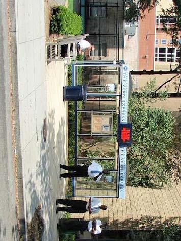
50
51

52
 Marvin Center/Gelman @ MC H St.")
53 Northern Route Southern Route 1) Marvin MC H St. 1) Marvin MC H St. 2) Aston 2) Thurston Hall 3) Corner of 19th & L St 3) Health and Wellness Center 4) Corner of Connecticut & L St 4) HOVA 5) Corner of 20th & Eye St 5) Columbia Center Driveway Source: Figure 2-6 Existing Colonial Express Routes North George Washington University Science and Engineering Complex Washington, DC


54 23 rd & H Streets North Leg 23 rd & H Streets South Leg Source: 23 rd & H Streets East Leg 23 rd & H Streets West Leg Figure 2-7 Pedestrian Crossing at the 23 rd Street/H Street Intersection George Washington University Science and Engineering Complex Washington, DC


55 23 rd & I Streets North Leg 23 rd & I Streets South Leg Source: 23 rd & I Streets East Leg 23 rd & I Streets West Leg Figure 2-8 Pedestrian Crossing at the 23 rd Street/I Street Intersection George Washington University Science and Engineering Complex Washington, DC


56 22 nd & H Streets North Leg 22 nd & H Streets South Leg Source: 22 nd & H Streets East Leg 22 nd & H Streets West Leg Figure 2-9 Pedestrian Crossing at the 22 nd Street/H Street Intersection George Washington University Science and Engineering Complex Washington, DC


57 22 nd & I Streets North Leg 22rd & I Streets South Leg Source: 22 nd & I Streets East Leg 22 nd & I Streets West Leg Figure 2-10 Pedestrian Crossing at the 22 nd Street/I Street Intersection George Washington University Science and Engineering Complex Washington, DC
58 I Street 23rd Street 22nd Street H Street Source: DC Pedestrian Master Plan Figure 2-11 Pedestrian Activity George Washington University Science and Engineering Complex Washington, DC 1 Pedestrian Injury 2-4 Pedestrian Injuries High Pedestrian Activity and High Pedestrian Deficiency Low Pedestrian Activity and High Pedestrian Deficiency North

59 I Street 23rd Street 22nd Street H Street Source: DC Bicycle Master Plan Figure 2-12 Bicycle Levels of Service George Washington University Science and Engineering Complex Washington, DC Bicycle LOS A Bicycle LOS B Bicycle LOS C Bicycle LOS D Bicycle LOS E Bicycle LOS F North

60 Site Source: Figure 2-13 Capital Bikeshare Locations Current Capital Bikeshare Locations Planned Capital Bikeshare Locations North George Washington University Science and Engineering Complex Washington, DC

61 Site Source: Figure 2-14 Zipcar Locations Zipcar Locations North George Washington University Science and Engineering Complex Washington, DC
62 A. No Standing or Parking Anytime B. No Standing or Parking 7-9:30 AM 4-6:30 PM Monday Friday C. No Standing or Parking Anytime D. No Standing or Parking 7-9:30 AM 4-6:30 PM Monday Friday E. Two Hour Parking 9:30 AM 4:00 PM Monday Saturday F. No Standing or Parking 7-9:30 AM 4-6:30 PM Monday Friday G. Two Hour Parking 9:30 AM 4:00 PM Monday Saturday H. No Parking I. Two Hour Parking Limit In Zone 2 7 AM 8:30 PM Monday Friday Zone 2 Excepted J. Two Hour Parking Limit In Zone 2 7 AM 8:30 PM Monday Friday Zone 2 Excepted K. Two Hour Parking 9:30 AM 4 PM Monday - Friday 7:00 AM 6:30 PM Saturday No Time Limit 6:30 PM 10 PM Monday Saturday Pay to Park L. No Parking M. Two Hour Parking 9:30 AM 4 PM Monday - Friday 7:00 AM 6:30 PM Saturday No Time Limit 6:30 PM 10 PM Monday Saturday Pay to Park N. No Standing or Parking 7 AM - 6:30 PM Monday Friday O. No Standing or Parking 7 AM - 6:30 PM Monday Friday P. No Parking Q. No Standing or Parking 7 AM - 9:30 AM Monday Friday R. Two Hour Parking 9:30 AM 10 PM Monday Friday S. No Standing or Parking 7 AM - 9:30 AM Monday Friday T. Two Hour Parking 9:30 AM 10 PM Monday Friday U. No Standing or Parking Anytime V. No Standing or Parking Metro Bus Zone W. No Standing or Parking Metro Bus Zone X. No Standing or Parking 4 PM to 6:30 PM Monday Friday Y. Two Hour Parking 7 AM 10 PM Monday Saturday Z. Back In-Pull Out Parking 8:00 AM 2:00 PM Sunday Only
63
64
65
66
67
68
69
70

71 Source: Ballinger Figure 5-1 Existing versus Proposed Curb Parking Inventory North George Washington University Science and Engineering Complex Washington, DC

72 Source: Ballinger Figure 5-2 Proposed Bicycle Parking Bicycle Parking North George Washington University Science and Engineering Complex Washington, DC
MEMORANDUM INTRODUCTION DESCRIPTION OF PROPOSED REDEVELOPMENT. District of Columbia Zoning Commission. Jami L. Milanovich, P.E.
 MEMORANDUM TO: FROM: District of Columbia Zoning Commission Jami L. Milanovich, P.E. DATE: December 21, 2010 RE: George Washington University Proposed School of Public Health and Health Services Square
THE GEORGE WASHINGTON UNIVERSITY SCHOOL OF PUBLIC HEALTH AND HEALTH SERVICES TRANSPORTATION IMPACT STUDY WASHINGTON, D.C.
 THE GEORGE WASHINGTON UNIVERSITY SCHOOL OF PUBLIC HEALTH AND HEALTH SERVICES TRANSPORTATION IMPACT STUDY WASHINGTON, D.C. Submitted on behalf of: The George Washington University Prepared by: Wells + Associates,
THE GEORGE WASHINGTON UNIVERSITY SITE 75A TRANSPORTATION IMPACT STUDY WASHINGTON, DC
 THE GEORGE WASHINGTON UNIVERSITY SITE 75A TRANSPORTATION IMPACT STUDY WASHINGTON, DC Submitted on behalf of: The George Washington University Prepared by: Wells + Associates, Inc. February 2012 TABLE OF
THE GEORGE WASHINGTON UNIVERSITY SITE 75A REVISED TRANSPORTATION IMPACT STUDY WASHINGTON, DC
 THE GEORGE WASHINGTON UNIVERSITY SITE 75A REVISED TRANSPORTATION IMPACT STUDY WASHINGTON, DC Submitted on behalf of: The George Washington University Prepared by: Wells + Associates, Inc. September 2012
Existing Transportation System
 < Open for Additional Text Transportation System Existing Transportation System This section describes vehicular transportation associated with Children s. transportation are described in a separate section
GW MOUNT VERNON CAMPUS TRANSPORTATION IMPACT STUDY WASHINGTON, D.C.
 GW MOUNT VERNON CAMPUS TRANSPORTATION IMPACT STUDY WASHINGTON, D.C. Submitted on behalf of: The George Washington University Prepared by: Wells + Associates, Inc. Jami L. Milanovich, P.E. Jorjean M. Stanton
Transportation-Demand Management Community Presentation
 Transportation-Demand Management Community Presentation American University Office of Risk, Safety and Transportation programs Thursday, June 7, 2018 Program Objectives Improve transportation options for
HENDERSON DEVELOPMENT 213, 217, 221, 221 ½, 223 HENDERSON AVENUE and 65 TEMPLETON STREET OTTAWA, ONTARIO TRANSPORTATION OVERVIEW.
 HENDERSON DEVELOPMENT 213, 217, 221, 221 ½, 223 HENDERSON AVENUE and 65 TEMPLETON STREET OTTAWA, ONTARIO TRANSPORTATION OVERVIEW Prepared for: 2294170 Ontario Inc. February 2, 2017 117-652 Report_1.doc
Existing Transportation System
 < Please Open Page for Additional Text Transportation System Existing Transportation System This section describes vehicular transportation associated with Children s. Pedestrian and other nonmotorized
Comments EXECUTIVE SUMMARY
 Comments 1. Under any Alternatives, MCDOT should provide better at-grade pedestrian crossing of Georgia Avenue and Forest Glen Road, including improved crosswalks with wider medians and adequate signal
CHAPTER 1: INTRODUCTION
 CHAPTER 1: INTRODUCTION 7 8 UNION STATION GEORGETOWN: ALTERNATIVES ANALYSIS for PREMIUM TRANSIT SERVICE Premium transit is high-quality transit that offers improved reliability and speed, and includes
TRANSPORTATION ANALYSIS REPORT US Route 6 Huron, Erie County, Ohio
 TRANSPORTATION ANALYSIS REPORT US Route 6 Huron, Erie County, Ohio December 12, 2012 Prepared for: The City of Huron 417 Main Huron, OH 44839 Providing Practical Experience Technical Excellence and Client
Magnolia Place. Traffic Impact Analysis. Prepared for: City of San Mateo. Prepared by: Hexagon Transportation Consultants, Inc.
 Magnolia Place Traffic Impact Analysis Prepared for: City of San Mateo Prepared by: Hexagon Transportation Consultants, Inc. Updated January 4, 2010 Table of Contents 1. Introduction...1 2. Existing Conditions...6
Shockoe Bottom Preliminary Traffic and Parking Analysis
 Shockoe Bottom Preliminary Traffic and Parking Analysis Richmond, Virginia August 14, 2013 Prepared For City of Richmond Department of Public Works Prepared By 1001 Boulders Pkwy Suite 300, Richmond, VA
MEMORANDUM. Charlotte Fleetwood, Transportation Planner
 MEMORANDUM Date: Updated August 22, 2017 To: Organization: Charlotte Fleetwood, Transportation Planner Boston Transportation Department From: Jason DeGray, P.E., PTOE, Regional Director of Engineering
VIVA RETIREMENT COMMUNITIES OAKVILLE TRAFFIC IMPACT STUDY
 VIVA RETIREMENT COMMUNITIES OAKVILLE TRAFFIC IMPACT STUDY VIVA RETIREMENT COMMUNITIES OAKVILLE TRAFFIC IMPACT STUDY DECEMBER 2012 READ, VOORHEES & ASSOCIATES TORONTO, ONTARIO Read, Voorhees & Associates
Appendix C. NORTH METRO STATION AREA TRAFFIC IMPACT STATEMENT 88th Avenue Station
 Appendix C NORTH METRO STATION AREA TRAFFIC IMPACT STATEMENT 88th Avenue Station Prepared for: Regional Transportation Department and URS Corporation as part of the North Metro EIS David Evans and Associates,
TECHNICAL MEMORANDUM. Introduction
 TECHNICAL MEMORANDUM To: From: John M. Welsh Chris Furlong AHC, Inc. Andrew T. Smith, P.E. Edward Y. Papazian, P.E. Kimley-Horn and Associates, Inc. Date: July 6, 2017 Subject: 200 9 th reet South Redevelopment
MEDICAL/OFFICE BUILDING 1637 BANK STREET OTTAWA, ONTARIO TRANSPORTATION OVERVIEW. Prepared for:
 MEDICAL/OFFICE BUILDING 1637 BANK STREET OTTAWA, ONTARIO TRANSPORTATION OVERVIEW Prepared for: 2434984 Ontario Inc. 13-5510 Canotek Road Ottawa, Ontario K1J 9J5 June 4, 2015 115-613 Report_2.doc D. J.
Presentation to Media. February 27, 2008
 Anacostia Waterfront Nationals Ballpark Transportation Management Plan Presentation to Media February 27, 2008 Overarching Goals of DDOT s Ballpark TMP Organize and manage traffic to ensure pedestrian
EUCLID AVENUE PARKING STUDY CITY OF SYRACUSE, ONONDAGA COUNTY, NEW YORK
 EUCLID AVENUE PARKING STUDY CITY OF SYRACUSE, ONONDAGA COUNTY, NEW YORK CITY OF SYRACUSE DEPARTMENT OF PUBLIC WORKS 1200 CANAL STREET EXTENSION SYRACUSE, NEW YORK 13210 DRAFT REPORT DATE: November 13,
Preliminary Transportation Analysis
 Preliminary Transportation Analysis Goals of a Robust, Multimodal Transportation Network Safe Accessible/Connected Efficient Comfortable Context-Sensitive Motor Vehicle: Continue to analyze the data to
CPC Parking Lot Riverside Drive. Transportation Rationale
 CPC Parking Lot Transportation Rationale Prepared By: NOVATECH Suite 200, 240 Michael Cowpland Drive Ottawa, Ontario K2M 1P6 September 2015 Novatech File: 114093 Ref: R-2015-153 Table of Contents 1.0 INTRODUCTION...
See Figure 38, Existing Nonmotorized Connections.
 Nonmotorized Connections Existing Nonmotorized Connections Pedestrian, vehicle and bike traffic access and movements are confined primarily to Penny Drive on campus. Due to the steep slope along the length
List of Exhibits...ii
 One Brickell Traffic Study TABLE OF CONTENTS List of Exhibits...ii EXECUTIVE SUMMARY...1 1. INTRODUCTION...2 1.1 Study Area...2 1.2 Study Objective...5 2. EXISTING TRAFFIC CONDITIONS...6 2.1 Data Collection...6
M Street SW-Southeast Federal Center
 Section 1 M Street SW-Southeast Federal Center 1 2 M Street SW M Street SW and the Southeast Federal Center, located in Southeast and Southwest Washington, DC, comprise an activity center area that is
Development of Arlington County s Marked Crosswalk Guidelines. Jon Lawler, P.E. Design Engineer Arlington County, VA
 Development of Arlington County s Marked Crosswalk Guidelines Jon Lawler, P.E. Design Engineer Arlington County, VA April 13, 2015 Transportation System Users Residents Estimated 215,000 in 2014 Lowest
Transportation Impact Study for Abington Terrace
 Transportation Impact Study for Abington Terrace Abington Township, Montgomery County, PA Sandy A. Koza, P.E., PTOE PA PE License Number PE059911 Prepared by McMahon Associates, Inc. 425 Commerce Drive,
OFFICE/RETAIL DEVELOPMENT 1625 BANK STREET OTTAWA, ONTARIO TRANSPORTATION BRIEF. Prepared for: Canada Inc.
 OFFICE/RETAIL DEVELOPMENT 1625 BANK STREET OTTAWA, ONTARIO TRANSPORTATION BRIEF Prepared for: 9402209 Canada Inc. December 15, 2015 115-625 Report_2.doc D. J. Halpenny & Associates Ltd. Consulting Transportation
HOLIDAY INN HOTEL 235 KING EDWARD AVENUE CITY OF OTTAWA TRANSPORTATION BRIEF. Prepared for:
 HOLIDAY INN HOTEL 235 KING EDWARD AVENUE CITY OF OTTAWA TRANSPORTATION BRIEF Prepared for: Momentum Planning & Communications 1165 Greenlawn Crescent Ottawa, ON K1L 6C2 June 29, 2015 115-618 Brief_1.doc
Roads and Vehicular Traffic Design Principles. Roads and Vehicular Traffic Recommendations
 CIRCULATION AND PARKING roads and vehicular traffic The Campus Master Plan updates the campus transportation network through a multi-modal approach that encourages walking and biking while improving vehicular
Ownership Lots 17 & 18 (Part of Lot 14), Montgomery Auto Sales Park
, Montgomery Auto Sales Park") Traffic Impact Analysis Ownership Lots 17 & 18 (Part of Lot 14), Montgomery Auto Sales Park Silver Spring, MD Lot 17: Site Plan No. 821413 Lot 18: Site Plan No. 821414 Filing Number: 13-TS-1198527A Prepared
Traffic Impact Analysis Ownership Lots 17 & 18 (Part of Lot 14), Montgomery Auto Sales Park Silver Spring, MD Lot 17: Site Plan No. 821413 Lot 18: Site Plan No. 821414 Filing Number: 13-TS-1198527A Prepared
PenPlace SPRC #6. September 27, DRAFT
 PenPlace SPRC #6 1 Agenda Site and Project Overview Multiple Transportation Options Traffic Analysis Neighborhood Analysis Street Network Street Sections/Sidewalk Width Pedestrian/Bicycle Circulation Secure
TRAFFIC MANAGEMENT PLAN
 292 84 140440 TRAFFIC MANAGEMENT PLAN The purpose of the Traffic Management Plan (TMP) is to have established procedures for traffic flow and circulation around the elementary school related to student
Arlington Public Schools Thomas Jefferson Site Evaluation Transportation Networks. Thomas Jefferson Working Group Meeting #6 November 10, 2014
 Arlington Public Schools Thomas Jefferson Site Evaluation Transportation Networks Thomas Jefferson Working Group Meeting #6 November 10, 2014 2 3 INTRODUCTION 4 Goal of our work: Identify and assess multi-modal
Paul VI Redevelopment. Traffic Impact Study
 ATTACHMENT 5 Paul VI Redevelopment Traffic Impact Study April 18, 2017 PAUL VI REDEVELOPMENT TRAFFIC IMPACT STUDY CITY OF FAIRFAX, VIRGINIA Prepared for: IDI GROUP COMPANIES Prepared by: Wells + Associates,
Meadow Woods Elementary School
 Drag and drop pic and stretch/crop to the limits of the blue rectangle (delete this text box) Meadow Woods Elementary School Drag and drop pic and stretch/crop to the limits of the blue rectangle (delete
14 TH STREET TRANSPORTATION & STREETSCAPE DESIGN STUDY PLAN B PLAN B TRANSPORTATION & STREETSCAPE RECOMMENDATIONS
 14 TH STREET TRANSPORTATION & STREETSCAPE DESIGN STUDY PLAN B PLAN B TRANSPORTATION & STREETSCAPE RECOMMENDATIONS 141 Symbols Recommendations - Southern End of 14th Street Study Area Streetscape Each icon
Employment 8,881 17,975 9,094. Households 18,990 31,936 12,946
 This section describes the future transportation environment of the UW Tacoma campus and surrounding area. A description of the future conditions on campus in terms of the street system, traffic and intersection
QUICKIE C STORE AND GAS BAR 1780 HERON ROAD OTTAWA, ONTARIO TRANSPORTATION BRIEF. Prepared for:
 QUICKIE C STORE AND GAS BAR 1780 HERON ROAD OTTAWA, ONTARIO TRANSPORTATION BRIEF Prepared for: Quickie Convenience Stores Larny Holdings Ltd. c/o PBC Group April 15, 2015 115-615 Report_1.doc D. J. Halpenny
Memorandum. Sunday, July 13, Saturday, July 19, 2014
 Memorandum To: David Lowin, Brooklyn Bridge Park Corporation From: Daniel Schack, AICP, PTP Date: Re: Brooklyn Bridge Park Pier 5/6 Loop Road Traffic Study Project No: 14-01-2407 At the request of Brooklyn
5858 N COLLEGE, LLC N College Avenue Traffic Impact Study
 5858 N COLLEGE, LLC nue Traffic Impact Study August 22, 2016 Contents Traffic Impact Study Page Preparer Qualifications... 1 Introduction... 2 Existing Roadway Conditions... 5 Existing Traffic Conditions...
9 Leeming Drive Redevelopment Ottawa, ON Transportation Brief. Prepared By: Stantec Consulting Ltd.
 9 Leeming Drive Redevelopment Ottawa, ON Transportation Brief Prepared By: Stantec Consulting Ltd. TIA GUIDELINES CHECKLIST Report Context Municipal Address Comment: Section 1.1 Location relative to major
INDUSTRIAL BUILDING 1660 COMSTOCK ROAD CITY OF OTTAWA TRANSPORTATION OVERVIEW. Prepared for:
 INDUSTRIAL BUILDING 1660 COMSTOCK ROAD CITY OF OTTAWA TRANSPORTATION OVERVIEW Prepared for: Simluc Contractors Limited 2550 Blackwell Street, Ottawa K1B 5R1 October 18, 2013 113-584 Overview_1.doc D. J.
CURBSIDE ACTIVITY DESIGN
 5 CURBSIDE ACTIVITY DESIGN This chapter provides design guidance for separated bike lanes adjacent to curbside activities including parking, loading and bus stops. Typical configurations are presented
CAMPUS MASTER PLAN UPDATE
 FLORIDA INTERNATIONAL UNIVERSITY CAMPUS MASTER PLAN UPDATE 2010-2020 Work Session #2 FOCUS GROUP 6 2 Group 6 Transportation Typical items to be discussed at each Focus Group Provide overview of Campus
Hidden Oaks Elementary School
 Hidden Oaks Elementary School SCHOOL ROUTE PLAN For HIDDEN OAKS ELEMENTARY SCHOOL LOCATION 13 ORANGE COUNTY Prepared for: ORANGE COUNTY SCHOOL ASSESSMENT PROGRAM ORANGE COUNTY PUBLIC WORKS Traffic Engineering
U.S. Equities Realty. Luay R. Aboona, PE Principal. Traffic and Parking Evaluation Fourth Presbyterian Church of Chicago Chicago, Illinois
 9575 West Higgins Road, Suite 100 Rosemont, Illinois 60018 p: 847-518-9990 f: 847-518-9987 MEMORANDUM TO: FROM: Suzanne Kahle U.S. Equities Realty Kelly K. Conolly, PE Consultant Luay R. Aboona, PE Principal
SECTION 1 - TRAFFIC PLANNING
 SECTION 1 - TRAFFIC PLANNING 1.1 TRAFFIC OPERATIONS 1.1.1 Roadway Functional Classification The Multnomah County Comprehensive Framework Plan s Policy 34: Trafficways and the Functional Classification
5/7/2013 VIA . RE: University Village Safeway Expansion (P13-019)
") 5/7/2013 VIA EMAIL David Hung, Associate Planner Community Development Department, Current Planning Division City of Sacramento 300 Richards Boulevard, 3 rd Floor Sacramento, CA 95811 RE: University Village
5/7/2013 VIA EMAIL David Hung, Associate Planner Community Development Department, Current Planning Division City of Sacramento 300 Richards Boulevard, 3 rd Floor Sacramento, CA 95811 RE: University Village
OTTAWA TRAIN YARDS PHASE 3 DEVELOPMENT CITY OF OTTAWA TRANSPORTATION IMPACT STUDY. Prepared for:
 OTTAWA TRAIN YARDS PHASE 3 DEVELOPMENT CITY OF OTTAWA TRANSPORTATION IMPACT STUDY Prepared for: The Ottawa Train Yards Inc. 223 Colonnade Road South, Suite 212 Nepean, Ontario K2E 7K3 January 17, 2012
Transportation, Parking & Roads
 Transportation, Parking & Roads Design Carolina North as a walkable community Design the transportation system and development patterns (i.e., urban design elements such as density, building design, mix
Chapter 4 Traffic Analysis
 Chapter 4 Traffic Analysis PURPOSE The traffic analysis component of the K-68 Corridor Management Plan incorporates information on the existing transportation network, such as traffic volumes and intersection
Gateway Transportation Study
 Gateway Transportation Study Amherst, Massachusetts SUBMITTED TO University of Massachusetts Amherst Town of Amherst SUBMITTED BY Vanasse Hangen Brustlin, Inc. Watertown, Massachusetts March 213 Back of
CRYSTAL HOUSE III TRAFFIC IMPACT ANALYSIS ARLINGTON COUNTY, VA
 CRYSTAL HOUSE III TRAFFIC IMPACT ANALYSIS ARLINGTON COUNTY, VA Prepared for: Roseland, A Mack-Cali Company Prepared by: Wells + Associates, Inc. Michael R. Pinkoske, PTP Henry C. Clarke, EIT 70.97.660
ELEMENT 11 TRANSPORTATION ELEMENT
 ELEMENT 11 TRANSPORTATION ELEMENT TRANSIT, CIRCULATION, PARKING, PEDESTRIAN, & NON-VEHICULAR CIRCULATION Introduction The following narrative describes the concepts on which the transportation plan is
INDUSTRIAL BUILDING 3009 HAWTHORNE ROAD CITY OF OTTAWA TRANSPORTATION OVERVIEW REVISED. Prepared for: Canada Inc.
 INDUSTRIAL BUILDING 3009 HAWTHORNE ROAD CITY OF OTTAWA TRANSPORTATION OVERVIEW REVISED Prepared for: 7849648 Canada Inc. Octiober 1, 2015 114-598 Overview_2.doc D. J. Halpenny & Associates Ltd. Consulting
CITY OF COCOA BEACH 2025 COMPREHENSIVE PLAN. Section VIII Mobility Element Goals, Objectives, and Policies
 CITY OF COCOA BEACH 2025 COMPREHENSIVE PLAN Section VIII Mobility Element Goals, Objectives, and Policies Adopted August 6, 2015 by Ordinance No. 1591 VIII MOBILITY ELEMENT Table of Contents Page Number
C C C
 C-012-001 Thank you for your support for the creation of new public space and nonmotorized access between downtown and the waterfront through the Overlook Walk, the East-West Connections, and the Promenade.
TRAFFIC IMPACT ANALYSIS
 TRAFFIC IMPACT ANALYSIS FOR THE CHAMPAIGN UNIT#4 SCHOOL DISTRICT PROPOSED HIGH SCHOOL (SPALDING PARK SITE) IN THE CITY OF CHAMPAIGN Final Report Champaign Urbana Urbanized Area Transportation Study 6/24/2014
Metropolitan Park 4/5
 Traffic Impact Study and Transportation Management Plan Metropolitan Park 4/ Arlington County, VA July 3, 0 Prepared by: 40 Connecticut Avenue Suite 00 Washington, DC 003 Tel: 0.9. Fax: 0.. 394 Centreville
MEETING FACILITY 2901 GIBFORD DRIVE CITY OF OTTAWA TRANSPORTATION BRIEF. Prepared for: Holiday Inn Express 2881 Gibford Drive Ottawa, ON K1V 2L9
 MEETING FACILITY 2901 GIBFORD DRIVE CITY OF OTTAWA TRANSPORTATION BRIEF Prepared for: Holiday Inn Express 2881 Gibford Drive Ottawa, ON K1V 2L9 December 18, 2012 112-566 Brief_1.doc D. J. Halpenny & Associates
Table of Contents FIGURES TABLES APPENDICES. Traffic Impact Study Hudson Street Parking Garage MC Project No.: A Table of Contents
 Traffic Impact Study Hudson Street Parking Garage MC Project No.: 151714A Table of Contents Table of Contents I. INTRODUCTION... 2 II. EXISTING CONDITIONS... 5 III. 215 EXISTING TRAFFIC CONDITIONS... 6
4. ENVIRONMENTAL IMPACT ANALYSIS 9. TRANSPORTATION AND TRAFFIC
 4. ENVIRONMENTAL IMPACT ANALYSIS 9. TRANSPORTATION AND TRAFFIC 4.9.1 INTRODUCTION The following section addresses the Proposed Project s impact on transportation and traffic based on the Traffic Study
Henderson Avenue Mixed-Use Development
 Zoning Case: Z145-3 Traffic Impact Analysis Henderson Avenue Mixed-Use Development Dallas, TX October 26 th, 216 Kimley-Horn and Associates, Inc. Dallas, Texas Project #644827 Registered Firm F-928 Traffic
Set of plans containing details for game day operations of the Ballpark. Plans set forth the responsibilities and the specific actions of:
 What is the TOPP? Set of plans containing details for game day operations of the Ballpark. Plans set forth the responsibilities and the specific actions of: Ballpark management, District Department of
COMMERCIAL DEVELOPMENT 2015 ROBERTSON ROAD OTTAWA, ONTARIO TRANSPORTATION BRIEF. Prepared for:
 COMMERCIAL DEVELOPMENT 2015 ROBERTSON ROAD OTTAWA, ONTARIO TRANSPORTATION BRIEF Prepared for: First Bay Properties Inc. 311 Richmond Road, Suite 203 Ottawa, ON K1Z 6X3 August 8, 2017 117-663 Brief_1.doc
SETTINGS AND OPPORTUNITIES MOBILITY & ACCESS
 7 mobility & access how do people use el camino what is it like to drive on el camino/to park along el camino what is the pedestrian experience like what is the role of transit along the corridor what
Prepared For: Shieldbay Developments Inc. c/o Matson, McConnell Ltd. 2430A Bloor Street West Toronto, Ontario M6S 1P9.
 Prepared For: Shieldbay Developments Inc. c/o Matson, McConnell Ltd. 2430A Bloor Street West Toronto, Ontario M6S 1P9 Prepared By: URS Canada Inc. 4 th Floor, 30 Leek Crescent Richmond Hill, Ontario L4B
FAIRFIELD INN & SUITES HOTEL 135 THAD JOHNSON PRIVATE OTTAWA TRANSPORTATION BRIEF. Prepared for:
 FAIRFIELD INN & SUITES HOTEL 135 THAD JOHNSON PRIVATE OTTAWA TRANSPORTATION BRIEF Prepared for: Bona Building & Management Co. Ltd. Place Vanier, 333 North River Road Vanier, Ontario K1L 8B9 August 12,
Drag and drop pic and stretch/crop to the limits of the blue rectangle (delete this text box) Maxey Elementary School
 Maxey Elementary School") Drag and drop pic and stretch/crop to the limits of the blue rectangle (delete this text box) Maxey Elementary School SCHOOL ROUTE PLAN For MAXEY ELEMENTARY SCHOOL LOCATION 33 ORANGE COUNTY Prepared for:
Drag and drop pic and stretch/crop to the limits of the blue rectangle (delete this text box) Maxey Elementary School SCHOOL ROUTE PLAN For MAXEY ELEMENTARY SCHOOL LOCATION 33 ORANGE COUNTY Prepared for:
City of Hyattsville. Citywide Traffic Study and Transportation Plan. Sabra, Wang & Associates. February, 2010
 City of Hyattsville Citywide Traffic Study and Transportation Plan February, 2010 Outline Existing Conditions Recommendations Future Conditions Traffic Growth Development Capacity and Level of Service
Transportation 6. A. Transit Center Circulation and Access. 1. Transit Center Circulation
 Transportation 6 This chapter describes the transportation system in and around the Hillsdale Station Area, with a focus on the Transit Center at the relocated Hillsdale Caltrain Station. The transportation
APPENDIX E: Transportation Technical Report
 New Jersey Pennsylvania Lackawanna Cut-Off Passenger Rail Service Reston Project Environmental Assessment APPENDIX E: Transportation Technical Report E.1 Introduction As part of the overall environmental
ALLEY 24 TRAFFIC STUDY
 ALLEY 24 TRAFFIC STUDY in City of Frostburg, Maryland January 2013 3566 Teays Valley Road Hurricane, WV Office: (304) 397-5508 www.denniscorporation.com Alley 24 Traffic Study January 2013 Frostburg, Maryland
July 5, Arthur R. Ware, Jr. Elementary School 2017 Safe Routes to School Walkabout Report
 July 5, 2017 Arthur R. Ware, Jr. Elementary School 2017 Safe Routes to School Walkabout Report 1 Walkabout Report Introduction On April 28, 2017, City, School, and SAWMPO staff met to conduct a Safe Routes
Southwest Bus Rapid Transit (SW BRT) Functional Planning Study - Executive Summary January 19 LPT ATTACHMENT 2.
 Functional Planning Study - Executive Summary January 19 LPT ATTACHMENT 2.") Southwest Bus Rapid Transit (SW BRT) Functional Planning Study - Executive Summary 2011 January 19 1 of 19 Introduction This executive summary presents the results of the Southwest Bus Rapid Transit (SW
Southwest Bus Rapid Transit (SW BRT) Functional Planning Study - Executive Summary 2011 January 19 1 of 19 Introduction This executive summary presents the results of the Southwest Bus Rapid Transit (SW
NM-POLICY 1: Improve service levels, participation, and options for non-motorized transportation modes throughout the County.
 Transportation PRINCE WILLIAM COUNTY 2008 COMPREHENSIVE PLAN NON-MOTORIZED PLAN CONTENTS Goals, Policies, and Action Strategies Table 4 (Bike Facility Classifications and Descriptions) Table 5 (Bike Facility
Corporate. Report COUNCIL DATE: May 25, 1998 NO: R1500 REGULAR COUNCIL. TO: Mayor & Council DATE: April 27, 1998
 R1500 : Traffic Safety at 25 Avenue and 128 Street Intersection Corporate NO: R1500 Report COUNCIL DATE: May 25, 1998 REGULAR COUNCIL TO: Mayor & Council DATE: April 27, 1998 FROM: General Manager, Engineering
Pedestrian & Bicycle Safety Innovations & Applications
 Pedestrian & Bicycle Safety Innovations & Applications County Engineers Association of Maryland Spring, 2017 Conference May 25, 2017 George Branyan Pedestrian Program Coordinator District Department of
INTRODUCTION THOROUGHFARE SYSTEM CLASSIFICATIONS
 INTRODUCTION The thoroughfare plan will assist public officials in the development of a specialized system for efficient and safe movement of vehicular traffic while minimizing potential conflicts with
City of Gainesville Transportation/Roadway Needs PROJECT SUMMARY
 A1 Roadway Resurfacing $23,846,000 TYPE: Preservation of existing system Roadway resurfacing A2 Signal Replacement $6,000,000 TYPE: Preservation of existing system Replace traffic signals. B1 W 6th St
City of Wayzata Comprehensive Plan 2030 Transportation Chapter: Appendix A
 A1. Functional Classification Table A-1 illustrates the Metropolitan Council s detailed criteria established for the functional classification of roadways within the Twin Cities Metropolitan Area. Table
TRAFFIC IMPACT ANALYSIS OF PROPOSED CHESTNUT HILL COLLEGE MASTER PLAN DEVELOPMENT
 TRAFFIC IMPACT ANALYSIS OF PROPOSED CHESTNUT HILL COLLEGE MASTER PLAN DEVELOPMENT Prepared by Orth-Rodgers & Associates, Inc. December 14, 2009 Updated November 9, 2010 230 South Broad Street Philadelphia
Virginia Hospital Center Expansion
 Virginia Hospital Center Expansion Site Plan Amendment (SP #177) SPRC Meeting #2 Dennis Sellin Arlington County DES/Transportation February 5, 2018 1 Arlington County Master Transportation Plan Goals Move
Traffic Impact Memorandum. May 22, 2018
 BISHOP PROFESSIONAL DEVELOPMENT BUILDING Proposed Land-use Change & Parking Modification 3601 SW 31st Street Topeka, Kansas 66614 CFS Project No. 185077 Traffic Impact Memorandum May 22, 2018 Prepared
Harrah s Station Square Casino
 Transportation Analysis Harrah s Station Square Casino Pittsburgh, Pennsylvania Submitted To: City of Pittsburgh and Pennsylvania Gaming Control Board Prepared By: DKS Associates GAI Consultants December
7/23/2017 VIA . Michael Hanebutt City of Sacramento Community Development Department 300 Richards Boulevard, 3 rd Floor Sacramento, CA 95811
 7/23/2017 VIA EMAIL Michael Hanebutt City of Sacramento Community Development Department 300 Richards Boulevard, 3 rd Floor Sacramento, CA 95811 RE: 65 th Street Apartments (DR17-220) Dear Mr. Hanebutt:
Highway 49, Highway 351 and Highway 91 Improvements Feasibility Study Craighead County
 Highway 49, Highway 351 and Highway 91 Improvements Feasibility Study Craighead County Executive Summary March 2015 Highway 49, Highway 351 and Highway 91 Improvements Feasibility Study Craighead County
Orange Center Elementary School
 Drag and drop pic and stretch/crop to the limits of the blue rectangle (delete this text box) Orange Center Elementary School Drag and drop pic and stretch/crop to the limits of the blue rectangle (delete
Chapter 2: Standards for Access, Non-Motorized, and Transit
 Standards for Access, Non-Motorized, and Transit Chapter 2: Standards for Access, Non-Motorized, and Transit The Washtenaw County Access Management Plan was developed based on the analysis of existing
CITY OF LOS ANGELES INTER-DEPARTMENTAL MEMORANDUM
 CITY OF LOS ANGELES INTER-DEPARTMENTAL MEMORANDUM Date: April 1, 219 To: Honorable City Council c/o City Clerk, Room 395, City Hall Attention: Honorable Mike Bonin, Chair, Transportation Committee From:
Ref. No February 19, Ms. Ashley Blissett, P. Eng., Senior Development Engineer City of Halifax PO Box 1749 HALIFAX NS B3J 3A5
 Ref. No. 151-00564-01 February 19, 2015 Ms. Ashley Blissett, P. Eng., Senior Development Engineer City of Halifax PO Box 1749 HALIFAX NS B3J 3A5 RE: Traffic Impact Statement, Proposed Multi-Tenant Residential
City of Elizabeth City Neighborhood Traffic Calming Policy and Guidelines
 City of Elizabeth City Neighborhood Traffic Calming Policy and Guidelines I. Purpose: The City of Elizabeth City is committed to ensure the overall safety and livability of residential neighborhoods. One
Walmart (Store # ) 60 th Street North and Marion Road Sioux Falls, South Dakota
 60 th Street North and Marion Road Sioux Falls, South Dakota") Walmart (Store #4865-00) 60 th Street North and Marion Road Sioux Falls, South Dakota Prepared for: Wal-Mart Stores, Inc. Bentonville, Arkansas Prepared by: Kimley-Horn and Associates, Inc. ã2013 Kimley-Horn
Walmart (Store #4865-00) 60 th Street North and Marion Road Sioux Falls, South Dakota Prepared for: Wal-Mart Stores, Inc. Bentonville, Arkansas Prepared by: Kimley-Horn and Associates, Inc. ã2013 Kimley-Horn
Arlington s Master Transportation Plan
 Arlington s Master Transportation Plan The Master Transportation Plan (MTP) Adopted in eight parts Goals & Policies element and MTP Map adopted in 2007 Bicycle, Pedestrian and Demand and Systems Management
WASHINGTON METROPOLITAN AREA TRANSIT AUTHORITY. Final Report January 2006
 M metro WASHINGTON METROPOLITAN AREA TRANSIT AUTHORITY STADIUM-ARMORY ARMORY STATION AREA PLANNING STUDY Final Report January 2006 Washington Metropolitan Area Transit Authority Department of Planning
URBAN QUARRY HEADQUARTERS 2717 STEVENAGE DRIVE CITY OF OTTAWA TRANSPORTATION OVERVIEW. Prepared for: Urban Quarry 4123 Belgreen Drive, Ottawa K1G 3N2
 URBAN QUARRY HEADQUARTERS 2717 STEVENAGE DRIVE CITY OF OTTAWA TRANSPORTATION OVERVIEW Prepared for: Urban Quarry 4123 Belgreen Drive, Ottawa K1G 3N2 February 27, 2014 113-584 Overview_1.doc D. J. Halpenny
The DC Pedestrian Master Plan
 The DC Pedestrian Master Plan September 28, 2010 George Branyan Pedestrian Program Coordinator District Department of Transportation Presentation Agenda Scope of the Plan Methodology Recommendations Implementation
TRAVEL PLAN: CENTRAL EUROPEAN UNIVERSITY CAMPUS REDEVELOPMENT PROJECT TRAVEL PLAN. Central European University Campus Redevelopment Project.
 TRAVEL PLAN Central European University Campus Redevelopment Project Page 1 Table of Contents Introduction... 3 Background... 7 Building Users... 7 Transportation in Community Consultation... 7 Summary