PROPOSED RESIDENTIAL DEVELOPMENT. Transportation Impact Study Update Highway 2 CLARINGTON, ONTARIO. May, 2017 Project No: NT
|
|
|
- Lauren Lewis
- 5 years ago
- Views:
Transcription
1 Consulting Engineers A Division of NextEng Consulting Group Inc. Transportation Planning Traffic Impact Assessment Parking Assessment Site Access Design & Review Site Servicing and Grading Stormwater Management Municipal Road Design Transportation Impact Study Update PROPOSED RESIDENTIAL DEVELOPMENT 1475 Highway 2 CLARINGTON, ONTARIO May, 217 Project No: NT-15-88
2 A Division of NextEng Consulting Group Inc. May 16, 217 Mr. Carmine Crincoli High Street Courtice Inc. 21 Roysun Road, Unit 17 Woodbridge, ON L4L 8R3 Re: Transportation Impact Study Update Proposed Residential Development 1475 Highway 2, Town of Clarington (Clarington) ON Our Project No. NT NexTrans Consulting Engineers (A Division of NextEng Consulting Group Inc.) is pleased to present the enclosed Transportation Impact Study Update in support of the Official Plan Amendment, Zoning By-law Amendment and future Site Plan applications for the above noted property. The subject property is located at 1475 Highway 2, in the Town of Clarington (Courtice). The proposed residential development consists of approximately 47 to 464 residential units, in a mix of housing forms. This Transportation Impact Study Update has incorporated and addressed all comments received from the Region of Durham and Municipality of Clarington. The respective Traffic Impact Study Guidelines from both municipalities have been reviewed and reflected in this report Municipality of Clarington (TIS Guidelines, January 215) and Durham Region (TIS Guidelines Revised October 211). It should be noted that some of the requirements from both TIS Guidelines are related to more detail site plan application, as such, it is more appropriate to address those specific requirements at that time. The study concludes that the development proposal can adequately be accommodated by the existing transportation network with manageable traffic impact to the adjacent public roadways. A new traffic signal is strongly recommended for the proposed Street W/Highway 2 intersection to facilitate the proposed development. We trust the enclosed sufficiently addresses your needs. Should you have any questions, please do not hesitate to contact the undersigned. Yours truly, NEXTRANS CONSULTING ENGINEERS Richard Pernicky, CET, MITE Principal 1526 Yonge Street, Suite 24, Aurora, ON, L4G 1N4 Phone: Fax:
3 EXECUTIVE SUMMARY NexTrans Consulting Engineers (A Division of NextEng Consulting Group Inc.) was retained by High Street Courtice Inc. (the Client ) to undertake a Transportation Impact Study for Official Plan Amendment, Zoning By-law Amendment and eventually Site Plan applications in support of a proposed residential development. The subject property is generally located at Southeast corner of the Darlington Boulevard/Varcoe Road/Highway 2 intersection, in the Town of Clarington (Courtice) and are municipally known as 1475 Hwy 2. The purpose of this report update is to assess the impact of the revised proposed development proposal and to address the comments provided by the Region of Durham and the Town of Clarington. The respective Traffic Impact Study Guidelines from both municipalities have been reviewed and reflected in this report Municipality of Clarington (TIS Guidelines, January 215) and Durham Region (TIS Guidelines Revised October 211). It should be noted that some of the requirements from both TIS Guidelines are related to more detail site plan application, as such, it is more appropriate to address those specific site plan requirements at that time. Revised Development Proposal In the previous development proposal, the proposed development consisted of approximately 531 residential units, in a mix of housing forms such as townhouses, high-rise residential condominium units, rental apartments and four detached homes. The revised proposed development proposal has similar mix of housing form, including six single detached homes fronting onto Darlington Boulevard. However, the total numbers of units have been reduced to only 47 residential units, which represents about 12% reduction in development density. It is our understanding the latest site plan sees further reduction from 47 to 464. However, for purposes of this assessment, 47 units were utilized to represent a more conservative analysis. Development Access The proposed site plan has incorporated comments from the Region of Durham and Municipality of Clarington related to the site access arrangement. The development proposed two vehicular accesses: one right-in/right-out access onto Hwy 2 (Street X) and one full moves unsignalized access onto Hwy 2 (Street W). It is our understanding that the previously proposed Street Y onto Darlington Avenue is a temporary access and will be converted into a parkette with a pedestrian connection to the trail system. For this reason, the analysis in in this report has reflected the future conditions without the proposed the full moves unsignalized access onto Darlington Boulevard (Street Y). It should be noted that the six proposed single detached family units will still have its driveways fronting onto Darlington Boulevard, which is similar and compatible with the existing residential homes along Darlington Boulevard. The Old Kingston Road will remain to maintain the access to the existing house and the park. The proposed development will not have access to Old Kingston Road. Capacity Analysis The current development proposal is expected to generate 189 two-way trips (35 inbound and 154 outbound) during the weekday morning peak hour and 231 two-way trips (154 inbound and 77 outbound) during the afternoon peak hour. In addition, the proposed development also generates 21 two-way non-auto trips (4 inbound and 17 outbound) and 26 two-way non-auto trips (17 inbound and 9 outbound) during the weekday morning and afternoon peak hours, respectively. Under existing conditions, the study area intersections are currently operating at acceptable levels of service, with the exception of the westbound left turn at the Darlington Boulevard/Varcoe Road/Hwy 2 intersection during the afternoon NT (1475 Highway 2) May, 217 / Page i
4 peak hour. This particular movement is currently operating at level of service F with the average delay of one minute and half for each vehicle making westbound left turn. Under future background conditions, the intersections analyzed are expected to operate at acceptable levels of service during the morning peak hour. However, given that a 2% of background through growth traffic will be added to Highway 2, the study area intersection levels of service are expected to deteriorate during the afternoon peak hour, as compared to the existing traffic conditions. Noticeably, the eastbound shared through/right and westbound left turn at the Darlington Boulevard/Varcoe Road/Highway 2 intersection are expected to operate slightly over capacity during the afternoon peak hour due to the background traffic growth. Under future total traffic condition, the study area intersections are expected to operate with sufficient capacity during the morning peak hour. However, during the afternoon peak hour with the current signal timing and lane configurations, the Darlington Boulevard/Varcoe Road/Highway 2 signalized intersection, especially the left turn movements, are expected to operate at deteriorated levels of service similar to the future background conditions due to the background growth traffic and proposed development traffic. During the morning peak hour, the proposed development accesses (Street W and Street X) are expected to operate at acceptable levels of service. However, during the afternoon peak period, the proposed development accesses are expected to operate with higher delay due to heavy through traffic on Highway 2 and traffic generated by the retail commercial Parcel A. These levels of delays are expected and represent a typical conditions along major arterial roads in the Region of Durham, or in the Great Toronto Area. NexTrans has conducted signal warrant analysis and analyzed the proposed development access (Street W) with a traffic signal. The traffic signal warrant analysis indicates that minimum vehicular volume and delay to cross traffic for major street approaches may be warranted (Justification 7 of the Ontario Traffic Manual Book 12), however, the minor street approaches and traffic crossing major street are not warranted because this is a T-intersection. Although the traffic signal may not be warranted, the analysis based on the provision of a traffic signal at the Street W/Highway 2 intersection indicates potential benefit to reduce the delay for traffic from the proposed development to enter/exit the site more comfortably. In addition, the provision of a traffic signal will help facilitate pedestrian crossing Highway 2 to access the park and the trail system. In addition to the potential benefits noted, the proposed traffic signal will be located approximately midway between Centerfield Drive and Darlington Boulevard/Varcoe Road, approximately 22 m, centreline-to-centreline of the intersection. It should be noted that the existing signalized intersection of Highway 2/Eastlawn Street/Commercial Driveway is only located approximately 19 m centreline-to-centreline to the Highway 2/Townline Road intersection. As such, it is our opinion that a new traffic signal at the Proposed Street W/Highway 2 intersection is justified and can be implemented. The functional design of the intersection with a traffic signal can be provided at the site plan stage of the proposed development. Traffic Infiltration As indicated, the revised development proposal is no longer proposed any access onto Darlington Boulevard, with the exception of the proposed six single detached units that will have access onto Darlington Boulevard. Based on our trip generation analysis, the six single detached units will only generate maximum of two auto trips during the morning or afternoon peak hours. As such, the impact on the existing residential street is negligible. Since the proposed development will have two proposed accesses onto Highway 2, it is our opinion that there will be no traffic infiltration from the proposed development to existing residential streets in the area. NT (1475 Highway 2) May, 217 / Page ii
5 It is further our opinion that any potential existing traffic infiltration that was identified by the residents that could be resulted from lack of fine grid transportation network or greater transportation network issues that need to be addressed by both the Town of Clarington and the Region of Durham. It is our opinion that the proposed development is self-sufficient and it only has some minor impact on Highway 2, but not to the greater transportation network in the area. Vehicle Parking/Loading Area Review In accordance with the Town of Clarington parking provisions outlined in the Town s By-law, a total of 733 parking spaces are required. Of these, 543 parking spaces are required for the three mid-rise buildings (B, C and D). The revised development proposal provides approximately 54 parking spaces for the mid-rise buildings and 238 spaces for the townhouse and single detached units, inclusive of visitor parking spaces, for a total of approximately 742 parking spaces. It should be noted that the revised development proposal provides approximately 55 parking spaces for the mid-rise buildings, which represents a technical shortfall of 39 parking spaces (about 7%). As indicated in Section 4.1 of the report, the existing modal split for the area is approximately 11%. As such, it is our opinion that the 7% reduction in parking for the mid-rise buildings are reasonable and justified. In accordance with the Town of Clarington parking provisions outlined in the Town s By-law, a total of 19 bicycle parking spaces (including 144 secured long term and 48 short term) are required. The revised development proposal provides approximately 214 bicycle parking spaces (including 158 secured long term and 56 short term), which exceeds the Zoning By-law requirement. One loading space will be provided for each building (Buildings B, C and D). Based on Section 3.12 (c) of the Zoning By-law, each loading space for the proposed high-rise condominium and apartment buildings should have a dimension of 11 m in length by 4 m in width. The AutoTURN templates will be provided in subsequent development application stage, where appropriate. Transportation Demand Management Measures Appropriate TDM measures are recommended in this report for the proposed development to support active transportation and public transit in order to reduce single-vehicle-occupant and meet the non-auto modal share target of 1%. Study Recommendations Based on our assessment, it is recommended that: The proposed development to obtain necessary approval and implement a traffic signal at the Street W/Highway 2 intersection. The Region to include provision for separate left turn phases at the Darlington Blvd/Varcoe Road/Highway 2 intersection. The Region increases the existing signal cycling to 12 s to accommodate separate left turn phases at the Darlington Blvd/Varcoe Road/Highway 2 intersection. The Region to install an exclusive eastbound right turn lane at the Darlington Blvd/Varcoe Road/Highway 2 intersection. The existing median on Highway 2 east of the Darlington Blvd/Varcoe Road/Highway 2 intersection be extended further to the east to ensure the right-in/right-out operation for Street X can be achieved. NT (1475 Highway 2) May, 217 / Page iii
6 The proposed Street X will operate with one lane inbound and one lane outbound from and to Highway 2. No exclusive turn lanes are required on Highway 2 at this intersection. Signalization of the Street W/Highway 2 intersection with the following configurations: o An exclusive eastbound right turn with minimum 15 m storage and taper length that meets the Region s design standard; o An exclusive northbound left turn with 5 m storage length; o An exclusive northbound right turn; and o An exclusive westbound left turn on Highway 2. All-way stop controlled be considered for the internal intersections to facilitate pedestrians and cyclists, as well as to slowdown vehicular traffic. The proposed development to implement the recommended TDM measures and incentives identified in this report. NT (1475 Highway 2) May, 217 / Page iv
7 Comments from the Town of Clarington and the Region of Durham Town s Comments 1. Other than the previous discussions mentioned with the Region and the Municipality regarding site access arrangements, there is no reference to pre-consultation regarding the scope of the study, which is a requirement of the TIS Guidelines of both Municipalities. Similarly, there is no reference to the TIS Guidelines of either Municipality; The TIS Guidelines from both Municipalities were reviewed and reflected in the report Municipality of Clarington (TIS Guidelines, January 215) and Durham Region (TIS Guidelines Revised October 211). Furthermore, NexTrans will address all comments provided by the Town as per below, where appropriate. It should be noted that some of the requirements from both TIS Guidelines are related to more detail site plan application, as such, it is more appropriate to address those requirements at that time. 2. The operational analysis results (example in Table 2.1 of the TIS, but applies to all similar tables) should include the overall intersection analysis results for the signalized intersections. Reference should be made to the TIS Guidelines regarding acceptable conditions and/or critical movements; Overall intersection levels of service have been included in the revised report, in accordance with the TIS Guidelines. It should be noted that the overall intersection level of service is based on the worst movement of the intersection, which has been included in the report. Further clarification has been provided in the revised report to address the Town s requests. This comment has been addressed in Sections 2.7, 3.3 and 5.1 of the revised Study. 3. The consultant appears to have calculated different Peak Hour Factors (PHF) for different traffic movements at the study area intersections. The PHF should be common for all movements within a peak hour since it should be calculated based on the single 15-minute period when the highest total volume entering the intersection was recorded. This is a minor error and results in a conservative assessment of traffic operations (underestimates intersection performance); Peak Hour Factors are based on the actual traffic turning movement counts. This reflects the existing conditions and used to estimate the signal timing plans. However, NexTrans addressed this comment in the revised Study. 4. The growth rate of 2. percent per year used for estimating background traffic (along with the traffic to be generated by nearby developments) is likely reasonable, but appears to have been calculated from historical traffic volumes recorded from 1993 to 23. The Region should have more recent daily count data, and we assume that the Region may comment further regarding the appropriateness of the growth rate; Based on our review of the recent historical AADT ( ) provided by the Region, a 1.5% growth rate per annum was estimated. However, the Region indicates that a 2% growth per annum should be used. In our opinion, this background rate is excessive given that the Town and the Region requested the analysis to be carried out for 226 (or 1 years from 216). The 2% growth per annum will result in 2% increase in background traffic on Highway 2. It is our opinion that this is an unlikely scenario, or it will take longer to reach this level. To address both the Town and the Region s requests, a 2% growth for 1 year horizon has been reflected in the analysis. NT (1475 Highway 2) May, 217 / Page v
8 This comment has been addressed in Section 3.1 of the revised Study. 5. The consultant has included an adjacent future development, referred to as Parcel A, in the estimation of background traffic. The consultant has determined that the likely development would be for a retail use, and based on their estimates of site coverage, have determined that a building with a floor area of 32,36 SF could be developed. These calculations will be reviewed by the Municipality s Planning Department to confirm that the land use and development size are reasonable; This number was estimated by the planner and given to NexTrans to include in the analysis. It is our opinion that the estimate is reasonable. 6. While not stated in the TIS, the consultant has applied the ITE land use average trip rates to estimate the future trips generated by the retail use. The rationale for selecting the average trip rate versus the fitted curve equations should be provided, especially when the difference in trip generation between the two approaches is significant. This is an example where the use of the trip equations would have been the more appropriate methodology, since one of the benefits is that the equations capture the different trip generation characteristics of certain land uses (such as shopping centres) as their size varies; The reasons average trip rates were used because during the morning peak hour the fitted curve equation value (R 2 ) is only.56, which indicates that the equation is not reliable. The R 2 value (or fitted curve test) should be at least.75. During the afternoon peak hour, the size of the subject development is only 32, ft 2, which is very close the beginning of the curve. There are also many numbers of surveys are available at this range, which will yield accurate results even if average rate is used. Although NexTrans disagreed with the Town s request using of equations (may result in overestimation of the trips for such small development), the trip rates based on fitted curved equations were included in the revised report. This comment has been addressed in Sections 3.2 and 4.2 of the revised Study. 7. The consultant has used a future horizon year of 221, which they refer to as a standard 5-year planning horizon and one that coincides with the expected full buildout of the proposed development. The TIS Guidelines, however, require an additional horizon year five years after full buildout; For the purpose of this assessment, NexTrans assumes that the full buildout will occur in 221 and the 5-year planning horizon will be 226. This is also consistent with the Region s comment. It should be noted that any estimation of the traffic impact beyond a 5 year horizon may not be accurate since the traffic pattern, economic situation and other factors that may impact the existing travel pattern will not be the same in the next 1 years. Nevertheless, the 226 horizon has been reflected in the revised analysis to address both the Region and the Town s comments. This comment has been addressed in Sections 3. and 5. of the revised Study. 8. For the subject site trip generation, it would be preferred in the future that the consultant use ITE Land Use Code (LUC) 23 for townhouse and condominium development since this LUC is based on many studies. The consultant used LUC 232 for High-Rise Residential Condominium/Townhouse whereas the ITE Trip Generation Manual notes that these rates should be used with caution since they are based on a very small sample size. Similarly, the consultant used LUC 223 for Mid-Rise Apartment although it also has a low sample size, and the use of LUC 22 Apartment would be preferred; NT (1475 Highway 2) May, 217 / Page vi
9 In our opinion, each type of land use has its unique characteristics. Even when the first principle is used, the analysis can only be able to collect a few samples from surrogate sites. It is not realistic or economically viable to collect hundreds of sample sizes. In some cases, the ITE Trip Generation Manual indicates that certain type of land use sample size is small and should be used with care, but it does discourage analyst to discount or substitute it with other categories that may have difference characteristics. Although NexTrans disagreed with this request, the Town s comments have been addressed in the revised analysis. This comment has been addressed in Section 4.2 of the revised Study. 9. Notwithstanding the comments above regarding the preferred trip rates, the estimated trips for High-Rise Residential Condominium and Mid-Rise Apartment do not match with either the ITE s average rate or fitted curve equations. Since these two categories account for 452 out of the total 531 proposed units, the trip generation should be redone, which also means the traffic forecasts and analysis should be redone; The revised trip generation as per the Town s comments has been fully addressed in the revised Study. This comment has been addressed in Section 4.2 of the revised Study. 1. The consultant has also reduced the site trip generation to reflect the 25 Regional Transportation Master Plan (TMP) target of a 15% non-auto modal split by 221. The TMP, however, cautioned that the 15% reduction is a target and cannot necessarily be assumed. The language in the TMP also referred to the Region developing a TDM program to reduce automobile driver trips to 15% below forecasts based on current (at the time) mode choice trends, and states that this goal will be challenging to reach. It should also be recognized that the 15% target for 221 was Region-wide and it would be expected that different areas of the Region would have higher and lower non-auto mode splits. Therefore, the consultant should have discussed this trip reduction with the Region to determine if it is acceptable in the current context of Courtice. This assumption will not be accepted by the Municipality; For the purpose of this assessment, a 1% non-auto modal split was used. It is our opinion that 1% non-auto modal split is achievable based on the existing non-auto modal split of 11% in the area and the proposed Transportation Demand Management recommended in the report. In the future, given the congestion issues along main arterial roads in the Region and Greater Toronto Area as a whole, it is our opinion that the Region and the Town should consider higher modal split and encourage/support the new developments to meet higher modal split target. This will help maximize the investment on transit and existing infrastructure. This comment has been addressed in Section 4.1 of the revised Study. 11. The consultant s estimates of potential non-auto trips are slightly understated since they did not account for vehicle occupancy in their calculations. This is a minor error and does not need to be addressed further; Acknowledged. This comment does not need to be addressed further. 12. The consultant has calculated the parking requirements under Zoning By-law for the apartment building (21 units) and two high-rise condominium buildings (251 units in total) as 638 spaces. The proposed parking supply is 44 spaces, which is approximately 7% of the Zoning By-law requirement and represents a theoretical deficiency of 198 spaces. Based on a reference to the Region s 25 TMP and the non-auto mode split target of 15%, and the consultant s opinion that parking management can effectively reduce demand at that this type of development, unspecified factors were applied to the Zoning By-law rates that result in a 24% reduction in the parking requirement. This reduces the theoretical demand to 488 spaces, which is still 48 spaces more than the proposed provision of 44 spaces. The consultant provides an additional opinion that TDM initiatives could result in a further NT (1475 Highway 2) May, 217 / Page vii
10 1% reduction in the already reduced parking demand, which leads to the conclusion that the proposed 44 spaces is sufficient. Overall, this represents a 31% reduction in parking compared to the Zoning By-law requirements, and this reduction is more than double the Region s 25 TMP non-auto mode split target of 15% for the year 221. This assumption will not be accepted by the Municipality; In accordance with the Town of Clarington parking provisions outlined in the Town s By-law, a total of 723 parking spaces are required. The revised development proposal provides a total of 733 parking spaces, which meets the Zoning By-law requirement. This comment has been addressed in Section 6. of the revised Study. 13. There is no discussion or analysis provided regarding the proposed parking for the townhouse units (75) and the single-family detached units (4); This has been addressed in the revised development proposal site plan and in this Study. This comment has been addressed in Section 6.1 of the revised Study. 14. The TDM plan proposed by the consultant includes on-site pedestrian and cycling facilities, a transit information package to be provided to new residents, and the provision of a pre-loaded $1 value PRESTO card to residents on a demand basis. It is assumed that the developer would provide the PRESTO card, but likely as a one-time incentive when first buying or renting rather than on demand; It is our opinion that since the Region and the Town do not support higher transit modal split, the PRESTO card provision is no longer required. As such, the revised Study has eliminated this provision. This comment has been addressed in Section 8. of the revised Study. 15. We find that the justification used for the significant parking reduction is insufficient since the consultant has applied arbitrary reductions to the Zoning By-law parking requirements with no supporting reference material or evidence that the proposed reductions are realistic. Rather, an opinion is offered based on a vague reference to parking reductions being applied in other parts of the GTA, and a reference to the 25 Regional TMP non-auto mode split target of 15% for 221 as discussed previously. The consultant s opinion that an additional reduction in parking demand could be achieved with an aggressive TDM plan essentially accounts for the effect of TDM twice, since TDM was cited within the Region s TMP as a key part of the strategy to reach the 15% mode split target. As well, the TDM plan that is outlined by the consultant does not appear to be comprehensive, aggressive, or detailed enough to support the significant reduction in parking. Therefore, we find no basis for accepting the proposed relaxation of the Zoning By-law parking requirements; In accordance with the Town of Clarington parking provisions outlined in the Town s By-law, a total of 733 parking spaces are required. Of these, 543 parking spaces are required for the three mid-rise buildings (B, C and D). The revised development proposal provides approximately 515 parking spaces for the mid-rise buildings and 238 spaces for the townhouse and single detached units, inclusive of visitor parking spaces, for a total of approximately 753 parking spaces. It should be noted that the revised development proposal provides approximately 515 parking spaces for the midrise buildings, which represents a technical shortfall of 28 parking spaces (about 5%). As indicated in Section 4.1 of the report, the existing modal split for the area is approximately 11%. As such, it is our opinion that the 5% reduction in parking for the mid-rise buildings are reasonable and justified. In accordance with the Town of Clarington parking provisions outlined in the Town s By-law, a total of 19 bicycle parking spaces are required. The revised development proposal provides approximately 214 bicycle parking spaces, which exceeds the Zoning By-law requirement. NT (1475 Highway 2) May, 217 / Page viii
11 This comment has been addressed in Section 6.1 of the revised Study. 16. The Municipality is particularly concerned about the operational issues on Reg. Hwy. 2 between Townline Rd and Darlington Blvd. and the current shortcutting through the neighbourhood which has been reported. Further, the Municipality is concerned that the traffic generated from this development which will choose to travel south on Darlington Blvd. has been underestimated. A background origin-destination study will be required of current traffic patterns, and future monitoring of shortcutting will be required at 5% and 1% buildout, and future mitigation improvements may be necessary. The revised development proposal is no longer proposed any access onto Darlington Boulevard, with the exception of the proposed six single detached units that will have access onto Darlington Boulevard. Based on our trip generation analysis, the six single detached units will only generate maximum of two auto trips during the morning or afternoon peak hours. As such, the impact on the existing residential street is negligible. Since the proposed development will have two proposed accesses onto Highway 2, it is our opinion that there will be no traffic infiltration from the proposed development to existing residential streets in the area. It is further our opinion that any potential existing traffic infiltration that was identified by the residents that could be resulted from lack of fine grid transportation network or greater transportation network issues that need to be addressed by both the Town of Clarington and the Region of Durham. It is our opinion that the proposed development is self-sufficient and it only has some minor impact on Highway 2, but not to the greater transportation network in the area. 17. Regarding traffic impact, the consultant only recommends that the Region monitor and change traffic signal timings as may be required in the future, and that separate left and right turn lanes should be provided on the Street W approach to Regional Highway 2 (full moves access). These recommendations will be subject to review by the Region in consideration of their signal timing and access design policies and standards. While no discussion is included in the TIS regarding the design of the proposed right in/right out access on Regional Highway 2, it can be anticipated that the Region will require an extension of the existing raised centre median to effectively prevent left turn movements at the proposed right in/right out access. As well, the Region may require eastbound right turn lanes at one or both of the proposed site accesses along Regional Highway 2; and It has been addressed in the Study and the Study s recommendations. This comment has been addressed in Sections 5.1 and 9.2 of the revised Study. 18. The consultant includes a conclusion that the proposed loading spaces are accessible from a circulation perspective, however, there is no discussion in the report or plans that show where the loading areas are located and how they would be accessed. This comment will be addressed as part of the site plan application. The Region of Durham Comments 19. Although the consultant did contact the Region for pre-consultation, this is not referenced in the report nor does the report reference either Clarington s or the Region s TIS Guidelines. Yes, we have reviewed and followed the Region s TIS Guidelines. Comments provided by the Region will be addressed in the revised study, where appropriate. NT (1475 Highway 2) May, 217 / Page ix
12 2. The 5-year planning horizon should be 5 years after full build-out of the site, which is noted as being 221. The TIS should therefore include an assessment of 226 (full build-out plus 5 years). For the purpose of this assessment, NexTrans assumes that the full buildout will occur in 221 and the 5-year planning horizon will be 226. This is also consistent with the Region s comment. It should be noted that any estimation of the traffic impact beyond a 5 year horizon may not be accurate since the traffic pattern, economic situation and other factors that may impact the existing travel pattern will not be the same in the next 1 years. Nevertheless, the 226 horizon has been reflected in the revised analysis to address both the Region and the Town s comments. This comment has been addressed in Section 3.1 of the revised Study. 21. The Transit Network routes are described in Section 2.2, but there is no reference to the location of the nearest transit stops being served by the routes (Highway 2 at Centerfield Drive). The TIS should include walk times to these stops and show connectivity through the site. This comment has been included in the revised Study. 22. The AADT data provided in Appendix C appears to be incorrect. The Region s AADT data for Regional Highway 2, west of Centerfield Drive ( shows AADT in this area almost twice of that shown in Appendix C. However, we do agree that a 2% growth rate per annum would be appropriate for use in the TIS. Based on our review of the recent historical AADT ( ) provided by the Region, a 1.5% growth rate per annum was estimated. However, the Region indicates that a 2% growth per annum should be used. In our opinion, this background rate is excessive given that the Town and the Region requested the analysis to be carried out for 226 (or 1 years from 216). The 2% growth per annum will result in 2% increase in background traffic on Highway 2. It is our opinion that this is an unlikely scenario, or it will take longer to reach this level. To address both the Town and the Region s requests, a 2% growth for 1 year horizon has been reflected in the analysis. This comment has been addressed in Section 3.1 of the revised Study. 23. The 2% growth does not appear to have been applied correctly to the 216 traffic. It looks like 1% has been added, which is not the same as 2% per annum over 5 years. Compounded growth has been reflected in the revised analysis. This comment has been addressed in Section 3.1 and Figure 3-1 of the revised Study. 24. The trip generation for Parcel A appears to be based upon the average rates for Land Use Code 82 (Shopping Centre) from the ITE Trip Generation Handbook, 9th Edition. The appropriate methodology would be to use the fitted curve equation provided, which results in significantly higher trip generation in both peak hours. (78 trips vs 31 trips in the AM Peak Hour and 28 trips vs 94 trips in the PM Peak Hour). The reasons average trip rates were used because during the morning peak hour the fitted curve equation value (R 2 ) is only.56, which indicates that the equation is not reliable. The R 2 value should be at least.75. NT (1475 Highway 2) May, 217 / Page x
13 During the afternoon peak hour, the size of the subject development is only 32, ft 2, which is very close the beginning of the curve. There are also many number of surveys are available at this range, which will yield accurate results even if average rate is used. Although NexTrans disagreed with the Region s request using of equations, the trip rates based on fitted curved equations have been included in the revised report. It should noted that the 32,36 ft 2 commercial/retail development is the latest information NexTrans has received to be included in the analysis. Since the proposed development has not been approved or finalized, it is recommended that the Town and the Region monitor this proposed development in the future and to update the traffic impact study requirement for this vacant parcel. This comment has been addressed in Section 3.2 of the revised Study. 25. The TIS assumes a shopping centre on Parcel A of 32,36 ft². There was a previous site plan and TIS for Parcel A completed in 27 (Read, Voorhees and Associates, April 27) that included Shopping Centre (27,46 ft²), Office (1,431 ft²) and 13 Residential Units. This resulted in higher trip generation than what is shown in the TIS. The assumptions on land use and size of development should be confirmed by the Municipality of Clarington. This number was estimated by the planner and given to NexTrans to include in the analysis. It is our opinion that the estimate is reasonable. 26. Land Use Code 232 for high-rise and Land Use Code 223 for mid-rise apartments both have very small sample sizes and all proposed condominium / townhouse units should use Land Use Code 23, and use the fitted curve equations. In our opinion, each type of land use has its unique characteristics. Even when the first principle is used, the analysis can only be able to collect a few samples from surrogate sites. It is not realistic or economically viable to collect hundreds of sample sizes. In some cases, the ITE Trip Generation Manual indicates that certain type of land use sample size is small and should be used with care, but it does discourage analyst to discount or substitute it with other categories that may have difference characteristics. Although NexTrans disagreed with this request, the Town s comments have been addressed in the revised analysis, Section 4.2 of the revised Study. 27. In addition, we do not agree with applying a 15% discount on trip rates for non-car travel. The ITE trip rates are based on surveys at development sites generally in similar suburban areas and would only include car based trips (i.e. non car travel modes are already included within the survey data). The 15% reduction is derived from the non-auto trip goals set out in the current Regional Transportation Master Plan. This goal is challenging and would likely only be achievable in areas that are highly accessible to non-car modes, such as sites located close to commuter rail stations or Bus Rapid Transit (BRT). Therefore it follows that it would only be appropriate to apply a 15% reduction in cases where sites are highly accessible for non-car travel. For this site, we do not agree that this site is highly accessible to non-car modes. It is noted that there is access to transit on Highway 2, however BRT is not expected to extend past this site until after 231. The limitations of the walking and cycling network in the vicinity of the site are also recognized in the TIS. While we support the TDM measures being proposed, we do not agree that this should reflect a significant reduction in trip generation to the site. For the purpose of this assessment, a 1% non-auto modal split was used. It is our opinion that 1% non-auto modal split is achievable based on the existing non-auto modal split of 11% in the area and the proposed Transportation Demand Management recommended in the report. This comment has been addressed in Section 4.1 of the revised Study. NT (1475 Highway 2) May, 217 / Page xi
14 Given the congestion issues along main arterial roads in the Region and Greater Toronto Area as a whole, it is our opinion that the Region and the Town should consider higher modal split and encourage/support the new developments to meet higher modal split target. This will help maximize the investment on transit and existing infrastructure. 28. The TIS should include functional design drawings of both accesses and an assessment of the need for right-turn auxiliary lanes, following Regional guidelines. The functional design of the right in / right out access (Street X) should include the extension of the median island on Highway 2 from Darlington Boulevard to restrict left-turn movements at this access. Acknowledged and will be addressed by the proposed development in subsequent development application stage. NT (1475 Highway 2) May, 217 / Page xii
15 TABLE OF CONTENTS 1. INTRODUCTION EXISTING TRAFFIC CONDITIONS Existing Road Network Existing Active Transportation Network Existing Active Transportation Assessment Existing Transit Network Existing Transit Assessment Existing Traffic Volumes Existing Traffic Assessment FUTURE BACKGROUND CONDITIONS Future Background Corridor Growth Background Developments Future Background Traffic Assessment PROPOSED DEVELOPMENT ASSESSMENT Modes of Travel Assessment in the Area Site Trip Generation Site Trip Distribution and Assignment FUTURE TOTAL CONDITIONS Future Total Traffic Assessment for Auto Mode Future Active Transportation Network Assessment Future Transit Network Assessment PARKING ASSESSMENT Vehicle Parking Requirement Bicycle Parking Requirement SITE PLAN REVIEW TRANSPORTATION DEMAND MANAGEMENT FINDINGS / RECOMMENDATIONS Study Findings Study Recommendations NT (1475 Highway 2) May, 217 / Page xiii
16 LIST OF FIGURES Figure 1-1 Site Location Figure 1-2A Proposed Site Plan (SP1) Figure 1-2B Proposed Site Plan (SP2) Figure 2-1 Existing Lane Configuration and Traffic Control Figure 2-2 Existing Active Transportation Network Figure 2-3 Existing Durham Region Transit (DRT) Network in the Area Figure 2-4 Existing Traffic Volumes Figure 3-1 Background Development Traffic Volumes Figure 3-2 Background Through Traffic Growth (Balanced Volume) Figure 3-3 Future Background Traffic Volumes Figure 4-1 Site Generated Traffic Volumes Figure 5-1 Future Total Traffic Volumes Figure 8-1 Recommended Active Transportation Plan LIST OF TABLES Table 2.1 Level of Service Existing Traffic Assessments Table 3.1 Level of Service Future Background Traffic Assessments Table 4.1 Site Traffic Trip Generation Table 4.2 Site Traffic Trip Distribution Table 5.1 Level of Service Future Total Traffic Assessments Table 6.1 Town of Clarington Zoning By-law No Vehicular Parking Requirements Table 6.2 Town of Clarington Zoning By-law No Bicycle Parking Requirements APPENDICES Appendix A Existing Traffic Data Appendix B Existing Traffic Level of Service Calculations Appendix C Future Background Traffic Level of Service Calculations Appendix D Future Total Traffic Level of Service Calculations Appendix E Signal Warrant Justification 7 For Proposed Street W/Highway 2 Intersection NT (1475 Highway 2) May, 217 / Page xiv
 to undertake a Transportation Impact Study Update for Official Plan Amendment, Zoning By-law Amendment and eventually Site Plan applications in support of a proposed residential")

17 Transportation Impact Study 1. INTRODUCTION NexTrans Consulting Engineers (A Division of NextEng Consulting Group Inc.) was retained by High Street Courtice Inc. (the Client ) to undertake a Transportation Impact Study Update for Official Plan Amendment, Zoning By-law Amendment and eventually Site Plan applications in support of a proposed residential development. The subject property is generally located at 1475 Highway 2, in the Town of Clarington (Courtice). The location of the proposed development is illustrated in Figure 1-1. Figure 1-1 Site Location Site Location Source: Google Map The purpose of this report update is to assess the impact of the revised proposed development proposal and to address the comments provided by the Region of Durham and the Town of Clarington. The respective Traffic Impact Study Guidelines from both municipalities have been reviewed and reflected in this report Municipality of Clarington (TIS Guidelines, January 215) and Durham Region (TIS Guidelines Revised October 211). The revised development proposal consists of approximately 47 residential units, in a mix of housing forms such as townhouses, low rise residential condominium, rental apartment and six detached homes fronting onto Darlington Boulevard. This represents approximately 12% decrease from the previous proposal of 531 residential units. It is our understanding the latest site plan sees further reduction from 47 to 464 units. However, for purposes of this assessment, 47 units were utilized to represent a more conservative analysis. NT (1475 Highway 2) May, 217 / Page 1
18 Transportation Impact Study The proposed site plan has incorporated comments from the Region of Durham and Municipality of Clarington related to the site access arrangement. The development proposed two vehicular accesses: one right-in/right-out access onto Hwy 2 (Street X) and one full moves unsignalized access onto Hwy 2 (Street W). It is our understanding that the previously proposed Street Y onto Darlington Avenue is a temporary access and will be converted into a parkette with a pedestrian connection to the trail system. For this reason, the analysis will only reflect the future conditions without the proposed the full moves unsignalized access onto Darlington Boulevard (Street Y). It should be noted that the six proposed single detached family units will have its driveways onto Darlington Boulevard, similar to the existing residential homes. The Old Kingston Road will remain to maintain the access to the existing house and the park. The proposed development will not have access to Old Kingston Road. As the proposed development may proceed before Parcel A, as such the proposed right-in/right-out access may not be constructed as part of the proposed development. For the purpose of this assessment, a scenario without the proposed right-in/right-out was also included in the analysis. A traffic signal warrant analysis will also be included in the report for the proposed main unsignalized access onto Highway 2. The revised development proposal provides approximately 753 parking spaces for all types of proposed residential units, inclusive of accessible and visitor parking spaces. The revised development proposal provides approximately 214 bicycle parking spaces (including 158 secured long term and 56 short term). The detailed parking requirement analysis is illustrated in Section 6. of this report. The proposed site plans are illustrated in Figure 1-2A (SP1) and Figure 1-2B (SP2). It is our understanding that SP2 is a proposed interim condition site plan. Given the residential based nature of the development proposal the analysis will includes the weekday morning and afternoon peak periods for assessment purposes. 2. EXISTING TRAFFIC CONDITIONS 2.1. Existing Road Network The existing road network, lane configuration and existing traffic control for the study area are shown in Figure 2-1. The details area described below: Hwy 2: is an east-west major arterial road under the jurisdiction of the Region of Durham. It has a four-lane cross section with a two-way-centre-left turn lane and it maintains a posted speed limit of 6 km/h in the vicinity of the subject site. Darlington Boulevard/Varcoe Road: is a north-south minor collector road under the jurisdiction of the Town of Clarington. It generally has a two-lane cross section and it maintains a posted speed limit of 5 km/h in the vicinity of the subject site. Centerfield Drive: is a north-south minor collector road under the jurisdiction of the Town of Clarington. It generally has a two-lane cross section and it maintains a posted speed limit of 5 km/h in the vicinity of the subject site. Old Kingston Road: is a local street under the jurisdiction of the Town of Clarington. It currently provides access to a park and an existing home Existing Active Transportation Network Under the existing conditions, sidewalks are available on both sides of Highway 2 in the vicinity of the proposed development. However, sidewalk only available on the west side of Darlington Boulevard along the frontage of the proposed development, but it ends at the south of the existing LCBO store. NT (1475 Highway 2) May, 217 / Page 2

19 Transportation Impact Study Currently, there are no dedicated bicycle lanes on either Highway 2 or Darlington Boulevard. However, there are dedicated bicycle lanes along Nash Road and Trulls Road north and east of the proposed development. Figure 2-2 illustrates the existing active transportation network in the study area. Figure Existing Active Transportation Network Legend Dedicated bike lanes Sidewalk on both sides Sidewalk on one side Existing bus stops Site Location Source: Google Map 2.3. Existing Active Transportation Assessment A review of the surrounding area indicates that the proposed development is located within 5-7 minute-walk 9 (about 5 m) to the existing FreshCo grocery store, restaurants, Shoppers Drug Mart and banks. As such, it is important to provide a network of sidewalks and bicycle lanes where possible. The recommendations related to the active transportation network are outlined in Section 8 of this report Existing Transit Network The area is currently served by two existing Durham Region Transit (DRT) bus routes 42 (King) and 922 (Bloor Townline). The proposed development is located approximately 15 m (about 2 minute-walk) to the Darlington/Varcoe/Highway 2 DRT Bus Route 922 (Stop# 1442) and GO Bus Route 9 and approximately 6 m (about 8 minute-walk) from Townline/Highway 2 DRT Bus Route 42 (Stop# 12). The approximate distance from the proposed development to GO Bus Route 9 at Old Kingston Road/Centerfield/Highway 2 is 15 m (about 2 minute-walk). The existing transit route descriptions are summarized below: DRT Bus Route No. 42 and 42B (King): operates between Oshawa Centre terminal and Courtice Road in generally east-west direction. The frequency is 3 minutes during the AM and PM peak hours. DRT Bus Route No. 922 and 922B (Bloor Townline): operates between Whitby GO Station and Harmony Road terminal, in general east-west direction. The frequency is generally between 2-3 minutes during the AM and PM peak hours. NT (1475 Highway 2) May, 217 / Page 3
 network in the area.")

20 Transportation Impact Study GO Bus Route No. 9 (Lakeshore East): operates between Union Station and Newcastle Bus Loop, generally in an east-west direction. Figure 2-3 illustrates the existing Durham Region Transit (DRT) network in the area. Figure 2-3 Existing Durham Region Transit (DRT) Network in the Area Site Location Source: Durham Region Transit Website 2.5. Existing Transit Assessment Based on our review of the existing transit system in the area, it is our opinion that there are opportunities for the new residents from the proposed development to take up transit as the proposed development is located within maximum of 8 minute-walk to the near transit stop, including the express DRT Bus Route 42 and GO Bus Route 9, as well as the local DRT Bus Route 922. It is our understanding that the revised proposed site plan provides internal sidewalk network that take the new residents from their doors to connect with the existing sidewalks on Highway 2. This provision will provide residents with accessibility to the existing transit stops described above. It is our opinion that the proposed development represents good transportation planning from infill development perspective as it will utilizes the existing infrastructure and services available along Highway 2, instead of building new infrastructure in the case of low-rise residential in the greenfield area Existing Traffic Volumes Existing traffic volumes at the study area intersections were undertaken by Spectrum on Wednesday June 1, 216 during the morning (7: a.m. to 1: a.m.) and afternoon (4: p.m. to 7: p.m.) peak periods. The official signal timing plan was obtained from the Region of Durham and incorporated into the analysis. Detailed existing traffic data and signal timing plan are provided in Appendix A. NT (1475 Highway 2) May, 217 / Page 4
21 Transportation Impact Study 2.7. Existing Traffic Assessment The existing volumes are illustrated in Figure 2-4, and were analyzed using Synchro 9 software. The methodology of the software follows the procedures described and outlined in the Highway Capacity Manual, HCM 2, published by the Transportation Research Board. The detailed results are provided in Appendix B and summarized in Table 2.1. Intersection Hwy 2/Darlington Blvd/Varcoe Rd (Existing Signalized) Hwy 2/Centerfield Dr (Existing Signalized) Hwy 2/Old Kingston Rd (Existing Unsignalized) Key Movement Overall EB L EB TR WB L WB TR NB L NB TR SB L SB TR Overall EB L EB TR WB TR SB L SB R EB TR WB L WB T NB LR Table 2.1 Existing Levels of Service Weekday AM Peak Hour LOS (v/c) Delay (s) Queue (95 th m) B (.67) 12 C (.25) 11 1 A (.31) 6 33 A (.19) 7 13 B (.67) 1 17 D (.46) B (.19) 17 1 C (.3) D (.66) B (.72) C (.46) A (.31) B (.72) D (.47) D (.72) A (.3) A (.) A (.48) A (.) Weekday PM Peak Hour LOS (v/c) Delay (s) Queue (95 th m) B (.89) 19 B (.53) 2 34 B (.79) F (.89) B (.53) 1 68 C (.43) C (.46) D (.73) 49 4 B (.48) B (.71) C (.64) A (.71) A (.51) D (.52) B (.42) A (.7) A (.) A (.34) D (.1) Under existing conditions, the study area intersections are currently operating at acceptable levels of service, with the exception of the westbound left turn at the Darlington Boulevard/Varcoe Road/Hwy 2 intersection during the afternoon peak hour. This particular movement is currently operating at level of service F with the average delay of one minute and half for each vehicle making westbound left turn. NexTrans will recommend some mitigation measures in Section 5 of this report to improvement this movement, where appropriate. 3. FUTURE BACKGROUND CONDITIONS 3.1. Future Background Corridor Growth The proposed development is expected to be fully buildout by 221. For the purposes of this assessment, a 5-year planning horizon beyond the full build-out of the proposed development was selected for the purpose of this study (226). This horizon also requested by the Region and the Town s staff. Based on the regression analysis of the historical AADT provided by Durham Region, an average growth rate of 1.5% in both directions for through traffic is applicable to Hwy 2 in this area. However, to address the Region s comment, a 2% growth per annum is reflected in the analysis. It is NexTrans opinion that a 2% background through traffic growth on Highway 2 is excessive and may represent an over estimation of the background traffic. In addition, this excessive growth will have negative impact on the existing transportation network. It is suggested that the Region and the Town monitor the traffic conditions along Highway 2 to ensure that the signal timing and appropriate improvements will be implemented to address the background traffic growth. NT (1475 Highway 2) May, 217 / Page 5
22 Transportation Impact Study 3.2. Background Developments As indicated in Figure 1-2 (Proposed Site Plan), Parcel A is not part of proposed development and considered as background development. Parcel A is currently designated as C1 (General Commercial Zone) under the Municipality of Clarington Zoning By-law. Parcel A currently has approximately 2.83 acres (or 123,275 ft 2 ) of developable lands. For the purpose of this assessment, it is assumed that approximately 75% maximum site coverage (as per the Municipality of Clarington by-law) and maximum of 35% leasable gross floor area can be developed for general commercial use. The trip generation for Parcel A is estimated using the information contained in the Trip Generation Manual, 9 th Edition published by the Institute of Transportation Engineers (ITE) for Shopping Centre (LUC 82. The trip generation summary is provided in Table 3.1. Table 3.1 Parcel A Site Trip Generation (Based on ITE Trip Rates Fitted Curve Equations) Magnitude Morning Peak Afternoon Peak ITE Land Use Parameter (ft2) In Out Total In Out Total Total Trips 1% Retail Commercial 32,36 Pass-by Trips 34% (LUC 82) Primary Trips 66% The Parcel A potential development is expected to generate total of 78 two-way auto trips (48 inbound and 3 outbound) during the weekday morning peak hour and 185 two-way trips (87 inbound and 98 outbound) during the afternoon peak hour. Based on the proposed site plan concept as illustrated in Figure 1-2, Parcel A can be accessed via the proposed rightin/right-out onto Hwy 2 (Street X) and a proposed full moves access onto Hwy 2 (Street W). For the purposes of this assessment, it is assumed that Parcel A potential development timing coincide with the full buildout of the subject development by 226. Provided in Table 3.2 are the estimates on the general trip distribution for Parcel A potential development. The estimated trips were based on the review of the existing traffic turning movement counts at the Hwy 2/Varcoe Road/Darlington Boulevard and Hwy 2/Centerfield Drive intersections. The trip assignment is estimated based on the proposed access locations of the potential development. The trip assignment is illustrated in Figure 3-1. Table 3.2 Parcel A Traffic Trip Distribution Direction Via Inbound Outbound East Hwy 2 3% 3% West Hwy 2 7% 7% Total 1% 1% 3.3. Future Background Traffic Assessment Future background traffic volumes are illustrated in Figure 3-2, and were analyzed using Synchro 9 software for the 226 horizon. The detailed calculations are provided in Appendix D and summarized in Table 3.3. Under future background conditions, the intersections analyzed are expected to operate at acceptable levels of service during the morning peak hour. However, given that a 2% of background through growth traffic will be added to Highway 2, the study area intersection levels of service are expected to deteriorate during the afternoon peak hour, as compared to the existing traffic conditions. NT (1475 Highway 2) May, 217 / Page 6
23 Transportation Impact Study Noticeably, the eastbound shared through/right and westbound left turn at the Darlington Boulevard/Varcoe Road/Highway 2 intersection are expected to operate slightly over capacity during the afternoon peak hour due to the background traffic growth. One of the potential mitigation measure to address these operational issues is to provide a separate left turn phase and increase the cycle length of the existing traffic signal timing plan. It is recommended that the Region of Durham to monitor this movement in the future and provide a separate left turn phase and modifications to the signal timing plan if required. The proposed full moves access onto Highway 2 from Parcel A and the future development is expected to operate with some delay as well as the traffic volumes along Highway 2 will be increased significantly. This is due to the background growth rate of 2% per annum to be considered in the analysis as requested by the Region and Town staff. In later section of this report, NexTrans will provide potential mitigation measures to address these operational issues. Intersection Hwy 2/Darlington Blvd/Varcoe Rd (Signalized) Hwy 2/Centerfield Dr (Signalized) Hwy 2/Old Kingston Rd (Unsignalized) Hwy 2/Street W (Unsignalized) Hwy 2/Street X (Right-in/Right-out) Table Future Background Levels of Service Weekday AM Peak Hour Weekday PM Peak Hour Key Movement Overall EB L EB TR WB L WB TR NB L NB TR SB L SB TR Overall EB L EB TR WB TR SB L SB R EB TR WB L WB T NB LR EB TR WB L WB T NB L NB R EB TR WB T NB R LOS (v/c) B (.79) B (.35) A (.38) A (.22) B (.79) D (.41) B (.17) C (.27) D (.66) B (.84) E (.69) A (.37) B (.84) D (.43) D (.72) A (.36) A (.) A (.57) A (.) A (.32) A (.2) A (.51) B (.5) A (.1) A (.33) A (.52) A (.1) Delay (s) Queue (95 th m) LOS (v/c) C (1.17) D (.81) C (.98) F (1.17) B (.67) D (.44) C (.48) D (.74) C (.52) B (.88) E (.88) B (.85) A (.61) D (.52) C (.49) A (.84) A (.) A (.42) D (.1) C (.83) C (.19) C (.4) F (.69) B (.3) B (.83) B (.43) B (.7) Delay (s) Queue (95 th m) PROPOSED DEVELOPMENT ASSESSMENT In the previous development proposal, the proposed development consisted of approximately 531 residential units, in a mix of housing forms such as townhouses, high-rise residential condominium units, rental apartments and four detached homes. NT (1475 Highway 2) May, 217 / Page 7
24 Transportation Impact Study The revised proposed development proposal has similar mix of housing form, including six single detached homes fronting onto Darlington Boulevard. However, the total numbers of units have been reduced to only 47 residential units, which represents about 12% reduction in development density. It is our understanding the latest site plan sees further reduction from 47 to 464 units. However, for purposes of this assessment, 47 units were utilized to represent a more conservative analysis. The 211 Transportation Tomorrow Survey (TTS) and the Trip Generation Manual, 9 th Edition published by the Institute of Transportation Engineers (ITE) information was reviewed to estimate the modal split, trip distribution and trip generation for the conceptual development Modes of Travel Assessment in the Area Based on the review of the 211 TTS data, the non-auto modal split for Ward 1 of the Municipality of Clarington is approximately 11%, which includes transit, walking and cycling. With the proposed Transportation Demand Management measures proposed under Section 8 of this report along with the existing modal split, a 1% non-auto modal split is justified for the proposed development Site Trip Generation The site trip generation is estimated using the information contained in the Trip Generation Manual, 9 th Edition published by the Institute of Transportation Engineers (ITE) for Residential Condominium/Townhouse (LUC 23), Single-Family Detached Housing (LUC 21) and Apartment (LUC 22). The trip generation summary is provided in Table 4.1. For the purpose of this assessment, NexTrans has addressed all comments provided by the Town. ITE Land Use Table 4.1 Site Trip Generation (Based on ITE Trip Rates Fitted Curve Equations) Magnitude (units) Morning Peak Hour Afternoon Peak Hour In Out Total In Out Total Residential Condominium/Townhouse (LUC 23) Apartment (LUC 22) Single-Family Detached Housing (LCU 21) Sub-Total Non-auto modal split 1% Total New Trips The development proposal is expected to generate 189 two-way trips (35 inbound and 154 outbound) during the weekday morning peak hour and 231 two-way trips (154 inbound and 77 outbound) during the afternoon peak hour. In addition, the proposed development also generates 21 two-way non-auto trips (4 inbound and 17 outbound) and 26 two-way non-auto trips (17 inbound and 9 outbound) during the weekday morning and afternoon peak hours, respectively Site Trip Distribution and Assignment Provided in Table 4.2 are the estimates on the general trip distribution for the proposed development. The estimates were based on the data extracted from the 211 Transportation Tomorrow Survey (TTS) and the review of the existing traffic turning movement counts at the Hwy 2/Varcoe Road/Darlington Boulevard and Hwy 2/Centerfield Drive NT (1475 Highway 2) May, 217 / Page 8
25 Transportation Impact Study intersections. The trip assignment is estimated based on the proposed access locations and the distribution of the development blocks. The trip assignment is illustrated in Figure 4-1. Table 4.2 Site Traffic Trip Distribution Direction Via Inbound Outbound East Hwy 2 3% 3% West Hwy 2 7% 7% Total 1% 1% The proposed site plan has incorporated comments from the Region of Durham and Municipality of Clarington related to the site access arrangement. The development proposed two vehicular accesses: one right-in/right-out access onto Hwy 2 (Street X) and one full moves unsignalized access onto Hwy 2 (Street W). It is our understanding that the previously proposed Street Y onto Darlington Avenue is a temporary access and will be converted into a parkette with a pedestrian connection to the trail system. For this reason, the analysis will only reflect the future conditions without the proposed the full moves unsignalized access onto Darlington Boulevard (Street Y). It should be noted that the six proposed single detached family units will have its driveways onto Darlington Boulevard, similar to the existing residential homes. The Old Kingston Road will remain to maintain the access to the existing house and the park. The proposed development will not have access to Old Kingston Road. 5. FUTURE TOTAL CONDITIONS 5.1. Future Total Traffic Assessment for Auto Mode The forecasted future total traffic volumes (future background traffic volumes plus site generated traffic volumes) are illustrated in Figure 5-1, and were analyzed using Synchro 9 software. The detailed calculations are provided in Appendix E and summarized in Table 5.1. Under future total traffic condition, the study area intersections are expected to operate with sufficient capacity during the morning peak hour. However, during the afternoon peak hour with the current signal timing and lane configurations, the signalized intersections, especially the left turn movements, are expected to operate at deteriorated levels of service similar to the future background conditions due to the background growth traffic and proposed development traffic. To mitigate some of these operational issues related to background traffic growth and the proposed development, the following measures are recommended: The Region of Durham monitor the future background traffic volumes on Highway 2 to ensure that the 2% growth in background traffic volumes is justified and reasonable. The Region to include provision for separate left turn phases at the Darlington Blvd/Varcoe Road/Highway 2 intersection. The Region increases the existing signal cycling to 12 s to accommodate separate left turn phases at the Darlington Blvd/Varcoe Road/Highway 2 intersection. The Region to install an exclusive eastbound right turn lane at the Darlington Blvd/Varcoe Road/Highway 2 intersection. NT (1475 Highway 2) May, 217 / Page 9
26 Transportation Impact Study Intersection Hwy 2/Darlington Blvd/Varcoe Rd (Signalized) Hwy 2/Darlington Blvd/Varcoe Rd (Signalized) with Left Turn Phases and EB exclusive right turn lane Hwy 2/Centerfield Dr (Signalized) Hwy 2/Old Kingston Rd (Unsignalized) Hwy 2/Street W (Unsignalized) With Street X (RIRO) and EB exclusive right turn lane Hwy 2/Street W (Signalized) With Street X (RIRO) Hwy 2/Street W (Unsignalized) Without Street X (RIRO) Hwy 2/Street W (Signalized) Without Street X (RIRO) Hwy 2/Street X (Right-in/Right-out) Table Future Total Levels of Service Key Weekday AM Peak Hour Weekday PM Peak Hour Movement LOS (v/c) Delay (s) Queue (95 th m) LOS (v/c) Delay (s) Queue (95 th m) Overall EB L EB TR WB L WB TR NB L NB TR SB L SB TR Overall EB L EB T EB R WB L WB TR NB L NB TR SB L SB TR Overall EB L EB TR WB TR SB L SB R EB TR WB L WB T NB LR EB TR WB L WB T NB L NB R Overall EB T EB R WB L WB T NB L NB R EB TR WB L WB T NB L NB R Overall EB T EB R WB L WB T NB L NB R EB TR WB T NB R B (.84) C (.44) A (.39) A (.23) B (.84) D (.42) B (.17) C (.27) D (.66) B (.84) C (.44) A (.39) -- A (.23) B (.84) D (.42) B (.17) C (.27) D (.66) B (.84) E (.71) A (.39) B (.84) D (.43) D (.72) A (.38) A (.58) A (.59) A (.) A (.32) A (.3) A (.68) C (.3) B (.6) A (.65) A (.31) A (.3) A (.5) A (.65) D (.59) B (.19) A (.32) A (.3) A (.68) C (.3) B (.7) A (.65) A (.31) A (.5) A (.5) A (.65) D (.58) B (.23) A (.33) A (.55) A (.1) D (1.17) E (.89) D (1.3) F (1.17) B (.69) D (.44) C (.49) D (.74) C (.53) C (.96) C (.65) C (.96) A (.9) E (.83) B (.67) E (.53) C (.16) E (.83) D (.63) B (.93) E (.93) B (.86) A (.63) D (.52) C (.5) A (.85) A (.43) A (.43) D (.1) D (.61) D (.44) D (.52) F (.98) B (.16) C (.9) C (.9) A (.11) D (.71) A (.51) E (.66) B (.15) E (.61) E (.4) E (.4) F (.98) B (.16) D (.88) D (.88) A (.17) D (.71) A (.51) E (.66) B (.24) B (.87) A (.44) B (.7) NT (1475 Highway 2) May, 217 / Page 1
27 Transportation Impact Study During the morning peak hour, the proposed development accesses (Street W and Street X) are expected to operate at acceptable levels of service. However, during the afternoon peak period, the proposed development accesses are expected to operate with higher delay due to heavy through traffic on Highway 2 and traffic generated by the retail commercial Parcel A. However, it is NexTrans opinion that these levels of delays are expected and represent a typical conditions along major arterial roads in the Region of Durham, or in the Great Toronto Area. NexTrans has conducted signal warrant analysis and analyzed the proposed development access (Street W) with a traffic signal. The traffic signal warrant analysis indicates that minimum vehicular volume and delay to cross traffic for major street approaches may be warranted (Justification 7 of the Ontario Traffic Manual Book 12), however, the minor street approaches and traffic crossing major street are not warranted because this is a T-intersection. Although the traffic signal may not be warranted, the analysis based on the provision of a traffic signal at the Street W/Highway 2 intersection indicates potential benefits to reduce the delay for traffic from the proposed development to enter/exit the site more comfortably. In addition, the provision of a traffic signal will help facilitate pedestrian crossing Highway 2 to access the park and the trail system. In addition to the potential benefits noted, the proposed traffic signal will be located approximately midway between Centerfield Drive and Darlington Boulevard/Varcoe Road, approximately 22 m, centreline-to-centreline of the intersection. It should be noted that the existing signalized intersection of Highway 2/Eastlawn Street/Commercial Driveway is only located approximately 19 m centreline-to-centreline to the Highway 2/Townline Road intersection. As such, it is our opinion that a new traffic signal at the Proposed Street W/Highway 2 intersection is justified and can be implemented. The functional design of the intersection with a traffic signal can be provided at the site plan stage of the proposed development. Based on our assessment of the proposed development impact, it is recommended that: The existing median on Highway 2 east of the Darlington Blvd/Varcoe Road/Highway 2 intersection be extended further to the east to ensure the right-in/right-out operation for Street X can be achieved. The proposed Street X will operate with one lane inbound and one lane outbound from and to Highway 2. No exclusive turn lanes are required on Highway 2 at this intersection. Signalization of the Street W/Highway 2 intersection with the following configurations: o An exclusive eastbound right turn with minimum 15 m storage and taper length that meets the Region s design standard; o An exclusive northbound left turn with 5 m storage length; o An exclusive northbound right turn; and o An exclusive westbound left turn on Highway Future Active Transportation Network Assessment Under the existing conditions, sidewalks are available on both sides of Highway 2 in the vicinity of the proposed development. However, sidewalk only available on the west side of Darlington Boulevard along the frontage of the proposed development, but it ends at the south of the existing LCBO store. Currently, there are no dedicated bicycle lanes on either Highway 2 or Darlington Boulevard. A review of the surrounding area indicates that the proposed development is located within 5-7 minute walk 9 (about 5 m) to the existing FreshCo grocery store, restaurants, Shoppers Drug Mart and banks. As such, it is important to provide NT (1475 Highway 2) May, 217 / Page 11
28 Transportation Impact Study a network of sidewalks and bicycle lanes where possible. The recommendations related to the active transportation network are outlined in Section 8 of this report. In the previous report submitted to the Region and the Town, NexTrans has recommended the proposed development to provide a comprehensive internal sidewalk network to ensure that accessibility will be provided and connected to the existing sidewalk network on Highway 2. It is our understanding that the revised proposed development site plan has reflected these recommendations and a comprehensive internal sidewalk network will be provided as part of the development implementation. As such, no further comments or recommendations on the internal sidewalk network will be required as part of this update Future Transit Network Assessment As indicated in Section 2.4 of the report, based on our review of the existing transit system in the area, it is our opinion that there are opportunities for the new residents from the proposed development to take up transit as the proposed development is located within maximum of 1 minute-walk to the near transit stop, including the express DRT Bus Route 42 and GO Bus Route 9, as well as the local DRT Bus Route 922. As indicated, the revised proposed development site plan provides a comprehensive internal sidewalk network that take the new residents from their doors to connect with the existing sidewalks on Highway 2. This provision will provide residents with accessibility to the existing transit stops described above. Based on the trip generation estimates, the proposed development also generates 36 two-way non-auto trips (8 inbound and 28 outbound) and 38 two-way non-auto trips (24 inbound and 14 outbound) during the weekday morning and afternoon peak hours, respectively. Although these are non-auto trips (including transit, walking and cycling), the majority of these trips are related to transit trips. It is anticipated that these trips can be served by the two existing DRT Bus routes, as well as the existing GO Bus route. It is NexTrans opinion that no additional transit improvements are required to service the proposed development. It is our opinion that the proposed development represents good transportation planning from infill development perspective as it will utilizes the existing infrastructure and services available along Highway 2, instead of building new infrastructure in the case of low-rise residential in the greenfield area. 6. PARKING ASSESSMENT 6.1. Vehicle Parking Requirement The applicable parking requirements are based on the Town of Clarington Zoning By-law 84-63, Section The parking requirement for the proposed development is detailed in Table 6.1, based on the current proposed 464 units. In accordance with the Town of Clarington parking provisions outlined in the Town s By-law, a total of 733 parking spaces are required. Of these, 543 parking spaces are required for the three mid-rise buildings (B, C and D). The revised development proposal provides approximately 54 parking spaces for the mid-rise buildings and 238 spaces for the townhouse and single detached units, inclusive of visitor parking spaces, for a total of approximately 742 parking spaces. It should be noted that the revised development proposal provides approximately 55 parking spaces for the mid-rise buildings, which represents a technical shortfall of 39 parking spaces (about 7%). As indicated in Section 4.1 of the report, the existing modal split for the area is approximately 11%. As such, it is our opinion that the 7% reduction in parking for the mid-rise buildings are reasonable and justified. NT (1475 Highway 2) May, 217 / Page 12
29 Transportation Impact Study Table 6.1 Town of Clarington Zoning By-law No Vehicle Parking Requirements Land Use No. of Units Parking Rate Parking Requirement Parking Provided Single Detached 5 2. outdoor spaces/unit 1 2 (including garage) Townhouse 8 2. spaces/unit.25 visitor spaces/unit Building B (1 storeys) Building C (9 storeys) Building D (9 storeys) 3 (1B units) 96 (2B units) (1B units) 94 (2B units) (1B units) 8 (2B units) space/1-br unit 1.25 spaces/2-br unit.25 visitor spaces/unit 1. space/1-br unit 1.25 spaces/2-br unit.25 visitor spaces/unit 1. space/1-br unit 1.25 spaces/2-br unit.25 visitor spaces/unit visitor 174 (8 short) visitor 27 (6 short) visitor 123 (25 short) Total Units 464 Total Parking Spaces 733 ~ Bicycle Parking Requirement The applicable bicycle parking requirements are based on the Town of Clarington Zoning By-law The bicycle parking requirement for the proposed development is detailed in Table 6.2, based on the current proposed 379 units for the three mid-rise buildings (B, C and D). Table 6.2 Town of Clarington Zoning By-law No Bicycle Parking Requirements Land Use No. of Units Parking Rate Parking Requirement Parking Provided 1 bicycle parking 48 long term 54 long term space/2 dwelling units Building B short term 16 short term (with 75% long term 63 7 and 25% short term) Building C 151 Building D 12 1 bicycle parking space/2 dwelling units (with 75% long term and 25% short term) 1 bicycle parking space/2 dwelling units (with 75% long term and 25% short term) Total Units 379 Total Bicycle Parking 57 long term 19 short term long term 13 short term long term 48 short term long term 24 short term long term 16 short term long term 56 short term 214 In accordance with the Town of Clarington parking provisions outlined in the Town s By-law, a total of 19 bicycle parking spaces (including 144 secured long term and 48 short term) are required. The revised development proposal provides approximately 214 bicycle parking spaces (including 158 secured long term and 56 short term), which exceeds the Zoning By-law requirement. NT (1475 Highway 2) May, 217 / Page 13
30 Transportation Impact Study 7. SITE PLAN REVIEW Based on Section 3.12 (c) of the Zoning By-law, each loading space for the proposed high-rise condominium and apartment buildings should have a dimension of 11 m in length by 4 m in width. The AutoTURN templates will be provided in subsequent development application stage, where appropriate. It is suggested that all-way stop controlled be considered for the internal intersections to facilitate pedestrians and cyclists, as well as to slowdown vehicular traffic. 8. TRANSPORTATION DEMAND MANAGEMENT Managing the demand for auto trips generated by new proposed development is an important strategy to control capital improvement costs, mitigating environmental impacts, and reduce the numbers of single-occupant-vehicles to and from the proposed development. As described in the Region of Durham Transportation Master Plan (25), Transportation Demand Management (TDM) is a co-ordinated series of actions aimed at maximizing the people moving capability of the transportation system. Intended to reduce single-occupant auto use, potential TDM measures include: TDM supportive land use; bicycle and pedestrian programs and facilities; public transit improvements; preferential treatments for buses and high occupancy vehicles; ridesharing; and employee incentives. Under the current TMP, the non-auto modal split target is 15%. However, for the purposes of this assessment, a 1% modal split which is similar to the existing conditions has been used in the report. Based on the review noted, the following TDM measures are recommended for the proposed development: Install bicycle racks close to the main entrance of the condominium building and rental apartment building; Construct pedestrian sidewalk along the internal roads (already reflected in the revised site plan) Provide direct shared pedestrian and cycling connections from the proposed development to Hwy 2 and Darlington Boulevard; Provide information package for new residents. The information package includes DRT bus schedules, GO Bus/GO Train schedules, community and cycling maps, where appropriate. The Information Package can be distributed at the sale office. 9. FINDINGS / RECOMMENDATIONS 9.1. Study Findings The findings of our analysis are as follows: The development proposal is expected to generate 189 two-way trips (35 inbound and 154 outbound) during the weekday morning peak hour and 231 two-way trips (154 inbound and 77 outbound) during the afternoon peak hour. In addition, the proposed development also generates 21 two-way non-auto trips (4 inbound and 17 outbound) and 26 two-way non-auto trips (17 inbound and 9 outbound) during the weekday morning and afternoon peak hours, respectively. Under existing conditions, the study area intersections are currently operating at acceptable levels of service, with the exception of the westbound left turn at the Darlington Boulevard/Varcoe Road/Hwy 2 intersection during NT (1475 Highway 2) May, 217 / Page 14
31 Transportation Impact Study the afternoon peak hour. This particular movement is currently operating at level of service F with the average delay of one minute and half for each vehicle making westbound left turn. Under future background conditions, the intersections analyzed are expected to operate at acceptable levels of service during the morning peak hour. However, given that a 2% of background through growth traffic will be added to Highway 2, the study area intersection levels of service are expected to deteriorate during the afternoon peak hour, as compared to the existing traffic conditions. Noticeably, the eastbound shared through/right and westbound left turn at the Darlington Boulevard/Varcoe Road/Highway 2 intersection are expected to operate slightly over capacity during the afternoon peak hour due to the background traffic growth. Under future total traffic condition, the study area intersections are expected to operate with sufficient capacity during the morning peak hour. However, during the afternoon peak hour with the current signal timing and lane configurations, the signalized intersections, especially the left turn movements, are expected to operate at deteriorated levels of service similar to the future background conditions due to the background growth traffic and proposed development traffic. During the morning peak hour, the proposed development accesses (Street W and Street X) are expected to operate at acceptable levels of service. However, during the afternoon peak period, the proposed development accesses are expected to operate with higher delay due to heavy through traffic on Highway 2 and traffic generated by the retail commercial Parcel A. However, it is NexTrans opinion that these levels of delays are expected and represent a typical conditions along major arterial roads in the Region of Durham, or in the Great Toronto Area. It is also NexTrans opinion that the 2% growth in background in the next 9 years on Highway 2 is not realistic and may be overestimated. This overestimation also contribute to the delay indicated in Table 5.1 NexTrans has conducted signal warrant analysis and analyzed the proposed development access (Street W) with a traffic signal. The traffic signal warrant analysis indicates that minimum vehicular volume and delay to cross traffic for major street approaches may be warranted (Justification 7 of the Ontario Traffic Manual Book 12), however, the minor street approaches and traffic crossing major street are not warranted because this is a T-intersection. Although the traffic signal may not be warranted, the analysis based on the provision of a traffic signal at the Street W/Highway 2 intersection indicates potential benefit to reduce the delay for traffic from the proposed development to enter/exit the site more comfortably. In addition, the provision of a traffic signal will help facilitate pedestrian crossing Highway 2 to access the park and the trail system. In addition to the potential benefits noted, the proposed traffic signal will be located approximately midway between Centerfield Drive and Darlington Boulevard/Varcoe Road, approximately 22 m, centreline-to-centreline of the intersection. It should be noted that the existing signalized intersection of Highway 2/Eastlawn Street/Commercial Driveway is only located approximately 19 m centreline-to-centreline to the Highway 2/Townline Road intersection. As such, it is our opinion that a new traffic signal at the Proposed Street W/Highway 2 intersection is justified and can be implemented. The functional design of the intersection with a traffic signal can be provided at the site plan stage of the proposed development. In accordance with the Town of Clarington parking provisions outlined in the Town s By-law, a total of 733 parking spaces are required. Of these, 543 parking spaces are required for the three mid-rise buildings (B, C and D). The revised development proposal provides approximately 54 parking spaces for the mid-rise buildings and 238 spaces for the townhouse and single detached units, inclusive of visitor parking spaces, for a total of approximately 742 parking spaces. It should be noted that the revised development proposal provides approximately 55 parking spaces for the mid-rise buildings, which represents a technical shortfall of 39 parking spaces (about 7%). As indicated in Section 4.1 of the report, the existing modal split for the area is approximately 11%. As such, it is our opinion that the 7% reduction in parking for the mid-rise buildings are reasonable and justified. NT (1475 Highway 2) May, 217 / Page 15
32 Transportation Impact Study In accordance with the Town of Clarington parking provisions outlined in the Town s By-law, a total of 19 bicycle parking spaces (including 144 secured long term and 48 short term) are required. The revised development proposal provides approximately 214 bicycle parking spaces (including 158 secured long term and 56 short term), which exceeds the Zoning By-law requirement. Based on Section 3.12 (c) of the Zoning By-law, each loading space for the proposed high-rise condominium and apartment buildings should have a dimension of 11 m in length by 4 m in width. As indicated, the revised development proposal is no longer proposed any access onto Darlington Boulevard, with the exception of the proposed six single detached units that will have access onto Darlington Boulevard. Based on our trip generation analysis, the six single detached units will only generate maximum of two auto trips during the morning or afternoon peak hours. As such, the impact on the existing residential street is negligible. Since the proposed development will have two proposed accesses onto Highway 2, it is our opinion that there will be no traffic infiltration from the proposed development to existing residential streets in the area. It is further our opinion that any potential existing traffic infiltration that was identified by the residents that could be resulted from lack of fine grid transportation network or greater transportation network issues that need to be addressed by both the Town of Clarington and the Region of Durham. It is our opinion that the proposed development is self-sufficient and it only has some minor impact on Highway 2, but not to the greater transportation network in the area Study Recommendations Based on our assessment, it is recommended that: The proposed development to obtain necessary approval and implement a traffic signal at the Street W/Highway 2 intersection. The Region to include provision for separate left turn phases at the Darlington Blvd/Varcoe Road/Highway 2 intersection. The Region increases the existing signal cycling to 12 s to accommodate separate left turn phases at the Darlington Blvd/Varcoe Road/Highway 2 intersection. The Region to install an exclusive eastbound right turn lane at the Darlington Blvd/Varcoe Road/Highway 2 intersection. The existing median on Highway 2 east of the Darlington Blvd/Varcoe Road/Highway 2 intersection be extended further to the east to ensure the right-in/right-out operation for Street X can be achieved. The proposed Street X will operate with one lane inbound and one lane outbound from and to Highway 2. No exclusive turn lanes are required on Highway 2 at this intersection. Signalization of the Street W/Highway 2 intersection with the following configurations: o An exclusive eastbound right turn with minimum 15 m storage and taper length that meets the Region s design standard; o An exclusive northbound left turn with 5 m storage length; o An exclusive northbound right turn; and o An exclusive westbound left turn on Highway 2. All-way stop controlled be considered for the internal intersections to facilitate pedestrians and cyclists, as well as to slowdown vehicular traffic. The proposed development to implement the recommended TDM measures and incentives identified in this report. NT (1475 Highway 2) May, 217 / Page 16


33 Figure 1-2A Proposed Site Plan (SP1)


34 Figure 1-2B Proposed Site Plan (SP2)
35 Varcoe Road Centerfield Dr Hwy 2 Old Kingston Rd Darlington Blvd Not to Scale Legend Existing Lane Configuration Existing Stop Sign Existing Signalized Intersection Figure 2-1 Existing Lane Configurations
36 Varcoe Road Centerfield Dr 141(11) 27(69) 48(162) 4(47) 1,327(1,1) 81(94) Hwy 2 1,448(1,141) () 196(113) 118(16) 183(12) 1,252(1,28) (132)37 (1,498)61 (76)26 (88)66 (59)17 (94)27 (1,754)676 () (1) () (168)61 (1,586)615 Old Kingston Rd Darlington Blvd Not to Scale Legend XX AM Peak Hour (XX) PM Peak Hour Existing Stop Sign Existing Signalized Intersection Figure 2-4 Existing Traffic Volumes Wednesday June 1, 216 (Balanced)
37 Varcoe Road Centerfield Dr 21(69) 21(69) Hwy 2 [ 34] 14(26)[+34] 14(26) 14(26) (61)34 [ 14](3)17 [+14](31)17 (14)4 (3)17 (29)9 (29)9 [+14](14)4 Proposed Right in/right out (Street X) [+34](69)21 (15)5 Proposed Full Moves Access (Street W) Old Kingston Rd Darlington Blvd AM PM In Out In Out Not to Scale Legend XX AM Peak Hour (XX) PM Peak Hour [XX] Pass-by Trip Stop Sign Signalized Intersection Figure 3-1 Background Development Traffic Assignment (Parcel A)
38 Varcoe Road Centerfield Dr 141(11) 27(69) 48(162) 4(47) 1,61(1,226) 81(94) Hwy 2 1,722(1,366) () 196(113) 118(16) 183(12) 1,526(1,253) (132)37 (1,826)733 (76)26 (88)66 (59)17 (94)27 (2,82)88 () (1) () (168)61 (1,914)747 Old Kingston Rd Darlington Blvd Not to Scale Legend XX AM Peak Hour (XX) PM Peak Hour Stop Sign Signalized Intersection Figure Background Traffic Growth (2% per annum)
39 Varcoe Road Centerfield Dr 141(11) 27(69) 48(162) 4(47) 1,622(1,295) 81(94) 1,743(1,436) Hwy 2 1,722(1,333) 14(6) 1,736(1,392) () 196(113) 118(16) 183(12) 1,54(1,279) (132)37 (1,887)767 (76)26 (88)66 (59)17 (94)27 (2,98)825 (45)17 (28)4 (2,96)812 (3)17 (13)21 (15)5 (2,111)817 () (1) () (168)61 (1,943)756 Proposed Right in/right out (Street X) Proposed Full Moves Access (Street W) Old Kingston Rd Darlington Blvd Not to Scale Legend XX AM Peak Hour (XX) PM Peak Hour Stop Sign Signalized Intersection Figure Future Background Traffic Volumes
40 Varcoe Road Centerfield Dr 16(53) 16(53) Hwy 2 11(46) 11(46) 11(46) (16)23 (2)1 (1)2 (91)19 (15)4 (2)5 (91)19 (23)46 (23)46 (2)5 (53)16 (21)41 Proposed Right in/right out (Street X) Proposed Full Moves Access (Street W) Old Kingston Rd AM PM In Out In Out Not to Scale Darlington Blvd Legend XX AM Peak Hour (XX) PM Peak Hour Stop Sign Signalized Intersection Figure 4-1 Site Traffic Volumes
41 Varcoe Road Centerfield Dr 141(11) 27(69) 48(162) 4(47) 1,728(1,348) 81(94) 1,849(1,489) Hwy 2 1,722(1,333) 25(16) 1,747(1,438) () 196(113) 118(16) 183(12) 1,551(1,325) (132)37 (1,993)79 (78)27 (89)68 (59)17 (94)27 (2,189)844 (6)21 (3)9 (2,98)817 (121)36 (156)127 (36)46 (2,134)863 () (1) () (168)61 (1,966)82 Proposed Right in/right out (Street X) Proposed Full Moves Access (Street W) Old Kingston Rd (2,68)88 (181)57 1,722(1,333) 25(16) Scenario without the proposed right in/right out Darlington Blvd Not to Scale (156)127 (66)55 Legend XX AM Peak Hour (XX) PM Peak Hour Stop Sign Signalized Intersection Figure Future Total Traffic Volumes
42 Appendix A Existing Traffic Data and Signal Timing Plans
43
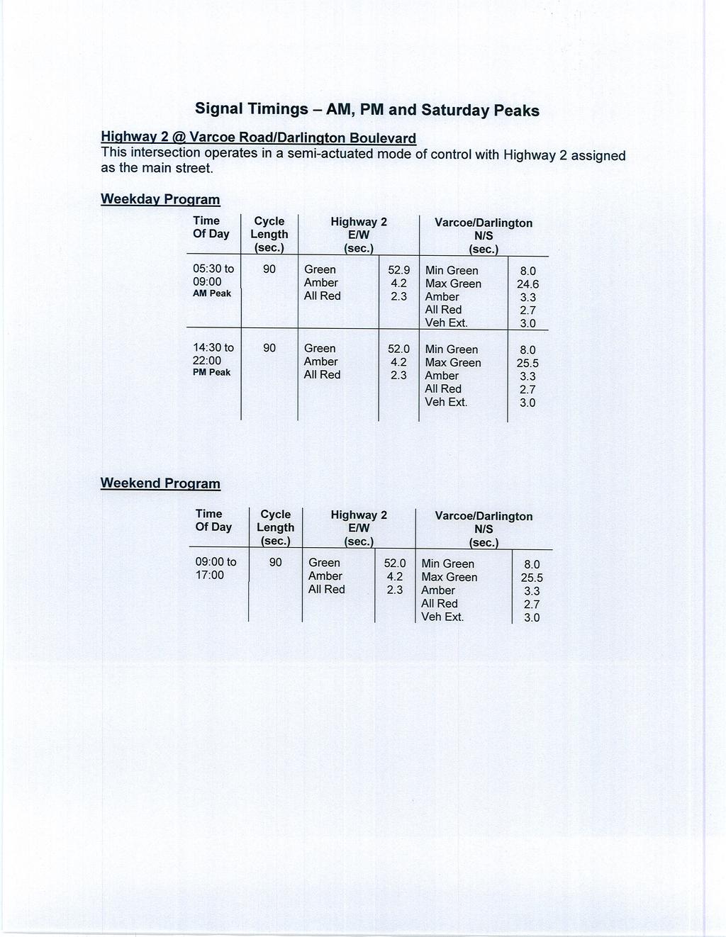
44
45
46 Turning Movement Count Location Name: HWY2 & CENTERFIELD ROAD Date: Wed, Jun 1, 216 Deployment Lead: Theo Daglis NexTrans 4261-A14 Highway 7 East Suite 489 Markham ON, CANADA, L3R 9W6 Turning Movement Count (3. HWY2 & CENTERFIELD ROAD) Start Time Right N:W N Approach CENTERFIELD ROAD Left N:E Peds N: Approach Total Right E:N Thru E:W E Approach HWY2 Peds E: Approach Total Thru W:E Left W:N W Approach HWY2 Peds W: Approach Total Int. Total (15 min) Int. Total (1 hr) 7:: :15: :3: :45: :: :15: :3: :45: :: :15: :3: :45: ***BREAK*** 16:: :15: :3: :45: :: :15: :3: :45: :: :15: :3: Turning Movement Count Page 1 of 6 NXT16T8V
47 Turning Movement Count Location Name: HWY2 & CENTERFIELD ROAD Date: Wed, Jun 1, 216 Deployment Lead: Theo Daglis NexTrans 4261-A14 Highway 7 East Suite 489 Markham ON, CANADA, L3R 9W6 18:45: Grand Total Approach% 58.6% 41.4% % 88.3% - 9.2% 9.8% Totals % 5.7% 4.1% 9.8% 5.3% 39.8% 45.1% 4.7% 4.4% 45.1% - - Heavy Heavy %.9% 1% - 1% 1.5% - 1.8% 1.2% Bicycles Bicycle % % % - % % - % % Turning Movement Count Page 2 of 6 NXT16T8V
48 Turning Movement Count Location Name: HWY2 & CENTERFIELD ROAD Date: Wed, Jun 1, 216 Deployment Lead: Theo Daglis NexTrans 4261-A14 Highway 7 East Suite 489 Markham ON, CANADA, L3R 9W6 Peak Hour: 7:3 AM - 8:3 AM Weather: Start Time N Approach CENTERFIELD ROAD E Approach HWY2 W Approach HWY2 Right Left Peds Approach Total Right Thru Peds Approach Total Thru Left Peds Approach Total Int. Total (15 min) 7:3: :45: :: :15: Grand Total Approach% 62.4% 37.6% % 87.2% - 91% 9% - - Totals % 8.1% 4.9% 12.9% 7.5% 51.6% 59.2% 25.4% 2.5% 27.9% - PHF Heavy Heavy %.5%.8%.6%.5% 2.4% 2.2% 3.9% 3.3% 3.8% - Lights Lights % 99.5% 99.2% 99.4% 99.5% 97.6% 97.8% 96.1% 96.7% 96.2% - Single-Unit Trucks Single-Unit Trucks %.5% %.3% %.8%.7% 2.3% % 2.1% - Buses Buses % %.8%.3%.5% 1.4% 1.3% 1.5% 3.3% 1.6% - Articulated Trucks Articulated Trucks % % % % %.2%.1%.2% %.1% - Pedestrians Pedestrians% - - 5% - - % - - 5% - Bicycles on Crosswalk Bicycles on Crosswalk% - - % - - % - - % - Bicycles on Road Bicycles on Road% - - % - - % - - % - Turning Movement Count Page 3 of 6 NXT16T8V
49 Turning Movement Count Location Name: HWY2 & CENTERFIELD ROAD Date: Wed, Jun 1, 216 Deployment Lead: Theo Daglis NexTrans 4261-A14 Highway 7 East Suite 489 Markham ON, CANADA, L3R 9W6 Peak Hour: 4:15 PM - 5:15 PM Weather: Start Time N Approach CENTERFIELD ROAD E Approach HWY2 W Approach HWY2 Right Left Peds Approach Total Right Thru Peds Approach Total Thru Left Peds Approach Total Int. Total (15 min) 16:15: :3: :45: :: Grand Total Approach% 51.6% 48.4% - 9% 91% - 9.4% 9.6% - - Totals % 3.6% 3.4% 7.1% 3.3% 33.1% 36.4% 51.1% 5.4% 56.5% - PHF Heavy Heavy % 2.7%.9% 1.8% %.8%.7% 1% 1.2% 1% - Lights Lights % 97.3% 99.1% 98.2% 1% 99.2% 99.3% 99% 98.8% 99% - Single-Unit Trucks Single-Unit Trucks % 2.7% % 1.4% %.1%.1%.7% 1.2%.7% - Buses Buses % %.9%.5% %.7%.6%.3% %.3% - Articulated Trucks - Articulated Trucks % % % % % % % % % % - Pedestrians Pedestrians% % - - % % - Bicycles on Crosswalk Bicycles on Crosswalk% % - - % % - Bicycles on Road Bicycles on Road% - - % - - % - - % - Turning Movement Count Page 4 of 6 NXT16T8V
50 1 Turning Movement Count Location Name: HWY2 & CENTERFIELD ROAD Date: Wed, Jun 1, 216 Deployment Lead: Theo Daglis NexTrans 4261-A14 Highway 7 East Suite 489 Markham ON, CANADA, L3R 9W6 Peak Hour: 7:3 AM - 8:3 AM Weather: Legend: ### (#.# %) TOTAL VEHICLES (HEAVY %) 244 N 314 (.8%) 118 (.5%) (.5%) 1252 (2.4%) 1435 E W 676 (3.3%) 61 (3.9%) 615 Bicycles on Crosswalk Pedestrians N 1 E W 1 Turning Movement Count Page 5 of 6 NXT16T8V
 TOTAL VEHICLES (HEAVY %) 27 N 219 (.9%) 16 (2.7%) 113 9 12 (.%) 128 (.8%) 113 E 1692 1141 W 1754 (1.2%) 168 (1.")
51 5 Turning Movement Count Location Name: HWY2 & CENTERFIELD ROAD Date: Wed, Jun 1, 216 Deployment Lead: Theo Daglis NexTrans 4261-A14 Highway 7 East Suite 489 Markham ON, CANADA, L3R 9W6 Peak Hour: 4:15 PM - 5:15 PM Weather: Legend: ### (#.# %) TOTAL VEHICLES (HEAVY %) 27 N 219 (.9%) 16 (2.7%) (.%) 128 (.8%) 113 E W 1754 (1.2%) 168 (1.%) 1586 Bicycles on Crosswalk Pedestrians N 3 6 E W 1 4 Turning Movement Count Page 6 of 6 NXT16T8V
52 Turning Movement Count Location Name: HWY2 & DARLINGTON BOULEVARD Date: Wed, Jun 1, 216 Deployment Lead: Theo Daglis NexTrans 4261-A14 Highway 7 East Suite 489 Markham ON, CANADA, L3R 9W6 Turning Movement Count (1. HWY2 & DARLINGTON BOULEVARD) Start Time Right N:W Thru N:S N Approach VARCOE RD Left N:E Peds N: Approach Total Right E:N Thru E:W E Approach HWY2 Left E:S Peds E: Approach Total Right S:E Thru S:N S Approach DARLINGTON BOULEVARD Left S:W Peds S: Approach Total Right W:S Thru W:E W Approach HWY2 Left W:N Peds W: Approach Total Int. Total (15 min) Int. Total (1 hr) 7:: :15: :3: :45: :: :15: :3: :45: :: :15: :3: :45: ***BREAK*** 16:: :15: :3: :45: :: :15: :3: :45: :: :15: :3: :45: Grand Total Approach% 42.5% 18.1% 39.4% - 3.4% 89.9% 6.8% % 23% 44.3% - 4.7% 88% 7.4% Totals % 4.2% 1.8% 3.9% 9.9% 1.5% 39% 2.9% 43.4% 2% 1.4% 2.7% 6.1% 1.9% 35.7% 3% 4.5% - - Heavy Heavy % 1.8% 1.7% 3% - 2.5% 1.3% 1.7% - 1.8% 2.2% 1.1% - 1.6% 1.6% 1.5% Bicycles Bicycle % %.7% % - % % % - % 1.3% % - % % % Turning Movement Count Page 1 of 6 NXT16T8V
53 Turning Movement Count Location Name: HWY2 & DARLINGTON BOULEVARD Date: Wed, Jun 1, 216 Deployment Lead: Theo Daglis NexTrans 4261-A14 Highway 7 East Suite 489 Markham ON, CANADA, L3R 9W6 Turning Movement Count Page 2 of 6 NXT16T8V
54 Turning Movement Count Location Name: HWY2 & DARLINGTON BOULEVARD Date: Wed, Jun 1, 216 Deployment Lead: Theo Daglis NexTrans 4261-A14 Highway 7 East Suite 489 Markham ON, CANADA, L3R 9W6 Peak Hour: 7:3 AM - 8:3 AM Weather: Start Time N Approach VARCOE RD E Approach HWY2 S Approach DARLINGTON BOULEVARD W Approach HWY2 Right Thru Left Peds Approach Total Right Thru Left Peds Approach Total Right Thru Left Peds Approach Total Right Thru Left Peds Approach Total Int. Total (15 min) 7:3: :45: :: :15: Grand Total Approach% 65.3% 12.5% 22.2% - 2.8% 91.6% 5.6% % 15.5% 6% - 4.1% 9.2% 5.8% - - Totals % 5.9% 1.1% 2% 9% 1.7% 54.7% 3.4% 59.7% 1.1%.7% 2.7% 4.6% 1.1% 24.1% 1.5% 26.7% - PHF Heavy Heavy % 1.4% 3.7% 14.6% 4.6% 7.5% 1.8% 3.7% 2.1% 11.1% 5.9% 3% 5.5% % 2.9% 5.4% 3% - Lights Lights % 98.6% 96.3% 85.4% 95.4% 92.5% 98.2% 96.3% 97.9% 88.9% 94.1% 97% 94.5% 1% 97.1% 94.6% 97% - Single-Unit Trucks Single-Unit Trucks %.7% % 2.1%.9% 2.5%.7% 1.2%.8% 3.7% % 3% 2.7% % 1.9% % 1.7% - Buses Buses %.7% 3.7% 12.5% 3.7% 5%.9% 2.5% 1.1% 7.4% 5.9% % 2.7% %.9% %.8% - Articulated Trucks Articulated Trucks % % % % % %.2% %.2% % % % % %.2% 5.4%.5% - Pedestrians Pedestrians% % % % % - Bicycles on Crosswalk Bicycles on Crosswalk% % % % % - Bicycles on Road Bicycles on Road% % % % % - Turning Movement Count Page 3 of 6 NXT16T8V
55 Turning Movement Count Location Name: HWY2 & DARLINGTON BOULEVARD Date: Wed, Jun 1, 216 Deployment Lead: Theo Daglis NexTrans 4261-A14 Highway 7 East Suite 489 Markham ON, CANADA, L3R 9W6 Peak Hour: 5: PM - 6: PM Weather: Start Time N Approach VARCOE RD E Approach HWY2 S Approach DARLINGTON BOULEVARD W Approach HWY2 Right Thru Left Peds Approach Total Right Thru Left Peds Approach Total Right Thru Left Peds Approach Total Right Thru Left Peds Approach Total Int. Total (15 min) 17:: :15: :3: :45: Grand Total Approach% 32.3% 2.2% 47.5% - 4.2% 87.5% 8.3% - 39% 24.5% 36.5% - 4.6% 87.3% 8.1% - - Totals % 3.3% 2.1% 4.8% 1.2% 1.4% 29.6% 2.8% 33.8% 2.8% 1.8% 2.6% 7.2% 2.3% 42.7% 3.9% 48.9% - PHF Heavy Heavy % 1.8% 1.4% 2.5% 2.1% %.9% %.8% % % % % 1.3% 1.1% % 1% - Lights Lights % 98.2% 98.6% 97.5% 97.9% 1% 99.1% 1% 99.2% 1% 1% 1% 1% 98.7% 98.9% 1% 99% - Single-Unit Trucks Single-Unit Trucks %.9% 1.4%.6%.9% %.3% %.3% % % % % 1.3%.6% %.5% - Buses Buses %.9% % 1.9% 1.2% %.6% %.5% % % % % %.5% %.4% - Articulated Trucks Articulated Trucks % % % % % % % % % % % % % %.1% %.1% - Pedestrians Pedestrians% % % % % - Bicycles on Crosswalk Bicycles on Crosswalk% % % % % - Bicycles on Road Bicycles on Road% % % % % - Turning Movement Count Page 4 of 6 NXT16T8V
56 94 N 216 (14.6%) 48 ( 3.7%) 27 ( 1.4%) (11.1%) 17 (5.9% ) 66 (3.% ) 3 Turning Movement Count Location Name: HWY2 & DARLINGTON BOULEVARD Date: Wed, Jun 1, 216 Deployment Lead: Theo Daglis NexTrans 4261-A14 Highway 7 East Suite 489 Markham ON, CANADA, L3R 9W6 Peak Hour: 7:3 AM - 8:3 AM Weather: Legend: ### (#.# %) TOTAL VEHICLES (HEAVY %) 152 W 641 (5.4%) 37 (2.9%) 578 (.%) (7.5%) 1313 (1.8%) 81 (3.7%) 1434 E S 134 Bicycles on Crosswalk Pedestrians N 2 2 S 2 2 E 3 W 1 5 Turning Movement Count Page 5 of 6 NXT16T8V
 Turning Movement Count Location Name: HWY2 & DARLINGTON BOULEVARD Date: Wed, Jun 1, 216 Deployment Lead: Theo Daglis NexTrans 4261-A14 Highway 7 East Suite 489 Markham ON, CANADA, L3R 9W6 Peak")
57 238 N 341 (2.5%) 162 (1.4%) 69 (1.8%) (.%) 59 (.%) 88 (.%) Turning Movement Count Location Name: HWY2 & DARLINGTON BOULEVARD Date: Wed, Jun 1, 216 Deployment Lead: Theo Daglis NexTrans 4261-A14 Highway 7 East Suite 489 Markham ON, CANADA, L3R 9W6 Peak Hour: 5: PM - 6: PM Weather: Legend: ### (#.# %) TOTAL VEHICLES (HEAVY %) 1189 W 1638 (.%) 132 (1.1%) 143 (1.3%) (.%) 991 (.9%) 94 (.%) 1132 E S 239 Bicycles on Crosswalk Pedestrians N 3 8 S 3 7 E W 2 17 Turning Movement Count Page 6 of 6 NXT16T8V
58 Turning Movement Count Location Name: HWY2 & OLD KINGSTON ROAD Date: Wed, Jun 1, 216 Deployment Lead: Theo Daglis NexTrans 4261-A14 Highway 7 East Suite 489 Markham ON, CANADA, L3R 9W6 Turning Movement Count (2. HWY2 & OLD KINGSTON ROAD) Start Time Thru E:W Left E:S E Approach HWY2 Peds E: Approach Total Right S:E S Approach OLD KINGSTON ROAD Left S:W Peds S: Approach Total Right W:S Thru W:E W Approach HWY2 Peds W: Approach Total Int. Total (15 min) Int. Total (1 hr) 7:: :15: :3: :45: :: :15: :3: :45: :: :15: :3: :45: ***BREAK*** 16:: :15: :3: :45: :: :15: :3: :45: :: :15: :3: Turning Movement Count Page 1 of 6 NXT16T8V
59 Turning Movement Count Location Name: HWY2 & OLD KINGSTON ROAD Date: Wed, Jun 1, 216 Deployment Lead: Theo Daglis NexTrans 4261-A14 Highway 7 East Suite 489 Markham ON, CANADA, L3R 9W6 18:45: Grand Total Approach% 99.9%.1% % 53.8% - % 1% Totals % 5.3% % 5.4% % %.1% % 49.5% 49.5% - - Heavy Heavy % 1.4% 2% - 5% % - % 1.7% Bicycles Bicycle % % % - % % % % Turning Movement Count Page 2 of 6 NXT16T8V
60 Turning Movement Count Location Name: HWY2 & OLD KINGSTON ROAD Date: Wed, Jun 1, 216 Deployment Lead: Theo Daglis NexTrans 4261-A14 Highway 7 East Suite 489 Markham ON, CANADA, L3R 9W6 Peak Hour: 7:3 AM - 8:3 AM Weather: Start Time E Approach HWY2 S Approach OLD KINGSTON ROAD W Approach HWY2 Thru Left Peds Approach Total Right Left Peds Approach Total Right Thru Peds Approach Total Int. Total (15 min) 7:3: :45: :: :15: Grand Total Approach% 1% % - % % - % 1% - - Totals % 68.2% % 68.2% % % % % 31.8% 31.8% - PHF Heavy Heavy % 2.2% % 2.2% % % % % 4% 4% - Lights Lights % 97.8% % 97.8% % % % % 96% 96% - Single-Unit Trucks Single-Unit Trucks %.8% %.8% % % % % 1.9% 1.9% - Buses Buses % 1.2% % 1.2% % % % % 1.9% 1.9% - Articulated Trucks Articulated Trucks %.2% %.2% % % % %.1%.1% - Pedestrians Pedestrians% - - % - - 1% - - % - Bicycles on Crosswalk Bicycles on Crosswalk% - - % - - % - - % - Bicycles on Road Bicycles on Road% - - % - - % - - % - Turning Movement Count Page 3 of 6 NXT16T8V
61 Turning Movement Count Location Name: HWY2 & OLD KINGSTON ROAD Date: Wed, Jun 1, 216 Deployment Lead: Theo Daglis NexTrans 4261-A14 Highway 7 East Suite 489 Markham ON, CANADA, L3R 9W6 Peak Hour: 5: PM - 6: PM Weather: Start Time E Approach HWY2 S Approach OLD KINGSTON ROAD W Approach HWY2 Thru Left Peds Approach Total Right Left Peds Approach Total Right Thru Peds Approach Total Int. Total (15 min) 17:: :15: :3: :45: Grand Total Approach% 99.9% % - % 1% - % 1% - - Totals % 39.3% % 39.3% % % % % 6.6% 6.6% - PHF Heavy Heavy %.9% %.9% % % % % 1.1% 1.1% - Lights Lights % 99.1% % 99.1% % 1% 1% % 98.9% 98.9% - Single-Unit Trucks Single-Unit Trucks %.4% %.4% % % % %.6%.6% - Buses Buses %.5% %.5% % % % %.5%.5% - Articulated Trucks Articulated Trucks % % % % % % % %.1%.1% - Pedestrians Pedestrians% - - % % - - % - Bicycles on Crosswalk Bicycles on Crosswalk% - - % % - - % - Bicycles on Road Bicycles on Road% - - % - - % - - % - Turning Movement Count Page 4 of 6 NXT16T8V
62 Turning Movement Count Location Name: HWY2 & OLD KINGSTON ROAD Date: Wed, Jun 1, 216 Deployment Lead: Theo Daglis NexTrans 4261-A14 Highway 7 East Suite 489 Markham ON, CANADA, L3R 9W6 Peak Hour: 7:3 AM - 8:3 AM Weather: Legend: ### (#.# %) TOTAL VEHICLES (HEAVY %) 1449 W 676 (4.%) 676 (.%) (2.2%) (.%) 1449 E 676 (.%) (.%) S Bicycles on Crosswalk Pedestrians S 3 E W Turning Movement Count Page 5 of 6 NXT16T8V
 TOTAL VEHICLES (HEAVY %) 1133 (.9%) (.%) 1133 E 1749 1134 W 1749 (1.1%) 1749 (.%) 12 (.%) 1 (.")
63 Turning Movement Count Location Name: HWY2 & OLD KINGSTON ROAD Date: Wed, Jun 1, 216 Deployment Lead: Theo Daglis NexTrans 4261-A14 Highway 7 East Suite 489 Markham ON, CANADA, L3R 9W6 Peak Hour: 5: PM - 6: PM Weather: Legend: ### (#.# %) TOTAL VEHICLES (HEAVY %) 1133 (.9%) (.%) 1133 E W 1749 (1.1%) 1749 (.%) 12 (.%) 1 (.%) 1 S Bicycles on Crosswalk Pedestrians S 7 5 E W Turning Movement Count Page 6 of 6 NXT16T8V
9 Leeming Drive Redevelopment Ottawa, ON Transportation Brief. Prepared By: Stantec Consulting Ltd.
 9 Leeming Drive Redevelopment Ottawa, ON Transportation Brief Prepared By: Stantec Consulting Ltd. TIA GUIDELINES CHECKLIST Report Context Municipal Address Comment: Section 1.1 Location relative to major
South Albion-Bolton Community Plan North Hill Supermarket Transportation Study Part B: Evaluation of Alternatives
 Community Plan North Hill Supermarket Transportation Study Part B: Evaluation of Alternatives Prepared for: The Town of Caledon August 9 Transportation Solutions Ltd. 43 Forest Road Cambridge, ON N1S 3B4
5858 N COLLEGE, LLC N College Avenue Traffic Impact Study
 5858 N COLLEGE, LLC nue Traffic Impact Study August 22, 2016 Contents Traffic Impact Study Page Preparer Qualifications... 1 Introduction... 2 Existing Roadway Conditions... 5 Existing Traffic Conditions...
Traffic Impact Study. Westlake Elementary School Westlake, Ohio. TMS Engineers, Inc. June 5, 2017
 TMS Engineers, Inc. Traffic Impact Study Westlake Elementary School Westlake, Ohio June 5, 2017 Prepared for: Westlake City Schools - Board of Education 27200 Hilliard Boulevard Westlake, OH 44145 TRAFFIC
OFFICE/RETAIL DEVELOPMENT 1625 BANK STREET OTTAWA, ONTARIO TRANSPORTATION BRIEF. Prepared for: Canada Inc.
 OFFICE/RETAIL DEVELOPMENT 1625 BANK STREET OTTAWA, ONTARIO TRANSPORTATION BRIEF Prepared for: 9402209 Canada Inc. December 15, 2015 115-625 Report_2.doc D. J. Halpenny & Associates Ltd. Consulting Transportation
Transportation Impact Study for Abington Terrace
 Transportation Impact Study for Abington Terrace Abington Township, Montgomery County, PA Sandy A. Koza, P.E., PTOE PA PE License Number PE059911 Prepared by McMahon Associates, Inc. 425 Commerce Drive,
HENDERSON DEVELOPMENT 213, 217, 221, 221 ½, 223 HENDERSON AVENUE and 65 TEMPLETON STREET OTTAWA, ONTARIO TRANSPORTATION OVERVIEW.
 HENDERSON DEVELOPMENT 213, 217, 221, 221 ½, 223 HENDERSON AVENUE and 65 TEMPLETON STREET OTTAWA, ONTARIO TRANSPORTATION OVERVIEW Prepared for: 2294170 Ontario Inc. February 2, 2017 117-652 Report_1.doc
VIVA RETIREMENT COMMUNITIES OAKVILLE TRAFFIC IMPACT STUDY
 VIVA RETIREMENT COMMUNITIES OAKVILLE TRAFFIC IMPACT STUDY VIVA RETIREMENT COMMUNITIES OAKVILLE TRAFFIC IMPACT STUDY DECEMBER 2012 READ, VOORHEES & ASSOCIATES TORONTO, ONTARIO Read, Voorhees & Associates
TRAFFIC STUDY GUIDELINES Clarksville Street Department
 TRAFFIC STUDY GUIDELINES Clarksville Street Department 9/1/2009 Introduction Traffic studies are used to help the city determine potential impacts to the operation of the surrounding roadway network. Two
4.0 TRAFFIC IMPACT STUDIES
 SECTION 4 4.0 TRAFFIC IMPACT STUDIES 4.1 TRAFFIC IMPACT STUDY REQUIREMENTS The City has established Traffic Impact Study (TIS) requirements for the purpose of ensuring that both the quantitative and qualitative
Magnolia Place. Traffic Impact Analysis. Prepared for: City of San Mateo. Prepared by: Hexagon Transportation Consultants, Inc.
 Magnolia Place Traffic Impact Analysis Prepared for: City of San Mateo Prepared by: Hexagon Transportation Consultants, Inc. Updated January 4, 2010 Table of Contents 1. Introduction...1 2. Existing Conditions...6
NEW YORK CENTRAL PARK SUBDIVISION BLAIS STREET/ST-PIERRE STREET EMBRUN, ONTARIO TRAFFIC IMPACT STUDY. Prepared for:
 NEW YORK CENTRAL PARK SUBDIVISION BLAIS STREET/ST-PIERRE STREET EMBRUN, ONTARIO TRAFFIC IMPACT STUDY Prepared for: Solidex Holdings Limited & Investissement Maurice Lemieux Investments Attn: Mr. Anthony
MEDICAL/OFFICE BUILDING 1637 BANK STREET OTTAWA, ONTARIO TRANSPORTATION OVERVIEW. Prepared for:
 MEDICAL/OFFICE BUILDING 1637 BANK STREET OTTAWA, ONTARIO TRANSPORTATION OVERVIEW Prepared for: 2434984 Ontario Inc. 13-5510 Canotek Road Ottawa, Ontario K1J 9J5 June 4, 2015 115-613 Report_2.doc D. J.
TRAFFIC IMPACT STUDY CRITERIA
 Chapter 6 - TRAFFIC IMPACT STUDY CRITERIA 6.1 GENERAL PROVISIONS 6.1.1. Purpose: The purpose of this document is to outline a standard format for preparing a traffic impact study in the City of Steamboat
Technical Memorandum TRAFFIC IMPACT STUDY. RIDLEY ROAD CONVENIENCE STORE Southampton County, VA. Prepared for: Mr. David Williams.
 Technical Memorandum TRFFIC IMPCT STUDY RIDLEY ROD CONVENIENCE STORE Southampton County, V Prepared for: Mr. David Williams By: Charles Smith, P.E., PTOE EPR Charlottesville, V July 2014 1 TBLE OF CONTENTS
Prepared For: Shieldbay Developments Inc. c/o Matson, McConnell Ltd. 2430A Bloor Street West Toronto, Ontario M6S 1P9.
 Prepared For: Shieldbay Developments Inc. c/o Matson, McConnell Ltd. 2430A Bloor Street West Toronto, Ontario M6S 1P9 Prepared By: URS Canada Inc. 4 th Floor, 30 Leek Crescent Richmond Hill, Ontario L4B
INDUSTRIAL BUILDING 3009 HAWTHORNE ROAD CITY OF OTTAWA TRANSPORTATION OVERVIEW REVISED. Prepared for: Canada Inc.
 INDUSTRIAL BUILDING 3009 HAWTHORNE ROAD CITY OF OTTAWA TRANSPORTATION OVERVIEW REVISED Prepared for: 7849648 Canada Inc. Octiober 1, 2015 114-598 Overview_2.doc D. J. Halpenny & Associates Ltd. Consulting
TRANSPORTATION ANALYSIS REPORT US Route 6 Huron, Erie County, Ohio
 TRANSPORTATION ANALYSIS REPORT US Route 6 Huron, Erie County, Ohio December 12, 2012 Prepared for: The City of Huron 417 Main Huron, OH 44839 Providing Practical Experience Technical Excellence and Client
APARTMENT BUILDING DEVELOPMENT 1161 HERON ROAD OTTAWA, ONTARIO TRANSPORTATION IMPACT STUDY. Prepared for:
 APARTMENT BUILDING DEVELOPMENT 1161 HERON ROAD OTTAWA, ONTARIO TRANSPORTATION IMPACT STUDY Prepared for: 1649362 Ontario Inc. c/o Manor Park Management 231 Brittany Drive, Suite D Ottawa ON K1K 0R8 July
Henderson Avenue Mixed-Use Development
 Zoning Case: Z145-3 Traffic Impact Analysis Henderson Avenue Mixed-Use Development Dallas, TX October 26 th, 216 Kimley-Horn and Associates, Inc. Dallas, Texas Project #644827 Registered Firm F-928 Traffic
William Jackson Drive & Earl Grey Avenue, Pickering, ON Transportation Study. Trillium Housing Oak Non-Profit Corp.
 William Jackson Drive & Earl Grey Avenue, Pickering, ON Transportation Study Trillium Housing Oak Non-Profit Corp. R.J. Burnside & Associates Limited 1465 Pickering Parkway Suite 2 Pickering ON L1V 7G7
Walmart (Store # ) 60 th Street North and Marion Road Sioux Falls, South Dakota
 60 th Street North and Marion Road Sioux Falls, South Dakota") Walmart (Store #4865-00) 60 th Street North and Marion Road Sioux Falls, South Dakota Prepared for: Wal-Mart Stores, Inc. Bentonville, Arkansas Prepared by: Kimley-Horn and Associates, Inc. ã2013 Kimley-Horn
Walmart (Store #4865-00) 60 th Street North and Marion Road Sioux Falls, South Dakota Prepared for: Wal-Mart Stores, Inc. Bentonville, Arkansas Prepared by: Kimley-Horn and Associates, Inc. ã2013 Kimley-Horn
Appendix C. NORTH METRO STATION AREA TRAFFIC IMPACT STATEMENT 88th Avenue Station
 Appendix C NORTH METRO STATION AREA TRAFFIC IMPACT STATEMENT 88th Avenue Station Prepared for: Regional Transportation Department and URS Corporation as part of the North Metro EIS David Evans and Associates,
Joe Rocca P.Eng., Traffic and Asset Management Supervisor. Review for Proposed Kingsway Sports and Entertainment Complex, City of Greater Sudbury
 LETTER REPORT TO: Joe Rocca P.Eng., Traffic and Asset Management Supervisor FROM: Brett Sears and Ubaid Ali, WSP SUBJECT: Review for Proposed Kingsway Sports and Entertainment Complex, City of Greater
3.2.2 Proposed Road Network within Phase 1B Lands
 3.2.2 Proposed Road Network within Phase 1B Lands Figure 3.1 also shows the proposed road network within the Premier Gateway Phase 1B Employment Area lands, which features two collector roads providing
OTTAWA TRAIN YARDS PHASE 3 DEVELOPMENT CITY OF OTTAWA TRANSPORTATION IMPACT STUDY. Prepared for:
 OTTAWA TRAIN YARDS PHASE 3 DEVELOPMENT CITY OF OTTAWA TRANSPORTATION IMPACT STUDY Prepared for: The Ottawa Train Yards Inc. 223 Colonnade Road South, Suite 212 Nepean, Ontario K2E 7K3 January 17, 2012
Marina Loft (DRC 51-R-12)
") Marina Loft (DRC 51-R-12) traffic study prepared for: Cymbal Development OCtober 2012 Traf Tech October 1, 2012 Mr. Asi Cymbal - President Cymbal Development 3470 North Miami Avenue Upper Suite Miami,
Marina Loft (DRC 51-R-12) traffic study prepared for: Cymbal Development OCtober 2012 Traf Tech October 1, 2012 Mr. Asi Cymbal - President Cymbal Development 3470 North Miami Avenue Upper Suite Miami,
Traffic Impact Analysis Chatham County Grocery Chatham County, NC
 Chatham County Grocery Chatham County, NC TABLE OF CONTENTS 1. INTRODUCTION... 1 1.1. Location and Study Area... 1 1.2. Proposed Land Use and Access... 2 1.3. Adjacent Land Uses... 2 1.4. Existing ways...
The proposed development is located within 800m of an existing Transit Station where infill developments and intensification are encouraged.
 Stantec Consulting Ltd. 1331 Clyde Avenue, Suite 4 Ottawa ON K2C 3G4 Tel: (613) 722-442 Fax: (613) 722-2799 May 14, 213 File: 1638823 Robinson Park Development Corp. 5699 Power Road Ottawa, ON, K1G 3N4
List of Exhibits...ii
 One Brickell Traffic Study TABLE OF CONTENTS List of Exhibits...ii EXECUTIVE SUMMARY...1 1. INTRODUCTION...2 1.1 Study Area...2 1.2 Study Objective...5 2. EXISTING TRAFFIC CONDITIONS...6 2.1 Data Collection...6
TRAFFIC IMPACT STUDY COMPREHENSIVE UPDATE TOWN OF THOMPSON S STATION, TENNESSEE PREPARED FOR: THE TOWN OF THOMPSON S STATION
 TRAFFIC IMPACT STUDY COMPREHENSIVE UPDATE TOWN OF THOMPSON S STATION, TENNESSEE PREPARED FOR: THE TOWN OF THOMPSON S STATION Transportation Consultants, LLC 1101 17 TH AVENUE SOUTH NASHVILLE, TN 37212
Ajax. Ajax Downs. Proposed Ajax Downs Expansion Transportation Assessment Town of Ajax
 Ajax Ajax Downs Proposed Ajax Downs Expansion Transportation Assessment Town of Ajax 2821628 (13281) March 2015 March 19, 2015 Mr Andrew Picov Ajax Downs 50 Alexander s Crossing Ajax ON L1Z 2E6 Dear Mr
WELCOME TO OPEN HOUSE # 1 June 14, 2017
 Langstaff Road Weston Road to Highway 7 Class Environmental Assessment Study WELCOME TO OPEN HOUSE # 1 June 14, 2017 Please sign in and join our mailing list Purpose of Open House #1 & Study Area York
TRANSPORTATION IMPACT STUDY
 Dundas MEP Developments Inc. City of Toronto 219 and 231 Dundas Street East, Proposed Mixed-Use Development TRANSPORTATION IMPACT STUDY 9782/2 April 216 LEA Consulting Ltd. Consulting Engineers & Planners
Bridge Street Corridor Study Report
 Bridge Street Corridor Study Report Prepared for: Prepared by: BRIDGE STREET CORRIDOR STUDY REPORT PREPARED FOR: CITY OF ARROYO GRANDE COMMUNITY DEVELOPMENT DEPARTMENT 300 EAST BRANCH STREET ARROYO GRANDE,
Bistro 6. City of Barrie. Traffic Impact Study for Pratt Hansen Group Inc. Type of Document: Final Report. Project Number: JDE 1748
 City of Barrie Traffic Impact Study for Pratt Hansen Group Inc. Type of Document: Final Report Project Number: JDE 1748 Date Submitted: June 12 th, 2017 06/12/17 John Northcote, P.Eng. Professional License
Welcome. The Brooklin Secondary Plan and Transportation Master Plan are collectively referred to as the Brooklin Study.
 Welcome The Town of Whitby is undertaking a study to prepare a Secondary Plan and Transportation Master Plan to guide and manage growth in the Brooklin area. The Brooklin Secondary Plan and Transportation
QUICKIE C STORE AND GAS BAR 1780 HERON ROAD OTTAWA, ONTARIO TRANSPORTATION BRIEF. Prepared for:
 QUICKIE C STORE AND GAS BAR 1780 HERON ROAD OTTAWA, ONTARIO TRANSPORTATION BRIEF Prepared for: Quickie Convenience Stores Larny Holdings Ltd. c/o PBC Group April 15, 2015 115-615 Report_1.doc D. J. Halpenny
CPC Parking Lot Riverside Drive. Transportation Rationale
 CPC Parking Lot Transportation Rationale Prepared By: NOVATECH Suite 200, 240 Michael Cowpland Drive Ottawa, Ontario K2M 1P6 September 2015 Novatech File: 114093 Ref: R-2015-153 Table of Contents 1.0 INTRODUCTION...
TRAFFIC IMPACT STUDY And A TRAFFIC SIGNAL WARRANT ANALYSIS FOR A SENIOR LIVING AND APARTMENT DEVELOPMENT
 TRAFFIC IMPACT STUDY And A TRAFFIC SIGNAL WARRANT ANALYSIS FOR A SENIOR LIVING AND APARTMENT DEVELOPMENT DEERFIELD TOWNSHIP, WARREN COUNTY, OHIO Nantucket Circle and Montgomery Road () Prepared for: ODLE
Corporate. Report COUNCIL DATE: June 26, 2006 NO: C012 COUNCIL-IN-COMMITTEE. TO: Mayor & Council DATE: June 22, 2006
 Corporate NO: C012 Report COUNCIL DATE: June 26, 2006 COUNCIL-IN-COMMITTEE TO: Mayor & Council DATE: June 22, 2006 FROM: General Manager, Engineering FILE: 0410-20(MoT/Gate) SUBJECT: Surrey Response on
TRAFFIC IMPACT STUDY. Creekside Thornton, Colorado. For. August 2015 November 2015 Revised: August Prepared for:
 TRAFFIC IMPACT STUDY For Creekside Thornton, Colorado August 215 November 215 Revised: August 216 Prepared for: Jansen Strawn Consulting Engineers 45 West 2 nd Avenue Denver, Colorado 8223 Prepared by:
BLUE SEA VILLAGE MER BLEUE 2159 MER BLEUE ROAD OTTAWA, ONTARIO TRANSPORTATION IMPACT ASSESSMENT. Prepared for: Ontario Limited.
 BLUE SEA VILLAGE MER BLEUE 2159 MER BLEUE ROAD OTTAWA, ONTARIO TRANSPORTATION IMPACT ASSESSMENT Prepared for: 2534189 Ontario Limited April 6, 2018 117-668 TIA Report_2.doc D. J. Halpenny & Associates
Traffic Analysis Update: 195 Meandering Brook Drive Development
 1223 Michael Street, Suite 1, Ottawa, Ontario K1J 7T2 P: +1 613.738.416 F: +1 613.739.715 www.parsons.com September 27, 216 Jean-Guy Rivard c/o Valecraft Homes 1455 Youville Drive Suite 21 Ottawa, Ontario
Traffic Impact Analysis Walton Acres at Riverwood Athletic Club Clayton, NC
 Traffic Impact Analysis Walton Acres at Riverwood Athletic Club Clayton, NC 1. TABLE OF CONTENTS INTRODUCTION...1 1.1. Site Location and Study Area...1 1.2. Proposed Land Use and Site Access...2 1.3.
6060 North Central Expressway Mixed-Use Site Dallas, Texas
 Volume 1 Traffic Impact Analysis 6060 North Central Expressway Mixed-Use Site Dallas, Texas April 30, 2018 Kimley-Horn and Associates, Inc. Dallas, Texas Project #063238300 Registered Firm F-928 Traffic
TRAFFIC ASSESSMENT River Edge Colorado
 TRAFFIC ASSESSMENT River Edge Colorado Submitted by: Fehr & Peers 621 17th Street, Ste. 231 Denver, CO 8293 (33) 296-43 December, 21 App. M-2 Traffic Assessment River Edge Colorado December 21 TABLE OF
City of Hamilton s Transportation Master Plan (TMP) Public Consultation 3 December 2015
 Public Consultation 3 December 2015") City of Hamilton s Transportation Master Plan (TMP) Public Consultation 3 December 2015 McPhail Transportation Planning Services Ltd. AGENDA 6:00 7:00 pm Viewing Boards / Q & A with the Team 7:00 7:50
City of Hamilton s Transportation Master Plan (TMP) Public Consultation 3 December 2015 McPhail Transportation Planning Services Ltd. AGENDA 6:00 7:00 pm Viewing Boards / Q & A with the Team 7:00 7:50
THIS PAGE LEFT BLANK INTENTIONALLY
 GA SR 25 Spur at Canal Road Transportation Impact Analysis PREPARED FOR GLYNN COUNTY, GEORGIA 1725 Reynolds Street, Suite 300 Brunswick, Georgia 31520 PREPARED BY 217 Arrowhead Boulevard Suite 26 Jonesboro,
MEETING FACILITY 2901 GIBFORD DRIVE CITY OF OTTAWA TRANSPORTATION BRIEF. Prepared for: Holiday Inn Express 2881 Gibford Drive Ottawa, ON K1V 2L9
 MEETING FACILITY 2901 GIBFORD DRIVE CITY OF OTTAWA TRANSPORTATION BRIEF Prepared for: Holiday Inn Express 2881 Gibford Drive Ottawa, ON K1V 2L9 December 18, 2012 112-566 Brief_1.doc D. J. Halpenny & Associates
19 July 2016 OUR REF:
 19 July 2016 OUR REF: 602263-01000 194168 Ontario Ltd. 320 McRae Street Ottawa, ON K1Z 5R8 Attention: Brian Casagrande Dear Brian: Re: 320 McRae/1976 Scott Redevelopment CTS Addendum #1 This Addendum has
TRAFFIC IMPACT ANALYSIS
 TRAFFIC IMPACT ANALYSIS FOR THE CHAMPAIGN UNIT#4 SCHOOL DISTRICT PROPOSED HIGH SCHOOL (SPALDING PARK SITE) IN THE CITY OF CHAMPAIGN Final Report Champaign Urbana Urbanized Area Transportation Study 6/24/2014
Highway 111 Corridor Study
 Highway 111 Corridor Study June, 2009 LINCOLN CO. HWY 111 CORRIDOR STUDY Draft Study Tea, South Dakota Prepared for City of Tea Sioux Falls Metropolitan Planning Organization Prepared by HDR Engineering,
Harbord Street and Hoskin Avenue Bicycle Lane Upgrades
 STAFF REPORT ACTION REQUIRED and Bicycle Lane Upgrades Date: April 22, 2014 To: From: Wards: Reference Number: Public Works and Infrastructure Committee General Manager, Transportation Services 19 and
CITY OF ALPHARETTA DOWNTOWN MASTER PLAN TRAFFIC EVALUATION
 CITY OF ALPHARETTA DOWNTOWN MASTER PLAN TRAFFIC EVALUATION June 2015 CITY OF ALPHARETTA DOWNTOWN MASTER PLAN TRAFFIC EVALUATION Introduction The Alpharetta Downtown Master Plan was developed in the fall
84-88 Columbia Street West Waterloo, Ontario Transportation Impact Study. Paradigm Transportation Solutions Limited
 84-88 Columbia Street West Waterloo, Ontario Transportation Impact Study Paradigm Transportation Solutions Limited June 217 Project Summary Project Number 15255 June 217 Client Masri O Inc. Architects
2136 And 2148 Trafalgar Road Townhouse Development Traffic Brief. Paradigm Transportation Solutions Limited
 2136 And 2148 Trafalgar Road Townhouse Development Traffic Brief Paradigm Transportation Solutions Limited March 217 March 217 Project: 1627 Diana Vlasic, M.C.I.P., R.P.P Metropolitan Consulting 445 Paletta
Proposed Addition to Pickering Islamic Centre
 TRAFFIC IMPACT STUDY, PARKING STUDY, SITE CIRCULATION REVIEW & TDM PLAN Proposed Addition to Pickering Islamic Centre 265 Brock Road City of Pickering, Ontario Prepared for: Pickering Islamic Centre Masjid
1609 E. FRANKLIN STREET HOTEL TRAFFIC IMPACT STUDY EXECUTIVE SUMMARY
 1609 E. FRANKLIN STREET HOTEL TRAFFIC IMPACT STUDY EXECUTIVE SUMMARY Prepared for: The Town of Chapel Hill Public Works Department Traffic Engineering Division Prepared by: HNTB North Carolina, PC 343
AMEC Earth and Environmental. Bovaird Drive Environmental Assessment. Traffic Study Final Report. August Excellence in Transportation Planning
 AMEC Earth and Environmental Bovaird Drive Environmental Assessment Traffic Study Final Report August Excellence in Transportation Planning AMEC Earth and Environmental Bovaird Drive Class EA Traffic
D.13 Transportation and Traffic
 This section addresses transportation and traffic issues and impacts related to the Proposed Project. Section D.13.1 provides a description of the affected environment for the Proposed Project. Applicable
Traffic Impact Study WestBranch Residential Development Davidson, NC March 2016
 Traffic Impact Study WestBranch Residential Development Davidson, NC March 216 TRAFFIC IMPACT STUDY FOR THE WestBranch Residential Development LOCATED IN DAVIDSON, NC Prepared For: Lennar Carolinas, LLC
Classification Criteria
 SCHEDULE D TO RECOMMENDED OFFICIAL PLAN AMENDMENT NO. 40 SCHEDULE C-4 Road Criteria Criteria Traffic Service Objective Land Service/Access Typical Daily Traffic Volume Flow characteristics Travel Speed
Fieldgate. Traffic Impact Study Proposed Retail Commercial and Residential Development Thompson Road and Louis St. Laurent Avenue Town of Milton
 Fieldgate Traffic Impact Study Proposed Retail Commercial and Residential Development Thompson Road and Louis St. Laurent Avenue Town of Milton September 214 September 23 214 Ms Debbie Pacchiarotti Our
APPENDIX 2 LAKESHORE ROAD TRANSPORTATION REVIEW STUDY EXECUTIVE SUMMARY
 APPENDIX 2 LAKESHORE ROAD TRANSPORTATION REVIEW STUDY EXECUTIVE SUMMARY Appendix 2 City of Mississauga Lakeshore Road FINAL REPORT Transportation Review Study December 2010 EXECUTIVE SUMMARY Study Purpose
7 June 2018 OUR REF:
 7 June 2018 OUR REF: 476729-01000 Mirtillo Estates Inc. 1681 Langstaff Road, Unit 1 Vaughan, Ontario, L4K 5T3 Attention: Joran Weiner Vice-President Dear Mr. Weiner: Re: Mirtillo Estates Sales Office Transportation
EXECUTIVE SUMMARY OF CALEDON TRANSPORTATION NEEDS STUDY
 EXECUTIVE SUMMARY OF CALEDON TRANSPORTATION NEEDS STUDY The Caledon Transportation Needs Study has been undertaken as a joint project by the Town of Caledon and the Region of Peel to determine the existing
Sixth Line Development - Transit Facilities Plan
 Memorandum Date: November 13, 2012 To: From: c.c. Subject: Rob Freeman (Freeman Planning) Kevin Phillips Sixth Line Development - Transit Facilities Plan 33016631 This memo was prepared to review the transit
Place Vanier 250 Montreal Road Transportation Impact Study Addendum. Prepared for Broccolini Construction September 20 th, 2012
 Update for the May 31 st, 2012 Traffic Impact Study Prepared for Broccolini Construction 111-23596-00 September 20 th, 2012 2611 Queensview Drive, Suite 300, Ottawa, Ontario CANADA K2B 8K2 Telephone: 613-829-2800
December 15, City of Ottawa Planning and Growth Management Branch 110 Laurier Ave. W., 4 th Floor Ottawa, ON K1P 1J1
 December 15, 2017 City of Ottawa Planning and Growth Management Branch 110 Laurier Ave. W., 4 th Floor Ottawa, ON K1P 1J1 Attention: Mr. Wally Dubyk, C.E.T. Project Manager, Infrastructure Approvals Dear
2.0 LANE WIDTHS GUIDELINE
 2.0 LANE WIDTHS GUIDELINE Road Engineering Design Guidelines Version 2.0.1 May 2018 City of Toronto, Transportation Services City of Toronto Page 0 Background In early 2014, Transportation Services initiated
METHODOLOGY. Signalized Intersection Average Control Delay (sec/veh)
") Chapter 5 Traffic Analysis 5.1 SUMMARY US /West 6 th Street assumes a unique role in the Lawrence Douglas County transportation system. This principal arterial street currently conveys commuter traffic
Chapter 5 Traffic Analysis 5.1 SUMMARY US /West 6 th Street assumes a unique role in the Lawrence Douglas County transportation system. This principal arterial street currently conveys commuter traffic
TABLE OF CONTENTS TABLE OF CONTENTS... I APPENDICES... III LIST OF EXHIBITS... V LIST OF TABLES... VII LIST OF ABBREVIATED TERMS...
 TABLE OF CONTENTS TABLE OF CONTENTS... I APPENDICES... III LIST OF EXHIBITS... V LIST OF TABLES... VII LIST OF ABBREVIATED TERMS... IX 1 INTRODUCTION... 1 1.1 Project Overview... 1 1.2 Analysis Scenarios...
Glenn Avenue Corridor Traffic Operational Evaluation
 Glenn Avenue Corridor Traffic Operational Evaluation PREPARED FOR: THE CITY OF AUBURN PREPARED BY: DECEMBER 2007 Glenn Avenue Corridor Study--Auburn, Alabama TABLE OF CONTENTS Introduction... 1 Background
CastleGlenn Consultants Inc.
 February 1 st, 2010 CastleGlenn Consultants Inc. Engineers, Project Managers & Planners Mr. Kevin Yemm Planning and Land Development Richraft Ltd. 2280 St. Laurent Boulevard Suite 201 Ottawa, Ontario (Tel:
King Soopers #116 Thornton, Colorado
 Traffic Impact Study King Soopers #116 Thornton, Colorado Prepared for: Galloway & Company, Inc. 1.0 EXECUTIVE SUMMARY King Soopers #116, a grocery marketplace anchored commercial development, is proposed
COMMERCIAL DEVELOPMENT 2015 ROBERTSON ROAD OTTAWA, ONTARIO TRANSPORTATION BRIEF. Prepared for:
 COMMERCIAL DEVELOPMENT 2015 ROBERTSON ROAD OTTAWA, ONTARIO TRANSPORTATION BRIEF Prepared for: First Bay Properties Inc. 311 Richmond Road, Suite 203 Ottawa, ON K1Z 6X3 August 8, 2017 117-663 Brief_1.doc
4 DISRUPTION MANAGEMENT PLAN HIGHWAY 7 RAPIDWAY CONSTRUCTION BETWEEN BAYVIEW AVENUE AND WARDEN AVENUE TOWNS OF MARKHAM AND RICHMOND HILL
 4 DISRUPTION MANAGEMENT PLAN HIGHWAY 7 RAPIDWAY CONSTRUCTION BETWEEN BAYVIEW AVENUE AND WARDEN AVENUE TOWNS OF MARKHAM AND RICHMOND HILL The Transportation Services Committee recommends the adoption of
Preliminary Transportation Analysis
 Preliminary Transportation Analysis Goals of a Robust, Multimodal Transportation Network Safe Accessible/Connected Efficient Comfortable Context-Sensitive Motor Vehicle: Continue to analyze the data to
FAIRFIELD INN & SUITES HOTEL 135 THAD JOHNSON PRIVATE OTTAWA TRANSPORTATION BRIEF. Prepared for:
 FAIRFIELD INN & SUITES HOTEL 135 THAD JOHNSON PRIVATE OTTAWA TRANSPORTATION BRIEF Prepared for: Bona Building & Management Co. Ltd. Place Vanier, 333 North River Road Vanier, Ontario K1L 8B9 August 12,
Appendix B Transportation Report
 Project File Report Appendix B Transportation Report Town of Whitby HMM Project No. 327878 Final Report October 2014 Revision and Version Tracking CP Rail Crossing at New Coronation Road Class EA Study
CHAPTER 4 TRANSPORTATION IMPACT STUDY TABLE OF CONTENTS
 CHAPTER 4 TRANSPORTATION IMPACT STUDY TABLE OF CONTENTS Section Title Page 4.1 Introduction... 4-1 4.1.1 General... 4-1 4.1.2 Applicant Responsibility... 4-1 4.1.3 Capacity and Safety Issues... 4-1 A.
Transportation Impact Study Guidelines AS ADOPTED BY REGION OF WATERLOO COUNCIL SEPTEMBER 18, 2013 REPORT NO. P
 Transportation Impact Study Guidelines AS ADOPTED BY REGION OF WATERLOO COUNCIL SEPTEMBER 18, 2013 REPORT NO. P-13-088 HOUSEKEEPING EDITS APPLIED UPDATED TO FILE VERSION 4, JULY 22, 2014 TABLE OF CONTENTS
Shockoe Bottom Preliminary Traffic and Parking Analysis
 Shockoe Bottom Preliminary Traffic and Parking Analysis Richmond, Virginia August 14, 2013 Prepared For City of Richmond Department of Public Works Prepared By 1001 Boulders Pkwy Suite 300, Richmond, VA
APPENDIX G: INTERSECTION NEEDS AT OKEECHOBEE BOULEVARD
 APPENDIX G: INTERSECTION NEEDS AT OKEECHOBEE BOULEVARD INTERSECTION NEEDS AT SR 7 and OKEECHOBEE BOULEVARD SR 7 Extension Project Development and Environment (PD&E) Study From Okeechobee Boulevard (SR
HOLIDAY INN HOTEL 235 KING EDWARD AVENUE CITY OF OTTAWA TRANSPORTATION BRIEF. Prepared for:
 HOLIDAY INN HOTEL 235 KING EDWARD AVENUE CITY OF OTTAWA TRANSPORTATION BRIEF Prepared for: Momentum Planning & Communications 1165 Greenlawn Crescent Ottawa, ON K1L 6C2 June 29, 2015 115-618 Brief_1.doc
Existing Conditions. Date: April 16 th, Dan Holderness; Coralville City Engineer Scott Larson; Coralville Assistant City Engineer
 Date: April 16 th, 2015 To: From: Re: Dan Holderness; Coralville City Engineer Scott Larson; Coralville Assistant City Engineer Darian Nagle-Gamm, Traffic Engineering Planner Highway 6 (2 nd Street) /
Lynn Valley Town Centre Transportation Study 2013
 Lynn Valley Town Centre Transportation Study 2013 In 2013, Urban Systems consultants completed a comprehensive Transportation Study for Lynn Valley Town Centre. The study assessed worst case scenario of
Elmvale Acres Shopping Centre Redevelopment
 May 2017 Elmvale Acres Shopping Centre Redevelopment Community Transportation Study / Transportation Impact Study GoogleEarth 2015 Prepared for: Prepared by: Elmvale Acres Shopping Centre Redevelopment
Having held a public hearing, that Council approve:
 3. MODIFICATIONS TO MERIVALE ROAD FROM FALLOWFIELD ROAD TO OLD HIGHWAY 16 TO ACCOMMODATE THE GROWTH WITHIN THE SOUTH MERIVALE BUSINESS PARK - PUBLIC HEARING COMMITTEE RECOMMENDATIONS Having held a public
EXECUTIVE SUMMARY. Page 1 of 6
 EXECUTIVE SUMMARY The purpose of this report is to identify conformance with the original traffic impact study for the proposed retail development on Lot 5 of Riverdale Retail Filing No. 1 located on the
January Project No
 January 13 2015 Project No. 5070.05 Neil Connelly, Director University of Victoria, Campus Planning and Sustainability PO Box 1700 STN CSC Victoria, BC V8P 5C2 Dear Neil: Re: UVic 2014 Traffic Final Report
4. ENVIRONMENTAL IMPACT ANALYSIS 9. TRANSPORTATION AND TRAFFIC
 4. ENVIRONMENTAL IMPACT ANALYSIS 9. TRANSPORTATION AND TRAFFIC 4.9.1 INTRODUCTION The following section addresses the Proposed Project s impact on transportation and traffic based on the Traffic Study
Moving Cambridge. City of Cambridge Transportation Master Plan Public Consultation Centre. March 7, :00 8:00 PM.
 City of Cambridge Transportation Master Plan Public Consultation Centre March 7, 2018 5:00 8:00 PM Region of Waterloo City of Cambridge Transportation Master Plan Public Consultation Centre March 7, 2018
Abrams Associates. Transportation Impact Analysis. City of Rocklin. Prepared for: David Mohlenbrok City of Rocklin 4081 Alvis Court Rocklin, CA 95677
 Transportation Impact Analysis Sierra College Boulevard Commercial Project City of Rocklin Prepared for: David Mohlenbrok City of Rocklin 081 Alvis Court Rocklin, CA 95677 Prepared by: 1875 Olympic Boulevard,
May 5, 2009 File:
 MMM Group Limited Suite 600 1455 West Georgia Street Vancouver, BC V6G 2T3 t: 604-685-9381 f: 604-683-8655 www.mmm.ca May 5, 2009 File: 50-09001-007 1420 1055 West Hastings Street Vancouver, BC V6E 2E9
Traffic Circulation Study for Neighborhood Southwest of Mockingbird Lane and Airline Road, Highland Park, Texas
 ARIZONA TEXAS NEW MEXICO OKLAHOMA February 13, 2015 Mr. Meran Dadgostar P.E., R.S. Town of Highland Park 4700 Drexel Dr. Highland Park, Texas 75205 Re: Traffic Circulation Study for Neighborhood Southwest
Corporation of the Town of Oakville. December 16, 2013
 Corporation of the Town of Oakville Transportation Impact Analysis and Parking Study for Proposed Secondary School, Oakville Draft Final Report Submitted by: HDR Corporation 100 York Boulevard, Suite 300
ORLEANS GARDENS SHOPPING CENTRE 1615 ORLEANS BOULEVARD CITY OF OTTAWA, ONTARIO TRANSPORTATION IMPACT STUDY. Prepared for:
 ORLEANS GARDENS SHOPPING CENTRE 1615 ORLEANS BOULEVARD CITY OF OTTAWA, ONTARIO TRANSPORTATION IMPACT STUDY Prepared for: Orleans Gardens Shopping Centre Inc. 2851 John Street, Suite 1 Markham, ON K3R 5R7
Appendix B. Environmental Resource Technical Memorandum. Assessment on Travel Pattern and Access Impacts
 Appendix B Environmental Resource Technical Memorandum Assessment on Travel Pattern and Access Impacts TECHNICAL MEMORANDUM ENVIRONMENTAL RE-EVALUATION FOR UNION STATION TO OAK CLIFF DALLAS STREETCAR To: