Street / Bob Billings Parkway Lawrence, Kansas CFS Project No
|
|
|
- Coleen Sims
- 5 years ago
- Views:
Transcription
1 Drive Improvements 6 th Street to 15 th Street / Bob Billings Parkway Lawrence, Kansas 6644 CFS Project No Traffic Impact Study July 15, 15 Prepared for: City of Lawrence Public Works Department 6 E. 6 th Street Lawrence, Kansas (785) 8-1 Prepared by: Cook, Flatt & Strobel Engineers P.A. 11 Moodie Road Lawrence, Kansas 6644 (785) Drive Reconstruction, 6 th St. to Bob Billings Parkway Traffic Impact Study Pg 1
2 Table of Contents Introduction and Summary Purpose of the Report and Study Objectives Executive Summary 4 Existing Conditions 5 Study Area 5 Study Area Land Uses 6 Site Accessibility 6 Existing Traffic Volumes 7 Projected Traffic 1 Existing Crash Patterns 11 Traffic Signal Analysis 1 Traffic Analysis 1 Synchro Analysis 1 Summary 18 Findings 18 Conclusions 19 Appendix A - Maps and Exhibits Appendix B - Traffic Counts Appendix C Travel Times Synchro Results Appendix 1 Pre-Dev, AM Peak Hour, Present-Day Appendix - Pre-Dev, PM Peak Hour, Present-Day Appendix - Pre-Dev, AM Peak Hour, Future 4 Appendix 4 - Pre-Dev, PM Peak Hour, Future 4 Appendix 5 Option-1, AM Peak Hour, Present-Day Appendix 6 - Option-1, PM Peak Hour, Present-Day Appendix 7 - Option-1, AM Peak Hour, Future 4 Appendix 8 - Option-1, PM Peak Hour, Future 4 Appendix 9 Option-, AM Peak Hour, Present-Day Appendix 1 - Option-, PM Peak Hour, Present-Day Appendix 11 - Option-, AM Peak Hour, Future 4 Appendix 1 - Option-, PM Peak Hour, Future 4 Appendix 1 Option-B, AM Peak Hour, Present-Day Appendix 14 - Option-B, PM Peak Hour, Present-Day Appendix 15 - Option-B, AM Peak Hour, Future 4 Appendix 16 - Option-B, PM Peak Hour, Future 4 Appendix 17 Option-C, AM Peak Hour, Present-Day Appendix 18 - Option-C, PM Peak Hour, Present-Day Appendix 19 - Option-C, AM Peak Hour, Future 4 Appendix - Option-C, PM Peak Hour, Future 4 Drive Reconstruction, 6 th St. to Bob Billings Parkway Traffic Impact Study Pg
3 Drive Reconstruction, 6 th St. to Bob Billings Parkway Traffic Impact Study Pg
, for the City of Lawrence, Kansas.")
4 Introduction and Summary Purpose of the Report and Study Objectives This Traffic Impact Study for the proposed Drive Reconstruction Project, extending from Bob Billings Parkway (15th St) to the south to 6 th Street / US-4 Highway to the north, was prepared by CFS Engineers (CFS), for the City of Lawrence, Kansas. The purpose of the project is to reconstruct all pavement and modify the existing roadway to safely accommodate bicycle traffic while creating minimal impact to the regular traffic. The proposed Drive Reconstruction Project included two main improvement options: Option-1 involves a road dieting plan where the existing four-lane divided street section is modified to create a two-lane divided roadway with bicycle lanes on the outside, and to reconstruct the intersections at 8 th & and at Harvard & with roundabouts. Option- would keep the existing four-lane divided roadway section intact, but would add bicycle lanes on the outside lanes, and narrow the remaining two vehicular traffic lanes to a width of 11 ft. Option- would also add a traffic signal to the intersection at Harvard &. The study involved measuring the existing traffic volumes, creating Synchro models to analyze the operational characteristics of the existing roadway and conceptual improvement plans, comparing present-day traffic volumes and projected future growth volumes to the year 4, and evaluating the flow of traffic between the existing conditions and the proposed redesign options. Drive Improvements, from Bob Billings Parkway to 6 th Street / US-4 Highway The existing roadway section of Drive is a four-lane divided arterial street with a raised grass median. The surrounding vicinity is an established residential area with commercial and office areas along 6 th Street to the north Drive Reconstruction, 6 th St. to Bob Billings Parkway Traffic Impact Study Pg 4
5 and along Bob Billings Parkway to the south. The studied segment of between 6 th and Bob Billings Parkway has been fully-developed since the 199's, and several of the houses appear to date back to the 197's and 8's. Executive Summary Site Location and Study Area: The proposed Drive Improvements would extend from 6 th Street/US-4 Highway on the north, to Bob Billings Parkway (15 th Street) on the south. The improvement limits would include the lanes of along with portions of the intersecting streets. Description of the Proposed Developments: The proposed improvements include two different construction options: Option-1: Lane Dieting with Roundabouts at 8 th Street and at Harvard Road. The existing four-lane divided street configuration would be 'dieted' to a two-lane divided street section between 8 th Street and 14 th Street. Dedicated bicycle lanes would be added on the outside of the pavement. Sidewalks would be extended to provide continuous paths for pedestrians on both the east and west sides of the street. Option-: Keep the four-lane street configuration. The number of lanes would remain but a dedicated bicycle lane would be added to the outside lanes, and traffic signals would be added to the intersection of Harvard &. Alternatives would be included for signalizing 8 th & or converting the -way stop intersection to free-movement for the north-southbound lanes with a stop condition on the eastern approach. Sidewalks would also be extended to provide continuous paths for pedestrians on both the east and west sides of the street. Principal Findings of the Study: After counting traffic at the main intersections along between 6 th and Bob Billings, three analysis scenarios were modeled into Synchro including; the existing/pre-development conditions, the Post-Development Option-1 conditions with the lane dieting and roundabouts, and the post-development Option- conditions with the signal at Harvard Road. All three of the basic scenarios were analyzed for both the AM and PM peak hour traffic volumes, and also for future traffic projected at an annual growth rate of.5% to the year 4. The existing traffic volumes counted during the PM peak hour between 4: and 6: pm appear to be approximately 1% of the total daily traffic counted by the City during recent average annual daily traffic volume counts taken at key locations throughout Lawrence. The highest measured volume was for northbound traffic between 1 th and 14 th Streets during the PM peak hour, which totaled 654 vph (well-below the Highway Capacity Manual's maximum calculated single-lane capacity of 19 vph). The level-of-service ratings calculated by the different Synchro models were between LOS-A and LOS-C for the approach lanes at the different intersections studied in the analysis. Conclusions: Both of the redesign options have merit. Option-1, with the reduction in lanes from four to two actually showed improved capacity over the existing stop-controlled intersections at 8 th Street and at Harvard Road, with the ability of the roundabouts to keep traffic in constant motion without having to stop. The Option-1 design would allow for a wider vehicular lane along with the designated bicycle lane to provide more buffer clearance and inherently safer conditions for alternative traffic modes. The roundabouts tend to act as traffic calmers with motorists having to slow during the approach to negotiate the circular turning movements. There is an existing roundabout at the intersection of Harvard & Monterey Way just west of, along with several others located throughout the City, so local residents have become acclimated to driving through them. The roundabouts would have near zero operating costs compared to traffic signals which will require regular Drive Reconstruction, 6 th St. to Bob Billings Parkway Traffic Impact Study Pg 5
6 maintenance and attention as well as regular equipment upgrades. Similar road designs featuring a road diet (decreasing of the number of through lanes) usually have not increased the traffic demand. Neither increased or decreased traffic volumes on are expected as a result of the construction of the proposed roundabouts at 8 th & and at Harvard &, or as a result of the lane reduction road dieting. Option- would keep the four-lane street configuration intact to allow for regular right and left-turn movements while keeping the thru-lanes unimpeded. With the existing houses and driveways along several portions of (particularly on the western side), the bicycle lanes would have to remain on the outside edge of with 11' vehicular lanes cutting into the center median. The four-lane configuration would be less conducive to calming traffic with faster drivers having the option to pass slower drivers. The delays, level-of-service ratings and queue lengths for vehicles stopped at intersections would improve over the existing conditions with the all-way stops at 8 th Street and at Harvard. A coordinated signal system with the existing signalized intersections at 6 th Street and at Bob billings Parkway would accommodate motorists by decreasing the number of forced stops at the intersections along. The Option-B alternative with the removal of stop signs for the north and southbound movements at 8 th Street does not appear to be a viable option. Delays and level-of-service ratings notably improve with the unrestricted movement for the north and southbound drivers, at the expense of the forced-stop westbound traffic which would see increases in delays from 11. seconds to 1.9 seconds during the AM peak hour, and from 1.8 seconds to 6.7 seconds during the PM peak. Level-of-service ratings would decrease correspondingly. The Option-C alternative calling for the signalization of the 8 th & intersection would fare much better than either Option or Option B, with LOS-A ratings for all movement directions and delays below 7 seconds for both the AM and PM peak hours. The present-day traffic volumes at 8 th & also warrant a signal under MUTCD's Warrant- peak hour conditions. The distance between 6 th and 8 th Streets is approximately 7 ft, so the proposed signal would have to be coordinated to prevent undue timing delays for motorists. A signal at Harvard would be warranted for coordinating signal systems along the corridor between 6 th and Bob Billings. This option would keep the existing roadway's divided four-lane character while providing for bicycle lanes on both sides of the street. Option-C had lower overall travel time compared to the Option-1 roundabouts and the Option- signal only at Harvard. Existing Conditions Study Area I nfluence Area: The area that would be influenced by the proposed Drive Improvements would be the residential homes and commercial businesses directly fronting Drive and the intersecting side streets. Area of Significant Traffic Impact: The commercial businesses along 6 th Street would be minimally impacted, since 's existing roadway footprint would be left unaltered between 6 th Street and the area just north of 8 th Street. The existing intersection with the traffic signals and auxiliary turn-lanes would not be modified by the proposed improvements. No existing driveway entrances from would be closed or modified in this area. The residential area between 8 th and 14 th Street would experience the most significant impacts. There are several existing homes with driveways fronting. There are four existing cul-de-sacs including 7 th, 8 th and 9 th Street Court on the western side of and 9 th Street Court on the east. There are three churches on the eastern side of between 8 th and 1 th Streets. All of these driveways and cul-de-sacs would retain their access to Drive. Provisions for providing access to these affected properties shall be made during construction. Drive Reconstruction, 6 th St. to Bob Billings Parkway Traffic Impact Study Pg 6
7 The commercial businesses along Bob Billings Parkway would see little impact from the proposed construction, with 's existing roadway footprint left unaltered between 14 th Street and the area just north of Bob Billings Parkway. The existing intersection with the traffic signals and auxiliary turn-lanes would not be modified by the proposed improvements. The center dual-direction left-turn lane would remain intact with some slight modifications None of the existing driveway entrances from would be closed or modified. Study Area Land Uses Existing Land Uses: The existing land uses along the limits of the proposed Drive improvements are primarily residential with commercial and business at the outer limits at 6 th Street and at Bob Billings Parkway. There are also three existing churches between 8 th and 1 th Streets along the eastern side. Existing Zoning: The existing zoning is primarily single-family residential with some multi-family residential apartments at 14 th Street. The land along 6 th Street and along Bob Billings Parkway is zoned for commercial use. The land between 8 th and 1 th along the eastern side of is categorized as Institutional because of the existing churches. Anticipated Future Development: The area around the proposed Drive improvements has been fully developed since the early 199's, and there are no new development projects anticipated at this time. Site Accessibility Area Street and Highway Network: Drive is classified as an arterial. 6 th Street to the north is also US-4 Highway, which connects to Tonganoxie and Kansas City, Kansas, to the east and Topeka to the west. The key commerce destinations to the east of Drive include the University of Kansas and downtown Lawrence. The key commerce destinations to the west include the commercial, business and office developments in west Lawrence. 6 th Street / US-4 Highway is a major arterial providing access to the University or downtown Lawrence, or to I-7 for long-range trips and commutes. Bob Billings Parkway is an arterial route providing access to the University to the east. rd Street / Clinton Parkway, further to the south, is the extension of K-1 Highway around the south and west sides of the City. K-1 is popular with motorists driving to and from Kansas City compared to the I-7 turnpike, which uses a toll system. Bob Billings Parkway turns into 15 th Street on the eastern side of Iowa Street/US-59 Highway, and extends east to the University of Kansas campus. Presently, it extends west to George Williams Way where motorists must turn northwards to intersect with 6 th Street/US-4 Highway. KDOT is currently constructing the South Lawrence Trafficway which will extend from a new interchange with K-1 on the eastern side of the City and extend westwards along the south to merge into Clinton Parkway west of Wakarusa. Bob Billings Parkway will be extended westwards past its current termination at George Williams Way to connect to the South Lawrence Trafficway. Harvard Road bisects Drive at the center-point of the improvement limits. Harvard begins with a T-intersection at Lawrence Avenue on the east and extends to a three-legged roundabout on Monterey Way on the west. 8 th Street forms a T-intersection at and extends eastwards with an S-curve to become 9 th Street further east. 9 th Street intersects with Iowa Street / US-59 Highway, and then extends to Massachusetts Street and Downtown Lawrence. The existing Sunset Hill Elementary School is located approximately a half mile to the east of. Drive Reconstruction, 6 th St. to Bob Billings Parkway Traffic Impact Study Pg 7
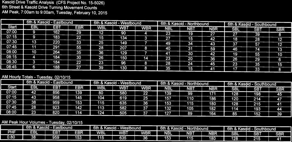
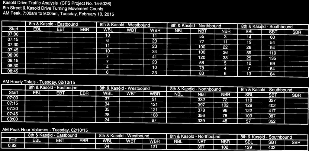
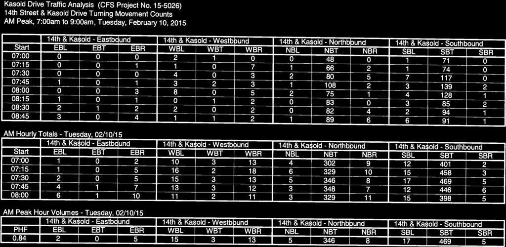
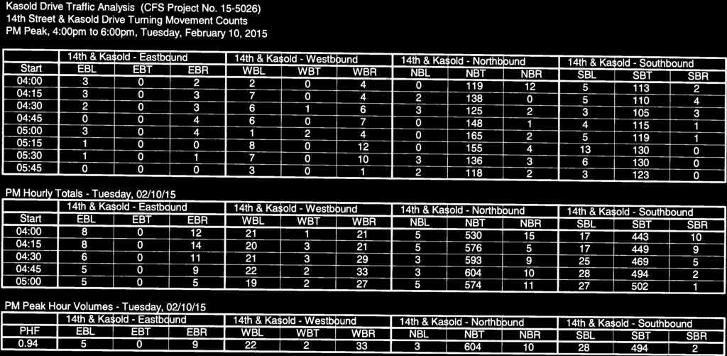
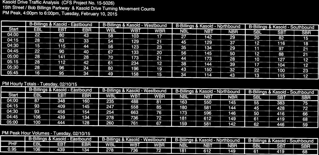
8 Alternate Transportation Mode Choices: Between the City of Lawrence and the University of Kansas, bus service appears to be well-served for the area, and several City and University busses were observed during the traffic counting sessions. The western side of has continuous sidewalks extending all the way from 6 th Street to Bob Billings Parkway to accommodate pedestrians. There are no existing bicycle lanes in the vicinity. Existing Traffic Volumes Count Locations: To get accurate measurements on the existing number of vehicles utilizing Drive from Bob Billings Parkway to 6 th Street / US-4 Highway, CFS organized a coordinated effort to take traffic counts on a typical weekday at six key intersections. Counts were taken during the AM peak hours from 7: am to 9: am, and during the PM peak hours from 4: pm to 6: pm, on the morning and afternoon of Tuesday, February 1, 15. Traffic was counted at the following intersections: 1. 6 th Street / US-4 Highway & Drive. 8 th Street & Drive. Harvard Road & Drive 4. 1 th Street & Drive th Street & Drive 6. Bob Billings Parkway (15 th St) & Drive Count Methods: Counters were stationed at each intersection, and counting time segments were incremented into 15-minute intervals over the two hour morning and two hour afternoon counting sessions. Tuesday, February 1, 15, was selected as a typical weekday with regular traffic loads not skewed by holidays or vacations. Both the Lawrence Public Schools and the University of Kansas were in regular session. The weather was unseasonably mild for February, and a small number of pedestrians and bicyclists were observed during the afternoon counts. The AM and PM peak hour counts were summarized on a schematic map of Drive showing all of the intersections studied. Thru-Counts along : Based on the AM and PM peak hour counts, the southbound traffic was predominantly higher than the northbound between Harvard and Bob Billings Parkway during the morning, with a higher number of northbound motorists during the afternoon. Northbound traffic during the afternoon was noticeably disproportionate between 1 th Street and Bob Billings Parkway with the commercial district on the northwest corner of Bob Billings &. The following table compares the north and southbound traffic volumes along with the total combined volumes for the various roadway segments between the counted intersections along Drive for the present day conditions and for the projected future 4 traffic at ans assumed.5% annual growth: Peak Hour Traffic Volumes along various segments of Drive, Present-Day AM (PM) Roadway Segment Northbound Southbound Total 6 th to 8 th Street 518 (77) vph 51 (589) vph 149 (196) vph 8 th to Harvard Road 499 (56) vph 46 (51) vph 95 (157) vph Harvard to 1 th Street 5 (651) vph 511 (5) vph 864 (1174) vph 1 th to 14 th Street 61 (654) vph 58 (56) vph 869 (118) vph 14 th to Bob-Billings (15 th ) 59 (79) vph 489 (548) vph 848 (18) vph Drive Reconstruction, 6 th St. to Bob Billings Parkway Traffic Impact Study Pg 8
9 Peak Hour Traffic Volumes along various segments of Drive, Future 4 AM (PM) Roadway Segment Northbound Southbound Total 6 th to 8 th Street 61 (799) vph 587 (665) vph 1188 (1464) vph 8 th to Harvard Road 566 (594) vph 49 (6) vph 158 (1194) vph Harvard to 1 th Street 4 (76) vph 579 (591) vph 979 (14) vph 1 th to 14 th Street 49 (79) vph 575 (594) vph 984 (1) vph 14 th to Bob-Billings (15 th ) 46 (89) vph 554 (619) vph 96 (151) vph Drive Reconstruction, 6 th St. to Bob Billings Parkway Traffic Impact Study Pg 9


10 Drive Reconstruction, 6 th St. to Bob Billings Parkway Traffic Impact Study Pg 1
11 Drive Reconstruction, 6 th St. to Bob Billings Parkway Traffic Impact Study Pg 11

12 Drive Reconstruction, 6 th St. to Bob Billings Parkway Traffic Impact Study Pg 1
13 Traffic flow at the intersections with 8 th Street and with Harvard Road were also predominantly one directional with the majority of motorists traveling east towards the University of Kansas in the morning, and returning to the west in the afternoon. The following table compares the east and westbound traffic volumes: Peak Hour Traffic Volumes on approaches to from 8 th St and from Harvard, AM (PM) Approach Eastbound Westbound Total 8 th Street East Approach 1 (1) vph 155 (8) vph 86 (44) vph Harvard Rd - East Approach 15 (159) vph 81 (174) vph 1 () vph Harvard Rd - West Approach 199 (14) vph 6 (199) vph 59 (9) vph Projected Traffic Record Traffic Data: The City had 4-hour record traffic counts available on some segments of and on the east and west approaches of Harvard Road. The measured 15 PM peak hour volumes along Drive appear to correspond with 9 to 11% of the City's record daily traffic counts. The record traffic volumes on the east and west approaches of Harvard Road appear to have held steady or even decreased slightly since Tabulating and comparing the total daily counts against the peak hourly volumes measured during the February 15 field counts yielded the following data: Comparison of Record 4-Hour Traffic Volumes versus 15 Peak Hour Counts, AM (PM) Segment Peak Hr 6 th to 8 th St. 14 th to Bob-B Harvard East App. Harvard West App. 1, vpd 15,65 vpd 1,7 vpd 14,84 vpd 14,75 vpd 149(196)vph 11,15 vpd 1,955 vpd 17,96 vpd 15,78 vpd 1,95 vpd 848(18)vph N/A 55 vpd 9 vpd 75 vpd 5 vpd 1()vph N/A N/A 45 vpd 66 vpd N/A 59(9)vph Growth Rate: The growth factor was calculated based off of the City's record daily traffic counts for estimating future traffic volumes on for the year 4. Record daily traffic counts were available back to the year 198, however, it appears that traffic growth stabilized around 199 where increases appeared to be more consistent. Annual average growth rate percentages were calculated based on the City's record traffic data using the standard formulas as follows: GF = (1 + i)^n-years i= GF^(1/n-years) 1 Drive Reconstruction, 6 th St. to Bob Billings Parkway Traffic Impact Study Pg 1
14 Where the Growth Factor, GF, was the ratio of the final over the beginning traffic volume, i was the annual average growth rate, and n was the duration in years between the beginning and final traffic volumes. Traffic on south of 6 th Street increased from 1,955 vpd in 1995 to 1,95 vpd in 1, indicating that during that 18-year interval, the annual average daily traffic volume grew by approximately.4%. Traffic on north of Bob Billings Parkway increased from 1, vpd in 199 to 14,75 vpd in 1, indicating that during that 1-year interval, the annual average daily traffic volume grew by approximately.5%. Based on the calculated average annual growth rates for the roadway segments at the opposite ends of the roadway improvement limits, an average annual growth factor of.5% was used in projecting traffic volumes 5 years into the future for the year 4 Existing Crash Patterns Crash history was reviewed at the intersection of Harvard &. Police reports from 11 to 14 were available detailing 17 crashess. The following table tabulates the crash history: Harvard Road & Drive Crash History, 11 thru 14 Date Time Injuries Prop Damage Notes 1/18/11 1:18 PM No Yes SB hit NBL w/o stopping (hit & run) 1/8/11 8:1 AM No Yes WB ran into SB (both vehicles initially stopped) /16/1 1:45 AM No Yes NB ran into EB (both vehicles initially stopped) //1 1:5 PM No Yes NB rear-end collision ( cars) 4/15/1 1:8 PM No Yes NBR ran into SBL 9/1/1 1: PM Yes Yes SB ran into WB (neck & shoulder injuries) 1/4/1 9:5 AM No Yes NB ran into EB 1/1/1 5:8 PM No Yes SB rear-end collision ( cars) //1 1:58 PM No Yes NB ran into EB (both vehicles initially stopped) 6/4/1 11:4 AM No Yes NB rear-end collision ( cars) 8/1/1 1: PM Yes Yes SB ran into WB (both vehicles initially stopped, minor injuries) 8//1 9:5 AM No Yes SB ran into WB (both vehicles initially stopped) 11/7/1 6:1 PM No Yes NB ran into EB /1/14 1:4 AM No Yes SB ran into WB (both vehicles initially stopped) 8/1/14 7: PM No Yes SB ran into WB 11//14 1: PM No Yes NB rear-end collision ( cars) 1/5/14 11:8 AM No Yes WB ran into SB (both vehicles initially stopped) Of the 17 crashes reported at the intersection, 7 occurred after both of the colliding vehicles had initially stopped, indicating that the stop-controls with the wide center median has caused some driver confusion on which vehicle Drive Reconstruction, 6 th St. to Bob Billings Parkway Traffic Impact Study Pg 14
15 has the right of way to proceed. There were 4 rear-end collisions and one hit and run. Only two injury crashes with minor injuries. Excluding the two reported crashes in 11, the other three years averaged five crashes per year, which would meet the minimum crash threshold from MUTCD Section 4C.8, Warrant-7, Crash Experience, Condition-B to warrant the installation of a traffic signal at the intersection. Crash history was reviewed at the intersection of 8 th &. Police reports from 1 to 14 were available detailing 6 crashes. The following table tabulates the crash history: 8 th Street & Drive Crash History, 1 thru 14 Date Time Injuries Prop Damage Notes 5//1 1:5 PM No Yes NB ran stop sign and hit WB 1/4/1 5: PM No Yes NB ran stop sign and was hit by SBL /19/1 7:5 PM No Yes SB outside lane turned into SB in inside lane 6/9/1 6:15 AM No Yes NB ran stop sign and hit WB 7/1/1 9:5 AM No Yes NB ran stop sign and hit WB 5/9/14 : PM Yes Yes NB ran stop sign and was hit by SBL Of the six crashes at 8 th &, five were caused by northbound motorists running the stop sign. One crash involved a concussion for the driver. Traffic Signal Analysis Signal Warrant at 8 th & : This T-shaped intersection of a four-lane divided arterial with a residential two-lane collector is currently stop-controlled in all directions. The intersection calms and controls traffic flow to serve the surrounding neighborhoods and Sunset Hill Elementary School further to the east. An examination was made of the MUTCD's traffic signal warrant condition for peak hour traffic conditions. Figure 4C-, Warrant, Peak Hour, requires input for the peak hour traffic volume on the major street for the total of both approaches, and the minor street higher volume approach traffic. Drive, which was the major street, had a total combined approach peak hour volume of 1 vph for the AM conditions, and 1115 vph during the PM conditions. 8 th Street was the minor street with a peak hour approach volume of 151 vph during the AM conditions, and 8 vph for the PM conditions. Entering the major and minor street peak hour traffic volume data into Figure 4C- indicates that a traffic signal is currently warranted at this intersection under the present-day traffic loading volumes. Signal Warrant at Harvard & : This existing four-way stop-control intersection is skewed with the two-lane Harvard Road running east to west, and the four-lane divided Drive angled northwest to southeast. An examination was made of the MUTCD's traffic signal warrant condition for peak hour traffic conditions. Figure 4C-, Warrant, Peak Hour, requires input for the peak hour traffic volume on the major street for the total of both approaches, and the minor street higher volume approach traffic. Drive, which would be the major street, has a total combined approach peak hour volume of 76 vph for the AM conditions, and 186 vph during the PM conditions. Harvard Road would be the minor street with a peak hour approach volume of 199 vph during the AM conditions, and 174 vph for the PM conditions. Entering the major and minor street peak hour traffic volume data into Figure 4C- indicates that a traffic signal is not currently warranted at this intersection under the present-day traffic loading volumes. Extrapolating the volumes at the.5% average Drive Reconstruction, 6 th St. to Bob Billings Parkway Traffic Impact Study Pg 15
16 annual growth factor to the year 4 yields major approach volumes of 86 (1) and minor approach volumes of 5 (197) for the AM (PM) conditions which also does not meet the warrant threshold conditions. The City had traffic counts taken at the Harvard & intersection in November of and found that a signal was warranted for condition (peak hour flow). The City also took counts in August of 4 and found that a signal was warranted for condition 1b (eight-hour flow) and condition (four-hour flow). A traffic signal at Harvard & would be warranted as part of a coordinated signal system between 8 th Street and Bob Billings Parkway. To have coordinated platoons of traffic moving through the Harvard Road intersection would save on potential delay times for individual vehicles entering north-south traffic that would ordinarily have to wait for an opening. Harvard is spaced approximately 4 ft south of 8 th Street and 54 ft north of Bob Billings Parkway, and would serve to maintain platooning of vehicles along. Based on the crash records, the City's counts and warrants done in and 4, and establishing a coordinated signal system for the smooth flow of traffic, a signal is warranted at the Harvard Road & Drive intersection, as part of the Option roadway improvements. Traffic Analysis Synchro Analysis Existing roadway conditions: Drive between 6 th Street and Bob Billings Parkway, is a four-lane, divided roadway with a raised grass center median. There are several median openings to allow full-directional access for the intersecting side streets, but no auxiliary left or right turn lanes except at the commercial developments located at the ends of the project along 6 th Street and along Bob Billings Parkway. is a regular north-south grid street with the exception of the diagonal between 8 th Street and Harvard Road where the alignment veers at roughly 45 degrees northwest/southeast. For northbound motorists, the speed limit is posted at 5 mph just north of Bob Billings Parkway, with a 5 mph warning speed reduction sign located before 8 th Street. For southbound motorists, the speed limit is posted at mph just south of 6 th Street, and posted at 5 mph just south of Harvard Road. There is a continuous sidewalk along the western side of from 6 th Street to Bob Billings Parkway. Portions of the eastern side of by the commercialized areas on the north and south study limits and by the church property south of 9 th Street, also have sidewalks. The intersection of 6 th & is fully signalized with protected left-turn lanes for the east and westbound traffic, and protected/permitted left-turn lanes for the north and southbound traffic. The eastbound approach has a right-turn auxiliary lane. The intersection of Bob Billings Parkway & is fully signalized with protected left-turn lanes for the north and southbound traffic, and protected/permitted left-turn lanes for the east and westbound traffic. There are dividing medians on all four legs of the intersections. Only the northbound approach of the intersection has an auxiliary right-turn lane. The northbound approach also has a striped-out lane next to the existing left-turn lane that could be readily converted to dual left-turn lanes. Option-1 Roadway Improvements: The proposed Option-1 improvements involve road dieting where the existing four-lane divided roadway section would be reduced to a two-lane divided street. The center median would remain intact except where new left-turn auxiliary lanes would be added at key intersections. Right-turn auxiliary Drive Reconstruction, 6 th St. to Bob Billings Parkway Traffic Impact Study Pg 16
17 lanes were not added, but could be considered at key intersections. Continuous bicycle lanes would be added alongside the regular automotive lanes, and the sidewalks on the eastern side of the street would be extended to provide a continuous run from 6 th to Bob Billings Parkway. An 8 ft shared-use path would be constructed on the western side of to connect existing paths south of Bob Billings to existing paths up at 6th Street. The intersections of 8 th & and Harvard & would be re-worked into roundabouts in this option. The intersections at 6 th Street and at Bob Billings Parkway would have pavement and curb replaced, but generally remain intact and unchanged geometrically by the proposed construction. The limiting factor for traffic is the capacity of the roundabout. Along regular straight grid road segments, the normal maximum peak hour capacity is approximately 18 vph for a single street lane or approximately 6 vph for double lanes. The individual street lane capacity of a single lane roundabout totals approximately 1 vph (this includes entering traffic flow plus conflicting traffic flow already turning through the roundabout), and approximately 18 vph for a double lane roundabout. Besides the roundabout, the driveways and side-roads may cause some decreases in speed for the north and southbound traffic. By adding a dedicated bike lane near a major University, the speed differences caused by vehicles slowing to follow cyclists will no longer be an issue and should help to decrease delays and increase capacity. Option- Roadway Improvements: For the proposed Option- improvements, the four-lane divided roadway section would remain intact, and the intersection of Harvard & would be signalized. The center median would remain intact except where new left-turn auxiliary lanes would be added at key intersections. Right-turn auxiliary lanes were not added, but could be considered to be added by the City at key intersections. Continuous bicycle lanes would be added alongside the regular automotive lanes, and the sidewalks on the eastern side of the street would be extended to provide a continuous run from 6 th to Bob Billings Parkway. An 8 ft shared-use path would be constructed on the western side of to connect existing paths south of Bob Billings to existing paths up at 6th Street. A stop sign was modeled at 8th Street in this option since it currently exists. The approach legs of the intersections at 6 th Street and at Bob Billings Parkway would have pavement and curb replaced, but would generally remain intact and unchanged geometrically by the proposed construction. Option-B & Option-C Modifications for 8 th & : For the base Option- improvements where the T-intersection of 8 th & would be left as a three-way stop, Option-B included a variation to remove the stop-signs from the north and southbound movements and keep the stop sign on the westbound approach. The Option-C variation included adding a signal to the 8 th & intersection. For the Option-B modifications with the removal of the north and southbound stop signs, a pedestrian crossing signal could be added to the intersection. For either of the proposed improvements for the 8 th & intersection, a raised pedestrian crossing could also be constructed for traffic calming (construction of a raised pedestrian crossing could also be considered as part of the Option-1 improvements). Synchro Model Categorization: Synchro models of Drive were created to simulate the traffic volumes, delays, level-of-service and queue lengths. There were three basic roadway models including: 1. Pre-Development Conditions (Existing Roadway Characteristics).. Post-Development Option-1 with Lane Dieting (Reduction to One North and One Southbound Lane) with Roundabouts at Harvard Road and at 8 th Street.. Post-Development Option- keeping the Four-Lane Divided Roadway Configuration with a signal at Harvard Road. Drive Reconstruction, 6 th St. to Bob Billings Parkway Traffic Impact Study Pg 17
18 For each of the three base scenarios, the present-day and projected future traffic for the year 4 were used for the traffic volumes for both the AM and PM Peak Hour Traffic Conditions. The categorization of all twenty different combinations analyzed using Synchro were as follows: Pre-Development (Existing Roadway Conditions) Synchro Models: 1. Pre-Development, Present-Day Traffic, AM Peak Hour. Pre-Development, Present-Day Traffic, PM Peak Hour. Pre-Development, Future Growth to Year 4 Traffic, AM Peak Hour 4. Pre-Development, Future Growth to Year 4 Traffic, PM Peak Hour Option-1 (Roadway Dieting to Two-Lanes with Roundabouts at 8 th and at Harvard) Synchro Models: 5. Post-Development Option-1 (Roundabouts), Present-Day Traffic, AM Peak Hour 6. Post-Development Option-1 (Roundabouts), Present-Day Traffic, PM Peak Hour 7. Post-Development Option-1 (Roundabouts), Future Growth to Year 4 Traffic, AM Peak Hour 8. Post-Development Option-1 (Roundabouts), Future Growth to Year 4 Traffic, PM Peak Hour Option- (Hold Four-Lanes with Signal at Harvard) Synchro Models: 9. Post-Development Option- (Harvard Signal), Present-Day Traffic, AM Peak Hour 1. Post-Development Option- (Harvard Signal), Present-Day Traffic, PM Peak Hour 11. Post-Development Option- (Harvard Signal), Future Growth to Year 4 Traffic, AM Peak Hour 1. Post-Development Option- (Harvard Signal), Future Growth to Year 4 Traffic, PM Peak Hour In addition, Option- was further sub-analyzed with 8 th & modified to remove the stop-controls from the north and southbound lanes (Option-B), and with the intersection of 8 th & signalized (Option-C) Option-B (Option- with 8 th & Intersection Modified to Remove Stop-Control from North and Southbound Lanes) Synchro Models: 1. Post-Development Option-B (Harvard Signal, Modified 8 th Stops), Present-Day Traffic, AM Peak Hour 14. Post-Development Option-B (Harvard Signal, Modified 8 th Stops), Future 4 Traffic, AM Peak Hour 15. Post-Development Option-B (Harvard Signal, Modified 8 th Stops), Present-Day Traffic, PM Peak Hour 16. Post-Development Option-B (Harvard Signal, Modified 8 th Stops), Future 4 Traffic, PM Peak Hour Option-C (Option- with 8 th & Intersection Signalized) Synchro Models: 17. Post-Development Option-C (Signals at Harvard and at 8 th Street), Present-Day Traffic, AM Peak Hour 18. Post-Development Option-C (Signals at Harvard and at 8 th Street), Future 4 Traffic, AM Peak Hour 19. Post-Development Option-C (Signals at Harvard and at 8 th Street), Present-Day Traffic, PM Peak Hour. Post-Development Option-C (Signals at Harvard and at 8 th Street), Future 4 Traffic, PM Peak Hour Synchro Results: Print-outs of the summary tables from the Synchro models have been included in the appendix of this report. The intersections of 6 th &, and Bob Billings Parkway & will remain unaltered by the proposed construction improvements. The intersections of 1 th & and 14 th &, with their low volume of cross-street traffic, would be minimally impacted by either the Option-1 or Option- improvements. Roadway Dieting Lane Reduction: Looking at the north and southbound traffic volumes on roadway segments that would be subjected to lane reductions under the proposed Option-1 improvements, the northbound PM peak hour traffic lanes between Harvard and 1 th Street carried 651 vph under the present-day conditions, which would grow to 78 vph when increased by.5% annual growth over 5-years to 4. The maximum volume that a single lane of traffic can carry is 19 vph, of which the future projected traffic volume of 78 vph is less than 4%. Drive Reconstruction, 6 th St. to Bob Billings Parkway Traffic Impact Study Pg 18
19 8 th Street & Drive: In comparing the Synchro output results for the pre-development, Option-1 (roundabout), Option-B (free north and south traffic w/ stopped westbound leg), and Option-C (signalized) conditions, a table summarizing the delays and level-of-service values was compiled as follows: Approach Westbound Northbound Southbound 8 th & Comparison of Synchro Results, Present-Day Traffic Volumes, AM (PM) Pre-Dev (Existing) LOS / Delay(s) Option-1 (Roundabout) LOS / Delay(s) Option- (-Way Stop) LOS / Delay(s) Option-B (E-Leg Stop) LOS / Delay(s) Option-C (Signal) LOS / Delay(s) B (C) A (B) B (C) C (D) A (A) 11.9 (15.1) 8.8 (1.) 11.9 (15.1) 1.9 (6.7) 6.4 (6.8) B (C) B (B) B (C) A (A) A (A) 14. (16.6) 1.6 (1.6) 14. (16.6) ().9 (5.5) C (C) B (B) C (C) A (A) A (A) 15.7 (17.) 11.6 (11.7) 15.7 (17.).8 (1.7) 5.5 (6.5) Approach Westbound Northbound Southbound 8 th & Comparison of Synchro Results, Future 4 Traffic Volumes, AM (PM) Pre-Dev (Existing) LOS / Delay(s) Option-1 (Roundabout) LOS / Delay(s) Option- (-Way Stop) LOS / Delay(s) Option-B (E-Leg Stop) LOS / Delay(s) Option-C (Signal) LOS / Delay(s) B (C) B (C) B (C) D (F) A (A) 1. (18.1) 1. (15.7) 1. (18.1) 4.5 (5.7) 6.5 (9.5) C (D) C (B) C (D) A (A) A (A) 19. (6.1) 18.1 (1.8) 19. (6.1) () 4. (6.9) C (D) B (B) C (D) A (A) A (A) 19. (5.5) 14. (14.4) 19. (5.5) 1. (9.) 6. (8.7) The Synchro results show that either Option-1 with the roundabout or Option-C with a signal would improve traffic flow with reduced delay times and increased level-of-service ratings for the three approaches to the 8 th & intersection. The westbound traffic would see the largest improvement. Option-B with the removal of the stop-signs for the north and southbound movements at the intersection would cause a large increase in delay and reduction in level-of-service for westbound motorists, who would have to wait for cross-traffic to clear before executing their right and left-turning movements. The volume of vehicles backed-up in queue on the westbound approach would increase, accordingly. While Option-C with the traffic signal does provide better level-of-service ratings and shorter delays, there is also long-term equipment maintenance to contend with in the installation of a signal and controller compared to a roundabout. Also noteworthy is the reduction in the approach Drive Reconstruction, 6 th St. to Bob Billings Parkway Traffic Impact Study Pg 19
20 delay times between the Option-1 roundabout configuration compared to the existing conditions with the -way stop-control intersection, which indicates that the lane dieting at this intersection would be able to convey the same volume of vehicles as the existing four-lane divided street. Harvard Road & Drive: When comparing the Synchro output results for the pre-development, Option-1 (roundabout) and Option- (signalized) conditions, the following table summarizing the delays and level-of-service values was compiled: Harvard & Comparison of Synchro Results, Present-Day Traffic Volumes, AM (PM) Pre-Dev (Existing) Option-1 (Roundabout) Option- (Signal) Approach LOS / Delay(s) LOS / Delay(s) LOS / Delay(s) Eastbound Westbound Northbound Southbound B (B) B (A) B (B) 1. (1.7) 1.1 (8.1) 11.4 (1.4) B (B) A (A) A (B) 11. (1.8) 6. (9.6) 9.4 (15.6) B (C) A (B) A (A) 1.4 (17.) 9. (1.8) 8.4 (6.9) B (B) A (B) A (B) 1. (14.8) 9. (11.7) 8.8 (11.) Harvard & Comparison of Synchro Results, Future 4 Traffic Volumes, AM (PM) Pre-Dev (Existing) Option-1 (Roundabout) Option- (Signal) Approach LOS / Delay(s) LOS / Delay(s) LOS / Delay(s) Eastbound Westbound Northbound Southbound C (B) B (A) B (B) 15. (14.) 1.1 (9.) 1.1 (1.) B (C) A (B) A (B) 1. (15.8) 6.9 (11.5) 9.8 (16.6) B (C) B (C) A (A) 14. (.4) 1.4 (16.) 9. (7.4) C (C) B (B) A (B) 15.6 (16.1) 1.6 (14.6) 9.5 (11.6) Drive Reconstruction, 6 th St. to Bob Billings Parkway Traffic Impact Study Pg
21 The results from either Option-1 (roundabouts) or Option- (signal) show improvement from the pre-development conditions. For the Option-1 conditions with the proposed roundabout, level-of-service ratings either held or increased one point for both the AM and PM peak hour conditions, and the delays all reduced, further indicating that the lane diet reduction would show minimal impact on. Option- with the proposed traffic signal also showed increased level-of-service ratings and decreased delays, especially for the higher volume north and southbound approaches, which would benefit from the elimination of the forced stops at Harvard. Travel Time Analysis A travel time analysis was done to calculate how long it would take for vehicles on to drive between 6 th Street and Bob Billings Parkway. Based on the distances between the intermediate intersections, speed limit and start-stop delays, the following table summarizes the travel times for north and southbound passenger vehicles: Travel Times along Drive between 6 th Street and Bob Billings Parkway Pre-Dev (min.) NB SB - Total Option-1 (min.) NB SB - Total Option- (min.) NB SB - Total Option-B (min.) NB SB - Total Option-C (min.) NB SB - Total AM Present-Day PM Present-Day AM Future PM Future The results show that Option-B, with the free movement of traffic with the removal of the north and southbound stop signs at 8 th Street, has the shortest north-south travel times, however, the eastern leg of 8 th Street with a forced stop experiences higher delays. Option-C with the coordinated signals at the intersections of 8 th & and at Harvard & gives the next best travel times. The Option-1 roundabouts slightly edges-out the Option- signal at Harvard with the stop-control at 8 th Street. All of the proposed improvements show decreased drive times compared to the existing conditions with the stop-controlled intersections at 8 th Street and at Harvard. The complete travel time calculations have been included in Appendix C. Summary Findings Based on the traffic counts, estimated growth factors and the results of the Synchro models for the existing roadway conditions, the proposed Option-1 and the proposed Option- conditions, the following recommendations were made for improving the different intersections along Drive: Bob Billings Parkway & : The northern approach to the existing intersection of Bob Billings Parkway & Drive would not require any modifications to the left turn lane or warrant the addition of an auxiliary right-turn lane. The existing southbound left turn lane has a storage length of approximately 15 ft, whereas the worst-case traffic loading scenario (Future 4 AM SBL movement) had a calculated 95 th percentile queue length of 67 ft. The existing southbound left-turn lane appears to have adequate length to accommodate the future traffic loads. Drive Reconstruction, 6 th St. to Bob Billings Parkway Traffic Impact Study Pg 1
22 In regards to any need for an auxiliary southbound right-turn lane, the worst-case loading scenario (Future 4 PM SBR movement) had a volume of 77 vph. Checking the 1 KDOT Access Management Policy, Table 4-6, Right-turn treatment guidelines for four-lane highways, with an operating speed of 4 mph (posted speed limit was 5 mph), and the estimated directional design hourly volume, DDHV = 61 vph, the threshold right-turn volume warranting a right-turn lane would be 151 vph, and the threshold volume warranting a right-turn taper would be 76 vph. A right-turn taper barely meets the warrant threshold for the future conditions estimated for the year 4, but it is not recommended that the intersection be modified to add one since it is not presently warranted. 14 th & : The measured volume of right and left-turn movements for the northbound approach were too low to warrant any auxiliary lanes or tapers, however it is recommended that a northbound left-turn lane be added in the median. The low volume of southbound right-turn movements does not warrant an auxiliary right-turn lane, but a southbound left-turn lane appears to be warranted. Checking the 1 KDOT Access Management Policy, Table 4-8, Recommended left-turn lane warrants for four-lane highways, the PM peak hour opposing volume of northbound traffic that a southbound left-turning motorist would need to cross, Vo = 617 vph, for a four-lane divided highway, would allow for a threshold volume of 1 left-turn movements. The measured PM peak volume of southbound left-turn movements was 8 vph, thus exceeding the minimum threshold volume and warranting a left-turn lane. For the proposed Option-1 improvements with the reduction in lanes on from four lanes to two, north of the intersection with 14 th Street, the maximum southbound left-turn 95 th percentile queue length was calculated to be less than a single vehicle length. The distance from the end of the proposed left-turn lane to the transitional taper on the southbound lanes was set at a distance of approximately 8 ft. 1 th & : The measured volumes of right and left-turn movements for the north and southbound approaches were too low to warrant auxiliary turn lanes, however, 8 ft long left-turn lanes have been added into the center median for the north and southbound movements for both the proposed Option-1 and Option- roadway improvements. Harvard Road & Drive: For the proposed Option-1 improvements, the existing intersection would be reconstructed as a roundabout with a single circular lane. On the southeastern quadrant of the roundabout, an additional northbound right-turn lane could be added to improve the over 9-degree turning movement. For the proposed Option- improvements, the intersection would be fully signalized with new north and southbound left-turn lanes constructed in the center median. The north and southbound left-turns would be permitted and protected. The east and west legs would remain single lanes due to the side restrictions with the established homes fronting Harvard Road. For the northbound right-turn movement, an auxiliary lane is not warranted according to the 1 KDOT Access Management Policy, Table 4-6, Right-turn treatment guidelines for four-lane highways, with an operating speed of 4 mph (posted speed limit was 5 mph), and the estimated directional design hourly volume, DDHV = 614 vph, the threshold right-turn volume warranting a right-turn lane would be 151 vph, and the threshold volume warranting a right-turn taper would be 76 vph. The southbound right-turn movement volumes were too small to warrant a turn lane. 8 th Street & Drive: For the proposed Option-1 improvements, the existing intersection would be reconstructed as a roundabout with a single circular travel lane. Comparing the level-of-service ratings and delay times for the north, south and east approach lanes, the roundabout option improves on these values for all approaches over the existing three-way stop conditions. For the proposed Option- improvements, the intersection of 8 th & would remain unaltered in its existing condition as a three-way stop configuration. A southbound left-turn lane would be added to the median to help Drive Reconstruction, 6 th St. to Bob Billings Parkway Traffic Impact Study Pg
23 facilitate the relatively high number of movements (19 vph during the AM peak hour and 9 vph during the PM peak). A northbound right turn lane is not practical due to the existing house and driveway on the southeast corner. If the existing three-way stop-control intersection were modified to remove the stops for the north and southbound traffic, as proposed by Option-B, the values for delays and level-of-service for the remaining stop-controlled eastern approach would suffer. The westbound approaches level-of-service would drop by one grade for both the AM and PM peak hour conditions, and the corresponding delays would nearly double over the existing conditions. Signalizing the 8 th & intersection, as proposed by Option-C, would improve the level-of -service ratings for all directions of the intersection to LOS-A. A signal option could also incorporate pedestrian crossing signals for walkers and schoolchildren going to and from Sunset Hill Elementary School. 6 th Street & Drive: The existing intersection of 6 th & would be left unaltered by the proposed improvements. The northbound approach already has a 14 ft left-turn lane (the worst-case 95 th percentile queuing length was 48 ft during the PM peak hour). The northbound right-turn volume readily meets the threshold level for recommending construction of a right-turn lane according to the 1 KDOT Access Management Policy, Table 4-6, Right-turn treatment guidelines for four-lane highways, however, with the low volume of northbound thru movement traffic, the occasional thru motorist blocking right-turning drivers should not cause undue delays or back-ups. Conclusions The intersections of 8 th Street and Harvard Road with Drive were analyzed with the different Synchro models of the existing conditions/option-1 lane diet and roundabouts/option- signals, for the AM and PM peak hour conditions for present-day and estimated future growth traffic volumes. The other intersections figured into the Synchro Analysis at 6 th, 1 th, 14 th and at Bob Billings Parkway would be minimally impacted by the proposed construction improvements. Option-1's road dieting, with the reduction in lanes from four to two, showed improved capacity over the existing stop-controlled intersections at 8 th Street and at Harvard Road, attributable to the roundabouts ability to keep traffic in constant motion without having to stop. Both the AM and PM peak hour traffic at 8 th Street showed increased level-of-service ratings for all approaches with the proposed roundabout, and helped the PM peak hour avoid LOS-D's for the north and southbound traffic projected with the future growth in 4. The proposed Harvard Road roundabout also increased the level-of-service ratings by one level for all approaches during both the AM and PM peak hours, and helped decrease the northbound delays from 4 seconds to 16. seconds during the PM peak hour future 4 growth conditions. The Option-1 design would allow for a wider vehicular lane along with the designated bicycle lane to provide more buffer clearance and inherently safer conditions for alternative traffic modes. The bicycle lanes would keep slower moving bicyclists from delaying automotive traffic. The proposed roadway section would also be less intrusive on cutting into the center median for left-turn lanes. The roundabouts help to calm traffic with motorists slowing as they negotiate the circular turning movements. There is an existing roundabout at the intersection of Harvard & Monterey Way just west of, along with several others located throughout the City, so local residents have become acclimated to driving through them. Roundabouts also have zero operating costs compared to traffic signals which will require regular maintenance and attention along with equipment upgrades. Similar road designs featuring a road diet (decreasing of the number of through lanes) usually have not increased the traffic demand. Neither increased or decreased traffic volumes on are expected as a result of the construction of the proposed roundabouts at 8 th Street and at Harvard Road, or as a result of the lane reduction road dieting. One disadvantage to the roundabouts are the limited amount of existing right-of-way and the Drive Reconstruction, 6 th St. to Bob Billings Parkway Traffic Impact Study Pg
24 locations of the existing driveways that would need to be incorporated into the design. Another disadvantage with the roundabouts and the limited right-of-way would be that the diameters would be constrained, and truck and bus traffic would be likely to drive over the curbs. The bicycle lanes cannot be routed through the roundabouts, and bicyclists would have to drive over sidewalk ramps to skirt around the intersection. Option- would keep the four-lane street configuration intact to allow for regular right and left-turn lanes while keeping the thru-lanes open to allow traffic flow. The four-lane configuration would also be more accommodating for truck and bus traffic. The proposed signal at Harvard Road would increase the level-of service ratings for north and southbound traffic during both the AM and PM peak hours for the present day and future 4 traffic volumes. With the existing houses and driveways along several portions of (particularly on the western side), the bicycle lanes would have to remain on the outside with the 11 ft vehicular lanes cutting into the center median. The four-lane configuration would be less conducive to calming traffic, with faster motorists passing slower drivers. The delays, level-of-service ratings and queue lengths for vehicles periodically stopped for signals would improve over the existing conditions with the four-way stop at the intersection at Harvard &. A signal system timed and coordinated with the existing signalized intersections at 6 th Street and at Bob Billings Parkway would benefit motorists by cutting down on stop delays at intersections. The traffic signals would have substantial costs for the poles, controllers and electrical components, along with the required long-term maintenance and upkeep requirements. The Option-B alternative with the removal of stop signs for the north and southbound movements at 8 th Street does not appear to be a viable option. Delays and level-of-service ratings notably improve with the unrestricted movement for the north and southbound drivers, at the expense of the forced-stop westbound traffic which would see increases in delays from 11. seconds to 1.9 seconds during the AM peak hour, and from 1.8 seconds to 6.7 seconds during the PM peak. Level-of-service ratings would decrease correspondingly. The Option-C alternative calling for the signalization of the 8 th & intersection would fare much better than either Option or Option B, with LOS-A ratings for all movement directions and delays below 7 seconds for both the AM and PM peak hours. The present-day traffic volumes at 8 th & also warrant a signal under MUTCD's Warrant- peak hour conditions. The distance between 6 th and 8 th Streets is approximately 7 ft, so the proposed signal would have to be coordinated to prevent undue timing delays for motorists. A signal at Harvard would be warranted for coordinating signal systems along the corridor between 6 th and Bob Billings. This option would keep the existing roadway's divided four-lane character while providing for bicycle lanes on both sides of the street. Option-C had lower overall travel time compared to the Option-1 roundabouts and the Option- signal only at Harvard. Drive Reconstruction, 6 th St. to Bob Billings Parkway Traffic Impact Study Pg 4
25 Drive Improvements 6 th Street to 15 th Street / Bob Billings Parkway Lawrence, Kansas 6644 CFS Project No Traffic Impact Study June, 15 Appendix A Maps and Exhibits Drive Improvement Plans,Option-1, Road Dieting with Roundabouts Drive Improvement Plans,Option-I1, Four-Lane with Signals
26 Drive Improvements 6 th Street to 15 th Street / Bob Billings Parkway Lawrence, Kansas 6644 CFS Project No Traffic Impact Study June, 15 Appendix B Traffic Counts & Record Traffic Count Maps Weekday AM Peak Hour (7: to 9:am), Tuesday, February 1, 15 Weekday PM Peak Hour (4: to 6:pm), Tuesday, February 1, 15
27
28
29
30
31
32

33

34
35
36
37
38
Traffic Impact Study WestBranch Residential Development Davidson, NC March 2016
 Traffic Impact Study WestBranch Residential Development Davidson, NC March 216 TRAFFIC IMPACT STUDY FOR THE WestBranch Residential Development LOCATED IN DAVIDSON, NC Prepared For: Lennar Carolinas, LLC
Chapter 4 Traffic Analysis
 Chapter 4 Traffic Analysis PURPOSE The traffic analysis component of the K-68 Corridor Management Plan incorporates information on the existing transportation network, such as traffic volumes and intersection
MEMORANDUM. Charlotte Fleetwood, Transportation Planner
 MEMORANDUM Date: Updated August 22, 2017 To: Organization: Charlotte Fleetwood, Transportation Planner Boston Transportation Department From: Jason DeGray, P.E., PTOE, Regional Director of Engineering
Traffic Impact Analysis Chatham County Grocery Chatham County, NC
 Chatham County Grocery Chatham County, NC TABLE OF CONTENTS 1. INTRODUCTION... 1 1.1. Location and Study Area... 1 1.2. Proposed Land Use and Access... 2 1.3. Adjacent Land Uses... 2 1.4. Existing ways...
CITY OF WEST LAKE HILLS. Forest View Neighborhood Traffic Calming Study
 CITY OF WEST LAKE HILLS 901 South Mopac Expressway Building V, Suite 220 Austin, Texas 78746 Texas P.E. Firm Registration No. F-929 Klotz Associates Final Report Submittal: March 20, 2015 Revised Final
Truck Climbing Lane Traffic Justification Report
 ROUTE 7 (HARRY BYRD HIGHWAY) WESTBOUND FROM WEST MARKET STREET TO ROUTE 9 (CHARLES TOWN PIKE) Truck Climbing Lane Traffic Justification Report Project No. 6007-053-133, P 101 Ι UPC No. 58599 Prepared by:
Road Conversion Study Plumas Street
 Plumas Street Phase I Submitted to The Regional Transportation Commission of Washoe County Submitted by Zong Tian, Ph.D., P.E. Saeedeh Farivar Haiyuan Li, Ph.D. Center for Advanced Transportation Education
TRANSPORTATION ANALYSIS REPORT US Route 6 Huron, Erie County, Ohio
 TRANSPORTATION ANALYSIS REPORT US Route 6 Huron, Erie County, Ohio December 12, 2012 Prepared for: The City of Huron 417 Main Huron, OH 44839 Providing Practical Experience Technical Excellence and Client
Walmart (Store # ) 60 th Street North and Marion Road Sioux Falls, South Dakota
 60 th Street North and Marion Road Sioux Falls, South Dakota") Walmart (Store #4865-00) 60 th Street North and Marion Road Sioux Falls, South Dakota Prepared for: Wal-Mart Stores, Inc. Bentonville, Arkansas Prepared by: Kimley-Horn and Associates, Inc. ã2013 Kimley-Horn
Walmart (Store #4865-00) 60 th Street North and Marion Road Sioux Falls, South Dakota Prepared for: Wal-Mart Stores, Inc. Bentonville, Arkansas Prepared by: Kimley-Horn and Associates, Inc. ã2013 Kimley-Horn
Traffic Impact Analysis Walton Acres at Riverwood Athletic Club Clayton, NC
 Traffic Impact Analysis Walton Acres at Riverwood Athletic Club Clayton, NC 1. TABLE OF CONTENTS INTRODUCTION...1 1.1. Site Location and Study Area...1 1.2. Proposed Land Use and Site Access...2 1.3.
Traffic Impact Memorandum. May 22, 2018
 BISHOP PROFESSIONAL DEVELOPMENT BUILDING Proposed Land-use Change & Parking Modification 3601 SW 31st Street Topeka, Kansas 66614 CFS Project No. 185077 Traffic Impact Memorandum May 22, 2018 Prepared
DEPARTMENT OF ENVIRONMENTAL SERVICES. North Harrison Street (Lee Highway to Little Falls Road) Comparative Analysis. Prepared for:
 Comparative Analysis. Prepared for:") DEPARTMENT OF ENVIRONMENTAL SERVICES North Harrison Street (Lee Highway to Little Falls Road) Comparative Analysis Prepared for: Arlington County Department of Environmental Services 2100 Clarendon Boulevard,
DEPARTMENT OF ENVIRONMENTAL SERVICES North Harrison Street (Lee Highway to Little Falls Road) Comparative Analysis Prepared for: Arlington County Department of Environmental Services 2100 Clarendon Boulevard,
OFFICE/RETAIL DEVELOPMENT 1625 BANK STREET OTTAWA, ONTARIO TRANSPORTATION BRIEF. Prepared for: Canada Inc.
 OFFICE/RETAIL DEVELOPMENT 1625 BANK STREET OTTAWA, ONTARIO TRANSPORTATION BRIEF Prepared for: 9402209 Canada Inc. December 15, 2015 115-625 Report_2.doc D. J. Halpenny & Associates Ltd. Consulting Transportation
Capital Region Council of Governments
 March 23, 2018 Capital Region Council of Governments PROJECT CONCEPT REPORT Realignment of Swamp and Northfield Road s approaches to Route 44 (Boston Turnpike) Town of Coventry SUMMARY: The Town of Coventry
DRAFT. Corridor study. Honeysuckle Road. October Prepared for the City of Dothan, AL. Prepared by Gresham, Smith and Partners
 DRAFT Corridor study Honeysuckle Road October 2017 Prepared for the City of Dothan, AL Prepared by TABLE OF CONTENTS SECTION I... 1 STUDY SUMMARY... 1 INTRODUCTION... 1 CONCLUSIONS... 5 SECTION II... 7
Glenn Avenue Corridor Traffic Operational Evaluation
 Glenn Avenue Corridor Traffic Operational Evaluation PREPARED FOR: THE CITY OF AUBURN PREPARED BY: DECEMBER 2007 Glenn Avenue Corridor Study--Auburn, Alabama TABLE OF CONTENTS Introduction... 1 Background
Harrah s Station Square Casino
 Transportation Analysis Harrah s Station Square Casino Pittsburgh, Pennsylvania Submitted To: City of Pittsburgh and Pennsylvania Gaming Control Board Prepared By: DKS Associates GAI Consultants December
ALLEY 24 TRAFFIC STUDY
 ALLEY 24 TRAFFIC STUDY in City of Frostburg, Maryland January 2013 3566 Teays Valley Road Hurricane, WV Office: (304) 397-5508 www.denniscorporation.com Alley 24 Traffic Study January 2013 Frostburg, Maryland
Windy Ridge Elementary School
 Windy Ridge Elementary School SCHOOL ROUTE PLAN For WINDY RIDGE ELEMENTARY SCHOOL LOCATION 54 ORANGE COUNTY Prepared for: ORANGE COUNTY SCHOOL ASSESSMENT PROGRAM ORANGE COUNTY PUBLIC WORKS Traffic Engineering
TRAFFIC IMPACT ANALYSIS
 TRAFFIC IMPACT ANALYSIS FOR THE CHAMPAIGN UNIT#4 SCHOOL DISTRICT PROPOSED HIGH SCHOOL (SPALDING PARK SITE) IN THE CITY OF CHAMPAIGN Final Report Champaign Urbana Urbanized Area Transportation Study 6/24/2014
Existing Conditions. Date: April 16 th, Dan Holderness; Coralville City Engineer Scott Larson; Coralville Assistant City Engineer
 Date: April 16 th, 2015 To: From: Re: Dan Holderness; Coralville City Engineer Scott Larson; Coralville Assistant City Engineer Darian Nagle-Gamm, Traffic Engineering Planner Highway 6 (2 nd Street) /
METHODOLOGY. Signalized Intersection Average Control Delay (sec/veh)
") Chapter 5 Traffic Analysis 5.1 SUMMARY US /West 6 th Street assumes a unique role in the Lawrence Douglas County transportation system. This principal arterial street currently conveys commuter traffic
Chapter 5 Traffic Analysis 5.1 SUMMARY US /West 6 th Street assumes a unique role in the Lawrence Douglas County transportation system. This principal arterial street currently conveys commuter traffic
TRAFFIC SIGNAL WARRANT STUDY
 TRAFFIC SIGNAL WARRANT STUDY 5 th STREET & ENCHANTED PINES DRIVE JANUARY 2013 TRAFFIC OPERATIONS ENGINEERING SERVICES/PUBLIC WORKS DEPARTMENT TABLE OF CONTENTS INTERSECTION LOCATION MAP ii INTRODUCTION
DOWNTOWN TUPELO MAIN STREET: ROAD DIET STUDY
 DOWNTOWN TUPELO MAIN STREET: ROAD DIET STUDY Since mid-2009, RPM Transportation Consultants (RPM) has worked with the Downtown Tupelo Main Street Association to evaluate traffic conditions and potential
Shockoe Bottom Preliminary Traffic and Parking Analysis
 Shockoe Bottom Preliminary Traffic and Parking Analysis Richmond, Virginia August 14, 2013 Prepared For City of Richmond Department of Public Works Prepared By 1001 Boulders Pkwy Suite 300, Richmond, VA
Evaluation of M-99 (Broad Street) Road Diet and Intersection Operational Investigation
 Road Diet and Intersection Operational Investigation") Evaluation of M-99 (Broad Street) Road Diet and Intersection Operational Investigation City of Hillsdale, Hillsdale County, Michigan June 16, 2016 Final Report Prepared for City of Hillsdale 97 North Broad
Evaluation of M-99 (Broad Street) Road Diet and Intersection Operational Investigation City of Hillsdale, Hillsdale County, Michigan June 16, 2016 Final Report Prepared for City of Hillsdale 97 North Broad
5858 N COLLEGE, LLC N College Avenue Traffic Impact Study
 5858 N COLLEGE, LLC nue Traffic Impact Study August 22, 2016 Contents Traffic Impact Study Page Preparer Qualifications... 1 Introduction... 2 Existing Roadway Conditions... 5 Existing Traffic Conditions...
Donahue Drive Corridor Traffic Operational Evaluation
 Donahue Drive Corridor Traffic Operational Evaluation PREPARED FOR: THE CITY OF AUBURN PREPARED BY: JANUARY 2007 Donahue Drive Corridor Study--Auburn, Alabama TABLE OF CONTENTS Introduction... 1 Background
9 Leeming Drive Redevelopment Ottawa, ON Transportation Brief. Prepared By: Stantec Consulting Ltd.
 9 Leeming Drive Redevelopment Ottawa, ON Transportation Brief Prepared By: Stantec Consulting Ltd. TIA GUIDELINES CHECKLIST Report Context Municipal Address Comment: Section 1.1 Location relative to major
THIS PAGE LEFT BLANK INTENTIONALLY
 GA SR 25 Spur at Canal Road Transportation Impact Analysis PREPARED FOR GLYNN COUNTY, GEORGIA 1725 Reynolds Street, Suite 300 Brunswick, Georgia 31520 PREPARED BY 217 Arrowhead Boulevard Suite 26 Jonesboro,
Lincoln Avenue Road Diet Trial
 Lincoln Avenue Road Diet Trial Data Collection Report June 1, 2015 Department of Transportation Table of Contents I. Introduction...... 3 II. Data Collection Methodology & Results...... 5 A. Traffic Volume
Transportation Impact Study for Abington Terrace
 Transportation Impact Study for Abington Terrace Abington Township, Montgomery County, PA Sandy A. Koza, P.E., PTOE PA PE License Number PE059911 Prepared by McMahon Associates, Inc. 425 Commerce Drive,
University Hill Transportation Study Technical Memorandum Alternatives Modeling and Analysis May 2007
 Technical Memorandum May 2007 Syracuse Metropolitan Transportation Council Edwards and Kelcey with Wallace Roberts and Todd Alta Planning and Design CONTENTS SECTION ONE- INTRODUCTION...1 SECTION TWO-
INDUSTRIAL BUILDING 3009 HAWTHORNE ROAD CITY OF OTTAWA TRANSPORTATION OVERVIEW REVISED. Prepared for: Canada Inc.
 INDUSTRIAL BUILDING 3009 HAWTHORNE ROAD CITY OF OTTAWA TRANSPORTATION OVERVIEW REVISED Prepared for: 7849648 Canada Inc. Octiober 1, 2015 114-598 Overview_2.doc D. J. Halpenny & Associates Ltd. Consulting
Lake Whitney Elementary School
 Lake Whitney Elementary School SCHOOL ROUTE PLAN For LAKE WHITNEY ELEMENTARY SCHOOL LOCATION 18 ORANGE COUNTY Prepared for: ORANGE COUNTY SCHOOL ASSESSMENT PROGRAM ORANGE COUNTY PUBLIC WORKS Traffic Engineering
Route 28 (South Orleans Road)/Route 39 (Harwich Road)/Quanset Road Intersection
/Route 39 (Harwich Road)/Quanset Road Intersection") TRAFFIC FEASIBILITY STUDY Route 28 (South Orleans Road)/Route 39 (Harwich Road)/Quanset Road Intersection Orleans, Massachusetts Prepared for: Town of Orleans Prepared by: Fay, Spofford & Thorndike, LLC
TRAFFIC FEASIBILITY STUDY Route 28 (South Orleans Road)/Route 39 (Harwich Road)/Quanset Road Intersection Orleans, Massachusetts Prepared for: Town of Orleans Prepared by: Fay, Spofford & Thorndike, LLC
ORANGE COUNTY PUBLIC WORKS TRAFFIC INVESTIGATIONS
 ORANGE COUNTY PUBLIC WORKS TRAFFIC INVESTIGATIONS STAFF REPORT OF: January 6, 2019 SUPERVISORIAL DISTRICT: 5 SUBJECT: LOCATION: INVESTIGATOR: O Neill Drive at Roanoke Drive; Ladera Ranch; TB 922-E6 Clever
1609 E. FRANKLIN STREET HOTEL TRAFFIC IMPACT STUDY EXECUTIVE SUMMARY
 1609 E. FRANKLIN STREET HOTEL TRAFFIC IMPACT STUDY EXECUTIVE SUMMARY Prepared for: The Town of Chapel Hill Public Works Department Traffic Engineering Division Prepared by: HNTB North Carolina, PC 343
HILTON GARDEN INN HOTEL HOTEL EXPANSION 2400 ALERT ROAD, OTTAWA TRANSPORTATION BRIEF. Prepared for:
 HILTON GARDEN INN HOTEL HOTEL EXPANSION 2400 ALERT ROAD, OTTAWA TRANSPORTATION BRIEF Prepared for: Bona Building & Management Co. Ltd. Place Vanier, 333 North River Road Vanier, Ontario K1L 8B9 October
STILLWATER AVENUE CORRIDOR STUDY Old Town, Maine
 Draft Study STILLWATER AVENUE CORRIDOR STUDY Old Town, Maine SUBMITTED TO: BANGOR AREA COMPREHENSIVE TRANSPORTATION SYSTEM SUBMITTED BY: I MAY 23, 2017 DRAFT STILLWATER AVENUE STUDY FINAL REPORT Table
Traffic Impact Study Little Egypt Road Development Denver, North Carolina June 2017
 Traffic Impact Study Little Egypt Road Development Denver, North arolina June 2017 N. Little Egypt Road DQ\ QDQFLQJ VDOHV RU RWKHU SHUIRUPDQFH EDVHG FULWHULD Proposed Site Driveways Site Driveway 1 TRAFFI
Traffic Impact Study. Westlake Elementary School Westlake, Ohio. TMS Engineers, Inc. June 5, 2017
 TMS Engineers, Inc. Traffic Impact Study Westlake Elementary School Westlake, Ohio June 5, 2017 Prepared for: Westlake City Schools - Board of Education 27200 Hilliard Boulevard Westlake, OH 44145 TRAFFIC
Traffic Analysis and Design Report. NW Bethany Boulevard. NW Bronson Road to NW West Union Road. Washington County, Oregon
 Traffic Analysis and Design Report NW Bethany Boulevard NW Bronson Road to NW West Union Road Washington County, Oregon May 2011 Table of Contents Table of Contents Section 1 Executive Summary... 2 Section
Grant Avenue Streetscape
 REPORT TYPE GOES HERE Grant Avenue Streetscape PREPARED FOR City of Manassas 9027 Center Street Manassas, VA 20110 PREPARED BY 8300 Boone Boulevard Suite 700 Vienna, Virginia 22182 571.389.8121 July 31,
Henderson Avenue Mixed-Use Development
 Zoning Case: Z145-3 Traffic Impact Analysis Henderson Avenue Mixed-Use Development Dallas, TX October 26 th, 216 Kimley-Horn and Associates, Inc. Dallas, Texas Project #644827 Registered Firm F-928 Traffic
FAIRFIELD INN & SUITES HOTEL 135 THAD JOHNSON PRIVATE OTTAWA TRANSPORTATION BRIEF. Prepared for:
 FAIRFIELD INN & SUITES HOTEL 135 THAD JOHNSON PRIVATE OTTAWA TRANSPORTATION BRIEF Prepared for: Bona Building & Management Co. Ltd. Place Vanier, 333 North River Road Vanier, Ontario K1L 8B9 August 12,
Peer Review of Highlands Neighborhood Traffic and Pedestrian Safety Plan
 FINAL REPORT March 14, 2017 Prepared for: Ada County Highway District Prepared by: SIX MILE ENGINEERING, PA Executive Summary The (Highlands Safety Plan) developed by the Ada County Highway District (ACHD)
Reference number /VP. Lafayette Downtown Congestion Study - Additional Traffic Analysis
 To James Hinkamp and Tony Coe, City of Lafayette Date January 19, 2017 Copies Reference number 243381/VP From Michael Iswalt and Vanessa Peers File reference 4-05 Subject Lafayette Downtown Congestion
Orange Center Elementary School
 Drag and drop pic and stretch/crop to the limits of the blue rectangle (delete this text box) Orange Center Elementary School Drag and drop pic and stretch/crop to the limits of the blue rectangle (delete
EXECUTIVE SUMMARY. Page 1 of 6
 EXECUTIVE SUMMARY The purpose of this report is to identify conformance with the original traffic impact study for the proposed retail development on Lot 5 of Riverdale Retail Filing No. 1 located on the
A plan for improved motor vehicle access on Railroad Avenue in Provincetown
 A plan for improved motor vehicle access on Railroad Avenue in Provincetown February 2011 A plan for improved motor vehicle access on Railroad Avenue in Provincetown INTRODUCTION AND PROBLEM IDENTIFICATION
Figure 1: Vicinity Map of the Study Area
 ARIZONA TEXAS NEW MEXICO OKLAHOMA May 5, 2016 Mr. Anthony Beach, P.E. BSP Engineers 4800 Lakewood Drive, Suite 4 Waco, Texas 76710 Re: Intersection and Access Analysis along Business 190 in Copperas Cove
City of Wayzata Comprehensive Plan 2030 Transportation Chapter: Appendix A
 A1. Functional Classification Table A-1 illustrates the Metropolitan Council s detailed criteria established for the functional classification of roadways within the Twin Cities Metropolitan Area. Table
Date: April 7, 2015 To: Chris Hartzell, PE Dakota County, MN From: Jacob Bongard, PE Bolton & Menk, Inc. Subject: Traffic Considerations Memorandum
 M E M O R A N D U M Date: April 7, 2015 To: Chris Hartzell, PE Dakota County, MN From: Jacob Bongard, PE Bolton & Menk, Inc. Subject: Traffic Considerations Memorandum I. Introduction The objective of
Hidden Oaks Elementary School
 Hidden Oaks Elementary School SCHOOL ROUTE PLAN For HIDDEN OAKS ELEMENTARY SCHOOL LOCATION 13 ORANGE COUNTY Prepared for: ORANGE COUNTY SCHOOL ASSESSMENT PROGRAM ORANGE COUNTY PUBLIC WORKS Traffic Engineering
Bay to Bay Boulevard Complete Streets Project
 Bay to Bay Boulevard Complete Streets Project Dale Mabry Highway to Bayshore Boulevard February 08, 2018 Photo Source: Tampa Bay Times Alessandra Da Pra Meeting Format Introduction Resurfacing Information
M-58 HIGHWAY ACCESS MANAGEMENT STUDY Mullen Road to Bel-Ray Boulevard. Prepared for CITY OF BELTON. May 2016
 M-58 HIGHWAY ACCESS MANAGEMENT STUDY Prepared for CITY OF BELTON By May 2016 Introduction Missouri State Highway 58 (M-58 Highway) is a major commercial corridor in the City of Belton. As development has
INDUSTRIAL BUILDING 1660 COMSTOCK ROAD CITY OF OTTAWA TRANSPORTATION OVERVIEW. Prepared for:
 INDUSTRIAL BUILDING 1660 COMSTOCK ROAD CITY OF OTTAWA TRANSPORTATION OVERVIEW Prepared for: Simluc Contractors Limited 2550 Blackwell Street, Ottawa K1B 5R1 October 18, 2013 113-584 Overview_1.doc D. J.
EUCLID AVENUE PARKING STUDY CITY OF SYRACUSE, ONONDAGA COUNTY, NEW YORK
 EUCLID AVENUE PARKING STUDY CITY OF SYRACUSE, ONONDAGA COUNTY, NEW YORK CITY OF SYRACUSE DEPARTMENT OF PUBLIC WORKS 1200 CANAL STREET EXTENSION SYRACUSE, NEW YORK 13210 DRAFT REPORT DATE: November 13,
Balancing Operation & Safety for Motorized and Non-Motorized Traffic
 Balancing Operation & Safety for Motorized and Non-Motorized Traffic Brian Willham, PE, PTOE Iowa Director - MOVITE June 30, 2014 Learning Objectives: When & Why should we measure the performance of complete
Albany Shaker Road Corridor Study Public Meeting # 2
 Albany Shaker Road Corridor Study Public Meeting # 2 Scope / Meeting Purpose This project is a CDTC Linkage Study. The Linkage Program is designed to implement the adopted planning and investment principles
Appendix C. NORTH METRO STATION AREA TRAFFIC IMPACT STATEMENT 88th Avenue Station
 Appendix C NORTH METRO STATION AREA TRAFFIC IMPACT STATEMENT 88th Avenue Station Prepared for: Regional Transportation Department and URS Corporation as part of the North Metro EIS David Evans and Associates,
Complete Street Analysis of a Road Diet: Orange Grove Boulevard, Pasadena, CA
 Complete Street Analysis of a Road Diet: Orange Grove Boulevard, Pasadena, CA Aaron Elias, Bill Cisco Abstract As part of evaluating the feasibility of a road diet on Orange Grove Boulevard in Pasadena,
TOWN OF CHAPEL HILL POLICY AND PROCEDURES FOR TRAFFIC CALMING MEASURES
 TOWN OF CHAPEL HILL POLICY AND PROCEDURES FOR TRAFFIC CALMING MEASURES (Adopted by the Town Council on June 30, 2004) (Revised December 6, 2010) (Revised February 8, 2016) POLICY AND PROCEDURES FOR TRAFFIC
4. ENVIRONMENTAL IMPACT ANALYSIS 9. TRANSPORTATION AND TRAFFIC
 4. ENVIRONMENTAL IMPACT ANALYSIS 9. TRANSPORTATION AND TRAFFIC 4.9.1 INTRODUCTION The following section addresses the Proposed Project s impact on transportation and traffic based on the Traffic Study
Intersection Traffic Control Feasibility Study
 Intersection Traffic Control Feasibility Study CSAH 9 at CSAH 60 (185th Avenue) Prepared For: Dakota County Transportation Department Western Service Center 14955 Galaxie Avenue, 3rd Floor Apple Valley,
QUICKIE C STORE AND GAS BAR 1780 HERON ROAD OTTAWA, ONTARIO TRANSPORTATION BRIEF. Prepared for:
 QUICKIE C STORE AND GAS BAR 1780 HERON ROAD OTTAWA, ONTARIO TRANSPORTATION BRIEF Prepared for: Quickie Convenience Stores Larny Holdings Ltd. c/o PBC Group April 15, 2015 115-615 Report_1.doc D. J. Halpenny
Summary: Mercer County Princeton Avenue & Spruce Street Study January 2009
 Summary: Several recent studies have assessed potential development and redevelopment opportunities in the Mercer Crossing area of Trenton, Ewing, and Lawrence. This Princeton Avenue and Spruce Street
Traffic Study North Shore School District 112
 Traffic Study North Shore School District 112 Proposed Expansion of Northwood Junior High School Prepared By: May 1, 2015 1. Introduction Kenig, Lindgren, O Hara, Aboona, Inc. (KLOA, Inc.) has been retained
Enclosure 1. Crimson Drive Traffic Safety and Calming Review Report
 Enclosure 1 Crimson Drive Traffic Safety and Calming Review Report Prepared by: Tahir Hameed, P.Eng. Traffic Safety Engineer Planning Engineering and Safety Transportation Planning and Engineering Date:
FRONT RANGE CROSSINGS TRAFFIC IMPACT STUDY
 FRONT RANGE CROSSINGS TRAFFIC IMPACT STUDY Prepared for: City of Thornton And Colorado Department of Transportation Prepared by: 11 Blake Street, Suite 2 Denver, Colorado 822 Contact: Brian Bern, PE, PTOE
Access Location, Spacing, Turn Lanes, and Medians
 Design Manual Chapter 5 - Roadway Design 5L - Access Management 5L-3 Access Location, Spacing, Turn Lanes, and Medians This section addresses access location, spacing, turn lane and median needs, including
SECTION 1 - TRAFFIC PLANNING
 SECTION 1 - TRAFFIC PLANNING 1.1 TRAFFIC OPERATIONS 1.1.1 Roadway Functional Classification The Multnomah County Comprehensive Framework Plan s Policy 34: Trafficways and the Functional Classification
MEETING FACILITY 2901 GIBFORD DRIVE CITY OF OTTAWA TRANSPORTATION BRIEF. Prepared for: Holiday Inn Express 2881 Gibford Drive Ottawa, ON K1V 2L9
 MEETING FACILITY 2901 GIBFORD DRIVE CITY OF OTTAWA TRANSPORTATION BRIEF Prepared for: Holiday Inn Express 2881 Gibford Drive Ottawa, ON K1V 2L9 December 18, 2012 112-566 Brief_1.doc D. J. Halpenny & Associates
James M. Moore, Director of Planning & Building Services, Town of Fairfax. Victory Village Senior Housing Development Traffic Study
 Traffic Study To: From: James M. Moore, Director of Planning & Building Services, Town of Fairfax David Parisi, PE, TE, Parisi Transportation Consulting Date: October 14, 216 Subject: Victory Village Senior
133 rd Street and 132 nd /Hemlock Street 132 nd Street and Foster Street MINI ROUNDABOUTS. Overland Park, Kansas
 133 rd Street and 132 nd /Hemlock Street 132 nd Street and Foster Street MINI ROUNDABOUTS Overland Park, Kansas September 1, 2017 TABLE OF CONTENTS 1. INTRODUCTION... 1 2. LITERATURE REVIEW... 1 3. CONCEPT
Small Area Study U.S. Route 220 and VA Route 615 Intersection. Bath County, Virginia
 Small Area Study U.S. Route 220 and VA Route 615 Intersection Bath County, Virginia Prepared by the Central Shenandoah Planning District Commission Final Report February 2018 Table of Contents 1. INTRODUCTION...
Los Altos Hills Town Council - June 18, 2015 Palo Alto City Council June 22, AGENDA ITEM #2.B Presentation
 Los Altos Hills Town Council - June 18, 2015 Palo Alto City Council June 22, 2015 AGENDA ITEM #2.B Presentation Previous Presentations Los Altos Hills Town Council in May 2014 and February 2015 Palo Alto
Northbound San Jose Avenue & I-280 Off-Ramp Road Diet Pilot Project
 Project Overview Fed by a two-lane Interstate-280 (I-280) off-ramp, high vehicular volumes and speeds are longstanding issues along San Jose Avenue. Residents in the surrounding neighborhoods have expressed
Gateway Transportation Study
 Gateway Transportation Study Amherst, Massachusetts SUBMITTED TO University of Massachusetts Amherst Town of Amherst SUBMITTED BY Vanasse Hangen Brustlin, Inc. Watertown, Massachusetts March 213 Back of
March 11, Lynnfield Board of Selectmen Town of Lynnfield 55 Summer Street Lynnfield, MA Walnut Street Traffic Assessment
 March 11, 2015 Lynnfield Board of Selectmen Town of Lynnfield 55 Summer Street Lynnfield, MA 01940 Re: Walnut Street Traffic Assessment Dear Board of Selectmen Members: As requested, BETA Group, Inc. (BETA)
NEW YORK CENTRAL PARK SUBDIVISION BLAIS STREET/ST-PIERRE STREET EMBRUN, ONTARIO TRAFFIC IMPACT STUDY. Prepared for:
 NEW YORK CENTRAL PARK SUBDIVISION BLAIS STREET/ST-PIERRE STREET EMBRUN, ONTARIO TRAFFIC IMPACT STUDY Prepared for: Solidex Holdings Limited & Investissement Maurice Lemieux Investments Attn: Mr. Anthony
4.0 TRANSPORTATION SYSTEMS
 Transportation Systems 4.0 TRANSPORTATION SYSTEMS This chapter examines the impacts of the Central Corridor Extension on existing roadways and traffic operations and discusses the transit service, operations,
CITY OF OAKLAND. 27th Street Bikeway Feasibility and Design. Final Report (v3) March 23, Kimley-Horn and Associates, Inc.
 March 23, Kimley-Horn and Associates, Inc.") CITY OF OAKLAND 27th Street Bikeway Feasibility and Design Final Report (v3) March 23, 2007 PREPARED BY: Kimley-Horn and Associates, Inc. Table of Contents 1. Introduction 3 2. 27 th Street/Bay Place Corridor
CITY OF OAKLAND 27th Street Bikeway Feasibility and Design Final Report (v3) March 23, 2007 PREPARED BY: Kimley-Horn and Associates, Inc. Table of Contents 1. Introduction 3 2. 27 th Street/Bay Place Corridor
PRELIMINARY DRAFT WADDLE ROAD / I-99 INTERCHANGE PROJECT ALTERNATIVE ANALYSIS FINAL TRAFFIC SUMMARY REPORT
 PRELIMINARY DRAFT WADDLE ROAD / I-99 INTERCHANGE PROJECT ALTERNATIVE ANALYSIS FINAL TRAFFIC SUMMARY REPORT Prepared by: In Association with: November 2013 EXECUTIVE SUMMARY Patton Township, in partnership
HOLIDAY INN HOTEL 235 KING EDWARD AVENUE CITY OF OTTAWA TRANSPORTATION BRIEF. Prepared for:
 HOLIDAY INN HOTEL 235 KING EDWARD AVENUE CITY OF OTTAWA TRANSPORTATION BRIEF Prepared for: Momentum Planning & Communications 1165 Greenlawn Crescent Ottawa, ON K1L 6C2 June 29, 2015 115-618 Brief_1.doc
HENDERSON DEVELOPMENT 213, 217, 221, 221 ½, 223 HENDERSON AVENUE and 65 TEMPLETON STREET OTTAWA, ONTARIO TRANSPORTATION OVERVIEW.
 HENDERSON DEVELOPMENT 213, 217, 221, 221 ½, 223 HENDERSON AVENUE and 65 TEMPLETON STREET OTTAWA, ONTARIO TRANSPORTATION OVERVIEW Prepared for: 2294170 Ontario Inc. February 2, 2017 117-652 Report_1.doc
HIGHBURY AVENUE/HAMILTON ROAD INTERSECTION IMPROVEMENTS PUBLIC INFORMATION CENTRE 1 MAY 14, 2015
 HIGHBURY AVENUE/HAMILTON ROAD INTERSECTION IMPROVEMENTS Municipal Class Environmental Assessment PUBLIC INFORMATION CENTRE 1 MAY 14, 2015 ACCESSIBILITY Under the Accessibility Standards 2015 for Customer
Public Involvement Meeting Tuesday, June 13, Albany Shaker Road Corridor Study
 Public Involvement Meeting Tuesday, June 13, 2017 Albany Shaker Road Corridor Study Agenda / Meeting Outline 1. Introduce the project 2. Complete Streets 3. Share/confirm our findings 4. Your Opinion 5.
Off-road Trails. Guidance
 Off-road Trails Off-road trails are shared use paths located on an independent alignment that provide two-way travel for people walking, bicycling, and other non-motorized users. Trails specifically along
MEDICAL/OFFICE BUILDING 1637 BANK STREET OTTAWA, ONTARIO TRANSPORTATION OVERVIEW. Prepared for:
 MEDICAL/OFFICE BUILDING 1637 BANK STREET OTTAWA, ONTARIO TRANSPORTATION OVERVIEW Prepared for: 2434984 Ontario Inc. 13-5510 Canotek Road Ottawa, Ontario K1J 9J5 June 4, 2015 115-613 Report_2.doc D. J.
FORM A PASCO COUNTY ACCESS CONNECTION PERMIT APPLICATION
 FORM 901.3.A PASCO COUNTY ACCESS CONNECTION PERMIT APPLICATION The following information is required from all applicants directly or indirectly accessing any collector or arterial road or as otherwise
Date: April 4, Project #: Re: A Street/Binford Street Traffic/Intersection Assessment
 To: Peter Cavanaugh General Electric From: David Bohn, PE Ryan White, PE Date: April 4, 217 Project #: 13421. Re: / Traffic/Intersection Assessment Consistent with the Cooperation Agreement between the
MoPac South: Impact on Cesar Chavez Street and the Downtown Network
 MoPac South: Impact on Cesar Chavez Street and the Downtown Network Prepared by: The University of Texas at Austin Center for Transportation Research Prepared for: Central Texas Regional Mobility Authority
OTTAWA TRAIN YARDS PHASE 3 DEVELOPMENT CITY OF OTTAWA TRANSPORTATION IMPACT STUDY. Prepared for:
 OTTAWA TRAIN YARDS PHASE 3 DEVELOPMENT CITY OF OTTAWA TRANSPORTATION IMPACT STUDY Prepared for: The Ottawa Train Yards Inc. 223 Colonnade Road South, Suite 212 Nepean, Ontario K2E 7K3 January 17, 2012
Roundabout Feasibility Memorandum
 Roundabout Feasibility Memorandum To From Gwen Pipkin Bill Howell Date June 18, 2013 Subject Roundabout Feasibility Study SR 29 PD&E Study From Oil Well Road to SR 82 Collier County, FL FPID 417540-1-22-01
COMMERCIAL DEVELOPMENT 2015 ROBERTSON ROAD OTTAWA, ONTARIO TRANSPORTATION BRIEF. Prepared for:
 COMMERCIAL DEVELOPMENT 2015 ROBERTSON ROAD OTTAWA, ONTARIO TRANSPORTATION BRIEF Prepared for: First Bay Properties Inc. 311 Richmond Road, Suite 203 Ottawa, ON K1Z 6X3 August 8, 2017 117-663 Brief_1.doc
MEMORANDUM. DATE March 1, 2012 TO Town of Milton Mark Abbott, Seth Asante, and Efi Pagitsas Boston Region MPO Staff
 MEMORANDUM DATE March 1, 212 TO Town of Milton FROM RE Mark Abbott, Seth Asante, and Efi Pagitsas Boston Region MPO Staff FFY 211 Safety and Operations Analyses at Selected Boston Region MPO Intersections:
CITY OF LOS ANGELES INTER-DEPARTMENTAL MEMORANDUM
 CITY OF LOS ANGELES INTER-DEPARTMENTAL MEMORANDUM Date: April 1, 219 To: Honorable City Council c/o City Clerk, Room 395, City Hall Attention: Honorable Mike Bonin, Chair, Transportation Committee From:
25th Avenue Road Diet Project A One Year Evaluation. Transportation Fund for Clean Air Project #05R07
 25th Avenue Road Diet Project A One Year Evaluation Transportation Fund for Clean Air Project #05R07 Submitted by: The San Francisco Municipal Transportation Agency Dan Provence May 22, 2009 EXECUTIVE