TRANSPORTATION IMPACT ASSESSMENT
|
|
|
- June Arnold
- 5 years ago
- Views:
Transcription
1 TRANSPORTATION IMPACT ASSESSMENT PARKSIDE APARTMENTS AND CONDOMINIUMS WASHINGTON STREET BRAINTREE, MASSACHUSETTS Prepared for: 383 WASHINGTON STREET, LLC Boston, Massachusetts February 217 Prepared by: VANASSE & ASSOCIATES, INC. 35 New England Business Center Drive Suite 14 Andover, MA 181 (978) Copyright 217 by VAI All Rights Reserved

 and hold Certification as a Professional Traffic Operations Engineer (PTOE) from the Transportation Professional Certification Board, Inc.")
2 35 New England Business Center Drive Suite 14 Andover, MA Office Fax Web: Dear Reviewer: This letter shall certify that this Transportation Impact Assessment has been prepared under my direct supervision and responsible charge. I am a Registered Professional Engineer (P.E.) in the Commonwealth of Massachusetts (Massachusetts P.E. No , Civil) and hold Certification as a Professional Traffic Operations Engineer (PTOE) from the Transportation Professional Certification Board, Inc. of the Institute of Transportation Engineers (ITE) (PTOE Certificate No. 993). I am also a Fellow of the Institute of Transportation Engineers (FITE). Sincerely, VANASSE & ASSOCIATES, INC. Jeffrey S. Dirk, P.E., PTOE, FITE Principal G:\7547 Braintree, MA\Reports\Parkside Apartments & Condominiums TIA 2_17.docx
3 CONTENTS EXECUTIVE SUMMARY... 1 Recommendations... 2 INTRODUCTION... 6 Project Description... 6 Study Methodology... 7 EXISTING CONDITIONS... 8 Existing Traffic Volumes... 1 Pedestrian and Bicycle Facilities Public Transportation Spot Speed Measurements Motor Vehicle Crash Data FUTURE CONDITIONS Future Traffic Growth Project-Generated Traffic Future Traffic Volumes - Build Condition TRAFFIC OPERATIONS ANALYSIS... 2 ARCHBISHOP WILLIAMS HIGH SCHOOL MEMORIAL FIELD SIGHT DISTANCE EVALUATION CONCLUSIONS AND RECOMMENDATIONS Conclusions Recommendations G:\7547 Braintree, MA\Reports\Parkside Apartments & Condominiums TIA 2_17.docx
4 FIGURES No. Title 1 Site Location Map 2 Existing Intersection Lane Use, Travel Lane Width and Pedestrian Facilities Existing Peak-Hour Traffic Volumes No-Build Peak-Hour Traffic Volumes 5 Trip-Distribution Map 6 Project-Generated Peak-Hour Traffic Volumes Build Peak-Hour Traffic Volumes G:\7547 Braintree, MA\Reports\Parkside Apartments & Condominiums TIA 2_17.docx
5 TABLES No. Title 1 Study Area Intersection Description Existing Traffic Volumes 3 Vehicle Travel Speed Measurements 4 Motor Vehicle Crash Data Summary 5 Trip-Generation Summary 6 Peak-Hour Traffic-Volume Increases 7 Level-of-Service Criteria for Signalized Intersections 8 Level-of-Service Criteria for Unsignalized Intersections 9 Signalized Intersection Level-of-Service and Vehicle Queue Summary 1 Unsignalized Intersection Level-of-Service and Vehicle Queue Summary 11 Sight Distance Measurements 12 Mitigated Signalized Intersection Level-of-Service and Vehicle Queue Summary G:\7547 Braintree, MA\Reports\Parkside Apartments & Condominiums TIA 2_17.docx
6 EXECUTIVE SUMMARY Vanasse & Associates, Inc. (VAI) has conducted a Transportation Impact Assessment (TIA) in order to determine the potential impacts on the transportation infrastructure associated with the proposed construction of a 78-unit residential townhouse/apartment community to be located at Washington Street in Braintree, Massachusetts (hereafter referred to as the Project ). The Project site is currently occupied by several commercial structures that include a one-story concrete block building and metal accessory storage/garage buildings. A portion of the paved area within the Project site is informally used as parking for the adjacent Archbishop Williams Memorial Field. The existing structures and paved areas that occupy the Project site will be removed to accommodate the new structures, some accessory parking and landscaping associated with the Project. This assessment was prepared in consultation with the Town of Braintree and the Massachusetts Department of Transportation (MassDOT); was performed in accordance with MassDOT s Transportation Impact Assessment (TIA) Guidelines; and was conducted pursuant to the standards of the Traffic Engineering and Transportation Planning professions for the preparation of such reports. Based on this assessment, we have concluded the following with respect to the Project: 1. Using trip-generation statistics published by the Institute of Transportation Engineers (ITE), 1 the Project is expected to generate approximately 62 vehicle trips on an average weekday (two-way, 24-hour volume), with 45 vehicle trips expected during the weekday morning peak-hour and 64 vehicle trips expected during the weekday evening peak-hour; 2. The Project is expected to add between 5 and 6 vehicle trips during the weekday peak commuter hours to Storrs Avenue west of the Project site, or approximately one (1) additional vehicle every 1 minutes during the peak-hour, a level of impact that would not be readily apparent over existing conditions; 3. The Project will not have a significant impact (increase) on motorist delays or vehicle queuing over Existing or anticipated future conditions without the Project (No-Build conditions), with the majority of the movements at the study intersections shown to operate at a level-of-service (LOS) D or better under all analysis conditions where an LOS of D or better is defined as acceptable operating conditions; 1 Trip Generation, 9 th Edition; Institute of Transportation Engineers; Washington, DC; 212. G:\7547 Braintree, MA\Reports\Parkside Apartments & Condominiums TIA 2_17.docx 1
7 4. All movements at the access points to the Project site from Washington Street (Parkingway) and Storrs Avenue (existing driveway) were shown to operate at LOS D or better during both the weekday morning and evening peak hours with minimal (up to one (1) vehicle) vehicle queuing predicted; 5. Independent of the Project, it was noted that the Hollis Avenue and Clark Street approaches to Washington Street were operating at or over capacity during both the weekday morning and evening peak hours as a result of the relatively large volume of conflicting traffic travelling along Washington Street during the commuter peak hours; however, the residual vehicle queue was reported to be no more than two (2) vehicles; 6. During game/event conditions at Archbishop Williams Memorial Field, traffic volumes and parking demands can exceed the capacity of the roadways and parking accommodations that are available in the area. These conditions occur independent of the Project and are best managed through the implementation of an event traffic and parking management plan; 7. No apparent safety deficiencies were noted with respect to the motor vehicle crash history at the study intersections; and 8. Lines of sight to and from the access points serving the Project site from Washington Street and Storrs Avenue were found to exceed or could be made to exceed the required minimum distances for the intersections to function in a safe manner with consideration of the urban environment in which the Project site is located. In consideration of the above, we have concluded that the Project can be accommodated within the confines of the existing transportation infrastructure in a safe and efficient manner with implementation of the recommendations that follow. RECOMMENDATIONS A detailed transportation improvement program has been developed that is designed to provide safe and efficient access to the Project site and address any deficiencies identified at off-site locations evaluated in conjunction with this study. The following improvements have been recommended as a part of this evaluation and, where applicable, will be completed in conjunction with the Project subject to receipt of all necessary rights, permits, and approvals. Project Access Access to the Project will be provided by way of Parkingway, which intersects the west side of Washington Street approximately 45 feet south of Storrs Avenue, and an existing driveway that intersects the south side of Storrs Avenue approximately 3 feet west of Washington Street. The following recommendations are offered with respect to the design and operation of the Project site access: The access points serving the Project site and internal circulating roadways should be a minimum of 2-feet in width or as required to accommodate the turning and maneuvering requirements of the largest anticipated responding emergency vehicle as defined by the Town of Braintree Fire Department. G:\7547 Braintree, MA\Reports\Parkside Apartments & Condominiums TIA 2_17.docx 2
8 Where perpendicular parking is provided, the drive aisle behind the parking should be a minimum of 23-feet in order to allow for vehicle maneuvering. Vehicles exiting the Project site should be placed under STOP-sign control with a marked STOP-line provided. All signs and pavement markings to be installed within the Project site shall conform to the applicable standards of the Manual on Uniform Traffic Control Devices (MUTCD). 2 Sidewalks have been provided within the Project site that link the proposed buildings to on-site amenities and parking areas, and extend to Storrs Avenue. The Proponent should work with the Town and abutting property owners to provide a sidewalk connection between the Project site and the existing sidewalk along the north side of Parkingway. Marked crosswalks and Americans with Disabilities Act (ADA) compliant wheelchair ramps should be provided at all pedestrian crossings within the Project site. Signs and landscaping to be installed as a part of the Project within intersection sight triangle areas should be designed and maintained so as not to restrict lines of sight. One or more of the existing arborvitaes that have been planted along the south side of Storrs Avenue and west of the existing driveway that serves the Project site should be relocated or removed and replaced with low-growing vegetation that would not exceed 2.5-feet in height. The Proponent should coordinate with the Town to ensure that on-street parking is prohibited along Washington Street and Storrs Avenue within 2-feet (approximately one parking space) of Parkingway and the Storrs Avenue access to the Project site. Snow windrows within sight triangle areas shall be promptly removed where such accumulations would exceed 2.5 feet in height. Consideration should be given to installing electric vehicle charging stations within the Project site and to accommodating the staging of carsharing vehicles (ZipCar or similar). Off-Site Washington Street at Elm Street and Storrs Avenue The addition of Project-related traffic to the signalized intersection of Washington Street at Elm Street and Storrs Avenue was shown to result in a slight degradation in overall operating conditions (from LOS C to LOS D) during the weekday morning peak-hour as a result of a predicted increase in average motorist delay of approximately 5. seconds, with no change in LOS predicted to occur during the weekday evening peak-hour (LOS C conditions were maintained). In addition, it was noted that one or more movements at the intersection were operating at or over capacity (defined as LOS E or F, respectively) independent of the Project. In an effort to improve operating conditions at this intersection, the Proponent will complete the following improvements to the extent so desired by the Town and in the context of 2 Manual on Uniform Traffic Control Devices (MUTCD); Federal Highway Administration; Washington, D.C.; 29. G:\7547 Braintree, MA\Reports\Parkside Apartments & Condominiums TIA 2_17.docx 3
9 the overall mitigation package for the Project, subject to receipt of all necessary rights, permits and approvals: 1. Design and implement an optimal traffic signal timing and phasing plan; 2. Upgrade/replace pedestrian pushbuttons, signs, saddles and indications for compliance with ADA standards; and 3. Review and adjust the pedestrian walk and clearance times as necessary to meet current standards. These improvements will be completed prior to the issuance of the first Certificate of Occupancy for the Project. With implementation of these improvements, overall intersection operations were improved from LOS D to LOS C during the weekday morning peak-hour and were maintained at LOS C during the weekday evening peak-hour, with no movement predicted to operate below LOS E (an improvement over No-Build conditions). In addition, within 6-months of achieving 8 percent occupancy of the Project, the Proponent will reassess operating conditions at the intersection to include the collection of manual turning movement and vehicle classification counts during the weekday morning (7: to 9: AM) and evening (4: to 6: PM) peak hours, and performing a traffic operations analysis (level-ofservice, motorist delays and vehicle queuing). To the extent that adjustments are required to the traffic signal timing to accommodate the then observed traffic patterns and operating conditions at the intersection, the Proponent will implement the recommended timing adjustments subject to receipt of all necessary rights, permits and approvals. Transportation Demand Management The study area is served by public transportation services (fixed-route bus service) that are provided by the Massachusetts Bay Transportation Authority (MBTA). The MBTA operates fixed-route bus service along Washington Street by way of Route 23, Quincy Center Station - Montello Commuter Rail Station via Holbrook & Braintree Station, which includes a stop in both directions at the intersection of Washington Street at Storrs Avenue and Washington Street at River Street, both of which are within a 2-minute walking distance of the Project site. In addition, both Washington Street and Storrs Avenue provide sufficient width to accommodate bicycle travel to the Project site. In an effort to encourage the use of alternative modes of transportation to single-occupant vehicles, the following Transportation Demand Management (TDM) measures will be implemented as a part of the Project: The owner or property manager will become a MassRIDES employer partner to facilitate and encourage healthy transportation options for residents of the Project and to coordinate a carpool/vanpool matching program; Information regarding public transportation services, maps, schedules and fare information will be posted in a central location and/or otherwise made available to residents; A welcome packet will be provided to residents detailing available public transportation services, bicycle and walking alternatives, and commuter options available through MassRIDES and their NuRide program which rewards individuals that choose to walk, bicycle, carpool, vanpool or that use public transportation to travel to and from work; G:\7547 Braintree, MA\Reports\Parkside Apartments & Condominiums TIA 2_17.docx 4
10 Residents will be made aware of the Emergency Ride Home (ERH) program available through MassRIDES, which reimburses employees of a participating MassRIDES employer partner worksite that is registered for ERH and that carpool, take transit, bicycle, walk or vanpool to work; Pedestrian accommodations will be incorporated within the Project site consisting of sidewalks linking the proposed buildings on-site amenities and will connect to the sidewalk infrastructure along both Storrs Avenue and Washington Street; and Secure bicycle parking will be provided consisting of: i) exterior bicycle parking conveniently located proximate to the apartment building and townhouses; and ii) weather protected bicycle parking located in a secure area within apartment building. With implementation of the above recommendations, safe and efficient vehicular, pedestrian and bicycle access will be provided to the Project site and the Project can be accommodated within the confines of the existing and improved transportation system. G:\7547 Braintree, MA\Reports\Parkside Apartments & Condominiums TIA 2_17.docx 5
11 INTRODUCTION Vanasse & Associates, Inc. (VAI) has conducted a Transportation Impact Assessment (TIA) in order to determine the potential impacts on the transportation infrastructure associated with the proposed construction of a residential townhouse/apartment community to be located at Washington Street in Braintree, Massachusetts (hereafter referred to as the Project ). This study evaluates the following specific areas as they relate to the Project: i) access requirements; ii) potential off-site improvements; and iii) safety considerations; and identifies and analyzes existing traffic conditions and future traffic conditions, both with and without the Project, along Washington Street and Storrs Avenue, and at the following intersections: Washington Street at Elm Street and Storrs Avenue; Washington Street at Parkingway; Washington Street at Hollis Avenue and Clark Street; Storrs Avenue at the existing driveway that serves the Project site; and Storrs Avenue at Abbott Street. PROJECT DESCRIPTION The Project will entail the construction of a 78-unit residential townhouse/apartment community to be located at Washington Street in Braintree, Massachusetts. The proposed building program will entail the construction of two (2) townhouse buildings in northern portion of the Project site that will include a total of 8-units and an apartment building in the southern portion of the Project site that will include 7-units. The Project site encompasses approximately 2.62 ± acres of land this is bounded by Storrs Avenue and commercial properties to the north; commercial properties to the south; the Braintree Square Municipal Parking Lot and commercial properties to the east; and the Archbishop Williams Memorial Field to the west. Figure 1 depicts the Project site location in relation to the existing roadway network. At present, the Project site is occupied by several commercial structures that include a one-story concrete block building and metal accessory storage/garage buildings. A portion of the paved area within the Project site is informally used as parking for the adjacent Archbishop Williams Memorial Field. The existing structures and paved areas that occupy the Project site will be removed to accommodate the new structures, some accessory parking and landscaping associated with the Project. Access to the Project will be provided by way of Parkingway, which intersects the west side of Washington Street approximately 45 feet south of Storrs Avenue, and an existing driveway that intersects the south side of Storrs Avenue approximately 3 feet west of Washington Street. Onsite parking is proposed as follows: for the apartment building, a total of 128 parking spaces will be provided consisting of 47 surface parking spaces and 81 parking spaces to be located beneath G:\7547 Braintree, MA\Reports\Parkside Apartments & Condominiums TIA 2_17.docx 6

12 Transportation Impact Assessment - Parkside Apartments and Condominiums - Braintree, Massachusetts OAD BRAINTREE LR RAI CSX R:\7547\7547Slm.dwg, 2/16/217 4:4:31 PM ARCHBISHOP WILLIAMS MEMORIAL FIELD SITE HOLLIS ELEMENTARY SCHOOL Source: Google Earth Scale in Feet
13 the building, resulting in a parking ratio of approximately 1.82 spaces per dwelling unit, which is below that required pursuant to Article VIII, Off-Street Parking and Loading, Section , Schedule of off-street parking requirements, of the Zoning Bylaws of the Town of Braintree, which requires 2. parking spaces per residential unit, but is within the range of values documented by the Institute of Transportation Engineers (ITE) for an apartment community in a suburban setting 3 ; for the townhouse community, a total of 21 parking spaces will be provided consisting of one (1) garage and one (1) driveway parking space for each unit (16 spaces total) and five (5) visitor parking spaces, or a parking ratio of approximately 2.6 spaces per dwelling unit, which exceeds the parking ratio required by the Town Zoning Bylaws. STUDY METHODOLOGY This study was prepared in consultation with the Town of Braintree and the Massachusetts Department of Transportation (MassDOT); was performed in accordance with MassDOT s Transportation Impact Assessment (TIA) Guidelines and the standards of the Traffic Engineering and Transportation Planning professions for the preparation of such reports; and was conducted in three distinct stages. The first stage involved an assessment of existing conditions in the study area and included an inventory of roadway geometrics; pedestrian and bicycle facilities; public transportation services; observations of traffic flow; and collection of daily and peak-period traffic counts. In the second stage of the study, future traffic conditions were projected and analyzed. Specific travel demand forecasts for the Project were assessed along with future traffic demands due to expected traffic growth independent of the Project. A seven-year time horizon from the current year was selected for analyses consistent with MassDOT s Transportation Impact Assessment (TIA) Guidelines. The traffic analysis conducted in stage two identifies existing or projected future roadway capacity, traffic safety, and site access issues. The third stage of the study presents and evaluates measures to address traffic and safety issues, if any, identified in stage two of the study. 3 Parking Generation, 4 th Edition; Institute of Transportation Engineers; Washington, D.C.; 21. Observed parking demand ratios for an apartment community were found to range from.59 to 1.94 spaces per dwelling unit, with an average parking demand of 1.23 spaces per dwelling unit and an 85 th percentile peak parking demand of 1.94 spaces per dwelling unit. G:\7547 Braintree, MA\Reports\Parkside Apartments & Condominiums TIA 2_17.docx 7
14 EXISTING CONDITIONS A comprehensive field inventory of existing conditions within the study area was conducted in January and February 217. The field investigation consisted of an inventory of existing roadway geometrics; pedestrian and bicycle facilities; public transportation services; traffic volumes; and operating characteristics; as well as posted speed limits and land use information within the study area. The study area for the Project was selected to contain the major roadways providing access to the Project site, Washington Street and Storrs Avenue, as well as the intersections of Washington Street at Elm Street and Storrs Avenue; Washington Street at Parkingway; Washington Street at Hollis Avenue and Clark Street; Storrs Avenue at the existing driveway that serves the Project site; and Storrs Avenue at Abbott Street. The following describes the study area roadways and intersections. Roadways Washington Street Two-lane urban principal arterial roadway under Town jurisdiction Traverses study area in a general north-south direction and provides access to Route 3 and I-93 to the north of the Project site Provides two 12-foot wide travel lanes per direction within the study area separated by a double-yellow centerline with 5-foot wide marked shoulders and additional turn lanes provided at major intersections Regulated (by signs) on-street parking is provided along one or both sides of the roadway A posted speed limit is not provided, therefore the prima facie speed limit is 3 miles per hour (mph) 4 Sidewalks are provided continuously along both sides of the roadway Massachusetts Bay Transportation Authority (MBTA) bus stops are provided at designated locations along both sides of the roadway Land use consists of the Project site and residential and commercial uses 4 The prima facie speed is determined pursuant to M.G.L. Chapter 9, Section 17, as the speed which would be deemed reasonable and proper to operate a motor vehicle given the nature of the abutting land use (thickly settled residential or business district). G:\7547 Braintree, MA\Reports\Parkside Apartments & Condominiums TIA 2_17.docx 8
15 Storrs Avenue Two lane local collector roadway under Town jurisdiction Traverses the study area in a general east-west direction between Washington Street and Parkside Avenue Consists of a 26-foot wide paved roadway that accommodates two-way travel with centerline pavement markings provided along portions of the roadway A posted speed limit is not provided, therefore the prima facie speed limit is 3 mph Radar speed signs are provided between Oak Street and Windemere Circle (eastbound) and opposite the Archbishop Williams Stadium (westbound) On-street parking is prohibited along the south side of the roadway proximate to the Archbishop Williams Stadium Sidewalks are provided continuously along both sides of the roadway Land use consists of the Project site, the Archbishop Williams Stadium, and residential and commercial (proximate to Washington Street) uses Intersections Table 1 and Figure 2 summarize lane use, traffic control, and pedestrian and bicycle accommodations at the study area intersections as observed in January and February 217. Table 1 STUDY AREA INTERSECTION DESCRIPTION Intersection Washington St./ Elm St./ Storrs Ave. Washington St./ Parkingway Washington St./ Hollis Ave./ Clark St. See notes at end of table. Traffic Control Type a TS NC S No. of Travel Lanes Provided 1 general purpose lane and 1 right-turn lane on Washington St. northbound; 1 left-turn lane and 1 general purpose lane on Washington St. southbound; 1 general purpose lane on Storrs Ave.; 1 general purpose lane and 1 right-turn lane on Elm St.; on-street parking along west side of Washington St. south of intersection 1 per direction on all legs of the intersection 1 per direction on all legs of the intersection Shoulder Provided? (Yes/No/Width) No Yes 2-feet along east side of Washington St. and on-street parking lane along west side Yes 5-1 feet on Washington St. Pedestrian Accommodations? (Yes/No/Description) Yes both sides of the intersecting roadways; crosswalks are provided across all legs; pedestrian traffic signal equipment and phasing provided Yes both sides of Washington St. and north side of Parkingway; crosswalk provided for crossing Parkingway Yes both sides of the intersecting roadways; crosswalks are provided for crossing Hollis Ave. and Clark St. Bicycle Accommodations? (Yes/No/Description) Yes - Shared traveledway b Yes - Shared traveledway on Washington St. Yes - Shared traveledway G:\7547 Braintree, MA\Reports\Parkside Apartments & Condominiums TIA 2_17.docx 9
16 Table 1 (Continued) STUDY AREA INTERSECTION DESCRIPTION Intersection Traffic Control Type a No. of Travel Lanes Provided Shoulder Provided? (Yes/No/Width) Pedestrian Accommodations? (Yes/No/Description) Bicycle Accommodations? (Yes/No/Description) Storrs Ave./ Existing Project Access NC 1 per direction on all legs of the intersection No Yes both sides of Storrs Ave. Yes - Shared traveledway Storrs Ave./ Abbott St. S 1 per direction on all legs of the intersection No Yes both sides of the intersecting roadways; crosswalk is provided for crossing Abbott St. Yes - Shared traveledway a TS = traffic signal control; S = STOP-sign control; Y = YIELD-sign control; R = rotary/roundabout control; NC = no control present. b Combined shoulder and travel lane width equal to or exceed 14 feet. EXISTING TRAFFIC VOLUMES In order to determine existing traffic-volume demands and flow patterns within the study area, automatic traffic recorder (ATR) counts, manual turning movement counts (TMCs) and vehicle classification counts were completed in December 216 while public schools were in regular session. 5 The ATR counts were conducted on December 2 th and 21 st (Tuesday and Wednesday) on Washington Street and Storrs Avenue in the vicinity of the Project site in order to record weekday daily traffic conditions over an extended period, with weekday morning (7: to 9: AM) and evening (4: to 6: PM) peak period manual TMCs performed at the study intersections on December 2 th (Tuesday). These time periods were selected for analysis purposes as they are representative of the peak-traffic-volume hours for both the Project and the adjacent roadway network. Traffic-Volume Adjustments In order to evaluate the potential for seasonal fluctuation of traffic volumes within the study area, traffic volume data from MassDOT Continuous Count Station No located on Route 3 between Exits 14 and 15 in Hingham were reviewed. 6 Based on a review of this data, it was determined that traffic volumes for the month of December are approximately 9 percent above average-month conditions and, therefore, the traffic counts that form the basis of this assessment were not adjusted downward in order to provide a conservative (above-average) analysis condition. The 216 Existing traffic volumes are summarized in Table 2, with the weekday morning and evening peak-hour traffic volumes graphically depicted on Figure 3. Note that the peak-hour traffic volumes presented in Table 2 were obtained from Figure 3. 5 Supplemental TMC s were performed in February 217 to obtain entering and exiting traffic volumes for Parkingway and the Storrs Avenue access to the Project site. 6 MassDOT Traffic Volumes for the Commonwealth of Massachusetts; 216. G:\7547 Braintree, MA\Reports\Parkside Apartments & Condominiums TIA 2_17.docx 1
17 Transportation Impact Assessment - Parkside Apartments and Condominiums - Braintree, Massachusetts B S U U B S P P B SITE B P B U B R:\7547\7547Laneuse.dwg, 2/16/217 4:3:14 PM Not To Scale
18
19 Table EXISTING TRAFFIC VOLUMES Weekday Morning Peak-Hour (7:15 8:15 AM) Weekday Evening Peak-Hour (4:45 5:45 PM) Location AWT a VPH b K Factor c Directional Distribution VPH K Factor Directional Distribution Washington Street, south of Storrs Avenue 17,87 1, % NB 1, % SB Storrs Avenue, west of Washington Street 2, % EB % WB a Average weekday traffic in vehicles per day. b Vehicles per hour. c Percent of daily traffic occurring during the peak-hour. NB = northbound; SB = southbound; EB = eastbound; WB = westbound. As can be seen in Table 2, Washington Street in the vicinity of the Project site was found to accommodate approximately 17,87 vehicles on an average weekday (two-way, 24-hour volume), with approximately 1,22 vehicles per hour (vph) during the weekday morning peakhour and 1,377 vph during the weekday evening peak-hour. Storrs Avenue in the vicinity of the Project site was found to accommodate approximately 2,62 vehicles on an average weekday (again, two-way, 24-hour volume), with approximately 173 vph during the weekday morning peak-hour and 3 vph during the weekday evening peakhour. We note that these traffic volumes do not reflect conditions with activities at Archbishop Williams High School Memorial Field. PEDESTRIAN AND BICYCLE FACILITIES A comprehensive field inventory of pedestrian and bicycle facilities within the study area was undertaken in January and February 217. The field inventory consisted of a review of the location of sidewalks and pedestrian crossing locations along the study roadways and at the study intersections, as well as the location of existing and planned future bicycle facilities. As detailed on Figure 2, sidewalks are provided continuously along both sides of the study area roadways, with marked crosswalks provided for crossing one or more approaches at the study intersections. The crossings at the Washington Street/Elm Street/Storrs Avenue intersection are included as a part of the traffic signal system at the intersection (pedestrian pushbuttons, signal indications and phasing are provided for the crossings). Formal bicycle facilities were not identified within the immediate study area; however, the majority of the study area roadways provide sufficient width (combined travel lane and paved shoulder) to support bicycle travel in a shared traveled-way configuration. 7 7 A minimum combined travel lane and paved shoulder width of 14-feet is required to support bicycle travel in a shared traveled-way condition. G:\7547 Braintree, MA\Reports\Parkside Apartments & Condominiums TIA 2_17.docx 11
20 PUBLIC TRANSPORTATION The study area is served by public transportation services (fixed-route bus service) that are provided by the MBTA. The MBTA operates fixed-route bus service along Washington Street by way of Route 23, Quincy Center Station - Montello Commuter Rail Station via Holbrook & Braintree Station, which includes a stop in both directions at the intersection of Washington Street at Storrs Avenue and Washington Street at River Street, both of which are within a 2-minute walking distance of the Project site. The Route 23 bus provides service to Braintree Station, where connections can be made to the Red Line subway system and the commuter rail system (Middleborough/Lakeville Line), and to Quincy Center Station, where connections can be made to the commuter rail system (Greenbush and Middleborough/Lakeville Lines), the Red Line subway system, and to other MBTA bus lines. As noted in the previous section, sidewalks are provided along both sides of Washington Street and Storrs Avenue that link the Project site to the MBTA bus stops along Washington Street. The public transportation schedules and fare information are provided in the Appendix. SPOT SPEED MEASUREMENTS Vehicle travel speed measurements were performed on Washington Street and Storrs Avenue in the vicinity of the Project site in conjunction with the ATR counts. Table 3 summarizes the vehicle travel speed measurements. Table 3 VEHICLE TRAVEL SPEED MEASUREMENTS Washington Street Storrs Avenue Northbound Southbound Eastbound Westbound Mean Travel Speed (mph) th Percentile Speed (mph) Posted Speed Limit (mph) -- a -- a -- a -- a a Speed limit is not posted. mph = miles per hour. As can be seen in Table 3, the mean vehicle travel speed along Washington Street in the vicinity of the Project site was found to be approximately 18 mph. The average measured 85 th percentile vehicle travel speed, or the speed at which 85 percent of the observed vehicles traveled at or below, was found to be approximately 27 mph, which is generally consistent with the prima facie speed limit (3 mph). The 85 th percentile speed is used as the basis of engineering design and in the evaluation of sight distances, and is often used in establishing posted speed limits. The mean vehicle travel speed along Storrs Avenue in the vicinity of the Project site was found to be approximately 25 mph, with the average measured 85 th percentile vehicle travel speed found to be approximately 31 mph, which is also generally consistent with the prima facie speed limit (3 mph). G:\7547 Braintree, MA\Reports\Parkside Apartments & Condominiums TIA 2_17.docx 12
21 MOTOR VEHICLE CRASH DATA Motor vehicle crash information for the study area intersections was provided by the MassDOT Highway Division Safety Management/Traffic Operations Unit for the most recent five-year period available (21 through 214, inclusive) in order to examine motor vehicle crash trends occurring within the study area. The data is summarized by intersection, type, severity, and day of occurrence, and presented in Table 4. Table 4 MOTOR VEHICLE CRASH DATA SUMMARY a Washington Street/ Elm Street/ Storrs Avenue Washington Street/ Parkingway Washington Street/ Hollis Avenue/ Clark Street Storrs Avenue/ 14 Storrs Avenue Storrs Avenue/ Abbott Street Traffic Control Type: b TS U U U U Year: Total Average Rate c MassDOT Crash Rate: d Significant? e /.7 No /.53 No /.53 No...58/.53 No /.53 No Type: Angle Rear-End Head-On Sideswipe Fixed Object Pedestrian/Bicycle Unknown/Other Total Day of Week: Monday through Friday Saturday Sunday Total Severity: Property Damage Only Personal Injury Fatality Total a Source: MassDOT Safety Management/Traffic Operations Unit records, 21 through 214. b Traffic Control Type: U = unsignalized; TS = traffic signal. c Crash rate per million vehicles entering the intersection. d Statewide/District crash rate. e The intersection crash rate is significant if it is found to exceed the MassDOT crash rate for the MassDOT Highway Division District in which the Project is located (District 6) As can be seen in Table 4, the study area intersections experienced an average of two (2) or fewer reported motor vehicle crash per year over the five-year review period and were found to have a motor vehicle crash rate below both the MassDOT statewide and District averages for a G:\7547 Braintree, MA\Reports\Parkside Apartments & Condominiums TIA 2_17.docx 13
22 signalized or an unsignalized intersection, as appropriate, for the MassDOT Highway Division District in which the intersections are located (District 6). A review of the MassDOT statewide High Crash Location List indicated that were no locations within the study area that were included on MassDOT s Highway Safety Improvement Program (HSIP) listing as high crash locations. In addition, no fatal motor vehicle crashes were reported to have occurred at the study area intersections over the five-year review period. Based on a review of the MassDOT motor vehicle crash data, no discernible safety deficiencies were apparent at the study intersections. The detailed MassDOT Crash Rate Worksheets are provided in the Appendix. G:\7547 Braintree, MA\Reports\Parkside Apartments & Condominiums TIA 2_17.docx 14
23 FUTURE CONDITIONS Traffic volumes in the study area were projected to the year 224, which reflects a seven-year planning horizon from the current year consistent with MassDOT s Transportation Impact Assessment (TIA) Guidelines. Independent of the Project, traffic volumes on the roadway network in the year 224 under No-Build conditions include all existing traffic and new traffic resulting from background traffic growth. Anticipated Project-generated traffic volumes superimposed upon the 224 No-Build traffic volumes reflect 224 Build traffic volume conditions with the Project. FUTURE TRAFFIC GROWTH Future traffic growth is a function of the expected land development in the immediate area and the surrounding region. Several methods can be used to estimate this growth. A procedure frequently employed estimates an annual percentage increase in traffic growth and applies that percentage to all traffic volumes under study. The drawback to such a procedure is that some turning volumes may actually grow at either a higher or a lower rate at particular intersections. An alternative procedure identifies the location and type of planned development, estimates the traffic to be generated, and assigns it to the area roadway network. This procedure produces a more realistic estimate of growth for local traffic; however, potential population growth and development external to the study area would not be accounted for in the resulting traffic projections. To provide a conservative analysis framework, both procedures were used, the salient components of which are described below. Specific Development by Others The Town of Braintree Planning and Community Development Department was contacted in order to determine if there were any projects planned within the study area that would have an impact on future traffic volumes at the study intersections. Based on this discussion, the following projects were identified for inclusion in this assessment: G:\7547 Braintree, MA\Reports\Parkside Apartments & Condominiums TIA 2_17.docx 15
24 Independence Avenue Residential Community, Braintree, Massachusetts. This approved project will entail the construction of a 36-unit residential condominium community to be located at 7, 7R and 11 Independence Avenue in Braintree, Massachusetts. Construction has not yet commenced. Elm Street Residential Community, Braintree, Massachusetts. This approved project will entail the construction of a 12-unit residential condominium community to be located at 25 Elm Street in Braintree, Massachusetts. This project is currently under construction. Graziano Residential Community, Braintree, Massachusetts. This proposed project will entail the construction of a 142-unit residential condominium community to be located along the south side of Adams Street between Elm Street and Commercial Street in Braintree, Massachusetts. Washington Street Townhouse Community, Braintree, Massachusetts. This proposed project will entail the construction of a 6-unit residential townhouse community to be located at 639 Washington Street in Braintree, Massachusetts. Traffic volumes associated with the aforementioned specific development projects by others were obtained from their respective traffic studies or using trip-generation information available from the Institute of Transportation Engineers (ITE) 8 for the appropriate land use, and were assigned onto the study area roadway network based on existing traffic patterns where no other information was available. No other developments were identified at this time that are expected to result in an increase in traffic within the study area beyond the general background traffic growth rate. General Background Traffic Growth Traffic-volume data compiled by MassDOT from Continuous Count Station No located on Route 3 in Hingham were reviewed in order to determine general background traffic growth trends. Based on a review of this data, it was determined that traffic volumes within the study area have generally decreased by an average of approximately.2 percent over the past several years. In order to provide a conservative (high) analysis scenario and a prudent planning condition for the Project, a 1. percent per year compounded annual background traffic growth rate was used in order to account for future traffic growth and presently unforeseen development within the study area. Roadway Improvement Projects The Town Engineer for the Town of Braintree and MassDOT were contacted in order to determine if there were any planned future roadway improvement projects expected to be complete by 224 within the study area. Based on these discussions, the following roadway improvement project was identified within the study area: Bridge Replacement B-21-17, Washington Street over MBTA/CSX Railroad Braintree (MassDOT Project Number 67684). This project is being undertaken by MassDOT and entails the replacement of the existing Washington Street Bridge over the 8 Ibid 1 G:\7547 Braintree, MA\Reports\Parkside Apartments & Condominiums TIA 2_17.docx 16
25 MBTA/CSX railroad tracks. These improvements are currently at the preliminary design stage; a construction date and funding source have not yet been established. No other roadway improvement projects aside from routine maintenance activities were identified to be planned within the study area at this time. In addition, the Town Engineer indicated that traffic signal timing adjustments were recently completed at the Washington Street/Elm Street/Storrs Avenue intersection to increase the allocation of green time to the Storrs Avenue approach. It was noted that timing of the traffic signal system at the intersection has been established to discourage the use of Storrs Avenue as a cut-through roadway by introducing delays on the Storrs Avenue approach. No-Build Traffic Volumes The 224 No-Build condition peak-hour traffic-volumes were developed by applying the 1. percent per year compounded annual background traffic growth rate to the 216 Existing peak-hour traffic volumes and then adding the peak-hour traffic volumes associated with the identified specific development projects by others. The resulting 224 No-Build weekday morning and evening peak-hour traffic volumes are shown on Figure 4. PROJECT-GENERATED TRAFFIC Design year (224 Build) traffic volumes for the study area roadways were determined by estimating Project-generated traffic volumes and assigning those volumes on the study roadways. The following sections describe the methodology used to develop the anticipated traffic characteristics of the Project. As proposed, the Project will entail the construction of a 78-unit residential community that will consist of 7 apartments and 8 townhouses. In order to develop the traffic characteristics of the Project, trip-generation statistics published by the ITE 9 for similar land uses as those proposed were used. ITE Land Use Codes (LUCs) 22, Apartment, and 23, Residential Condominium/Townhouse, were used to develop the traffic characteristics of the Project. Table 5 summarizes the traffic characteristics of the Project using the above methodology. 9 Ibid 1. G:\7547 Braintree, MA\Reports\Parkside Apartments & Condominiums TIA 2_17.docx 17
26
27 Table 5 TRIP GENERATION SUMMARY Vehicle Trips Time Period/Direction Apartments Townhouses (A + B) (7 Units) a (8 Units) b Total Average Weekday Daily: Entering Exiting Total Weekday Morning Peak Hour: Entering Exiting Total Weekday Evening Peak Hour: Entering Exiting Total a Based on ITE LUC 22, Apartment. b Based on ITE LUC 23, Residential Condominium/Townhouse Project-Generated Traffic Volume Summary As can be seen in Table 4, the Project is expected to generate approximately 62 vehicle trips on an average weekday (two-way, 24-hour volume, or 31 vehicles entering and 31 exiting), with 45 vehicle trips (9 vehicles entering and 36 exiting) expected during the weekday morning peakhour and 64 vehicle trips (41 vehicles entering and 23 exiting) expected during the weekday evening peak-hour. Existing Project Site Traffic As noted previously, the Project site is currently occupied by a one-story, 1,± sf concrete block building and associated structures and appurtenances that support the Proponent s construction company. It is estimated that approximately 25 employees arrive at the site on a daily basis and are then dispatched to a job site, leaving in a company vehicle or their own private vehicle. Miscellaneous equipment and material deliveries also occur during the day and are made by way of large trucks, with generally one (1) employee remaining on-site. These combined activities (employees, equipment and materials deliveries) are estimated to generate fewer than 1 vehicle trips per day, with no more than 15 vehicle trips during the weekday commuter peak hours, all of which will be eliminated with the completion of the Project. Trip Distribution and Assignment The directional distribution of generated trips to and from the Project site was determined based on a review of Journey-to-Work data obtained from the U.S. Census for persons residing in the Town of Braintree, and then refined based on existing traffic patterns within the study area during the commuter peak periods. This methodology is consistent with the residential nature of the Project and commuter traffic patterns during the peak hours. The general trip distribution for the G:\7547 Braintree, MA\Reports\Parkside Apartments & Condominiums TIA 2_17.docx 18
28 Project is graphically depicted on Figure 5. The additional traffic expected to be generated by the Project was assigned on the study area roadway network as shown on Figure 6. FUTURE TRAFFIC VOLUMES - BUILD CONDITION The 224 Build condition traffic volumes consist of the 224 No-Build traffic volumes with the additional traffic expected to be generated by the Project added to them. The 224 Build weekday morning and evening peak-hour traffic-volumes are graphically depicted on Figure 7. A summary of peak-hour projected traffic-volume increases outside of the study area that is the subject of this assessment is shown in Table 6. These volumes are based on the expected increases from the Project. Table 6 PEAK-HOUR TRAFFIC-VOLUME INCREASES Location/Peak Hour 216 Existing 224 No-Build 224 Build Traffic Volume Increase Over No-Build Percent Increase Over No-Build Washington Street, north of Storrs Avenue: Weekday Morning Weekday Evening 1,159 1,534 1,258 1,664 1,284 1, Washington Street, south of Clark Street: Weekday Morning Weekday Evening 1,166 1,244 1,278 1,364 1,287 1, Elm Street, east of Washington Street: Weekday Morning Weekday Evening 776 1, , , Storrs Avenue, west of Abbott Street: Weekday Morning Weekday Evening Abbott Street, north of Storrs Avenue: Weekday Morning Weekday Evening As shown in Table 6, Project-related traffic-volume increases outside of the study area relative to 224 No-Build conditions are anticipated to range from.5 to 2.9 percent during the peak periods, with vehicle increases shown to range from 2 to 39 vehicles. Such increases are considered nominal when dispersed over the peak-hour and would not result in a material impact (increase) on motorist delays or vehicle queuing outside of the immediate study area that is the subject of this assessment. With respect to Storrs Avenue west of the Project site, the Project is expected to add between 5 and 6 vehicle trips during the weekday peak commuter hours, or approximately one (1) additional vehicle every 1 minutes during the peak-hour, a level of impact that would not be readily apparent over existing conditions. G:\7547 Braintree, MA\Reports\Parkside Apartments & Condominiums TIA 2_17.docx 19
29 Transportation Impact Assessment - Parkside Apartments and Condominiums - Braintree, Massachusetts SITE R:\7547\7547Trip.dwg, 2/16/217 4:14:59 PM Not To Scale
30 Transportation Impact Assessment - Parkside Apartments and Condominiums - Braintree, Massachusetts WEEKDAY MORNING PEAK HOUR (7:15-8:15 AM) SITE WEEKDAY EVENING PEAK HOUR (4:45-5:45 PM) SITE R:\7547\7547n3.dwg, 2/16/217 4:8:16 PM Not To Scale
31
32 TRAFFIC OPERATIONS ANALYSIS Measuring existing and future traffic volumes quantifies traffic flow within the study area. To assess quality of flow, roadway capacity and vehicle queue analyses were conducted under Existing, No-Build and Build traffic volume conditions. Capacity analyses provide an indication of how well the roadway facilities serve the traffic demands placed upon them, with vehicle queue analyses providing a secondary measure of the operational characteristics of an intersection or section of roadway under study. METHODOLOGY Levels of Service A primary result of capacity analyses is the assignment of level of service to traffic facilities under various traffic-flow conditions. 1 The concept of level of service is defined as a qualitative measure describing operational conditions within a traffic stream and their perception by motorists and/or passengers. A level-of-service definition provides an index to quality of traffic flow in terms of such factors as speed, travel time, freedom to maneuver, traffic interruptions, comfort, convenience, and safety. Six levels of service are defined for each type of facility. They are given letter designations from A to F, with level-of-service (LOS) A representing the best operating conditions and LOS F representing congested or constrained operating conditions. Since the level of service of a traffic facility is a function of the traffic flows placed upon it, such a facility may operate at a wide range of levels of service, depending on the time of day, day of week, or period of year. 1 The capacity analysis methodology is based on the concepts and procedures presented in the Highway Capacity Manual; Transportation Research Board; Washington, DC; 21. G:\7547 Braintree, MA\Reports\Parkside Apartments & Condominiums TIA 2_17.docx 2
33 Signalized Intersections The six levels of service for signalized intersections may be described as follows: LOS A describes operations with very low control delay; most vehicles do not stop at all. LOS B describes operations with relatively low control delay. However, more vehicles stop than LOS A. LOS C describes operations with higher control delays. Individual cycle failures may begin to appear. The number of vehicles stopping is significant at this level, although many still pass through the intersection without stopping. LOS D describes operations with control delay in the range where the influence of congestion becomes more noticeable. Many vehicles stop and individual cycle failures are noticeable. LOS E describes operations with high control delay values. Individual cycle failures are frequent occurrences. LOS F describes operations with high control delay values that often occur with oversaturation. Poor progression and long cycle lengths may also be major contributing causes to such delay levels. Levels of service for signalized intersections were calculated using the Percentile Delay Method implemented as a part of the Synchro 8 software as required by MassDOT. The Percentile Delay Method assesses the effects of signal type, timing, phasing, and progression; vehicle mix; and geometrics on percentile delay. Level-of-service designations are based on the criterion of percentile delay per vehicle and is a measure of: i) driver discomfort; ii) motorist frustration; and iii) fuel consumption; and includes a uniform delay based on percentile volumes using a Poisson arrival pattern, an initial queue move-up time, and a queue interaction delay that accounts for delays resulting from queues extending from adjacent intersections. Table 7 summarizes the relationship between level-of-service and percentile delay, and uses the same numerical delay thresholds as the HCM method. The tabulated percentile delay criterion may be applied in assigning level-of-service designations to individual lane groups, to individual intersection approaches, or to entire intersections. G:\7547 Braintree, MA\Reports\Parkside Apartments & Condominiums TIA 2_17.docx 21
34 Table 7 LEVEL-OF-SERVICE CRITERIA FOR SIGNALIZED INTERSECTIONS Level of Service A B C D E F Percentile Delay Per Vehicle (Seconds) < to to to to 8. >8. Unsignalized Intersections The six levels of service for unsignalized intersections may be described as follows: LOS A represents a condition with little or no control delay to minor street traffic. LOS B represents a condition with short control delays to minor street traffic. LOS C represents a condition with average control delays to minor street traffic. LOS D represents a condition with long control delays to minor street traffic. LOS E represents operating conditions at or near capacity level, with very long control delays to minor street traffic. LOS F represents a condition where minor street demand volume exceeds capacity of an approach lane, with extreme control delays resulting. The levels of service of unsignalized intersections are determined by application of a procedure described in the 21 Highway Capacity Manual. 11 Level of service is measured in terms of average control delay. Mathematically, control delay is a function of the capacity and degree of saturation of the lane group and/or approach under study and is a quantification of motorist delay associated with traffic control devices such as traffic signals and STOP signs. Control delay includes the effects of initial deceleration delay approaching a STOP sign, stopped delay, queue move-up time, and final acceleration delay from a stopped condition. Definitions for level of service at unsignalized intersections are also given in the 21 Highway Capacity Manual. Table 8 summarizes the relationship between level of service and average control delay for twoway stop controlled and all-way stop controlled intersections. 11 Highway Capacity Manual; Transportation Research Board; Washington, DC; 21. G:\7547 Braintree, MA\Reports\Parkside Apartments & Condominiums TIA 2_17.docx 22
35 Table 8 LEVEL-OF-SERVICE CRITERIA FOR UNSIGNALIZED INTERSECTIONS a Level-Of-Service by Volume-to-Capacity Ratio v/c 1. v/c > 1. Average Control Delay (Seconds Per Vehicle) A B C D E F F F F F F F to to to to 5. >5. a Source: Highway Capacity Manual; Transportation Research Board; Washington, DC; 21; page Vehicle Queue Analysis Vehicle queue analyses are a direct measurement of an intersection s ability to process vehicles under various traffic control and volume scenarios and lane use arrangements. The vehicle queue analysis was performed using the Synchro intersection capacity analysis software which is based upon the methodology and procedures presented in the 21 Highway Capacity Manual. The Synchro vehicle queue analysis methodology is a simulation based model which reports the number of vehicles that experience a delay of six seconds or more at an intersection. For signalized intersections, Synchro reports both the average (5 th percentile) the 95 th percentile vehicle queue. For unsignalized intersections, Synchro reports the 95 th percentile vehicle queue. Vehicle queue lengths are a function of the capacity of the movement under study and the volume of traffic being processed by the intersection during the analysis period. The 95 th percentile vehicle queue is the vehicle queue length that will be exceeded only 5 percent of the time, or approximately three minutes out of 6 minutes during the peak one hour of the day (during the remaining 57 minutes, the vehicle queue length will be less than the 95 th percentile queue length). ANALYSIS RESULTS Level-of-service and vehicle queue analyses were conducted for 216 Existing, 224 No-Build and 224 Build conditions for the intersections within the study area. The results of the intersection capacity and vehicle queue analyses are summarized in Tables 9 and 1. The detailed analysis results are presented in the Appendix. The following is a summary of the level-of-service and vehicle queue analyses for the intersections within the study area. For context, we note that an LOS of D or better is generally defined as acceptable operating conditions. Signalized Intersections As can be seen in Table 9, the signalized intersection of Washington Street at Elm Street and Storrs Avenue was shown to operate at an overall LOS C during both the weekday morning and evening peak hours under 216 Existing and 224 No-Build conditions. Under 224 Build G:\7547 Braintree, MA\Reports\Parkside Apartments & Condominiums TIA 2_17.docx 23
36 conditions, with the addition of Project-related traffic, overall operating conditions at the intersection were shown to degrade slightly from LOS C to LOS D during the weekday morning peak-hour as a result of a predicted increase in average motorist delay of approximately 5. seconds, and to remain operating at LOS C during the weekday evening peak-hour. We note that one or more movements at the intersection were identified to be operating at or over capacity (defined as LOS E or F, respectively) independent of the Project. Unsignalized Intersections As can be seen in Table 1, the addition of Project-related traffic to the unsignalized study area intersections resulted in no change in LOS or vehicle queuing for any movement over 224 No-Build conditions. All movements at the access points to the Project site from Washington Street (Parkingway) and Storrs Avenue (existing driveway) were shown to operate at LOS D or better during both the weekday morning and evening peak hours with minimal (up to one (1) vehicle) vehicle queuing predicted. Independent of the Project, it was noted that the Hollis Avenue and Clark Street approaches to Washington Street were operating at or over capacity during both the weekday morning and evening peak hours as a result of the relatively large volume of conflicting traffic travelling along Washington Street during the commuter peak hours; however, the residual vehicle queue was reported to be no more than two (2) vehicles and there were no identified safety issues on these approaches. G:\7547 Braintree, MA\Reports\Parkside Apartments & Condominiums TIA 2_17.docx 24
37 Table 9 SIGNALIZED INTERSECTION LEVEL-OF-SERVICE AND VEHICLE QUEUE SUMMARY Signalized Intersection/Peak-hour/Movement V/C a Delay b LOS c Queue d 216 Existing 224 No-Build 224 Build 5 th /95 th V/C Delay LOS Queue 5 th /95 th V/C Delay LOS Queue 5 th /95 th Washington Street at Elm Street and Storrs Avenue Weekday Morning: Storrs Avenue EB LT/TH/RT Elm Street WB LT/TH Elm Street WB RT Washington Street NB LT/TH Washington Street NB RT Washington Street SB LT Washington Street SB TH/RT Overall Weekday Evening: Storrs Avenue EB LT/TH/RT Elm Street WB LT/TH Elm Street WB RT Washington Street NB LT/TH Washington Street NB RT Washington Street SB LT Washington Street SB TH/RT Overall D D A D A D B C D D A D A C B C 4/4 5/11 1/3 1/22 /1 2/6 5/1 -- 2/5 7/18 1/3 9/17 1/2 5/12 1/ E D A D A D B C D E A D A D C C 4/4 6/13 1/3 12/24 1/2 2/7 6/ /5 9/2 1/3 1/2 1/3 6/15 14/ > F D A D A D B D E E A D A D C C 5/6 6/13 1/3 12/25 1/2 2/7 6/ /7 1/2 1/3 1/21 1/3 6/15 14/28 -- a Volume-to-capacity ratio. b Percentile delay per vehicle in seconds. c Level-of-Service. d Queue length in vehicles. NB = northbound; SB = southbound; EB = eastbound; WB = westbound; LT = left-turning movements; TH = through movements; RT = right-turning movements. G:\7547 Braintree, MA\Reports\Parkside Apartments & Condominiums TIA 2_17.docx 25
38 Table 1 UNSIGNALIZED INTERSECTION LEVEL-OF-SERVICE AND VEHICLE QUEUE SUMMARY 216 Existing 224 No-Build 224 Build Unsignalized Intersection/ Queue d Peak Hour/Movement Demand a Delay b LOS c 95 th Demand Delay LOS Queue 95 th Demand Delay LOS Queue 95 th Washington Street at Hollis Avenue and Clark Street Weekday Morning: Hollis Avenue EB LT/TH/RT Clark Street WB LT/TH/RT Washington Street NB LT/TH/RT Washington Street SB LT/TH/RT Weekday Evening: Hollis Avenue EB LT/TH/RT Clark Street WB LT/TH/RT Washington Street NB LT/TH/RT Washington Street SB LT/TH/RT E D A A E D A A > F E A A E E A A > F E A A E E A A Storrs Avenue at Abbott Street Weekday Morning: Storrs Avenue EB LT/TH Storrs Avenue WB TH/RT Abbot Street SB LT/RT Weekday Evening: Storrs Avenue EB LT/TH Storrs Avenue WB TH/RT Abbot Street SB LT/RT A A A A A B A A B A A B A A B A A B 1 Washington Street at Parkingway Weekday Morning: Parkingway EB LT/ RT Washington Street NB LT/TH Washington Street TH/RT Weekday Evening: Parkingway EB LT/ RT Washington Street NB LT/TH Washington Street TH/RT C A A D A A C A A D A A C A A D A A 1 1 G:\7547 Braintree, MA\Reports\Parkside Apartments & Condominiums TIA 2_17.docx 26
39 Table 1 (Continued) UNSIGNALIZED INTERSECTION LEVEL-OF-SERVICE AND VEHICLE QUEUE SUMMARY 216 Existing 224 No-Build 224 Build Unsignalized Intersection/ Queue d Peak Hour/Movement Demand a Delay b LOS c 95 th Demand Delay LOS Queue 95 th Demand Delay LOS Queue 95 th Storrs Avenue at the Project Site Access Weekday Morning: Project Site Access NB LT/RT Storrs Avenue EB TH/RT Storrs Avenue WB LT/TH Weekday Evening: Project Site Access NB LT/RT Storrs Avenue EB TH/RT Storrs Avenue WB LT/TH A A A A A A A A A A A A A A A A A A a Demand in vehicles per hour. b Average control delay per vehicle (in seconds). c Level-of-Service. d Queue length in vehicles. NB = northbound; SB = southbound; EB = eastbound; WB = westbound; LT = left-turning movements; TH = through movements; RT = right-turning movements. G:\7547 Braintree, MA\Reports\Parkside Apartments & Condominiums TIA 2_17.docx 27
40 ARCHBISHOP WILLIAMS HIGH SCHOOL MEMORIAL FIELD The Project site abuts Archbishop Williams High School Memorial Field, which fronts along Storrs Avenue and is accessed by way of two (2) gated connections to the sidewalk along the south side of Storrs Avenue and a gated access to the parking area in the northern portion of the Project site. The field facility features a multi-purpose synthetic turf field with lighting, and is used for football, soccer and lacrosse, and includes a perimeter track and accompanying features for field and track events associated with. The field complex is used for both practices and games, with primary use occurring after school and on Saturday. The field complex hosts approximately six (6) nighttime games or events per year, with the largest events consisting of Friday night football games. Memorial Field is located approximately.5 miles from the Archbishop Williams High School campus. As such, students and coaches use private automobiles or a shuttle bus to travel to/from the high school campus for practices. During games, buses are used to transport players and coaches, with spectators arriving by private automobile. A formal parking facility is not provided for the field facility, with players, spectators and coaches informally parking within the Project site or other proximate private parking lots, at the municipal parking lot located immediately east of the Project site, or using on-street parking where permitted. On-street parking is prohibited immediately adjacent to the field along the south side of Storrs Avenue. The Proponent estimates that approximately 1 to 2 vehicles park within the Project site during practices, and that approximately 4 to 5 vehicles park within the site for games/track & field meets. This parking will be displaced with the completion of the Project. When a game or event is scheduled at Memorial Field, traffic volumes and parking demands within the study area can exceed the capacity of the roadways and parking accommodations that are available in the area. These conditions occur independent of the Project and are best managed through the implementation of an event traffic and parking management plan. The key aspects of such a plan are a series of measures that Archbishop Williams High School would undertake in consultation with the Town and neighbors to minimize impacts during events. These measures typically include: using buses and shuttle vans for players and spectators; identifying satellite parking areas where spectators can park and be shuttled to the field; scheduling events so as not to conflict with peak traffic volume periods; encouraging use of public transportation and carpooling; and implementing a traffic management plan that includes the use of police details and providing directions to the field and off-site parking facilities that avoid the use of neighborhood streets. G:\7547 Braintree, MA\Reports\Parkside Apartments & Condominiums TIA 2_17.docx 28
41 SIGHT DISTANCE EVALUATION Sight distance measurements were performed at the intersections of Washington Street at Parkingway and Storrs Avenue at the existing driveway that serves the Project site in accordance with MassDOT and American Association of State Highway and Transportation Officials (AASHTO) 12 requirements. Both stopping sight distance (SSD) and intersection sight distance (ISD) measurements were performed. In brief, SSD is the distance required by a vehicle traveling at the design speed of a roadway, on wet pavement, to stop prior to striking an object in its travel path. ISD or corner sight distance (CSD) is the sight distance required by a driver entering or crossing an intersecting roadway to perceive an on-coming vehicle and safely complete a turning or crossing maneuver with on-coming traffic. In accordance with AASHTO standards, if the measured ISD is at least equal to the required SSD value for the appropriate design speed, the intersection can operate in a safe manner. Table 11 presents the measured SSD and ISD at the subject intersections. 12 A Policy on Geometric Design of Highway and Streets, 6th Edition; American Association of State Highway and Transportation Officials (AASHTO); Washington D.C.; 211. G:\7547 Braintree, MA\Reports\Parkside Apartments & Condominiums TIA 2_17.docx 29
42 Table 11 SIGHT DISTANCE MEASUREMENTS a Feet Intersection/Sight Distance Measurement Required Minimum (SSD) Desirable (ISD) b Measured Washington Street at Parkingway Stopping Sight Distance: Washington Street approaching from the north Washington Street approaching from the south Intersection Sight Distance: Looking to the north from Parkingway Looking to the south from Parkingway /335 29/335 5 c 5 c Storrs Avenue at the Existing Project Site Access Stopping Sight Distance: Storrs Avenue approaching from the east Storrs Avenue approaching from the west d 5+ Intersection Sight Distance: Looking to the east from the Existing Project Site Access Looking to the west from the Existing Project Site Access /355 31/ d 123/5+ e a Recommended minimum values obtained from A Policy on Geometric Design of Highways and Streets, 6th Edition; American Association of State Highway and Transportation Officials (AASHTO); 211; and based on a 3 mph approach speed on Washington Street and a 32 mph approach speed on Storrs Avenue. b Values shown are the intersection sight distance for a vehicle turning right/left exiting a roadway under STOP control such that motorists approaching the intersection on the major street should not need to adjust their travel speed to less than 7 percent of their initial approach speed. c Sight line that is available with driver positioned within the crosswalk area (approximate). d Clear line of sight is provided to/from Washington Street. e With the removal/relocation of vegetation along the south side of Storrs Avenue west of the existing driveway that serves the Project site. As can be seen in Table 11, the available sight lines at the intersections of Washington Street at Parkingway and Storrs Avenue at the existing driveway that serves the Project site were found to exceed or could be made to exceed the recommended minimum sight distance to function in a safe manner (SSD) based on the appropriate approach speeds along both roadways (3 mph along Washington Street and 32 mph along Storrs Avenue). It was noted that one or more of the existing arborvitaes that have been planted in a row along the south side of Storrs Avenue and west of the existing driveway that serves the Project site should be relocated or removed and replaced with low-growing vegetation that would not exceed 2.5-feet in height. As noted in Table 11, lines of sight exiting Parkingway were found to be partially obscured by on-street parking adjacent to the intersection; however, sight lines improved when the vehicle was positioned within the crosswalk area, typical of driveway and side street exit maneuvers in an urban area with on-street parking. That being said, independent of the Project, the Town should consider restricting parking adjacent to the Parkingway in order to provide the requisite sight lines and to facilitate emergency vehicle access to the Town s municipal parking lot and abutting properties, including the Project site, from Washington Street. G:\7547 Braintree, MA\Reports\Parkside Apartments & Condominiums TIA 2_17.docx 3
43 CONCLUSIONS AND RECOMMENDATIONS CONCLUSIONS VAI has completed a detailed assessment of the potential impacts on the transportation infrastructure associated with the proposed construction of a 78-unit residential townhouse/apartment community to be located at Washington Street in Braintree, Massachusetts. The following specific areas have been evaluated as they relate to the Project: i) access requirements; ii) potential off-site improvements; and iii) safety considerations; under existing and future conditions, both with and without the Project. Based on this assessment, we have concluded the following with respect to the Project: 1. Using trip-generation statistics published by the ITE, 13 the Project is expected to generate approximately 62 vehicle trips on an average weekday (two-way, 24-hour volume), with 45 vehicle trips expected during the weekday morning peak-hour and 64 vehicle trips expected during the weekday evening peak-hour; 2. The Project is expected to add between 5 and 6 vehicle trips during the weekday peak commuter hours to Storrs Avenue west of the Project site, or approximately one (1) additional vehicle every 1 minutes during the peak-hour, a level of impact that would not be readily apparent over existing conditions; 3. The Project will not have a significant impact (increase) on motorist delays or vehicle queuing over Existing or anticipated future conditions without the Project (No-Build conditions), with the majority of the movements at the study intersections shown to operate at LOS D or better under all analysis conditions where an LOS of D or better is defined as acceptable operating conditions; 4. All movements at the access points to the Project site from Washington Street (Parkingway) and Storrs Avenue (existing driveway) were shown to operate at LOS D or better during both the weekday morning and evening peak hours with minimal (up to one (1) vehicle) vehicle queuing predicted; 5. Independent of the Project, it was noted that the Hollis Avenue and Clark Street approaches to Washington Street were operating at or over capacity during both the 13 Ibid 1. G:\7547 Braintree, MA\Reports\Parkside Apartments & Condominiums TIA 2_17.docx 31
44 weekday morning and evening peak hours as a result of the relatively large volume of conflicting traffic travelling along Washington Street during the commuter peak hours; however, the residual vehicle queue was reported to be no more than two (2) vehicles; 6. During game/event conditions at Archbishop Williams Memorial Field, traffic volumes and parking demands can exceed the capacity of the roadways and parking accommodations that are available in the area. These conditions occur independent of the Project and are best managed through the implementation of an event traffic and parking management plan; 7. No apparent safety deficiencies were noted with respect to the motor vehicle crash history at the study intersections; and 8. Lines of sight to and from the access points serving the Project site from Washington Street and Storrs Avenue were found to exceed or could be made to exceed the required minimum distances for the intersections to function in a safe manner with consideration of the urban environment in which the Project site is located. In consideration of the above, we have concluded that the Project can be accommodated within the confines of the existing transportation infrastructure in a safe and efficient manner with implementation of the recommendations that follow. RECOMMENDATIONS A detailed transportation improvement program has been developed that is designed to provide safe and efficient access to the Project site and address any deficiencies identified at off-site locations evaluated in conjunction with this study. The following improvements have been recommended as a part of this evaluation and, where applicable, will be completed in conjunction with the Project subject to receipt of all necessary rights, permits, and approvals. Project Access Access to the Project will be provided by way of Parkingway, which intersects the west side of Washington Street approximately 45 feet south of Storrs Avenue, and an existing driveway that intersects the south side of Storrs Avenue approximately 3 feet west of Washington Street. The following recommendations are offered with respect to the design and operation of the Project site access: The access points serving the Project site and internal circulating roadways should be a minimum of 2-feet in width or as required to accommodate the turning and maneuvering requirements of the largest anticipated responding emergency vehicle as defined by the Town of Braintree Fire Department. Where perpendicular parking is to be provided, the drive aisle behind the parking should be a minimum of 23-feet in width in order to allow for vehicle maneuvering. Vehicles exiting the Project site should be placed under STOP-sign control with a marked STOP-line provided. G:\7547 Braintree, MA\Reports\Parkside Apartments & Condominiums TIA 2_17.docx 32
45 All signs and pavement markings to be installed within the Project site shall conform to the applicable standards of the Manual on Uniform Traffic Control Devices (MUTCD). 14 Sidewalks have been provided within the Project site that link the proposed buildings to on-site amenities and parking areas, and extend to Storrs Avenue. The Proponent should work with the Town and abutting property owners to provide a sidewalk connection between the Project site and the existing sidewalk along the north side of Parkingway. Marked crosswalks and Americans with Disabilities Act (ADA) compliant wheelchair ramps should be provided at all pedestrian crossings within the Project site. Signs and landscaping to be installed as a part of the Project within intersection sight triangle areas should be designed and maintained so as not to restrict lines of sight. One or more of the existing arborvitaes that have been planted along the south side of Storrs Avenue and west of the existing driveway that serves the Project site should be relocated or removed and replaced with low-growing vegetation that would not exceed 2.5-feet in height. The Proponent should coordinate with the Town to ensure that on-street parking is prohibited along Washington Street and Storrs Avenue within 2-feet (approximately one parking space) of Parkingway and the Storrs Avenue access to the Project site. Snow windrows within sight triangle areas shall be promptly removed where such accumulations would exceed 2.5 feet in height. Consideration should be given to installing electric vehicle charging stations within the Project site and to accommodating the staging of carsharing vehicles (ZipCar or similar). Off-Site Washington Street at Elm Street and Storrs Avenue The addition of Project-related traffic to the signalized intersection of Washington Street at Elm Street and Storrs Avenue was shown to result in a slight degradation in overall operating conditions from (LOS C to LOS D) during the weekday morning peak-hour as a result of a predicted increase in average motorist delay of approximately 5. seconds, with no change in LOS predicted to occur during the weekday evening peak-hour (LOS C conditions were maintained). In addition, it was noted that one or more movements at the intersection were operating at or over capacity (defined as LOS E or F, respectively) independent of the Project. In an effort to improve operating conditions at this intersection, the Proponent will complete the following improvements to the extent so desired by the Town and in the context of the overall mitigation package for the Project, subject to receipt of all necessary rights, permits and approvals: 1. Design and implement an optimal traffic signal timing and phasing plan; 14 Ibid 2. G:\7547 Braintree, MA\Reports\Parkside Apartments & Condominiums TIA 2_17.docx 33
46 2. Upgrade/replace pedestrian pushbuttons, signs, saddles and indications for compliance with ADA standards; and 3. Review and adjust the pedestrian walk and clearance times as necessary to meet current standards. These improvements will be completed prior to the issuance of the first Certificate of Occupancy for the Project. As can be seen in Table 12, with implementation of these improvements, overall intersection operations were improved from LOS D to LOS C during the weekday morning peakhour and were maintained at LOS C during the weekday evening peak-hour, with no movement predicted to operate below LOS E (an improvement over No-Build conditions). In addition, within 6-months of achieving 8 percent occupancy of the Project, the Proponent will reassess operating conditions at the intersection to include the collection of manual turning movement and vehicle classification counts during the weekday morning (7: to 9: AM) and evening (4: to 6: PM) peak hours, and performing a traffic operations analysis (level-ofservice, motorist delays and vehicle queuing). To the extent that adjustments are required to the traffic signal timing to accommodate the then observed traffic patterns and operating conditions at the intersection, the Proponent will implement the recommended timing adjustments subject to receipt of all necessary rights, permits and approvals. Transportation Demand Management The study area is served by public transportation services (fixed-route bus service) that are provided by the MBTA. The MBTA operates fixed-route bus service along Washington Street by way of Route 23, Quincy Center Station - Montello Commuter Rail Station via Holbrook & Braintree Station, which includes a stop in both directions at the intersection of Washington Street at Storrs Avenue and Washington Street at River Street, both of which are within a 2-minute walking distance of the Project site. In addition, both Washington Street and Storrs Avenue provide sufficient width to accommodate bicycle travel to the Project site. In an effort to encourage the use of alternative modes of transportation to single-occupant vehicles, the following Transportation Demand Management (TDM) measures will be implemented as a part of the Project: The owner or property manager will become a MassRIDES employer partner to facilitate and encourage healthy transportation options for residents of the Project and to coordinate a carpool/vanpool matching program; Information regarding public transportation services, maps, schedules and fare information will be posted in a central location and/or otherwise made available to residents; A welcome packet will be provided to residents detailing available public transportation services, bicycle and walking alternatives, and commuter options available through MassRIDES and their NuRide program which rewards individuals that choose to walk, bicycle, carpool, vanpool or that use public transportation to travel to and from work; Residents will be made aware of the Emergency Ride Home (ERH) program available through MassRIDES, which reimburses employees of a participating MassRIDES employer partner worksite that is registered for ERH and that carpool, take transit, bicycle, walk or vanpool to work; G:\7547 Braintree, MA\Reports\Parkside Apartments & Condominiums TIA 2_17.docx 34
47 Pedestrian accommodations will be incorporated within the Project site consisting of sidewalks linking the proposed buildings on-site amenities and will connect to the sidewalk infrastructure along both Storrs Avenue and Washington Street; and Secure bicycle parking will be provided consisting of: i) exterior bicycle parking conveniently located proximate to the apartment building and townhouses; and ii) weather protected bicycle parking located in a secure area within apartment building. With implementation of the above recommendations, safe and efficient vehicular, pedestrian and bicycle access will be provided to the Project site and the Project can be accommodated within the confines of the existing and improved transportation system. G:\7547 Braintree, MA\Reports\Parkside Apartments & Condominiums TIA 2_17.docx 35
48 Table 12 MITIGATED SIGNALIZED INTERSECTION LEVEL-OF-SERVICE AND VEHICLE QUEUE SUMMARY Signalized Intersection/Peak-hour/Movement V/C a Delay b LOS c Queue d 224 No-Build 224 Build 224 Build with Mitigation 5 th /95 th V/C Delay LOS Queue 5 th /95 th V/C Delay LOS Queue 5 th /95 th Washington Street at Elm Street and Storrs Avenue Weekday Morning: Storrs Avenue EB LT/TH/RT Elm Street WB LT/TH Elm Street WB RT Washington Street NB LT/TH Washington Street NB RT Washington Street SB LT Washington Street SB TH/RT Overall Weekday Evening: Storrs Avenue EB LT/TH/RT Elm Street WB LT/TH Elm Street WB RT Washington Street NB LT/TH Washington Street NB RT Washington Street SB LT Washington Street SB TH/RT Overall E D A D A D B C D E A D A D C C 4/4 6/13 1/3 12/24 1/2 2/7 6/ /5 9/2 1/3 1/2 1/3 6/15 14/ > F D A D A D B D E E A D A D C C 5/6 6/13 1/3 12/25 1/2 2/7 6/ /7 1/2 1/3 1/21 1/3 6/15 14/ D D A D A D B C D E A D A C C C 5/5 7/15 1/3 12/26 1/2 2/7 6/ /6 1/2 1/3 11/22 1/3 6/15 16/33 -- a Volume-to-capacity ratio. b Percentile delay per vehicle in seconds. c Level-of-Service. d Queue length in vehicles. NB = northbound; SB = southbound; EB = eastbound; WB = westbound; LT = left-turning movements; TH = through movements; RT = right-turning movements. G:\7547 Braintree, MA\Reports\Parkside Apartments & Condominiums TIA 2_17.docx 36
49
50

51
52
53
54
55
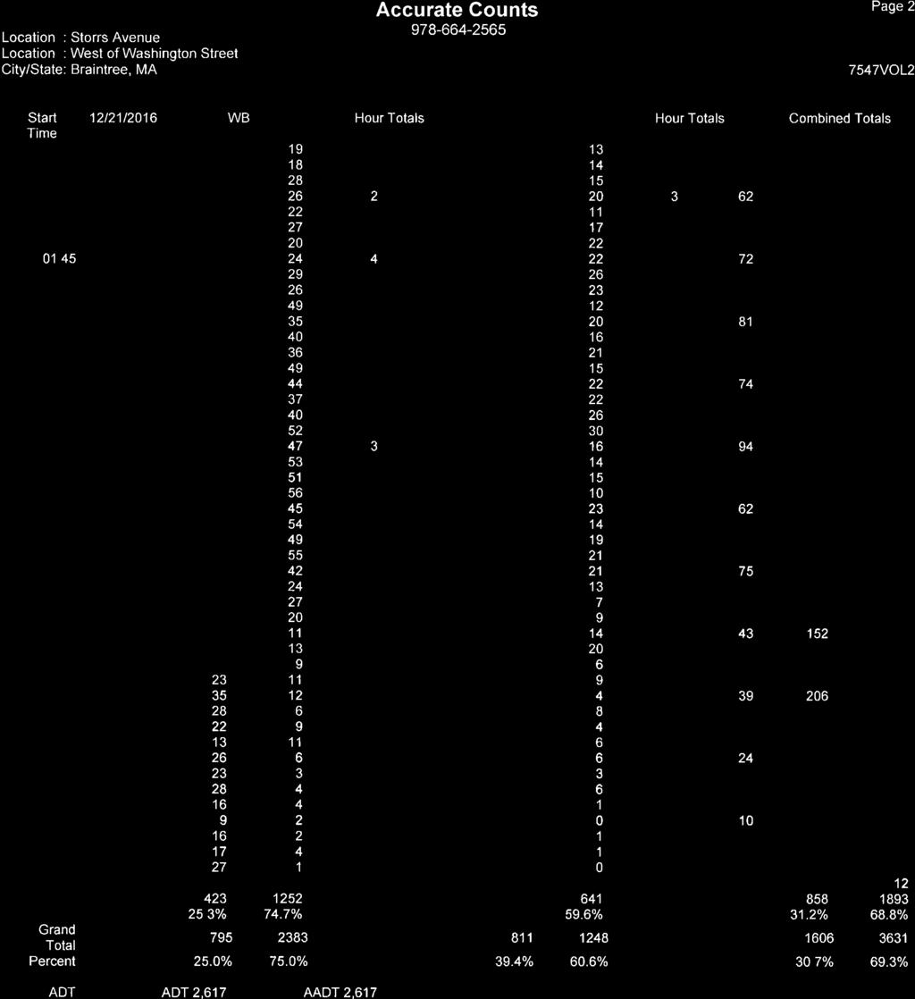
56
57
58
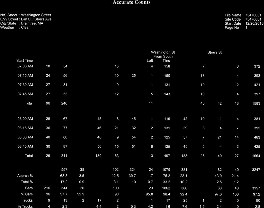
59
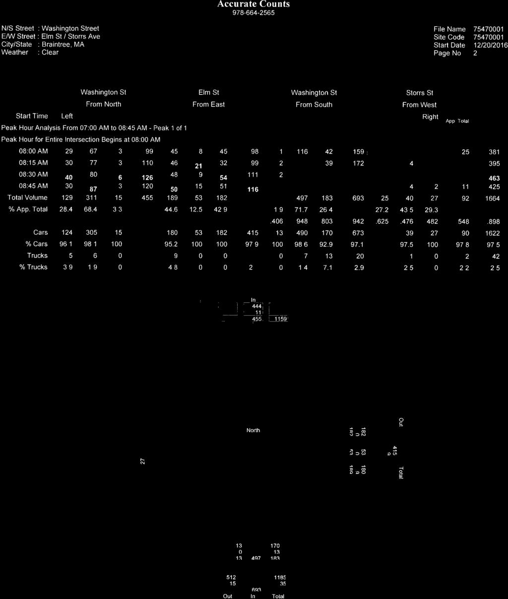
60
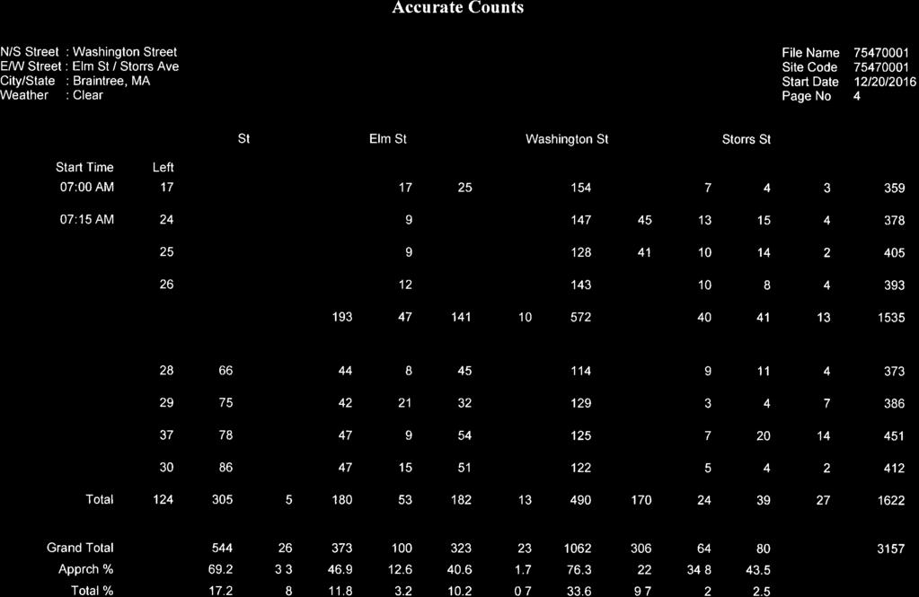
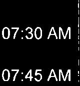
61
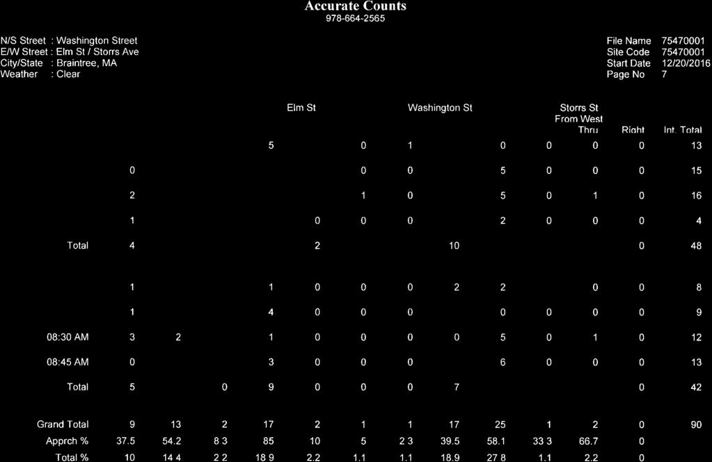
62
63
64
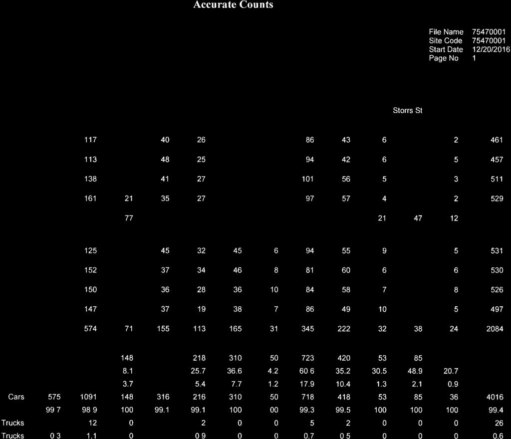
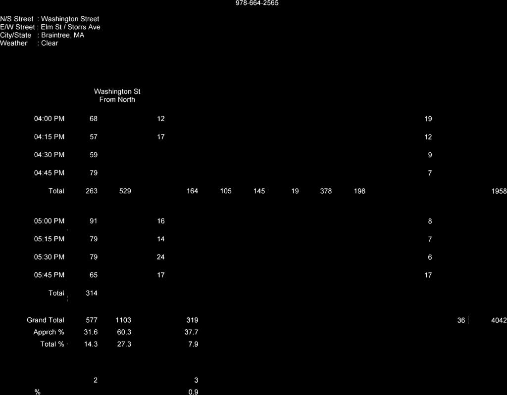
65
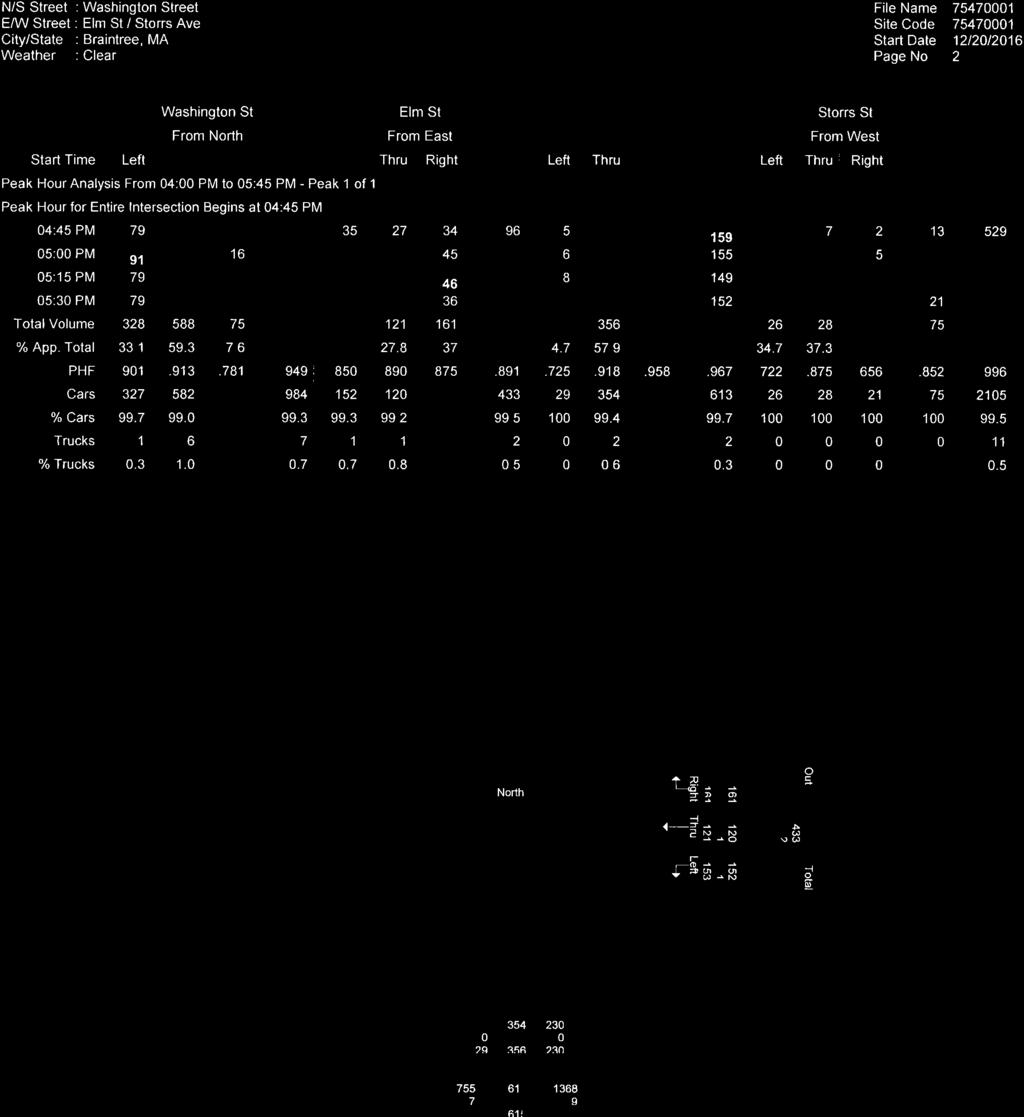
66
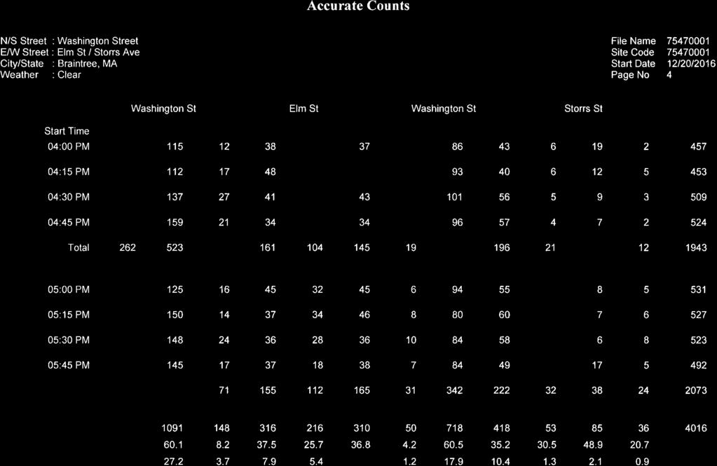
67
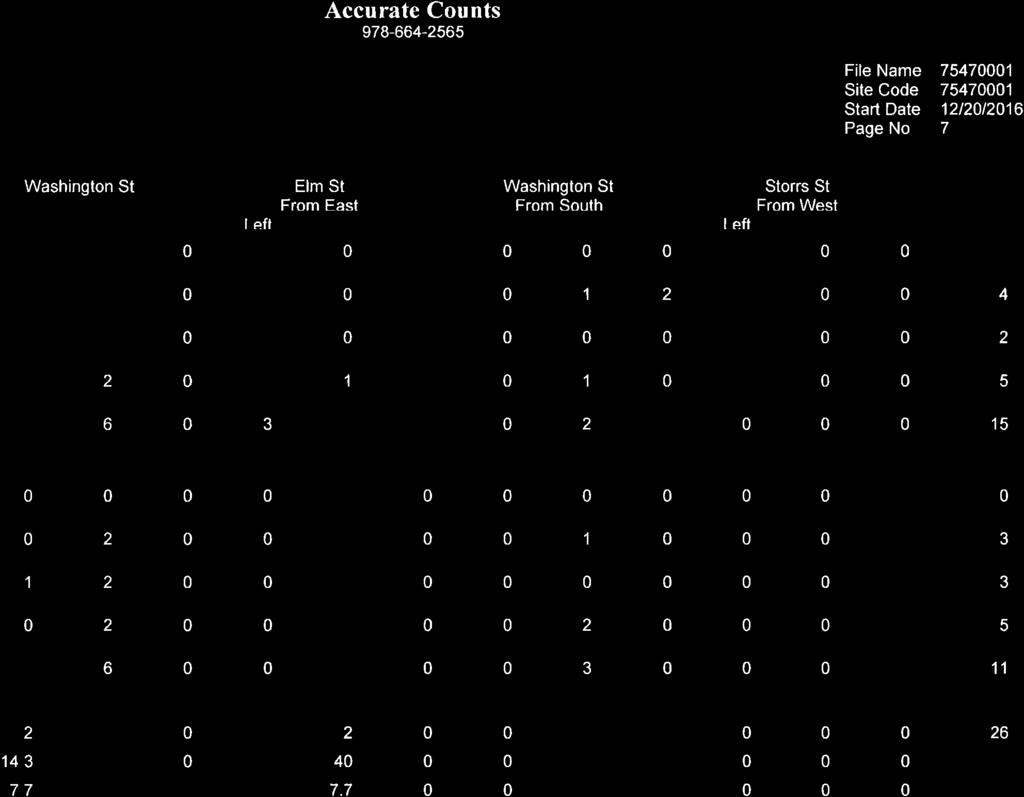
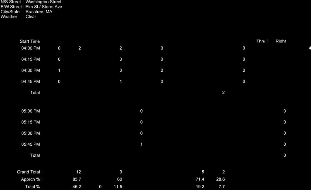
68
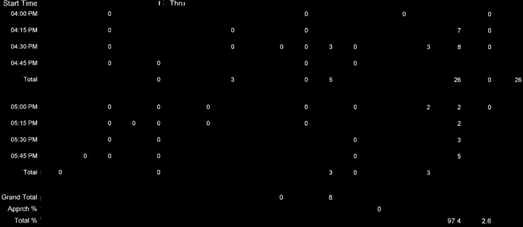
69
70
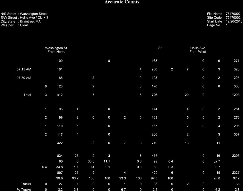
71
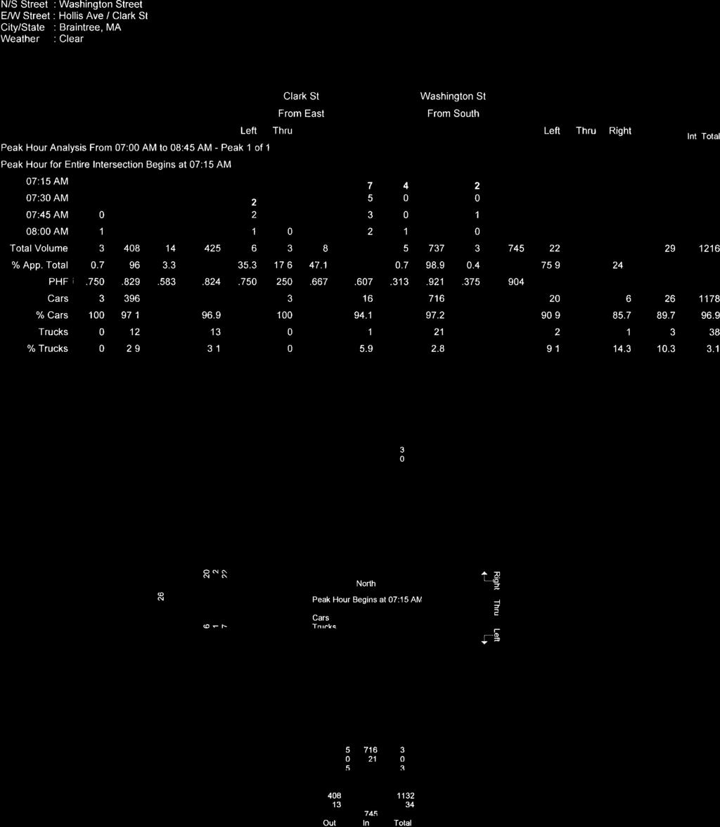
72
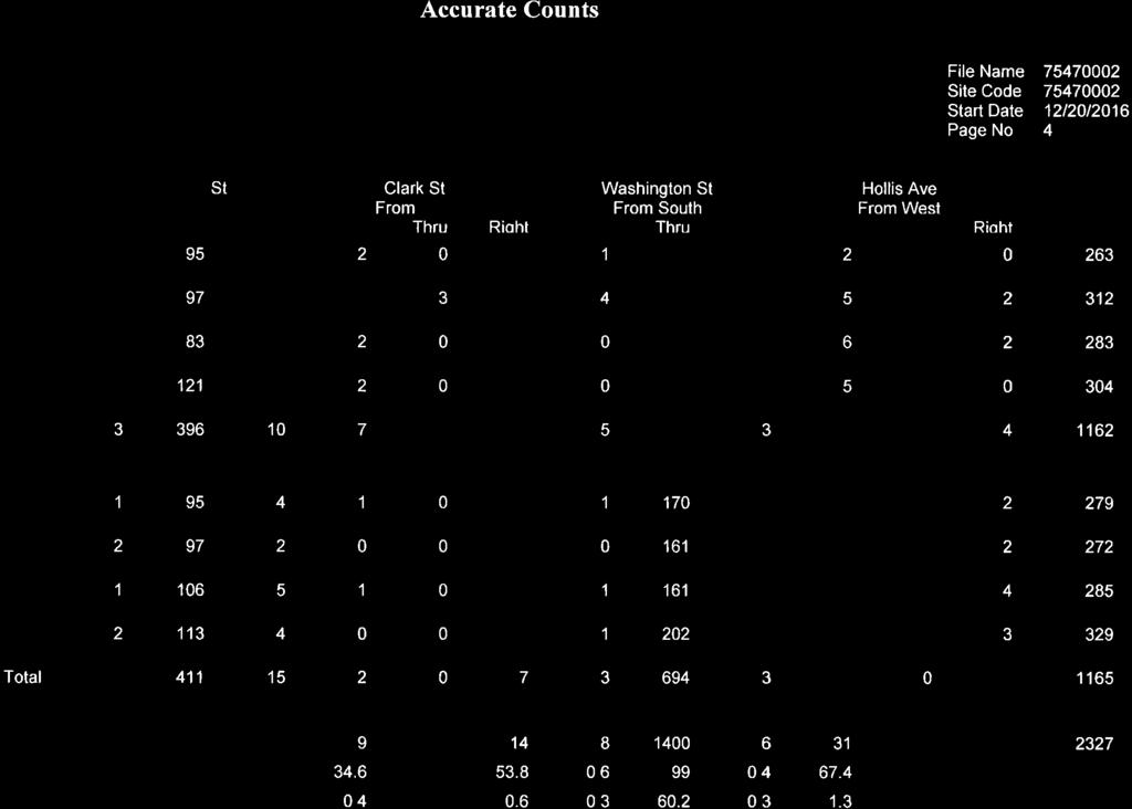
73
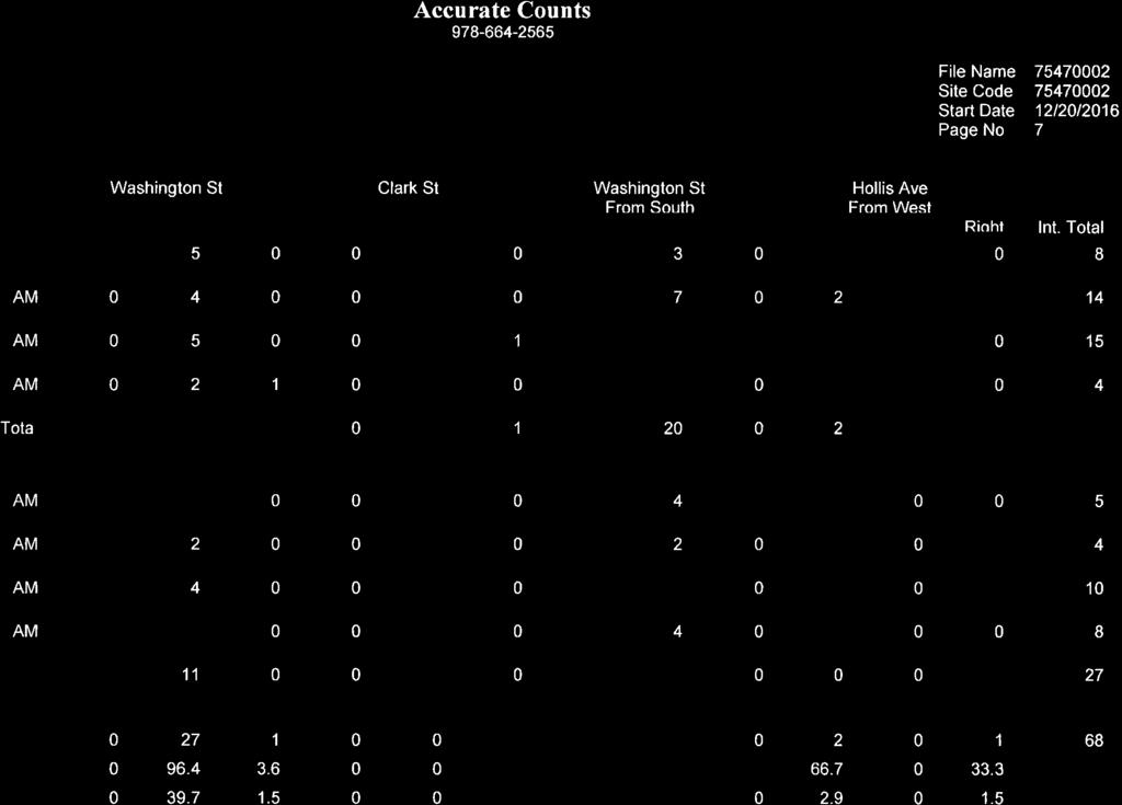
74
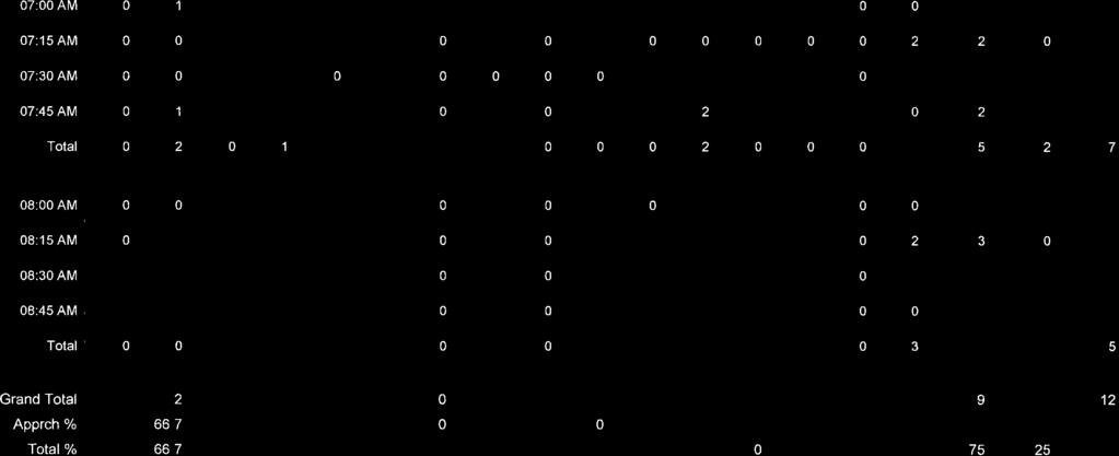
75
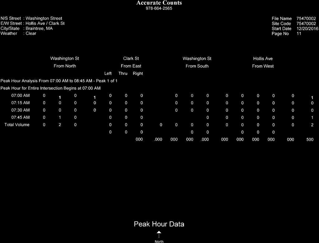
76
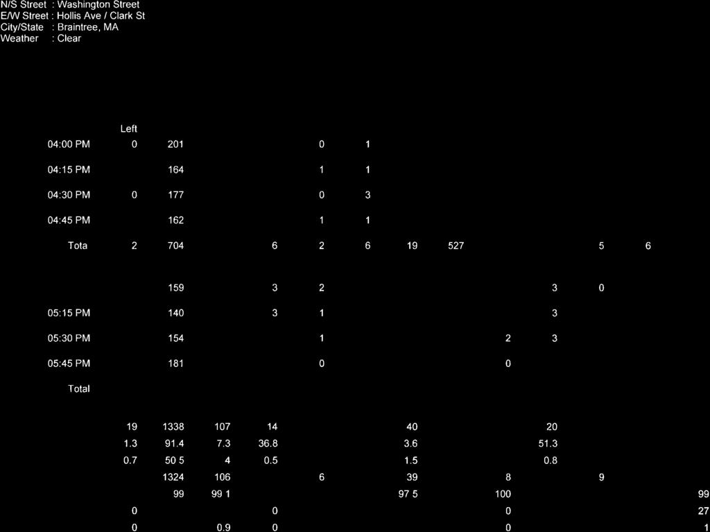
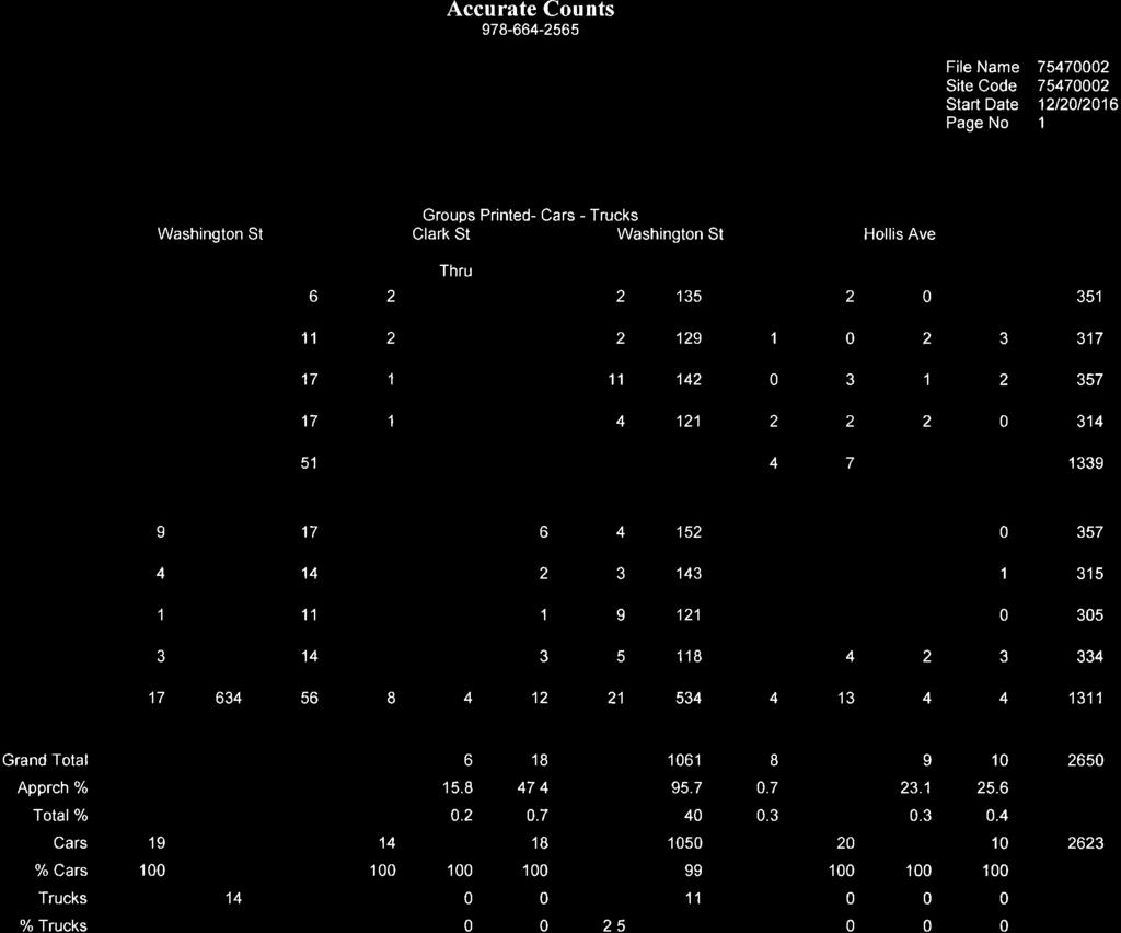
77
78
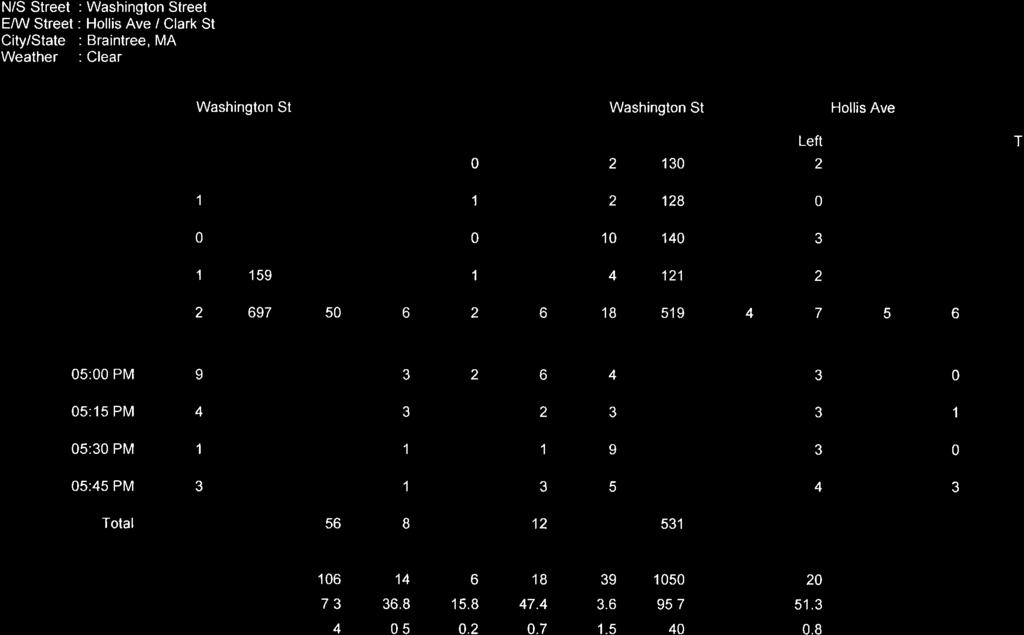
79
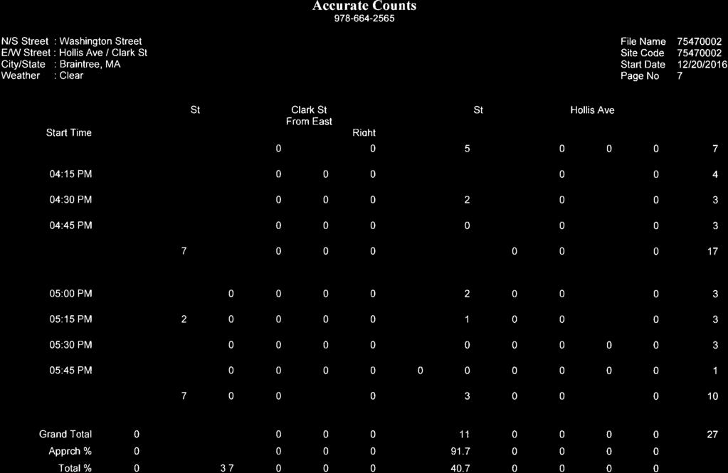
80
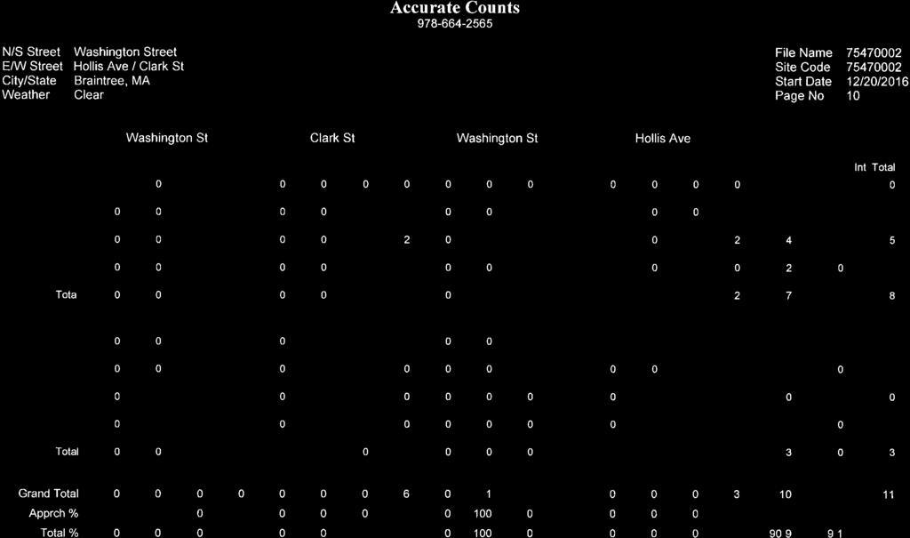

81
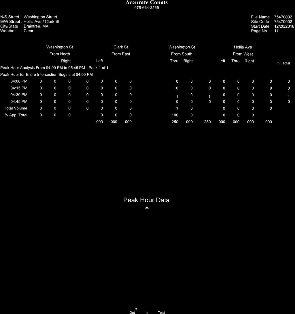
82
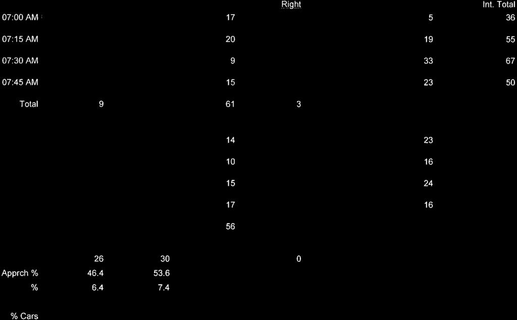
83

84
85
86
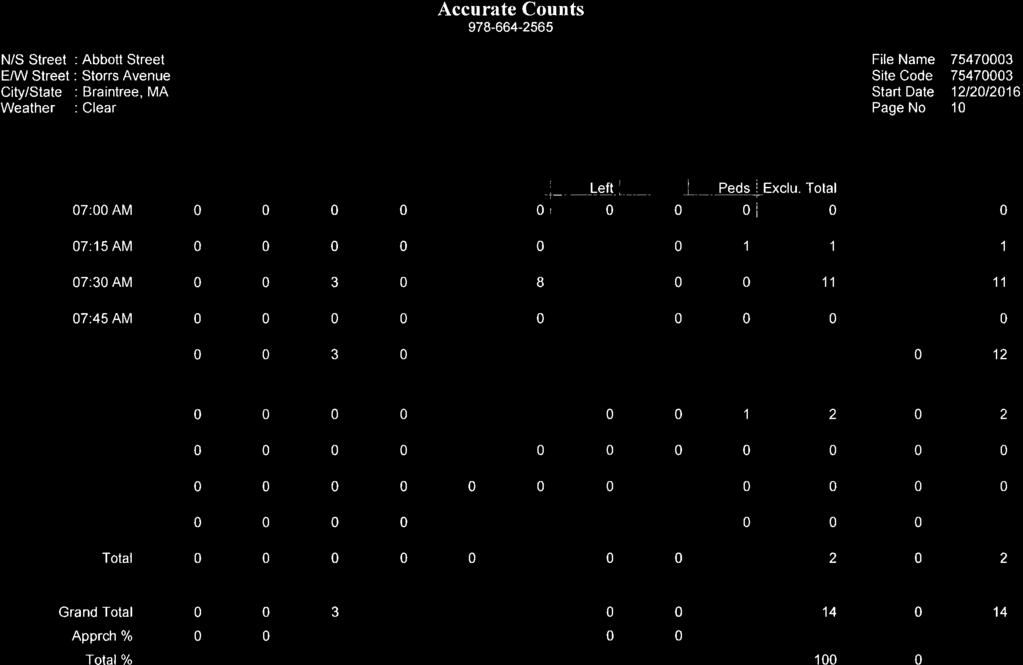

87
88
89
90
91
92
93
94
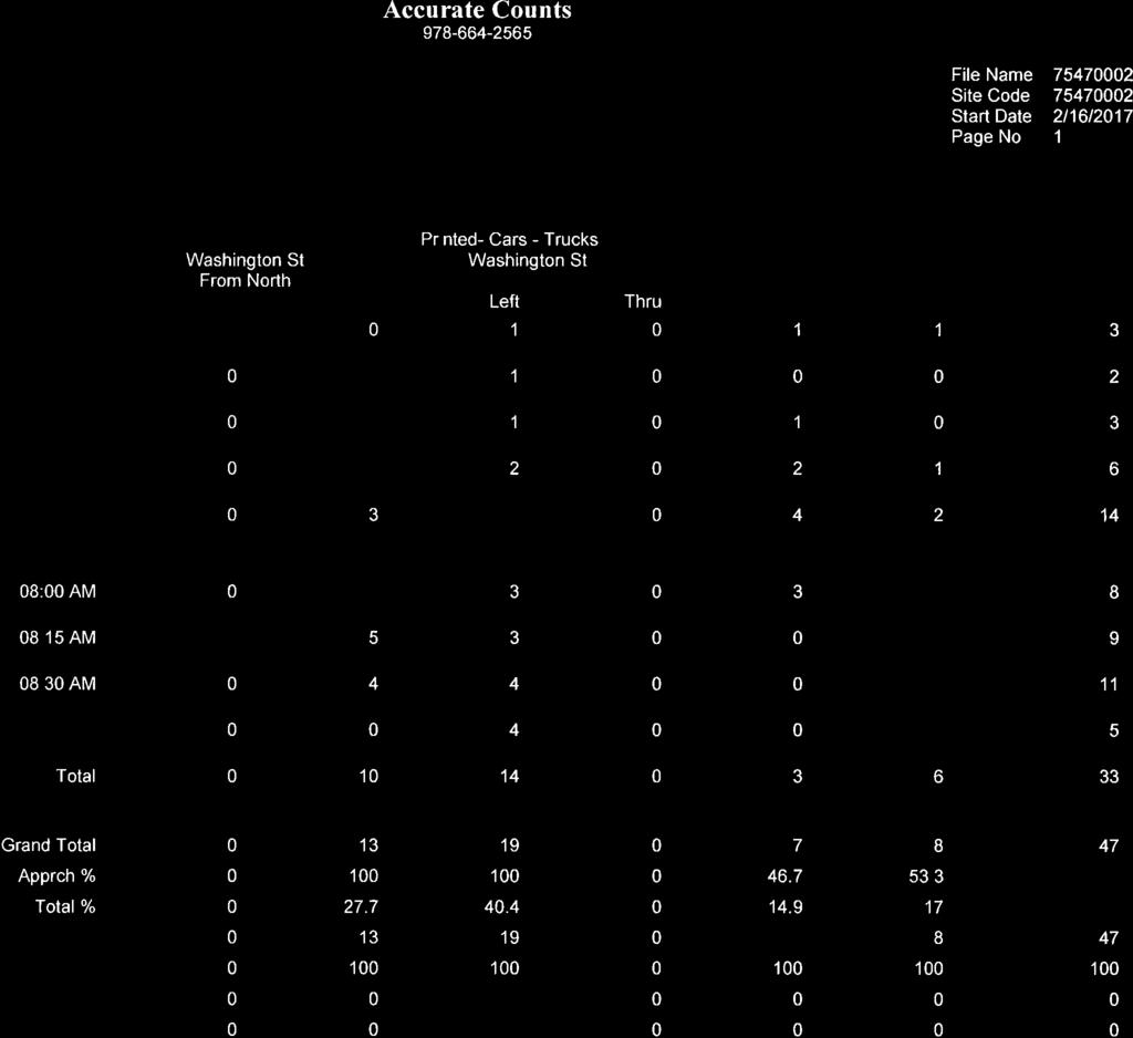

95
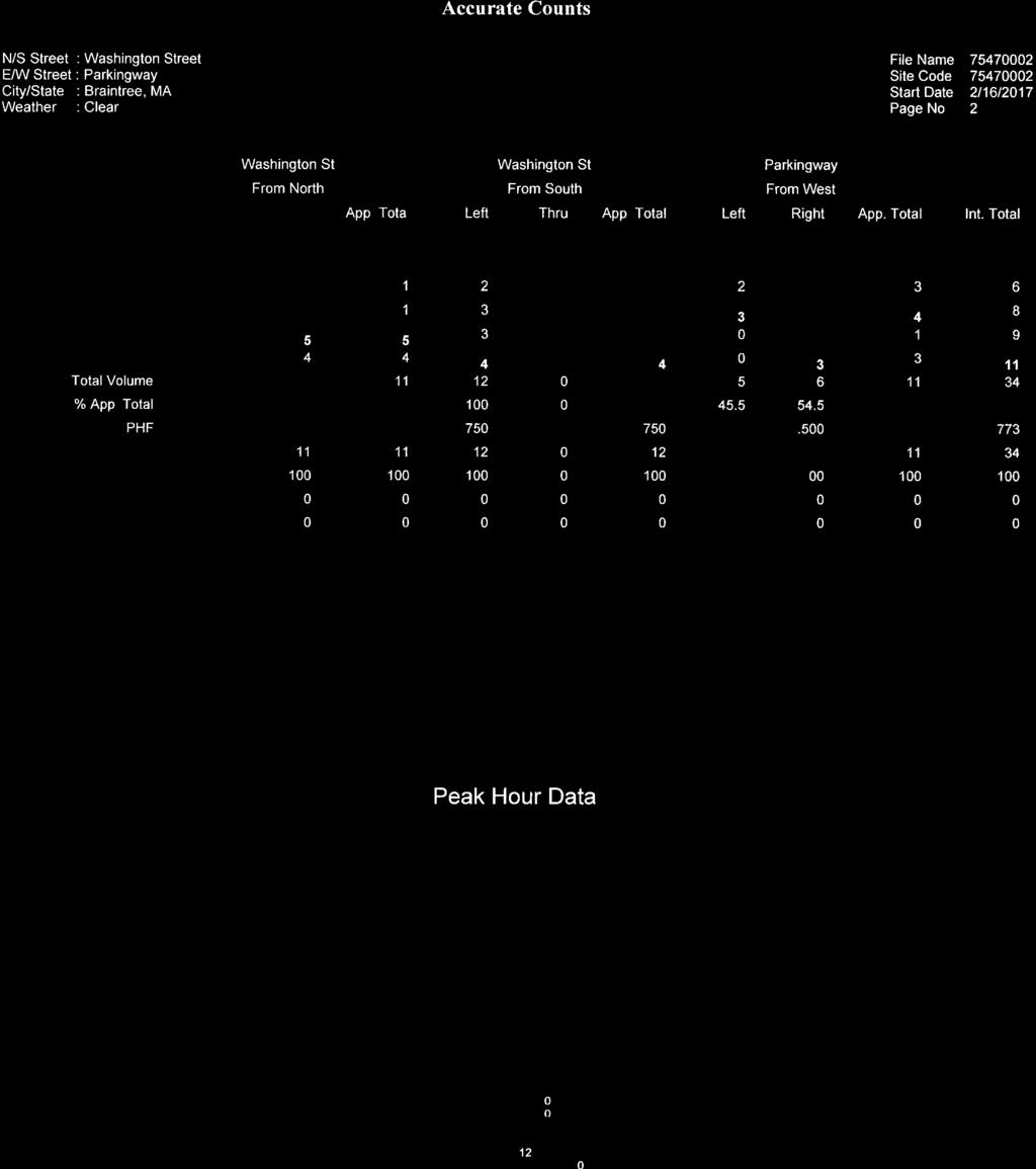
96
97
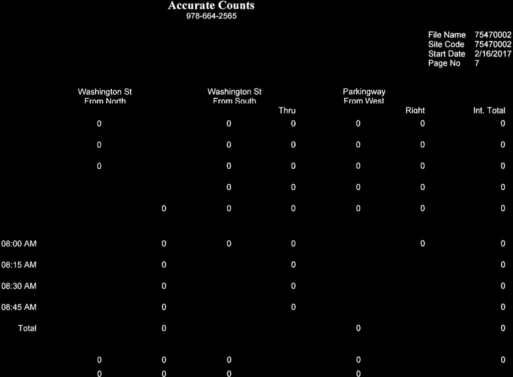
98
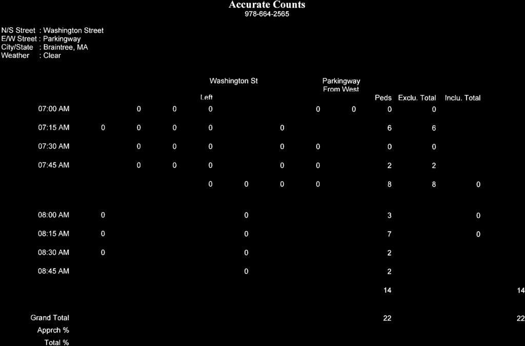
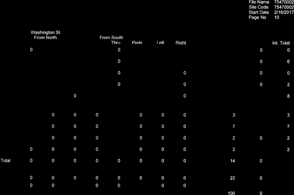
99
100
101

102
103
104
105
106
107

108
109
110
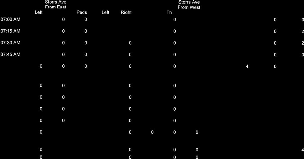
111
112
113
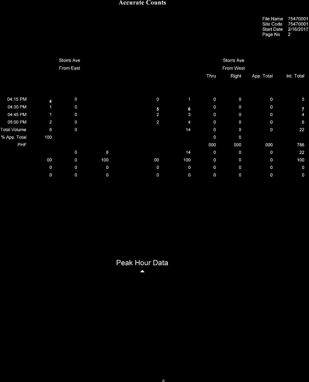
114
115
116
117
118
119

120
121
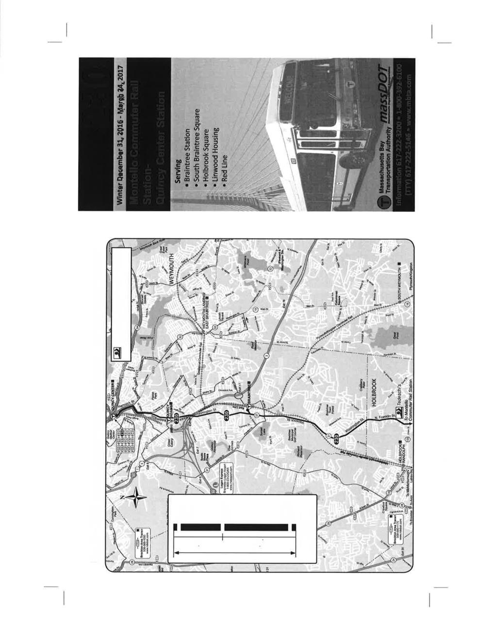
122
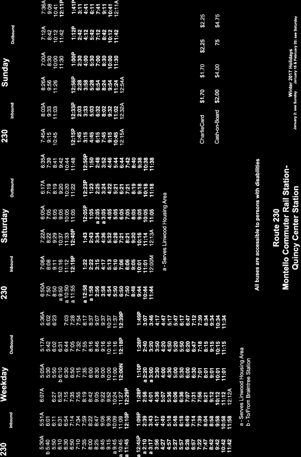
123
124
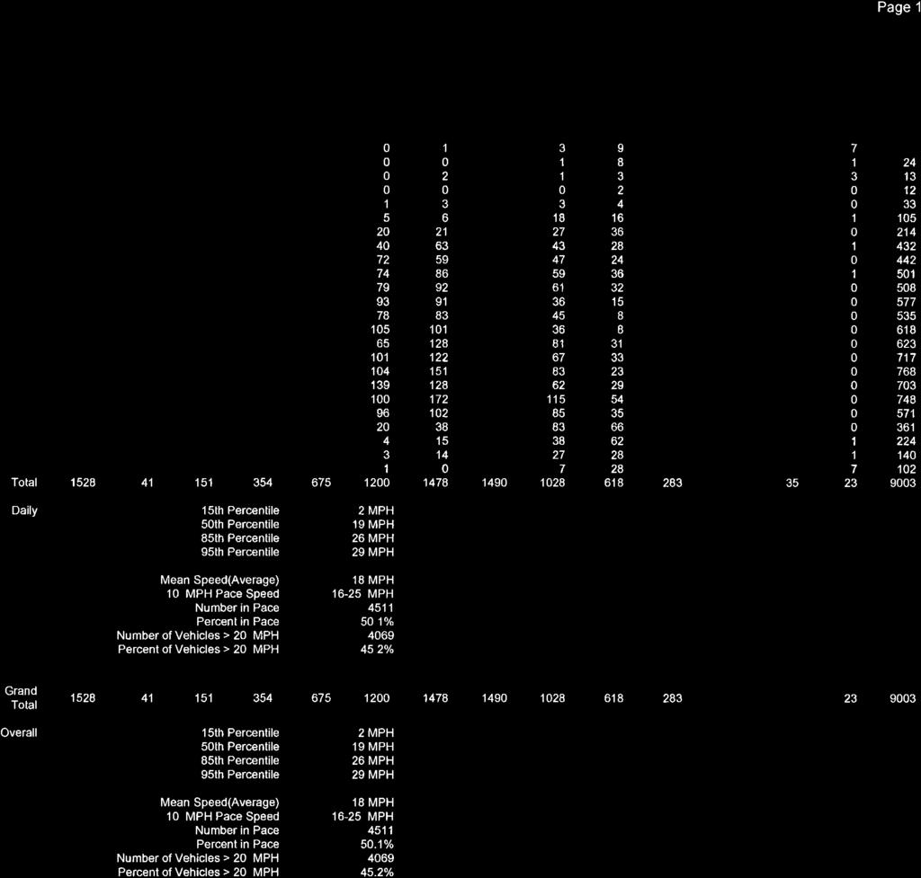
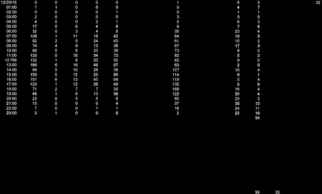
125
126
127
128
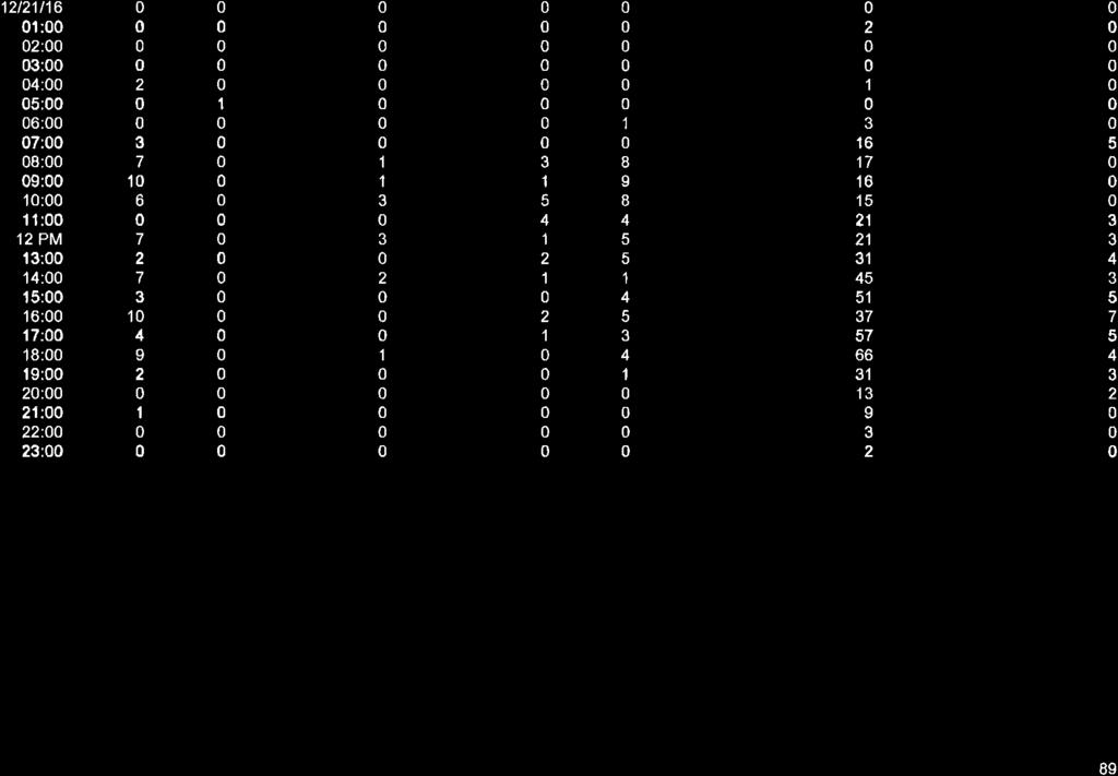
129
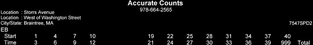

130
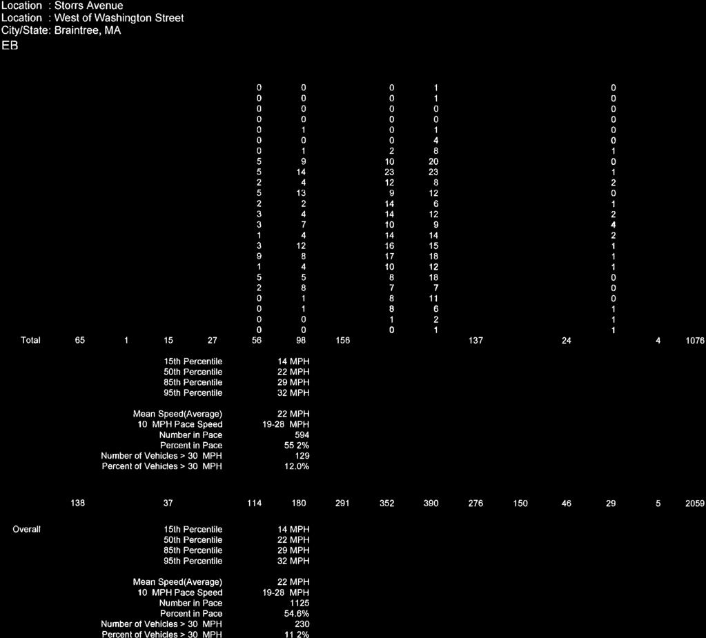
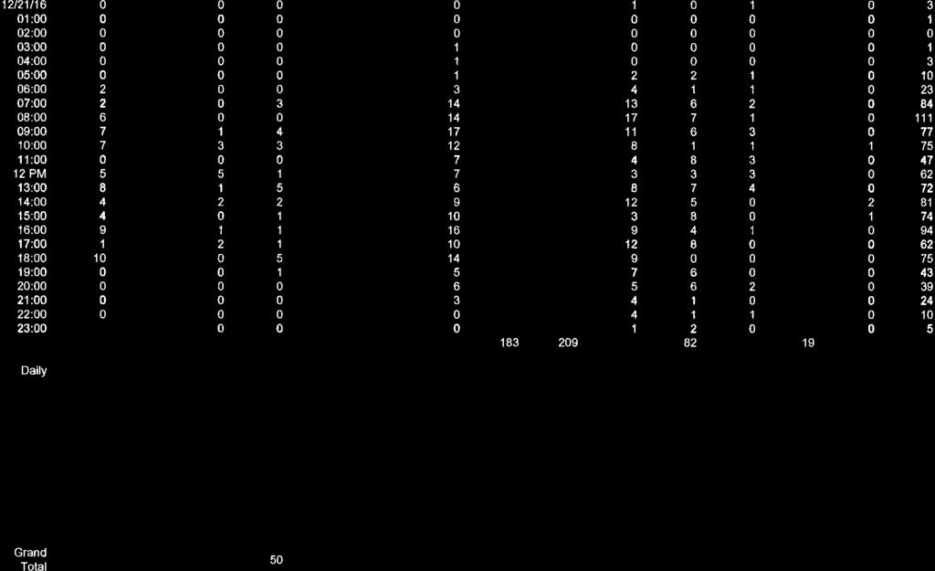
131
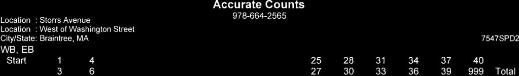
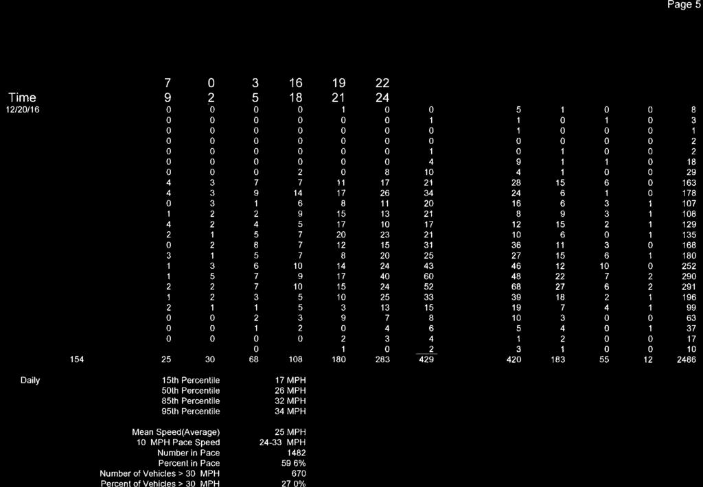
132
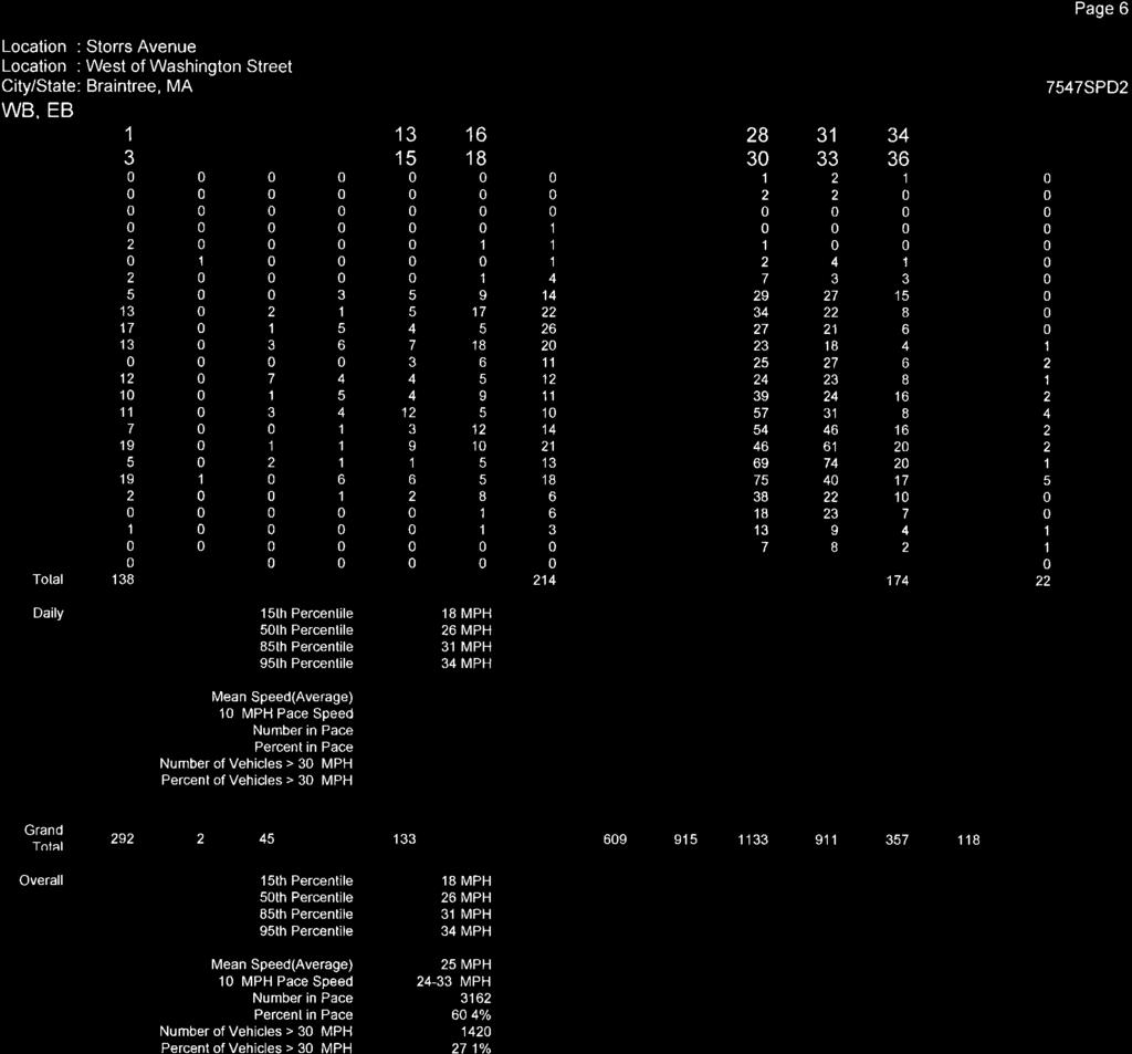
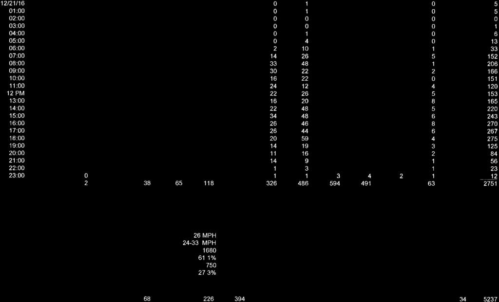
133
134
135
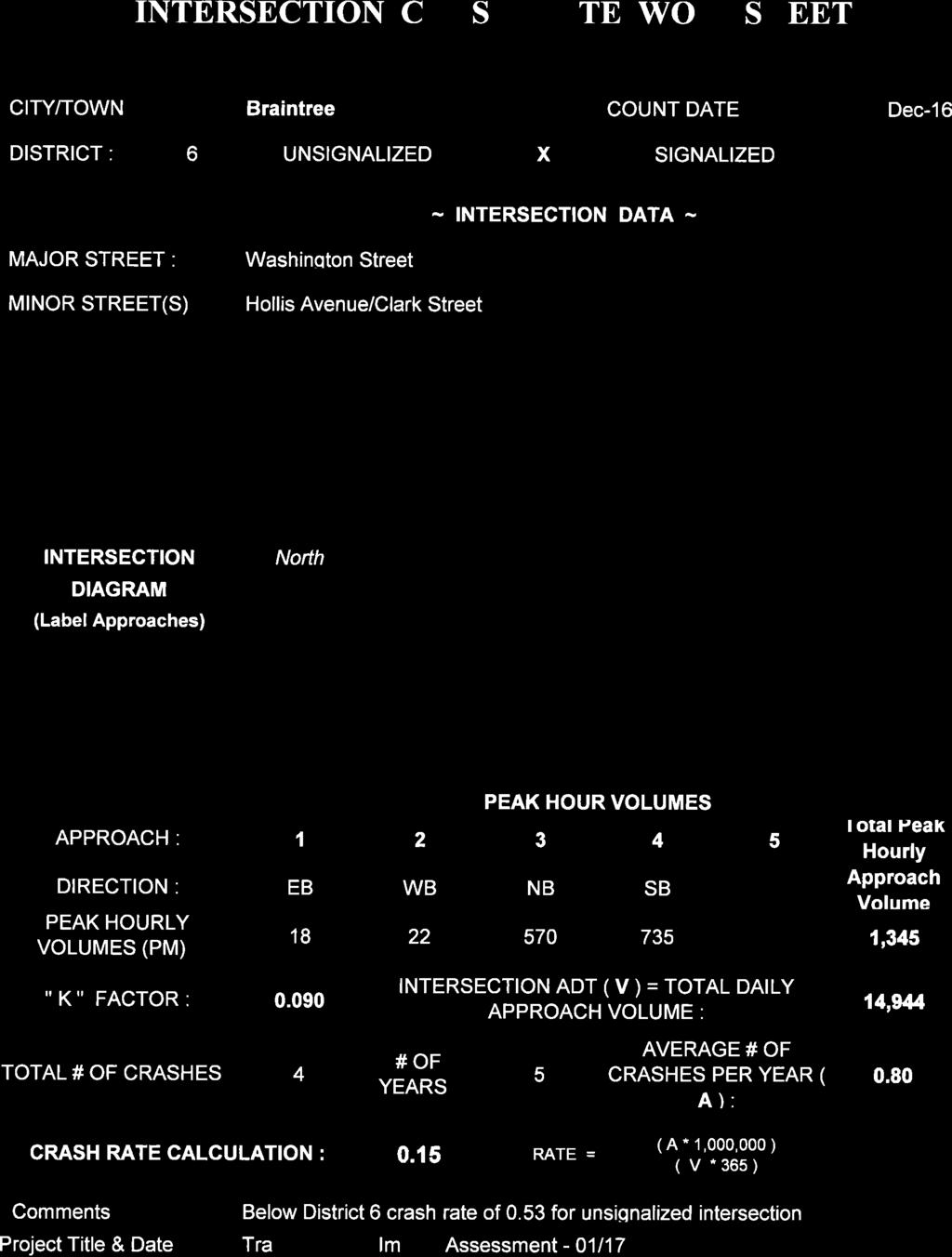
136
137
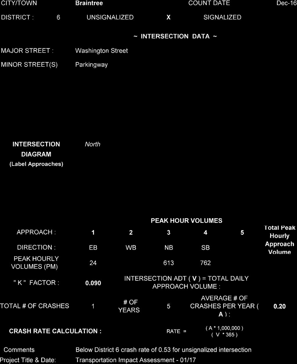
138
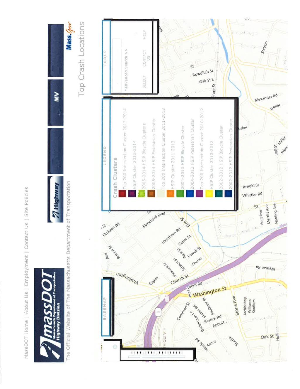
139
140
141
142
143
144
145
146
147
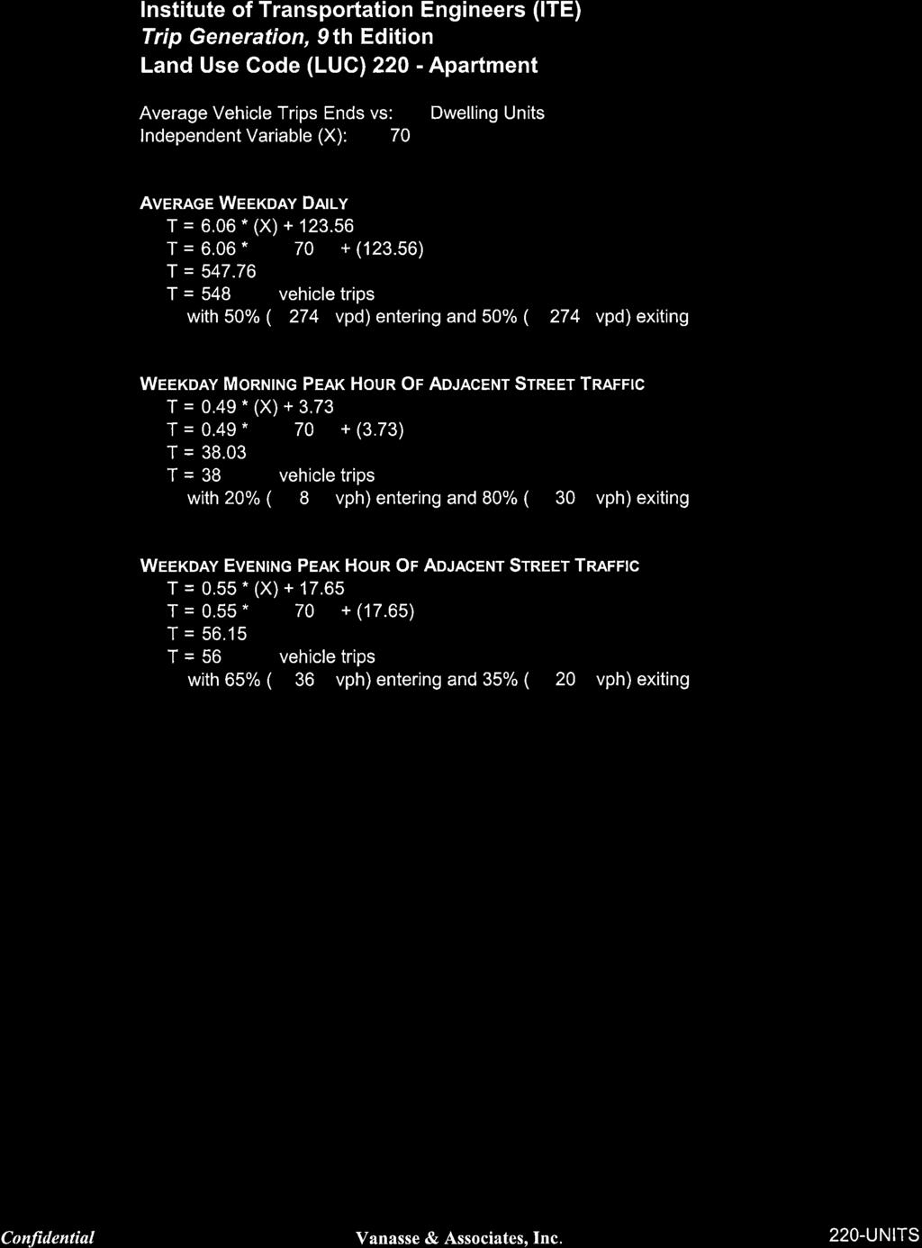
148
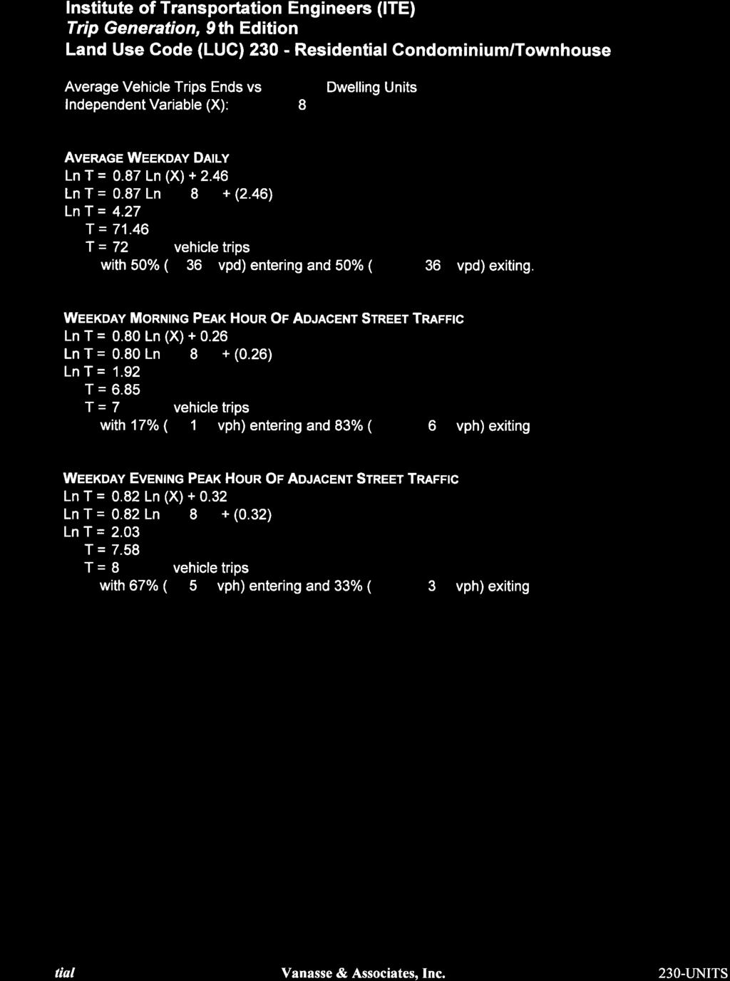
149
150
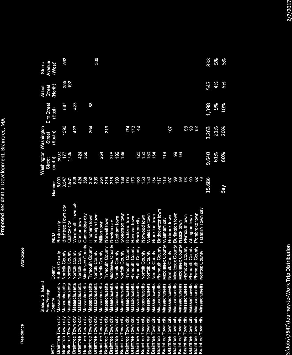
151
152
153
154
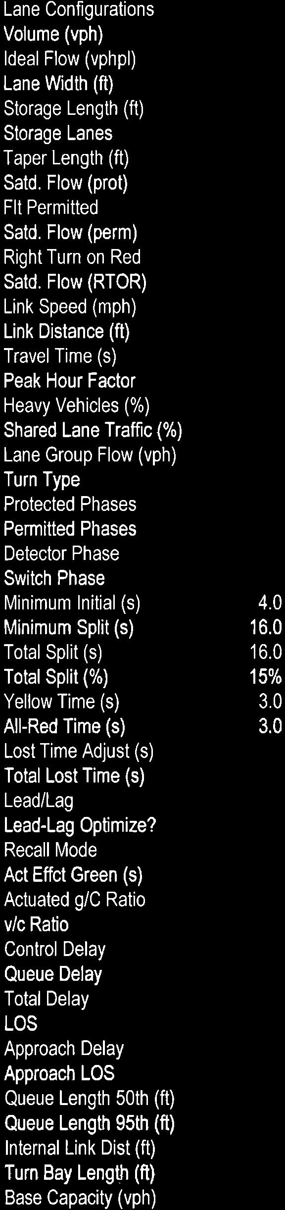
155
156
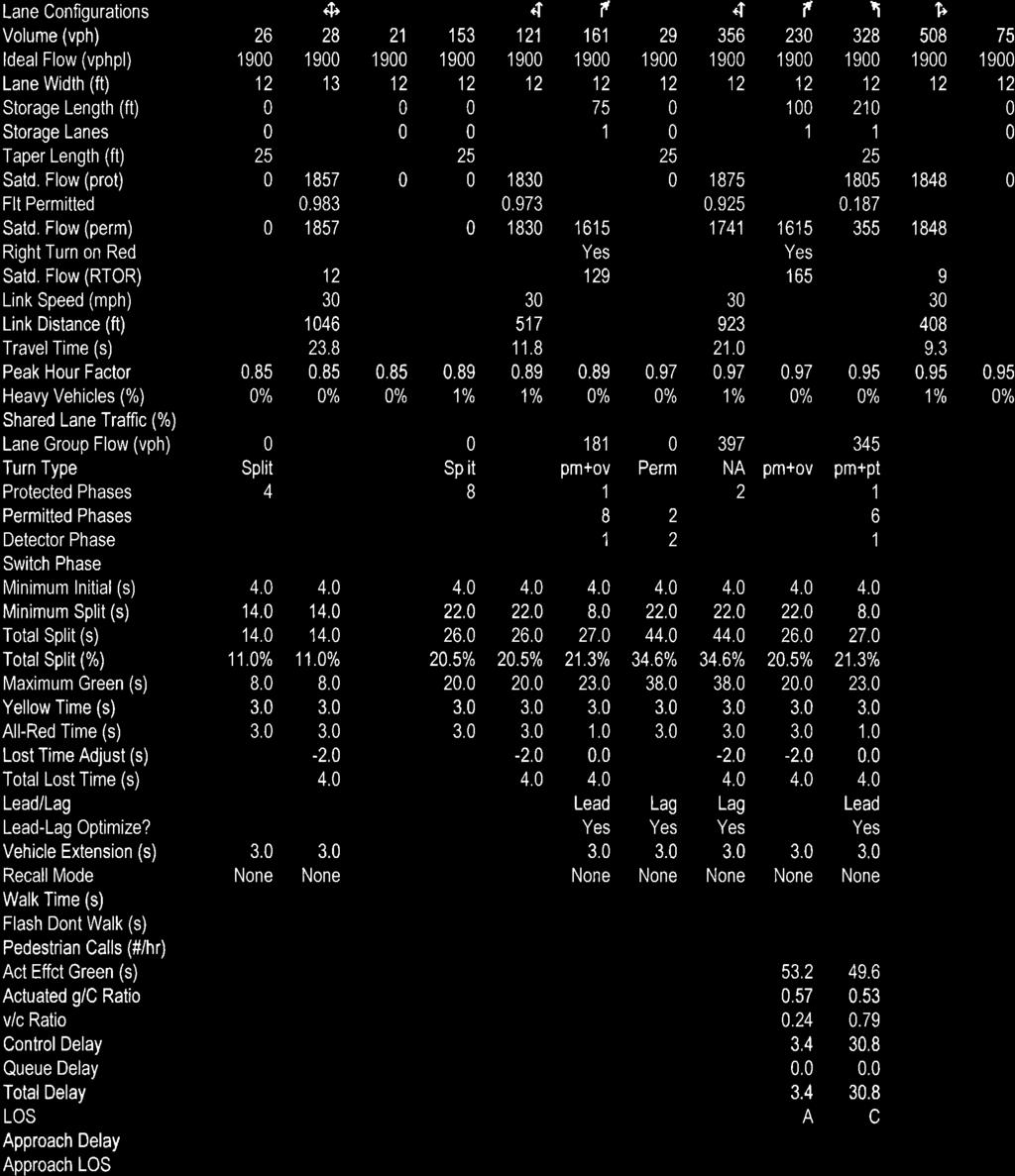
157
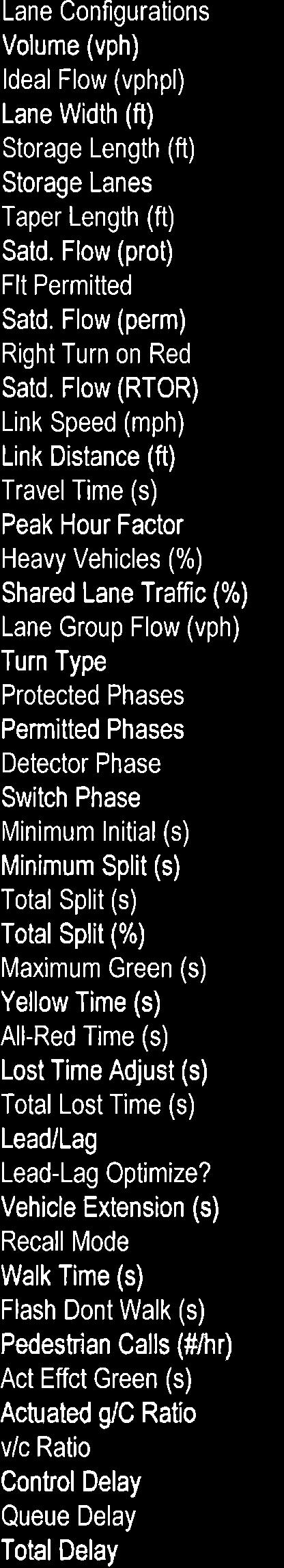
158
159
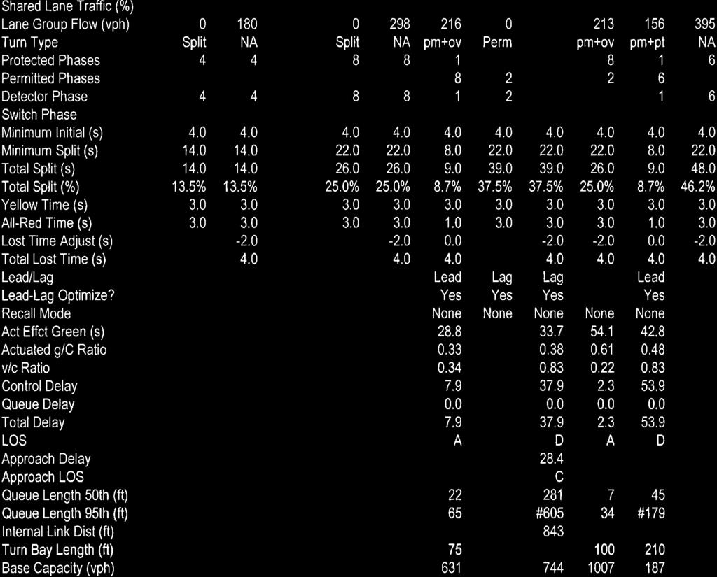
160
161
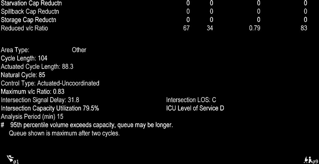
162
163
164
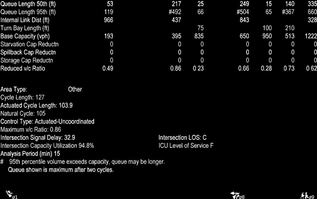
165
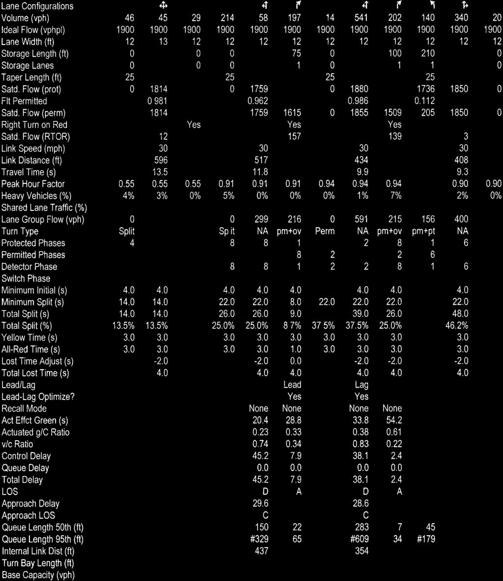
166
167
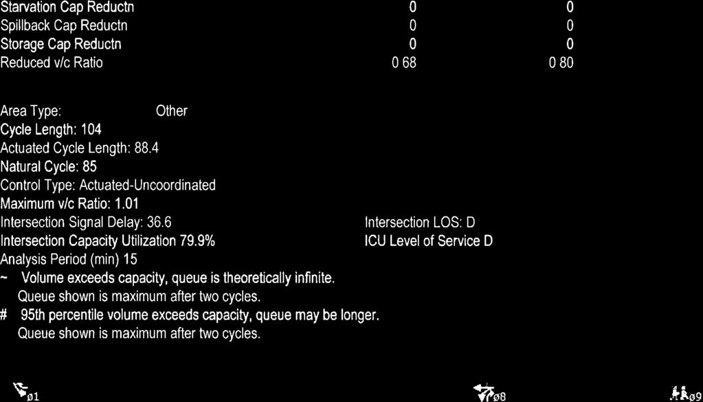
168
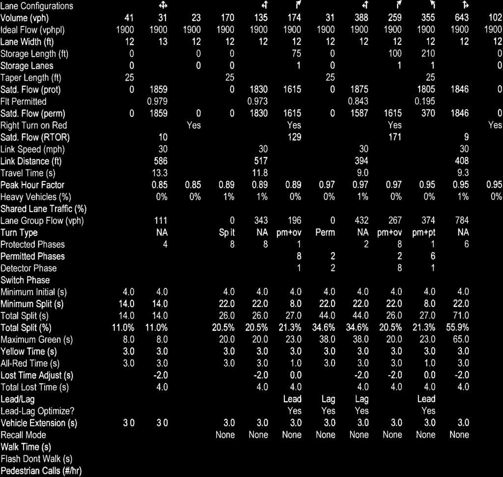
169
170
171
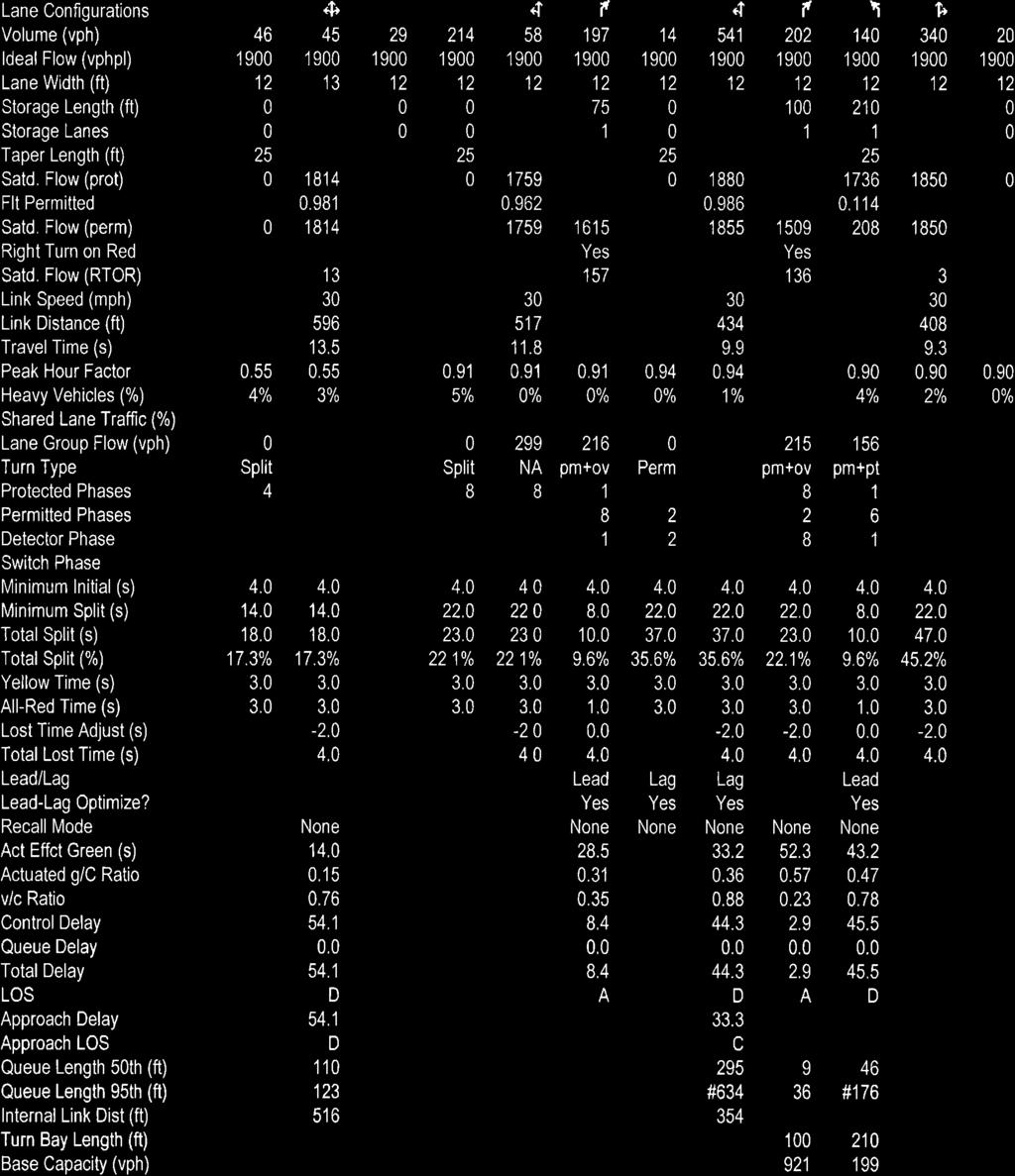
172
173
174
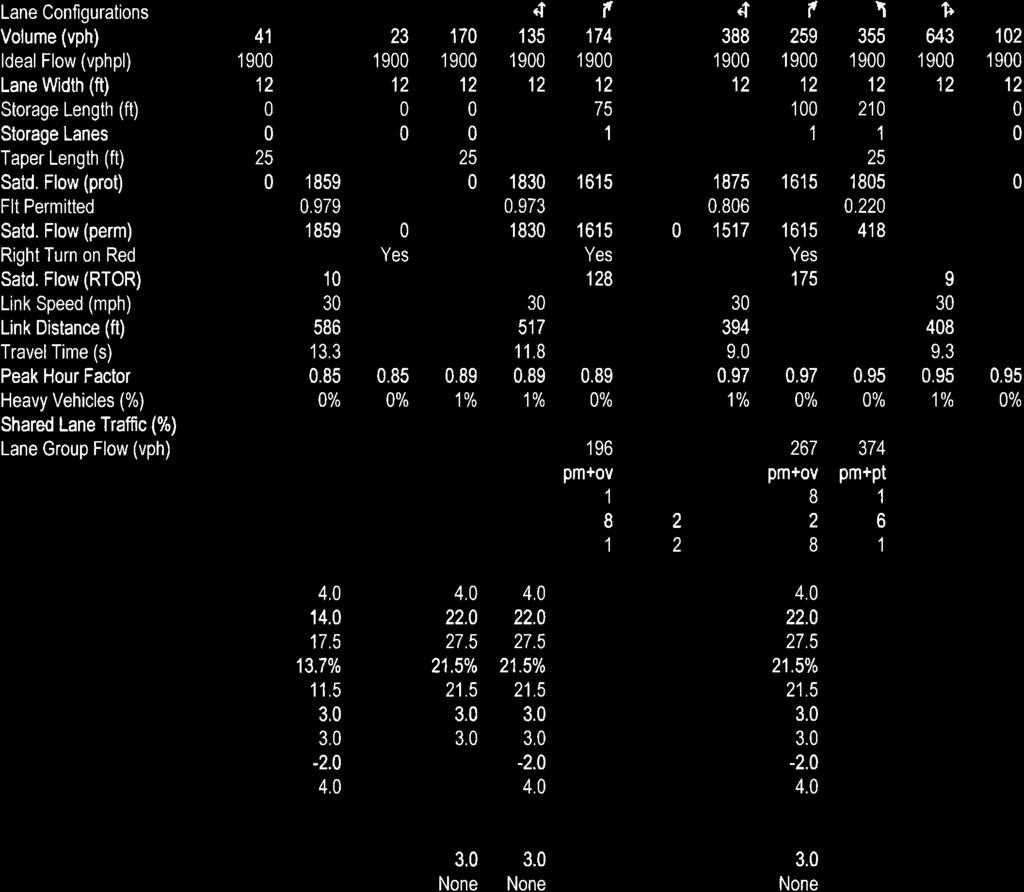
175
176
177
178
179
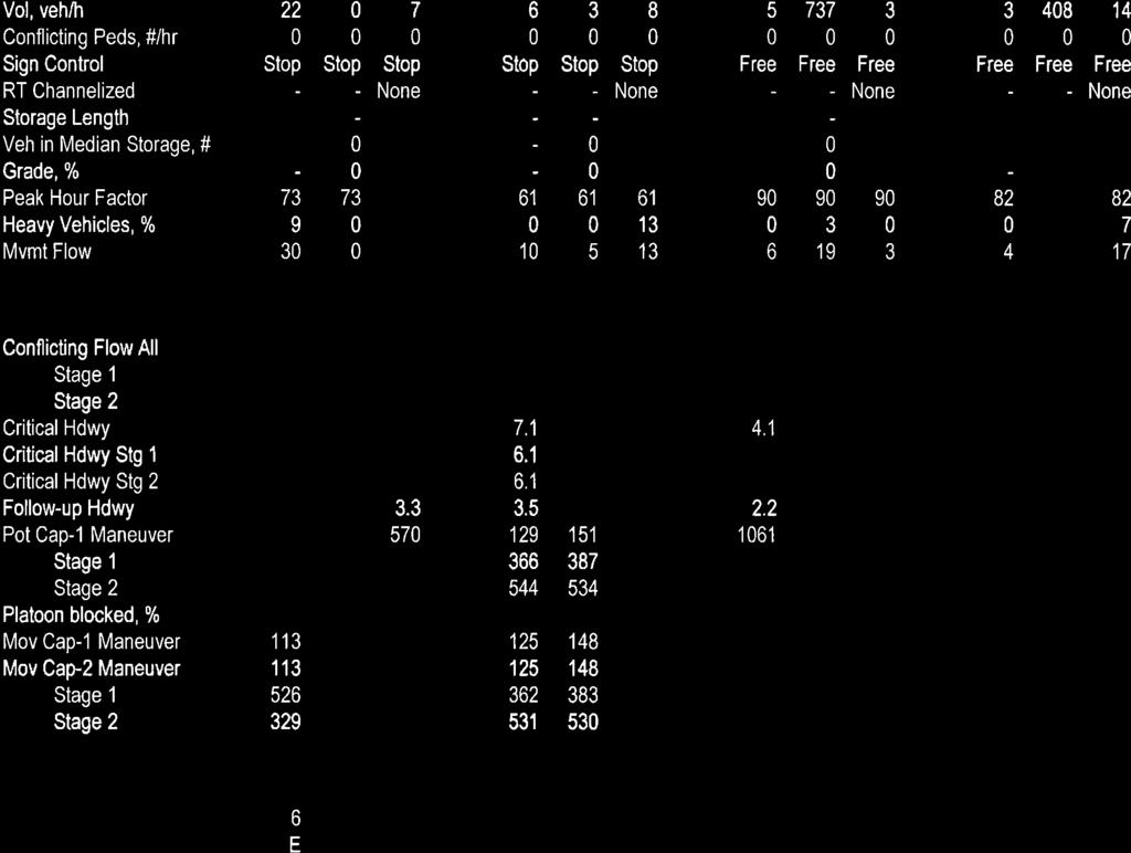
180
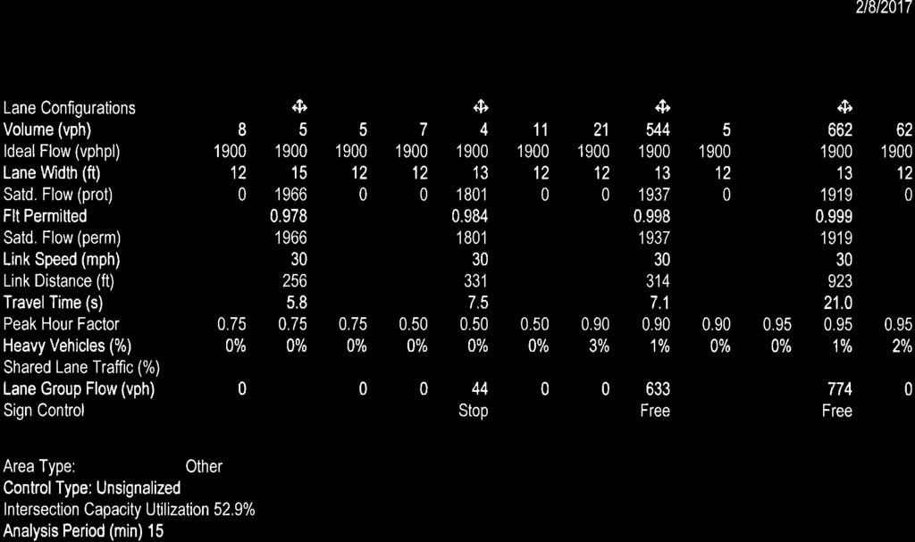
181
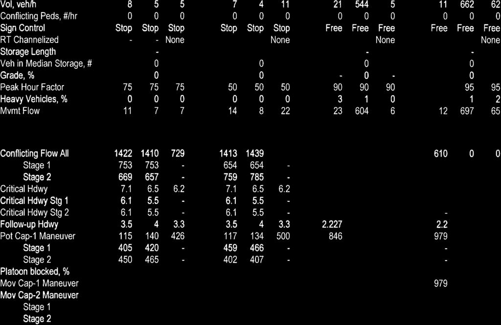
182
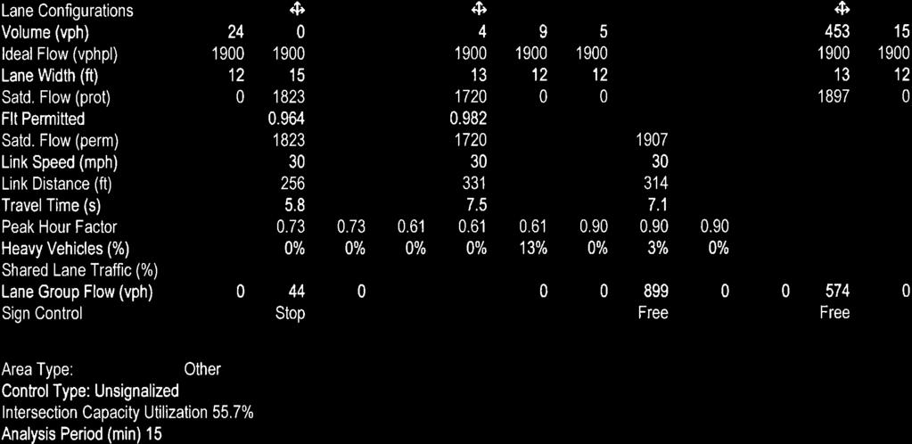
183
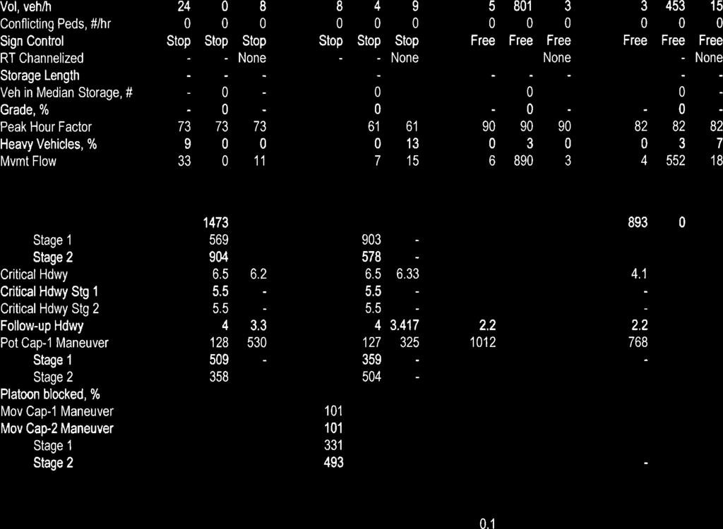
184
185
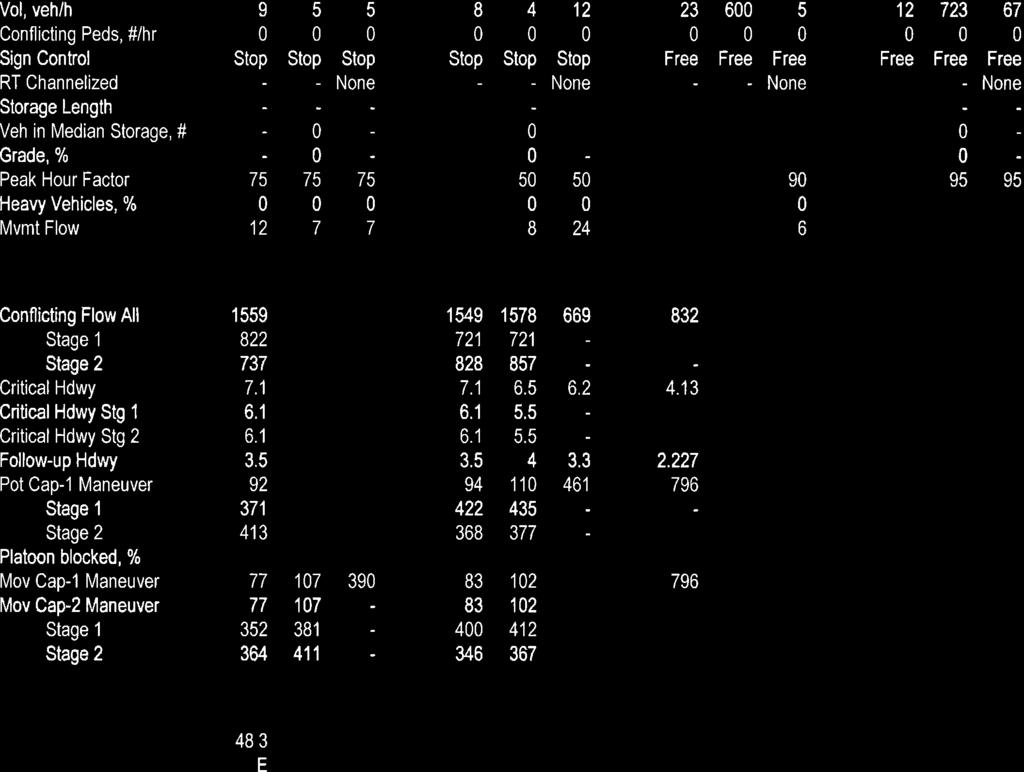
186
187
188
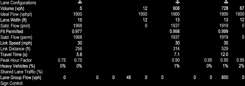
189
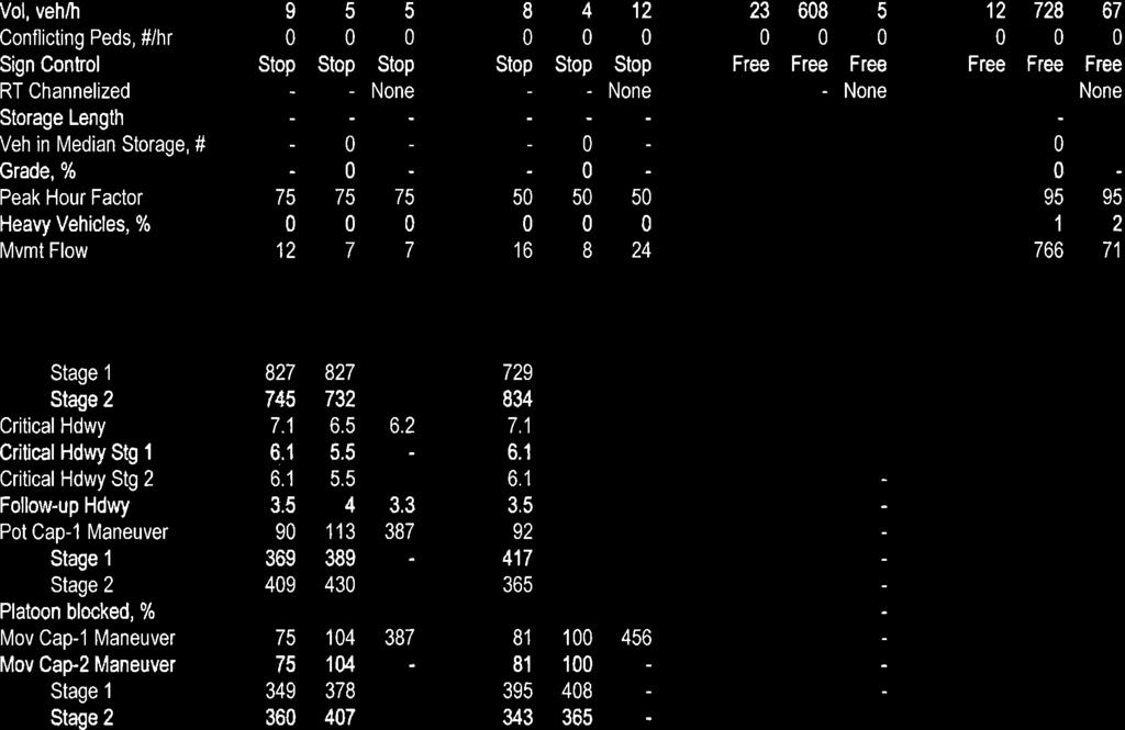
190
191
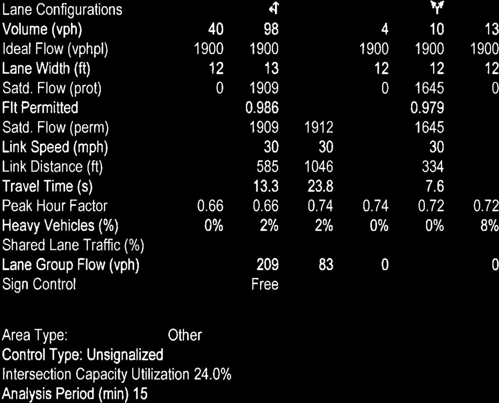
192
193
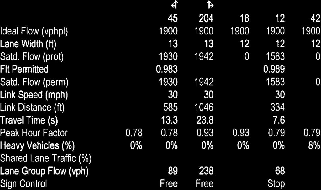
194
195
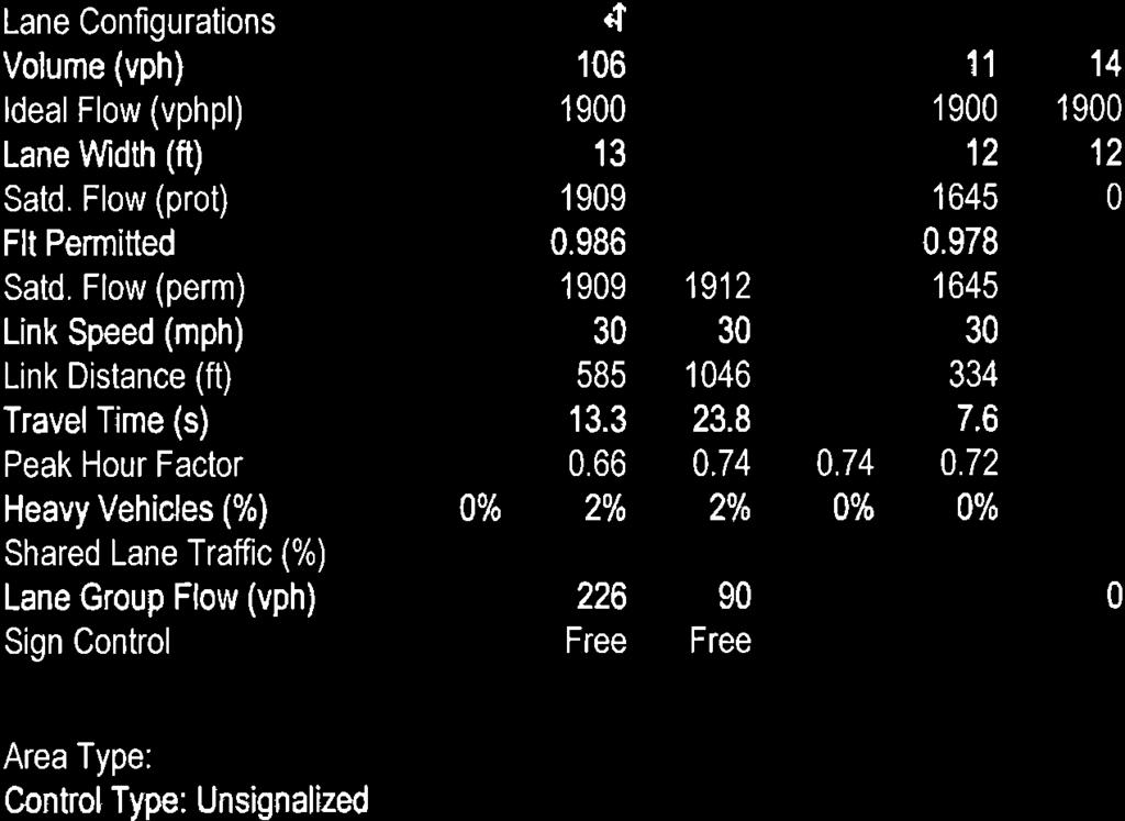
196
197

198
199
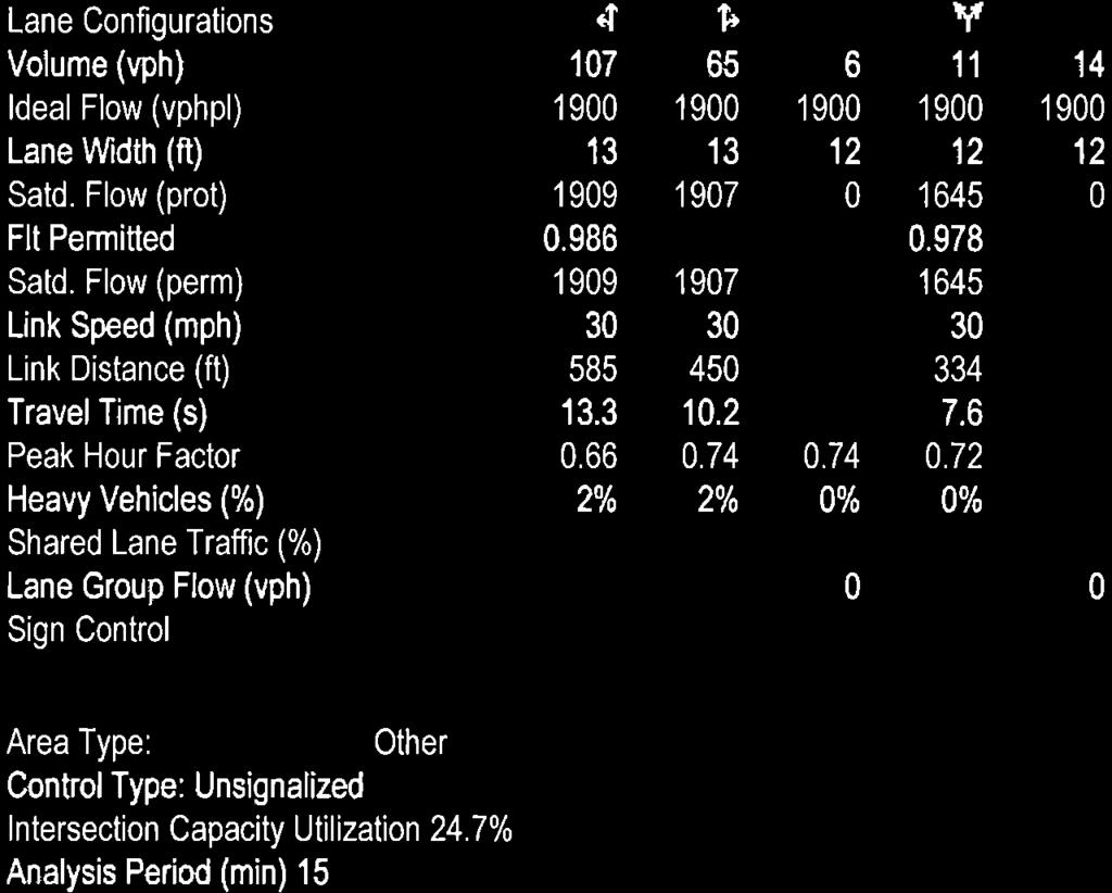
200
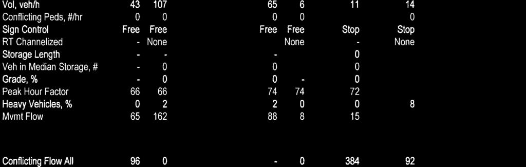
201
202
203
204
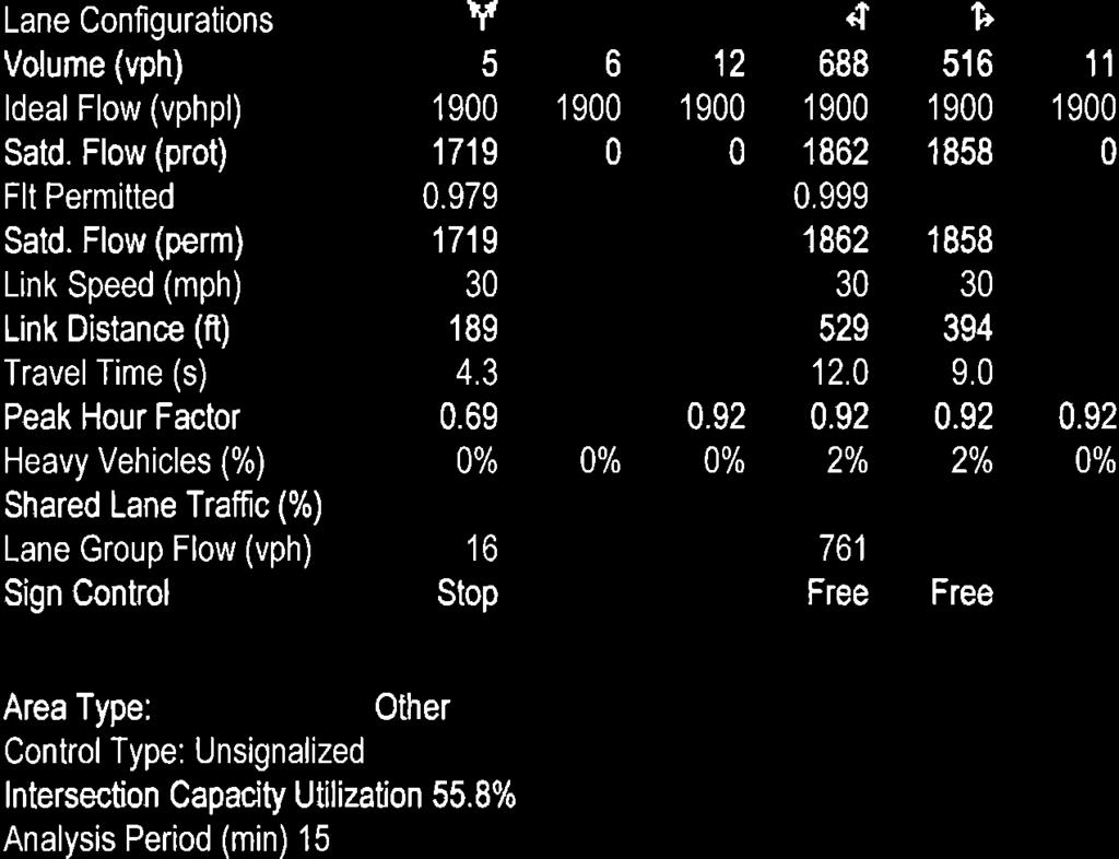
205
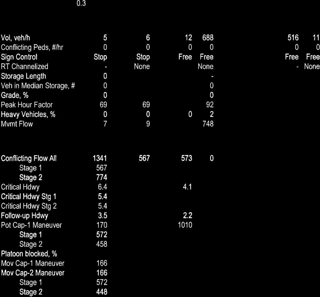
206
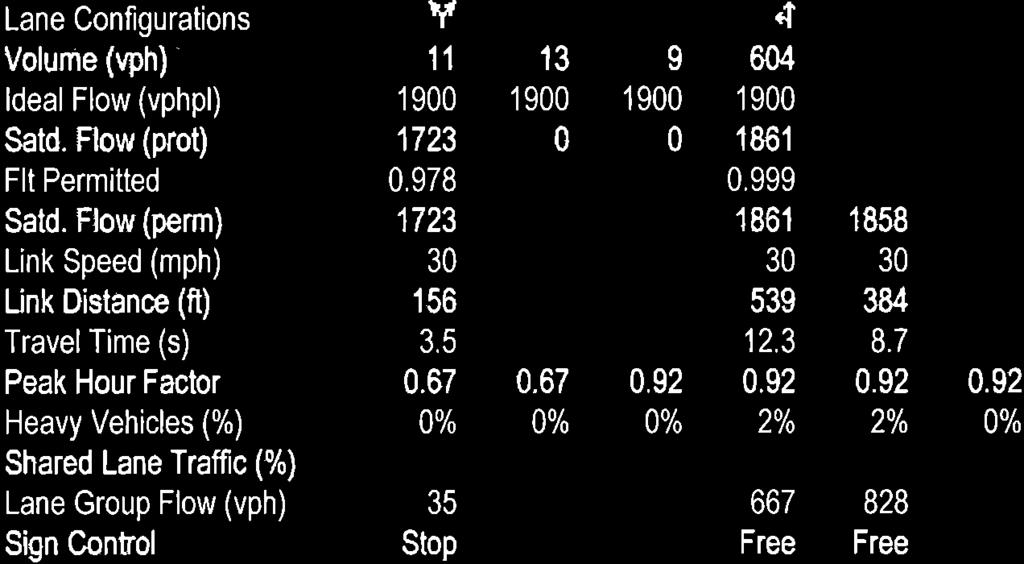
207
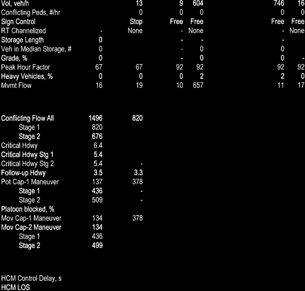
208
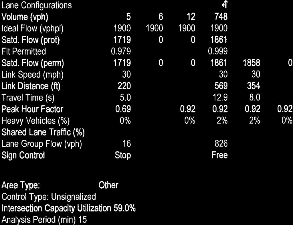
209
210
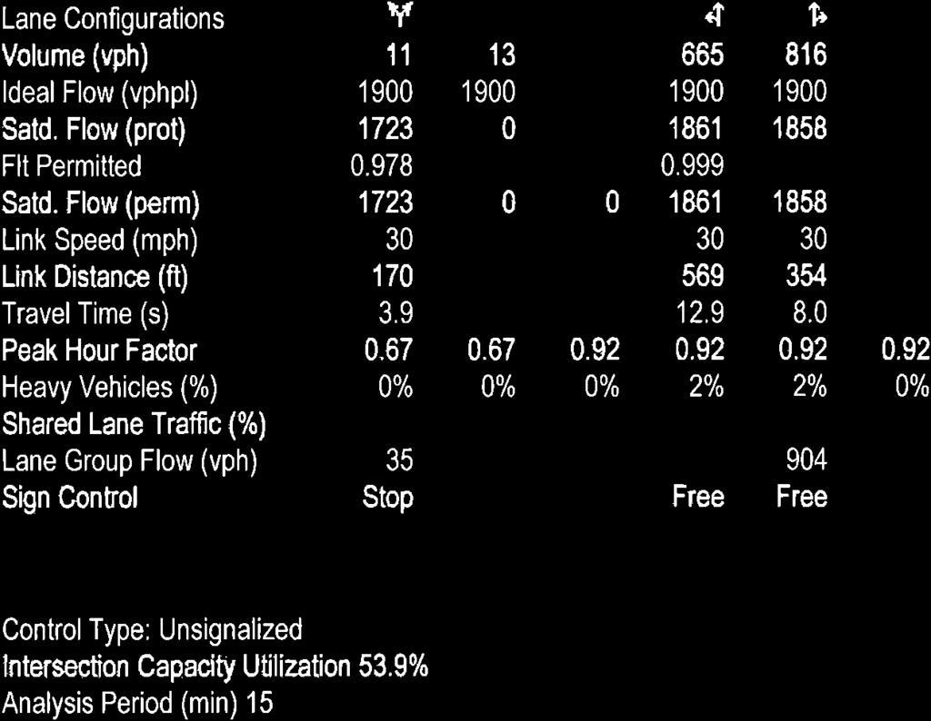
211
212
213
214
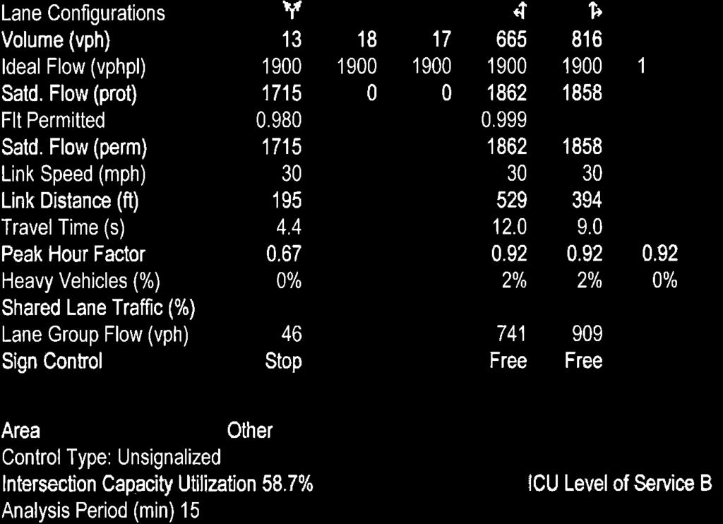
215
216
217
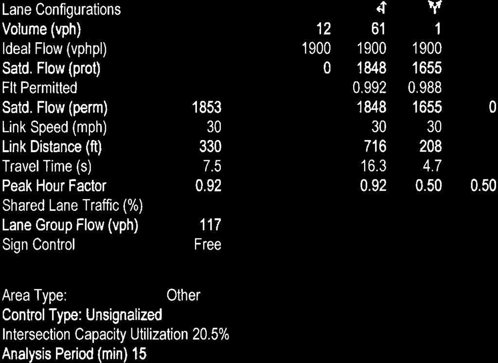
218
219
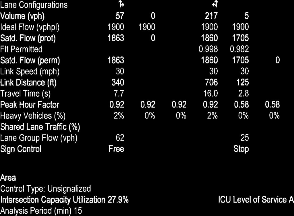
220
221
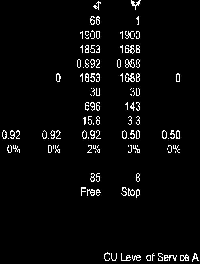
222
223
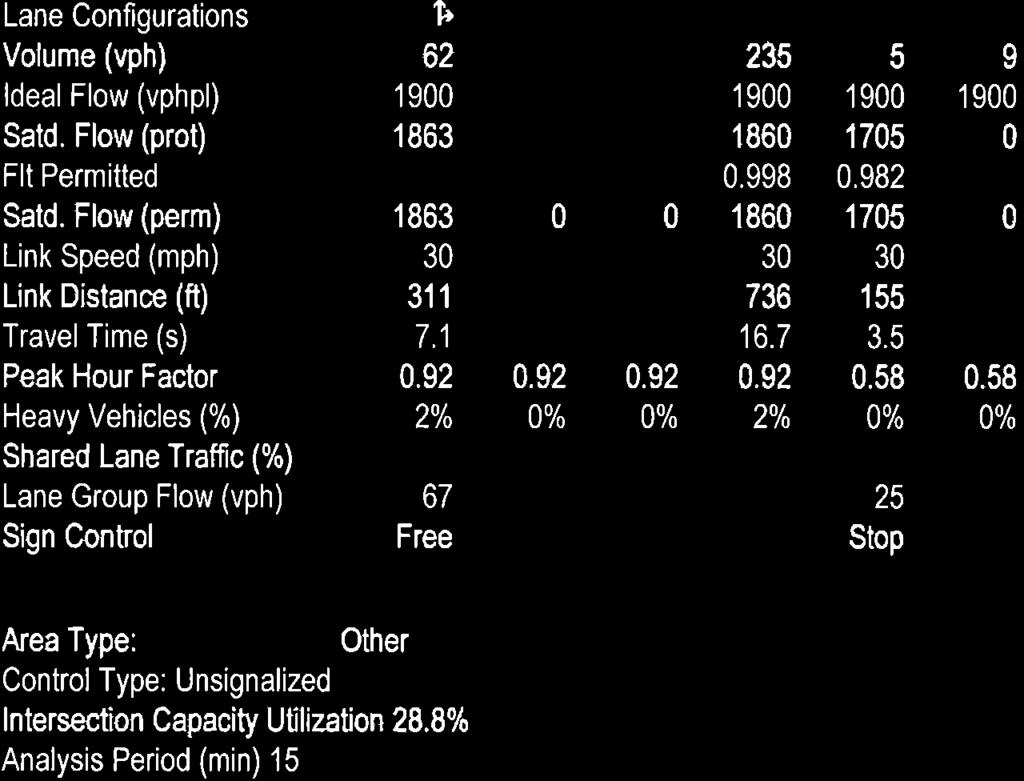
224
225
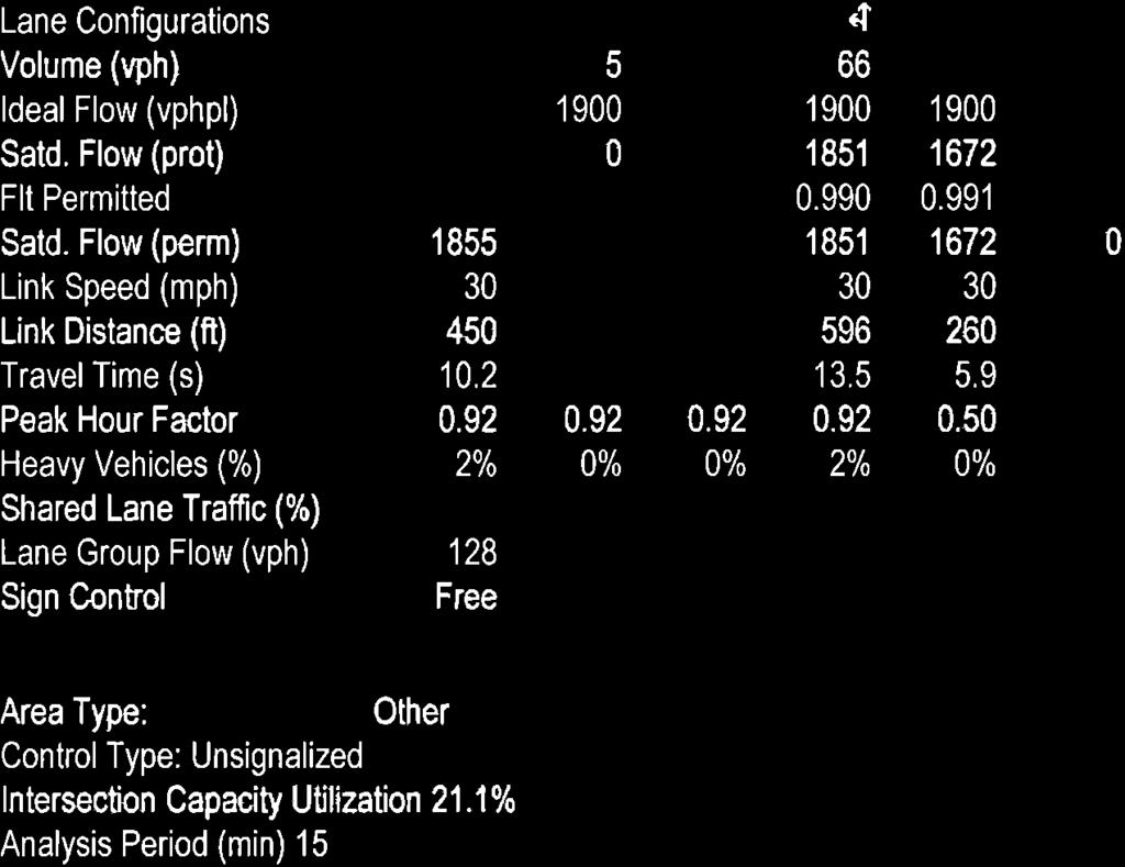
226
Traffic Impact and Access Study PROPOSED DURKEE FARM ESTATES. Foster Street Littleton, Massachusetts. Prepared for: Grimes Road, LLC.
 Traffic Impact and Access Study PROPOSED DURKEE FARM ESTATES Foster Street Littleton, Massachusetts Prepared for: Grimes Road, LLC. Westford, MA Prepared by: MDM Transportation Consultants, Inc. 28 Lord
Gateway Transportation Study
 Gateway Transportation Study Amherst, Massachusetts SUBMITTED TO University of Massachusetts Amherst Town of Amherst SUBMITTED BY Vanasse Hangen Brustlin, Inc. Watertown, Massachusetts March 213 Back of
Traffic Impact Analysis Walton Acres at Riverwood Athletic Club Clayton, NC
 Traffic Impact Analysis Walton Acres at Riverwood Athletic Club Clayton, NC 1. TABLE OF CONTENTS INTRODUCTION...1 1.1. Site Location and Study Area...1 1.2. Proposed Land Use and Site Access...2 1.3.
Traffic Impact Study WestBranch Residential Development Davidson, NC March 2016
 Traffic Impact Study WestBranch Residential Development Davidson, NC March 216 TRAFFIC IMPACT STUDY FOR THE WestBranch Residential Development LOCATED IN DAVIDSON, NC Prepared For: Lennar Carolinas, LLC
HYANNIS, MASSACHUSETTS TRANSPORTATION IMPROVEMENT PROGRAM
 PROJECT ACCESS (INCLUDED IN SITE DEVELOPMENT COSTS) Access to the Project will be provided by way of the private way to the south of the Project site that intersects the west side of Enterprise Road approximately
December 4, Merrimac Zoning Board of Appeals 2-8 School Street Merrimac, MA Attn: Kathy Marshall. Dear Board Members:
 December 4, 28 Merrimac Zoning Board of Appeals 2-8 School Street Merrimac, MA 86 Attn: Kathy Marshall RE: RAMSHEAD MERRIMAC, MA Dear Board Members: Bayside Engineering, Inc. has received the MDM Transportation
5858 N COLLEGE, LLC N College Avenue Traffic Impact Study
 5858 N COLLEGE, LLC nue Traffic Impact Study August 22, 2016 Contents Traffic Impact Study Page Preparer Qualifications... 1 Introduction... 2 Existing Roadway Conditions... 5 Existing Traffic Conditions...
TRAFFIC IMPACT STUDY And A TRAFFIC SIGNAL WARRANT ANALYSIS FOR A SENIOR LIVING AND APARTMENT DEVELOPMENT
 TRAFFIC IMPACT STUDY And A TRAFFIC SIGNAL WARRANT ANALYSIS FOR A SENIOR LIVING AND APARTMENT DEVELOPMENT DEERFIELD TOWNSHIP, WARREN COUNTY, OHIO Nantucket Circle and Montgomery Road () Prepared for: ODLE
METHODOLOGY. Signalized Intersection Average Control Delay (sec/veh)
") Chapter 5 Traffic Analysis 5.1 SUMMARY US /West 6 th Street assumes a unique role in the Lawrence Douglas County transportation system. This principal arterial street currently conveys commuter traffic
Chapter 5 Traffic Analysis 5.1 SUMMARY US /West 6 th Street assumes a unique role in the Lawrence Douglas County transportation system. This principal arterial street currently conveys commuter traffic
TRAFFIC IMPACT ANALYSIS
 TRAFFIC IMPACT ANALYSIS FOR THE CHAMPAIGN UNIT#4 SCHOOL DISTRICT PROPOSED HIGH SCHOOL (SPALDING PARK SITE) IN THE CITY OF CHAMPAIGN Final Report Champaign Urbana Urbanized Area Transportation Study 6/24/2014
Table of Contents FIGURES TABLES APPENDICES. Traffic Impact Study Hudson Street Parking Garage MC Project No.: A Table of Contents
 Traffic Impact Study Hudson Street Parking Garage MC Project No.: 151714A Table of Contents Table of Contents I. INTRODUCTION... 2 II. EXISTING CONDITIONS... 5 III. 215 EXISTING TRAFFIC CONDITIONS... 6
Transportation Impact Study for Abington Terrace
 Transportation Impact Study for Abington Terrace Abington Township, Montgomery County, PA Sandy A. Koza, P.E., PTOE PA PE License Number PE059911 Prepared by McMahon Associates, Inc. 425 Commerce Drive,
Magnolia Place. Traffic Impact Analysis. Prepared for: City of San Mateo. Prepared by: Hexagon Transportation Consultants, Inc.
 Magnolia Place Traffic Impact Analysis Prepared for: City of San Mateo Prepared by: Hexagon Transportation Consultants, Inc. Updated January 4, 2010 Table of Contents 1. Introduction...1 2. Existing Conditions...6
Date: April 4, Project #: Re: A Street/Binford Street Traffic/Intersection Assessment
 To: Peter Cavanaugh General Electric From: David Bohn, PE Ryan White, PE Date: April 4, 217 Project #: 13421. Re: / Traffic/Intersection Assessment Consistent with the Cooperation Agreement between the
Traffic Impact Analysis Chatham County Grocery Chatham County, NC
 Chatham County Grocery Chatham County, NC TABLE OF CONTENTS 1. INTRODUCTION... 1 1.1. Location and Study Area... 1 1.2. Proposed Land Use and Access... 2 1.3. Adjacent Land Uses... 2 1.4. Existing ways...
Glenn Avenue Corridor Traffic Operational Evaluation
 Glenn Avenue Corridor Traffic Operational Evaluation PREPARED FOR: THE CITY OF AUBURN PREPARED BY: DECEMBER 2007 Glenn Avenue Corridor Study--Auburn, Alabama TABLE OF CONTENTS Introduction... 1 Background
TRANSPORTATION ANALYSIS REPORT US Route 6 Huron, Erie County, Ohio
 TRANSPORTATION ANALYSIS REPORT US Route 6 Huron, Erie County, Ohio December 12, 2012 Prepared for: The City of Huron 417 Main Huron, OH 44839 Providing Practical Experience Technical Excellence and Client
THIS PAGE LEFT BLANK INTENTIONALLY
 GA SR 25 Spur at Canal Road Transportation Impact Analysis PREPARED FOR GLYNN COUNTY, GEORGIA 1725 Reynolds Street, Suite 300 Brunswick, Georgia 31520 PREPARED BY 217 Arrowhead Boulevard Suite 26 Jonesboro,
HENDERSON DEVELOPMENT 213, 217, 221, 221 ½, 223 HENDERSON AVENUE and 65 TEMPLETON STREET OTTAWA, ONTARIO TRANSPORTATION OVERVIEW.
 HENDERSON DEVELOPMENT 213, 217, 221, 221 ½, 223 HENDERSON AVENUE and 65 TEMPLETON STREET OTTAWA, ONTARIO TRANSPORTATION OVERVIEW Prepared for: 2294170 Ontario Inc. February 2, 2017 117-652 Report_1.doc
TRAFFIC IMPACT STUDY
 TRAFFIC IMPACT STUDY for the GLEN ELLEN COUNTRY CLUB SENIOR RESIDENTIAL REDEVELOPMENT 84 Millis, Massachusetts Prepared by: McMahon Associates, Inc. Prepared for: Toll Brothers, Inc. August 216 DRAFT
Traffic Circulation Study for Neighborhood Southwest of Mockingbird Lane and Airline Road, Highland Park, Texas
 ARIZONA TEXAS NEW MEXICO OKLAHOMA February 13, 2015 Mr. Meran Dadgostar P.E., R.S. Town of Highland Park 4700 Drexel Dr. Highland Park, Texas 75205 Re: Traffic Circulation Study for Neighborhood Southwest
Troutbeck Farm Development
 Troutbeck Farm Development Willistown Township, Chester County PA For Submission To: Willistown Township Last Revised: October, 4 TPD# INLM.A. 5 E. High Street Suite 65 Pottstown, PA 9464 6.36.3 TPD@TrafficPD.com
MEMORANDUM. Charlotte Fleetwood, Transportation Planner
 MEMORANDUM Date: Updated August 22, 2017 To: Organization: Charlotte Fleetwood, Transportation Planner Boston Transportation Department From: Jason DeGray, P.E., PTOE, Regional Director of Engineering
1609 E. FRANKLIN STREET HOTEL TRAFFIC IMPACT STUDY EXECUTIVE SUMMARY
 1609 E. FRANKLIN STREET HOTEL TRAFFIC IMPACT STUDY EXECUTIVE SUMMARY Prepared for: The Town of Chapel Hill Public Works Department Traffic Engineering Division Prepared by: HNTB North Carolina, PC 343
9 Leeming Drive Redevelopment Ottawa, ON Transportation Brief. Prepared By: Stantec Consulting Ltd.
 9 Leeming Drive Redevelopment Ottawa, ON Transportation Brief Prepared By: Stantec Consulting Ltd. TIA GUIDELINES CHECKLIST Report Context Municipal Address Comment: Section 1.1 Location relative to major
TRAFFIC IMPACT STUDY COMPREHENSIVE UPDATE TOWN OF THOMPSON S STATION, TENNESSEE PREPARED FOR: THE TOWN OF THOMPSON S STATION
 TRAFFIC IMPACT STUDY COMPREHENSIVE UPDATE TOWN OF THOMPSON S STATION, TENNESSEE PREPARED FOR: THE TOWN OF THOMPSON S STATION Transportation Consultants, LLC 1101 17 TH AVENUE SOUTH NASHVILLE, TN 37212
Date: September 7, Project #: Re: Spaulding Youth Center Northfield, NH Property. Traffic Impact Study
 To: Ms. Susan C. Ryan Spaulding Youth Center 72 Spaulding Road Northfield, NH 03276 Date: September 7, 2017 Project #: 52455.00 From: Robin Bousa Director of Transportation Systems Re: Spaulding Youth
TRANSPORTATION IMPACT STUDY PROPOSED RIVERFRONT 47 MIXED USE DEVELOPMENT
 November 2016 TRANSPORTATION IMPACT STUDY PROPOSED RIVERFRONT 47 MIXED USE DEVELOPMENT & Aspinwall Borough, Sharpsburg Borough & O Hara Township, Allegheny County, Pennsylvania Prepared for: Riverfront
Traffic Impact Study Little Egypt Road Development Denver, North Carolina June 2017
 Traffic Impact Study Little Egypt Road Development Denver, North arolina June 2017 N. Little Egypt Road DQ\ QDQFLQJ VDOHV RU RWKHU SHUIRUPDQFH EDVHG FULWHULD Proposed Site Driveways Site Driveway 1 TRAFFI
SECTION 1 - TRAFFIC PLANNING
 SECTION 1 - TRAFFIC PLANNING 1.1 TRAFFIC OPERATIONS 1.1.1 Roadway Functional Classification The Multnomah County Comprehensive Framework Plan s Policy 34: Trafficways and the Functional Classification
Highway 111 Corridor Study
 Highway 111 Corridor Study June, 2009 LINCOLN CO. HWY 111 CORRIDOR STUDY Draft Study Tea, South Dakota Prepared for City of Tea Sioux Falls Metropolitan Planning Organization Prepared by HDR Engineering,
D.13 Transportation and Traffic
 This section addresses transportation and traffic issues and impacts related to the Proposed Project. Section D.13.1 provides a description of the affected environment for the Proposed Project. Applicable
Route 28 (South Orleans Road)/Route 39 (Harwich Road)/Quanset Road Intersection
/Route 39 (Harwich Road)/Quanset Road Intersection") TRAFFIC FEASIBILITY STUDY Route 28 (South Orleans Road)/Route 39 (Harwich Road)/Quanset Road Intersection Orleans, Massachusetts Prepared for: Town of Orleans Prepared by: Fay, Spofford & Thorndike, LLC
TRAFFIC FEASIBILITY STUDY Route 28 (South Orleans Road)/Route 39 (Harwich Road)/Quanset Road Intersection Orleans, Massachusetts Prepared for: Town of Orleans Prepared by: Fay, Spofford & Thorndike, LLC
Traffic Impact Study. Westlake Elementary School Westlake, Ohio. TMS Engineers, Inc. June 5, 2017
 TMS Engineers, Inc. Traffic Impact Study Westlake Elementary School Westlake, Ohio June 5, 2017 Prepared for: Westlake City Schools - Board of Education 27200 Hilliard Boulevard Westlake, OH 44145 TRAFFIC
List of Attachments. Location Map... Site Plan... City of Lake Elsinore Circulation Element... City of Lake Elsinore Roadway Cross-Sections...
 List of Attachments Exhibits Location Map... Site Plan... City of Lake Elsinore Circulation Element... City of Lake Elsinore Roadway Cross-Sections... Existing Lane Geometry and Traffic Controls... Existing
QUICKIE C STORE AND GAS BAR 1780 HERON ROAD OTTAWA, ONTARIO TRANSPORTATION BRIEF. Prepared for:
 QUICKIE C STORE AND GAS BAR 1780 HERON ROAD OTTAWA, ONTARIO TRANSPORTATION BRIEF Prepared for: Quickie Convenience Stores Larny Holdings Ltd. c/o PBC Group April 15, 2015 115-615 Report_1.doc D. J. Halpenny
Walmart (Store # ) 60 th Street North and Marion Road Sioux Falls, South Dakota
 60 th Street North and Marion Road Sioux Falls, South Dakota") Walmart (Store #4865-00) 60 th Street North and Marion Road Sioux Falls, South Dakota Prepared for: Wal-Mart Stores, Inc. Bentonville, Arkansas Prepared by: Kimley-Horn and Associates, Inc. ã2013 Kimley-Horn
Walmart (Store #4865-00) 60 th Street North and Marion Road Sioux Falls, South Dakota Prepared for: Wal-Mart Stores, Inc. Bentonville, Arkansas Prepared by: Kimley-Horn and Associates, Inc. ã2013 Kimley-Horn
OFFICE/RETAIL DEVELOPMENT 1625 BANK STREET OTTAWA, ONTARIO TRANSPORTATION BRIEF. Prepared for: Canada Inc.
 OFFICE/RETAIL DEVELOPMENT 1625 BANK STREET OTTAWA, ONTARIO TRANSPORTATION BRIEF Prepared for: 9402209 Canada Inc. December 15, 2015 115-625 Report_2.doc D. J. Halpenny & Associates Ltd. Consulting Transportation
ALLEY 24 TRAFFIC STUDY
 ALLEY 24 TRAFFIC STUDY in City of Frostburg, Maryland January 2013 3566 Teays Valley Road Hurricane, WV Office: (304) 397-5508 www.denniscorporation.com Alley 24 Traffic Study January 2013 Frostburg, Maryland
A plan for improved motor vehicle access on Railroad Avenue in Provincetown
 A plan for improved motor vehicle access on Railroad Avenue in Provincetown February 2011 A plan for improved motor vehicle access on Railroad Avenue in Provincetown INTRODUCTION AND PROBLEM IDENTIFICATION
The Cape Cod Five Cents Savings Bank
 TRAFFIC IMPACT AND ACCESS STUDY The Cape Cod Five Cents Savings Bank Hyannis, Massachusetts PREPARED FOR The Cape Cod Five Cents Savings Bank 19 West Road Orleans, Massachusetts 0263 PREPARED BY 1 Walnut
Harrah s Station Square Casino
 Transportation Analysis Harrah s Station Square Casino Pittsburgh, Pennsylvania Submitted To: City of Pittsburgh and Pennsylvania Gaming Control Board Prepared By: DKS Associates GAI Consultants December
Traffic Impact and Access Study. The Preserve at Abbyville Proposed 40B Residential Development. Norfolk, Massachusetts
 Traffic Impact and Access Study The Preserve at Abbyville Proposed 40B Residential Development Norfolk, Massachusetts Prepared for DiPlacido Development Corp. April 2017 Prepared by GREEN INTERNATIONAL
MEDICAL/OFFICE BUILDING 1637 BANK STREET OTTAWA, ONTARIO TRANSPORTATION OVERVIEW. Prepared for:
 MEDICAL/OFFICE BUILDING 1637 BANK STREET OTTAWA, ONTARIO TRANSPORTATION OVERVIEW Prepared for: 2434984 Ontario Inc. 13-5510 Canotek Road Ottawa, Ontario K1J 9J5 June 4, 2015 115-613 Report_2.doc D. J.
Henderson Avenue Mixed-Use Development
 Zoning Case: Z145-3 Traffic Impact Analysis Henderson Avenue Mixed-Use Development Dallas, TX October 26 th, 216 Kimley-Horn and Associates, Inc. Dallas, Texas Project #644827 Registered Firm F-928 Traffic
INDUSTRIAL BUILDING 3009 HAWTHORNE ROAD CITY OF OTTAWA TRANSPORTATION OVERVIEW REVISED. Prepared for: Canada Inc.
 INDUSTRIAL BUILDING 3009 HAWTHORNE ROAD CITY OF OTTAWA TRANSPORTATION OVERVIEW REVISED Prepared for: 7849648 Canada Inc. Octiober 1, 2015 114-598 Overview_2.doc D. J. Halpenny & Associates Ltd. Consulting
Donahue Drive Corridor Traffic Operational Evaluation
 Donahue Drive Corridor Traffic Operational Evaluation PREPARED FOR: THE CITY OF AUBURN PREPARED BY: JANUARY 2007 Donahue Drive Corridor Study--Auburn, Alabama TABLE OF CONTENTS Introduction... 1 Background
Highway 49, Highway 351 and Highway 91 Improvements Feasibility Study Craighead County
 Highway 49, Highway 351 and Highway 91 Improvements Feasibility Study Craighead County Executive Summary March 2015 Highway 49, Highway 351 and Highway 91 Improvements Feasibility Study Craighead County
URBAN QUARRY HEADQUARTERS 2717 STEVENAGE DRIVE CITY OF OTTAWA TRANSPORTATION OVERVIEW. Prepared for: Urban Quarry 4123 Belgreen Drive, Ottawa K1G 3N2
 URBAN QUARRY HEADQUARTERS 2717 STEVENAGE DRIVE CITY OF OTTAWA TRANSPORTATION OVERVIEW Prepared for: Urban Quarry 4123 Belgreen Drive, Ottawa K1G 3N2 February 27, 2014 113-584 Overview_1.doc D. J. Halpenny
May 5, 2009 File:
 MMM Group Limited Suite 600 1455 West Georgia Street Vancouver, BC V6G 2T3 t: 604-685-9381 f: 604-683-8655 www.mmm.ca May 5, 2009 File: 50-09001-007 1420 1055 West Hastings Street Vancouver, BC V6E 2E9
Capital Region Council of Governments
 March 23, 2018 Capital Region Council of Governments PROJECT CONCEPT REPORT Realignment of Swamp and Northfield Road s approaches to Route 44 (Boston Turnpike) Town of Coventry SUMMARY: The Town of Coventry
TRAFFIC STUDY GUIDELINES Clarksville Street Department
 TRAFFIC STUDY GUIDELINES Clarksville Street Department 9/1/2009 Introduction Traffic studies are used to help the city determine potential impacts to the operation of the surrounding roadway network. Two
Traffic Study of Fuller Street, Cady Street, West Street and West Avenue. Final Report
 Traffic Study of Fuller Street, Cady Street, West Street and West Avenue Final Report July 2005 Prepared for: Town of Ludlow Prepared by: Pioneer Valley Planning Commission 26 Central Street West Springfield,
3.9 - Transportation and Traffic
 Transportation and Traffic 3.9 - Transportation and Traffic This section describes the potential transportation and traffic effects of project implementation on the project site and its surrounding area.
Marina Loft (DRC 51-R-12)
") Marina Loft (DRC 51-R-12) traffic study prepared for: Cymbal Development OCtober 2012 Traf Tech October 1, 2012 Mr. Asi Cymbal - President Cymbal Development 3470 North Miami Avenue Upper Suite Miami,
Marina Loft (DRC 51-R-12) traffic study prepared for: Cymbal Development OCtober 2012 Traf Tech October 1, 2012 Mr. Asi Cymbal - President Cymbal Development 3470 North Miami Avenue Upper Suite Miami,
MEETING FACILITY 2901 GIBFORD DRIVE CITY OF OTTAWA TRANSPORTATION BRIEF. Prepared for: Holiday Inn Express 2881 Gibford Drive Ottawa, ON K1V 2L9
 MEETING FACILITY 2901 GIBFORD DRIVE CITY OF OTTAWA TRANSPORTATION BRIEF Prepared for: Holiday Inn Express 2881 Gibford Drive Ottawa, ON K1V 2L9 December 18, 2012 112-566 Brief_1.doc D. J. Halpenny & Associates
NEW YORK CENTRAL PARK SUBDIVISION BLAIS STREET/ST-PIERRE STREET EMBRUN, ONTARIO TRAFFIC IMPACT STUDY. Prepared for:
 NEW YORK CENTRAL PARK SUBDIVISION BLAIS STREET/ST-PIERRE STREET EMBRUN, ONTARIO TRAFFIC IMPACT STUDY Prepared for: Solidex Holdings Limited & Investissement Maurice Lemieux Investments Attn: Mr. Anthony
Figure 1: Vicinity Map of the Study Area
 ARIZONA TEXAS NEW MEXICO OKLAHOMA May 5, 2016 Mr. Anthony Beach, P.E. BSP Engineers 4800 Lakewood Drive, Suite 4 Waco, Texas 76710 Re: Intersection and Access Analysis along Business 190 in Copperas Cove
TRAFFIC SIGNAL WARRANT STUDY
 TRAFFIC SIGNAL WARRANT STUDY 5 th STREET & ENCHANTED PINES DRIVE JANUARY 2013 TRAFFIC OPERATIONS ENGINEERING SERVICES/PUBLIC WORKS DEPARTMENT TABLE OF CONTENTS INTERSECTION LOCATION MAP ii INTRODUCTION
Shockoe Bottom Preliminary Traffic and Parking Analysis
 Shockoe Bottom Preliminary Traffic and Parking Analysis Richmond, Virginia August 14, 2013 Prepared For City of Richmond Department of Public Works Prepared By 1001 Boulders Pkwy Suite 300, Richmond, VA
Project Report. South Kirkwood Road Traffic Study. Meadows Place, TX October 9, 2015
 Meadows Place, TX October 9, 2015 Contents 1 Introduction... 1 2 Data Collection... 1 3 Existing Roadway Network... 2 4 Traffic Volume Development... 2 5 Warrant Analysis... 3 6 Traffic Control Alternative
Draft Report. Traffic Impact Study. Superstore, Wal-Mart, and Kent Development. Yarmouth, Nova Scotia. Prepared for
 oad & Traffic Management Road & Traffic Management R Atlantic Traffic Engineering Specialists Draft Report Traffic Impact Study Superstore, Wal-Mart, and Kent Development Yarmouth, Nova Scotia Prepared
TRAFFIC IMPACT STUDY. Creekside Thornton, Colorado. For. August 2015 November 2015 Revised: August Prepared for:
 TRAFFIC IMPACT STUDY For Creekside Thornton, Colorado August 215 November 215 Revised: August 216 Prepared for: Jansen Strawn Consulting Engineers 45 West 2 nd Avenue Denver, Colorado 8223 Prepared by:
The proposed development is located within 800m of an existing Transit Station where infill developments and intensification are encouraged.
 Stantec Consulting Ltd. 1331 Clyde Avenue, Suite 4 Ottawa ON K2C 3G4 Tel: (613) 722-442 Fax: (613) 722-2799 May 14, 213 File: 1638823 Robinson Park Development Corp. 5699 Power Road Ottawa, ON, K1G 3N4
MEMORANDUM. DATE March 1, 2012 TO Town of Milton Mark Abbott, Seth Asante, and Efi Pagitsas Boston Region MPO Staff
 MEMORANDUM DATE March 1, 212 TO Town of Milton FROM RE Mark Abbott, Seth Asante, and Efi Pagitsas Boston Region MPO Staff FFY 211 Safety and Operations Analyses at Selected Boston Region MPO Intersections:
Traffic Impact Study. Roderick Place Columbia Pike Thompson s Station, TN. Transportation Group, LLC Traffic Engineering and Planning
 F i s c h b a c h Transportation Group, LLC Traffic Engineering and Planning Traffic Impact Study Roderick Place Columbia Pike Thompson s Station, TN Prepared March 2016 Ms. Gillian L. Fischbach, P.E.,
TRAFFIC ASSESSMENT River Edge Colorado
 TRAFFIC ASSESSMENT River Edge Colorado Submitted by: Fehr & Peers 621 17th Street, Ste. 231 Denver, CO 8293 (33) 296-43 December, 21 App. M-2 Traffic Assessment River Edge Colorado December 21 TABLE OF
MEMORANDUM. Layout Of Study Intersections And Traffic Control
 BOSTON REGION METROPOLITAN PLANNING ORGANIZATION Richard A. Davey, MassDOT Secretary and CEO and MPO Chairman Karl H. Quackenbush, Executive Director, MPO Staff DATE November 15, 2012 TO FROM RE Town of
Traffic Analysis and Design Report. NW Bethany Boulevard. NW Bronson Road to NW West Union Road. Washington County, Oregon
 Traffic Analysis and Design Report NW Bethany Boulevard NW Bronson Road to NW West Union Road Washington County, Oregon May 2011 Table of Contents Table of Contents Section 1 Executive Summary... 2 Section
Paul VI Redevelopment. Traffic Impact Study
 ATTACHMENT 5 Paul VI Redevelopment Traffic Impact Study April 18, 2017 PAUL VI REDEVELOPMENT TRAFFIC IMPACT STUDY CITY OF FAIRFAX, VIRGINIA Prepared for: IDI GROUP COMPANIES Prepared by: Wells + Associates,
4.0 TRAFFIC IMPACT STUDIES
 SECTION 4 4.0 TRAFFIC IMPACT STUDIES 4.1 TRAFFIC IMPACT STUDY REQUIREMENTS The City has established Traffic Impact Study (TIS) requirements for the purpose of ensuring that both the quantitative and qualitative
List of Exhibits...ii
 One Brickell Traffic Study TABLE OF CONTENTS List of Exhibits...ii EXECUTIVE SUMMARY...1 1. INTRODUCTION...2 1.1 Study Area...2 1.2 Study Objective...5 2. EXISTING TRAFFIC CONDITIONS...6 2.1 Data Collection...6
COMMERCIAL DEVELOPMENT 2015 ROBERTSON ROAD OTTAWA, ONTARIO TRANSPORTATION BRIEF. Prepared for:
 COMMERCIAL DEVELOPMENT 2015 ROBERTSON ROAD OTTAWA, ONTARIO TRANSPORTATION BRIEF Prepared for: First Bay Properties Inc. 311 Richmond Road, Suite 203 Ottawa, ON K1Z 6X3 August 8, 2017 117-663 Brief_1.doc
TRASBURG RANSPORTATION
 TRASBURG RANSPORTATION LAN DEVELOPED BY THE TRANSPORTATION PLANNING DIVISION OF THE VIRGINIA DEPARTMENT OF TRANSPORTATION IN COOPERATION WITH THE U.S. DEPARTMENT OF TRANSPORTATION, FEDERAL HIGHWAY ADMINISTRATION
EXECUTIVE SUMMARY. Page 1 of 6
 EXECUTIVE SUMMARY The purpose of this report is to identify conformance with the original traffic impact study for the proposed retail development on Lot 5 of Riverdale Retail Filing No. 1 located on the
INTRODUCTION THOROUGHFARE SYSTEM CLASSIFICATIONS
 INTRODUCTION The thoroughfare plan will assist public officials in the development of a specialized system for efficient and safe movement of vehicular traffic while minimizing potential conflicts with
STILLWATER AVENUE CORRIDOR STUDY Old Town, Maine
 Draft Study STILLWATER AVENUE CORRIDOR STUDY Old Town, Maine SUBMITTED TO: BANGOR AREA COMPREHENSIVE TRANSPORTATION SYSTEM SUBMITTED BY: I MAY 23, 2017 DRAFT STILLWATER AVENUE STUDY FINAL REPORT Table
Evaluation of M-99 (Broad Street) Road Diet and Intersection Operational Investigation
 Road Diet and Intersection Operational Investigation") Evaluation of M-99 (Broad Street) Road Diet and Intersection Operational Investigation City of Hillsdale, Hillsdale County, Michigan June 16, 2016 Final Report Prepared for City of Hillsdale 97 North Broad
Evaluation of M-99 (Broad Street) Road Diet and Intersection Operational Investigation City of Hillsdale, Hillsdale County, Michigan June 16, 2016 Final Report Prepared for City of Hillsdale 97 North Broad
Technical Memorandum TRAFFIC IMPACT STUDY. RIDLEY ROAD CONVENIENCE STORE Southampton County, VA. Prepared for: Mr. David Williams.
 Technical Memorandum TRFFIC IMPCT STUDY RIDLEY ROD CONVENIENCE STORE Southampton County, V Prepared for: Mr. David Williams By: Charles Smith, P.E., PTOE EPR Charlottesville, V July 2014 1 TBLE OF CONTENTS
Chapter 4 Traffic Analysis
 Chapter 4 Traffic Analysis PURPOSE The traffic analysis component of the K-68 Corridor Management Plan incorporates information on the existing transportation network, such as traffic volumes and intersection
TABLE OF CONTENTS TABLE OF CONTENTS... I APPENDICES... III LIST OF EXHIBITS... V LIST OF TABLES... VII LIST OF ABBREVIATED TERMS...
 TABLE OF CONTENTS TABLE OF CONTENTS... I APPENDICES... III LIST OF EXHIBITS... V LIST OF TABLES... VII LIST OF ABBREVIATED TERMS... IX 1 INTRODUCTION... 1 1.1 Project Overview... 1 1.2 Analysis Scenarios...
Proposed Lowe s Home Improvement Center
 Traffic Impact and Access Study Proposed Lowe s Home Improvement Center Dennis, Massachusetts Prepared for Prepared by Lowe s Home Centers, Inc. 1605 Curtis Bridge Road Wilkesboro, North Carolina 28697
 TRAFFIC IMPACT STUDY CANYON HILLS PROJECT LOS ANGELES, CALIFORNIA INTRODUCTION This traffic analysis has been conducted to identify and evaluate the potential traffic impacts of the proposed Canyon Hills
Plymouth Rubber Redevelopment
 TRAFFIC IMPACT AND ACCESS STUDY Plymouth Rubber Redevelopment Canton, Massachusetts PREPARED FOR Canton Holdings, LLC c/o North American Real Estate Management 1 East Oak Hill Drive, Suite 11 Westmont,
M-58 HIGHWAY ACCESS MANAGEMENT STUDY Mullen Road to Bel-Ray Boulevard. Prepared for CITY OF BELTON. May 2016
 M-58 HIGHWAY ACCESS MANAGEMENT STUDY Prepared for CITY OF BELTON By May 2016 Introduction Missouri State Highway 58 (M-58 Highway) is a major commercial corridor in the City of Belton. As development has
TRAFFIC IMPACT STUDY CRITERIA
 Chapter 6 - TRAFFIC IMPACT STUDY CRITERIA 6.1 GENERAL PROVISIONS 6.1.1. Purpose: The purpose of this document is to outline a standard format for preparing a traffic impact study in the City of Steamboat
Figure 1: East West Connector Alignment Alternatives Concept Drawing
 Page 2 of 9 Figure 1: East West Connector Alignment Alternatives Concept Drawing The Montebello Drive extension will run north south and connect Wilsonville Road to the Boones Ferry Road to Brown Road
CURBSIDE ACTIVITY DESIGN
 5 CURBSIDE ACTIVITY DESIGN This chapter provides design guidance for separated bike lanes adjacent to curbside activities including parking, loading and bus stops. Typical configurations are presented
MEMORANDUM. Nantasket Road at Kingsley Road Kingsley Road at Sumner Street Kingsley Road at Revere Street Kingsley Road at Kenberma Street
 MEMORANDUM Date: June 28, 2012 To: From: Subject: Mr. Joseph Stigliani, Director of Public Works Kenneth J. Petraglia, P.E., PTOE Greg E. Lucas, P.E., PTOE Kingsley Road Stop Sign Warrant Analysis BETA
Dear Mr. Tweed: Sincerely, Min Zhou, P.E. Vice President
 December 17, 2012 Mr. Steve Tweed City of Long Beach, Department of Public Works Traffic & Transportation Bureau, 10 th Floor City Hall 333 West Ocean Boulevard Long Beach, CA 90802 Subject: Broadway and
TRAFFIC STUDY. Birch Bluff Road / Pleasant Avenue 01/15/2018. City of Tonka Bay 4901 Manitou Road Tonka Bay, MN WSB PROJECT NO.
 TRAFFIC STUDY Birch Bluff Road / Pleasant Avenue 01/15/2018 City of Tonka Bay 4901 Manitou Road Tonka Bay, MN 55331 WSB PROJECT NO. 10805-000 Birch Bluff Road/ Pleasant Avenue Traffic Study For: City of
Traffic Impact Study for Rolling Ridge Redevelopment
 Traffic Impact Study for Rolling Ridge Redevelopment Webster Groves, Missouri October 19, 2018 Prepared For: Gershman Commercial Real Estate 150 North Meramec Avenue Suite 500 St. Louis, Missouri 63105
Washington St. Corridor Study
 FIGURE 7.17 Bridge Alternatives - Cross Sections 86 Discarded Alternative: Short-Term Bridge Repair Short-term repairs and west bridge span replacement were considered during analysis. Short-term repairs
INDUSTRIAL BUILDING 1660 COMSTOCK ROAD CITY OF OTTAWA TRANSPORTATION OVERVIEW. Prepared for:
 INDUSTRIAL BUILDING 1660 COMSTOCK ROAD CITY OF OTTAWA TRANSPORTATION OVERVIEW Prepared for: Simluc Contractors Limited 2550 Blackwell Street, Ottawa K1B 5R1 October 18, 2013 113-584 Overview_1.doc D. J.
CHAPTER 4 TRANSPORTATION IMPACT STUDY TABLE OF CONTENTS
 CHAPTER 4 TRANSPORTATION IMPACT STUDY TABLE OF CONTENTS Section Title Page 4.1 Introduction... 4-1 4.1.1 General... 4-1 4.1.2 Applicant Responsibility... 4-1 4.1.3 Capacity and Safety Issues... 4-1 A.
DIMARCO CANANDAIGUA PROPERTIES HOUSING PROJECT CANANDAIGUA, ONTARIO COUNTY, NEW YORK
 TRAFFIC IMPACT STUDY FOR THE DIMARCO CANANDAIGUA PROPERTIES HOUSING PROJECT CANANDAIGUA, ONTARIO COUNTY, NEW YORK MARCH 14, 2017 PREPARED FOR: 1950 Brighton Henrietta Town Line Rd Rochester, NY 14623 PREPARED
DRAFT Davidson Elementary School Expansion Transportation Impact Analysis
 DRAFT Davidson Elementary School Expansion Transportation Impact Analysis Prepared for: Town of Davidson 216 S. Main Street Davidson, NC 28036 Prepared by: Stantec Consulting Services Inc. 2127 Ayrsley
TOWN OF CHAPEL HILL POLICY AND PROCEDURES FOR TRAFFIC CALMING MEASURES
 TOWN OF CHAPEL HILL POLICY AND PROCEDURES FOR TRAFFIC CALMING MEASURES (Adopted by the Town Council on June 30, 2004) (Revised December 6, 2010) (Revised February 8, 2016) POLICY AND PROCEDURES FOR TRAFFIC
VIVA RETIREMENT COMMUNITIES OAKVILLE TRAFFIC IMPACT STUDY
 VIVA RETIREMENT COMMUNITIES OAKVILLE TRAFFIC IMPACT STUDY VIVA RETIREMENT COMMUNITIES OAKVILLE TRAFFIC IMPACT STUDY DECEMBER 2012 READ, VOORHEES & ASSOCIATES TORONTO, ONTARIO Read, Voorhees & Associates
4. ENVIRONMENTAL IMPACT ANALYSIS 9. TRANSPORTATION AND TRAFFIC
 4. ENVIRONMENTAL IMPACT ANALYSIS 9. TRANSPORTATION AND TRAFFIC 4.9.1 INTRODUCTION The following section addresses the Proposed Project s impact on transportation and traffic based on the Traffic Study