Proposed Lowe s Home Improvement Center
|
|
|
- Curtis Baldric Watson
- 5 years ago
- Views:
Transcription
1 Traffic Impact and Access Study Proposed Lowe s Home Improvement Center Dennis, Massachusetts Prepared for Prepared by Lowe s Home Centers, Inc Curtis Bridge Road Wilkesboro, North Carolina /Vanasse Hangen Brustlin, Inc. Transportation, Land Development, Environmental Services 101 Walnut Street P.O. Box 9151 Watertown, Massachusetts January 2013
2 Table of Contents Introduction... i Project Description... i Study Methodology... i Existing Conditions... 3 Study Area... 3 Roadway Geometry... 4 Roadways... 4 Intersections... 4 Roadway Jurisdiction... 9 Traffic Volume Data... 9 Seasonality of Count Data Public Transportation Vehicular Crash History Future Conditions Background Traffic Growth Historic Traffic Growth Site-Specific Growth No-Build Traffic Volumes Future Roadway Conditions Trip Generation Trip Distribution and Assignment Traffic Operations Analysis Level-of-Service and Delay Criteria Level-of-Service Analysis Signalized Intersection Capacity Analyses Unsignalized Intersection Capacity Analyses Roadway Link Capacity Analysis Mitigation Transportation Demand Management Intersection/Roadway Safety Mitigation Fair Share Mitigation Conclusion i Table of Contents
3 List of Tables Table Title Page Table 1 Peak Season Existing Traffic Volumes Table 2: Vehicular Crash Data ( ) Table 3 Proposed Project Trip Generation Breakdown Table 4 Proposed Project Trip Distribution Table 5 Signalized Intersection Capacity Analysis Summary Peak Summer Season Table 6 Unsignalized Intersection Capacity Analyses - Peak Summer Season Table 7 Roadway Link Analysis Summary Peak Summer Season Table 8 Trip Reduction Requirement Calculation Table 9 Signalized Intersection Capacity Analysis Summary Peak Summer Season Table 10 Fair Share Mitigation Assessment Weekday Evening Peak Hour Table 11 Mitigation Plan Cost Summary ii List of Tables
4 List of Figures Figure Title Follows Page 1 Site Location Map Study Area Intersection Geometry Roadway Jurisdiction Map Existing Weekday Evening Peak Hour Traffic Volumes Existing Saturday Midday Peak Hour Traffic Volumes No Build Weekday Evening Peak Hour Traffic Volumes No-Build Saturday Midday Peak Hour Traffic Volumes Project Trip Distribution Build Weekday Evening Peak Hour Traffic Volumes Build Saturday Midday Peak Hour Traffic Volumes Proposed Roadway Improvements Route 134 Corridor Proposed Roadway Improvements Theophilus F. Smith Road iii List of Figures
5 Executive Summary Vanasse Hangen Brustlin, Inc. (VHB) has prepared a traffic impact and access study (TIAS) for the proposed Lowe s Home Improvement Center (the Project ) to be located along Theophilus F. Smith Road in Dennis, Massachusetts. As designated on the land use vision map for the Town of Dennis, the site is located in an Economic Center. The site currently consists of approximately 15 acres of land which currently house the local Dick and Ellie s Flea Market and the Inflatable Park during the summer season. The existing land uses do not currently generate activity on site during the winter months. The proposed project would involve the redevelopment of the site to include an approximately 135,018 sf Lowes Home Improvement Center with approximately 390 parking spaces. Access to the site would be provided by three full access driveways on Theophilus F. Smith (TFS) Road. The easterly driveway will be an unsignalized T-type intersection with TFS Road which will be designated for truck delivery. The middle site driveway will be an unsignalized T-type intersection with TFS Road. The westerly driveway will be under traffic signal control and will involve the realignment of Enterprise Road to form the southbound approach to the intersection. By introducing the traffic signal and realigning Enterprise Road to align with the site driveway, we are providing access management along this corridor. Based on a review of the anticipated trip generation and trip distribution for the proposed project, a study area was established. The study area was established also in part based on a review of the RPP and the RPP Functional Classification of Cape Cod Roadways Map, and through consultations with both the Town and Cape Cod Commission. Using this approach, the project study area will include the following 20 intersections: Theophilus F. Smith Road and Site Driveways (2) Theophilus F. Smith Road at Duck Pond Road/S. Gages Way Route 134 and Theophilus F. Smith Road Route 134 and Market Place/Patriot Square Access Driveway Theophilus F. Smith Road and Enterprise Road Main Street at High Bank Road Old Bass River Road at Bob Crowell Road Old Bass River Road at Mayfair Road Route 134 and Route 6 Interchange (four-intersections) Route 134 at Airline Road Route 134 and Bob Crowell Road Route 134 and Upper County Road Route 134 and Main Street (Route 28) S. Gages Way at Great Western Road iv Executive Summary
6 Great Western Road at Depot Street (Harwich) Depot Street at Depot Road (Harwich) Manual turning movement counts [collecting peak hour data] were conducted at each of the study-area intersections during the weekday evening peak period from 4:00 PM to 6:00 PM and the Saturday midday peak period from 11:00 AM to 1:00 PM in August Concurrent with the TMCs, 24-hour automatic traffic recorder (ATR) counts were conducted at the following three locations: Route 134 south of Route 6 Theophilus F. Smith Road east of Route 134 Enterprise Road north of Theophilus F. Smith Road The proposed project is expected to result in a total of 2,334 net new trips (1,167 entering/1,167 exiting) on a typical weekday and 4,308 net new trips (2,154 entering/2,154exiting) on a typical Saturday. The proposed project is expected to result in a total of 241 net new vehicle trips (127 entering/114 exiting) during the weekday evening peak hour and 342 net new vehicle trips (176 entering/166 exiting) during the Saturday midday peak hour. Capacity analyses were conducted for each of the study area intersections and roadway links under 2013 Existing conditions, 2018 No-Build conditions (without the proposed development), and 2018 Build conditions (with the proposed development). Based on the results of these analyses and the anticipated sitegenerated traffic, the proponent will implement the following measures as part of the proposed transportation initiatives of the proposed project: Provide a comprehensive Transportation Demand Management Program (TDM) Provide monetary contribution to public transit Implement intersection safety and/or capacity enhancements at: o Theophilus F. Smith Road and Enterprise Road/Site Driveways o Route 134 and Theophilus F. Smith Road o Route 134 and Market Place/Patriot Square Access Driveway o Route 134 and Route 6 Eastbound Ramps o Route 134 and Route 6 Westbound Ramps o Route 134 at Airline Road o Route 134 and Bob Crowell Road o Route 134 and Main Street (Route 28) Provide Fair Share contribution towards additional improvements in the study area Overall, VHB concludes that the implementation of the above-mentioned mitigation measures not only accommodates future site-generated traffic but also improves some existing operational deficiencies in the vicinity of the site. v Executive Summary
7 1 Introduction This traffic study documents the findings of the traffic evaluation conducted for the project including an assessment of existing conditions, projection of future traffic volumes without and with the proposed development, analysis of impacts of the proposed development and recommendations for improving existing capacity deficiencies as well as to offset project related traffic impacts. Project Description The site, which is located on Theophilus F. Smith Road in Dennis, Massachusetts, currently consists of approximately 15 acres of land which currently house the local Dick and Ellie s Flea Market and the Inflatable Park during the summer season. The existing land uses do not currently generate activity on site during winter months. The proposed project would involve the redevelopment of the site to include an approximately 135,018 sf Lowes Home Improvement Center with approximately 390 parking spaces. Access to the proposed site would be provided by three full-access driveways (two unsignalized and one signalized with a realigned Enterprise Road). Figure 1 shows the Project site in relation to the surrounding area. Study Methodology This traffic assessment has been conducted in three stages. The first stage involved an assessment of existing traffic conditions within the project area including an inventory of existing roadway geometry; observations of traffic flow, including daily and peak period traffic counts; and a review of vehicular crash data. The second stage of the study established the framework for evaluating the transportation impacts of the proposed project. Specific travel demand forecasts for the project were assessed along with future traffic demands on the study area roadways due to projected background traffic growth and other proposed area development that will occur, independent of the proposed development. The year 2018, a five-year time horizon, was selected as the design year for analysis for the preparation of this traffic impact and access assessment to satisfy the Executive Office of Environmental Affairs/Executive Office of Transportation [EOEA/EOT] guidelines and CCC DRI requirement. 1 Introduction
8
9 2 Introduction The third and final stage involved conducting traffic analyses to identify both existing and projected future roadway capacities and demands. This analysis was used as the basis for determining potential project impacts and potential mitigation measures.
10 2 Existing Conditions Evaluation of the transportation impacts associated with the proposed project requires a thorough understanding of the existing transportation system in the project study area. Existing transportation conditions in the study area include roadway geometry, traffic controls, daily and peak period traffic flow, and vehicular crash information data. Each of these elements is described in detail below. Study Area Based on a review of the anticipated trip generation and trip distribution for the proposed project, a study area was established. The study area was established also in part based on a review of the RPP and the RPP Functional Classification of Cape Cod Roadways Map and through consultation with CCC and the Town of Dennis. Using this approach, the project study area will include the following 20 intersections: Theophilus F. Smith Road and Site Driveways (3) Theophilus F. Smith Road at Duck Pond Road/S. Gages Way Route 134 and Theophilus F. Smith Road Route 134 and Market Place/Patriot Square Access Driveway Theophilus F. Smith Road and Enterprise Road Main Street at High Bank Road Old Bass River Road at Bob Crowell Road Old Bass River Road at Mayfair Road Route 134 and Route 6 Interchange (four-intersections) Route 134 at Airline Road Route 134 and Bob Crowell Road Route 134 and Upper County Road Route 134 and Main Street (Route 28) S. Gages Way at Great Western Road Great Western Road at Depot Street (Harwich) Depot Street at Depot Road (Harwich) The existing conditions evaluation consisted of an inventory of the traffic control; roadway, driveway, and intersection geometry in the study area; the collection of daily and peak period traffic volumes; and a review of recent vehicular crash history. 3 Existing Conditions
11 Roadway Geometry Roadways The major travel routes and intersections within the study area are described below. Figure 2 shows the observed existing geometry and traffic control at each study-area intersection. Route 134 Route 134 within the study area ranges from a two-lane to a four-lane roadway running generally in a north-south direction. Route 134 is under local jurisdiction with the exception of the section of roadway at the Route 6 interchange. The posted speed limit along Route 134 varies between 35 mph and 45 mph. Land use along Route 134 predominantly consists of commercial uses in the vicinity of the project site, with some residential uses north of the Route 6 interchange. Theophilus F. Smith Road Intersections Theophilus F. Smith Road (TFS Road) within the study area is a two-lane roadway running generally in an east-west direction. TFS Road is under local jurisdiction and provides two travel lanes with variable shoulder widths. The posted speed limit along TFS Road varies between 25 mph and 35 mph within the study area. Land use along TFS Road is a mix of retail, industrial and other commercial uses. The following sections describe the study-area intersections in detail. Theophilus F. Smith Road at S. Gages Way/Duck Pond Road Four-legged unsignalized intersection Intersection is under all-way STOP control All approaches provides a single general purpose lane Southbound leg provides access to the Transfer Station No sidewalks are provided at the intersection No crosswalks are provided at the intersection Land use in the area is primarily commercial and industrial 4 Existing Conditions
12
13 Theophilus F. Smith Road at Enterprise Road Three-legged unsignalized intersection Southbound approach provides a general purpose lane and is under STOP control Eastbound and Westbound approach provide a single general purpose lane No sidewalks are provided at the intersection No crosswalks are provided at the intersection Land use in the area is primarily retail, including Cranberry Square Plaza, Cumberland Farms, and Entertainment Cinemas Route 134 at Theophilus F. Smith Road Three-legged signalized intersection Northbound approach provides two general purpose lanes Southbound approach provides two general purpose lanes and an exclusive left-turn lane Westbound approach provides exclusive left and right-turn lanes A two-way left-turn lane is present just south of Theophilus F. Smith Road Sidewalk is provided along the east side of Route 134 A crosswalk is provided across Theophilus F. Smith Road Land use in the area is primarily retail, including two gas stations and the Mid-Cape Home Center Route 134 at Market Place/Patriot Square Access Four-legged signalized intersection Northbound and Southbound approaches provide an exclusive left-turn lane and two general purpose lanes Eastbound and Westbound approaches provide an exclusive left-turn lane, a through lane, and a channelized right-turn lane Sidewalk is provided along the east side of Route 134 A crosswalk is provided across Route 134 south of Market Place Land use in the area is primarily retail, including Patriot Square and Market Place shopping centers Main Street/Old Bass River Road at High Bank Road Four-legged unsignalized intersection Intersection is under all-way STOP control All approaches provides a single general purpose lane Sidewalk is provided along the east side of Old Bass River Road and Main Street A crosswalk is provided across the westbound approach Land use in the area is primarily residential 5 Existing Conditions
14 Old Bass River Road at Bob Crowell Road Three-legged unsignalized intersection Westbound approach is under STOP control All approaches provides a single general purpose lane Sidewalk is provided along the east side of Old Bass River Road A crosswalk is provided across the westbound approach Land use in the area consists of residential properties, the Johnny Kelley Recreation Area, the former site of the Dennis DPW, and a multi-unit public apartment building Old Bass River Road at Mayfair Road Three-legged unsignalized intersection Eastbound approach is under STOP control All approaches provides a single general purpose lane Sidewalk is provided along the east side of Old Bass River Road A crosswalk is provided across the eastbound approach Land use in the area consists of residential properties, a Masonic Lodge, and a multiunit public apartment building Route 134 at Route 6 Eastbound Ramps Full cloverleaf interchange Route 134 northbound provides two general purpose lanes Route 134 southbound provides a single lane general purpose lane Route 6 eastbound off ramp provides an exclusive lane to Route 134 southbound but is under YIELD control No sidewalks are provided at the intersection No crosswalks are provided at the intersection Land use in the area is a mix of commercial and residential Route 134 at Route 6 Westbound Ramps Full cloverleaf interchange Route 134 northbound provides a through lane and an exclusive right-turn lane Route 134 southbound provides a single lane general purpose lane No sidewalks are provided at the intersection No crosswalks are provided at the intersection Land use in the area is primarily residential 6 Existing Conditions
15 Route 134 at Bob Crowell Road Four-legged signalized intersection Northbound approach provides an exclusive left-turn lane and a general purpose lane Southbound approach provides an exclusive left-turn lane, a through lane, and a general purpose lane Eastbound approach provides a general purpose lane and a channelized right-turn lane Westbound approach provides a single general purpose lane Sidewalk is provided along the west side of Route 134 north of Bob Crowell Road No crosswalks are provided at the intersection Land use in the area includes retail, residential, and the police station Route 134 at Airline Road Three-legged unsignalized, Y-type intersection Westbound approach is under STOP control All approaches provides a single general purpose lane Sidewalk is provided along the west side of Route 134 No crosswalks are provided at the intersection Land use in the area consists of residential properties and the Doane Beal & Ames funeral home Route 134 at Upper County Road Five-legged signalized intersection Northbound and Southbound approaches provide an exclusive left-turn lane, two general purpose lanes, and a brief channelized right-turn lane Eastbound approach provides an exclusive left-turn lane and a general purpose lane Westbound approach provides a general purpose lane and an exclusive right-turn lane Duck Pond Road is the fifth leg and is one way traveling away from the intersection Sidewalk is provided along the north side of Upper County Road and the east side of Route 134. No crosswalks are provided at the intersection Land use in the area is primarily residential 7 Existing Conditions
16 Route 134 at Main Street (Route 28) Four-legged signalized intersection Northbound approach provides a single general purpose lane Southbound approach provides an exclusive left-turn lane and a general purpose lane Eastbound and Westbound approaches provide a general purpose lane and an exclusive left-turn lane Sidewalks and crosswalks are provided on all four approaches to the intersection Land use in the area includes retail, restaurant, and bank uses S. Gages Way at Great Western Road Three-legged unsignalized intersection Southbound approach is under STOP control All approaches provides a single general purpose lane The Cape Cod Rail Trail runs east/west along the north side of Great Western Road No crosswalks are provided at the immediate intersection, but a crossing of the Cape Cod Rail Trail is provided north of Great Western Road Land use in the area is primarily commercial/industrial Great Western Road at Depot Street Two offset, three-legged unsignalized intersections Northbound and Southbound approaches provide a single lane under STOP control Eastbound and westbound approaches provide an exclusive left-turn lane and a general purpose lane No sidewalks are provided at the intersection No crosswalks are provided at the intersection Land use in the area is primarily commercial/industrial Depot Street at Depot Road Three-legged unsignalized, Y-type intersection Northbound approach is under STOP control All approaches provides a single general purpose lane No sidewalks are provided at the intersection No crosswalks are provided at the intersection Land use in the area is primarily residential 8 Existing Conditions
17 Roadway Jurisdiction Roadways within the Town of Dennis are either under the jurisdiction of the Town of Dennis or MassDOT. Within the project study area, all roadways are under local jurisdiction with the exception of Route 6 and Route 28, and a section of Route 134 at the Route 6 interchange which are under MassDOT jurisdiction. Figure 3 illustrates the roadway jurisdiction designations within the study area. Traffic Volume Data Manual turning movement counts [collecting peak hour data] were conducted at each of the study-area intersections during the weekday evening peak period from 4:00 PM to 6:00 PM, and the Saturday midday peak period from 11:00 AM to 1:00 PM. It is during these two periods when the combination of site traffic and area background traffic are at their most critical level. These counts were conducted in August 2012, which represents peak summer conditions (except for the intersection of Depot Street at Depot Road, which was counted in September 2012). The weekday evening peak period is consistent with typical peak commuter traffic periods, and coincide with the expected peak periods for traffic entering and exiting the proposed site. The Saturday midday peak period is consistent with the typical peak of shopping/commercial activity and turn-over for summer rental properties. These periods represent the most critical traffic volume conditions. Based on the TMCs, the weekday evening peak period generally occurred from 4:00 to 5:00 PM and the Saturday midday peak period occurred from 11:00 AM to 12:00 PM. Concurrent with the TMCs, 72-hour automatic traffic recorder (ATR) counts were conducted on Route 134, Theophilus F. Smith Road, and Enterprise Road. A summary of the ATR traffic data is presented in Table 1. All traffic count data is contained in the Appendix. 9 Existing Conditions
18
19 Table 1 Peak Season Existing Traffic Volumes Weekday Weekday PM Peak Period Saturday Saturday Midday Peak Period ADT a Volume b K c Dir. Dist d ADT a Volume b K c Dir. Dist d Route 134 Northbound south of Route 6 Route 134 Southbound south of Route 6 Theophilus F. Smith Road east of Route 134 Enterprise Road north of Theophilus F Smith Rd. 16,900 1, % 100% NB 16,750 1, % 100% NB 17,220 1, % 100% SB 16,850 1, % 100% NB 10, % 57% WB 10,220 1, % 53% WB 5, % 53% SB 5, % 54% SB a b c d daily traffic expressed in vehicles per day. Based on daily volumes for Thursday August 23, 2012 and Saturday August 25, Exact peak hours of the ATRs may not coincide with the peak hour of the TMCs. peak period volumes expressed in vehicles per hour percent of daily traffic that occurs during the peak period directional distribution of peak period traffic Seasonality of Count Data Comparison of traffic count data with historic seasonal data available from the Cape Cod Traffic Counting Report 2011 indicated that August traffic counts represent peak summer season conditions. This report also shows that August counts are approximately 31.6% percent higher than the average annual month conditions and the September counts are approximately 8.7 percent higher than the average annual month conditions and approximately 17.4 percent below peak summer season conditions. As such, the average conditions capacity analysis contained in the Appendix was conducted using the CCC Seasonal Adjustment Factors, which is 0.76 to adjust August volumes and 0.92 to adjust September volumes to average month conditions. A factor of 1.21 was applied to the September volumes to adjust them to peak summer season conditions. Figures 4 and 5 illustrate the 2013 Existing weekday evening and Saturday midday peak hour traffic volumes, respectively. 10 Existing Conditions
20
21
22 Public Transportation Several transit services are currently provided on Cape Cod. The following information was provided by the Cape Cod Regional Transit Authority (CCRTA). The Proponent is exploring opportunities to bring public transportation to the site, which would be accommodated with a transit stop on site. Cape Cod Regional Transit Authority The Cape Cod Regional Transit Authority (CCRTA) oversees local bus service on Cape Cod. There are six, year-round, fixed-route services provided by CCRTA including The SeaLine, The Villager, and The H 2 OLine, Flex Route, Bourne Route, and Sandwich Route. All buses are wheelchair accessible and equipped with bicycle racks. All SeaLine, Villager, and H 2 OLine routes connect at the Plymouth & Brockton bus terminal in downtown Hyannis. CCRTA also offers demand response service through three separate lines; (1) ADA Paratransit Service is a door-to-door, shared-ride service for those eligible individuals who are unable to use the CCRTA fixed route services. It is a comparable service to the fixed route service schedule in that it operates during the same hours and travels within the ¾ of a mile of the fixed route service areas; (2) DART Service (Dial-a-Ride Transportation) is a daily general public service that is a door-to-door, ride by appointment, transportation service. This service is available to all Cape Cod residents for any purpose; and (3) Boston Hospital Transportation is a service that runs four days a week, by reservation, transportation service to 15 Boston area hospitals. The BHT has bus stops in Wellfleet, Eastham, Orleans, Harwich, the Barnstable Commuter Lot, and the Sagamore Commuter Lot. While six fixed-route services are provided by the CCRTA, only one of these fixed routes serve the Town of Dennis, which is the H 2 OLine. The H 2 OLine travels from the Hyannis Transportation Center to Stop & Shop in Orleans. One of the stops on this route is at Patriot Square, which is adjacent to the proposed Lowe s site. As part of the proposed project, the Proponent will work with the CCRTA to provide transit service to the site through a stop on the H 2 OLine. 11 Existing Conditions
23 Vehicular Crash History To identify potential vehicle crash trends in the study area, reported vehicular crash data for the study-area intersections was obtained from MassDOT for the years 2008 through 2010, the most recent three-year history available. A summary of the MassDOT vehicle crash history and crash rates is presented in Table 2. This data is contained in the Appendix. The 2010 MassDOT average crash rates for signalized and unsignalized intersections for District 5 [the MassDOT district designation for Dennis] are 0.77 and 0.60, respectively. As shown in Table 2, eight intersections within the study area have a crash rate higher than the MassDOT District 5 average rate. Nine intersections in total have experienced three or more crashes per year over the past three years: Route 134 at Theophilus F. Smith Road Route 134 at Market Place/Patriot Square Route 134 at Route 6 Eastbound Ramps Route 134 at Route 6 Westbound Ramps Route 134 at Bob Crowell Road Route 134 at Airline Road Theophilus F. Smith Road at Enterprise Road/Cumberland Farms/Cranberry Sq. Route 134 at Upper County Road Route 134 at Main Street (Route 28) In accordance with RPP MPS TR1.3 for locations experiencing three or more crashes per year, The applicant shall be required to implement the needed safety improvements as determined by the Commission Discussion of proposed improvements is provided in Chapter 5, Mitigation. 12 Existing Conditions
24 Table 2: Vehicular Crash Data ( ) Route 134 at Theophilis Smith Road Route 134 at Patriot Square/ Market Place Route 134 at Route 6 EB Ramps Route 134 at Route 6 WB Ramps Route 134 at Route 6 Interchange (not located) Route 134 at Bob Crowell Road/ Hemlock Lane Route 134 at Airline Road Theophilus F. Smith Road at Enterprise Road/ Cumberland Farms/ Condo Driveway Signalized? Yes Yes No No -- Yes No No No No No No No No Yes No Yes No MassDOT Average Crash Rate Calculated Crash Rate Exceeds Average? No Yes No No -- Yes Yes Yes No No No No No No Yes No Yes No Year Total Average Collision Type Angle Head-on Rear-end Rear-to-rear Sideswipe, opposite direction Sideswipe, same direction Single-vehicle crash Unknown Not reported Total Crash Severity Fatal injury Non-fatal injury Property damage only (none injured) Unknown Not reported Total Time of day Weekday, 7:00 AM - 9:00 AM Weekday, 4:00 PM - 6:00 PM Saturday, 11:00 AM - 2:00 PM Weekday, other time Weekend, other time Total Pavement Conditions Dry Wet Snow Sand, mud, dirt, oil, gravel Not reported Total Non Motorist (Bike, Pedestrian) Source: MassDOT vehicle crash data. Theophilus F. Smith Road at Gages Way Old Bass River Road at Mayfair Road Old Bass River Road at Bob Crowell Road Great Western Road at Depot Street (East) Great Western Road at Depot Street (West) Great Western Road at Gages Way Route 134 at Upper County Road/ Duck Pond Road Main Street at Highbank Road/ Upper County Road Route 134 at Main Street/ Swan River Road Depot Street at Depot Road 13 Existing Conditions
25 3 Future Conditions Traffic volumes in the study area were projected to the year 2018, reflecting a typical five-year traffic-planning horizon. Independent of the project, volumes on the roadway network under year 2018 No Build conditions were assumed to include existing traffic and new traffic resulting from background traffic. Anticipated sitegenerated traffic volumes were added to the year 2018 No Build traffic volumes to reflect the year 2018 Build conditions in the study area. Background Traffic Growth Historic Traffic Growth Traffic growth on area roadways is a function of the expected land development, economic activity, and changes in demographics. A frequently used procedure is to estimate an annual percentage increase and apply that increase to study-area traffic volumes. An alternative procedure is to identify estimated traffic generated by specific planned major developments that would be expected to affect the project study area roadways. For the purpose of this assessment, both methods were utilized. VHB conducted research to determine the historic growth rate for traffic in this area as well as other planned developments that may affect traffic within the study area for the proposed project. Based on information contained in the Cape Cod 2011 Traffic Counting Report, traffic has decreased at a rate of percent per year Capewide over the last ten years ( ). As described in this report, the Town of Dennis is considered to be part of the Mid Cape region, in which traffic decreased at a rate of -1.0 percent per year between 2001 and To provide a conservative analysis, and based on discussions with the CCC Transportation Staff, a background growth rate of 0.5 percent per year was applied. The historic growth data provided in the Cape Cod 2011 Traffic Counting Program is contained in the Appendix. 14 Future Conditions
26 Site-Specific Growth In addition to the historic traffic growth, VHB contacted representatives of the CCC and the Town of Dennis to identify any other development projects planned within the vicinity of the site. Based on these discussions, there is currently one development project proposed in this area that would affect traffic volumes in the vicinity of the site. Just to the west of the proposed project, Cumberland Farms is planning to reconfigure their existing gas station/retail site. The project involves the demolition of the existing gas pumps and retail space and the construction of a new 4,221 sf Cumberland Farms convenience store, eight gas pumps, 2,001 sf of retail space, and a 2,970 sf drive-thru bank. Traffic volumes associated with the proposed redevelopment were taken from the October 2012 Traffic Impact Study prepared for the project by McMahon Associates. No-Build Traffic Volumes The 2018 No Build traffic volumes were developed by applying the 0.5 percent per year growth rate to the existing conditions volumes and adding the project traffic associated with the proposed Cumberland Farms redevelopment project. Figures 6 and 7 display the resulting 2018 No Build peak hour traffic volumes. Future Roadway Conditions Another factor affecting background traffic conditions is the implementation of roadway improvements within the study area. Three roadway improvement projects have been identified by the Town of Dennis and MassDOT. The following text was obtained from the MassDOT Project Information website and provides a summary of project details and anticipated schedule: RECONSTRUCTION ON ROUTE 134 FROM ROUTE 28 TO UPPER COUNTY ROAD Work on this project includes milling, resurfacing and full depth roadway reconstruction of Route 134 from Route 28 to Upper County Road. The proposed cross section will provide two 11-foot travel lanes and two 5-foot shoulders/bike lanes, and a 5 foot ADA/AAB compliant walk on the east side of Route 134. Additional proposed work includes traffic signal upgrades at the Upper County Road intersection, pedestrian accommodations, drainage improvements, guard rail upgrades, pavement markings and signage installation. Construction began following the summer of Future Conditions
27
28
29 BRIDGE REPLACEMENTS - UPPER COUNTY ROAD & ROUTE 28 OVER SWAN POND RIVER The bridge carrying Upper County Road over the Swan Pond River is to be replaced with a three-span continuous superstructure. The existing Main Street Bridge over Swan Pond River is to be replaced with a three-span continuous superstructure system. The curb-to-curb width of the bridge shall be 40 feet, with a 6 foot sidewalk on both sides. During construction, traffic will be shifted to a temporary bridge that will be built to the south of the existing bridge. Construction began following the summer of DENNIS/YARMOUTH - CAPE COD RAIL TRAIL EXTENSION FROM ROUTE 134 TO STATION AVENUE Work on this project consists of the construction of a 5.2 mile multi-user path. The path is an extension of the Cape Cod Rail Trail. The proposed path begins east of Route 134 in Dennis and extends to the Yarmouth/Barnstable Town Line. Construction is expected to begin in the winter of 2013/2014. No other roadway improvement projects were identified within the vicinity of the Project site other than routine maintenance. Trip Generation Under existing conditions, the site is occupied during summer months by a Flea Market and the Inflatable Park. It is anticipated that these uses would be relocated in the immediate area under a redevelopment plan and therefore no credit for existing traffic conditions has been taken as part of this analysis. If it is determined during further development of this project that the existing uses will be eliminated or changed in size, traffic credit will be assessed and taken if possible. The proposed redevelopment would involve the construction of an approximately 135,018 sf Lowes Home Improvement Center with approximately 392 parking spaces. To estimate the site-generated traffic, the Institute of Transportation Engineers (ITE) publication Trip Generation, 9 th Edition was utilized. For the purposes of this evaluation, trip generation estimates using standard ITE data for Land Use Code (LUC) 862 (Home Improvement Super Store) was utilized. Table 3 summarizes the estimated vehicle trips for the future retail use of the property. It should also be noted that according to Technical Bulletin , a 25% reduction of peak hour trip generation is allowed for the purposes of analyzing peak hour impacts. As such, the trip generation projections summarized in Table 3 assume the full 25 percent credit. The trip generation calculations, prepared in accordance with ITE guidelines and Technical Bulletin , are summarized in Table 3. The detailed Trip Generation calculations are provided in the Appendix. 16 Future Conditions
30 Table 3 Proposed Project Trip Generation Breakdown Time Period Direction Gross Total Trip Generation a 25% Trip Reduction Net Total Trips Pass-By Trips b Net New Trips Weekday Daily Enter 2, , ,167 Exit 2, , ,167 Total 4,150-1,038 3, ,334 Weekday Evening Enter Peak Hour Exit Total Saturday Daily Enter 3, , ,154 Exit 3, , ,154 Total 7,658-1,914 5,744 1,436 4,308 Saturday Midday Enter Peak Hour Exit Total a b Trip Generation estimate based on ITE LUC 862 (Home Improvement Super Center) for 135,018 SF store using Peak Hour of Generator Pass-by Traffic assumed to be 25% per state and CCC guidelines Consistent with EOEEA and CCC guidelines, a pass-by rate of 25 percent was utilized to determine the amount of new traffic that will be generated by the Project. As shown in Table 3, the proposed project is expected to result in a total of 2,334 net new trips (1,167 entering/1,167 exiting) on a typical weekday and 4,308 net new trips (2,154 entering/2,154 exiting) on a typical Saturday. The proposed project is expected to result in a total 241 net new vehicle trips (127 entering/114 exiting) during the weekday evening peak hour and 342 net new vehicle trips (176 entering/166 exiting) during the Saturday midday peak hour. 17 Future Conditions
31 Trip Distribution and Assignment The directional distribution of traffic approaching and departing the Project is a function of several variables: population densities, shopping opportunities, competing uses, existing travel patterns, and the efficiency of the roadways leading to the site. The trip distribution for the Project was developed based on a population-based gravity model utilizing the 2010 U.S. Census data for all Cape communities. Based on the distribution of population within the projected market trade area, arrival and departure patterns for project-related traffic were estimated and adjusted, if appropriate, based on known local factors such as locations of competing opportunities and efficiency of local roadways. The assignment of sitegenerated traffic to specific travel routes was based on observed traffic flow conditions on available routes, and the assumption that most motorists will seek the fastest and most direct routes to and from the Site. Refer to the Appendix for the trip distribution calculations as well as a map illustrating the distribution of the peak hour project trips. The anticipated trip distribution is summarized in Table 4 and illustrated in Figure 8. Table 4 Proposed Project Trip Distribution Direction (To/From) Travel Route Percent Assigned to Route North Route % South Route % East S. Gages Way 20% Total All Routes 100% The projected site-generated traffic volume, summarized in Table 3, was distributed on the study area roadways using the trip distribution shown in Table 4 and added to the 2018 No Build peak hour traffic volumes to develop the 2018 Build peak hour traffic volumes. These 2018 Build traffic volumes are shown in Figures 9 and Future Conditions
32
33
34
35 4 Traffic Operations Analysis Measuring existing traffic volumes and projecting future traffic volumes quantifies traffic within the study area. To assess quality of flow, roadway capacity analyses were conducted with respect to the 2013 Existing conditions and projected 2018 No Build and Build traffic volume conditions. Capacity analyses provide an indication of the adequacy of the roadway facilities to serve the anticipated traffic demands. In accordance with CCC guidelines, capacity analyses were conducted for both Peak Summer Season and Average Month traffic conditions. The analysis summary tables provided in this chapter contain the results of the Peak Summer Season analyses. All Average Month capacity analyses are contained in the Appendix with corresponding summary tables. Level-of-Service and Delay Criteria Level-of-service (LOS) is the term used to denote the different operating conditions that occur on a given roadway segment under various traffic volume loads. It is a qualitative measure of the effect of a number of factors including roadway geometrics, speed, travel delay, freedom to maneuver, and safety. Level-of-service provides an index to the operational qualities of a roadway segment or an intersection. Level-of-service designations range from A to F, with LOS A representing the best operating conditions and LOS F representing the worst operating conditions. 19 Traffic Operations Analysis
36 For this study, capacity analyses were completed for the signalized and unsignalized study area intersections and roadway links. Level-of-service (LOS) designation is reported differently for signalized, unsignalized, and roadway links. For signalized intersections, the analysis considers the operation of each lane or lane group entering the intersection and assigns a LOS designation to each. Overall intersection data is then calculated in order to represent the overall conditions at the intersection. For unsignalized intersections, however, the analysis assumes that traffic on the mainline is not affected by traffic on the side streets. The LOS is determined primarily for left turns from the main street and all movements from the minor street. The study of an unsignalized intersection is, for the most part, done by observing the most critical movement, which is most often the left turn out of the side street. For roadway links, the roadway geometrics determine the link capacity and the link traffic volume-tocapacity ratio is used to assess level-of-service. The evaluation criteria used to analyze area intersections and roadway links is based on the 2000 Highway Capacity Manual (HCM) 1 and are included in the Appendix. Level-of-Service Analysis Signalized Intersection Capacity Analyses Levels-of-service analyses were conducted for the 2013 Existing, 2018 No Build, and 2018 Build conditions for the signalized and unsignalized study-area intersections. Table 5 presents a summary of the capacity analyses for the signalized intersections in the study area. The capacity analyses worksheets are included in the Appendix. 1 Highway Capacity Manual, HCM2000, Transportation Research Board, Washington, DC. (2000) 20 Traffic Operations Analysis
37 Table 5 Signalized Intersection Capacity Analysis Summary Peak Summer Season without mitigation 2013 Existing Conditions 2018 No-Build Conditions 2018 Build Conditions Location Period v/c a Delay b LOS c v/c Delay LOS v/c Delay LOS Route 134 at Theophilus F Smith Weekday Evening C C E Road Saturday Midday C C F Route 134 at Market Place/Patriot Weekday Evening C C C Square Saturday Midday C C C Route 134 at Bob Crowell Road Weekday Evening A A A Saturday Midday A A B Route 134 at Upper County Road Weekday Evening C D D Saturday Midday C E E Route 134 at Main Street Weekday Evening D D D (Route 28) Saturday Midday D D E Theophilus F. Smith Road at Weekday Evening NA NA NA NA NA NA B Enterprise Road/Site Driveway Saturday Midday NA NA NA NA NA NA C a b c NA volume to capacity ratio average delay in seconds per vehicle level of service Not applicable. This intersection is unsignalized under Existing and No Build conditions As shown in Table 5, the intersection of Route 134 at Theophilus F. Smith Road, currently operates at LOS C during both the weekday evening and Saturday midday peak hours. Operations are expected to remain at LOS C under 2018 No-Build conditions. Under 2018 Build conditions, the intersection of Route 134 at Theophilus F. Smith Road is expected to operate at LOS E during the weekday evening peak hour and LOS F during the Saturday midday peak hour with the addition of Projectrelated traffic. Specific mitigation measures are proposed for this intersection and are discussed in the next chapter. The intersection of Route 134 at Market Place/Patriot Square currently operates at LOS C during both the weekday evening and Saturday midday peak hours. These intersections are expected to continue to operate at LOS C under both 2018 No-Build and 2018 Build conditions. The intersection of Route 134 at Bob Crowell Road currently operates at LOS A during both the weekday evening and Saturday midday peak hours. This intersection is expected to operate at LOS A during the weekday evening peak hour and LOS B during the Saturday midday peak hour under 2018 Build conditions, with the addition of Project-related traffic. 21 Traffic Operations Analysis
38 The intersection of Route 134 at Upper County Road currently operates at LOS C during both the weekday evening and Saturday midday peak hours. This intersection is planned to be modified as part of the aforementioned roadway project along Route 134 between Route 28 and Upper County Road. With the modifications at this intersection, it is expected to operate at LOS D during the weekday evening peak hour and LOS E during the Saturday midday peak hour under both 2018 No Build and Build conditions. The intersection of Route 134 at Main Street currently operates at LOS D during both the weekday evening and Saturday midday peak hours. It is expected to continue to operate at LOS D during the peak hours under 2018 No Build conditions. With the addition of Project-related traffic, the intersection is expected to continue to operate at LOS D during the weekday evening peak hour and is expected to operate at LOS E during the Saturday midday peak hour. Specific mitigation measures are proposed for this intersection and are discussed in the next chapter. Detailed tables with operations and vehicle queues summarized by movement are provided in the Appendix. Discussion of proposed improvements at these locations are contained in Chapter 5 Mitigation. Unsignalized Intersection Capacity Analyses The analytical methodologies typically used for the analysis of unsignalized intersections use conservative analysis parameters, such as high critical gaps 2. Actual field observations indicate that drivers on minor streets generally accept smaller gaps in traffic than those used in the analysis procedures and therefore experience less delay than reported by the analysis software. Consequently, the analysis results tend to overstate the actual delays experienced in the field. For this reason, the results of the unsignalized intersection analyses should be considered highly conservative. Table 6 presents a summary of the capacity analyses for the unsignalized intersections in the study area. The capacity analyses worksheets are included in the Appendix. 2 critical gap is defined as the minimum time, in seconds, between successive major-stream vehicles, in which a minor-street vehicle can make a maneuver 22 Traffic Operations Analysis
39 Table 6 Unsignalized Intersection Capacity Analyses - Peak Summer Season Side Street Peak 2013 Existing Conditions 2018 No-Build Conditions 2018 Build Conditions Location Movement Period Dem a v/c b Del c LOS d Dem v/c Del LOS Dem v/c Del LOS Theophilus F. Smith Road at NB LTR Weekday Evening B B B Duck Pond Rd/S. Gages Way NB LTR Saturday Midday > 50 F > 50 F > 50 F Theophilus F. Smith Road at SB LR Weekday Evening > 50 F > 50 F NA NA NA NA Enterprise Road SB LR Saturday Midday > 50 F > 50 F NA NA NA NA Theophilus F. Smith Road at NB LR Weekday Evening C C B East Site Driveway NB LR Saturday Midday D E C Main Street at Highbank Rd. EB LTR Weekday Evening > 50 F > 50 F > 50 F EB LTR Saturday Midday E > 50 F > 50 F Old Bass River Road at WB LTR Weekday Evening E E > 50 F Bob Crowell Road WB LTR Saturday Midday E F > 50 F Old Bass River Road at EB LTR Weekday Evening C C C Mayfair Road EB LTR Saturday Midday C C C Route 134 at Route 6 EB R Weekday Evening > 50 F > 50 F > 50 F Eastbound Off Ramp EB R Saturday Midday > 50 F > 50 F > 50 F Route 134 at Route 6 EB R Weekday Evening C C D Westbound Off Ramp WB R Saturday Midday C C D Route 134 at Airline Road WB LR Weekday Evening > 50 F > 50 F > 50 F WB LR Saturday Midday > 50 F > 50 F > 50 F S. Gages Way at Great SB LR Weekday Evening D E E Western Road SB LR Saturday Midday > 50 F > 50 F > 50 F Great Western Road at NB LR Weekday Evening > 50 F > 50 F > 50 F Depot Street (West) NB LR Saturday Midday > 50 F > 50 F > 50 F Great Western Road at SB LR Weekday Evening C C C Depot Street (East) SB LR Saturday Midday D D E Depot Street at Depot Road WB LR Weekday Evening B B B WB LR Saturday Midday A A B a b c d NA LTR L R demand in vehicles per hour for unsignalized intersections; the demand applies to only the most critical street approach or lane group volume-to-capacity ratio for the critical movement delay of critical approach only, rounded to the nearest whole second level of service of the critical movement Driveway does not exist under this scenario shared left, through, right left right As shown in the Table 6, the critical movements at the intersections of T.F. Smith Road at S. Gages Way, T.F. Smith Road at Enterprise Road, Main Street at Highbank Road, Route 134 at the Route 6 EB Off-Ramp, Route 134 at Airline Road, Great Western Road at S. Gages Way, and Great Western Road at Depot Street (West) currently operate at LOS F during one or both of the peak analysis periods. These movements are expected to continue to operate at LOS F under the 2018 No Build and 2018 Build conditions scenarios. 23 Traffic Operations Analysis
40 The intersection of Old Bass River Road at Bob Crowell Road currently operates at LOS E during both the weekday evening and Saturday midday peak hours and is expected to continue to operate at LOS E under 2018 No Build conditions. This intersection is expected to operate at LOS F during both peak hours under 2018 Build conditions with the addition of Project-related traffic. As mentioned above, the results of the unsignalized intersection analysis should be considered highly conservative. Roadway Link Capacity Analysis Capacity analyses were conducted for the eight roadway links identified in the study area using HCS Two-Lane Highways and HCS Multi-Lane Highways. Capacity analyses were conducted for 2013 Existing conditions and the 2018 No-Build and Build conditions. The results of the peak month conditions are shown in Table 7. Table 7 Roadway Link Analysis Summary Peak Summer Season without mitigation 2013 Existing Conditions 2018 No Build Conditions 2018 Build Conditions Roadway Link Period Density LOS* Density LOS Density LOS Multilane Analysis Route 134 between: Route 6 Westbound Ramps and Route 6 Eastbound Ramps Northbound Weekday Evening 18.2 C 18.8 C 19.3 C Saturday Midday 19.8 C 20.4 C 21.3 C Southbound Weekday Evening 8.9 A 9.2 A 9.8 A Saturday Midday 10.0 A 10.4 A 11.2 B Route 6 Eastbound Ramps and Market Place/ Patriot Square Northbound Weekday Evening 16.3 B 16.9 B 17.5 B Saturday Midday 16.2 B 16.8 B 17.8 B Southbound Weekday Evening 16.2 B 16.8 B 17.5 B Saturday Midday 15.5 B 16.0 B 17.1 B Market Place/Patriot Square and Theophilus F. Smith Road Northbound Weekday Evening 14.4 B 14.9 B 15.6 B Saturday Midday 14.6 B 15.1 B 16.1 B Southbound Weekday Evening 14.1 B 14.6 B 15.4 B Saturday Midday 14.7 B 15.2 B 16.2 B Theophilus F. Smith Road and Upper County Road Northbound Weekday Evening 12.5 B 13.0 B 13.4 B Saturday Midday 12.7 B 13.1 B 13.7 B Southbound Weekday Evening 13.0 B 13.5 B 13.9 B Saturday Midday 13.9 B 14.3 B 14.9 B 24 Traffic Operations Analysis
41 2013 Existing Conditions 2018 No Build Conditions 2018 Build Conditions Roadway Link Period V/C ** LOS V/C LOS V/C LOS Two Lane Analysis Route 134 between: Upper County Road and Main Street (Route 28) Weekday Evening 0.36 C 0.37 C 0.38 C Saturday Midday 0.46 D 0.48 D 0.49 D Route 6 Westbound Ramps and Bob Crowell Road Weekday Evening 0.62 D 0.65 D 0.67 D Saturday Midday 0.75 E 0.78 E 0.81 E Bob Crowell Road and Airline Road Weekday Evening 0.51 D 0.52 D 0.54 D Saturday Midday 0.57 D 0.59 D 0.60 D Bob Crowell Road between: Route 134 and Old Bass River Road Weekday Evening 0.19 B 0.19 B 0.20 B Saturday Midday 0.21 B 0.22 B 0.24 B Old Bass River Road between: Bob Crowell Road and Mayfair Road Weekday Evening 0.33 C 0.34 C 0.35 C Saturday Midday 0.35 C 0.36 C 0.37 C Bob Crowell Road and Highbank Road Weekday Evening 0.25 B 0.25 B 0.26 B Saturday Midday 0.27 B 0.28 B 0.29 B Highbank Road between: Main Street and Route 134 Weekday Evening 0.40 C 0.41 C 0.41 C Saturday Midday 0.35 C 0.36 C 0.37 C Great Western Road between: Upper County Road and S. Gages Way Weekday Evening 0.17 A 0.18 A 0.18 A Saturday Midday 0.19 B 0.20 B 0.20 B S. Gages Way and Depot Street Weekday Evening 0.34 C 0.35 C 0.37 C Saturday Midday 0.38 C 0.39 C 0.42 C Depot Street between: Great Western Road and Depot Road Weekday Evening 0.19 B 0.19 B 0.20 B Saturday Midday 0.21 B 0.22 B 0.23 B Upper County Road Between: Route 134 and Great Western Road Weekday Evening 0.44 D 0.45 D 0.46 D Saturday Midday 0.49 D 0.50 D 0.51 D * LOS -- Level-of-Service. ** V/C= Volume to Capacity Ratio As shown in Table 7, all roadway links within the study area currently operate at LOS D or better during the peak hours. Under future 2018 No Build and Build conditions, the roadway links are expected to operate at LOS D or better. With the exception of Route 134 between the Route 6 westbound and eastbound ramps, there are no changes in LOS between No Build and Build conditions. The roadway link analyses worksheets are included in the Appendix. 25 Traffic Operations Analysis
42 5 Mitigation The preceding analysis of the 2013 Existing conditions and projected future traffic demands in the 2018 No Build and Build conditions indicate that traffic volumes during the peak-hour periods show some minor impact at select study area intersections. The proponent has proposed a combination of structural and nonstructural mitigation measures to address the potential impacts of the proposed project. The proposed measures are identified below. Transportation Demand Management The goal of the TDM plan is to reduce the project s overall traffic impact through the implementation of measures that are aimed at minimizing the use of singleoccupancy vehicles. The Proponent will implement a number of measures that will contribute toward the reduction of vehicular traffic to and from the site. The following text describes in detail, the project s Transportation Demand Management program. Ridesharing The Proponent will promote ridesharing to its employees via car pools. Information regarding carpooling and its benefits will be distributed to all employees, interested carpooler names will be posted in the employee area, and a notice of interested carpoolers will be listed in the facility newsletter. Additionally, a guaranteed ride home program, in the case of an emergency for registered ride-sharers, will be provided via a local taxi service. Preferential parking spaces will be designated for employees that rideshare. Financial incentives will be established to encourage employees to rideshare. The on-site transportation coordinator will continue to ensure that the ridesharing program is consistently promoted and provided. 26 Mitigation
43 Public Transit To encourage the use of transit by employees to the Lowe s site, transit schedule and route information will be provided in the employee areas. In addition, the Proponent will work with the CCRTA to provide bus service to the site. To accommodate this bus service, the Proponent would provide a bus shelter on site at a location jointly determined to be appropriate by the Proponent and the CCRTA. Bicycle and Pedestrian Measures Bicycling and walking to the project site may be attractive to some employees and local residents who live nearby especially with the Cape Cod Rail Trail adjacent to the site. To facilitate bicycle access to the site, secure bicycle storage racks will be provided near building entrances. To encourage pedestrian activity to the site, an area for taxi pick-up will be designated for patrons who walk to the stores, but wish to take a taxi home. Information on local taxi services, including telephone numbers will be available at the customer service desk. Sidewalk and crosswalks improvements will also be implemented. On-site Services Employees make mid-day trips during their breaks and at lunchtime to conduct personal business. On-site services could reduce the need for employees to leave the site to conduct errands during the day. The following on-site services will be provided on-site to decrease employee mid-day trip-making: Employee refrigerators Employee microwaves Vending machines Direct deposit of paychecks As currently proposed, the Trip Reduction Plan will cost approximately $15,000 the first year and an additional $5,000 to maintain during subsequent years. The full cost of this Plan will be assumed by the Proponent. As currently proposed, this Trip Reduction Plan will reduce equivalent average annual daily trips by 268 (approx. 7 percent reduction), which falls short of the trip reduction goal by approximately 210 vehicles per day. As stated in RPP MPS TR2.10, To meet the requirements of Goal TR2 and the applicable Minimum Performance Standards, DRIs may, at the applicant s option, utilize the following strategies to meet the portion of the trip-reduction requirements not otherwise met: (a) Cash payment: Payment of funds per expected daily trip to be reduced or offset. The amount of payment shall be calculated based upon the estimated cost of funding for alternatives to automobile transportation. Utilizing this strategy, the monetary contribution to account for the shortfall in the 12.5% Trip Reduction Requirement is summarized in Table Mitigation
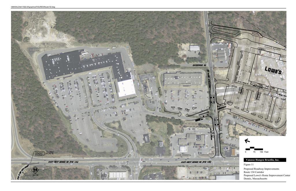
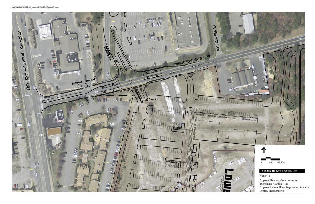
44 Table 8 Trip Reduction Requirement Calculation Daily Trip Generation* 12.5% Reduction Requirement Estimated 7% TDM Credit Shortfall (Assuming 7% TDM Success) Monetary Contribution 4, $358,900 * Based on trip generation projections summarized in Table 3. Please refer to the Appendix for the detailed trip generation calculations. vpd = vehicles per day As shown in Table 8, the transit equivalency calculation results in a monetary contribution of $358,900 to offset the shortfall in the trip reduction requirement. Intersection/Roadway Safety Mitigation It is recognized that operations of the intersection of will degrade slightly between the No-Build and Build conditions at certain study area locations. The following text summarizes future conditions operations and measures proposed by the proponent to address impacts within the study area. Figure 11 shows proposed improvements along the Route 134 corridor and Figure 12 shows proposed improvements along Theophilus F. Smith Road. Intersections Route 134 at Theophilus F. Smith Road Under 2018 No Build conditions, this intersection is expected to operate at LOS C during both the weekday evening and Saturday midday peak hours. Under 2018 Build conditions with the proposed project in place, this intersection is expected to operate at LOS E during the weekday evening peak hour and LOS F during the Saturday midday peak hour. As such, improvements have been proposed at the intersection to accommodate the future traffic volumes. The improvements include changing the lane assignment along the TFS Road approach to an exclusive left-turn lane and a shared left-turn/right-turn lane. The length of the two-lane section will also be extended by approximately 100 feet. Optimization of the traffic signal timing, phasing, and cycle length are also proposed. The results of this analysis are shown in Table 9 and generally indicate that these measures will bring operations to acceptable levels (LOS B during the weekday evening peak hour and LOS D during the Saturday midday peak hour). The proponent will implement these changes as part of the mitigation for the proposed project. 28 Mitigation
45
46
The Cape Cod Five Cents Savings Bank
 TRAFFIC IMPACT AND ACCESS STUDY The Cape Cod Five Cents Savings Bank Hyannis, Massachusetts PREPARED FOR The Cape Cod Five Cents Savings Bank 19 West Road Orleans, Massachusetts 0263 PREPARED BY 1 Walnut
Gateway Transportation Study
 Gateway Transportation Study Amherst, Massachusetts SUBMITTED TO University of Massachusetts Amherst Town of Amherst SUBMITTED BY Vanasse Hangen Brustlin, Inc. Watertown, Massachusetts March 213 Back of
Total Athletics Cape Cod Proposed Sports Facility
 TRAFFIC IMPACT AND ACCE TUDY Total Athletics Cape Cod Proposed ports Facility Barnstable, Massachusetts PREPARED FOR Mr. Warren Nighan Total Athletics 128 Devon Lane Marston Mills, MA 02648 PREPARED BY
Traffic Impact Analysis Chatham County Grocery Chatham County, NC
 Chatham County Grocery Chatham County, NC TABLE OF CONTENTS 1. INTRODUCTION... 1 1.1. Location and Study Area... 1 1.2. Proposed Land Use and Access... 2 1.3. Adjacent Land Uses... 2 1.4. Existing ways...
TRAFFIC IMPACT STUDY
 TRAFFIC IMPACT STUDY for the GLEN ELLEN COUNTRY CLUB SENIOR RESIDENTIAL REDEVELOPMENT 84 Millis, Massachusetts Prepared by: McMahon Associates, Inc. Prepared for: Toll Brothers, Inc. August 216 DRAFT
INDUSTRIAL BUILDING 1660 COMSTOCK ROAD CITY OF OTTAWA TRANSPORTATION OVERVIEW. Prepared for:
 INDUSTRIAL BUILDING 1660 COMSTOCK ROAD CITY OF OTTAWA TRANSPORTATION OVERVIEW Prepared for: Simluc Contractors Limited 2550 Blackwell Street, Ottawa K1B 5R1 October 18, 2013 113-584 Overview_1.doc D. J.
Traffic Impact Analysis Walton Acres at Riverwood Athletic Club Clayton, NC
 Traffic Impact Analysis Walton Acres at Riverwood Athletic Club Clayton, NC 1. TABLE OF CONTENTS INTRODUCTION...1 1.1. Site Location and Study Area...1 1.2. Proposed Land Use and Site Access...2 1.3.
TRAFFIC IMPACT ANALYSIS
 TRAFFIC IMPACT ANALYSIS FOR THE CHAMPAIGN UNIT#4 SCHOOL DISTRICT PROPOSED HIGH SCHOOL (SPALDING PARK SITE) IN THE CITY OF CHAMPAIGN Final Report Champaign Urbana Urbanized Area Transportation Study 6/24/2014
METHODOLOGY. Signalized Intersection Average Control Delay (sec/veh)
") Chapter 5 Traffic Analysis 5.1 SUMMARY US /West 6 th Street assumes a unique role in the Lawrence Douglas County transportation system. This principal arterial street currently conveys commuter traffic
Chapter 5 Traffic Analysis 5.1 SUMMARY US /West 6 th Street assumes a unique role in the Lawrence Douglas County transportation system. This principal arterial street currently conveys commuter traffic
TRAFFIC IMPACT STUDY And A TRAFFIC SIGNAL WARRANT ANALYSIS FOR A SENIOR LIVING AND APARTMENT DEVELOPMENT
 TRAFFIC IMPACT STUDY And A TRAFFIC SIGNAL WARRANT ANALYSIS FOR A SENIOR LIVING AND APARTMENT DEVELOPMENT DEERFIELD TOWNSHIP, WARREN COUNTY, OHIO Nantucket Circle and Montgomery Road () Prepared for: ODLE
QUICKIE C STORE AND GAS BAR 1780 HERON ROAD OTTAWA, ONTARIO TRANSPORTATION BRIEF. Prepared for:
 QUICKIE C STORE AND GAS BAR 1780 HERON ROAD OTTAWA, ONTARIO TRANSPORTATION BRIEF Prepared for: Quickie Convenience Stores Larny Holdings Ltd. c/o PBC Group April 15, 2015 115-615 Report_1.doc D. J. Halpenny
Traffic Impact and Access Study PROPOSED DURKEE FARM ESTATES. Foster Street Littleton, Massachusetts. Prepared for: Grimes Road, LLC.
 Traffic Impact and Access Study PROPOSED DURKEE FARM ESTATES Foster Street Littleton, Massachusetts Prepared for: Grimes Road, LLC. Westford, MA Prepared by: MDM Transportation Consultants, Inc. 28 Lord
Route 28 West Chatham Roadway Improvements
 Functional Design Report Route 28 Chatham Roadway Improvements Project No. 606596 Prepared for Massachusetts Department of Transportation Town of Chatham, Massachusetts Prepared by Howard/Stein-Hudson
Table of Contents FIGURES TABLES APPENDICES. Traffic Impact Study Hudson Street Parking Garage MC Project No.: A Table of Contents
 Traffic Impact Study Hudson Street Parking Garage MC Project No.: 151714A Table of Contents Table of Contents I. INTRODUCTION... 2 II. EXISTING CONDITIONS... 5 III. 215 EXISTING TRAFFIC CONDITIONS... 6
Shockoe Bottom Preliminary Traffic and Parking Analysis
 Shockoe Bottom Preliminary Traffic and Parking Analysis Richmond, Virginia August 14, 2013 Prepared For City of Richmond Department of Public Works Prepared By 1001 Boulders Pkwy Suite 300, Richmond, VA
Route 28 (South Orleans Road)/Route 39 (Harwich Road)/Quanset Road Intersection
/Route 39 (Harwich Road)/Quanset Road Intersection") TRAFFIC FEASIBILITY STUDY Route 28 (South Orleans Road)/Route 39 (Harwich Road)/Quanset Road Intersection Orleans, Massachusetts Prepared for: Town of Orleans Prepared by: Fay, Spofford & Thorndike, LLC
TRAFFIC FEASIBILITY STUDY Route 28 (South Orleans Road)/Route 39 (Harwich Road)/Quanset Road Intersection Orleans, Massachusetts Prepared for: Town of Orleans Prepared by: Fay, Spofford & Thorndike, LLC
CAPE COD COMMISSION 3225 MAIN STREET P.O. BOX 226 BARNSTABLE, MA (508) Fax (508) Transportation Safety Report
 Fax (508) Transportation Safety Report") CAPE COD COMMISSION 3225 MAIN STREET P.O. BOX 226 BARNSTABLE, MA 02630 (508) 362-3828 Fax (508) 362-3136 2006 Transportation Safety Report Bourne: Otis Rotary Harwich: Route 137/Route 39 Orleans: Route
CAPE COD COMMISSION 3225 MAIN STREET P.O. BOX 226 BARNSTABLE, MA 02630 (508) 362-3828 Fax (508) 362-3136 2006 Transportation Safety Report Bourne: Otis Rotary Harwich: Route 137/Route 39 Orleans: Route
5858 N COLLEGE, LLC N College Avenue Traffic Impact Study
 5858 N COLLEGE, LLC nue Traffic Impact Study August 22, 2016 Contents Traffic Impact Study Page Preparer Qualifications... 1 Introduction... 2 Existing Roadway Conditions... 5 Existing Traffic Conditions...
Traffic Study of Fuller Street, Cady Street, West Street and West Avenue. Final Report
 Traffic Study of Fuller Street, Cady Street, West Street and West Avenue Final Report July 2005 Prepared for: Town of Ludlow Prepared by: Pioneer Valley Planning Commission 26 Central Street West Springfield,
THIS PAGE LEFT BLANK INTENTIONALLY
 GA SR 25 Spur at Canal Road Transportation Impact Analysis PREPARED FOR GLYNN COUNTY, GEORGIA 1725 Reynolds Street, Suite 300 Brunswick, Georgia 31520 PREPARED BY 217 Arrowhead Boulevard Suite 26 Jonesboro,
Walmart (Store # ) 60 th Street North and Marion Road Sioux Falls, South Dakota
 60 th Street North and Marion Road Sioux Falls, South Dakota") Walmart (Store #4865-00) 60 th Street North and Marion Road Sioux Falls, South Dakota Prepared for: Wal-Mart Stores, Inc. Bentonville, Arkansas Prepared by: Kimley-Horn and Associates, Inc. ã2013 Kimley-Horn
Walmart (Store #4865-00) 60 th Street North and Marion Road Sioux Falls, South Dakota Prepared for: Wal-Mart Stores, Inc. Bentonville, Arkansas Prepared by: Kimley-Horn and Associates, Inc. ã2013 Kimley-Horn
Transportation Impact Study for Abington Terrace
 Transportation Impact Study for Abington Terrace Abington Township, Montgomery County, PA Sandy A. Koza, P.E., PTOE PA PE License Number PE059911 Prepared by McMahon Associates, Inc. 425 Commerce Drive,
TRANSPORTATION ANALYSIS REPORT US Route 6 Huron, Erie County, Ohio
 TRANSPORTATION ANALYSIS REPORT US Route 6 Huron, Erie County, Ohio December 12, 2012 Prepared for: The City of Huron 417 Main Huron, OH 44839 Providing Practical Experience Technical Excellence and Client
ALLEY 24 TRAFFIC STUDY
 ALLEY 24 TRAFFIC STUDY in City of Frostburg, Maryland January 2013 3566 Teays Valley Road Hurricane, WV Office: (304) 397-5508 www.denniscorporation.com Alley 24 Traffic Study January 2013 Frostburg, Maryland
Technical Memorandum TRAFFIC IMPACT STUDY. RIDLEY ROAD CONVENIENCE STORE Southampton County, VA. Prepared for: Mr. David Williams.
 Technical Memorandum TRFFIC IMPCT STUDY RIDLEY ROD CONVENIENCE STORE Southampton County, V Prepared for: Mr. David Williams By: Charles Smith, P.E., PTOE EPR Charlottesville, V July 2014 1 TBLE OF CONTENTS
Capital Region Council of Governments
 March 23, 2018 Capital Region Council of Governments PROJECT CONCEPT REPORT Realignment of Swamp and Northfield Road s approaches to Route 44 (Boston Turnpike) Town of Coventry SUMMARY: The Town of Coventry
Evaluation of M-99 (Broad Street) Road Diet and Intersection Operational Investigation
 Road Diet and Intersection Operational Investigation") Evaluation of M-99 (Broad Street) Road Diet and Intersection Operational Investigation City of Hillsdale, Hillsdale County, Michigan June 16, 2016 Final Report Prepared for City of Hillsdale 97 North Broad
Evaluation of M-99 (Broad Street) Road Diet and Intersection Operational Investigation City of Hillsdale, Hillsdale County, Michigan June 16, 2016 Final Report Prepared for City of Hillsdale 97 North Broad
Date: September 7, Project #: Re: Spaulding Youth Center Northfield, NH Property. Traffic Impact Study
 To: Ms. Susan C. Ryan Spaulding Youth Center 72 Spaulding Road Northfield, NH 03276 Date: September 7, 2017 Project #: 52455.00 From: Robin Bousa Director of Transportation Systems Re: Spaulding Youth
Truck Climbing Lane Traffic Justification Report
 ROUTE 7 (HARRY BYRD HIGHWAY) WESTBOUND FROM WEST MARKET STREET TO ROUTE 9 (CHARLES TOWN PIKE) Truck Climbing Lane Traffic Justification Report Project No. 6007-053-133, P 101 Ι UPC No. 58599 Prepared by:
FRONT RANGE CROSSINGS TRAFFIC IMPACT STUDY
 FRONT RANGE CROSSINGS TRAFFIC IMPACT STUDY Prepared for: City of Thornton And Colorado Department of Transportation Prepared by: 11 Blake Street, Suite 2 Denver, Colorado 822 Contact: Brian Bern, PE, PTOE
URBAN QUARRY HEADQUARTERS 2717 STEVENAGE DRIVE CITY OF OTTAWA TRANSPORTATION OVERVIEW. Prepared for: Urban Quarry 4123 Belgreen Drive, Ottawa K1G 3N2
 URBAN QUARRY HEADQUARTERS 2717 STEVENAGE DRIVE CITY OF OTTAWA TRANSPORTATION OVERVIEW Prepared for: Urban Quarry 4123 Belgreen Drive, Ottawa K1G 3N2 February 27, 2014 113-584 Overview_1.doc D. J. Halpenny
Traffic Impact Study. Westlake Elementary School Westlake, Ohio. TMS Engineers, Inc. June 5, 2017
 TMS Engineers, Inc. Traffic Impact Study Westlake Elementary School Westlake, Ohio June 5, 2017 Prepared for: Westlake City Schools - Board of Education 27200 Hilliard Boulevard Westlake, OH 44145 TRAFFIC
INDUSTRIAL BUILDING 3009 HAWTHORNE ROAD CITY OF OTTAWA TRANSPORTATION OVERVIEW REVISED. Prepared for: Canada Inc.
 INDUSTRIAL BUILDING 3009 HAWTHORNE ROAD CITY OF OTTAWA TRANSPORTATION OVERVIEW REVISED Prepared for: 7849648 Canada Inc. Octiober 1, 2015 114-598 Overview_2.doc D. J. Halpenny & Associates Ltd. Consulting
OFFICE/RETAIL DEVELOPMENT 1625 BANK STREET OTTAWA, ONTARIO TRANSPORTATION BRIEF. Prepared for: Canada Inc.
 OFFICE/RETAIL DEVELOPMENT 1625 BANK STREET OTTAWA, ONTARIO TRANSPORTATION BRIEF Prepared for: 9402209 Canada Inc. December 15, 2015 115-625 Report_2.doc D. J. Halpenny & Associates Ltd. Consulting Transportation
MEMORANDUM. DATE March 1, 2012 TO Town of Milton Mark Abbott, Seth Asante, and Efi Pagitsas Boston Region MPO Staff
 MEMORANDUM DATE March 1, 212 TO Town of Milton FROM RE Mark Abbott, Seth Asante, and Efi Pagitsas Boston Region MPO Staff FFY 211 Safety and Operations Analyses at Selected Boston Region MPO Intersections:
Traffic Impact Study WestBranch Residential Development Davidson, NC March 2016
 Traffic Impact Study WestBranch Residential Development Davidson, NC March 216 TRAFFIC IMPACT STUDY FOR THE WestBranch Residential Development LOCATED IN DAVIDSON, NC Prepared For: Lennar Carolinas, LLC
Date: April 4, Project #: Re: A Street/Binford Street Traffic/Intersection Assessment
 To: Peter Cavanaugh General Electric From: David Bohn, PE Ryan White, PE Date: April 4, 217 Project #: 13421. Re: / Traffic/Intersection Assessment Consistent with the Cooperation Agreement between the
Henderson Avenue Mixed-Use Development
 Zoning Case: Z145-3 Traffic Impact Analysis Henderson Avenue Mixed-Use Development Dallas, TX October 26 th, 216 Kimley-Horn and Associates, Inc. Dallas, Texas Project #644827 Registered Firm F-928 Traffic
Harrah s Station Square Casino
 Transportation Analysis Harrah s Station Square Casino Pittsburgh, Pennsylvania Submitted To: City of Pittsburgh and Pennsylvania Gaming Control Board Prepared By: DKS Associates GAI Consultants December
Waterford Lakes Small Area Study
 Waterford Lakes Small Area Study Existing Traffic Conditions PREPARED FOR: ORANGE COUNTY PUBLIC WORKS DEPARTMENT TRAFFIC ENGINEERING DIVISION ORLANDO, FLORIDA PREPARED WITH: INWOOD CONSULTING ENGINEERS
STILLWATER AVENUE CORRIDOR STUDY Old Town, Maine
 Draft Study STILLWATER AVENUE CORRIDOR STUDY Old Town, Maine SUBMITTED TO: BANGOR AREA COMPREHENSIVE TRANSPORTATION SYSTEM SUBMITTED BY: I MAY 23, 2017 DRAFT STILLWATER AVENUE STUDY FINAL REPORT Table
Plymouth Rubber Redevelopment
 TRAFFIC IMPACT AND ACCESS STUDY Plymouth Rubber Redevelopment Canton, Massachusetts PREPARED FOR Canton Holdings, LLC c/o North American Real Estate Management 1 East Oak Hill Drive, Suite 11 Westmont,
TRAFFIC IMPACT STUDY COMPREHENSIVE UPDATE TOWN OF THOMPSON S STATION, TENNESSEE PREPARED FOR: THE TOWN OF THOMPSON S STATION
 TRAFFIC IMPACT STUDY COMPREHENSIVE UPDATE TOWN OF THOMPSON S STATION, TENNESSEE PREPARED FOR: THE TOWN OF THOMPSON S STATION Transportation Consultants, LLC 1101 17 TH AVENUE SOUTH NASHVILLE, TN 37212
6060 North Central Expressway Mixed-Use Site Dallas, Texas
 Volume 1 Traffic Impact Analysis 6060 North Central Expressway Mixed-Use Site Dallas, Texas April 30, 2018 Kimley-Horn and Associates, Inc. Dallas, Texas Project #063238300 Registered Firm F-928 Traffic
 TRAFFIC IMPACT STUDY CANYON HILLS PROJECT LOS ANGELES, CALIFORNIA INTRODUCTION This traffic analysis has been conducted to identify and evaluate the potential traffic impacts of the proposed Canyon Hills
MEETING FACILITY 2901 GIBFORD DRIVE CITY OF OTTAWA TRANSPORTATION BRIEF. Prepared for: Holiday Inn Express 2881 Gibford Drive Ottawa, ON K1V 2L9
 MEETING FACILITY 2901 GIBFORD DRIVE CITY OF OTTAWA TRANSPORTATION BRIEF Prepared for: Holiday Inn Express 2881 Gibford Drive Ottawa, ON K1V 2L9 December 18, 2012 112-566 Brief_1.doc D. J. Halpenny & Associates
1609 E. FRANKLIN STREET HOTEL TRAFFIC IMPACT STUDY EXECUTIVE SUMMARY
 1609 E. FRANKLIN STREET HOTEL TRAFFIC IMPACT STUDY EXECUTIVE SUMMARY Prepared for: The Town of Chapel Hill Public Works Department Traffic Engineering Division Prepared by: HNTB North Carolina, PC 343
Figure 1: East West Connector Alignment Alternatives Concept Drawing
 Page 2 of 9 Figure 1: East West Connector Alignment Alternatives Concept Drawing The Montebello Drive extension will run north south and connect Wilsonville Road to the Boones Ferry Road to Brown Road
Project Report. South Kirkwood Road Traffic Study. Meadows Place, TX October 9, 2015
 Meadows Place, TX October 9, 2015 Contents 1 Introduction... 1 2 Data Collection... 1 3 Existing Roadway Network... 2 4 Traffic Volume Development... 2 5 Warrant Analysis... 3 6 Traffic Control Alternative
Draft Report. Traffic Impact Study. Superstore, Wal-Mart, and Kent Development. Yarmouth, Nova Scotia. Prepared for
 oad & Traffic Management Road & Traffic Management R Atlantic Traffic Engineering Specialists Draft Report Traffic Impact Study Superstore, Wal-Mart, and Kent Development Yarmouth, Nova Scotia Prepared
Traffic Impact Study. Roderick Place Columbia Pike Thompson s Station, TN. Transportation Group, LLC Traffic Engineering and Planning
 F i s c h b a c h Transportation Group, LLC Traffic Engineering and Planning Traffic Impact Study Roderick Place Columbia Pike Thompson s Station, TN Prepared March 2016 Ms. Gillian L. Fischbach, P.E.,
Magnolia Place. Traffic Impact Analysis. Prepared for: City of San Mateo. Prepared by: Hexagon Transportation Consultants, Inc.
 Magnolia Place Traffic Impact Analysis Prepared for: City of San Mateo Prepared by: Hexagon Transportation Consultants, Inc. Updated January 4, 2010 Table of Contents 1. Introduction...1 2. Existing Conditions...6
COMMERCIAL DEVELOPMENT 2015 ROBERTSON ROAD OTTAWA, ONTARIO TRANSPORTATION BRIEF. Prepared for:
 COMMERCIAL DEVELOPMENT 2015 ROBERTSON ROAD OTTAWA, ONTARIO TRANSPORTATION BRIEF Prepared for: First Bay Properties Inc. 311 Richmond Road, Suite 203 Ottawa, ON K1Z 6X3 August 8, 2017 117-663 Brief_1.doc
2. Existing Conditions
 2. Existing Conditions The existing traffic and parking conditions on the site and the surrounding area were reviewed based on the study methodology in Section 1.2. 2.1 Existing Land Use The portion of
TRAFFIC STUDY GUIDELINES Clarksville Street Department
 TRAFFIC STUDY GUIDELINES Clarksville Street Department 9/1/2009 Introduction Traffic studies are used to help the city determine potential impacts to the operation of the surrounding roadway network. Two
MEDICAL/OFFICE BUILDING 1637 BANK STREET OTTAWA, ONTARIO TRANSPORTATION OVERVIEW. Prepared for:
 MEDICAL/OFFICE BUILDING 1637 BANK STREET OTTAWA, ONTARIO TRANSPORTATION OVERVIEW Prepared for: 2434984 Ontario Inc. 13-5510 Canotek Road Ottawa, Ontario K1J 9J5 June 4, 2015 115-613 Report_2.doc D. J.
December 4, Merrimac Zoning Board of Appeals 2-8 School Street Merrimac, MA Attn: Kathy Marshall. Dear Board Members:
 December 4, 28 Merrimac Zoning Board of Appeals 2-8 School Street Merrimac, MA 86 Attn: Kathy Marshall RE: RAMSHEAD MERRIMAC, MA Dear Board Members: Bayside Engineering, Inc. has received the MDM Transportation
Glenn Avenue Corridor Traffic Operational Evaluation
 Glenn Avenue Corridor Traffic Operational Evaluation PREPARED FOR: THE CITY OF AUBURN PREPARED BY: DECEMBER 2007 Glenn Avenue Corridor Study--Auburn, Alabama TABLE OF CONTENTS Introduction... 1 Background
EXECUTIVE SUMMARY. Page 1 of 6
 EXECUTIVE SUMMARY The purpose of this report is to identify conformance with the original traffic impact study for the proposed retail development on Lot 5 of Riverdale Retail Filing No. 1 located on the
OTTAWA TRAIN YARDS PHASE 3 DEVELOPMENT CITY OF OTTAWA TRANSPORTATION IMPACT STUDY. Prepared for:
 OTTAWA TRAIN YARDS PHASE 3 DEVELOPMENT CITY OF OTTAWA TRANSPORTATION IMPACT STUDY Prepared for: The Ottawa Train Yards Inc. 223 Colonnade Road South, Suite 212 Nepean, Ontario K2E 7K3 January 17, 2012
DUNBOW ROAD FUNCTIONAL PLANNING
 DUNBOW ROAD FUNCTIONAL PLANNING Final Report August 3, 216 #31, 316 5th Avenue NE Calgary, AB T2A 6K4 Phone: 43.273.91 Fax: 43.273.344 wattconsultinggroup.com Dunbow Road Functional Planning Final Report
HILTON GARDEN INN HOTEL HOTEL EXPANSION 2400 ALERT ROAD, OTTAWA TRANSPORTATION BRIEF. Prepared for:
 HILTON GARDEN INN HOTEL HOTEL EXPANSION 2400 ALERT ROAD, OTTAWA TRANSPORTATION BRIEF Prepared for: Bona Building & Management Co. Ltd. Place Vanier, 333 North River Road Vanier, Ontario K1L 8B9 October
Water Street Corridor Streetscape TRAFFIC STUDY
 TRAFFIC STUDY November 12, 2015 WATER STREET CORRIDOR STREETSCAPE IMPROVEMENTS PROJECT BOROUGH OF MANHATTAN EDC Contract No.: 48480002 Prepared for: Prepared by: TABLE OF CONTENTS I. INTRODUCTION/ EXECUTIVE
Traffic Circulation Study for Neighborhood Southwest of Mockingbird Lane and Airline Road, Highland Park, Texas
 ARIZONA TEXAS NEW MEXICO OKLAHOMA February 13, 2015 Mr. Meran Dadgostar P.E., R.S. Town of Highland Park 4700 Drexel Dr. Highland Park, Texas 75205 Re: Traffic Circulation Study for Neighborhood Southwest
Deer Street Parking Garage & Deer Street Associates Development
 Traffic Impact and Access Study Deer Street Parking Garage & Deer Street Associates Development Portsmouth, New Hampshire Submitted to: City of Portsmouth, New Hampshire 1 Junkins Avenue Portsmouth, New
MIT Kendall Square Initiative
 MIT Kendall Square Initiative Volume II: Technical Studies and Information (NoMa Project and SoMa Project) Final Development Plan Submission Cambridge Planning Board #302 and #303 November 5, Submitted
Traffic Impact & Access Study. Proposed Putnam Pike Commercial Development Smithfield, Rhode Island. Prepared For. Town of Smithfield, Rhode Island
 Traffic Impact & Access Study Proposed Putnam Pike Commercial Development Smithfield, Rhode Island Prepared For Town of Smithfield, Rhode Island February 212 Traffic Impact & Access Study Proposed Putnam
Traffic Impact and Access Study. The Preserve at Abbyville Proposed 40B Residential Development. Norfolk, Massachusetts
 Traffic Impact and Access Study The Preserve at Abbyville Proposed 40B Residential Development Norfolk, Massachusetts Prepared for DiPlacido Development Corp. April 2017 Prepared by GREEN INTERNATIONAL
M-58 HIGHWAY ACCESS MANAGEMENT STUDY Mullen Road to Bel-Ray Boulevard. Prepared for CITY OF BELTON. May 2016
 M-58 HIGHWAY ACCESS MANAGEMENT STUDY Prepared for CITY OF BELTON By May 2016 Introduction Missouri State Highway 58 (M-58 Highway) is a major commercial corridor in the City of Belton. As development has
TRANSPORTATION IMPACT STUDY PROPOSED RIVERFRONT 47 MIXED USE DEVELOPMENT
 November 2016 TRANSPORTATION IMPACT STUDY PROPOSED RIVERFRONT 47 MIXED USE DEVELOPMENT & Aspinwall Borough, Sharpsburg Borough & O Hara Township, Allegheny County, Pennsylvania Prepared for: Riverfront
FAIRFIELD INN & SUITES HOTEL 135 THAD JOHNSON PRIVATE OTTAWA TRANSPORTATION BRIEF. Prepared for:
 FAIRFIELD INN & SUITES HOTEL 135 THAD JOHNSON PRIVATE OTTAWA TRANSPORTATION BRIEF Prepared for: Bona Building & Management Co. Ltd. Place Vanier, 333 North River Road Vanier, Ontario K1L 8B9 August 12,
PINESTONE TRAFFIC IMPACT STUDY Travelers Rest, South Carolina
 PINESTONE TRAFFIC IMPACT STUDY Travelers Rest, South Carolina Prepared for Longbranch Development Prepared by January 13, 219 ii Table of Contents Subject Page Signature Page... i Table of Contents...
Troutbeck Farm Development
 Troutbeck Farm Development Willistown Township, Chester County PA For Submission To: Willistown Township Last Revised: October, 4 TPD# INLM.A. 5 E. High Street Suite 65 Pottstown, PA 9464 6.36.3 TPD@TrafficPD.com
TRAFFIC IMPACT STUDY CRITERIA
 Chapter 6 - TRAFFIC IMPACT STUDY CRITERIA 6.1 GENERAL PROVISIONS 6.1.1. Purpose: The purpose of this document is to outline a standard format for preparing a traffic impact study in the City of Steamboat
4. ENVIRONMENTAL IMPACT ANALYSIS 9. TRANSPORTATION AND TRAFFIC
 4. ENVIRONMENTAL IMPACT ANALYSIS 9. TRANSPORTATION AND TRAFFIC 4.9.1 INTRODUCTION The following section addresses the Proposed Project s impact on transportation and traffic based on the Traffic Study
D.13 Transportation and Traffic
 This section addresses transportation and traffic issues and impacts related to the Proposed Project. Section D.13.1 provides a description of the affected environment for the Proposed Project. Applicable
List of Attachments. Location Map... Site Plan... City of Lake Elsinore Circulation Element... City of Lake Elsinore Roadway Cross-Sections...
 List of Attachments Exhibits Location Map... Site Plan... City of Lake Elsinore Circulation Element... City of Lake Elsinore Roadway Cross-Sections... Existing Lane Geometry and Traffic Controls... Existing
APPENDIX D. Traffic Impact Study Creighton Manning Engineering, LLP
 APPENDIX D Traffic Impact Study Creighton Manning Engineering, LLP Traffic Impact Study Catskill Access Evaluation NYS Thruway Exit 21 Town of Catskill, New York CM Project No. 114-232 Prepared For: Greene
DEPARTMENT OF ENVIRONMENTAL SERVICES. North Harrison Street (Lee Highway to Little Falls Road) Comparative Analysis. Prepared for:
 Comparative Analysis. Prepared for:") DEPARTMENT OF ENVIRONMENTAL SERVICES North Harrison Street (Lee Highway to Little Falls Road) Comparative Analysis Prepared for: Arlington County Department of Environmental Services 2100 Clarendon Boulevard,
DEPARTMENT OF ENVIRONMENTAL SERVICES North Harrison Street (Lee Highway to Little Falls Road) Comparative Analysis Prepared for: Arlington County Department of Environmental Services 2100 Clarendon Boulevard,
Chapter 4 Traffic Analysis
 Chapter 4 Traffic Analysis PURPOSE The traffic analysis component of the K-68 Corridor Management Plan incorporates information on the existing transportation network, such as traffic volumes and intersection
TRAFFIC IMPACT ANALYSIS OF PROPOSED CHESTNUT HILL COLLEGE MASTER PLAN DEVELOPMENT
 TRAFFIC IMPACT ANALYSIS OF PROPOSED CHESTNUT HILL COLLEGE MASTER PLAN DEVELOPMENT Prepared by Orth-Rodgers & Associates, Inc. December 14, 2009 Updated November 9, 2010 230 South Broad Street Philadelphia
MEMORANDUM. Charlotte Fleetwood, Transportation Planner
 MEMORANDUM Date: Updated August 22, 2017 To: Organization: Charlotte Fleetwood, Transportation Planner Boston Transportation Department From: Jason DeGray, P.E., PTOE, Regional Director of Engineering
133 rd Street and 132 nd /Hemlock Street 132 nd Street and Foster Street MINI ROUNDABOUTS. Overland Park, Kansas
 133 rd Street and 132 nd /Hemlock Street 132 nd Street and Foster Street MINI ROUNDABOUTS Overland Park, Kansas September 1, 2017 TABLE OF CONTENTS 1. INTRODUCTION... 1 2. LITERATURE REVIEW... 1 3. CONCEPT
Appendix C. NORTH METRO STATION AREA TRAFFIC IMPACT STATEMENT 88th Avenue Station
 Appendix C NORTH METRO STATION AREA TRAFFIC IMPACT STATEMENT 88th Avenue Station Prepared for: Regional Transportation Department and URS Corporation as part of the North Metro EIS David Evans and Associates,
FINAL Albertville Business Park AUAR Update Traffic Study
 FINAL Albertville Business Park AUAR Update Traffic Study Prepared for City of Albertville, MN July 20, 2017 SRF No. 10060.00 Table of Contents Introduction... 1 Existing Conditions... 1 Data Collection...
FINAL DESIGN TRAFFIC TECHNICAL MEMORANDUM
 FINAL DESIGN TRAFFIC TECHNICAL MEMORANDUM July 2014 FINAL (SR 43) Project Development and Environment Study From State Road 60 (Adamo Drive) to I-4 (SR 400) Hillsborough County, Florida Work Program Item
TRAFFIC ASSESSMENT River Edge Colorado
 TRAFFIC ASSESSMENT River Edge Colorado Submitted by: Fehr & Peers 621 17th Street, Ste. 231 Denver, CO 8293 (33) 296-43 December, 21 App. M-2 Traffic Assessment River Edge Colorado December 21 TABLE OF
Subject: Solberg Avenue / I-229 Grade Separation: Traffic Analysis
 MEMORANDUM Transportation Bill Troe, AICP Jason Carbee, AICP 12120 Shamrock Plaza Suite 300 Omaha, NE 68154 (402) 334-8181 (402) 334-1984 (Fax) To: Project File Date: Subject: Solberg Avenue / I-229 Grade
APARTMENT BUILDING DEVELOPMENT 1161 HERON ROAD OTTAWA, ONTARIO TRANSPORTATION IMPACT STUDY. Prepared for:
 APARTMENT BUILDING DEVELOPMENT 1161 HERON ROAD OTTAWA, ONTARIO TRANSPORTATION IMPACT STUDY Prepared for: 1649362 Ontario Inc. c/o Manor Park Management 231 Brittany Drive, Suite D Ottawa ON K1K 0R8 July
NEW YORK CENTRAL PARK SUBDIVISION BLAIS STREET/ST-PIERRE STREET EMBRUN, ONTARIO TRAFFIC IMPACT STUDY. Prepared for:
 NEW YORK CENTRAL PARK SUBDIVISION BLAIS STREET/ST-PIERRE STREET EMBRUN, ONTARIO TRAFFIC IMPACT STUDY Prepared for: Solidex Holdings Limited & Investissement Maurice Lemieux Investments Attn: Mr. Anthony
Clay Street Realignment Project Traffic Study
 Final Clay Street Realignment Project Traffic Study November 24, 2009 Prepared for: City of Placerville RS07-2466 2990 Lava Ridge Court, Suite 200 Roseville, CA 95661 (916) 773-1900 Fax (916) 773-2015
DIMARCO CANANDAIGUA PROPERTIES HOUSING PROJECT CANANDAIGUA, ONTARIO COUNTY, NEW YORK
 TRAFFIC IMPACT STUDY FOR THE DIMARCO CANANDAIGUA PROPERTIES HOUSING PROJECT CANANDAIGUA, ONTARIO COUNTY, NEW YORK MARCH 14, 2017 PREPARED FOR: 1950 Brighton Henrietta Town Line Rd Rochester, NY 14623 PREPARED
Bridge Street Corridor Study Report
 Bridge Street Corridor Study Report Prepared for: Prepared by: BRIDGE STREET CORRIDOR STUDY REPORT PREPARED FOR: CITY OF ARROYO GRANDE COMMUNITY DEVELOPMENT DEPARTMENT 300 EAST BRANCH STREET ARROYO GRANDE,
HOLIDAY INN HOTEL 235 KING EDWARD AVENUE CITY OF OTTAWA TRANSPORTATION BRIEF. Prepared for:
 HOLIDAY INN HOTEL 235 KING EDWARD AVENUE CITY OF OTTAWA TRANSPORTATION BRIEF Prepared for: Momentum Planning & Communications 1165 Greenlawn Crescent Ottawa, ON K1L 6C2 June 29, 2015 115-618 Brief_1.doc
TRANSPORTATION IMPACT ASSESSMENT
 TRANSPORTATION IMPACT ASSESSMENT PARKSIDE APARTMENTS AND CONDOMINIUMS 383-385 WASHINGTON STREET BRAINTREE, MASSACHUSETTS Prepared for: 383 WASHINGTON STREET, LLC Boston, Massachusetts February 217 Prepared
APPENDIX E: Transportation Technical Report
 New Jersey Pennsylvania Lackawanna Cut-Off Passenger Rail Service Reston Project Environmental Assessment APPENDIX E: Transportation Technical Report E.1 Introduction As part of the overall environmental
Abrams Associates. Transportation Impact Analysis. City of Rocklin. Prepared for: David Mohlenbrok City of Rocklin 4081 Alvis Court Rocklin, CA 95677
 Transportation Impact Analysis Sierra College Boulevard Commercial Project City of Rocklin Prepared for: David Mohlenbrok City of Rocklin 081 Alvis Court Rocklin, CA 95677 Prepared by: 1875 Olympic Boulevard,
Traffic Study North Shore School District 112
 Traffic Study North Shore School District 112 Proposed Expansion of Northwood Junior High School Prepared By: May 1, 2015 1. Introduction Kenig, Lindgren, O Hara, Aboona, Inc. (KLOA, Inc.) has been retained
HENDERSON DEVELOPMENT 213, 217, 221, 221 ½, 223 HENDERSON AVENUE and 65 TEMPLETON STREET OTTAWA, ONTARIO TRANSPORTATION OVERVIEW.
 HENDERSON DEVELOPMENT 213, 217, 221, 221 ½, 223 HENDERSON AVENUE and 65 TEMPLETON STREET OTTAWA, ONTARIO TRANSPORTATION OVERVIEW Prepared for: 2294170 Ontario Inc. February 2, 2017 117-652 Report_1.doc
Traffic Analysis and Design Report. NW Bethany Boulevard. NW Bronson Road to NW West Union Road. Washington County, Oregon
 Traffic Analysis and Design Report NW Bethany Boulevard NW Bronson Road to NW West Union Road Washington County, Oregon May 2011 Table of Contents Table of Contents Section 1 Executive Summary... 2 Section