APPENDIX D. Traffic Impact Study Creighton Manning Engineering, LLP
|
|
|
- Eugenia Marsh
- 5 years ago
- Views:
Transcription
1 APPENDIX D Traffic Impact Study Creighton Manning Engineering, LLP

2 Traffic Impact Study Catskill Access Evaluation NYS Thruway Exit 21 Town of Catskill, New York CM Project No Prepared For: Greene County IDA 270 Mansion Street Coxsackie, New York Prepared By: December 21, Winners Circle Albany, New York (518)
3 Table of Contents Page Title Page... i Table of Contents... ii List of Figures... iii List of Tables... iii List of Appendices... iv CHAPTER I. INTRODUCTION... 1 A. Planned Project... 1 B. Study Area and Methodology... 2 CHAPTER II. EXISTING CONDITIONS... 4 A. Roadway Serving the Site... 4 B. Study Area Intersections... 4 C. Existing Conditions... 5 D. Multi-Modal Accommodations... 6 CHAPTER III. TRAFFIC FORECASTS... 8 A No-Build Traffic Volumes... 8 B. Trip Generation... 8 C. Trip Distribution D. Trip Assignment E Build Traffic Volumes CHAPTER IV. ANALYSIS A. Sight Distance Analysis B. Capacity/Level of Service Analysis C. Multi-Modal D. Sensitivity Evaluation CHAPTER V. CONCLUSIONS AND RECOMMENDATIONS ii
4 List of Figures Figure 2.1 Existing PM Peak Hour Traffic Volumes... 7 Figure No-Build PM Peak Hour Traffic Volumes Figure 3.2 Trip Distribution Figure 3.3 PM Peak Hour Trip Assignment Figure Build PM Peak Hour Traffic Volumes Figure 4.1 Concept Plan Figure 4.2 PM Peak Hour Alternate 1 Trip Assignment Figure Build Alternate 1 PM Peak Hour Traffic Volumes List of Tables Table 1.1 Alternate Land Use Developments... 2 Table 3.1 Trip Generation Summary... 9 Table 4.1 Sight Distance Summary (feet) Table 4.2 PM Peak Hour Level of Service Summary Table PM Peak Hour Level of Service Summary List of Appendices Appendix A... Development Scenario Alternates Appendix B... Turning Movement Counts Appendix C... Detailed Trip Generation Estimates Appendix D... Level of Service Analysis iii
5 CHAPTER I INTRODUCTION This report summarizes the results of a Traffic Impact Study (TIS) completed for a proposed multi-use development located in the Town of Catskill, Greene County, New York. The project site includes approximately 60 developable acres located on the west side of the NYS Thruway (I-87) bordered by Main Street (County Road(CR) 23B) to the north and NY Route 23 to the south. The purpose of the traffic evaluation is to determine potential traffic impacts and identify off-site mitigation needed with the proposed development. A. Planned Project Four development scenarios are currently under consideration for construction to be completed by The four alternate land use development plans are included in Appendix A and are summarized in Table 1.1. Access to the site will be via Main Street and is the same for all of the development scenarios with primary access across from Forest Hill Avenue and a secondary access approximately 550-feet west. A third driveway for emergency access only is proposed to the east of the primary access driveway adjacent to the NYS Thruway. Construction of the proposed project includes the removal of five existing homes and an automotive business. This traffic evaluation includes a trip generation estimate for four development alternates for the weekday PM Peak hour and a detailed traffic evaluation for the alternate with the highest peak hour trip generating potential. A sensitivity analysis will also be completed for the preferred development scenario. Catskill Access Evaluation, Town of Catskill, NY Page 1
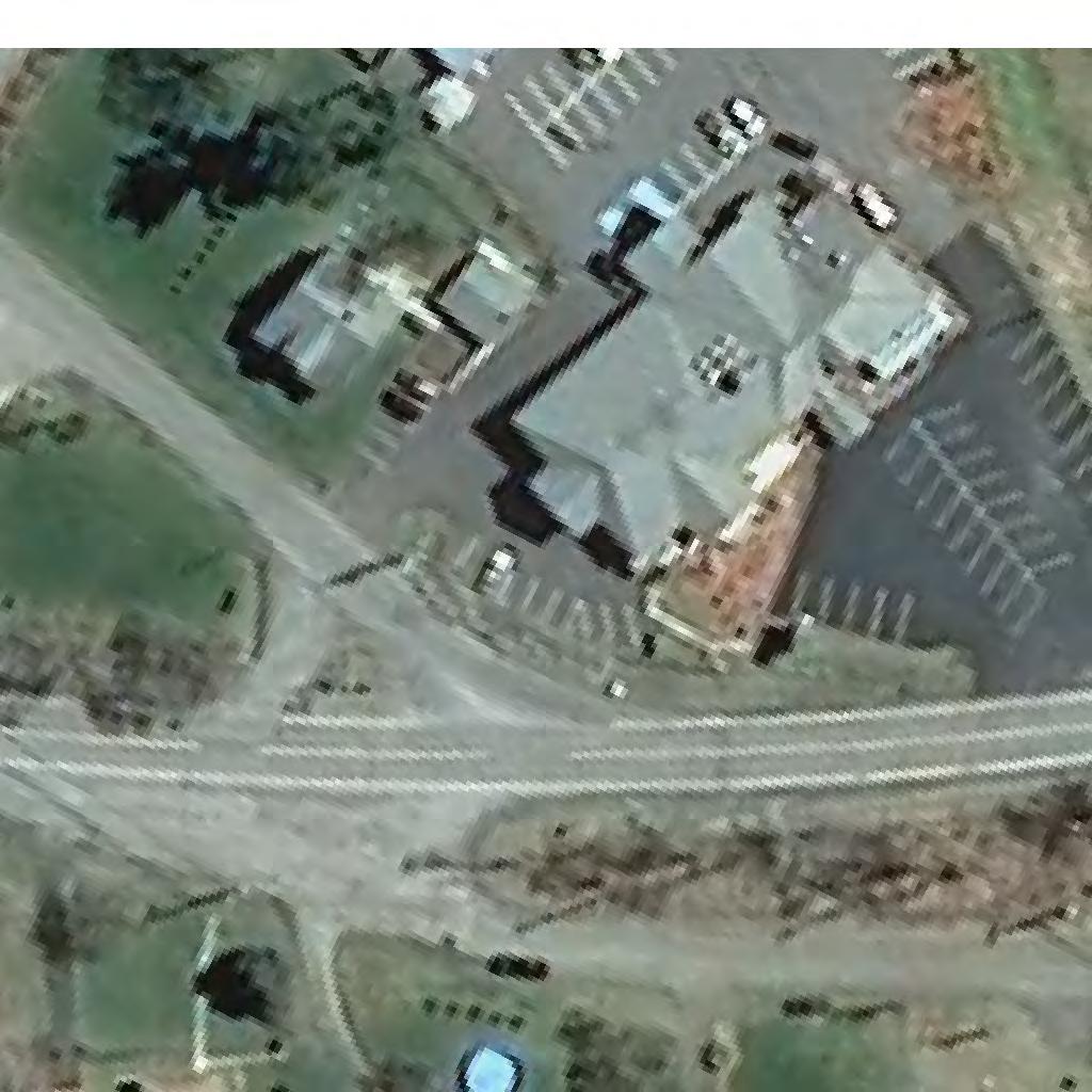
6 Table 1.1 Alternate Land Use Developments Alternate 1 Alternate 2 Water Park/Resort Hotel w/ cabins 425 Rooms Indoor Recreation 130,000 SF Conference Center 20,000 SF Outdoor Adventure Center 4 Acres Hotel 80 Rooms Hotel 80 Rooms Indoor Activity Center 27,500 SF Restaurant 15,000 SF Outdoor Adventure Center 9 Acres Apartments 96 Units Townhouses 60 Units Convenience Store/Gas Station 4,300 SF Alternate 3 Alternate 4 National Brand Retail 82,500 SF Warehouse/Distribution Center 201,250 SF Retail Plaza 13,000 SF Office 159,600 SF Truck Stop 15,000 SF Hotel 80 Rooms Hotel 80 Rooms Restaurant 15,000 SF Restaurant 15,000 SF Apartments 96 Units Apartments 96 Units Townhouses 60 Units Townhouses 60 Units Convenience Store/Gas Station 4,300 SF B. Study Area and Methodology The study area for this analysis was determined based on a review of the surrounding roadway network and an estimate of the project s influence area. The following intersections are included in the study and are illustrated on the following aerial image: Main Street (CR 23B)/NY Route 23 Eastbound Ramps Main Street (CR 23B)/NY Route 23 Westbound Ramps Main Street (CR 23B)/I-87 Exit 21/Oak Street Main Street (CR 23B)/Forest Hills Avenue Main Street (CR 23B)/Cauterskill Road (CR 47) NY Route 23/Cauterskill Road (CR 47) Catskill Access Evaluation, Town of Catskill, NY Page 2
, and determining the operating conditions of the study area intersections and site access after development of the site.")
7 The potential traffic impact of the proposed project was determined by documenting the existing traffic conditions in the area, projecting future traffic volumes (including the peak hour trip generation of the site), and determining the operating conditions of the study area intersections and site access after development of the site. Catskill Access Evaluation, Town of Catskill, NY Page 3
8 CHAPTER II EXISTING CONDITIONS A. Roadway Serving the Site Main Street (CR 23B) Main Street, designated CR 23B, is a county road providing primarily east/west travel through the Towns of Catskill and Cairo. Near the site, Main Street travels in a north/south direction and provides one 12-foot wide travel lane in each direction with three to four foot wide paved shoulders. There are no sidewalks along Main Street and no on street parking is allowed in the study area. The posted speed near the site is 35-mph and land use in the study area is a mix of residential and commercial. B. Study Area Intersections Main Street (CR 23B)/NY Route 23 Eastbound Ramps This four-leg intersection operates under stop sign control on the eastbound off ramp approach to the intersection. The northbound Main Street approach provides a single lane for shared through and right-turn movements, the Main Street southbound approach provides a left-turn lane and a through lane, and the NY Route 23 Eastbound offramp provides a one-way approach wide enough for separate left- and right-turn movements. The eastern leg of the intersection is a one-way on-ramp to NY Route 23 eastbound. There are no sidewalks or marked crosswalks at the intersection. Main Street (CR 23B)/NY Route 23 Westbound Ramps This four-leg intersection operates under stop sign control on the westbound off ramp approach to the intersection. The northbound Main Street approach provides a left-turn lane and a through lane, the southbound approach provides a through lane and a channelized yield-controlled right-turn lane, the westbound NY Route 23 Westbound off-ramp provides a one-way approach wide enough for separate left- and right-turn movements. The western leg of this intersection is a one-way on-ramp to NY Route 23 westbound. There are no sidewalks or marked crosswalks at the intersection. Main Street (CR 23B)/I-87 Exit 21/Oak Street This is a four-leg intersection operating under traffic signal control. The northbound Main Street approach provides a left-turn, through, and channelized yield-controlled right-turn lane. The southbound Main Street approach provides a left-turn lane and a single lane for shared through and right-turn movements. The eastbound Oak Street approach provides a single lane for shared left-turn and through movements and an exclusive right-turn only lane. The westbound I-87 Exit 21 approach provides a single lane for shared left-turn and through movements and a channelized right turn slip lane operating under yield control. There are no sidewalks, marked crosswalks, or pedestrian signals at this intersection. Catskill Access Evaluation, Town of Catskill, NY Page 4
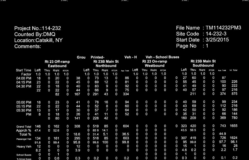
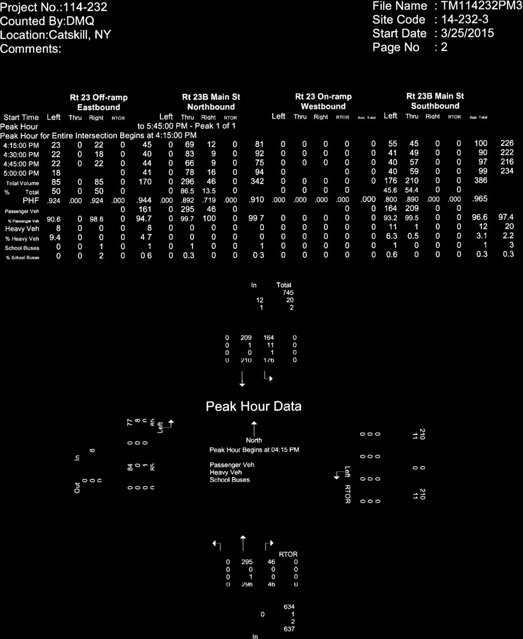
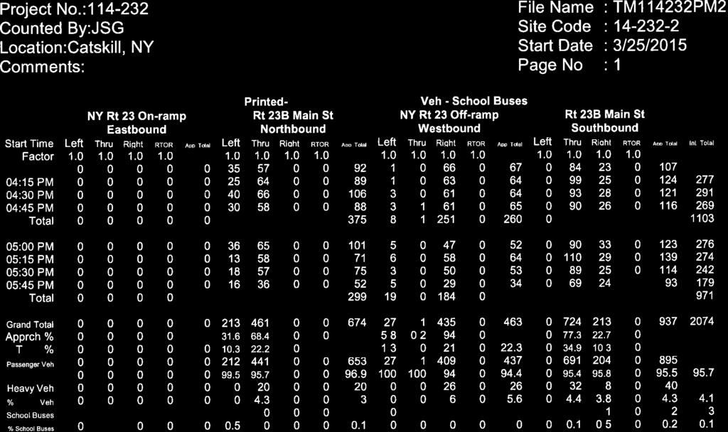
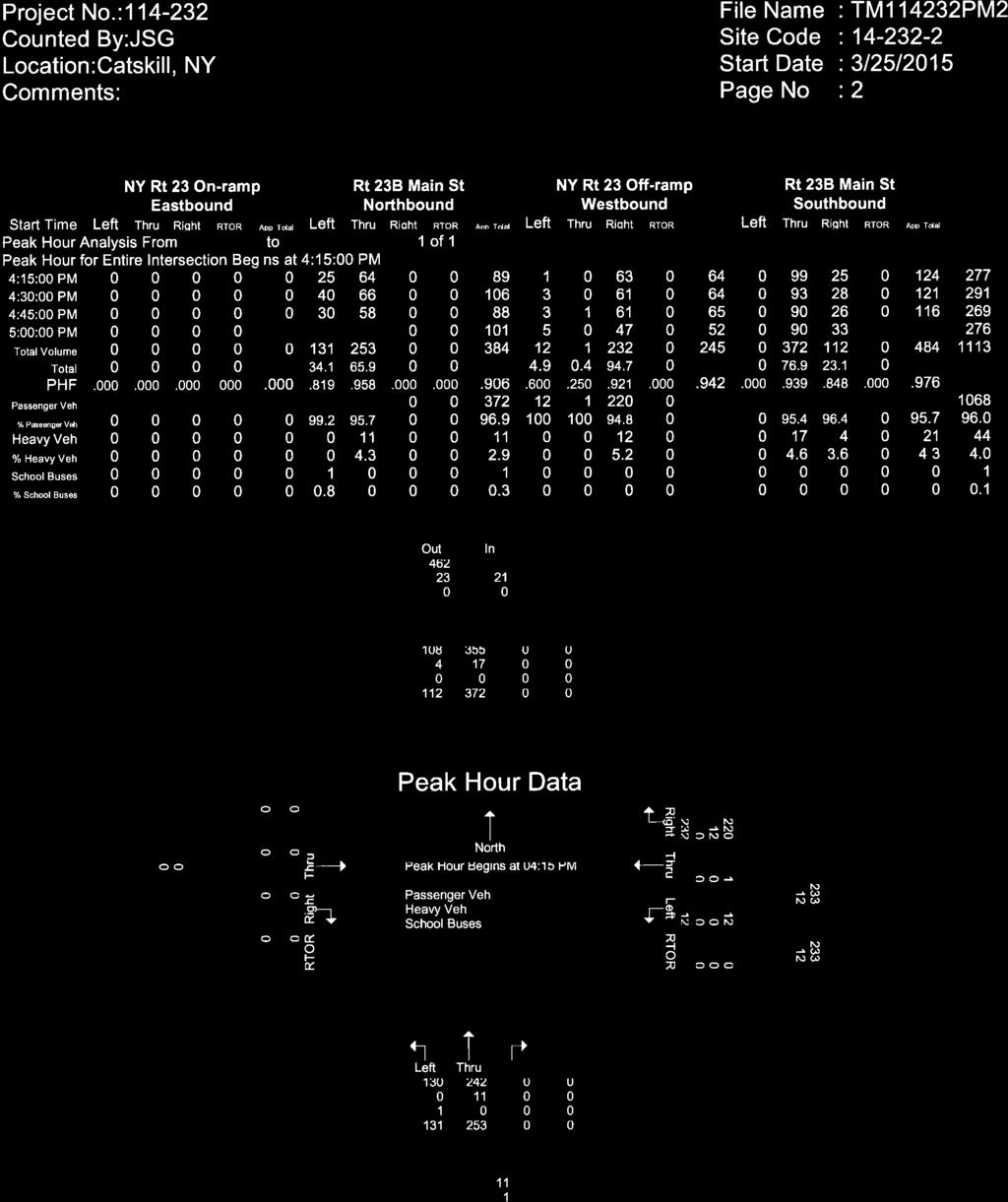
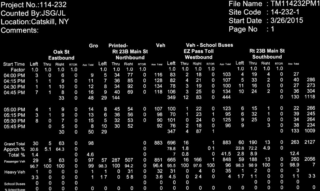
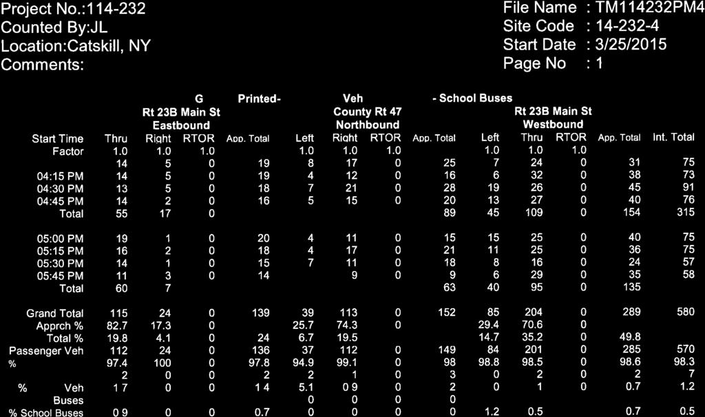
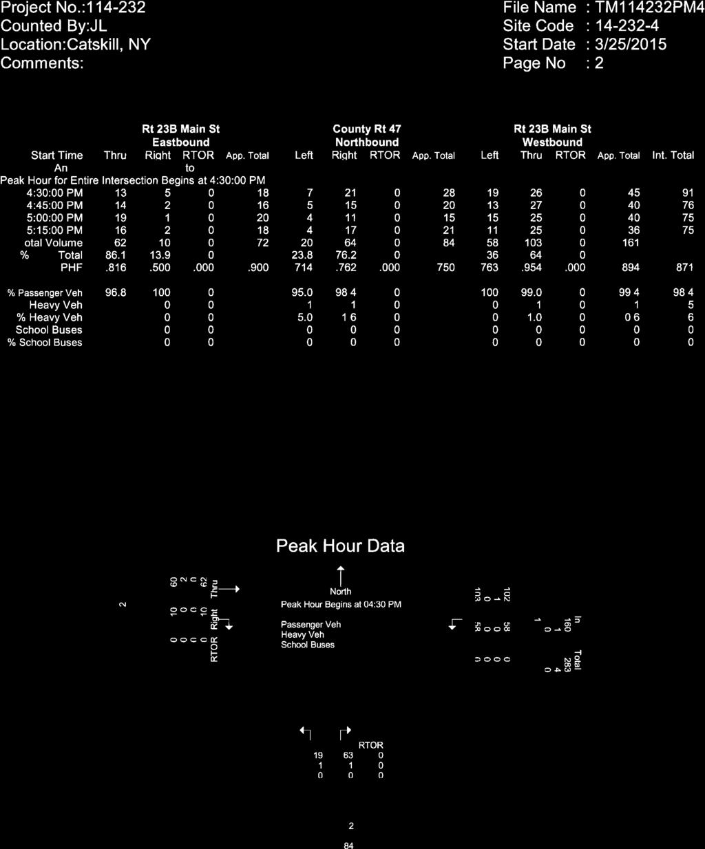
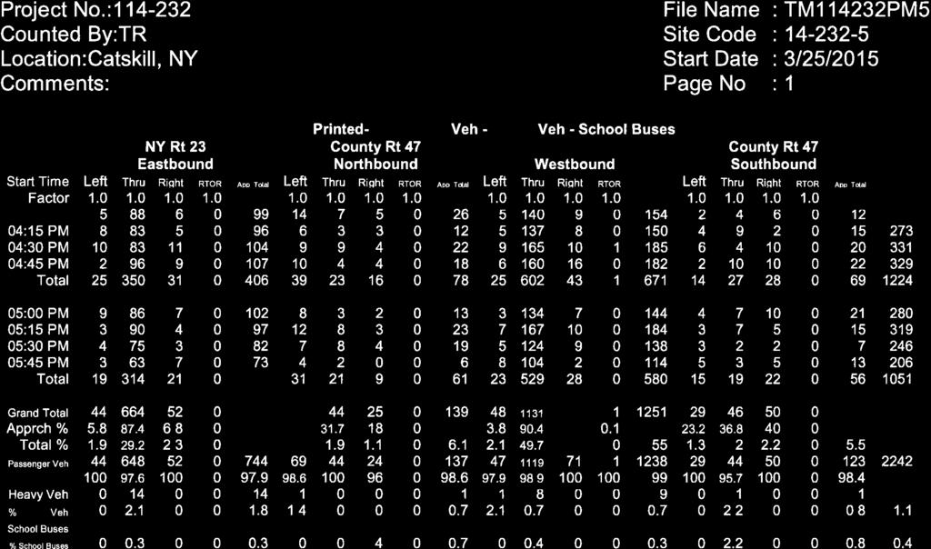
9 Main Street (CR 23B)/Forest Hills Avenue The Main Street approaches to this fourleg intersection provides single lanes for shared travel movements. The southbound Forest Hills Avenue approach splits to provide a channelized stop-controlled rightturn lane (Forest Hills Avenue) and a stop-controlled shared left-turn/through lane (Leeds Road). The northbound approach is a large curb cut that is uncontrolled (however vehicles exiting must yield to Main Street traffic) providing access to a dead end road providing access to several homes. There are no sidewalks or marked crosswalks at the intersection. Main Street (CR 23B)/Cauterskill Road (CR 47) This is a three-leg intersection operating under stop sign control on the northbound Cauterskill Road approach to the intersection. All intersection approaches provide a single lane for shared travel movements. There are no sidewalks or marked crosswalks at the intersection. NY Route 23/Cauterskill Road (CR 47) This is a four-leg intersection operating under traffic signal control. The northbound and southbound Cauterskill Road approaches provide a single lane for shared travel movements. The eastbound NY Route 23 approach provides a left-turn lane, a through lane, and a shared through/right-turn lane. The westbound NY Route 23 approach provides a left-turn lane, two through lanes, and a right-turn lane. The eastbound and westbound travel lanes are separated by a median with guiderail. There are no sidewalks, marked crosswalks, or pedestrian signals at this intersection. C. Existing Conditions This traffic study focuses on the weekday PM peak period to coincide with the peak period for commuter travel on the adjacent roadway network and a peak operating period for the proposed land uses within the development scenarios at the site. Intersection turning movement traffic counts were conducted at the study area intersections on Wednesday and Thursday, March 25 and 26, 2015 from 4:00 to 6:00 p.m. The raw traffic volume data are included in Appendix B. A regression analysis conducted using historical traffic volume data published by NYSDOT along Main Street, NY Route 23, and Cauterskill Road indicates that traffic volume changes range from reductions of 2% per year and increases of 4.6% per year with most roadways showing a reduction in traffic volumes. The 2015 traffic volumes were increased by 0.25% for one year to represent current 2016 conditions and account for growth that may have occurred in the study area since the data collection was completed. These 2016 Existing traffic volumes form the basis for all traffic forecasts and are summarized on Figure 2.1. Catskill Access Evaluation, Town of Catskill, NY Page 5
10 The following observations are evident based on the existing traffic volume data: The PM peak hour generally occurred from 4:15 to 5:15 p.m. The two-way traffic volume on Main Street near the project site is approximately 3,625 vehicles per day (vpd) with 335 vehicles per hour (vph) during the PM peak hour. Heavy vehicles and buses account for approximately one percent of two-way traffic volumes on Main Street during the PM peak hour. D. Multi-Modal Accommodations Transit service in Greene County is provided by the Greene County Transit System. According to the Greene County website, the transit system provides bus service between the Village of Catskill and outlying areas of Greene County. Due to the close proximity of the site to the Village of Catskill, there are multiple routes that pass the site on Main Street including Route 700 (Blue), Route 705 (Green), Route 706 (Brown), and Route 709 (Red) NY Route 385. The study area provides limited pedestrian accommodations as there are no marked crosswalks, sidewalks, or pedestrian signals throughout the study area. During field observations a bicyclist was observed at two intersections and a pedestrian was observed at one intersection. No pedestrians or bicyclists were observed at the other three intersections. Catskill Access Evaluation, Town of Catskill, NY Page 6
11 greene COUNTY greene N b COUNTY Main St Forest Hils Ave 0 Exit OakS t N:\Projects\2014\ Catskil Access Evaluation\cadd\dgn\figures\ _fig_traf_01.dgn NYS Thruway 2016 EXISTING PM PEAK HOUR TRAFFIC VOLUMES CATSKILL ACCESS EVALUATION TOWN OF CATSKILL, NEW YORK Jefferson Heights PROJECT: DATE: 10/2016 FIGURE:
12 CHAPTER III TRAFFIC FORECASTS To evaluate the impact of the proposed development, traffic projections were prepared for 2019, the expected year of site development and operation. A No-Build Traffic Volumes No-Build traffic volumes include background traffic growth and trips associated with other development projects in the study area. Information provided by the Town of Catskill indicates that there are currently no other developments in the study area that will impact traffic volumes at the study area intersections; therefore only a general background growth rate was applied. Consistent with the 2015 raw traffic volumes, the 0.25% growth rate was applied to the 2016 Existing traffic volumes for three years to develop the 2019 No-Build Traffic Volumes as illustrated on Figures 3.1. These volumes represent conditions in the study area expected without development of the proposed project. B. Trip Generation Trip generation determines the quantity of traffic expected to travel to/from the project site. The Institute of Transportation Engineers (ITE) Trip Generation, 9 th edition, provides trip generation data for various land uses based on studies of similar existing developments located across the country. The peak hour trip generation was estimated for all four development scenarios and summarized in Table 3.1. It can be expected that some of the traffic coming to the proposed project will stop at more than one location or be completely internal to the site. These trips are referred to as multi-use or internal trips and are described as trips that use one or more land uses in the same area. For example, a person may visit the convenience store/gas station before travelling to the restaurant for dinner within the mixed use development during a single shared trip to the site. Based on the mix of proposed land uses, it s expected that roadway connections will be provided within the site to allow for internal trips between land uses; therefore, internal Catskill Access Evaluation, Town of Catskill, NY Page 8
13 capture rates were applied to the trip generation estimate for Alternates 2, 3, and 4. To account for the mix of available land uses, the peak hour internal capture rates were completed using the methodology contained in the methodology in NCHRP Report 684 Enhancing Internal Trip Capture Estimation for Mixed-Use Developments. It can also be expected that some trips to the proposed project for Alternates 2, 3, and 4 will originate from traffic that is already passing the site on Main Street. Pass-by trips are vehicles that will stop at the site before continuing on to their primary destination. For example, a person traveling westbound on Main Street may stop at the convenience store/gas station and then continue westbound towards home. This type of trip would be considered a pass-by trip. Pass-by trip percentages were applied to the various land uses based upon data provided by ITE. Table 3.1 summarizes the trip generation for the four Alternates. Detailed trip generation estimates are included in Appendix C. Alternative Land Use Alternate 1 Alternate 2 Alternate 3 Alternate 4 Table 3.1 Trip Generation Summary PM Peak Hour Enter Exit Total Total Trips Multi-Use Trips (0%) Pass-By Trips (0%) Total New Trips Total Trips Multi-Use Trips (-29%) Pass-By Trips (-13%) Total New Trips Total Trips Multi-Use Trips (-38%) Pass-By Trips (-27%) Total New Trips Total Trips Multi-Use Trips (%) Pass-By Trips (%) Total New Trips The trip generation estimate shows that Alternate 3 will generate the fewest number of new peak hour trips and Alternate 2 will generate the highest number of new peak hour trips. Catskill Access Evaluation, Town of Catskill, NY Page 9
14 For the purposes of this study, the land use scenario with the highest trip generation (Alternate 2) will be analyzed further to evaluate the worst case scenario. C. Trip Distribution Trip distribution describes where traffic originates or where traffic is destined. Traffic generated by the proposed project was distributed based on existing travel patterns, the sight design, and the locations of the proposed driveways. Due to the anticipated internal roadway connections at the site, it s expected that the majority of the traffic will use the primary site driveway across from Forest Hill Avenue. This assumption also provides for a worst case evaluation of the primary site driveway intersection. In general, 90% of the site generated traffic will access the site via Main Street across from Forest Hill Avenue at the primary site access and 10% will use the secondary site driveway located approximately 550 feet west. Based on a review of the current travel patterns in the study area and an estimate of the travel patterns for the proposed uses at the site, it is assumed that 15% of the site generated traffic will travel to/from the east, 15% will travel to/from the west, and the remaining 65% will travel to/from the north and south using the NYS Thruway. Pass-by trips were distributed to traffic travelling past the site on Main Street based on the existing travel patterns. All of the development scenarios are expected to use the same distribution pattern. The detailed trip distribution pattern for the proposed site is shown on Figure 3.2. D. Trip Assignment Trip assignment combines the results of the trip generation and trip distribution and determines the specific paths and roadways that will be used between various origin/destination pairs. Pass-by trips were assigned to traffic travelling past the site on Main Street. Figure 3.3 illustrates the trip assignments for the PM peak hour for the worst case development scenario. Catskill Access Evaluation, Town of Catskill, NY Page 10
15 E Build Traffic Volumes The results of the site generated traffic assignment were added to the 2019 No-Build traffic volumes to develop the 2019 Build traffic volumes. The 2019 Build traffic volumes are shown on Figure 3.4. Catskill Access Evaluation, Town of Catskill, NY Page 11
16 greene greene N COUNTY 23b COUNTY Main St Forest Hils Ave Exit OakS t N:\Projects\2014\ Catskil Access Evaluation\cadd\dgn\figures\ _fig_traf_01.dgn NYS Thruway 2019 NO-BUILD PM PEAK HOUR TRAFFIC VOLUMES CATSKILL ACCESS EVALUATION TOWN OF CATSKILL, NEW YORK Jefferson Heights PROJECT: DATE: 10/2016 FIGURE:
17 GREENE 15% 15% greene 15% 15% 15% 65% 15% N 5% 15% 5% 15% 5% 15% 5% 5% 5% 47 COUNTY 23b COUNTY Main St 5% (-30%) 15% (+30%) Forest Hils Ave (+70%) 15% (+30%) 75% (-70%) 5% (+70%) 75% Exit 21 15% 23 OakS t 65% N:\Projects\2014\ Catskil Access Evaluation\cadd\dgn\figures\ _fig_traf_01.dgn NYS Thruway PRIMARY (PASS-BY) TRIP DISTRIBUTION CATSKILL ACCESS EVALUATION TOWN OF CATSKILL, NEW YORK % Jefferson Heights PROJECT: DATE: 10/2016 FIGURE: 3.2

18 GREENE greene N COUNTY 23b COUNTY Main St 12 (-17) 42 (+17) Forest Hils Ave (+40) 34 (+17) 171 (-40) 14 (+40) 211 Exit OakS t 183 N:\Projects\2014\ Catskil Access Evaluation\cadd\dgn\figures\ _fig_traf_01.dgn NYS Thruway PRIMARY (PASS-BY) TRIP ASSIGNMENT CATSKILL ACCESS EVALUATION TOWN OF CATSKILL, NEW YORK Jefferson Heights PROJECT: DATE: 10/2016 FIGURE: 3.3
19 GREENE greene N COUNTY 23b COUNTY Main St Forest Hils Ave Exit OakS t N:\Projects\2014\ Catskil Access Evaluation\cadd\dgn\figures\ _fig_traf_01.dgn NYS Thruway 2019 BUILD PM PEAK HOUR TRAFFIC VOLUMES CATSKILL ACCESS EVALUATION TOWN OF CATSKILL, NEW YORK Jefferson Heights PROJECT: DATE: 10/2016 FIGURE:
20 CHAPTER IV ANALYSIS A. Sight Distance Analysis A sight distance evaluation was completed at the proposed site access intersections with Main Street. Available intersection sight distance was measured from the perspective of a passenger vehicle exiting the site. In addition, the sight distance for vehicles traveling along Main Street looking straight ahead to turn left into the site was measured. The available intersection sight distance on a side street should provide drivers a sufficient view of the intersecting highway to allow vehicles to enter or exit the intersection without excessively slowing vehicles traveling at or near the operating speed on the intersecting mainline. Stopping sight distance was also measured on Main Street at the proposed site access locations. Stopping sight distance is the length of the roadway ahead that is visible to the driver. The available stopping sight distance on a roadway should be of sufficient length to enable a vehicle traveling at or near the operating speed to stop before reaching a stationary object in its path. The following diagram illustrates these sight distance measurements. Intersection Sight Distance Measurements Catskill Access Evaluation, Town of Catskill, NY Page 16
 for a 40-mph operating speed on Main")
21 The posted speed limit on Main Street near the site is 35-mph and the recorded 85 th percentile travel speed is 42-mph. The sight distances measured in the field were compared to the guidelines presented in American Association of State Highway Transportation Officials (AASHTO) for a 40-mph operating speed on Main Street. The results of the sight distance evaluation are summarized in Table 4.1. Intersection Table 4.1 Sight Distance Summary (feet) Right-turn from Site Dwy (looking left) Intersection Sight Distance 1 Stopping Sight Distance 2 Left-turn from Left-turn from Site Dwy 1 Mainline EB WB Looking Looking (looking left right straight) Primary Site Dwy/Main St/Forest Hill Ave Available Recommended Secondary Site Dwy/Main St Available Recommended Intersection sight distance is measured at 14.5 feet back from the travel way at an eye height and object height of 3.5 feet. 2. Stopping sight distance is measured at an eye height of 3.5 feet for a 2-foot object located in the path of vehicles travelling on the mainline. Primary Site Driveway/Main Street/Forest Hill Avenue The sight distance analysis shows that the available sight distances along the site frontage on Main Street meet the AASHTO guidelines for a 40-mph operating speed at the Primary Site Driveway/Forest Hill Avenue intersection. Secondary Site Driveway/Main Street The sight distances available at the secondary site driveway intersection with Main Street meet the AASHTO guidelines for a 40-mph operating speed with the exception of the sight distance looking left to make a left or right-turn out of the site. The sight distance is limited by an embankment as shown in Photograph 1. A review of the criteria in the New York State Supplement to the National Manual of Uniform Traffic Control Devices (NMUTCD) indicates that while the sight distance looking left is less than desirable, it s not critically limited and therefore does not require mitigation such as the installation of an intersection warning sign. However, in order to maximize the sight lines and meet the AASHTO recommended sight distance, it Existing embankment Photograph 1: Sight distance looking left (DL) from Secondary Site Dwy Catskill Access Evaluation, Town of Catskill, NY Page 17
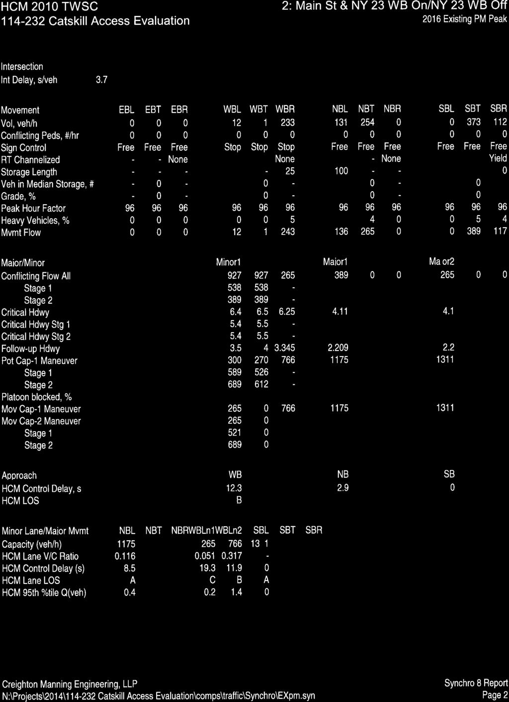
22 is recommended that the site driveway be relocated approximately 100-feet east along the project frontage. B. Capacity/Level of Service Analysis Intersection Level of Service (LOS) and capacity analysis relate traffic volumes to the physical characteristics of an intersection. Intersection evaluations were made using Synchro (Version 8) software which automates the procedures contained in the 2010 Highway Capacity Manual. Levels of service range from A to F with level of service A conditions considered excellent with little delay while level of service F generally represents conditions with long delays. Further detailed information about levels of service criteria is included in Appendix C. Table 4.2 summarizes the results of the Level of Service calculations. The detailed level of service evaluations are included in Appendix C. Catskill Access Evaluation, Town of Catskill, NY Page 18
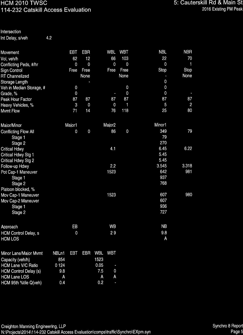
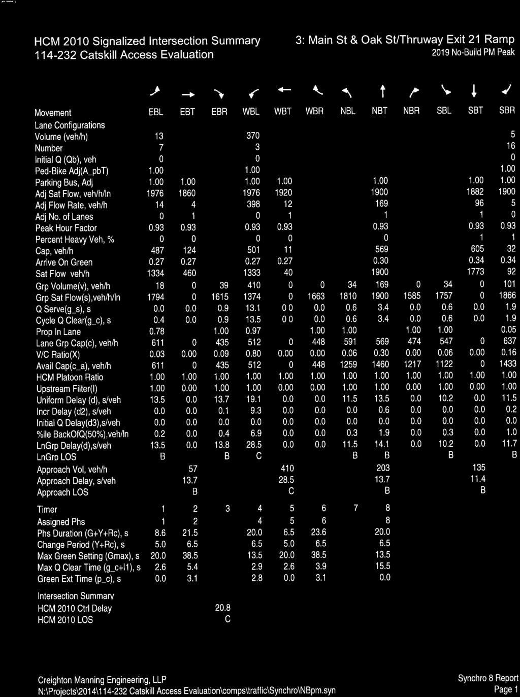
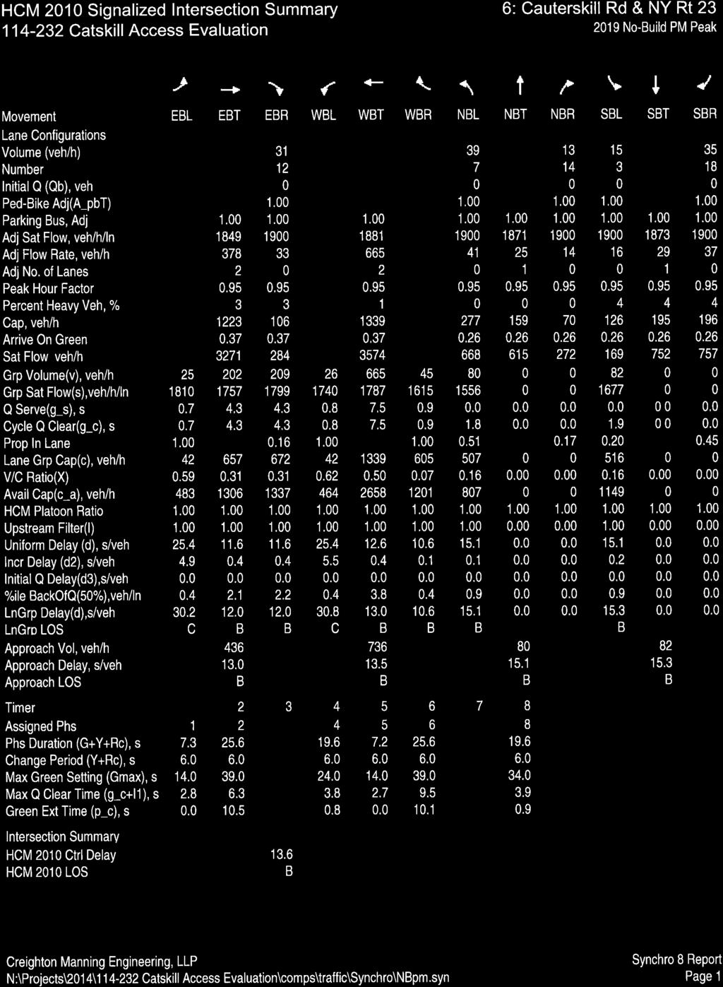
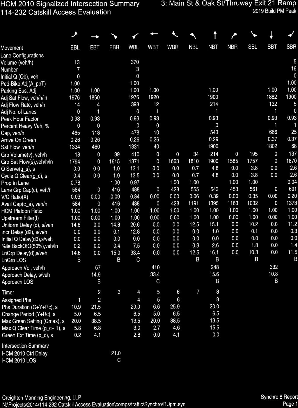
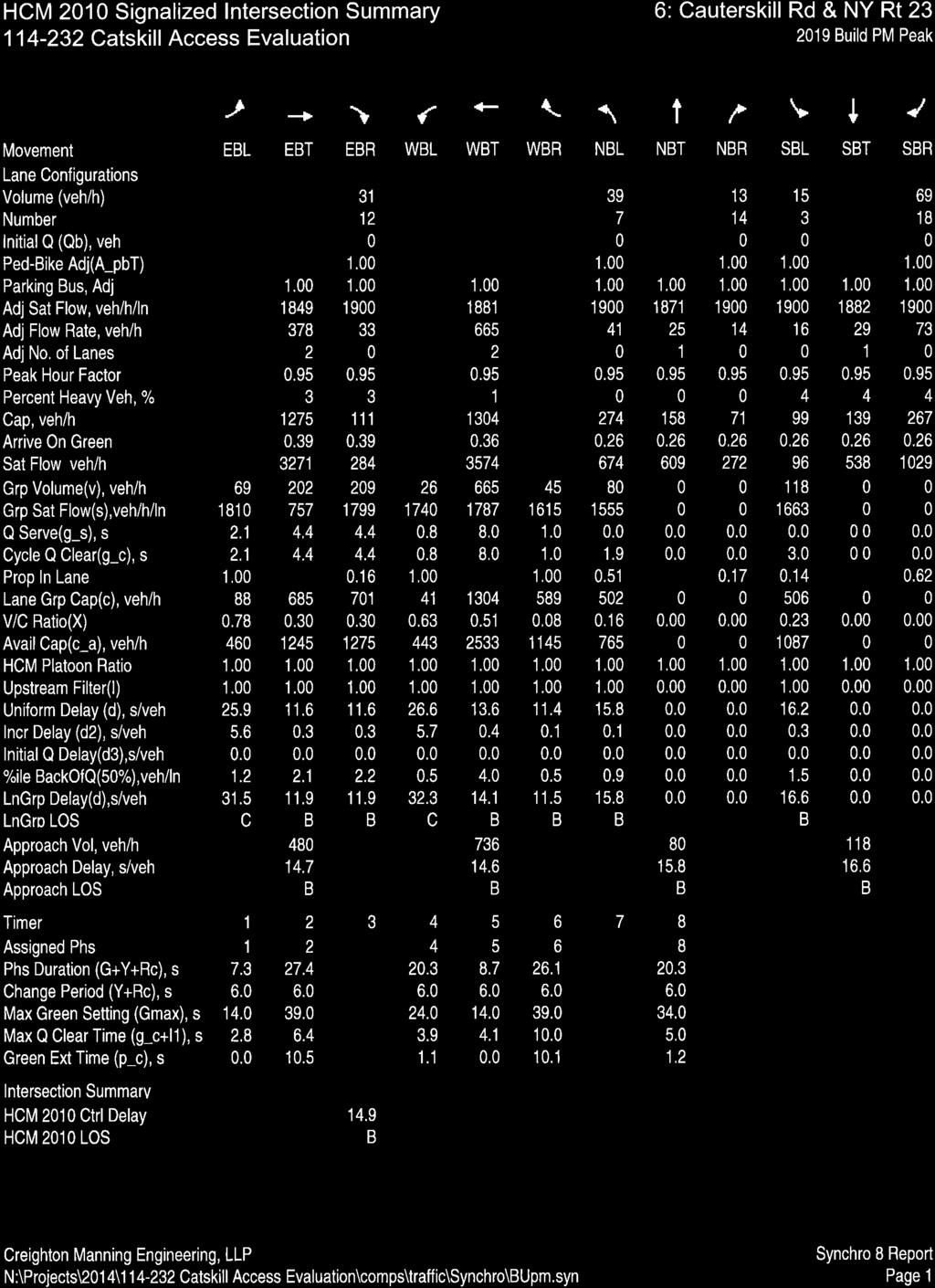
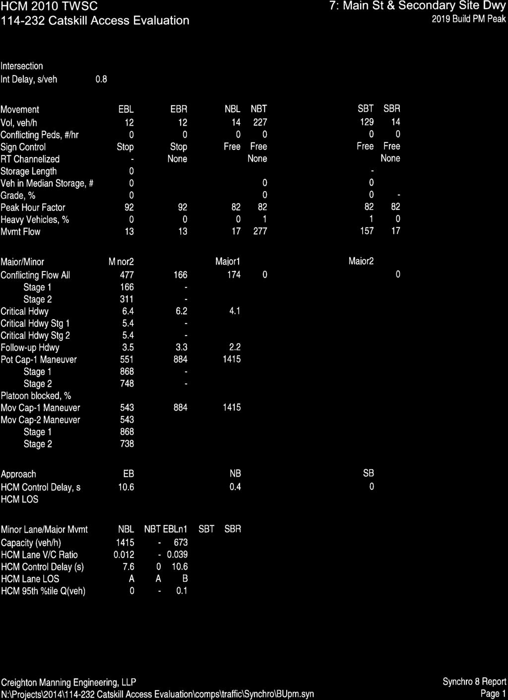
23 Table 4.2 PM Peak Hour Level of Service Summary Intersection Main St/NY Rt 23 EB Ramps NY Rt 23 EB Ramp EB Main St SB Main St/NY Rt 23 WB Ramps NY Rt 23 WB Ramp WB Main St NB Main St/Thruway Exit 21/Oak St Oak St EB Thruway Exit 21 WB County Route 23B NB County Route 23B SB LT R L LT R L LT R LT L T L TR Control TW TW S 2016 Existing D (28.1) A (9.9) A (8.6) C (19.3) B (11.9) A (8.5) B (13.5) B (13.8) C (28.0) B (11.5) B (14.1) B (10.2) B (11.7) 2019 No-Build D (28.7) A (9.9) A (8.7) C (19.5) B (11.9) A (8.5) B (13.5) B (13.8) C (28.5) B (11.5) B (14.1) B (10.2) B (11.7) 2019 Build D (34.3) A (9.9) A (8.8) C (20.2) B (12.5) A (8.6) B (14.6) B (15.0) C (33.4) B (12.5) B (16.1) B (10.3) B (11.5) Overall C (20.6) C (20.8) C (21.0) Access Rd (Primary Site Dwy)/Main St/Forest Hills Ave TW Access Rd (Primary Dwy) EB Forest Hills Ave WB Main St NB Main St SB LTR [LT] [R] LT R [LTR] LTR [L] LTR B (11.2) B (11.5) A (9.6) -- A (7.4) -- A (8.1) B (11.2) B (11.5) A (9.6) -- A (7.4) -- A (8.2) D (34.8) E (46.2) A (9.5) -- A (8.2) -- A (8.1) Main St/Cauterskill Rd TW Cauterskill Rd NB Main St WB LR LT A (9.8) A (7.5) A (9.8) A (7.5) B (10.3) A (7.6) NY Rt 23/Cauterskill Rd S NY Rt 23 EB NY Rt 23 WB Cauterskill Rd NB Cauterskill Rd SB L T,TR L T,T R LTR LTR C (30.2) B (12.0) C (30.8) B (13.0) B (10.6) B (15.1) B (15.3) C (30.2) B (12.0) C (30.8) B (13.0) B (10.6) B (15.1) B (15.3) C (31.5) B (11.9) C (32.3) B (14.1) B (11.5) B (15.8) B (16.6) Overall B (13.6) B (13.6) B (14.9) Main St/Secondary Site Dwy TW Main St NB LT A (7.6) Secondary Dwy EB LR B (10.6) S, TW = Traffic Signal or Two-Way Stop controlled intersection EB, WB, NB, SB = Eastbound, Westbound, Northbound, or Southbound intersection approaches L, T, R = Left-turn, Through, and/or Right-turn intersection movements X (Y.Y) = Level of service (Average Delay in seconds per vehicle) -- = Not Applicable 2019 Build w/ Imp E (41.1) B (10.2) D (31.7) -- A (8.2) A (8.1) The following observations are noted regarded the level of service and capacity evaluations: Catskill Access Evaluation, Town of Catskill, NY Page 19
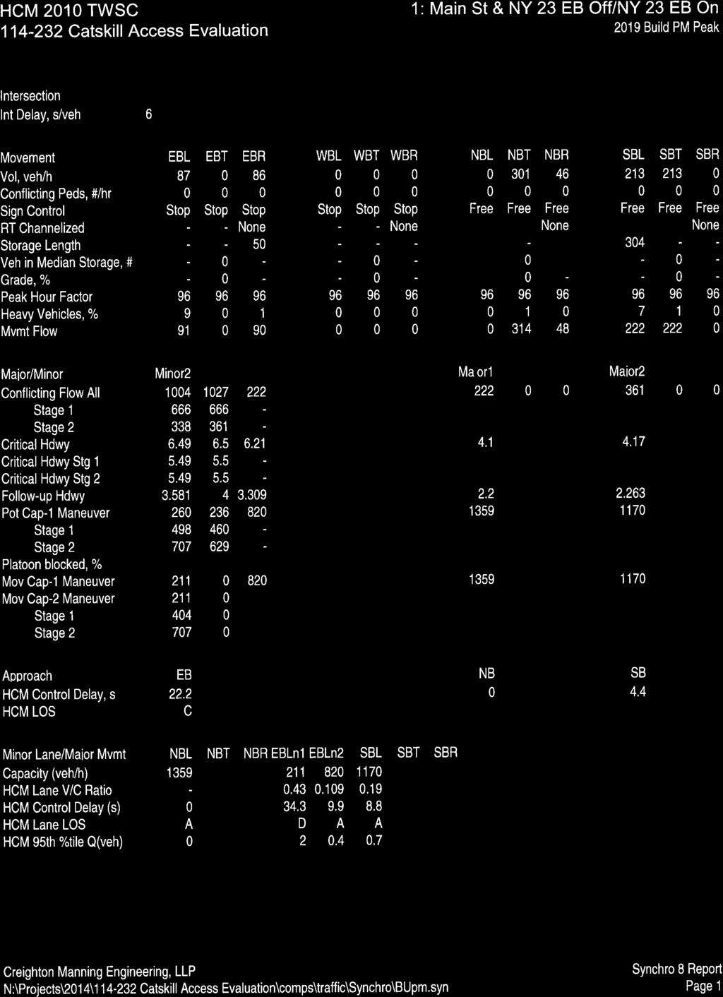
24 Main St/NY Route 23B Eastbound Ramps The eastbound off-ramp approach to Main Street operates at LOS D/A during the PM peak hour and the southbound Main Street left-turn movement operates at LOS A. These levels of service will be maintained through No-Build and Build conditions. Main St/NY Route 23B Westbound Ramps The westbound off-ramp approach to Main Street operates at LOS C/B during the PM peak hour and the northbound Main Street left-turn movement operates at LOS A. These levels of service will be maintained through No-Build and Build conditions. Main Street/Thruway Exit 21/Oak Street The analysis shows that the intersection currently operates at overall LOS C conditions with all movements operating at LOS C or better. These levels of service will be maintained through No-Build and Build conditions. Access Road (Primary Site Driveway)/Main Street/Forest Hills Avenue The Forest Hills Avenue and Access Road approaches to the intersection currently operate at LOS A/B conditions while the northbound and southbound left-turn movements on Main Street operate at LOS A. These levels of service will be maintained through 2019 No-Build conditions. With construction of the project, the Access Road will be modified to become the Primary Site Driveway. The Primary Site Driveway and Forest Hills Avenue approaches will operate at LOS D/E conditions. It is estimated that approximately 90% of the site traffic will enter/exit the site via the Primary Site Driveway. As part of construction of the project it is recommended that improvements to the intersection be constructed to provide a more standard alignment of the Primary Site Driveway approach to Main Street. Review of the AASHTO guidelines for construction of left-turn lanes shows that the future traffic volumes meet the criteria for construction of a northbound left-turn lane on Main Street entering the site. Based on the number of vehicles exiting the site and turning right onto Main Street, it is also recommended that a right-turn lane be constructed on the Primary Site Driveway approach to the intersection. In addition, the Forest Hills Avenue approach to the intersection should be modified to provide a typical single lane approach rather than the existing shared left-turn/through lane and channelized right-turn lane. A preliminary review of available mapping indicates that adequate right-of-way exists to complete the recommended intersection modifications. The right-of-way will need to be confirmed as the project and design progresses. With these changes to the intersection, the Primary Site Driveway approach to the intersection will operate at LOS E/B with approximately 41 seconds of average delay for the shared left-turn/through movement and 10 seconds of average delay for the right-turn movement. The shared Forest Hills Avenue approach will operate at LOS D with approximately 32 seconds of average delay. The proposed intersection modifications are conceptually shown on Figure 4.1. Catskill Access Evaluation, Town of Catskill, NY Page 20
25 Main Street/Cauterskill Road The stop controlled Cauterskill Road approach to the intersection currently operates at LOS A and the Main Street westbound left-turn movement operates at LOS A. These levels of service are maintained through the 2019 No-Build conditions. With construction of the project the Cauterskill Road will operate at LOS B with a 0.5 second increased in average delay and the Main Street left-turn movement will continue to operate at LOS A. Cauterskill Road/NY Route 23 The analysis shows that the intersection currently operates at overall LOS B conditions with all movements operating at LOS C or better. These levels of service will be maintained through No-Build and Build conditions. Main Street/Secondary Site Driveway The Secondary Site Driveway will operate at LOS B with single lanes entering and exiting the site and unsignalized intersection control. It is estimated that approximately 10% of the site traffic will enter and exit via this driveway. C. Multi-Modal The project site is located within a relatively rural area with limited pedestrian, bicycle, and transit accommodations. As the project continues through the review and development process, the Applicant should coordinate with the local transit agency to determine the potential for providing transit service to the site. In addition, pedestrians should be accommodated within the site through construction of sidewalks or multi-use paths. D. Sensitivity Evaluation The detailed traffic capacity evaluation was completed for the worst case trip generation scenario. However, the preferred development scenario is Alternate 1 which includes the construction of an indoor recreation center, and outdoor adventure center, hotel, resort hotel, and a conference center. Trips associated with Alternate 1 were assigned to the study area consistent with Alternate 2 and added to the 2019 No-Build traffic volumes to develop the 2019 Build Alternate 1 traffic volumes. Review of Table 4.2 shows that level of service impacts are only expected at the Primary Site Driveway intersection with Main Street; therefore, the Main Street/Primary Site Driveway intersection was evaluated with construction of the preferred development scenario as summarized in Table 4.3. Review of the AASHTO leftturn lane guidance shows that future traffic volumes with construction of Alternate 1 satisfy the Catskill Access Evaluation, Town of Catskill, NY Page 21
26 guidelines for construction of a left-turn lane on Main Street. Therefore, the Build Alternate 1 level of service evaluations include the mitigation identified in Table 4.2. Intersection Table PM Peak Hour Level of Service Summary Access Rd (Primary Site Dwy)/Main St/Forest Hills Ave Access Rd (Primary Dwy) EB [LT] [R] Forest Hills Ave WB [LTR] Main St NB [L] Main St SB LTR Control TW Build with Improvements Alternate 2 Alternate 1 E (41.1) B (10.2) D (31.7) A (8.2) A (8.1) S, TW = Traffic Signal or Two-Way Stop controlled intersection EB, WB, NB, SB = Eastbound, Westbound, Northbound, or Southbound intersection approaches L, T, R = Left-turn, Through, and/or Right-turn intersection movements X (Y.Y) = Level of service (Average Delay in seconds per vehicle) C (19.2) B (10.4) C (21.0) A (7.8) A (8.2) The level of service evaluation shows that with the intersection modification presented in the worst case evaluation, the Primary Site Driveway/Main Street/Forest Hills Avenue intersection will operate at LOS C or better on all approaches. No additional mitigation is needed with construction of Alternate 1, the preferred development scenario. Catskill Access Evaluation, Town of Catskill, NY Page 22


27 N NYS THRUWAY COUNTY ROUTE 23B N:\Projects\2014\ Catskill Access Evaluation\cadd\dgn\figures\ _fig_concept_pln.dgn FILE NAME = 12/14/2016 DATE/TIME = dborjas USER = FAMILY ENT 25K ' 1" = 60' HOTEL 20K CONCEPT PLAN CATSKILL ACCESS EVALUATION TOWN OF CATSKILL, NEW YORK Y ACCESS DRIVE PROJECT: DATE: 11/2016 FIGURE: 4.1
28 GREENE greene N COUNTY 23b COUNTY Main St Forest Hils Ave Exit OakS t 112 N:\Projects\2014\ Catskil Access Evaluation\cadd\dgn\figures\ _fig_traf_01.dgn NYS Thruway ALTERNATE 1 TRIP ASSIGNMENT CATSKILL ACCESS EVALUATION TOWN OF CATSKILL, NEW YORK Jefferson Heights PROJECT: DATE: 12/2016 FIGURE: 4.2


29 GREENE greene N COUNTY 23b COUNTY Main St Forest Hils Ave Exit OakS t N:\Projects\2014\ Catskil Access Evaluation\cadd\dgn\figures\ _fig_traf_01.dgn NYS Thruway ALTERNATE 1 BUILD TRAFFIC VOLUMES CATSKILL ACCESS EVALUATION TOWN OF CATSKILL, NEW YORK Jefferson Heights PROJECT: DATE: 12/2016 FIGURE:
30 CHAPTER V CONCLUSIONS AND RECOMMENDATIONS A Traffic Impact Study was completed for the development of approximately 60 acres located on the west side of the NYS Thruway bordered by Main Street (CR 23B) to the north and NY Route 23 to the south. Four potential mixed-use development scenario Alternates, to be completed in 2019, have been evaluated: Alternate 1 Alternate 2 Water Park/Resort Hotel w/ cabins 425 Rooms Indoor Recreation 130,000 SF Conference Center 20,000 SF Outdoor Adventure Center 4 Acres Hotel 80 Rooms Hotel 80 Rooms Indoor Activity Center 27,500 SF Restaurant 15,000 SF Outdoor Adventure Center 9 Acres Apartments 96 Units Townhouses 60 Units Convenience Store/Gas Station 4,300 SF Alternate 3 Alternate 4 National Brand Retail 82,500 SF Warehouse/Distribution Center 201,250 SF Retail Plaza 13,000 SF Office 159,600 SF Truck Stop 15,000 SF Hotel 80 Rooms Hotel 80 Rooms Restaurant 15,000 SF Restaurant 15,000 SF Apartments 96 Units Apartments 96 Units Townhouses 60 Units Townhouses 60 Units Convenience Store/Gas Station 4,300 SF Access to the site will be the same for all development scenarios with two full access roadways intersecting Main Street from the south; primary access across from Forest Hills Avenue and a secondary access approximately 550-feet west. The study focuses on the weekday PM peak hour commuter peak period. 1. Alternate 2 is expected to generate the highest number of PM peak hour trips with a total of 510 new trips (281 entering and 229 exiting). Detailed evaluations were completed for this worst case development scenario. 2. The sight distance analysis shows that the available sight distances along the site frontage on Main Street meet the AASHTO guidelines for a 40-mph operating speed at the Primary Site Driveway/Forest Hills Avenue intersection. The sight distance analysis for the Secondary Site Driveway meets the AASHTO guidelines for a 40-mph Catskill Access Evaluation, Town of Catskill, NY Page 26
31 operating speed with the exception of drivers looking left to make a left or righthand turn out of the site driveway. A review of the criteria in the New York State Supplement to the NMUTCD indicates that while the sight distance looking left is less than desirable, it is not critically limited; however, the site driveway should be relocated approximately 100-feet east to provide available sight distances that meet AASHTO guidelines for all movements. 3. The level of service evaluation shows that with the exception of the Access Road (Primary Site Driveway)/Main Street/Forest Hills Avenue intersection, the study area intersections will maintain good levels of service with construction of the proposed project. 4. The Primary Site Driveway approach to Main Street is expected to operate at LOS E with construction of Alternate 2. Review of AASHTO guidelines shows that the future traffic volumes meet the guidelines for construction of a northbound left-turn lane on Main Street. With construction of the northbound left-turn lane, left and right-turn lanes exiting the site, and modifying the Forest Hills Avenue approach to the intersection to provide a more typical four-leg intersection, the intersection will operate with acceptable levels of service with construction of the project. 5. The Applicant should coordinate with the local transit agency to determine the potential for providing transit service to the site. In addition, pedestrians should be accommodated within the site through construction of sidewalks or multi-use paths. 6. The sensitivity analysis completed for construction of the preferred development scenario (Alternate 1) shows that the mitigation measures identified for construction of Alternate 2 are also recommended if the preferred design scenario is progressed. The improvement measures identified through the TIS will mitigation project impacts for any of the four development scenario Alternates. Catskill Access Evaluation, Town of Catskill, NY Page 27
32 Appendix A Site Plans Traffic Impact Study Catskill Access Evaluation Town of Catskill, New York

33 AY W RU TH 7 I-8 NY S RT REVISIONS 20K ALTERNATE 1 S CIVIL AND ENVIRONMENTAL ENGINEERING DELAWARE ENGINEERING, D.P.C. B 23 NY RT H:\Drawings\GCIDA\Cat 21\ACAD-Cat 21 Site Rev6 Alt 1.dwg, ALT 1, 10/3/2016 4:09:08 PM Y CT FAMILY ENT 25K 23 SHEET: ALT 1 FILE: PROJECT NO.: REVIEWED BY: SCALE: DRAWN BY: DATE:


34 ALTERNATE 2 AY W RU TH 7 I-8 REVISIONS CIVIL AND ENVIRONMENTAL ENGINEERING DELAWARE ENGINEERING, D.P.C. B 23 RT S RT S NY Y CT NY 23 SHEET: ALT 2 FILE: PROJECT NO.: REVIEWED BY: SCALE: DRAWN BY: DATE:
35 ALTERNATE 3 AY W RU TH 7 I-8 REVISIONS CIVIL AND ENVIRONMENTAL ENGINEERING DELAWARE ENGINEERING, D.P.C. B 23 RT S RT S NY Y CT NY 23 SHEET: ALT 3 FILE: PROJECT NO.: REVIEWED BY: SCALE: DRAWN BY: DATE:
36 ALTERNATE 4 AY W RU TH 7 I-8 REVISIONS CIVIL AND ENVIRONMENTAL ENGINEERING DELAWARE ENGINEERING, D.P.C. B 23 RT S RT S NY Y CT NY 23 SHEET: ALT 4 FILE: PROJECT NO.: REVIEWED BY: SCALE: DRAWN BY: DATE:
37 Appendix B Turning Movement Counts Traffic Impact Study Catskill Access Evaluation Town of Catskill, New York
38
39
40
41
42
43
44
45
46
47
48
49
50 Appendix C Detailed Trip Generation Estimates Traffic Impact Study Catskill Access Evaluation Town of Catskill, New York
51 Trip Generation - Alternate 1 Land Use Size pass-by PM Peak Hour enter exit total Resort Hotel w/ cabins 425 room multi-use pass-by 0% new Conference Center 20,000 SF multi-use 10% pass-by 0% new Hotel 80 rooms multi-use pass-by 0% new Indoor Activity Center 27,500 SF multi-use 10% pass-by 0% new Outdoor Adventure Center 9 acres multi-use 10% pass-by 0% new Site Trips multi-use pass-by new N:\Projects\2014\ Catskill Access Evaluation\comps\traffic\114232_Trip Gen_ Trip Gen
52 Trip Generation - Alternate 2 Land Use Size pass-by PM Peak Hour enter exit total Indoor Activity Center 130,000 SF multi-use 10% pass-by 0% new Outdoor Adventure Center 4 acres multi-use 10% pass-by 0% new Hotel 80 rooms multi-use pass-by 0% new Restaurant 15,000 SF multi-use pass-by 40% new Apartments 96 units multi-use pass-by 0% new Townhouses 60 units multi-use pass-by 0% new Convenience Store/Gas Station 4,300 SF multi-use pass-by 65% new Site Trips multi-use pass-by new N:\Projects\2014\ Catskill Access Evaluation\comps\traffic\114232_Trip Gen_ Trip Gen
53 Trip Generation - Alternate 3 Land Use Size pass-by PM Peak Hour enter exit total National Brand Retail 82,500 SF multi-use pass-by 35% new Retail Plaza 13,000 SF multi-use pass-by 35% new Truck Stop 15,000 SF fueling stations 20 pumps multi-use pass-by 65% new high-turnover restaurant 5,000 SF multi-use pass-by 40% new multi-use pass-by 0% new Hotel 80 rooms multi-use pass-by 0% new Restaurant 15,000 SF multi-use pass-by 40% new Apartments 96 units multi-use pass-by 0% new Townhouses 60 units multi-use pass-by 0% new Site Trips multi-use pass-by new N:\Projects\2014\ Catskill Access Evaluation\comps\traffic\114232_Trip Gen_ Trip Gen
54 Trip Generation - Alternate 4 Land Use Size pass-by PM Peak Hour enter exit total Warehouse/Distribution 201,250 SF multi-use pass-by 0% new Office 159,600 SF multi-use pass-by 0% new Hotel 80 rooms multi-use pass-by 0% new Restaurant 15,000 SF multi-use pass-by 40% new Apartments 96 units multi-use pass-by 0% new Townhouses 60 units multi-use pass-by 0% new Convenience Store/Gas Station 4,300 SF multi-use pass-by 65% new Site Trips multi-use 34% pass-by 13% new N:\Projects\2014\ Catskill Access Evaluation\comps\traffic\114232_Trip Gen_ Trip Gen
55 Appendix D Level of Service Analysis Traffic Impact Study Catskill Access Evaluation Town of Catskill, New York
56 LOS Definitions The following is an excerpt from the 2000 Highway Capacity Manual (HCM). Level of Service for Signalized Intersections Level of service for a signalized intersection is defined in terms of control delay, which is a measure of driver discomfort, frustration, fuel consumption, and increased travel time. The delay experienced by a motorist is made up of a number of factors that relate to control, geometrics, traffic, and incidents. Total delay is the difference between the travel time actually experienced and the reference travel time that would result during base conditions: in the absence of traffic control, geometric delay, any incidents, and any other vehicles. Specifically, LOS criteria for traffic signals are stated in terms of the average control delay per vehicle, typically for a 15-minute analysis period. Delay is a complex measure and depends on a number of variables, including the quality of progression, the cycle length, the green ratio, and the v/c ratio for the lane group. Levels of service are defined to represent reasonable ranges in control delay. LOS A describes operations with low control delay, up to 10 s/veh. This LOS occurs when progression is extremely favorable and most vehicles arrive during the green phase. Many vehicles do not stop at all. Short cycle lengths may tend to contribute to low delay. LOS B describes operations with control delay greater than 10 and up to 20 s/veh. This level generally occurs with good progression, short cycle lengths, or both. More vehicles stop than with LOS A, causing higher levels of delay. LOS C describes operations with control delay greater than 20 and up to 35 s/veh. These higher delays may result from only fair progression, longer cycle lengths, or both. Individual cycle failures may begin to appear at this level. Cycle failure occurs when a given green phase does not serve queued vehicles, and overflows occur. The number of vehicles stopping is significant at this level, though many still pass through the intersection without stopping. LOS D describes operations with control delay greater than 35 and up to 55 s/veh. At LOS D, the influence of congestion becomes more noticeable. Longer delays may result from some combination of unfavorable progression, long cycle lengths, and high v/c ratios. Many vehicles stop, and the proportion of vehicles not stopping declines. Individual cycle failures are noticeable. LOS E describes operations with control delay greater than 55 and up to 80 s/veh. These high delay values generally indicate poor progression, long cycle lengths, and high v/c ratios. Individual cycle failures are frequent. LOS F describes operations with control delay in excess of 80 s/veh. This level, considered unacceptable to most drivers, often occurs with oversaturation, that is, when arrival flow rates exceed the capacity of lane groups. It may also occur at high v/c ratios with many individual cycle failures. Poor progression and long cycle lengths may also be contribute significantly to high delay levels. Average control delay and queue length at roundabout controlled intersections are calculated using SIDRA Intersection. The physical geometry such as entry lane width and approach flare, and traffic volume at the roundabout are factors that influence the intersection s performance. The average delay reported using SIRA Intersection is based on the HCM Method of Delay for Level-of-Service.
57 Level of Service Criteria for Unsignalized Intersections Four measures are used to describe the performance of two-way stop controlled intersections: control delay, delay to major street through vehicles, queue length, and v/c ratio. The primary measure that is used to provide an estimate of LOS is control delay. This measure can be estimated for any movement on the minor (i.e., stopcontrolled) street. By summing delay estimates for individual movements, a delay estimate for each minor street movement and minor street approach can be achieved. The level of service criteria is given in Exhibit 17-2/22. For all-way stop controlled (AWSC) intersections, the average control delay (in seconds per vehicle) is used as the primary measure of performance. Control delay is the increased time of travel for a vehicle approaching and passing through an AWSC intersection, compared with a free-flow vehicle if it were not required to slow or stop at the intersection. Exhibit 17-2/22: Level-of-Service Criteria for Stop Controlled Intersections Level of Service Control Delay (sec/veh) A < 10.0 B >10.0 and < 15.0 C >15.0 and < 25.0 D >25.0 and < 35.0 E >35.0 and < 50.0 F >50.0
58
59
60
61
62
63
64
65
66
67
68
69
70
71
72
73
74
75
76
77
Traffic Impact Analysis Chatham County Grocery Chatham County, NC
 Chatham County Grocery Chatham County, NC TABLE OF CONTENTS 1. INTRODUCTION... 1 1.1. Location and Study Area... 1 1.2. Proposed Land Use and Access... 2 1.3. Adjacent Land Uses... 2 1.4. Existing ways...
MEETING FACILITY 2901 GIBFORD DRIVE CITY OF OTTAWA TRANSPORTATION BRIEF. Prepared for: Holiday Inn Express 2881 Gibford Drive Ottawa, ON K1V 2L9
 MEETING FACILITY 2901 GIBFORD DRIVE CITY OF OTTAWA TRANSPORTATION BRIEF Prepared for: Holiday Inn Express 2881 Gibford Drive Ottawa, ON K1V 2L9 December 18, 2012 112-566 Brief_1.doc D. J. Halpenny & Associates
Traffic Impact Study WestBranch Residential Development Davidson, NC March 2016
 Traffic Impact Study WestBranch Residential Development Davidson, NC March 216 TRAFFIC IMPACT STUDY FOR THE WestBranch Residential Development LOCATED IN DAVIDSON, NC Prepared For: Lennar Carolinas, LLC
INDUSTRIAL BUILDING 3009 HAWTHORNE ROAD CITY OF OTTAWA TRANSPORTATION OVERVIEW REVISED. Prepared for: Canada Inc.
 INDUSTRIAL BUILDING 3009 HAWTHORNE ROAD CITY OF OTTAWA TRANSPORTATION OVERVIEW REVISED Prepared for: 7849648 Canada Inc. Octiober 1, 2015 114-598 Overview_2.doc D. J. Halpenny & Associates Ltd. Consulting
TRAFFIC IMPACT STUDY And A TRAFFIC SIGNAL WARRANT ANALYSIS FOR A SENIOR LIVING AND APARTMENT DEVELOPMENT
 TRAFFIC IMPACT STUDY And A TRAFFIC SIGNAL WARRANT ANALYSIS FOR A SENIOR LIVING AND APARTMENT DEVELOPMENT DEERFIELD TOWNSHIP, WARREN COUNTY, OHIO Nantucket Circle and Montgomery Road () Prepared for: ODLE
QUICKIE C STORE AND GAS BAR 1780 HERON ROAD OTTAWA, ONTARIO TRANSPORTATION BRIEF. Prepared for:
 QUICKIE C STORE AND GAS BAR 1780 HERON ROAD OTTAWA, ONTARIO TRANSPORTATION BRIEF Prepared for: Quickie Convenience Stores Larny Holdings Ltd. c/o PBC Group April 15, 2015 115-615 Report_1.doc D. J. Halpenny
Traffic Impact Analysis Walton Acres at Riverwood Athletic Club Clayton, NC
 Traffic Impact Analysis Walton Acres at Riverwood Athletic Club Clayton, NC 1. TABLE OF CONTENTS INTRODUCTION...1 1.1. Site Location and Study Area...1 1.2. Proposed Land Use and Site Access...2 1.3.
Figure 1: Vicinity Map of the Study Area
 ARIZONA TEXAS NEW MEXICO OKLAHOMA May 5, 2016 Mr. Anthony Beach, P.E. BSP Engineers 4800 Lakewood Drive, Suite 4 Waco, Texas 76710 Re: Intersection and Access Analysis along Business 190 in Copperas Cove
5858 N COLLEGE, LLC N College Avenue Traffic Impact Study
 5858 N COLLEGE, LLC nue Traffic Impact Study August 22, 2016 Contents Traffic Impact Study Page Preparer Qualifications... 1 Introduction... 2 Existing Roadway Conditions... 5 Existing Traffic Conditions...
OFFICE/RETAIL DEVELOPMENT 1625 BANK STREET OTTAWA, ONTARIO TRANSPORTATION BRIEF. Prepared for: Canada Inc.
 OFFICE/RETAIL DEVELOPMENT 1625 BANK STREET OTTAWA, ONTARIO TRANSPORTATION BRIEF Prepared for: 9402209 Canada Inc. December 15, 2015 115-625 Report_2.doc D. J. Halpenny & Associates Ltd. Consulting Transportation
HILTON GARDEN INN HOTEL HOTEL EXPANSION 2400 ALERT ROAD, OTTAWA TRANSPORTATION BRIEF. Prepared for:
 HILTON GARDEN INN HOTEL HOTEL EXPANSION 2400 ALERT ROAD, OTTAWA TRANSPORTATION BRIEF Prepared for: Bona Building & Management Co. Ltd. Place Vanier, 333 North River Road Vanier, Ontario K1L 8B9 October
INDUSTRIAL BUILDING 1660 COMSTOCK ROAD CITY OF OTTAWA TRANSPORTATION OVERVIEW. Prepared for:
 INDUSTRIAL BUILDING 1660 COMSTOCK ROAD CITY OF OTTAWA TRANSPORTATION OVERVIEW Prepared for: Simluc Contractors Limited 2550 Blackwell Street, Ottawa K1B 5R1 October 18, 2013 113-584 Overview_1.doc D. J.
Traffic Circulation Study for Neighborhood Southwest of Mockingbird Lane and Airline Road, Highland Park, Texas
 ARIZONA TEXAS NEW MEXICO OKLAHOMA February 13, 2015 Mr. Meran Dadgostar P.E., R.S. Town of Highland Park 4700 Drexel Dr. Highland Park, Texas 75205 Re: Traffic Circulation Study for Neighborhood Southwest
MEDICAL/OFFICE BUILDING 1637 BANK STREET OTTAWA, ONTARIO TRANSPORTATION OVERVIEW. Prepared for:
 MEDICAL/OFFICE BUILDING 1637 BANK STREET OTTAWA, ONTARIO TRANSPORTATION OVERVIEW Prepared for: 2434984 Ontario Inc. 13-5510 Canotek Road Ottawa, Ontario K1J 9J5 June 4, 2015 115-613 Report_2.doc D. J.
Project Report. South Kirkwood Road Traffic Study. Meadows Place, TX October 9, 2015
 Meadows Place, TX October 9, 2015 Contents 1 Introduction... 1 2 Data Collection... 1 3 Existing Roadway Network... 2 4 Traffic Volume Development... 2 5 Warrant Analysis... 3 6 Traffic Control Alternative
Traffic Impact Study. Roderick Place Columbia Pike Thompson s Station, TN. Transportation Group, LLC Traffic Engineering and Planning
 F i s c h b a c h Transportation Group, LLC Traffic Engineering and Planning Traffic Impact Study Roderick Place Columbia Pike Thompson s Station, TN Prepared March 2016 Ms. Gillian L. Fischbach, P.E.,
Shockoe Bottom Preliminary Traffic and Parking Analysis
 Shockoe Bottom Preliminary Traffic and Parking Analysis Richmond, Virginia August 14, 2013 Prepared For City of Richmond Department of Public Works Prepared By 1001 Boulders Pkwy Suite 300, Richmond, VA
URBAN QUARRY HEADQUARTERS 2717 STEVENAGE DRIVE CITY OF OTTAWA TRANSPORTATION OVERVIEW. Prepared for: Urban Quarry 4123 Belgreen Drive, Ottawa K1G 3N2
 URBAN QUARRY HEADQUARTERS 2717 STEVENAGE DRIVE CITY OF OTTAWA TRANSPORTATION OVERVIEW Prepared for: Urban Quarry 4123 Belgreen Drive, Ottawa K1G 3N2 February 27, 2014 113-584 Overview_1.doc D. J. Halpenny
Walmart (Store # ) 60 th Street North and Marion Road Sioux Falls, South Dakota
 60 th Street North and Marion Road Sioux Falls, South Dakota") Walmart (Store #4865-00) 60 th Street North and Marion Road Sioux Falls, South Dakota Prepared for: Wal-Mart Stores, Inc. Bentonville, Arkansas Prepared by: Kimley-Horn and Associates, Inc. ã2013 Kimley-Horn
Walmart (Store #4865-00) 60 th Street North and Marion Road Sioux Falls, South Dakota Prepared for: Wal-Mart Stores, Inc. Bentonville, Arkansas Prepared by: Kimley-Horn and Associates, Inc. ã2013 Kimley-Horn
List of Attachments. Location Map... Site Plan... City of Lake Elsinore Circulation Element... City of Lake Elsinore Roadway Cross-Sections...
 List of Attachments Exhibits Location Map... Site Plan... City of Lake Elsinore Circulation Element... City of Lake Elsinore Roadway Cross-Sections... Existing Lane Geometry and Traffic Controls... Existing
Troutbeck Farm Development
 Troutbeck Farm Development Willistown Township, Chester County PA For Submission To: Willistown Township Last Revised: October, 4 TPD# INLM.A. 5 E. High Street Suite 65 Pottstown, PA 9464 6.36.3 TPD@TrafficPD.com
FAIRFIELD INN & SUITES HOTEL 135 THAD JOHNSON PRIVATE OTTAWA TRANSPORTATION BRIEF. Prepared for:
 FAIRFIELD INN & SUITES HOTEL 135 THAD JOHNSON PRIVATE OTTAWA TRANSPORTATION BRIEF Prepared for: Bona Building & Management Co. Ltd. Place Vanier, 333 North River Road Vanier, Ontario K1L 8B9 August 12,
APARTMENT BUILDING DEVELOPMENT 1161 HERON ROAD OTTAWA, ONTARIO TRANSPORTATION IMPACT STUDY. Prepared for:
 APARTMENT BUILDING DEVELOPMENT 1161 HERON ROAD OTTAWA, ONTARIO TRANSPORTATION IMPACT STUDY Prepared for: 1649362 Ontario Inc. c/o Manor Park Management 231 Brittany Drive, Suite D Ottawa ON K1K 0R8 July
TRAFFIC IMPACT STUDY COMPREHENSIVE UPDATE TOWN OF THOMPSON S STATION, TENNESSEE PREPARED FOR: THE TOWN OF THOMPSON S STATION
 TRAFFIC IMPACT STUDY COMPREHENSIVE UPDATE TOWN OF THOMPSON S STATION, TENNESSEE PREPARED FOR: THE TOWN OF THOMPSON S STATION Transportation Consultants, LLC 1101 17 TH AVENUE SOUTH NASHVILLE, TN 37212
TRAFFIC ASSESSMENT River Edge Colorado
 TRAFFIC ASSESSMENT River Edge Colorado Submitted by: Fehr & Peers 621 17th Street, Ste. 231 Denver, CO 8293 (33) 296-43 December, 21 App. M-2 Traffic Assessment River Edge Colorado December 21 TABLE OF
TRANSPORTATION ANALYSIS REPORT US Route 6 Huron, Erie County, Ohio
 TRANSPORTATION ANALYSIS REPORT US Route 6 Huron, Erie County, Ohio December 12, 2012 Prepared for: The City of Huron 417 Main Huron, OH 44839 Providing Practical Experience Technical Excellence and Client
REDEVELOPMENT TRAFFIC IMPACT STUDY
 REDEVELOPMENT TRAFFIC IMPACT STUDY For Wendy s Parker, Colorado January 215 Prepared for: Sterling Design Associates, LLC 29 W. Littleton Boulevard #3 Littleton, Colorado 812 Prepared by: 1233 Airport
Traffic Impact Study Little Egypt Road Development Denver, North Carolina June 2017
 Traffic Impact Study Little Egypt Road Development Denver, North arolina June 2017 N. Little Egypt Road DQ\ QDQFLQJ VDOHV RU RWKHU SHUIRUPDQFH EDVHG FULWHULD Proposed Site Driveways Site Driveway 1 TRAFFI
HOLIDAY INN HOTEL 235 KING EDWARD AVENUE CITY OF OTTAWA TRANSPORTATION BRIEF. Prepared for:
 HOLIDAY INN HOTEL 235 KING EDWARD AVENUE CITY OF OTTAWA TRANSPORTATION BRIEF Prepared for: Momentum Planning & Communications 1165 Greenlawn Crescent Ottawa, ON K1L 6C2 June 29, 2015 115-618 Brief_1.doc
Draft Report. Traffic Impact Study. Superstore, Wal-Mart, and Kent Development. Yarmouth, Nova Scotia. Prepared for
 oad & Traffic Management Road & Traffic Management R Atlantic Traffic Engineering Specialists Draft Report Traffic Impact Study Superstore, Wal-Mart, and Kent Development Yarmouth, Nova Scotia Prepared
METHODOLOGY. Signalized Intersection Average Control Delay (sec/veh)
") Chapter 5 Traffic Analysis 5.1 SUMMARY US /West 6 th Street assumes a unique role in the Lawrence Douglas County transportation system. This principal arterial street currently conveys commuter traffic
Chapter 5 Traffic Analysis 5.1 SUMMARY US /West 6 th Street assumes a unique role in the Lawrence Douglas County transportation system. This principal arterial street currently conveys commuter traffic
Subject: Solberg Avenue / I-229 Grade Separation: Traffic Analysis
 MEMORANDUM Transportation Bill Troe, AICP Jason Carbee, AICP 12120 Shamrock Plaza Suite 300 Omaha, NE 68154 (402) 334-8181 (402) 334-1984 (Fax) To: Project File Date: Subject: Solberg Avenue / I-229 Grade
FINAL Albertville Business Park AUAR Update Traffic Study
 FINAL Albertville Business Park AUAR Update Traffic Study Prepared for City of Albertville, MN July 20, 2017 SRF No. 10060.00 Table of Contents Introduction... 1 Existing Conditions... 1 Data Collection...
OTTAWA TRAIN YARDS PHASE 3 DEVELOPMENT CITY OF OTTAWA TRANSPORTATION IMPACT STUDY. Prepared for:
 OTTAWA TRAIN YARDS PHASE 3 DEVELOPMENT CITY OF OTTAWA TRANSPORTATION IMPACT STUDY Prepared for: The Ottawa Train Yards Inc. 223 Colonnade Road South, Suite 212 Nepean, Ontario K2E 7K3 January 17, 2012
6060 North Central Expressway Mixed-Use Site Dallas, Texas
 Volume 1 Traffic Impact Analysis 6060 North Central Expressway Mixed-Use Site Dallas, Texas April 30, 2018 Kimley-Horn and Associates, Inc. Dallas, Texas Project #063238300 Registered Firm F-928 Traffic
NEW YORK CENTRAL PARK SUBDIVISION BLAIS STREET/ST-PIERRE STREET EMBRUN, ONTARIO TRAFFIC IMPACT STUDY. Prepared for:
 NEW YORK CENTRAL PARK SUBDIVISION BLAIS STREET/ST-PIERRE STREET EMBRUN, ONTARIO TRAFFIC IMPACT STUDY Prepared for: Solidex Holdings Limited & Investissement Maurice Lemieux Investments Attn: Mr. Anthony
FRONT RANGE CROSSINGS TRAFFIC IMPACT STUDY
 FRONT RANGE CROSSINGS TRAFFIC IMPACT STUDY Prepared for: City of Thornton And Colorado Department of Transportation Prepared by: 11 Blake Street, Suite 2 Denver, Colorado 822 Contact: Brian Bern, PE, PTOE
TRAFFIC IMPACT ANALYSIS
 TRAFFIC IMPACT ANALYSIS FOR THE CHAMPAIGN UNIT#4 SCHOOL DISTRICT PROPOSED HIGH SCHOOL (SPALDING PARK SITE) IN THE CITY OF CHAMPAIGN Final Report Champaign Urbana Urbanized Area Transportation Study 6/24/2014
Henderson Avenue Mixed-Use Development
 Zoning Case: Z145-3 Traffic Impact Analysis Henderson Avenue Mixed-Use Development Dallas, TX October 26 th, 216 Kimley-Horn and Associates, Inc. Dallas, Texas Project #644827 Registered Firm F-928 Traffic
THIS PAGE LEFT BLANK INTENTIONALLY
 GA SR 25 Spur at Canal Road Transportation Impact Analysis PREPARED FOR GLYNN COUNTY, GEORGIA 1725 Reynolds Street, Suite 300 Brunswick, Georgia 31520 PREPARED BY 217 Arrowhead Boulevard Suite 26 Jonesboro,
Gateway Transportation Study
 Gateway Transportation Study Amherst, Massachusetts SUBMITTED TO University of Massachusetts Amherst Town of Amherst SUBMITTED BY Vanasse Hangen Brustlin, Inc. Watertown, Massachusetts March 213 Back of
Transportation Impact Study for Abington Terrace
 Transportation Impact Study for Abington Terrace Abington Township, Montgomery County, PA Sandy A. Koza, P.E., PTOE PA PE License Number PE059911 Prepared by McMahon Associates, Inc. 425 Commerce Drive,
TRAFFIC STUDY GUIDELINES Clarksville Street Department
 TRAFFIC STUDY GUIDELINES Clarksville Street Department 9/1/2009 Introduction Traffic studies are used to help the city determine potential impacts to the operation of the surrounding roadway network. Two
Traffic Study North Shore School District 112
 Traffic Study North Shore School District 112 Proposed Expansion of Northwood Junior High School Prepared By: May 1, 2015 1. Introduction Kenig, Lindgren, O Hara, Aboona, Inc. (KLOA, Inc.) has been retained
Date: September 7, Project #: Re: Spaulding Youth Center Northfield, NH Property. Traffic Impact Study
 To: Ms. Susan C. Ryan Spaulding Youth Center 72 Spaulding Road Northfield, NH 03276 Date: September 7, 2017 Project #: 52455.00 From: Robin Bousa Director of Transportation Systems Re: Spaulding Youth
EXECUTIVE SUMMARY. Page 1 of 6
 EXECUTIVE SUMMARY The purpose of this report is to identify conformance with the original traffic impact study for the proposed retail development on Lot 5 of Riverdale Retail Filing No. 1 located on the
Harrah s Station Square Casino
 Transportation Analysis Harrah s Station Square Casino Pittsburgh, Pennsylvania Submitted To: City of Pittsburgh and Pennsylvania Gaming Control Board Prepared By: DKS Associates GAI Consultants December
Traffic Impact Study. Westlake Elementary School Westlake, Ohio. TMS Engineers, Inc. June 5, 2017
 TMS Engineers, Inc. Traffic Impact Study Westlake Elementary School Westlake, Ohio June 5, 2017 Prepared for: Westlake City Schools - Board of Education 27200 Hilliard Boulevard Westlake, OH 44145 TRAFFIC
Road Conversion Study Plumas Street
 Plumas Street Phase I Submitted to The Regional Transportation Commission of Washoe County Submitted by Zong Tian, Ph.D., P.E. Saeedeh Farivar Haiyuan Li, Ph.D. Center for Advanced Transportation Education
Table of Contents FIGURES TABLES APPENDICES. Traffic Impact Study Hudson Street Parking Garage MC Project No.: A Table of Contents
 Traffic Impact Study Hudson Street Parking Garage MC Project No.: 151714A Table of Contents Table of Contents I. INTRODUCTION... 2 II. EXISTING CONDITIONS... 5 III. 215 EXISTING TRAFFIC CONDITIONS... 6
Technical Memorandum TRAFFIC IMPACT STUDY. RIDLEY ROAD CONVENIENCE STORE Southampton County, VA. Prepared for: Mr. David Williams.
 Technical Memorandum TRFFIC IMPCT STUDY RIDLEY ROD CONVENIENCE STORE Southampton County, V Prepared for: Mr. David Williams By: Charles Smith, P.E., PTOE EPR Charlottesville, V July 2014 1 TBLE OF CONTENTS
Chapter 16: Traffic and Parking A. INTRODUCTION
 Chapter 6: Traffic and Parking A. ITRODUCTIO This chapter examines the potential traffic and parking impacts of the proposed Fresh Kills Park roads. The analysis of transit and pedestrians is presented
FINAL DESIGN TRAFFIC TECHNICAL MEMORANDUM
 FINAL DESIGN TRAFFIC TECHNICAL MEMORANDUM July 2014 FINAL (SR 43) Project Development and Environment Study From State Road 60 (Adamo Drive) to I-4 (SR 400) Hillsborough County, Florida Work Program Item
DIMARCO CANANDAIGUA PROPERTIES HOUSING PROJECT CANANDAIGUA, ONTARIO COUNTY, NEW YORK
 TRAFFIC IMPACT STUDY FOR THE DIMARCO CANANDAIGUA PROPERTIES HOUSING PROJECT CANANDAIGUA, ONTARIO COUNTY, NEW YORK MARCH 14, 2017 PREPARED FOR: 1950 Brighton Henrietta Town Line Rd Rochester, NY 14623 PREPARED
2. Existing Conditions
 2. Existing Conditions The existing traffic and parking conditions on the site and the surrounding area were reviewed based on the study methodology in Section 1.2. 2.1 Existing Land Use The portion of
APPENDIX 11 TRAFFIC IMPACT STUDY
 APPENDIX 11 TRAFFIC IMPACT STUDY Traffic Impact Study Belleayre Resort at Catskill Park Towns of Shandaken and Middletown, New York CME Project No. 99-057 Prepared For: Crossroads Ventures, LLC 72 Andrew
The Cape Cod Five Cents Savings Bank
 TRAFFIC IMPACT AND ACCESS STUDY The Cape Cod Five Cents Savings Bank Hyannis, Massachusetts PREPARED FOR The Cape Cod Five Cents Savings Bank 19 West Road Orleans, Massachusetts 0263 PREPARED BY 1 Walnut
PINESTONE TRAFFIC IMPACT STUDY Travelers Rest, South Carolina
 PINESTONE TRAFFIC IMPACT STUDY Travelers Rest, South Carolina Prepared for Longbranch Development Prepared by January 13, 219 ii Table of Contents Subject Page Signature Page... i Table of Contents...
DUNBOW ROAD FUNCTIONAL PLANNING
 DUNBOW ROAD FUNCTIONAL PLANNING Final Report August 3, 216 #31, 316 5th Avenue NE Calgary, AB T2A 6K4 Phone: 43.273.91 Fax: 43.273.344 wattconsultinggroup.com Dunbow Road Functional Planning Final Report
Route 28 (South Orleans Road)/Route 39 (Harwich Road)/Quanset Road Intersection
/Route 39 (Harwich Road)/Quanset Road Intersection") TRAFFIC FEASIBILITY STUDY Route 28 (South Orleans Road)/Route 39 (Harwich Road)/Quanset Road Intersection Orleans, Massachusetts Prepared for: Town of Orleans Prepared by: Fay, Spofford & Thorndike, LLC
TRAFFIC FEASIBILITY STUDY Route 28 (South Orleans Road)/Route 39 (Harwich Road)/Quanset Road Intersection Orleans, Massachusetts Prepared for: Town of Orleans Prepared by: Fay, Spofford & Thorndike, LLC
Traffic Impact and Access Study PROPOSED DURKEE FARM ESTATES. Foster Street Littleton, Massachusetts. Prepared for: Grimes Road, LLC.
 Traffic Impact and Access Study PROPOSED DURKEE FARM ESTATES Foster Street Littleton, Massachusetts Prepared for: Grimes Road, LLC. Westford, MA Prepared by: MDM Transportation Consultants, Inc. 28 Lord
Volume 1 Traffic Impact Analysis. Texas Odyssey TIA Dallas, Texas. Kimley-Horn and Associates, Inc. Dallas, Texas. May 23, 2018
 Volume 1 Traffic Impact Analysis Texas Odyssey TIA Dallas, Texas May 23, 2018 Kimley-Horn and Associates, Inc. Dallas, Texas Project #064529800 Registered Firm F-928 Traffic Impact Analysis Texas Odyssey
Traffic Impact Study for Rolling Ridge Redevelopment
 Traffic Impact Study for Rolling Ridge Redevelopment Webster Groves, Missouri October 19, 2018 Prepared For: Gershman Commercial Real Estate 150 North Meramec Avenue Suite 500 St. Louis, Missouri 63105
STILLWATER AVENUE CORRIDOR STUDY Old Town, Maine
 Draft Study STILLWATER AVENUE CORRIDOR STUDY Old Town, Maine SUBMITTED TO: BANGOR AREA COMPREHENSIVE TRANSPORTATION SYSTEM SUBMITTED BY: I MAY 23, 2017 DRAFT STILLWATER AVENUE STUDY FINAL REPORT Table
Glenn Avenue Corridor Traffic Operational Evaluation
 Glenn Avenue Corridor Traffic Operational Evaluation PREPARED FOR: THE CITY OF AUBURN PREPARED BY: DECEMBER 2007 Glenn Avenue Corridor Study--Auburn, Alabama TABLE OF CONTENTS Introduction... 1 Background
TABLE TRAFFIC ANALYSIS SCENARIOS
 4.11 TRANSPORTATION The potential traffic impacts of the proposed project are evaluated in the Buena Park Beach/Orangethorpe Mixed Use Project Traffic Analysis (Traffic Analysis) by Austin-Foust Associates
Traffic Signal Optimization Project (Hosman Road) (Future Coordinated Corridor)
 (Future Coordinated Corridor)") Onondaga County Department of Transportation Traffic Signal Optimization Project (Hosman Road) (Future Coordinated Corridor) Prepared for: Syracuse Metropolitan Transportation Council 126 North Salina
Onondaga County Department of Transportation Traffic Signal Optimization Project (Hosman Road) (Future Coordinated Corridor) Prepared for: Syracuse Metropolitan Transportation Council 126 North Salina
Waterford Lakes Small Area Study
 Waterford Lakes Small Area Study Existing Traffic Conditions PREPARED FOR: ORANGE COUNTY PUBLIC WORKS DEPARTMENT TRAFFIC ENGINEERING DIVISION ORLANDO, FLORIDA PREPARED WITH: INWOOD CONSULTING ENGINEERS
Donahue Drive Corridor Traffic Operational Evaluation
 Donahue Drive Corridor Traffic Operational Evaluation PREPARED FOR: THE CITY OF AUBURN PREPARED BY: JANUARY 2007 Donahue Drive Corridor Study--Auburn, Alabama TABLE OF CONTENTS Introduction... 1 Background
Magnolia Place. Traffic Impact Analysis. Prepared for: City of San Mateo. Prepared by: Hexagon Transportation Consultants, Inc.
 Magnolia Place Traffic Impact Analysis Prepared for: City of San Mateo Prepared by: Hexagon Transportation Consultants, Inc. Updated January 4, 2010 Table of Contents 1. Introduction...1 2. Existing Conditions...6
Roundabout Feasibility Memorandum
 Roundabout Feasibility Memorandum To From Gwen Pipkin Bill Howell Date June 18, 2013 Subject Roundabout Feasibility Study SR 29 PD&E Study From Oil Well Road to SR 82 Collier County, FL FPID 417540-1-22-01
Truck Climbing Lane Traffic Justification Report
 ROUTE 7 (HARRY BYRD HIGHWAY) WESTBOUND FROM WEST MARKET STREET TO ROUTE 9 (CHARLES TOWN PIKE) Truck Climbing Lane Traffic Justification Report Project No. 6007-053-133, P 101 Ι UPC No. 58599 Prepared by:
2016 Church Street Access Study. 100 Clinton Square 126 North Salina Street, Suite 100 Syracuse, NY
 2016 Church Street Access Study 100 Clinton Square 126 North Salina Street, Suite 100 Syracuse, NY 13202 www.smtcmpo.org Syracuse Metropolitan Transportation Council Final Report February 23, 2016 This
COMMERCIAL DEVELOPMENT 2015 ROBERTSON ROAD OTTAWA, ONTARIO TRANSPORTATION BRIEF. Prepared for:
 COMMERCIAL DEVELOPMENT 2015 ROBERTSON ROAD OTTAWA, ONTARIO TRANSPORTATION BRIEF Prepared for: First Bay Properties Inc. 311 Richmond Road, Suite 203 Ottawa, ON K1Z 6X3 August 8, 2017 117-663 Brief_1.doc
Cheyenne Metropolitan Planning Organization
 Dell Range Boulevard Corridor Study PHASE II SECTION 20 DRAFT Prepared for: Cheyenne Metropolitan Planning Organization November 20, 2015 (Section 20 is bordered by Powderhouse Road on the west, Storey
Abrams Associates. Transportation Impact Analysis. City of Rocklin. Prepared for: David Mohlenbrok City of Rocklin 4081 Alvis Court Rocklin, CA 95677
 Transportation Impact Analysis Sierra College Boulevard Commercial Project City of Rocklin Prepared for: David Mohlenbrok City of Rocklin 081 Alvis Court Rocklin, CA 95677 Prepared by: 1875 Olympic Boulevard,
Chapter 4 Traffic Analysis
 Chapter 4 Traffic Analysis PURPOSE The traffic analysis component of the K-68 Corridor Management Plan incorporates information on the existing transportation network, such as traffic volumes and intersection
Grant Avenue Streetscape
 REPORT TYPE GOES HERE Grant Avenue Streetscape PREPARED FOR City of Manassas 9027 Center Street Manassas, VA 20110 PREPARED BY 8300 Boone Boulevard Suite 700 Vienna, Virginia 22182 571.389.8121 July 31,
TRANSPORTATION IMPACT STUDY PROPOSED RIVERFRONT 47 MIXED USE DEVELOPMENT
 November 2016 TRANSPORTATION IMPACT STUDY PROPOSED RIVERFRONT 47 MIXED USE DEVELOPMENT & Aspinwall Borough, Sharpsburg Borough & O Hara Township, Allegheny County, Pennsylvania Prepared for: Riverfront
3.9 - Transportation and Traffic
 Transportation and Traffic 3.9 - Transportation and Traffic This section describes the potential transportation and traffic effects of project implementation on the project site and its surrounding area.
Appendix B. Environmental Resource Technical Memorandum. Assessment on Travel Pattern and Access Impacts
 Appendix B Environmental Resource Technical Memorandum Assessment on Travel Pattern and Access Impacts TECHNICAL MEMORANDUM ENVIRONMENTAL RE-EVALUATION FOR UNION STATION TO OAK CLIFF DALLAS STREETCAR To:
Highway 111 Corridor Study
 Highway 111 Corridor Study June, 2009 LINCOLN CO. HWY 111 CORRIDOR STUDY Draft Study Tea, South Dakota Prepared for City of Tea Sioux Falls Metropolitan Planning Organization Prepared by HDR Engineering,
Evaluation of M-99 (Broad Street) Road Diet and Intersection Operational Investigation
 Road Diet and Intersection Operational Investigation") Evaluation of M-99 (Broad Street) Road Diet and Intersection Operational Investigation City of Hillsdale, Hillsdale County, Michigan June 16, 2016 Final Report Prepared for City of Hillsdale 97 North Broad
Evaluation of M-99 (Broad Street) Road Diet and Intersection Operational Investigation City of Hillsdale, Hillsdale County, Michigan June 16, 2016 Final Report Prepared for City of Hillsdale 97 North Broad
Capital Region Council of Governments
 March 23, 2018 Capital Region Council of Governments PROJECT CONCEPT REPORT Realignment of Swamp and Northfield Road s approaches to Route 44 (Boston Turnpike) Town of Coventry SUMMARY: The Town of Coventry
ALLEY 24 TRAFFIC STUDY
 ALLEY 24 TRAFFIC STUDY in City of Frostburg, Maryland January 2013 3566 Teays Valley Road Hurricane, WV Office: (304) 397-5508 www.denniscorporation.com Alley 24 Traffic Study January 2013 Frostburg, Maryland
APPENDIX E: Transportation Technical Report
 New Jersey Pennsylvania Lackawanna Cut-Off Passenger Rail Service Reston Project Environmental Assessment APPENDIX E: Transportation Technical Report E.1 Introduction As part of the overall environmental
1609 E. FRANKLIN STREET HOTEL TRAFFIC IMPACT STUDY EXECUTIVE SUMMARY
 1609 E. FRANKLIN STREET HOTEL TRAFFIC IMPACT STUDY EXECUTIVE SUMMARY Prepared for: The Town of Chapel Hill Public Works Department Traffic Engineering Division Prepared by: HNTB North Carolina, PC 343
Traffic Impact Statement
 Traffic Impact Statement Mixed Use Development, US 41 and Old Trail Drive aka Tide-Starbucks 4900 9 th Street North General Development Site Plan (GDSP) Collier County, FL 10/6/2015 Prepared for: Prepared
Traffic Analysis and Design Report. NW Bethany Boulevard. NW Bronson Road to NW West Union Road. Washington County, Oregon
 Traffic Analysis and Design Report NW Bethany Boulevard NW Bronson Road to NW West Union Road Washington County, Oregon May 2011 Table of Contents Table of Contents Section 1 Executive Summary... 2 Section
TABLE OF CONTENTS TABLE OF CONTENTS... I APPENDICES... III LIST OF EXHIBITS... V LIST OF TABLES... VII LIST OF ABBREVIATED TERMS...
 TABLE OF CONTENTS TABLE OF CONTENTS... I APPENDICES... III LIST OF EXHIBITS... V LIST OF TABLES... VII LIST OF ABBREVIATED TERMS... IX 1 INTRODUCTION... 1 1.1 Project Overview... 1 1.2 Analysis Scenarios...
Bistro 6. City of Barrie. Traffic Impact Study for Pratt Hansen Group Inc. Type of Document: Final Report. Project Number: JDE 1748
 City of Barrie Traffic Impact Study for Pratt Hansen Group Inc. Type of Document: Final Report Project Number: JDE 1748 Date Submitted: June 12 th, 2017 06/12/17 John Northcote, P.Eng. Professional License
Traffic Study of Fuller Street, Cady Street, West Street and West Avenue. Final Report
 Traffic Study of Fuller Street, Cady Street, West Street and West Avenue Final Report July 2005 Prepared for: Town of Ludlow Prepared by: Pioneer Valley Planning Commission 26 Central Street West Springfield,
MEMORANDUM. Charlotte Fleetwood, Transportation Planner
 MEMORANDUM Date: Updated August 22, 2017 To: Organization: Charlotte Fleetwood, Transportation Planner Boston Transportation Department From: Jason DeGray, P.E., PTOE, Regional Director of Engineering
Appendix B: Forecasting and Traffic Operations Analysis Framework Document
 Existing Conditions Report - Appendix Appendix B: Forecasting and Traffic Operations Analysis Framework Document This document defines the methodology and assumptions that will be used in the traffic forecasting
MEMORANDUM. Our project study area included the following locations:
 MEMORANDUM Date: To: From: Subject: Najib O. Habesch Nick M. Fomenko, PE, PTOE Bushnell Park North Traffic Assessment BETA Project #: 4461 As part of our contract to undertake the design of the Bushnell
ORLEANS GARDENS SHOPPING CENTRE 1615 ORLEANS BOULEVARD CITY OF OTTAWA, ONTARIO TRANSPORTATION IMPACT STUDY. Prepared for:
 ORLEANS GARDENS SHOPPING CENTRE 1615 ORLEANS BOULEVARD CITY OF OTTAWA, ONTARIO TRANSPORTATION IMPACT STUDY Prepared for: Orleans Gardens Shopping Centre Inc. 2851 John Street, Suite 1 Markham, ON K3R 5R7
BLUE SEA VILLAGE MER BLEUE 2159 MER BLEUE ROAD OTTAWA, ONTARIO TRANSPORTATION IMPACT ASSESSMENT. Prepared for: Ontario Limited.
 BLUE SEA VILLAGE MER BLEUE 2159 MER BLEUE ROAD OTTAWA, ONTARIO TRANSPORTATION IMPACT ASSESSMENT Prepared for: 2534189 Ontario Limited April 6, 2018 117-668 TIA Report_2.doc D. J. Halpenny & Associates
Figure 1: East West Connector Alignment Alternatives Concept Drawing
 Page 2 of 9 Figure 1: East West Connector Alignment Alternatives Concept Drawing The Montebello Drive extension will run north south and connect Wilsonville Road to the Boones Ferry Road to Brown Road
DRAFT Davidson Elementary School Expansion Transportation Impact Analysis
 DRAFT Davidson Elementary School Expansion Transportation Impact Analysis Prepared for: Town of Davidson 216 S. Main Street Davidson, NC 28036 Prepared by: Stantec Consulting Services Inc. 2127 Ayrsley
Lyons Avenue/Dockweiler Road Extension Project Draft Environmental Impact Report. Appendix I Traffic Impact Study
 Lyons Avenue/Dockweiler Road Extension Project Draft Environmental Impact Report Appendix I Traffic Impact Study Street 0 80-1947 500.4501 RITA ld Court 0 91355-1096 400.7401 LA n Avenue 0 590-3745 300-9301