APPENDIX 11 TRAFFIC IMPACT STUDY
|
|
|
- Martina Goodman
- 5 years ago
- Views:
Transcription
1 APPENDIX 11 TRAFFIC IMPACT STUDY
2 Traffic Impact Study Belleayre Resort at Catskill Park Towns of Shandaken and Middletown, New York CME Project No Prepared For: Crossroads Ventures, LLC 72 Andrew Lane Road P.O. Box 267 Mt. Tremper, New York Prepared By: February 14, Winners Circle Albany, New York (518)
3 Table of Contents Page Title Page... i Table of Contents...ii List of Figures...iii List of Tables...iii List of Appendices...iii I. INTRODUCTION... 1 A. Planned Project... 2 B. Study Area and Methodology... 3 II. EXISTING CONDITIONS... 6 A. Roadways Serving the Site... 6 B. Study Area Intersections... 7 C. Existing Conditions... 8 III. TRAFFIC FORECASTS A No-Build Traffic Volumes B. Trip Generation C. Trip Distribution D. Trip Assignment E Build Traffic Volumes IV. ANALYSIS A. Accident Analysis B. Capacity/Level of Service Analysis Qualitative Intersection Evaluation C. Sight Distance Analysis V. CONCLUSIONS AND RECOMMENDATIONS ii
4 List of Figures Page Figure 1.1 Project Location... 5 Figure 2.1 Existing Traffic Volumes Figure No-Build Traffic Volumes Figure 3.2 Trip Distribution Highmount Spa Resort Figure 3.3 Trip Distribution Wildacres Resort Figure 3.4 Trip Distribution Shuttle Buses Figure 3.5 Trip Assignment Highmount Spa Resort Figure 3.6 Trip Assignment Wildacres Resort Figure 3.7 Trip Assignment Shuttle Buses Figure Build Traffic Volumes Figure 4.1 Intersection Sight Distance Measurements Figure 4.2 Wildacres Main Access Driveway Concept Plan List of Tables Table 3.1 Summary of Peak Hour Traffic Projections Table 3.2 Trip Generation Summary Table 4.1 Accident Summary Table 4.2 Intersection Level of Service Summary Table 4.3 Sight Distance Evaluation (Feet) List of Appendices Appendix A... Project Master Plan Appendix B...Raw Turning Movement and ATR Data Appendix C... Belleayre Mountain Ski Center Traffic Volumes Appendix D...Level of Service Analysis iii
5 CHAPTER I INTRODUCTION This report summarizes the results of a Traffic Impact Study (TIS) conducted for a proposed resort facility, called Belleayre Resort at Catskill Park, located adjacent to Belleayre Mountain in the Towns of Shandaken and Middletown, Ulster County and Delaware County, New York. This report supersedes the original TIS prepared by Creighton Manning Engineering, LLP (Creighton Manning) dated January 21, The project location is shown on Figure 1.1. The project site is divided into two separate locations; the first, referred to as the Highmount Spa Resort, is located on both sides of County Road 49A (CR 49A) northeast of the Hamlet of Mapledale, southwest of the existing Belleayre Mountain Ski Center. The second, referred to as the Wildacres Resort, is located on the north side of CR 49A directly across from the existing Belleayre Mountain Ski Center. A Project Masterplan is included in Appendix A. The current proposal differs from the previous proposal in several ways. The initial proposal included the development of the Big Indian Plateau resort which was located off of NY Route 28 in the vicinity of Friendship Road. Highmount Estates included the development of 21 single family homes in the initial proposal. With the new proposal, Big Indian Plateau has been removed and a second development, Highmount Spa Resort, has replaced the single family homes at Highmount Estates. Overall, the resorts have reduced in size with 50 fewer fractional units, 72 fewer hotel units, the removal of the 21single family homes, and the removal of an 18-hole golf course. It is noted that the Belleayre Mountain Ski Center is proposing an expansion to their facility as outlined in an updated Unit Management Plan (UMP). The updated UMP outlines the expansion plans for the ski center to include new ski lifts, ski trails and ski-in-ski-out public access to the proposed Belleayre Resort at Catskill Park. As the two projects are closely related, a combined scoping document was prepared for the purpose of the environmental review. Therefore, the traffic study completed for the Belleayre Resort at Catskill Park considers the expansion of the ski center and the interaction of the two sites related to traffic. Belleayre Resort at Catskill Park Page 1
6 A. Planned Project The Highmount Spa Resort will consist of a 120-room hotel with a 24,000 square-foot (SF) spa/fitness center. In addition, 120 fractional lodging units will be constructed of which 53-units will be located within the hotel/spa building, 27-units in a single lodge building, and the remaining 40-units located in detached duplexes or individual units. The existing Leach Farm Building (approximately 12,000 SF) will be renovated for a Conference/Wellness Center on the north side of CR 49A. Access to the main portion of the Highmount Spa Resort will be provided via one access road on the south side of CR 49A. In addition, a loop road located next to the Leach Farm Conference/Wellness Center building will be provided on the north side of CR 49A. The Wildacres Resort will be developed with an 18-hole golf course with a driving range, clubhouse, pro shop, and snack bar. The Wildacres Resort will also include a 208-room hotel with 42 attached fractional units located across from the Belleayre Mountain Ski Center and will include resort retail shops, two restaurants, a lounge, a pool and spa, tennis courts, a 500-seat conference center, a 200-seat ballroom, and meeting rooms. In addition, 55 fractional units will be constructed behind the hotel in multi-unit buildings. An additional building, Marlowe Mansion, will be renovated as a social hall and will also accommodate offices. The Front 9 Village portion of the Wildacres Resort, located northeast of Gunnison Road, will provide 84 fractional units constructed in multi-unit buildings with a community clubhouse. Access to the Wildacres Resort will be provided via four site driveways off of or connecting to CR 49A; the first access will be located on the existing Gunnison Road, the second access servicing hotel traffic will be located across from the Belleayre Mountain Ski Center Upper Driveway, the third access will be located approximately 1,300 feet west of the Belleayre Mountain Upper Driveway. A fourth access to the Front 9 Village portion of the Wildacres Resort will be located on CR 49A east of Gunnison Road. The Wilderness Activity Center is an amenity to both resorts located approximately 1,500 feet west of the western most access to the Wildacres Resort on Belleayre Resort at Catskill Park Page 2
7 the south side of CR 49A. Access to the Center will be via shuttles only; no public access will be provided. It is anticipated that the proposed project will open during the year 2015 and be developed in phases through the year The updated UMP for the Belleayre Mountain Ski Center has a design year of A review of the phasing plan for the proposed Belleayre Resort at Catskill Park indicates that almost 75% of the units proposed for the project site will be developed by Therefore, to be consistent with the UMP design year and evaluation, a 2015 full build-out condition was evaluated assuming full build-out of the resort. B. Study Area and Methodology The study area intersections as required by the Final Scoping Document are listed below: NY Route 28/NY Route 214/South Street NY Route 28/NY Route 42 NY Route 28/County Road 47 NY Route 28/ Main Street NY Route 28/County Road 49A/Owl Nest Road County Road 49A/Gunnison Road/Belleayre Lower Driveway County Road 49A/Belleayre Upper Driveway Additional intersections were analyzed in the original TIS for the proposed development which included the NY Route 28/Friendship Road intersection and the Main Street/Bonnieview Avenue/Academy Street intersection. These intersections will be addressed qualitatively since the modification of the proposed project, including the removal of the Big Indian Resort, has significantly reduced potential impacts at these intersections associated with the new development plan. During the initial project stages, extensive study of the appropriate season and peak periods of study was undertaken. In 2000, traffic volume data from summer, fall, and winter were collected in the study corridor. In addition, volume data for the Friday afternoon peak, the Saturday morning, midday, and afternoon peaks, and Sunday afternoon peak were compared. Based on the assessment it was determined that the Saturday afternoon peak best represented the worst case peak conditions in the study area. Further it was determined that the winter season, when the Belleayre Mountain Belleayre Resort at Catskill Park Page 3
8 Ski Center is operational, represented worst case conditions. Based on the seasonal and peak hour assessments it was determined that the Saturday PM peak hour in winter would be assessed in the study. It is further noted that true worst case conditions are presented in the study as the traffic volume data was collected during the Martin Luther King Junior holiday weekend. The latest data that was used in this study was collected in The administration of the Belleayre Mountain Ski Center has indicated that this particular holiday weekend was the highest weekend day on record for any day at their facility during the 2008 season. A review of the 2008 traffic data and more recent data was undertaken in determining the current traffic volumes in the study area. Details on the existing condition volumes are included in Chapter II.C. The potential traffic impact of the proposed development was determined by documenting the existing traffic conditions in the area, projecting future traffic volumes, including the peak hour trip generation of the development, and comparing the operating condition of the study area intersections before and after full development of the proposed project. Belleayre Resort at Catskill Park Page 4
9 F:\Projects\1999\99-057d\2009\cadd\dgn\FIGS\99-057_fig_proj_loc.dgn ULSTER COUNTY STRAFFORD COUNTY N 49A SHANDAKEN 42 PROJECT LOCATION 28 HARDENBERGH HARDENBERGH SHANDAKEN PROJECT LOCATION MAP BELLEAYRE RESORT AT CATSKILL PARK TOWNS OF SHANDAKEN AND MIDDLETOWN, NEW YORK PROJECT: d DATE: 1/11 FIGURE: 1.1
10 CHAPTER II EXISTING CONDITIONS A. Roadways Serving the Site NY Route 28 Route 28 will serve as the primary means of access to the project area. NY Route 28 is a state-maintained roadway classified as a rural minor arterial. NY Route 28 extends from Kingston to the east and Oneonta to the west of the project. In the project area, NY Route 28 extends in an eastwest direction with one twelve-foot wide travel lane in each direction and approximately six-foot wide shoulders. Data published by the New York State Department of Transportation (NYSDOT) in the 2009 Pavement Data Report indicates that the pavement on NY Route 28 is in fair to good condition near the project site. The statutory speed limit in the vicinity of the project site is 55 mph NY Route 214 Route 214 is a state-maintained roadway classified as a rural major collector. NY Route 214 begins at its intersection with NY Route 28 and extends northeast to NY Route 23A in Greene County. In the project area, NY Route 214 provides one twelve-foot wide travel lane in each direction with approximately eight-foot wide shoulders. Data published by the NYSDOT in the 2009 Pavement Data Report indicates that the pavement on NY Route 214 is in good condition. The posted speed limit in the vicinity of the project is 30 mph. NY Route 42 Route 42 is a state-maintained roadway classified as a rural major collector. NY Route 42 begins south of the project area at its intersection with NY Route 6 and NY Route 209 in Orange County and extends generally in a northeast direction and ends at the junction of NY Route 23A in Greene County. In the project area, NY Route 42 provides one ten-foot wide travel lane in each direction with approximately four-foot wide shoulders. Data published by the NYSDOT in the 2009 Pavement Data Report indicates that the pavement on NY Route 42 is in good condition near the project site. The posted speed limit in the vicinity of the project is 45 mph. County Road 47 (CR 47) County Road 47 is located southeast of the project site and is a two lane road extending in a north-south direction. At its intersection with NY Route 28, County Road 47 consists of approximately 10- foot travel lanes with approximately 3-foot shoulders. The speed limit in the vicinity of the project site is not posted and therefore is a statutory 55-mph. County Road 49A (CR 49A) County Road 49A is a two lane road extending generally in an east-west direction between County Road 49 and NY Route 28. County Road 49A is used primarily to provide access to Belleayre Mountain Ski Center and rural residential properties to the southwest. In the project area, County Road 49A consists of one nine-foot travel lane in each direction with three-foot shoulders. The speed limit in the vicinity of the project site is not Belleayre Resort at Catskill Park Page 6
11 posted and therefore is a statutory 55-mph although the terrain on CR 49A does not support a 55-mph travel speed. Based on a review of existing conditions, the Town and County are currently working with NYSDOT to post a speed limit of 35 mph in the area. The roadway classifications used to describe the study area roadways is a method of grouping highways by the character of service (i.e. volumes, density, roadway networks, etc.) they provide. The functional classifications for the State roadways were obtained from information provided in NYSDOT s 2009 Pavement Data Report. B. Study Area Intersections Route 28/Route 214/South Street This intersection is a four-way intersection operating under stop sign control on the northbound South Street approach and the southbound NY Route 214 approach. All approaches to this intersection consist of a single lane with the exception of the NY Route 28 westbound approach which provides an approximately 140 foot long right-turn lane for vehicles entering NY Route 214 northbound. NY Route 28/NY Route 42 This intersection is a three-leg intersection operating under stop sign control on the southbound NY Route 42 approach. The southbound approach to this intersection forms a Y to separate left and right turn movements to and from NY Route 42. The NY Route 28 approaches to this intersection consist of single lanes and the southbound NY Route 42 approach consists of two lanes in each direction; however, quickly tapers to one lane in each direction at the base of the Y. NY Route 28/County Road 47 This intersection is a four-way intersection operating under stop sign control on the northbound and southbound CR 47 approaches. Each approach of this intersection consists of a single lane. NY Route 28/Main Street This intersection is a three-leg intersection operating under stop-sign control on the northbound Main Street approach. Each approach of this intersection consists of a single lane. NY Route 28/County Road 49A/Owl Nest Road This is a four-way intersection controlled by stop signs on the northbound CR 49A approach and the southbound Owl Nest Road approach. The NY Route 28 eastbound approach consists of a shared left-turn/through lane and a separate right-turn lane. The remaining three intersection approaches each consist of a single lane. County Road 49A/Gunnison Road/Belleayre Lower Driveway This is a fourway intersection controlled by a stop sign on the eastbound Gunnison Road Belleayre Resort at Catskill Park Page 7
12 approach and the westbound driveway approach. Each approach to this intersection consists of one travel lane. County Road 49A/Belleayre Upper Driveway This is a three-leg intersection controlled by a stop sign on the westbound driveway approach. Each approach to this intersection consists of one travel lane. C. Existing Conditions Intersection turning movement traffic counts were conducted at the study area intersections during Martin Luther King, Jr. weekend on Saturday, January 19, 2008 from 3:30 to 5:30 p.m. This represents the peak afternoon period for exiting traffic from the Belleayre Mountain Ski Center when the ski center closes. Recent traffic volume data published by NYSDOT in the 2009 Traffic Volume Report indicates that traffic volumes on NY Route 28 in the study area have either decreased by approximately 2% per year or have increased by approximately 0.75% per year depending upon the segment. It was also verified by the ski center that the Martin Luther King Jr. Saturday in 2008 remains the highest attendance day to date. Therefore, traffic volumes collected in 2008 are considered representative of the current traffic volume conditions in the study area and no adjustments to the 2008 traffic volumes are necessary. A review of the weekly distribution of skiers at the Belleayre Mountain Ski Center indicates that there are generally more skiers on Saturday than on any other day. The following bar chart confirms that the Saturday during Martin Luther King, Jr. weekend, when data was collected, represented the highest total number of skiers for the entire ski season and, therefore, represents a worst-case baseline condition. The peak hour traffic counts were balanced where appropriate and provide existing traffic conditions at the study area intersections as summarized on Figure 2.1 and form the basis for all traffic forecasts. The raw traffic volumes are included in Appendix B. Belleayre Resort at Catskill Park Page 8
13 Belleayre Mountain Ski Center 2008 Saturday Skiers Skiers /17/07 11/24/07 12/1/07 12/8/07 12/15/07 12/22/07 12/29/07 1/5/08 1/12/08 *1/19/2008 1/26/08 2/2/08 2/9/08 2/16/08 2/23/08 3/1/08 3/8/08 3/15/08 3/22/08 3/29/08 4/5/08 4/12/08 Date Automatic traffic recorders (ATRs) were installed in several locations on CR 49A to record hourly traffic volumes and vehicle speeds from Tuesday, November 17, 2009 through Tuesday, December 1, The raw ATR data is also included in Appendix B. The following observations are evident based on the existing traffic volume data: The Saturday PM peak hour generally occurred between 4:30 to 5:30 p.m. on NY Route 28. The two-way traffic volume on NY Route 28 east of CR 49A is approximately 865 vehicles during the Saturday PM peak hour. The two-way traffic volume on CR 49A north of the Belleayre Mountain Upper Driveway is approximately 560 vehicles during the Saturday PM peak hour. The two-way traffic volume south of the Belleayre Driveway is 45 vehicles during the Saturday PM peak hour. No heavy vehicles were counted on CR 49A south of the Belleayre Mountain Upper Driveway adjacent to the project site during the Saturday PM peak hour. Belleayre Resort at Catskill Park Page 9
14 1 F:\Projects\1999\99-057d\2009\cadd\dgn\FIGS\trf fig.dgn N WILDACRES RESORT 28 OWL NEST RD GUNNISON RD. BELLEARYE LOWER DRIVEWAY BELLEARYE SKI MTN. UPPER DRIVEWAY MAIN ST BELLEAYRE SKI RESORT 49a SOUTH ST EXISTING TRAFFIC VOLUMES BELLEAYRE RESORT AT CATSKILL PARK TOWNS OF SHANDAKEN AND MIDDLETOWN, NEW YORK PROJECT: d DATE: 1/11 FIGURE: 2.1
15 CHAPTER III TRAFFIC FORECASTS To evaluate the impact of the proposed development, traffic projections were prepared for the 2015 Build year and a comparison was made between the future traffic volumes with and without the project. Table 3.1 lists the various traffic figures which are located in the report starting on page 18. Table 3.1 Summary of Peak Hour Traffic Projections Figure Description Figure Number 2015 No-Build Traffic Volumes Figure 3.1 Trip Distribution Highmount Spa Resort Figure 3.2 Trip Distribution Wildacres Resort Figure 3.3 Trip Distribution Shuttle Buses Figure 3.4 Trip Assignment Highmount Spa Resort Figure 3.5 Trip Assignment Wildacres Resort Figure 3.6 Trip Assignment Shuttle Buses Figure Build Traffic Volumes Figure 3.8 A No-Build Traffic Volumes The 2015 No-Build traffic volumes are based on an analysis of existing traffic growth trends and other developments in the project area. As noted, historical traffic volume data published by NYSDOT indicates that traffic volume changes in the vicinity of the site have ranged from decreases of approximately 2.0% per year to increases of approximately 0.75% per year over the last several years. To ensure that all potential future growth is accounted for and to be consistent with previous studies conducted for this site, a growth rate of 2% per year was applied for 7 years to the 2008 existing traffic volumes to calculate the background growth. It is noted that the number of skiers to the Belleayre Mountain Ski Center located on CR 49A adjacent to the project site is anticipated to increase as part of the updated Unit Management Plan (UMP). Information provided by the Department of Environmental Conservation (DEC) and their consultant CHA Companies (CHA) indicates that the number of skiers to this area is projected to increase by approximately 45% (3,874 skiers) as a result of the updated UMP. The expected trip generation Belleayre Resort at Catskill Park Page 11
16 resulting from the mountain expansion accounts for the expected increase in passenger vehicles and bus travel on the study area roadways. The peak hour trip generation, provided by CHA, associated with the Belleayre Mountain Ski Center expansion was distributed to the study area intersections as shown on Figure C-1 in Appendix C and was added to the background traffic volumes to develop the 2015 No-Build traffic volumes. The 2015 No-Build traffic volumes are illustrated on Figure 3.1, and represent the traffic conditions expected at the study area intersections with completion of the UMP but before development of the proposed Belleayre Resort at Catskill Park project. B. Trip Generation Trip generation determines the quantity of traffic expected to travel to/from a given site. Two sources of trip generation were used The Institute of Transportation Engineers (ITE) Trip Generation, 8 th edition, and site specific counts from similar resort facilities. ITE provides trip generation data for the proposed development based on studies of similar types of existing developments located across the country. ITE trip generation accounts for peak hour travel to and from the site by passenger vehicles, busses, and delivery vehicles for trips made by individual patrons, large groups of patrons (busses), employees, and deliveries. A comparison of the trip generation rates from the different sources is discussed below: Lodging and Club Membership Units The closest ITE vehicle trip generation for the lodging units and club membership units was the land use code (LUC) for recreational homes (LUC 260) which is defined as homes, often second homes, usually located in a resort, used by the owner periodically or rented seasonally. This land use code best represents the time-share type lodging units proposed as part of this project. The ITE rate for the generator peak hour was 0.36 trips per unit. This rate is similar to the rate measured at a 216 unit project located at Mt. Snow in Vermont where 0.31 trips per unit were measured. For analysis purposes, the slightly higher ITE rate was used. Hotel ITE s trip generation rate for a hotel (LUC 310) reflects uses such as meeting rooms, banquet facilities, and conference centers. Since convention center trips and hotel ballroom trips are reflected in these rates no separate trip estimates were included for these ancillary uses. In addition, the restaurants, club houses, coffee shops, retail, and recreational facilities included in the proposed development are typical amenities characteristic of golf courses, hotels, and recreational homes and are included in the ITE land use code descriptions for both recreational homes and hotels. The ITE trip Belleayre Resort at Catskill Park Page 12
17 generation rates include all trips expected to travel to and from a facility including employees, patrons, etc. The ITE hotel peak hour of generator rate is 0.72 trips per room. This rate is higher than measurements taken at a resort hotel and convention facility at the Sunday River Resort in Maine. The Sunday River Hotel is similar to those proposed for this development. When the hotel was fully booked, a rate of trips per room was measured for the peak hour. This rate is less than half of the ITE rate and more closely approximates the type of hotel facility proposed. However, the higher ITE rate was used to simulate a worst case peak hour design condition at full build-out of the proposed project assuming 100% occupancy of all residential and club membership units. Golf Course The golf course will be primarily for resort guests but the general public will be allowed to use the course on a space available basis. However, golf course trips were not included in the wintertime condition analysis since this represents a time of year when the golf courses will not be operational. The golf course will be operational during the summer and fall months when the background volumes on the roadway network are substantially less than the peak ski season volumes studied in this report. Therefore, the winter analysis conducted without the golf course volumes represents a worst-case assessment of the site generated and background traffic volumes on the roadway network. It is noted that during non-winter months when the golf course is operational, trips for this land use will typically be spread out during the day due to the operational characteristics of a golf course with dispersed tee times. The ITE trip generation manual only provides one peak hour trip rate for the peak hour of the generator for Saturday conditions of the proposed resort-types of land uses. Therefore, the design analysis had to utilize the peak hour of the generator traffic occurring during the peak hours of adjacent street traffic. This is a conservative approach since the build condition volumes are calculated by adding the highest trip generation of the proposed uses to the highest seasonal background traffic conditions. Shuttle buses will play a role in reducing the trips from the development. In the winter they will shuttle skiers to and from Belleayre Mountain Ski Center and in all seasons they will shuttle between the Wildacres Resort, the Highmount Spa Resort, and the Wilderness Activity Center. There will be no patron parking located on the Wilderness Activity Center site so no additional trips were added to the trip generation estimates for this facility. The shuttle buses will also serve the golf course land use during the non-winter seasons. The assessment of shuttle busses was based on discussions with the Applicant and representatives of the ski center regarding the Belleayre Resort at Catskill Park Page 13
18 expected site operations and projected shared users between the two sites. It is estimated that 60% of the trips generated by the resorts during the winter peaks will be related to skiers heading to and from the Belleayre Mountain Ski Center. Of the trips associated with the main portion of the Wildacres Resort and the Highmount Resort, it has been assumed 10% of the skiers will drive while 90% of them will use the available ski-in/ski-out infrastructure that will include lifts and trails that connect the Belleayre Mountain Ski Center with the proposed resort sites. Of the trips associated with the Front 9 Village portion of the Wildacres Resort, it is estimated that 80% of the skiers will use a shuttle bus provided by the resort while 20% of them will drive to the ski center. A summary of the estimated trip generation for the resort is shown in Table 3.2. Belleayre Resort at Catskill Park Page 14
19 Land Use Table 3.2 Trip Generation Summary Land Use Code Occupancy Saturday Peak Hour Trips Enter Exit Total Wildacres Fractional Units/Timeshare (Front 9) 84 Units Hotel 208 Rooms Fractional Units/Timeshare (Main) 97 Units Front 9 Village Total Main Wildacres Total Highmount Hotel 120 Rooms Fractional Units 120 Units Highmount Total Combined Total 1, UMP Update Belleayre Ski Mountain Condition Assume 90% Occupancy during peak conditions Front 9 Village Main Wildacres/Highmount Assume 60% of Belleayre Resort guests are skiers for UMP Update Belleayre Ski Mountain and that 65% of Wildacres Front 9 Wildacres Main/Highmount those leave during the peak hour Assume 80% of skiers will use a shuttle 82 Assume 20% of skiers will drive 21 Number of 40 person shuttles to transport 82 skiers (assuming a shuttle loop) Number of cars to transport 21 skiers (3 skiers/trip - 85% entering and 15% exiting) 40% of Wildacres Front 9 Trip Generation Front 9 Trip Generation Assume 60% of Belleayre Resort guests are skiers for 540 UMP Update Belleayre Ski Mountain and that 65% of those leave during the peak hour Assume 90% of skiers will ski in/ski out 486 Assume 10% of skiers will drive 54 Number of cars to transport 54 skiers (3 skiers/trip - 85% entering and 15% exiting) % of Main Wildacres Trip Generation % of Highmount Trip Generation Wildacres Main/Highmount Trip Generation Total Trip Generation The Belleayre Resort at Catskill Park development is estimated to generate 168 new trips during the Saturday PM peak hour with 98 trips entering and 70 trips exiting. It is noted that the UMP for the Belleayre Mountain Ski Center would generate approximately 736 new trips to the study area primarily from NY Route 28 during the Saturday PM peak hour. These trips were added to background traffic volumes to determine the 2015 No-Build traffic volumes. However, as shown in Table 3.2, approximately 643 ( ) skiers destined to the Belleayre Mountain Ski Center will Belleayre Resort at Catskill Park Page 15
20 originate from the proposed Belleayre Resort at Catskill Park development via shuttles, ski trails, and cars. Therefore, it was determined that approximately 614 new trips would be generated externally on NY Route 28 by new UMP skiers during the Saturday PM peak hour. The background traffic volumes were revised to reflect the lower expected travel on traffic on NY Route 28 and the surrounding area after development of the resorts. It is noted that transit services are provided in the study area by the Ulster County Area Transit (UCAT). Currently the Z route provides travel between Kingston and Belleayre Mountain. Since most patrons of the resort will be guests from out of town, it is not expected that they will generally utilize the public transportation system to travel to and from the site. However, it is expected that some employees of the site may utilize the public transit available when traveling to and from work. As the resort is developed, the Applicant should consider working work UCAT to determine the demand for additional transit runs to service the project site. Increased transit use will aid in reducing the number of individual trips to and from the project site. C. Trip Distribution Trip distribution describes where traffic originates or where traffic is destined. The trip distribution patterns were based on the existing traffic patterns observed in the area during the holiday weekend studied, as well as an assessment of the market area for the proposed resort. Based on the assessment, it was determined that the majority of the traffic traveling to and from the resorts will be coming from or destined to the greater metropolitan New York area, likely to be on Interstate 87. Therefore, the highest percentage of travel is predicted to be to/from Interstate 87, Exit 19 where NY Route 28 provides access to the project area and to/from Interstate 87, Exit 16 where NY Route 17 and CR 47 provide access to the project area. The trip distribution patterns for the Highmount Spa Resort, Wildacres Resort, and shuttle buses are shown on Figures 3.2 through 3.4. Belleayre Resort at Catskill Park Page 16
21 D. Trip Assignment Traffic assignment combines the results of the trip generation and trip distribution and determines the specific path and roadway that will be used between various origin/destination pairs. The Highmount Spa Resort Access Driveway is proposed on the southeast side of CR 49A for access to the hotel and fractional units of the Highmount Spa Resort. A loop access driveway will provide access to the Leach Farm Conference/Wellness Center building associated with the Highmount Spa Resort located on the opposite side of CR 49A. However, all site generated traffic to the proposed Highmount Spa Resort was distributed to the single site access road on the southeast side of CR 49A to provide a worst-case condition. Four driveways will provide access to the Wildacres Resort on the north side of CR 49A; the first located east of Gunnison Road (Front 9 Village Driveway), a second on the existing Gunnison Road (Gunnison Road Access Driveway), a third directly opposite the Belleayre Mountain Ski Center Upper Driveway (Wildacres Resort Main Access Driveway), and the fourth southwest of the Belleayre Mountain Ski Center (Upper Access Driveway). The traffic assignment for each of the Wildacres Resort driveways was determined based on an assessment of the internal site layout and the trips associated with each component of development (See the Project Master Plan in Appendix A). The resulting peak hour traffic assignments for the Saturday PM peak hour winter conditions are shown on Figures 3.5 and 3.6. Figure 3.7 shows the proposed shuttle bus loop and anticipated peak hour buses traveling between the proposed Front 9 Village portion of the development and the Belleayre Mountain Ski Center. E Build Traffic Volumes The 2015 Build volumes represent full build-out of the project and UMP and were derived by added the distributed trip generated volumes to the 2015 No-Build traffic volumes as shown on Figure 3.8. These traffic volumes represent the future condition that would exist assuming an increase in existing traffic due to background growth in addition to the UMP Update for the Belleayre Mountain Ski Center and full build-out of all components of the proposed Belleayre Resort at Catskill Park development. Belleayre Resort at Catskill Park Page 17
22 1 F:\Projects\1999\99-057d\2009\cadd\dgn\FIGS\trf fig.dgn N WILDACRES RESORT GUNNISON 28 OWL NEST RD RD. BELLEARYE LOWER DRIVEWAY HIGHMOUNT SPA RESORTS BELLEARYE SKI MTN. UPPER DRIVEWAY MAIN ST BELLEAYRE SKI RESORT 49a ST. SOUTH NO-BUILD TRAFFIC VOLUMES BELLEAYRE RESORT AT CATSKILL PARK TOWNS OF SHANDAKEN AND MIDDLETOWN, NEW YORK PROJECT: d DATE: 1/11 FIGURE: 3.1
23 f:\projects\1999\99-057d\2009\cadd\dgn\figs\trf fig.dgn N (2%) 70% (2%) 2% WILDACRES RESORT GUNNISON 28 OWL NEST RD 2% (2%) (90%) (90%) 70% 2% RD. BELLEARYE LOWER DRIVEWAY 2% HIGHMOUNT SPA RESORTS 61% BELLEARYE SKI MTN. UPPER DRIVEWAY BELLEAYRE SKI RESORT MAIN ST. 42 (5%) (70%) 49a 28 (4%) (1%) 5% (1%) (2%) (1%) (64%) 1% (4%) 50% 2% 8% 3% (2%) 15% (9%) (2%) 5% (68%) 10% 52% (2%) (5%) (2%) 10% (77%) 10% 62% 47 (3%) 2% 63% ST. SOUTH 1% 1% (75%) (12%) 5% 55% 6% (15%) (55%) TRIP DISTRIBUTION WILDACRES RESORT BELLEAYRE RESORT AT CATSKILL PARK TOWNS OF SHANDAKEN AND MIDDLETOWN, NEW YORK PROJECT: d DATE: 1/11 FIGURE: 3.2
24 F:\Projects\1999\99-057d\2009\cadd\dgn\FIGS\trf fig.dgn N 98% (98%) (2%) 80% (2%) 2% WILDACRES RESORT GUNNISON 28 OWL NEST RD 3% (4%) (90%) (90%) 80% 2% RD. BELLEARYE LOWER DRIVEWAY 3% HIGHMOUNT SPA RESORTS 65% BELLEARYE SKI MTN. UPPER DRIVEWAY BELLEAYRE SKI RESORT MAIN ST. 42 (5%) (70%) 49a % 47 83% 83% (94%) 214 (94%) 3% SOUTH ST. (98%) 98% (94%) (4%) 15% (3%) (75%) (12%) 9% 68% 55% 10% (15%) (55%) TRIP DISTRIBUTION HIGHMOUNT RESORT BELLEAYRE RESORT AT CATSKILL PARK TOWNS OF SHANDAKEN AND MIDDLETOWN, NEW YORK PROJECT: d DATE: 1/11 FIGURE: 3.3
25 ST. F:\Projects\1999\99-057d\2009\cadd\dgn\FIGS\trf fig.dgn N WILDACRES RESORT GUNNISON 28 OWL NEST RD RD. BELLEARYE LOWER DRIVEWAY BELLEARYE SKI MTN. UPPER DRIVEWAY HIGHMOUNT SPA RESORTS MAIN ST. 42 BELLEAYRE SKI RESORT 49a 28 (100%) (100%) 100% % SOUTH TRIP DISTRIBUTION SHUTTLE BUSES BELLEAYRE RESORT AT CATSKILL PARK TOWNS OF SHANDAKEN AND MIDDLETOWN, NEW YORK PROJECT: d DATE: 1/11 FIGURE: 3.4
26 4 F:\Projects\1999\99-057d\2009\cadd\dgn\FIGS\trf fig.dgn N (1) 1 43 (1) 2 WILDACRES RESORT GUNNISON 28 OWL NEST RD 1 (1) (37) (37) 43 2 RD. BELLEARYE LOWER DRIVEWAY HIGHMOUNT SPA RESORTS UPPER DRIVEWAY 1 38 BELLEARYE SKI MTN. MAIN ST. 42 (2) (29) BELLEAYRE SKI RESORT 49a 28 (2) (0) (1) (1) (1) (27) 1 (2) (1) (3) (1) 3 (29) (1) (6) (1) 6 (32) (31) (5) (1) ST. SOUTH (6) (23) TRIP ASSIGNMENT WILDACRES RESORT BELLEAYRE RESORT AT CATSKILL PARK TOWNS OF SHANDAKEN AND MIDDLETOWN, NEW YORK PROJECT: d DATE: 1/11 FIGURE: 3.5
27 (1) 3 F:\Projects\1999\99-057d\2009\cadd\dgn\FIGS\trf fig.dgn N 32 (24) 26 (1) 1 WILDACRES RESORT 28 OWL NEST RD 1 (1) (22) (22) 26 GUNNISON 1 RD. BELLEARYE LOWER DRIVEWAY HIGHMOUNT SPA RESORTS BELLEARYE SKI MTN. UPPER DRIVEWAY 1 21 MAIN ST. 42 (1) (17) BELLEAYRE SKI RESORT 49a (23) (23) (23) (1) 5 (1) (18) 1 22 SOUTH ST. (24) (3) 3 18 (3) (14) TRIP ASSIGNMENT HIGHMOUNT RESORT BELLEAYRE RESORT AT CATSKILL PARK TOWNS OF SHANDAKEN AND MIDDLETOWN, NEW YORK PROJECT: d DATE: 1/11 FIGURE: 3.6
28 ST. F:\Projects\1999\99-057d\2009\cadd\dgn\FIGS\trf fig.dgn N WILDACRES RESORT GUNNISON 28 OWL NEST RD RD. BELLEARYE LOWER DRIVEWAY BELLEARYE SKI MTN. UPPER DRIVEWAY HIGHMOUNT SPA RESORTS MAIN ST. 42 BELLEAYRE SKI RESORT 49a (3) 47 (3) SOUTH TRIP ASSIGNMENT SHUTTLE BUSES BELLEAYRE RESORT AT CATSKILL PARK TOWNS OF SHANDAKEN AND MIDDLETOWN, NEW YORK PROJECT: d DATE: 1/11 FIGURE: 3.7
29 1 F:\Projects\1999\99-057d\2009\cadd\dgn\FIGS\trf fig.dgn N WILDACRES RESORT 28 OWL NEST RD GUNNISON RD. BELLEARYE LOWER DRIVEWAY HIGHMOUNT SPA RESORTS BELLEARYE SKI MTN. UPPER DRIVEWAY MAIN ST BELLEAYRE SKI RESORT 49a ST. SOUTH BUILD TRAFFIC VOLUMES BELLEAYRE RESORT AT CATSKILL PARK TOWNS OF SHANDAKEN AND MIDDLETOWN, NEW YORK PROJECT: d DATE: 1/11 FIGURE: 3.8
30 CHAPTER IV ANALYSIS A. Accident Analysis Accident data was requested from NYSDOT to determine accident trends along the study area roadways and intersections. Accident summaries and details were provided by the NYSDOT Accident Location Information System (ALIS) for the latest three years of available data from the period between October 1, 2005 and September 30, The accident history for the roadway links on NY Route 28 and CR 49A and at the study area intersections were analyzed by summarizing the type and frequency of accidents and calculating intersection accident rates. A comparison was then made between the calculated rate and the applicable statewide mean accident rate for similar state-maintained highways, as published by NYSDOT. Table 4.1 summarizes the intersection and segment accident analysis. Intersection: Link/Segment Table 4.1 Accident Summary Non- Reportable Accidents Type of Accident Property Personal Damage Injury Fatality Intersection/Segment Accident Rate Statewide Mean Rate (ACC/MEV)/ (ACC/MVM) Calculated Rate (ACC/MEV)/ (ACC/MVM) NY Route 28 Route 28/Route 214/South St Link from Route 214 to Route Route 28/Route Link from Route 42 to CR Route 28/CR Link from CR 47 to Friendship Rd Route 28/Friendship Rd Link from Friendship Rd to Main St Route 28/Main St Link from Main St to CR 49A Route 28/CR 49A/Owl Nest Rd Link from CR 49A to Delaware Co. Line Total Route County Route 49A Link from Rt 28 to Gunnison Rd CR 49A/Gunnison Rd Link from Gunnison Rd to Belleayre CR 49A/Belleayre Drwy Link from Belleayre to Delaware Co. Line Total County Road 49A Note: A non-reportable accident indicates no personal injuries occurred and had property damage less than $1,000. ACC/MEV = Accident per Million Entering Vehicles to an intersection. ACC/MVM = Accident per Million Vehicle Miles traveled on a segment. Belleayre Resort at Catskill Park Page 26
31 The following observations are evident from the accident history evaluation for the study area intersections: NY Route 28/NY Route 214/South Street Four accidents occurred at this intersection during the three year study period. The calculated accident rate for this intersection is higher than the statewide mean rate for a four-way stop sign controlled rural intersection. However, a review of the four accidents over the three year period at this location indicates that there are no prevalent accident types and the accidents were the result of driver error and not a geometric deficiency. The non-reportable accident at this location occurred when a driver fell asleep and hit a guiderail while the property damage accident involved a driver failing to keep right and ending up in a ditch. The two injury accidents were both rear-end collisions that were a result of following too closely one due to alcohol involvement and the other due to driver inattention. NY Route 28/NY Route 42 The only recorded accident at this location was a property damage accident when a driver struck a deer. It is noted that the calculated accident rate for this intersection is slightly higher than the statewide mean rate for a three-way stop sign controlled rural intersection. However, this is a result of the fairly low average annual daily traffic (AADT) entering this intersection and is not reflective of safety conditions at this location. NY Route 28/CR 47 No accidents were recorded at this intersection over the three year time period. NY Route 28/Friendship Road There were two recorded accidents at this intersection during the three year study period. The calculated accident rate for this intersection is higher than the statewide mean rate for a three-way stop sign controlled rural intersection. However, this is a result of the fairly low average annual daily traffic (AADT) entering this intersection and is not reflective of safety conditions at this location. The non-reportable and personal injury accidents recorded at this intersection were both sideswipe/overtaking collisions resulting from driver inattention and error. NY Route 28/Main Street No accidents were recorded at this intersection over the three year time period. NY Route 28/CR 49A/Owl Nest Road There was only one non-reportable accident recorded at this location during the three year study period. No detailed information on the conditions surrounding the accident was provided. The calculated accident rate for this intersection is lower than the statewide mean rate for a four-way stop sign controlled rural intersection. CR 49A/Gunnison Road No accidents were recorded at this intersection over the three year time period. Belleayre Resort at Catskill Park Page 27
32 CR 49A/Belleayre Upper Driveway No accidents were recorded at this intersection over the three year time period. The following observations are evident from the accident history evaluation for the study area roadway links: The accident evaluation indicates that all of the roadway links accident rates are lower than the statewide mean average of 2.39 accidents per million vehicle miles (MVM) with the exception of two segments on NY Route 28 and one segment on CR 49A. NY Route 28 The roadway link between the Friendship Road and Main Street intersections resulted in an accident rate that was slightly higher than the statewide mean. The two accidents on this segment involved collisions with a snow bank and a ditch due to driver inexperience and unsafe speed. The roadway link between Main Street and CR 49A experienced a total of 14 accidents during the three year study period. Half of the accidents were considered non-reportable indicating no personal injury and property damage of less than $1,000. A review of the reportable accidents indicates that they generally involved animal and fixed object collisions or accidents in a ditch which are consistent with typical accident types for an undivided rural highway. CR 49A The accident rate on CR 49A between NY Route 28 and Gunnison Road is much higher than the statewide average due to the extremely low traffic volume on CR 49A. The two accidents on this link of CR 49A involved an accident in a ditch and a collision with a fixed object that were both the result of driver inexperience on a slippery road. It is noted that there were no pedestrian related accidents or fatalities recorded at the study area intersections or segments during the three year period. Based on the NYSDOT accident records on NY Route 28 and CR 49A, a majority of the accidents occurring on the study area roadways and intersections involved a single vehicle collision with fixed objects or animals due to the rural characteristics of the area and driver error and inattention. As no prevalent conditions correctable by geometric improvements were identified, no accident related mitigation is recommended as part of the development of the project. Belleayre Resort at Catskill Park Page 28
33 B. Capacity/Level of Service Analysis Intersection Level of Service (LOS) and capacity analysis relate traffic volumes to the physical characteristics of an intersection. Intersection evaluations were made using the Highway Capacity Software (HCS) which automates the procedures contained in the 2000 Highway Capacity Manual (HCM). Levels of service range from A to F with LOS A conditions considered excellent with very little delay while LOS F generally represents conditions with very long delays. Appendix D contains further detailed descriptions of LOS criteria for signalized and unsignalized intersections and copies of the detailed HCM level of service reports. The relative impact of the proposed project can be determined by comparing the level of service during the 2015 design year for the No-Build and Build traffic volume conditions. Table 4.2 shows the results of the Level of Service calculations. Note that in the analysis NY Route 28 is considered an east-west roadway and CR 49A is considered a north-south roadway. Belleayre Resort at Catskill Park Page 29
34 Intersection Route 28/Route 214/South St Route 28 EB Route 28 WB South Street NB Route 214 SB Route 28/Route 42 Route 28 EB Route 42 SB Route 28/ CR 47 Route 28 EB Route 28 WB CR 47 NB CR 47 SB Route 28/Main Street Route 28 WB Main Street NB Route 28/CR 49A/Owl Nest Road Route 28 EB Route 28 WB CR 49A NB Owl Nest Road SB Route 28 EB Table 4.2 Intersection Level of Service Summary Route 28 WB CR 49A NB L L LTR LTR L L R L L LTR LTR L LR L L LTR LTR LT R L TR LT R LTR Control Existing TW A (8.1) A (8.7) C (20.5) C (20.8) TW A (7.7) C (18.9) A (9.2) TW A (7.6) A (8.9) C (17.0) B (11.9) TW A (9.1) C (15.8) TW A (7.5) A (7.6) F (120.6) C (31.7) S Saturday PM Peak 2015 No-Build A (8.6) B (10.5) F (61.2) F (215.9) A (8.0) F (70.2) A (9.9) A (7.8) B (11.3) F (60.3) C (19.1) B (11.7) E (35.2) A (7.6) A (7.9) F (706.8) F (*) D (45.2) D (39.3) B (13.8) B (13.6) C (27.2) D (54.1) B (16.1) 2015 Build A (8.8) B (10.3) F (65.0) F (231.2) A (8.2) F (73.5) B (10.3) A (8.0) B (11.1) F (73.7) C (19.8) B (11.5) E (36.0) A (7.6) A (8.2) F (841.2) F (*) D (44.3) D (38.7) B (14.8) B (13.8) C (24.9) D (45.6) B (15.7) Owl Nest Road SB Overall -- D (42.0) D (35.9) CR 49A/Gunnison Road/Belleayre Lower Drwy TW CR 49A NB CR 49A SB Belleayre Driveway WB Gunnison Rd EB L L LTR LTR CR 49A/Belleayre Upper Drwy/Wildacres Main Access Drwy CR 49A NB L CR 49A SB L Belleayre Driveway WB LTR Wildacres Main Drwy EB LTR CR 49A/Wildacres Front 9 Village Drwy CR 49A NB L Front 9 Village Drwy EB LR CR 49A/Wildacres Upper Access Drwy CR 49A NB L Upper Access Drwy EB LR CR 49A/Highmount Spa Resort Drwy Key: CR 49A NB CR 49A SB Highmount Spa Resort Drwy WB Highmount Spa Resort Drwy EB L L LTR LTR TW TW TW TW A (7.4) A (9.4) D (34.2) E (39.6) -- A (7.5) B (13.1) A (7.7) B (11.7) F (245.5) F (*) -- A (7.6) C (25.0) -- TW, AW, S, R = Two-way stop, All-way stop, Signal, or Roundabout controlled intersection NB, SB, EB, WB = Northbound, Southbound, Eastbound, Westbound intersection approaches L, T, R = Left-turn, through, and/or right-turn movements, L[T]R = LR represents the existing geometry, LTR represents the future geometry X (Y.Y) = Level of Service (Average delay in seconds per vehicle) -- = Not applicable A (7.9) B (11.7) F (266.4) F (*) A (7.4) A (7.8) D (34.8) F (201.8) A (7.9) F (58.6) A (7.4) A (9.4) A (7.3) A (7.3) A (8.6) B (10.3) Belleayre Resort at Catskill Park Page 30
35 For analysis purposes, it is assumed that level of service A and B conditions are acceptable operating conditions and only degradations or poor conditions during the build conditions are discussed. Large changes due to background/ump should be addressed by other projects. The following conclusions are evident from this analysis: NY Route 28/NY Route 214/South Street The level of service analysis indicates that the northbound South Street approach and the southbound NY Route 214 approach currently operate at a LOS C during the Saturday PM peak hour but will degrade to a level of service F during No-Build conditions. The intersection movements will continue to operate at similar levels of service during Build conditions with an increase in average vehicle delay of approximately 4 seconds on the northbound approach and approximately 15 seconds on the southbound approach during the Saturday PM peak hour when compared to the No-Build conditions. It is noted that there are very low traffic volumes on the northbound South Street approach and that no improvements are recommended to mitigate delay to these few vehicles. The delay experienced on the southbound NY Route 214 approach during the Saturday PM peak hour is mainly reflective of the through volumes on NY Route 28. It is expected that the vehicle delays experienced by vehicles on NY Route 214 will be much less during off-peak periods and during other seasonal conditions in the study area. A review of the peak hour traffic signal warrant (Warrant #3) presented in the National Manual on Uniform traffic Control Devices for Streets and Highways (National MUTCD), 2009 Edition indicates that this intersection meets the traffic volume criteria for the installation of a traffic signal during peak operating conditions of the Belleayre Mountain Ski Center. However, it is unlikely that this intersection will meet any of the other volume related signal warrants due to both daily peaking of traffic and seasonal variations in traffic in the project area. It is expected that the longer vehicle delays on the side street approaches will only be experienced during the peak days at the ski center which coincides with busy operations at the resort. As noted, during off-peak times, it is expected that the intersection delay will be much less at this intersection. Therefore the installation of a traffic signal at this intersection as a result of the resort project does not appear to be warranted. A stop sign on the northbound and southbound approaches is recommended to continue to control traffic at this intersection. NY Route 28/NY Route 42 The level of service analysis indicates that the southbound NY Route 42 left-turn movement currently operates at a LOS C and will degrade to a LOS F during the No-Build conditions. The LOS F conditions will continue through the Build conditions with an increase in average vehicle delay of approximately 3 seconds. A review of the southbound volume to capacity (v/c) ratio indicates that while this approach may experience delays of approximately 74 seconds during the Saturday PM peak hour, it still provides adequate capacity. The delay experienced during the Saturday PM peak hour is mainly reflective of the through volumes on NY Route 28 and is generally Belleayre Resort at Catskill Park Page 31
36 considered an acceptable operating condition since the traffic volumes reflect peak seasonal operating conditions. This condition is mimicked at other similar unsignalized intersections along NY Route 28. It is also noted that the 95 th percentile southbound queue is approximately 75-feet (approximately 3 vehicles) which will not impact the operation of other intersections and driveways along NY Route 42. In addition, a review of the peak hour traffic signal warrant criteria (Warrant #3) presented in the National MUTCD indicates that this intersection does not meet the traffic volume criteria for the installation of a traffic signal during peak operating conditions. Therefore, no mitigation is recommended at this intersection as a result of the development of the resort project. NY Route 28/CR 47 The level of service analysis indicates that the southbound CR 47 approach currently operates at a LOS B during the Saturday PM peak hour which will degrade to a LOS C during No-Build and Build conditions. The increase in vehicle delay between the No-Build and Build conditions is less than one second. The analysis also indicates that the northbound CR 47 approach currently operates at a LOS C and will degrade to a LOS F during the No-Build conditions. Similar operations will continue through the Build conditions with an increase in average vehicle delay of approximately 13 seconds. A review of the southbound volume to capacity (v/c) ratio indicates that while this approach may experience delays of approximately 74 seconds during the Saturday PM peak hour, it still provides adequate capacity. The delay experienced during the Saturday PM peak hour is mainly reflective of the through volumes on NY Route 28 and is generally considered an acceptable operating condition since the traffic volumes reflect peak seasonal operating conditions. During other off-peak times, it is expected that the intersection delay will be much less at this intersection. This condition is mimicked at other similar unsignalized intersections along NY Route 28. It is also noted that the 95 th percentile northbound queue is approximately 75-feet (approximately 3 vehicles) which will not impact the operation of other intersections and driveways along NY Route 47. A review of the peak hour traffic signal warrant criteria (Warrant #3) presented in the National MUTCD indicates that this intersection does not meet the traffic volume criteria for the installation of a traffic signal during peak operating conditions. Therefore, no mitigation is recommended at this intersection as a result of the development of the resort project. NY Route 28/Main Street The level of service analysis indicates that the northbound Main Street approach currently operates at a LOS C during the Saturday PM peak hour. During No-Build conditions, the northbound approach will degrade to a LOS E and will continue to operate at the same levels of service during Build conditions with an increase of delay less than one second. The 95 th percentile northbound queue is approximately 25-feet (one vehicle). The delay experienced during the Saturday PM peak hour is mainly reflective of the through volumes on NY Route 28 and is generally considered an acceptable operating condition since the traffic volumes reflect peak seasonal operating conditions. This condition is mimicked at other similar unsignalized intersections along NY Belleayre Resort at Catskill Park Page 32
37 Route 28. It is noted that the proposed development will not add any traffic to the northbound Main Street approach. No mitigation is recommended at this intersection as the result of the proposed project. NY Route 28/CR 49A/Owl Nest Road The level of service analysis indicates that the southbound Owl Nest Road approach currently operates at a LOS C while the northbound CR 49A approach currently operates at a LOS F during the Saturday PM peak hour. During No-Build conditions, both the northbound and southbound approaches will operate at a LOS F and will continue to operate at poor levels of service during Build conditions. The average increase in vehicle delay on the northbound approach will be approximately 135 seconds between the No-Build and Build conditions. It is noted that there are very low traffic volumes on the southbound Owl Nest Road approach. The excessive delay experienced on the northbound CR 49A approach for No-Build conditions during the Saturday PM peak hour is due to the high number of skiers exiting the Belleayre Mountain Ski Center. In addition, a review of the northbound volume to capacity (v/c) ratio indicates that this approach will not provide adequate capacity and will experience excessive delays during the Saturday PM peak hour. Due to the high turning movement volumes at this intersection, it was determined that a westbound left-turn lane on NY Route 28 and a northbound right-turn lane on CR 49A is warranted for No-Build conditions. The turn lanes will provide a storage area for vehicles traveling from NY Route 28 westbound turning left onto CR 49A southbound and for vehicles traveling northbound on CR 49A turning right onto NY Route 28 eastbound. It is noted that during the winter season morning peak period, it is expected that the westbound left-turn movement will experience a high volume of traffic by skiers entering the ski center. A review of the National MUTCD indicates that the peak hour signal warrant criteria (Warrant #3) would be met for No-Build conditions during peak winter conditions. Based on the signal warrant criteria and the long vehicle delays that will be experienced during the peak hour, it is recommended that a three-phase traffic signal be installed at this intersection in addition to the construction of the left-turn lane on NY Route 28 and the right-turn lane on CR 49A. It is anticipated that the traffic signal would be fully operational during the winter months. The intersection may operate adequately during off winter peaks on flash. With the proposed improvements, this intersection will operate at an overall level of service D with all movements operating at a LOS D or better during the Saturday PM peak hour for No-Build and Build conditions. Since the improvements will be warranted as a result of the traffic volumes in the No-Build and Build conditions, it is recommended that the improvements be completed before the project opening in Since the combination of the Belleayre Ski Center UMP and the proposed resort project will result in the volume increases that meet the warrant criteria for the installation of a traffic signal and geometric improvements, the Applicant has committed to a fair share contribution towards the improvements at this intersection as stated in the Belleayre Resort at Catskill Park Page 33
38 September 2007 Agreement in Principle. CR 49A/Gunnison Road/Belleayre Lower Driveway The level of service analysis indicates that the northbound and southbound left-turn movements on CR 49A currently operate at a LOS A and will operate at a LOS A/B through Build conditions for the Saturday PM peak hour. The analysis also indicates that the eastbound Gunnison Road approach currently operates at a LOS E while the westbound Belleayre Lower Driveway approach operates at a LOS D during the Saturday PM peak hour. During No-Build conditions, the eastbound and westbound approaches will degrade to a LOS F and will continue to operate at a LOS F during Build conditions. The delay experienced during the Saturday PM peak hour is mainly reflective of the high through volumes on CR 49A and is generally considered an acceptable operating condition since the traffic volumes reflect peak seasonal operating conditions. In addition, a review of the peak hour traffic signal warrant presented in the National MUTCD indicates that this intersection does not meet the traffic volume criteria for the installation of a traffic signal during peak operating conditions of the Belleayre Mountain Ski Center since the Gunnison Road volume is low and the Belleayre Lower Driveway volumes are approximately 85% right-turn movements. It is expected that the drop in level of service will be short-term and would only occur when the Belleayre Mountain Ski Center is highly utilized. To help mitigate the long vehicle delays on Gunnison Road during peak periods, internal signing should be considered within the Wildacres Resort to divert site traffic to exit at the most southern driveway on CR 49A, the Upper Access Driveway. This diversion would allow for vehicles to enter CR 49A south of the congested Belleayre Mountain Ski Center. As shown in Table 4.2, the Upper Access Driveway is expected to operate at good levels of service with short vehicle delays and a large amount of reserve capacity to handle additional trips. CR 49A/Belleayre Upper Driveway/Wildacres Main Access Driveway The level of service analysis indicates that the westbound Belleayre Upper Driveway approach currently operates at a LOS B and will drop to a LOS C during the No- Build conditions. As part of the Wildacres Resort, a fourth leg will be constructed opposite the westbound Belleayre Upper Driveway approach. With the additional traffic from the proposed development, the westbound approach will degrade to a LOS D. The new eastbound Wildacres Main Access Driveway approach will operate at poor levels of service due to the high number of westbound right-turns associated with the skiers exiting the Belleayre Mountain Ski Center which are expected to dominate the flow of traffic. A review of the peak hour traffic signal warrant criteria (Warrant #3) presented in the National MUTCD indicates that this intersection does not meet the traffic volume criteria for the installation of a traffic signal during peak operating conditions since the Belleayre Upper Driveway volumes are approximately 95% right-turn movements. As with the Gunnison Road intersection, it is expected that the LOS F experienced during the winter weekend conditions would be short-term. Therefore, it is recommended that the Belleayre Resort at Catskill Park Page 34
39 intersection be controlled with stop signs on the eastbound and westbound driveway approaches. As a result of sight distance limitations, it is recommended that CR 49A be realigned in the vicinity of this intersection. The roadway realignment will improve the horizontal and vertical curvature of the roadway and improve the visibility at this main point of access to the Wildacres Resort and the Belleayre Mountain Ski Center. Due to the high volume of left-turn traffic on the southbound CR 49A intersection approach, it is also recommended that exclusive left-turn lanes be constructed on CR 49A at this intersection. The leftturn lanes will allow turning vehicles to be removed from the CR 49A through traffic minimizing the impact to CR 49A mainline traffic. CR49A/Wildacres Front 9 Village Driveway The level of service analysis indicates that the eastbound Front 9 Village Driveway approach will operate at a LOS F during the Saturday PM peak hour under stop-sign control. However, a review of the eastbound volume to capacity (v/c) ratio indicates that this approach will provide adequate capacity even though it may experience delays of approximately 1 minute during the Saturday PM peak hour. The delay experienced during the Saturday PM peak hour is mainly reflective of the high through volumes on CR 49A and is generally considered an acceptable operating condition since the traffic volumes reflect peak seasonal operating conditions. It is recommended that this intersection consist of a single lane on each approach for shared travel movements with the eastbound site access driveway approach operating under stop-sign control. CR 49A/Wildacres Upper Access Driveway The analysis indicates that this intersection will operate at good levels of service in the Build conditions. It is recommended that this intersection consist of a single lane on each approach for shared travel movements with the eastbound site access driveway approach operating under stop-sign control. CR 49A/Highmount Spa Resort Driveway The analysis indicates that this intersection will operate at good levels of service in the Build conditions. It is recommended that this intersection consist of a single lane on each approach for shared travel movements with the eastbound and westbound site access driveway approaches operating under stop-sign control. 1. Qualitative Intersection Evaluation A qualitative intersection evaluation was conducted at two additional intersections evaluated in the original TIS which are located in the project vicinity to determine if the proposed development will impact traffic operations at these locations after full build-out. The intersections are shown on Map 1 and include the following: Belleayre Resort at Catskill Park Page 35
40 NY Route 28/Friendship Road Main Street/Bonnieview Avenue/Academy Street A review of the trip distributions of the Belleayre Resort at Catskill Park development indicates that a total of approximately 95% of the site generated traffic will travel past Friendship Road on NY Route 28 and that none will turn onto Friendship Road. This is similar to the NY Route 28/Main Street study area intersection located to the west. However, Friendship Road has significantly less traffic on it compared to the Main Street intersection and will therefore operate at acceptable levels of service after construction of the proposed project. In the previous traffic study of the project completed in 2002, Friendship Road served as the primary access to the Big Indian Plateau development and therefore more than 100 peak hour trips were distributed onto Friendship Road. No traffic related mitigation is recommended at this intersection. A review of the trip distribution from the proposed site indicates that virtually no peak hour traffic would be added to the Main Street/Bonnieview Avenue/Academy Street intersection as a result of the proposed development. This distribution pattern is consistent with the previous planned development of the site studied in No traffic related mitigation is recommended at this intersection. Belleayre Resort at Catskill Park Page 36
41 95% Map 1 Qualitative Study Area Intersections C. Sight Distance Analysis Intersection sight distances were measured from the perspective of a passenger car exiting the site at the proposed site access driveway locations on CR 49A, looking straight ahead for vehicles traveling north and south on CR 49A, and turning left into the proposed development. The available intersection sight distance approaching the intersection from a side street should allow drivers a sufficient view of the intersecting highway to allow vehicles to enter or exit the intersection without excessively slowing vehicles traveling at or near the operating speed on the main line. The various sight lines measured are shown below in Figure 4.1. Belleayre Resort at Catskill Park Page 37
42 Figure 4.1 Intersection Sight Distance Measurements Stopping sight distance, which is the length of the roadway ahead that is visible to the driver, was also measured on CR 49A at the applicable driveway locations. The available stopping sight distance on a roadway should be of sufficient length to enable a vehicle traveling at or near the operating speed to stop before reaching a stationary object in its path. There is no posted speed limit on CR 49A; therefore, the roadway operates with a statutory speed limit of 55-mph, although it is unlikely that this speed is attainable on many sections of the roadway. CME installed ATR s on CR 49A in the vicinity of the site access driveways to collect vehicle speed information. Based on the collected data, the 85 th percentile speed on CR 49A varied at each location, ranging between 37 and 54 mph. The available sight distance in the field was measured and compared to the guidelines presented in the American Association of State Highway and Transportation Officials (AASHTO) A Policy on Geometric Design of Highways and Streets, 2004 based on the applicable measured operating speed. The results of the sight distance analysis are summarized in Table 4.3. It is noted that as part of the Belleayre Mountain Ski Center UMP, the New York State Department of Environmental Conservation (NYSDEC) requested that CR 49A be reviewed by the Town and County for a possible reduction in speeds in the corridor by providing a posted speed limit. This request is based on the collection of a substantial amount of speed data in the corridor indicating that current speeds on CR 49A are lower Belleayre Resort at Catskill Park Page 38
43 than the statutory speed of 55 mph and the fact that the character of the area is changing with the expansion of the ski center and the development of the resorts. Both the Town and County have passed resolutions to post CR 49A with a posted speed limit of 35 mph through the entire study area. At 35 mph, the AASHTO recommended sight distances would be reduced for both intersection and stopping sight distance. Intersection CR 49A/Front 9 Village Drwy Table 4.3 Sight Distance Evaluation (Feet) Right-Turn from Site Access Drwy (Looking Left) Available 300 (450) Intersection Sight Distance (feet) 1 Left-Turn from Site Access Drwy Looking Left 300 (450) Looking Right 235 (400) Left-Turn from CR 49A (Looking Straight) Crossing Maneuver from Site Access Drwy Looking Left Looking Right Stopping Sight Distance 2 (feet) SSD NB SSD SB 860 NA NA Recommended NA NA CR 49A/Wildacres Available Main Access Drwy Recommended CR 49A/Wildacres Upper Access Drwy CR 49A/Highmount Spa East Drwy CR 49A/Highmount Spa West Drwy Available 280 (325) 280 (325) NA NA Recommended NA NA Available 200 (425) 200 (425) (425) 200 (425) (400) Recommended Available 180 (410) 180 (410) (410) 180 (410) 405 Recommended CR 49A/Highmount Available , NA NA Spa South Drwy Recommended NA NA CR 49A/Wilderness Available NA NA Center Drwy Recommended NA NA Key: XX (YY) = Available Sight Distance (Anticipated Sight Distance with Mitigation) 1 = Intersection sight distance is measured at 14.5 feet back from the travel way at an eye height and object height of 3.5 feet. 2 = SSD NB,SB = Stopping sight distance measured for a 2-foot object located in the path of northbound and southbound vehicles on CR 49A. 3 = Recommended distance for the 54-mph NB operating speed and 51-mph SB operating speeds on CR 49A. 4 = Recommended distance for the 43-mph NB operating speed and 42-mph SB operating speeds on CR 49A with a 6% downgrade on the NB approach and a 6% upgrade on the SB approach. 5 = Recommended distance for the 38-mph NB operating speed and 37-mph SB operating speeds on CR 49A with a 3% upgrade on the NB and SB approaches. 6 = Recommended distance for the 37-mph NB operating speed and 33-mph SB operating speeds on CR 49A. 7 = Recommended distance for the 41-mph NB operating speed and 36-mph SB operating speeds on CR 49A. NA = Not Applicable 315 (400) 235 (370) 235 (370) Utilizing the existing speed data, the following measured sight distances that were less than the AASHTO recommended distances were observed: CR 49A/Wildacres Front 9 Village Driveway The available intersection sight distance for a passenger car looking left and right from the site access driveway to turn left or right onto CR 49A is limited due to an embankment, vegetation, and a horizontal curve as shown on Photograph 1 and Photograph 2 based on the existing operating speed. Belleayre Resort at Catskill Park Page 39
 Based on a field review, the available sight distance looking left can be increased to approximately 450-feet while the sight distance looking right can be increased to approximately")
 to the National MUTCD indicates that the sight distance looking left and right with the proposed clearing are less than")
44 Vegetation and Embankment Photograph 1 Sight Distance Looking Left (from edge of pavement) Vegetation, Embankment, and Horizontal Curve Photograph 2 Sight Distance Looking Right (from edge of pavement) Based on a field review, the available sight distance looking left can be increased to approximately 450-feet while the sight distance looking right can be increased to approximately 400-feet if the vegetation is cleared and the embankment is regraded along the project frontage to maximize the sight lines. A review of criteria in the New York State Supplement (NYS Supplement) to the National MUTCD indicates that the sight distance looking left and right with the proposed clearing are less than desirable but not critically limited. Therefore, additional mitigation is not needed. It is noted that at a lowered speed of 35- mph, the AASHTO recommended sight distance would be met for all intersection movements. Belleayre Resort at Catskill Park Page 40

45 The results of the stopping sight distance evaluation indicate that the AASHTO recommended distances are met at the Front 9 Village Driveway for a vehicle traveling northbound and southbound along CR 49A. CR 49A/Wildacres Main Access Driveway Since this intersection will serve as the main access for both the Wildacres Resort and the Belleayre Mountain Ski Center, and the sight distance is less than the recommended standards, a realignment of CR 49A and lowering of the vertical curve has been incorporated. In addition, the construction of left-turn lanes on CR 49A is recommended to remove the turning traffic from the through traffic on CR 49A. Improving the available stopping sight distance is essential since an at grade pedestrian crossing has been proposed as part of the site plan on the south side of the intersection which will allow skiers from the Wildacres Resort to cross CR 49A and access a new ski lift proposed on the opposite side of the road. This amenity will be an important part of the ski-in/ski-out philosophy of the two sites. A concept plan showing the geometric roadway improvements is shown on Figure 4.2. A reduction in the speed limit along CR 49A would reduce the sight distance needs at this intersection; however, the proposed geometric improvements would remain the same. Vegetation and Horizontal Curve Photograph 3 Sight Distance Looking Left Belleayre Resort at Catskill Park Page 41


46 Vegetation, Embankment, and Vertical Curve Photograph 4 Sight Distance Looking Right CR 49A/Wildacres Upper Access Driveway The results of the intersection sight distance evaluation indicate that the available intersection sight distance for a passenger car looking left from the site access driveway to turn left or right onto CR 49A is limited due to vegetation and vertical/horizontal curves as shown on Photograph 5 based on the existing operating speed. Vegetation and Vertical/Horizontal Curve Photograph 5 Sight Distance Looking Left The sight distance evaluation indicates that the available sight distance looking left can be increased slightly to 325-feet if the vegetation located to the north through the curve is cleared to maximize the sight lines. It is noted that due to geometric constraints with the vertical profile on the project site, it was not feasible to move the driveway further south on CR 49A farther away from the Belleayre Resort at Catskill Park Page 42

47 crest of curve. A review of the criteria in the NYS Supplement indicates that the available sight distance looking left for a passenger car to exit the proposed site access driveway is not critically limited and therefore additional mitigation is not proposed if the vegetation is cleared. The results of the stopping sight distance evaluation indicate that the AASHTO recommended distances will be met along CR 49A at the Wildacres Upper Access Driveway for a vehicle traveling northbound and southbound. It is noted that the current speeds along this section of CR 49A are close to the potential future posted speed limits if the County and State follow through with new speed postings on this roadway. Therefore, the results of the sight distance evaluation will remain the same with the posted speed limits. CR 49A/Highmount Spa Resort East Driveway (Main Driveway) The results of the intersection sight distance evaluation indicate that the available intersection sight distance for a passenger car looking left from the site access driveway to turn left, right, or cross CR 49A is limited due to an embankment, vegetation, and horizontal curve as shown on Photograph 6 based on the applicable operating speed. Vegetation, Embankment, and Horizontal Curve Photograph 6 Sight Distance Looking Left The sight distance evaluation indicates that the available sight distance looking left can be increased to approximately 425-feet if the vegetation along the project frontage is cleared and the embankment is re-graded to maximize the sight lines which will meet the AASHTO guidelines for the existing operating speed. It is noted that an extensive study of sight distance was undertaken to determine the most feasible location for the main Highmount Spa Resort driveway along CR 49A to maximize the available sight distance. Belleayre Resort at Catskill Park Page 43


48 The results of the stopping sight distance evaluation indicate that the AASHTO recommended distances will be met at the Highmount Spa Resort East Driveway for a vehicle traveling northbound and southbound along CR 49A. CR 49A/Highmount Spa Resort West Driveway (loop road) The results of the intersection sight distance evaluation indicate that the available intersection sight distance for a passenger car looking left and right from the site access driveway to turn left, right, or to cross CR 49A and looking straight for a vehicle to turn left onto the site driveway from CR 49A is limited due to an embankment, vegetation, and vertical/horizontal curves as shown on Photograph 7 and Photograph 8 based on the existing operating speed. Vegetation, Horizontal, and Vertical Curves Photograph 7 Sight Distance Looking Left Embankment and Vertical Curve Photograph 8 Sight Distance Looking Right Belleayre Resort at Catskill Park Page 44

49 The sight distance evaluation indicates that the available sight distance looking left and looking straight can be increased to approximately 410-feet with the clearing of vegetation along the project frontage. The improved sight distance will meet the AASHTO guidelines for the existing operating speeds. A review of the NYS Supplement indicates that the available sight distance looking right for a passenger car to exit the proposed site access driveway is less than desirable but not critically limited and therefore no mitigation is proposed. The results of the stopping sight distance evaluation indicate that the AASHTO recommended distances are met at the Highmount Spa Resort West Driveway for a vehicle traveling northbound and southbound along CR 49A. CR 49A/Highmount Spa Resort South Driveway (loop road) The results of the intersection sight distance evaluation indicate that the available intersection sight distance for a passenger car looking left to turn left or right onto CR 49A is less than AASHTO guidelines due to a vertical curve as shown on Photograph 9. Vertical Curve Photograph 9 Sight Distance Looking Left A review of the NYS Supplement indicates that the available sight distance looking left is less than desirable but not critically limited and therefore mitigation is not recommended. The results of the stopping sight distance evaluation indicate that the AASHTO recommended distances are met at the Highmount Spa Resort South Driveway for a vehicle traveling northbound and southbound along CR 49A. CR 49A/Wilderness Activity Center Driveway As previously described, the Wilderness Activity Center will not be accessible to public vehicles and will be accessed only by resort shuttles. The results of the intersection sight distance Belleayre Resort at Catskill Park Page 45

50 evaluation indicate that the available sight distance for a passenger car looking right from the site access driveway to turn left onto CR 49A is limited due to an embankment and vertical/horizontal curves as shown on Photograph 10. Embankment and Vertical/Horizontal Curves Photograph 10 Sight Distance Looking Right The sight distance evaluation indicates that the available sight distance looking right can not be increased without major reconstruction to the road. In addition, the results of the stopping sight distance evaluation indicate that the AASHTO recommended distance is not met at the Wilderness Activity Center Driveway for a vehicle traveling southbound along CR 49A. Therefore, it is recommended that the location of the Wilderness Activity Center Driveway be moved approximately 300-feet to the south to an existing alternative driveway as shown on Map 2. The available intersection and stopping sight distances at this alternative location meet the AASHTO guidelines for the applicable operating speed and no mitigation would be required. If the driveway can not be moved, then access should be restricted to right-in/right-out movements and shuttles will need to use the resorts as turn around locations. Belleayre Resort at Catskill Park Page 46

51 Existing Driveway Wilderness Center Buildings Proposed Driveway Map 2 Alternative Wilderness Center Driveway Location Belleayre Resort at Catskill Park Page 47


52 PC PCC IN MA AY S ER IV EW C A DR LD W I SS E C AC N B PT E PO B B B PT Realign County Road 49A PC B to Improve Sight PT B B Distance Limitations B 2+00 UPPER D RI V EW Road 49A C.R USER = AM oran DATE/TIM E = 2/14/ POB B FILE NAM E = F: \Projects\1999\99-057d\2009\cadd\dgn\99_057_fig_01. dgn B 1+00 E U T O Lanes on County. R Construct Left-Turn PC B A AY CR 49A/BELLEAYRE UPPER DRWY/WILDACRES MAIN ACCES DRIVEWAY CONCEPT PLAN BELLEARE RESORT AT CATSKILL PARK TOWN OF SHADANKEN AND MIDDLETOWN, NEW YORK PROJECT: d DATE: 1/11 FIGURE: 4.2
53 CHAPTER V CONCLUSIONS AND RECOMMENDATIONS The Highmount Spa Resort will consist of a 120-room hotel with a 24,000 SF spa/fitness center. In addition, 120 fractional lodging units will be constructed of which 53-units will be located within the hotel/spa building, 27-units in a single lodge building, and the remaining 40-units will be located in detached duplexes or individual units. The existing Leach Farm building on the north side of CR 49A will be renovated for a Conference/Wellness Center. The Wildacres Resort will be developed with an 18-hole golf course with a driving range, clubhouse, pro shop, and snack bar. The Wildacres Resort will also include a 208-room hotel with 42 attached fractional units located across from the Belleayre Mountain Ski Center and will include resort retail shops, two restaurants, a lounge, a pool and spa, tennis courts, a 500-seat conference center, a 200-seat ballroom, and meeting rooms. In addition, 55 fractional units will be constructed behind the hotel in multi-unit buildings. An additional building, Marlowe Mansion, will be renovated as a social hall and will also accommodate offices. The Front 9 Village portion of the Wildacres Resort will provide 84 fractional units constructed in multi-unit buildings with a community clubhouse. A Wilderness Activity Center will also be included as part of the Wildacres Resort. Access to main portion of the Highmount Spa Resort will be provided via one access road on the south side of CR 49A. In addition, a loop road located next to the Leach Farm Conference/Wellness Center building will be provided on the north side of CR 49A. Access to the Wildacres Resort will be provided via four site driveways off of or connecting to the north side of CR 49A; the first access will be located on the existing Gunnison Road, the second access servicing hotel traffic will be located across from the Belleayre Mountain Ski Center Upper Driveway, the third access will be located approximately 1,300 feet west of the Belleayre Mountain Upper Driveway, while the fourth access to the Front 9 Village portion of the resort will be located east of Gunnison Road. The Wilderness Activity Center will be developed on the south side of CR 49A approximately 1,500 feet west of the third (most southern) Wildacres Resort access and Belleayre Resort at Catskill Park Page 49
54 will be accessed by resort shuttles only. Based on the results of this Traffic Impact Study completed for the proposed Belleayre Resort at Catskill Park, the following conclusions and recommendations are offered: 1. Shuttle buses will play a role in reducing the trips from the development. In the winter the resort will shuttle skiers to and from the Belleayre Mountain Ski Center and year round shuttles will be provided between the resorts and the Wilderness Activity Center. Based on a review of the expected site operations, it is estimated that 60% of the trips generated by the resorts during the winter peak will be shared trips between the resort and the ski center. Of the shared trips it is estimated that 90% will use the shuttle system or ski-in/ski-out services. Therefore, the Belleayre Resort at Catskill Park project will generate approximately 168 new trips during the Saturday PM peak hour. 2. A review of the accident history data indicates that there are no critical accident locations in the vicinity of the project site on the study area roadways and intersections. No accident related mitigation is required for the project. 3. The level of service analysis indicates that the unsignalized study area intersections on NY Route 28 at NY Route 214, NY Route 42, CR 47, and Main Street and the CR 49A/Gunnison Road/Belleayre Lower Driveway intersection will operate at poor levels on the minor street approaches during No-Build conditions and will continue to operate similarly after construction of the proposed development. However, a review of the minor street v/c ratios indicate that while these approaches may experience longer delays during the Saturday PM peak hour, they still provide adequate capacity. The delay experienced during the Saturday PM peak hour is mainly reflective of the through volumes on NY Route 28 and CR 49A and is generally considered an acceptable operating condition since the traffic volumes reflect peak seasonal operating conditions. In addition, a review of the peak hour traffic signal warrant presented in the National MUTCD indicates that these intersections do not meet the traffic volume criteria for the installation of a traffic signal during peak operating conditions of the Belleayre Mountain Ski Center and the Belleayre Resort at Catskill Park. It is noted that the vehicle delays experienced on the side streets are expected to be much less during off-peak seasons and off-peak times of day. Therefore, no capacity related mitigation is recommended at these intersections. The level of service analysis indicates that the unsignalized NY Route 28/CR 49A/Owl Nest Road intersection will operate at poor levels of service on the minor street approaches during No-Build conditions and will continue to operate similarly after construction of the proposed development. Due to the high turn volumes traveling to and from NY Route 28 and CR 49A, it was determined that a westbound left-turn lane on NY Route 28 and a northbound right-turn lane on CR 49A is warranted for No-Build conditions. In addition, a review of the Belleayre Resort at Catskill Park Page 50
55 National MUTCD indicates that the peak hour signal warrant would be met for No-Build conditions during peak winter conditions and that a three-phase traffic signal should be installed at this intersection. It is anticipated that the traffic signal would be fully operational during the winter months and may be able to operate on flash during off-peak spring/summer/fall months. This intersection will operate adequately during the Saturday PM peak hour for No-Build and Build conditions after the installation of a traffic signal. The above improvements are warranted for the No-Build condition prior to the development of the proposed project and should therefore be completed before the project opening date of Since the combination of the Belleayre Ski Center UMP and the proposed resort project will result in the volume increases that meet the warrant criteria for the installation of a traffic signal and geometric improvements, the Applicant has committed to a fair share contribution towards the improvements at this intersection as stated in the September 2007 Agreement in Principle. 4. The level of service analysis indicates that the Upper Access Driveway for the Wildacres Resort and the Highmount Spa Resort Driveway intersections on CR 49A will operate adequately during the peak hours as unsignalized intersections. The Front 9 Village driveway on CR 49A will operate with vehicle delays of approximately one minute on the driveway approach during the peak hour as an unsignalized intersection. It is recommended that these intersections consist of a single lane on each approach for shared travel movements with the site access road approaches operating under stop-sign control. 5. As part of the Wildacres Resort, a fourth leg will be constructed opposite the westbound Belleayre Upper Driveway approach at its intersection with CR 49A. The level of service analysis indicates that the new eastbound Wildacres Main Access Driveway approach will operate at a LOS F since movements from this intersection will mainly consist of left-turns who have to yield to through traffic on CR 49A and to the high number of westbound right-turns associated with the skiers exiting the Belleayre Mountain Ski Center. A review of the peak hour traffic signal warrant criteria presented in the National MUTCD indicates that this intersection does not meet the traffic volume criteria for the installation of a traffic signal during peak operating conditions. It is expected that the LOS F experienced during the winter weekend conditions would be short-term and it is therefore recommended that the intersection be controlled with stop signs on the eastbound and westbound approaches. As a result of sight distance limitations, it is recommended that CR 49A be realigned and regraded vertically at this intersection. To better accommodate the vehicles entering the ski center and resort from CR 49A, it is recommended that left-turn lanes be constructed on CR 49A at this intersection as part of the roadway improvements. 6. A qualitative intersection evaluation at the intersections of NY Route 28/ Friendship Road and Main Street/Bonnview Avenue/Academy Street indicates that these intersections will operate adequately after full development of the proposed project. No mitigation is necessary. Belleayre Resort at Catskill Park Page 51
56 7. The results of the intersection sight distance evaluation indicate that vegetation clearing and embankment grading is necessary to provide adequate sight lines for the Highmount Spa Resort Driveway intersections and at the Wildacres Upper Access Driveway. The results of the intersection sight distance evaluation also indicate that vegetation clearing, embankment grading, and the installation of an intersection warning sign is necessary for the Wildacres Front 9 Village Driveway. It is also recommended that the vertical curve on CR 49A be modified and that the road be realigned in front of the Wildacres Resort Main Access Driveway in order to provide adequate stopping sight distance and improve the intersection sight distance. This is essential since an at grade pedestrian crossing is proposed as part of the site plan on the south side of the intersection which will allow skiers from the Wildacres Resort to cross CR 49A and access a new ski lift proposed on the opposite side of the road. The results of the intersection sight distance evaluation also indicate that the existing Wilderness Activity Center Driveway should be moved to an alternative driveway located approximately 300-feet to the south or access restrictions be placed at this intersection to eliminate movements with inadequate sight distance. The above analysis indicates that the proposed improvements for the Belleayre Resort at Catskill Park project will mitigate impacts to the operation of the study area intersections. Belleayre Resort at Catskill Park Page 52
57 Appendix A Project Master Plan Traffic Impact Study Belleayre Resort at Catskill Park Town of Shandaken and Middletown, New York


58
59 Appendix B Raw Turning Movement and ATR Data Traffic Impact Study Belleayre Resort at Catskill Park Town of Shandaken and Middletown, New York

60
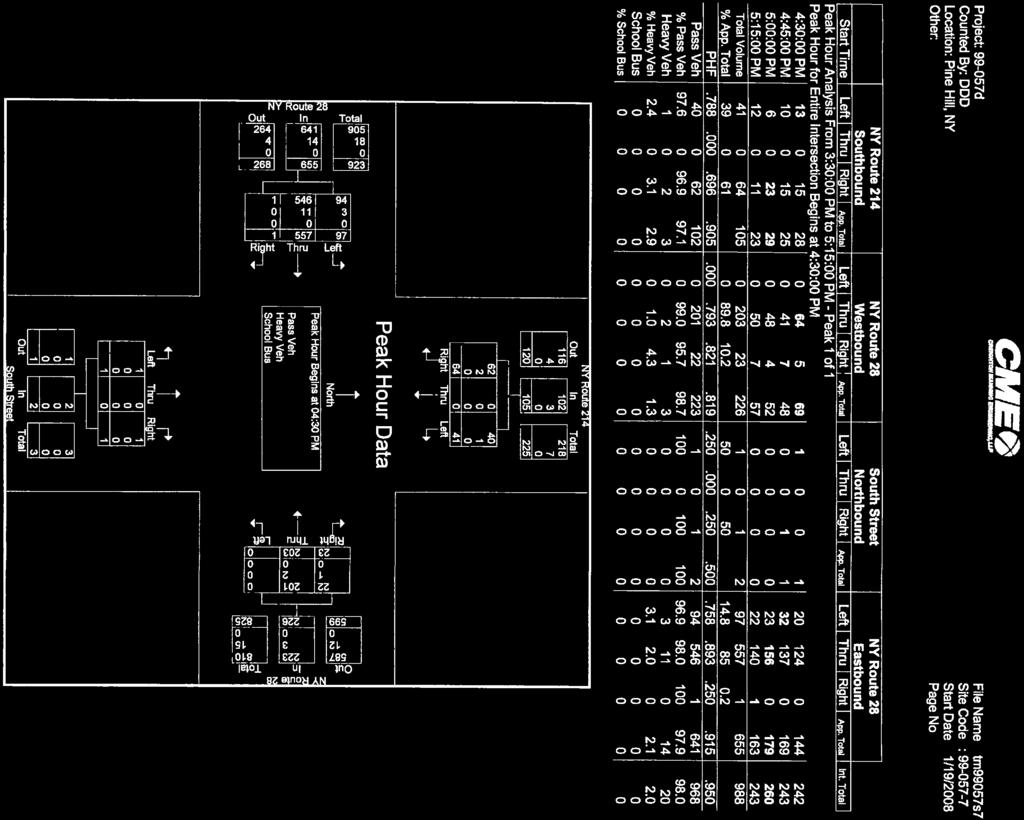
61

62


63

64

65

66
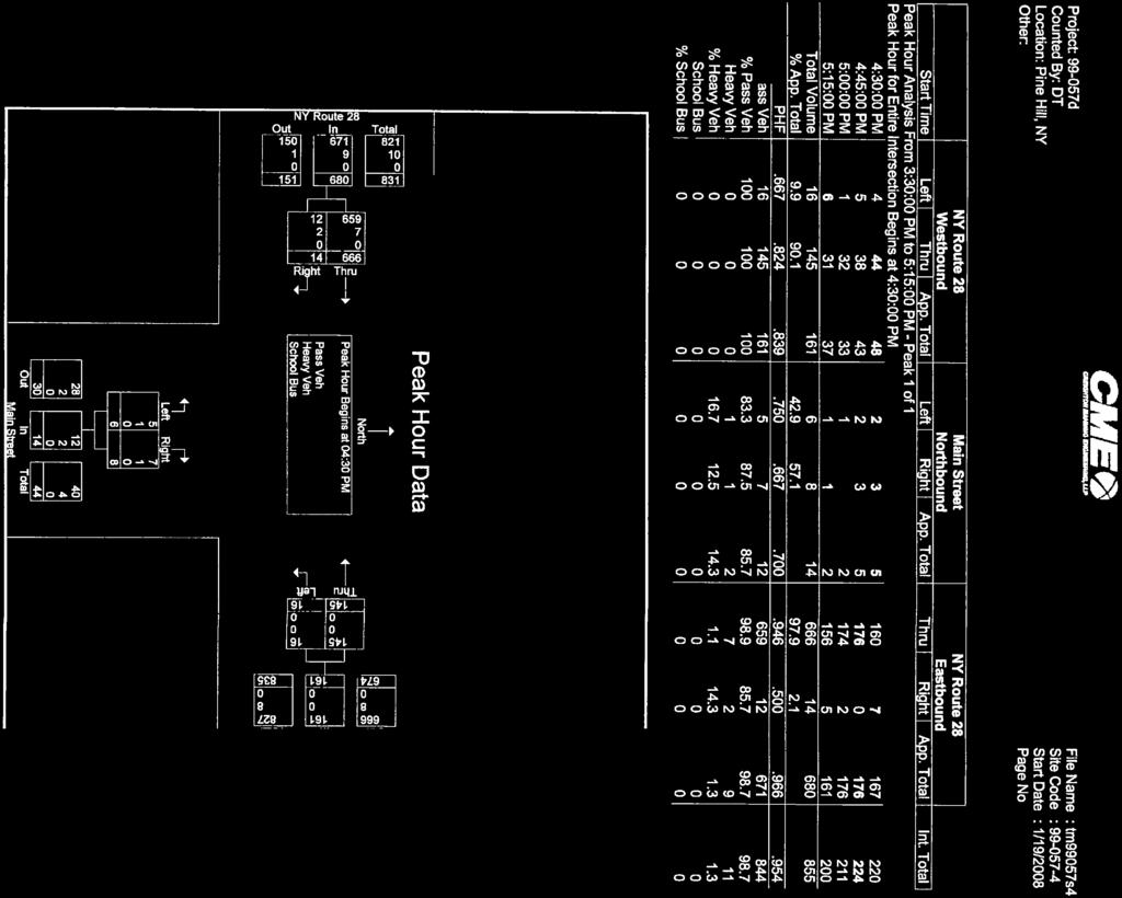
67

68

69

70

71

72

73

74
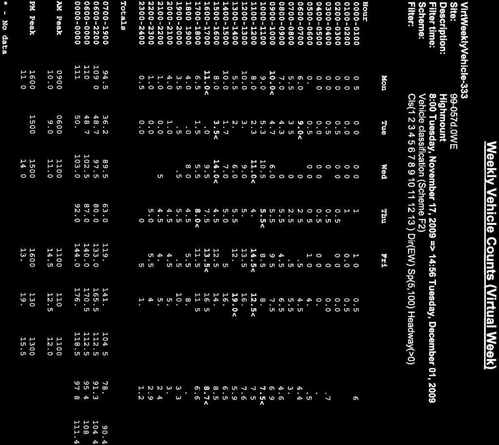
75
76

77
78

79

80
81
82


83
84

85
86

87
88

89
90
91
92

93
94
95

96

97
98 Appendix C Belleayre Mountain Ski Center Traffic Volumes Traffic Impact Study Belleayre Resort at Catskill Park Town of Shandaken and Middletown, New York
99 5 F:\Projects\1999\99-057d\2009\cadd\dgn\FIGS\trf fig.dgn N (13) 88 (13) 5 5 WILDACRES RESORT GUNNISON RD. 28 LOWER DRIVEWAY OWL NEST RD 17 (94) (501) (501) 88 BELLEARYE HIGHMOUNT SPA RESORTS 6 77 BELLEARYE SKI MTN. UPPER DRIVEWAY BELLEAYRE SKI RESORT MAIN ST. 42 (32) (438) 49a (13) (595) (188) 2(344) SOUTH ST. (13) (13) (470) (31) (31) (407) BELLEAYRE MOUNTAIN SKI CENTER UMP EXPANSION BELLEAYRE RESORT AT CATSKILL PARK TOWNS OF SHANDAKEN AND MIDDLETOWN, NEW YORK PROJECT: d DATE: 1/11 FIGURE: C-1
100 Appendix D Level of Service Analysis Traffic Impact Study Belleayre Resort at Catskill Park Town of Shandaken and Middletown, New York
101 LOS Definitions The following is an excerpt from the 2000 Highway Capacity Manual (HCM). Level of Service for Signalized Intersections Level of service for a signalized intersection is defined in terms of control delay, which is a measure of driver discomfort, frustration, fuel consumption, and increased travel time. The delay experienced by a motorist is made up of a number of factors that relate to control, geometrics, traffic, and incidents. Total delay is the difference between the travel time actually experienced and the reference travel time that would result during base conditions: in the absence of traffic control, geometric delay, any incidents, and any other vehicles. Specifically, LOS criteria for traffic signals are stated in terms of the average control delay per vehicle, typically for a 15-minute analysis period. Delay is a complex measure and depends on a number of variables, including the quality of progression, the cycle length, the green ratio, and the v/c ratio for the lane group. Levels of service are defined to represent reasonable ranges in control delay. LOS A describes operations with low control delay, up to 10 s/veh. This LOS occurs when progression is extremely favorable and most vehicles arrive during the green phase. Many vehicles do not stop at all. Short cycle lengths may tend to contribute to low delay. LOS B describes operations with control delay greater than 10 and up to 20 s/veh. This level generally occurs with good progression, short cycle lengths, or both. More vehicles stop than with LOS A, causing higher levels of delay. LOS C describes operations with control delay greater than 20 and up to 35 s/veh. These higher delays may result from only fair progression, longer cycle lengths, or both. Individual cycle failures may begin to appear at this level. Cycle failure occurs when a given green phase does not serve queued vehicles, and overflows occur. The number of vehicles stopping is significant at this level, though many still pass through the intersection without stopping. LOS D describes operations with control delay greater than 35 and up to 55 s/veh. At LOS D, the influence of congestion becomes more noticeable. Longer delays may result from some combination of unfavorable progression, long cycle lengths, and high v/c ratios. Many vehicles stop, and the proportion of vehicles not stopping declines. Individual cycle failures are noticeable. LOS E describes operations with control delay greater than 55 and up to 80 s/veh. These high delay values generally indicate poor progression, long cycle lengths, and high v/c ratios. Individual cycle failures are frequent. LOS F describes operations with control delay in excess of 80 s/veh. This level, considered unacceptable to most drivers, often occurs with oversaturation, that is, when arrival flow rates exceed the capacity of lane groups. It may also occur at high v/c ratios with many individual cycle failures. Poor progression and long cycle lengths may also be contribute significantly to high delay levels.
102 Level of Service Criteria for Unsignalized Intersections Four measures are used to describe the performance of two-way stop controlled intersections: control delay, delay to major street through vehicles, queue length, and v/c ratio. The primary measure that is used to provide an estimate of LOS is control delay. This measure can be estimated for any movement on the minor (i.e., stop-controlled) street. By summing delay estimates for individual movements, a delay estimate for each minor street movement and minor street approach can be achieved. The level of service criteria is given in Exhibit 17-2/22. For all-way stop controlled (AWSC) intersections, the average control delay (in seconds per vehicle) is used as the primary measure of performance. Control delay is the increased time of travel for a vehicle approaching and passing through an AWSC intersection, compared with a free-flow vehicle if it were not required to slow or stop at the intersection. Exhibit 17-2/22: Level-of-Service Criteria for Stop Controlled Intersections Level of Service Control Delay (sec/veh) A < 10.0 B >10.0 and < 15.0 C >15.0 and < 25.0 D >25.0 and < 35.0 E >35.0 and < 50.0 F >50.0


103

104
105


106

107

108


109

110

111

112

113
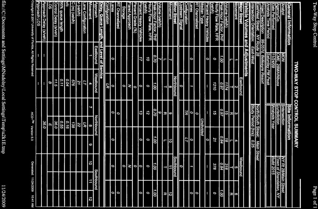
114

115

116

117

118

119
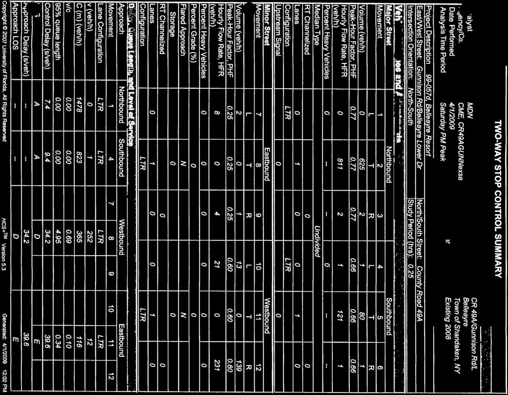


120

121

122


123

124

125

126

127

128
Traffic Impact Analysis Chatham County Grocery Chatham County, NC
 Chatham County Grocery Chatham County, NC TABLE OF CONTENTS 1. INTRODUCTION... 1 1.1. Location and Study Area... 1 1.2. Proposed Land Use and Access... 2 1.3. Adjacent Land Uses... 2 1.4. Existing ways...
Traffic Impact Analysis Walton Acres at Riverwood Athletic Club Clayton, NC
 Traffic Impact Analysis Walton Acres at Riverwood Athletic Club Clayton, NC 1. TABLE OF CONTENTS INTRODUCTION...1 1.1. Site Location and Study Area...1 1.2. Proposed Land Use and Site Access...2 1.3.
5858 N COLLEGE, LLC N College Avenue Traffic Impact Study
 5858 N COLLEGE, LLC nue Traffic Impact Study August 22, 2016 Contents Traffic Impact Study Page Preparer Qualifications... 1 Introduction... 2 Existing Roadway Conditions... 5 Existing Traffic Conditions...
DIMARCO CANANDAIGUA PROPERTIES HOUSING PROJECT CANANDAIGUA, ONTARIO COUNTY, NEW YORK
 TRAFFIC IMPACT STUDY FOR THE DIMARCO CANANDAIGUA PROPERTIES HOUSING PROJECT CANANDAIGUA, ONTARIO COUNTY, NEW YORK MARCH 14, 2017 PREPARED FOR: 1950 Brighton Henrietta Town Line Rd Rochester, NY 14623 PREPARED
Glenn Avenue Corridor Traffic Operational Evaluation
 Glenn Avenue Corridor Traffic Operational Evaluation PREPARED FOR: THE CITY OF AUBURN PREPARED BY: DECEMBER 2007 Glenn Avenue Corridor Study--Auburn, Alabama TABLE OF CONTENTS Introduction... 1 Background
APPENDIX D. Traffic Impact Study Creighton Manning Engineering, LLP
 APPENDIX D Traffic Impact Study Creighton Manning Engineering, LLP Traffic Impact Study Catskill Access Evaluation NYS Thruway Exit 21 Town of Catskill, New York CM Project No. 114-232 Prepared For: Greene
TRAFFIC IMPACT STUDY And A TRAFFIC SIGNAL WARRANT ANALYSIS FOR A SENIOR LIVING AND APARTMENT DEVELOPMENT
 TRAFFIC IMPACT STUDY And A TRAFFIC SIGNAL WARRANT ANALYSIS FOR A SENIOR LIVING AND APARTMENT DEVELOPMENT DEERFIELD TOWNSHIP, WARREN COUNTY, OHIO Nantucket Circle and Montgomery Road () Prepared for: ODLE
Traffic Impact Study. Westlake Elementary School Westlake, Ohio. TMS Engineers, Inc. June 5, 2017
 TMS Engineers, Inc. Traffic Impact Study Westlake Elementary School Westlake, Ohio June 5, 2017 Prepared for: Westlake City Schools - Board of Education 27200 Hilliard Boulevard Westlake, OH 44145 TRAFFIC
Traffic Impact Study WestBranch Residential Development Davidson, NC March 2016
 Traffic Impact Study WestBranch Residential Development Davidson, NC March 216 TRAFFIC IMPACT STUDY FOR THE WestBranch Residential Development LOCATED IN DAVIDSON, NC Prepared For: Lennar Carolinas, LLC
TRANSPORTATION ANALYSIS REPORT US Route 6 Huron, Erie County, Ohio
 TRANSPORTATION ANALYSIS REPORT US Route 6 Huron, Erie County, Ohio December 12, 2012 Prepared for: The City of Huron 417 Main Huron, OH 44839 Providing Practical Experience Technical Excellence and Client
INDUSTRIAL BUILDING 3009 HAWTHORNE ROAD CITY OF OTTAWA TRANSPORTATION OVERVIEW REVISED. Prepared for: Canada Inc.
 INDUSTRIAL BUILDING 3009 HAWTHORNE ROAD CITY OF OTTAWA TRANSPORTATION OVERVIEW REVISED Prepared for: 7849648 Canada Inc. Octiober 1, 2015 114-598 Overview_2.doc D. J. Halpenny & Associates Ltd. Consulting
MEETING FACILITY 2901 GIBFORD DRIVE CITY OF OTTAWA TRANSPORTATION BRIEF. Prepared for: Holiday Inn Express 2881 Gibford Drive Ottawa, ON K1V 2L9
 MEETING FACILITY 2901 GIBFORD DRIVE CITY OF OTTAWA TRANSPORTATION BRIEF Prepared for: Holiday Inn Express 2881 Gibford Drive Ottawa, ON K1V 2L9 December 18, 2012 112-566 Brief_1.doc D. J. Halpenny & Associates
TRAFFIC IMPACT STUDY COMPREHENSIVE UPDATE TOWN OF THOMPSON S STATION, TENNESSEE PREPARED FOR: THE TOWN OF THOMPSON S STATION
 TRAFFIC IMPACT STUDY COMPREHENSIVE UPDATE TOWN OF THOMPSON S STATION, TENNESSEE PREPARED FOR: THE TOWN OF THOMPSON S STATION Transportation Consultants, LLC 1101 17 TH AVENUE SOUTH NASHVILLE, TN 37212
HILTON GARDEN INN HOTEL HOTEL EXPANSION 2400 ALERT ROAD, OTTAWA TRANSPORTATION BRIEF. Prepared for:
 HILTON GARDEN INN HOTEL HOTEL EXPANSION 2400 ALERT ROAD, OTTAWA TRANSPORTATION BRIEF Prepared for: Bona Building & Management Co. Ltd. Place Vanier, 333 North River Road Vanier, Ontario K1L 8B9 October
Traffic Impact Study. Roderick Place Columbia Pike Thompson s Station, TN. Transportation Group, LLC Traffic Engineering and Planning
 F i s c h b a c h Transportation Group, LLC Traffic Engineering and Planning Traffic Impact Study Roderick Place Columbia Pike Thompson s Station, TN Prepared March 2016 Ms. Gillian L. Fischbach, P.E.,
TRAFFIC IMPACT STUDY
 TRAFFIC IMPACT STUDY for the GLEN ELLEN COUNTRY CLUB SENIOR RESIDENTIAL REDEVELOPMENT 84 Millis, Massachusetts Prepared by: McMahon Associates, Inc. Prepared for: Toll Brothers, Inc. August 216 DRAFT
INDUSTRIAL BUILDING 1660 COMSTOCK ROAD CITY OF OTTAWA TRANSPORTATION OVERVIEW. Prepared for:
 INDUSTRIAL BUILDING 1660 COMSTOCK ROAD CITY OF OTTAWA TRANSPORTATION OVERVIEW Prepared for: Simluc Contractors Limited 2550 Blackwell Street, Ottawa K1B 5R1 October 18, 2013 113-584 Overview_1.doc D. J.
Donahue Drive Corridor Traffic Operational Evaluation
 Donahue Drive Corridor Traffic Operational Evaluation PREPARED FOR: THE CITY OF AUBURN PREPARED BY: JANUARY 2007 Donahue Drive Corridor Study--Auburn, Alabama TABLE OF CONTENTS Introduction... 1 Background
Chapter 4 Traffic Analysis
 Chapter 4 Traffic Analysis PURPOSE The traffic analysis component of the K-68 Corridor Management Plan incorporates information on the existing transportation network, such as traffic volumes and intersection
TRAFFIC IMPACT STUDY CRITERIA
 Chapter 6 - TRAFFIC IMPACT STUDY CRITERIA 6.1 GENERAL PROVISIONS 6.1.1. Purpose: The purpose of this document is to outline a standard format for preparing a traffic impact study in the City of Steamboat
URBAN QUARRY HEADQUARTERS 2717 STEVENAGE DRIVE CITY OF OTTAWA TRANSPORTATION OVERVIEW. Prepared for: Urban Quarry 4123 Belgreen Drive, Ottawa K1G 3N2
 URBAN QUARRY HEADQUARTERS 2717 STEVENAGE DRIVE CITY OF OTTAWA TRANSPORTATION OVERVIEW Prepared for: Urban Quarry 4123 Belgreen Drive, Ottawa K1G 3N2 February 27, 2014 113-584 Overview_1.doc D. J. Halpenny
FINAL Albertville Business Park AUAR Update Traffic Study
 FINAL Albertville Business Park AUAR Update Traffic Study Prepared for City of Albertville, MN July 20, 2017 SRF No. 10060.00 Table of Contents Introduction... 1 Existing Conditions... 1 Data Collection...
TRAFFIC IMPACT ANALYSIS
 TRAFFIC IMPACT ANALYSIS FOR THE CHAMPAIGN UNIT#4 SCHOOL DISTRICT PROPOSED HIGH SCHOOL (SPALDING PARK SITE) IN THE CITY OF CHAMPAIGN Final Report Champaign Urbana Urbanized Area Transportation Study 6/24/2014
2. Existing Conditions
 2. Existing Conditions The existing traffic and parking conditions on the site and the surrounding area were reviewed based on the study methodology in Section 1.2. 2.1 Existing Land Use The portion of
NEW YORK CENTRAL PARK SUBDIVISION BLAIS STREET/ST-PIERRE STREET EMBRUN, ONTARIO TRAFFIC IMPACT STUDY. Prepared for:
 NEW YORK CENTRAL PARK SUBDIVISION BLAIS STREET/ST-PIERRE STREET EMBRUN, ONTARIO TRAFFIC IMPACT STUDY Prepared for: Solidex Holdings Limited & Investissement Maurice Lemieux Investments Attn: Mr. Anthony
Subject: Solberg Avenue / I-229 Grade Separation: Traffic Analysis
 MEMORANDUM Transportation Bill Troe, AICP Jason Carbee, AICP 12120 Shamrock Plaza Suite 300 Omaha, NE 68154 (402) 334-8181 (402) 334-1984 (Fax) To: Project File Date: Subject: Solberg Avenue / I-229 Grade
MEDICAL/OFFICE BUILDING 1637 BANK STREET OTTAWA, ONTARIO TRANSPORTATION OVERVIEW. Prepared for:
 MEDICAL/OFFICE BUILDING 1637 BANK STREET OTTAWA, ONTARIO TRANSPORTATION OVERVIEW Prepared for: 2434984 Ontario Inc. 13-5510 Canotek Road Ottawa, Ontario K1J 9J5 June 4, 2015 115-613 Report_2.doc D. J.
OFFICE/RETAIL DEVELOPMENT 1625 BANK STREET OTTAWA, ONTARIO TRANSPORTATION BRIEF. Prepared for: Canada Inc.
 OFFICE/RETAIL DEVELOPMENT 1625 BANK STREET OTTAWA, ONTARIO TRANSPORTATION BRIEF Prepared for: 9402209 Canada Inc. December 15, 2015 115-625 Report_2.doc D. J. Halpenny & Associates Ltd. Consulting Transportation
Henderson Avenue Mixed-Use Development
 Zoning Case: Z145-3 Traffic Impact Analysis Henderson Avenue Mixed-Use Development Dallas, TX October 26 th, 216 Kimley-Horn and Associates, Inc. Dallas, Texas Project #644827 Registered Firm F-928 Traffic
Troutbeck Farm Development
 Troutbeck Farm Development Willistown Township, Chester County PA For Submission To: Willistown Township Last Revised: October, 4 TPD# INLM.A. 5 E. High Street Suite 65 Pottstown, PA 9464 6.36.3 TPD@TrafficPD.com
Shockoe Bottom Preliminary Traffic and Parking Analysis
 Shockoe Bottom Preliminary Traffic and Parking Analysis Richmond, Virginia August 14, 2013 Prepared For City of Richmond Department of Public Works Prepared By 1001 Boulders Pkwy Suite 300, Richmond, VA
PINESTONE TRAFFIC IMPACT STUDY Travelers Rest, South Carolina
 PINESTONE TRAFFIC IMPACT STUDY Travelers Rest, South Carolina Prepared for Longbranch Development Prepared by January 13, 219 ii Table of Contents Subject Page Signature Page... i Table of Contents...
FINAL DESIGN TRAFFIC TECHNICAL MEMORANDUM
 FINAL DESIGN TRAFFIC TECHNICAL MEMORANDUM July 2014 FINAL (SR 43) Project Development and Environment Study From State Road 60 (Adamo Drive) to I-4 (SR 400) Hillsborough County, Florida Work Program Item
Truck Climbing Lane Traffic Justification Report
 ROUTE 7 (HARRY BYRD HIGHWAY) WESTBOUND FROM WEST MARKET STREET TO ROUTE 9 (CHARLES TOWN PIKE) Truck Climbing Lane Traffic Justification Report Project No. 6007-053-133, P 101 Ι UPC No. 58599 Prepared by:
Traffic Circulation Study for Neighborhood Southwest of Mockingbird Lane and Airline Road, Highland Park, Texas
 ARIZONA TEXAS NEW MEXICO OKLAHOMA February 13, 2015 Mr. Meran Dadgostar P.E., R.S. Town of Highland Park 4700 Drexel Dr. Highland Park, Texas 75205 Re: Traffic Circulation Study for Neighborhood Southwest
Traffic Impact Statement
 Traffic Impact Statement Mixed Use Development, US 41 and Old Trail Drive aka Tide-Starbucks 4900 9 th Street North General Development Site Plan (GDSP) Collier County, FL 10/6/2015 Prepared for: Prepared
OTTAWA TRAIN YARDS PHASE 3 DEVELOPMENT CITY OF OTTAWA TRANSPORTATION IMPACT STUDY. Prepared for:
 OTTAWA TRAIN YARDS PHASE 3 DEVELOPMENT CITY OF OTTAWA TRANSPORTATION IMPACT STUDY Prepared for: The Ottawa Train Yards Inc. 223 Colonnade Road South, Suite 212 Nepean, Ontario K2E 7K3 January 17, 2012
DRAFT. Corridor study. Honeysuckle Road. October Prepared for the City of Dothan, AL. Prepared by Gresham, Smith and Partners
 DRAFT Corridor study Honeysuckle Road October 2017 Prepared for the City of Dothan, AL Prepared by TABLE OF CONTENTS SECTION I... 1 STUDY SUMMARY... 1 INTRODUCTION... 1 CONCLUSIONS... 5 SECTION II... 7
Technical Memorandum TRAFFIC IMPACT STUDY. RIDLEY ROAD CONVENIENCE STORE Southampton County, VA. Prepared for: Mr. David Williams.
 Technical Memorandum TRFFIC IMPCT STUDY RIDLEY ROD CONVENIENCE STORE Southampton County, V Prepared for: Mr. David Williams By: Charles Smith, P.E., PTOE EPR Charlottesville, V July 2014 1 TBLE OF CONTENTS
Gateway Transportation Study
 Gateway Transportation Study Amherst, Massachusetts SUBMITTED TO University of Massachusetts Amherst Town of Amherst SUBMITTED BY Vanasse Hangen Brustlin, Inc. Watertown, Massachusetts March 213 Back of
Table of Contents FIGURES TABLES APPENDICES. Traffic Impact Study Hudson Street Parking Garage MC Project No.: A Table of Contents
 Traffic Impact Study Hudson Street Parking Garage MC Project No.: 151714A Table of Contents Table of Contents I. INTRODUCTION... 2 II. EXISTING CONDITIONS... 5 III. 215 EXISTING TRAFFIC CONDITIONS... 6
HOLIDAY INN HOTEL 235 KING EDWARD AVENUE CITY OF OTTAWA TRANSPORTATION BRIEF. Prepared for:
 HOLIDAY INN HOTEL 235 KING EDWARD AVENUE CITY OF OTTAWA TRANSPORTATION BRIEF Prepared for: Momentum Planning & Communications 1165 Greenlawn Crescent Ottawa, ON K1L 6C2 June 29, 2015 115-618 Brief_1.doc
METHODOLOGY. Signalized Intersection Average Control Delay (sec/veh)
") Chapter 5 Traffic Analysis 5.1 SUMMARY US /West 6 th Street assumes a unique role in the Lawrence Douglas County transportation system. This principal arterial street currently conveys commuter traffic
Chapter 5 Traffic Analysis 5.1 SUMMARY US /West 6 th Street assumes a unique role in the Lawrence Douglas County transportation system. This principal arterial street currently conveys commuter traffic
FAIRFIELD INN & SUITES HOTEL 135 THAD JOHNSON PRIVATE OTTAWA TRANSPORTATION BRIEF. Prepared for:
 FAIRFIELD INN & SUITES HOTEL 135 THAD JOHNSON PRIVATE OTTAWA TRANSPORTATION BRIEF Prepared for: Bona Building & Management Co. Ltd. Place Vanier, 333 North River Road Vanier, Ontario K1L 8B9 August 12,
Walmart (Store # ) 60 th Street North and Marion Road Sioux Falls, South Dakota
 60 th Street North and Marion Road Sioux Falls, South Dakota") Walmart (Store #4865-00) 60 th Street North and Marion Road Sioux Falls, South Dakota Prepared for: Wal-Mart Stores, Inc. Bentonville, Arkansas Prepared by: Kimley-Horn and Associates, Inc. ã2013 Kimley-Horn
Walmart (Store #4865-00) 60 th Street North and Marion Road Sioux Falls, South Dakota Prepared for: Wal-Mart Stores, Inc. Bentonville, Arkansas Prepared by: Kimley-Horn and Associates, Inc. ã2013 Kimley-Horn
Route 28 (South Orleans Road)/Route 39 (Harwich Road)/Quanset Road Intersection
/Route 39 (Harwich Road)/Quanset Road Intersection") TRAFFIC FEASIBILITY STUDY Route 28 (South Orleans Road)/Route 39 (Harwich Road)/Quanset Road Intersection Orleans, Massachusetts Prepared for: Town of Orleans Prepared by: Fay, Spofford & Thorndike, LLC
TRAFFIC FEASIBILITY STUDY Route 28 (South Orleans Road)/Route 39 (Harwich Road)/Quanset Road Intersection Orleans, Massachusetts Prepared for: Town of Orleans Prepared by: Fay, Spofford & Thorndike, LLC
TRAFFIC ASSESSMENT River Edge Colorado
 TRAFFIC ASSESSMENT River Edge Colorado Submitted by: Fehr & Peers 621 17th Street, Ste. 231 Denver, CO 8293 (33) 296-43 December, 21 App. M-2 Traffic Assessment River Edge Colorado December 21 TABLE OF
THIS PAGE LEFT BLANK INTENTIONALLY
 GA SR 25 Spur at Canal Road Transportation Impact Analysis PREPARED FOR GLYNN COUNTY, GEORGIA 1725 Reynolds Street, Suite 300 Brunswick, Georgia 31520 PREPARED BY 217 Arrowhead Boulevard Suite 26 Jonesboro,
ALLEY 24 TRAFFIC STUDY
 ALLEY 24 TRAFFIC STUDY in City of Frostburg, Maryland January 2013 3566 Teays Valley Road Hurricane, WV Office: (304) 397-5508 www.denniscorporation.com Alley 24 Traffic Study January 2013 Frostburg, Maryland
QUICKIE C STORE AND GAS BAR 1780 HERON ROAD OTTAWA, ONTARIO TRANSPORTATION BRIEF. Prepared for:
 QUICKIE C STORE AND GAS BAR 1780 HERON ROAD OTTAWA, ONTARIO TRANSPORTATION BRIEF Prepared for: Quickie Convenience Stores Larny Holdings Ltd. c/o PBC Group April 15, 2015 115-615 Report_1.doc D. J. Halpenny
Traffic Impact Study Little Egypt Road Development Denver, North Carolina June 2017
 Traffic Impact Study Little Egypt Road Development Denver, North arolina June 2017 N. Little Egypt Road DQ\ QDQFLQJ VDOHV RU RWKHU SHUIRUPDQFH EDVHG FULWHULD Proposed Site Driveways Site Driveway 1 TRAFFI
Marina Loft (DRC 51-R-12)
") Marina Loft (DRC 51-R-12) traffic study prepared for: Cymbal Development OCtober 2012 Traf Tech October 1, 2012 Mr. Asi Cymbal - President Cymbal Development 3470 North Miami Avenue Upper Suite Miami,
Marina Loft (DRC 51-R-12) traffic study prepared for: Cymbal Development OCtober 2012 Traf Tech October 1, 2012 Mr. Asi Cymbal - President Cymbal Development 3470 North Miami Avenue Upper Suite Miami,
1609 E. FRANKLIN STREET HOTEL TRAFFIC IMPACT STUDY EXECUTIVE SUMMARY
 1609 E. FRANKLIN STREET HOTEL TRAFFIC IMPACT STUDY EXECUTIVE SUMMARY Prepared for: The Town of Chapel Hill Public Works Department Traffic Engineering Division Prepared by: HNTB North Carolina, PC 343
Highway 111 Corridor Study
 Highway 111 Corridor Study June, 2009 LINCOLN CO. HWY 111 CORRIDOR STUDY Draft Study Tea, South Dakota Prepared for City of Tea Sioux Falls Metropolitan Planning Organization Prepared by HDR Engineering,
APPENDIX E: Transportation Technical Report
 New Jersey Pennsylvania Lackawanna Cut-Off Passenger Rail Service Reston Project Environmental Assessment APPENDIX E: Transportation Technical Report E.1 Introduction As part of the overall environmental
TRAFFIC STUDY GUIDELINES Clarksville Street Department
 TRAFFIC STUDY GUIDELINES Clarksville Street Department 9/1/2009 Introduction Traffic studies are used to help the city determine potential impacts to the operation of the surrounding roadway network. Two
Traffic Signal Redesign 50% Design Report
 Traffic Signal Redesign 50% Design Report Joseph Davis, Jace Elkins, Jordan Weyrauch and Zach Crimmins CENE 486 Capstone J3Z Engineering March 10 th, 2016 Table of Contents 1.0 Project Description...1
FRONT RANGE CROSSINGS TRAFFIC IMPACT STUDY
 FRONT RANGE CROSSINGS TRAFFIC IMPACT STUDY Prepared for: City of Thornton And Colorado Department of Transportation Prepared by: 11 Blake Street, Suite 2 Denver, Colorado 822 Contact: Brian Bern, PE, PTOE
Volume 1 Traffic Impact Analysis. Texas Odyssey TIA Dallas, Texas. Kimley-Horn and Associates, Inc. Dallas, Texas. May 23, 2018
 Volume 1 Traffic Impact Analysis Texas Odyssey TIA Dallas, Texas May 23, 2018 Kimley-Horn and Associates, Inc. Dallas, Texas Project #064529800 Registered Firm F-928 Traffic Impact Analysis Texas Odyssey
Appendix C. NORTH METRO STATION AREA TRAFFIC IMPACT STATEMENT 88th Avenue Station
 Appendix C NORTH METRO STATION AREA TRAFFIC IMPACT STATEMENT 88th Avenue Station Prepared for: Regional Transportation Department and URS Corporation as part of the North Metro EIS David Evans and Associates,
Cricket Valley Energy Project Dover, NY Updated Traffic Impact Study
 Updated Traffic Impact Study Community Resources 6.3A Traffic and Transportation Amended This amended Traffic Study incorporates comments from NYSDOT, provided after their review of the original Traffic
Traffic Impact and Access Study PROPOSED DURKEE FARM ESTATES. Foster Street Littleton, Massachusetts. Prepared for: Grimes Road, LLC.
 Traffic Impact and Access Study PROPOSED DURKEE FARM ESTATES Foster Street Littleton, Massachusetts Prepared for: Grimes Road, LLC. Westford, MA Prepared by: MDM Transportation Consultants, Inc. 28 Lord
Cheyenne Metropolitan Planning Organization
 Dell Range Boulevard Corridor Study PHASE II SECTION 20 DRAFT Prepared for: Cheyenne Metropolitan Planning Organization November 20, 2015 (Section 20 is bordered by Powderhouse Road on the west, Storey
Public Involvement Meeting Tuesday, June 13, Albany Shaker Road Corridor Study
 Public Involvement Meeting Tuesday, June 13, 2017 Albany Shaker Road Corridor Study Agenda / Meeting Outline 1. Introduce the project 2. Complete Streets 3. Share/confirm our findings 4. Your Opinion 5.
Capital Region Council of Governments
 March 23, 2018 Capital Region Council of Governments PROJECT CONCEPT REPORT Realignment of Swamp and Northfield Road s approaches to Route 44 (Boston Turnpike) Town of Coventry SUMMARY: The Town of Coventry
Transportation Impact Study for Abington Terrace
 Transportation Impact Study for Abington Terrace Abington Township, Montgomery County, PA Sandy A. Koza, P.E., PTOE PA PE License Number PE059911 Prepared by McMahon Associates, Inc. 425 Commerce Drive,
Grant Avenue Streetscape
 REPORT TYPE GOES HERE Grant Avenue Streetscape PREPARED FOR City of Manassas 9027 Center Street Manassas, VA 20110 PREPARED BY 8300 Boone Boulevard Suite 700 Vienna, Virginia 22182 571.389.8121 July 31,
Figure 1: Vicinity Map of the Study Area
 ARIZONA TEXAS NEW MEXICO OKLAHOMA May 5, 2016 Mr. Anthony Beach, P.E. BSP Engineers 4800 Lakewood Drive, Suite 4 Waco, Texas 76710 Re: Intersection and Access Analysis along Business 190 in Copperas Cove
Date: September 7, Project #: Re: Spaulding Youth Center Northfield, NH Property. Traffic Impact Study
 To: Ms. Susan C. Ryan Spaulding Youth Center 72 Spaulding Road Northfield, NH 03276 Date: September 7, 2017 Project #: 52455.00 From: Robin Bousa Director of Transportation Systems Re: Spaulding Youth
MEMORANDUM. DATE March 1, 2012 TO Town of Milton Mark Abbott, Seth Asante, and Efi Pagitsas Boston Region MPO Staff
 MEMORANDUM DATE March 1, 212 TO Town of Milton FROM RE Mark Abbott, Seth Asante, and Efi Pagitsas Boston Region MPO Staff FFY 211 Safety and Operations Analyses at Selected Boston Region MPO Intersections:
DUNBOW ROAD FUNCTIONAL PLANNING
 DUNBOW ROAD FUNCTIONAL PLANNING Final Report August 3, 216 #31, 316 5th Avenue NE Calgary, AB T2A 6K4 Phone: 43.273.91 Fax: 43.273.344 wattconsultinggroup.com Dunbow Road Functional Planning Final Report
Waterford Lakes Small Area Study
 Waterford Lakes Small Area Study Existing Traffic Conditions PREPARED FOR: ORANGE COUNTY PUBLIC WORKS DEPARTMENT TRAFFIC ENGINEERING DIVISION ORLANDO, FLORIDA PREPARED WITH: INWOOD CONSULTING ENGINEERS
STILLWATER AVENUE CORRIDOR STUDY Old Town, Maine
 Draft Study STILLWATER AVENUE CORRIDOR STUDY Old Town, Maine SUBMITTED TO: BANGOR AREA COMPREHENSIVE TRANSPORTATION SYSTEM SUBMITTED BY: I MAY 23, 2017 DRAFT STILLWATER AVENUE STUDY FINAL REPORT Table
Include autoturn exhibits of WB-67 trucks at each roundabout.
 1 Along the through path, the desired relationship is R1>R2
VIVA RETIREMENT COMMUNITIES OAKVILLE TRAFFIC IMPACT STUDY
 VIVA RETIREMENT COMMUNITIES OAKVILLE TRAFFIC IMPACT STUDY VIVA RETIREMENT COMMUNITIES OAKVILLE TRAFFIC IMPACT STUDY DECEMBER 2012 READ, VOORHEES & ASSOCIATES TORONTO, ONTARIO Read, Voorhees & Associates
Water Street Corridor Streetscape TRAFFIC STUDY
 TRAFFIC STUDY November 12, 2015 WATER STREET CORRIDOR STREETSCAPE IMPROVEMENTS PROJECT BOROUGH OF MANHATTAN EDC Contract No.: 48480002 Prepared for: Prepared by: TABLE OF CONTENTS I. INTRODUCTION/ EXECUTIVE
List of Attachments. Location Map... Site Plan... City of Lake Elsinore Circulation Element... City of Lake Elsinore Roadway Cross-Sections...
 List of Attachments Exhibits Location Map... Site Plan... City of Lake Elsinore Circulation Element... City of Lake Elsinore Roadway Cross-Sections... Existing Lane Geometry and Traffic Controls... Existing
Project Report. South Kirkwood Road Traffic Study. Meadows Place, TX October 9, 2015
 Meadows Place, TX October 9, 2015 Contents 1 Introduction... 1 2 Data Collection... 1 3 Existing Roadway Network... 2 4 Traffic Volume Development... 2 5 Warrant Analysis... 3 6 Traffic Control Alternative
Harrah s Station Square Casino
 Transportation Analysis Harrah s Station Square Casino Pittsburgh, Pennsylvania Submitted To: City of Pittsburgh and Pennsylvania Gaming Control Board Prepared By: DKS Associates GAI Consultants December
TRAFFIC IMPACT STUDY. Creekside Thornton, Colorado. For. August 2015 November 2015 Revised: August Prepared for:
 TRAFFIC IMPACT STUDY For Creekside Thornton, Colorado August 215 November 215 Revised: August 216 Prepared for: Jansen Strawn Consulting Engineers 45 West 2 nd Avenue Denver, Colorado 8223 Prepared by:
Figure 1: East West Connector Alignment Alternatives Concept Drawing
 Page 2 of 9 Figure 1: East West Connector Alignment Alternatives Concept Drawing The Montebello Drive extension will run north south and connect Wilsonville Road to the Boones Ferry Road to Brown Road
Draft Report. Traffic Impact Study. Superstore, Wal-Mart, and Kent Development. Yarmouth, Nova Scotia. Prepared for
 oad & Traffic Management Road & Traffic Management R Atlantic Traffic Engineering Specialists Draft Report Traffic Impact Study Superstore, Wal-Mart, and Kent Development Yarmouth, Nova Scotia Prepared
THE LANDMARK AT TALBOT PARK
 TRAFFIC IMPACT STUDY FOR THE LANDMARK AT TALBOT PARK IN NORFOLK, VA INTERMODAL ENGINEERING, P.C. OCTOBER, 200 The Landmark at Talbot Park is a proposed redevelopment of the existing apartments along the
APPENDIXB. Traffic Operations Technical Memorandum
 APPENDIXB Traffic Operations Technical Memorandum Environmental Assessment - Lincoln County, SD 85 th Street: Sundowner Avenue to Louise Avenue November 2017 MEMORANDUM Transportation Jim Kollbaum, PE
Evaluation of M-99 (Broad Street) Road Diet and Intersection Operational Investigation
 Road Diet and Intersection Operational Investigation") Evaluation of M-99 (Broad Street) Road Diet and Intersection Operational Investigation City of Hillsdale, Hillsdale County, Michigan June 16, 2016 Final Report Prepared for City of Hillsdale 97 North Broad
Evaluation of M-99 (Broad Street) Road Diet and Intersection Operational Investigation City of Hillsdale, Hillsdale County, Michigan June 16, 2016 Final Report Prepared for City of Hillsdale 97 North Broad
Traffic Signal Optimization Project (Hosman Road) (Future Coordinated Corridor)
 (Future Coordinated Corridor)") Onondaga County Department of Transportation Traffic Signal Optimization Project (Hosman Road) (Future Coordinated Corridor) Prepared for: Syracuse Metropolitan Transportation Council 126 North Salina
Onondaga County Department of Transportation Traffic Signal Optimization Project (Hosman Road) (Future Coordinated Corridor) Prepared for: Syracuse Metropolitan Transportation Council 126 North Salina
Intersection Traffic Control Feasibility Study
 Intersection Traffic Control Feasibility Study CSAH 9 at CSAH 60 (185th Avenue) Prepared For: Dakota County Transportation Department Western Service Center 14955 Galaxie Avenue, 3rd Floor Apple Valley,
COMMERCIAL DEVELOPMENT 2015 ROBERTSON ROAD OTTAWA, ONTARIO TRANSPORTATION BRIEF. Prepared for:
 COMMERCIAL DEVELOPMENT 2015 ROBERTSON ROAD OTTAWA, ONTARIO TRANSPORTATION BRIEF Prepared for: First Bay Properties Inc. 311 Richmond Road, Suite 203 Ottawa, ON K1Z 6X3 August 8, 2017 117-663 Brief_1.doc
2016 Church Street Access Study. 100 Clinton Square 126 North Salina Street, Suite 100 Syracuse, NY
 2016 Church Street Access Study 100 Clinton Square 126 North Salina Street, Suite 100 Syracuse, NY 13202 www.smtcmpo.org Syracuse Metropolitan Transportation Council Final Report February 23, 2016 This
King Soopers #116 Thornton, Colorado
 Traffic Impact Study King Soopers #116 Thornton, Colorado Prepared for: Galloway & Company, Inc. 1.0 EXECUTIVE SUMMARY King Soopers #116, a grocery marketplace anchored commercial development, is proposed
APARTMENT BUILDING DEVELOPMENT 1161 HERON ROAD OTTAWA, ONTARIO TRANSPORTATION IMPACT STUDY. Prepared for:
 APARTMENT BUILDING DEVELOPMENT 1161 HERON ROAD OTTAWA, ONTARIO TRANSPORTATION IMPACT STUDY Prepared for: 1649362 Ontario Inc. c/o Manor Park Management 231 Brittany Drive, Suite D Ottawa ON K1K 0R8 July
ORLEANS GARDENS SHOPPING CENTRE 1615 ORLEANS BOULEVARD CITY OF OTTAWA, ONTARIO TRANSPORTATION IMPACT STUDY. Prepared for:
 ORLEANS GARDENS SHOPPING CENTRE 1615 ORLEANS BOULEVARD CITY OF OTTAWA, ONTARIO TRANSPORTATION IMPACT STUDY Prepared for: Orleans Gardens Shopping Centre Inc. 2851 John Street, Suite 1 Markham, ON K3R 5R7
JONESBORO HIGHWAY 63 HIGHWAY 18 CONNECTOR STUDY
 JONESBORO HIGHWAY 63 HIGHWAY 18 CONNECTOR STUDY Craighead County May 2007 JONESBORO HIGHWAY 63 HIGHWAY 18 CONNECTOR STUDY Craighead County May 2007 Prepared by Planning and Research Division Arkansas State
Magnolia Place. Traffic Impact Analysis. Prepared for: City of San Mateo. Prepared by: Hexagon Transportation Consultants, Inc.
 Magnolia Place Traffic Impact Analysis Prepared for: City of San Mateo Prepared by: Hexagon Transportation Consultants, Inc. Updated January 4, 2010 Table of Contents 1. Introduction...1 2. Existing Conditions...6
TABLE OF CONTENTS TABLE OF CONTENTS... I APPENDICES... III LIST OF EXHIBITS... V LIST OF TABLES... VII LIST OF ABBREVIATED TERMS...
 TABLE OF CONTENTS TABLE OF CONTENTS... I APPENDICES... III LIST OF EXHIBITS... V LIST OF TABLES... VII LIST OF ABBREVIATED TERMS... IX 1 INTRODUCTION... 1 1.1 Project Overview... 1 1.2 Analysis Scenarios...
4.11 TRANSPORTATION 4.11 TRANSPORTATION Environmental Setting Intersection, Roadway, and Freeway Evaluation Methodology
 4.11 TRANSPORTATION This section describes the road transportation system in the vicinity of the proposed Project and the potential impacts to this system from the proposed Project. The analysis in this
6060 North Central Expressway Mixed-Use Site Dallas, Texas
 Volume 1 Traffic Impact Analysis 6060 North Central Expressway Mixed-Use Site Dallas, Texas April 30, 2018 Kimley-Horn and Associates, Inc. Dallas, Texas Project #063238300 Registered Firm F-928 Traffic
List of Exhibits...ii
 One Brickell Traffic Study TABLE OF CONTENTS List of Exhibits...ii EXECUTIVE SUMMARY...1 1. INTRODUCTION...2 1.1 Study Area...2 1.2 Study Objective...5 2. EXISTING TRAFFIC CONDITIONS...6 2.1 Data Collection...6
HENDERSON DEVELOPMENT 213, 217, 221, 221 ½, 223 HENDERSON AVENUE and 65 TEMPLETON STREET OTTAWA, ONTARIO TRANSPORTATION OVERVIEW.
 HENDERSON DEVELOPMENT 213, 217, 221, 221 ½, 223 HENDERSON AVENUE and 65 TEMPLETON STREET OTTAWA, ONTARIO TRANSPORTATION OVERVIEW Prepared for: 2294170 Ontario Inc. February 2, 2017 117-652 Report_1.doc
South Albion-Bolton Community Plan North Hill Supermarket Transportation Study Part B: Evaluation of Alternatives
 Community Plan North Hill Supermarket Transportation Study Part B: Evaluation of Alternatives Prepared for: The Town of Caledon August 9 Transportation Solutions Ltd. 43 Forest Road Cambridge, ON N1S 3B4