Technical Appendices Transportation Appendix. Transportation Contents
|
|
|
- Jocelin Gibbs
- 6 years ago
- Views:
Transcription

1 Technical Appendix Cntents Intrductin... T Appendix 4 Cnditins and Trends... T Appendix 5 Land Uses and Key Destinatins... T Appendix 5 Dwntwn Bremertn... T Appendix 6 Kitsap Cnference Center... T Appendix 6 Bremertn Center & Ferry Terminal... T Appendix 6 Schls... T Appendix 6 Olympic Cllege... T Appendix 7 Parks and Recreatin Areas... T Appendix 7 Naval Base Kitsap... T Appendix 8 Netwrk... T Appendix 10 Existing Pedestrian Facilities... T Appendix 13 Existing Bicycle Facilities... T Appendix 14 Kayaking... T Appendix 16 Public Transit... T Appendix 17 Freight and Aviatin... T Appendix 21 Mtr Vehicles... T Appendix 23 Opprtunities and Challenges... T Appendix 25 Netwrk Cnnectivity... T Appendix 25 Reginal Grwth... T Appendix 26 Puget Sund Industrial Center (PSIC)... T Appendix 26 Safe Rutes fr All, Especially Pedestrians and Bicycles... T Appendix 27 Dwntwn Circulatin... T Appendix 31 Cmmunity Outreach... T Appendix 33 T Appendix 1
2 Technical Appendix Stakehlder Meeting... T Appendix 33 Public Meeting... T Appendix 34 Intrductin t the Layered Netwrk... T Appendix 35 Mdal Netwrks... T Appendix 36 Pedestrian... T Appendix 36 Bicycling... T Appendix 37 Transit... T Appendix 40 Freight and Aut... T Appendix 41 Mde split targets... T Appendix 42 Overview f Csts and Revenues... T Appendix 54 PSIC Bremertn... T Appendix 55 Setting Pririties... T Appendix 58 Mnitring and Evaluatin... T Appendix 58 Bi Annual Mbility Reprt Card... T Appendix 59 T Appendix 2
3 Technical Appendix Figures Figure 1: Key Destinatins... T Appendix 9 Figure 2: Cmmute Mde t Wrk in Bremertn... T Appendix 10 Figure 3: Radway Classificatins... T Appendix 12 Figure 4: Examples f Existing Pedestrian Facilities... T Appendix 13 Figure 5: Examples f Existing Bicycle Facilities... T Appendix 14 Figure 6: Existing Bicycle and Pedestrian Facilities... T Appendix 15 Figure 7: Kitsap Peninsula Water Trails Map... T Appendix 16 Figure 8: Existing Transit Service... T Appendix 18 Figure 9: Active... T Appendix 20 Figure 10: Existing WSDOT and City Truck Rutes... T Appendix 22 Figure 11: Aut Level f Service... T Appendix 24 Figure 12: Cllisins... T Appendix 28 Figure 13: Severity f Accidents... T Appendix 29 Figure 14: Bicycle and Pedestrian Cllisins... T Appendix 30 Figure 15: Greatest Impacts t Travel... T Appendix 34 Figure 16: Pririties fr Funding... T Appendix 34 Figure 17: Layered Netwrk Cncept... T Appendix 35 Figure 18: Pedestrian Pririty Netwrk... T Appendix 38 Figure 19: Bicycle Pririty Netwrk... T Appendix 39 Figure 20: Pedestrian Facilities... T Appendix 51 Figure 21: Bicycle Facilities... T Appendix 52 Figure 22: Twenty Year Aut Prjects... T Appendix 53 Tables Table 1: Radway Classificatins... T Appendix 11 Table 2: Level f Service Definitins... T Appendix 23 Table 3: Stakehlder Input... T Appendix 33 Table 4: Pedestrian Accmmdatin Sidewalk Prvisin... T Appendix 36 Table 5: Bicycle Accmmdatin Facility Descriptins... T Appendix 37 Table 6: Transit Accmmdatin Stp Amenities and Pedestrian Access... T Appendix 40 Table 7: Mde Split Targets fr Reginal Grwth Centers in Bremertn... T Appendix 42 Table 8: Twenty Year Prject List... T Appendix 44 Table 9: Csts f Bremertn Plan (20+years)... T Appendix 54 T Appendix 3
4 Intrductin Intrductin Bremertn is a city rich in histry and beauty. Over the past century, Bremertn has cntinued t grw int an attractive waterfrnt cmmunity n the shres f Puget Sund. This Appendix aims t prvide a 20 year visin fr Bremertn s transprtatin system, which respects the cmmunity s histry and character, supprts anticipated grwth in the regin, and builds n Bremertn s mmentum as an attractive cmmunity in which t live, wrk, and play by supprting safe and cmfrtable travel by all mdes thrugh The verall visin fr Bremertn s Plan is t prmte, manage, and maintain a safe, efficient, and integrated multimdal transprtatin system that is cnsistent with the City s verall visin and adequately serves anticipated grwth. Guidance frm City staff, the Planning Cmmissin, stakehlders, and citizens helped identify several pririties: Create an intercnnected multimdal netwrk that cnnects all users t City Centers and majr destinatins within Bremertn as well as Kitsap Cunty Imprve safety fr all users thrugh updated facilities and street designs that accmmdate all mdes Crdinate with lcal and reginal partners t ensure that travel patterns d nt disprprtinately impact Bremertn residents quality f life Increase transprtatin spending n maintaining, preserving, and perating the existing transprtatin system Bremertn achieve its visin. This dcument includes five sectins: Sectin 1 Cnditins and Trends: Describes cnditins fr all travel mdes in the existing transprtatin system. This sectin als identifies current challenges and trends that will affect Bremertn s transprtatin netwrk in the future. Sectin 2 Cmmunity Outreach: Describes the public utreach prcess cnducted with cmmunity stakehlders and members, as well as specific feedback received frm cmmunity members. Sectin 3 Future Visin: Intrduces a layered netwrk cncept that frms the fundatin f this plan t accmmdate all mdes f travel and create a cmplete transprtatin netwrk in Bremertn. This sectin als details hw t accmmdate each travel mde and establishes the City s level f service standards. Sectin 4 Prjects: Prvides a lng term capital plan based n the cmmunity values expressed in the transprtatin gals and layered netwrk. Sectin 5 Implementing the Plan: Evaluates Bremertn s financial cnditins ver the next 20 years and prvides guidance n plan implementatin. T serve as a useful dcument fr the cmmunity, including bth City staff and the public, this Appendix fcuses n the City s visin and the prjects and prgrams intended t meet that visin. The Plan sets a framewrk fr understanding, priritizing, measuring, and creating a transprtatin netwrk t help T Appendix 4
5 Sectin 2: Cnditins and Trends Cnditins and Trends This sectin describes hw peple use Bremertn s transprtatin netwrk tday, as well as hw that may change ver the next 20 years as the regin grws. The way peple travel is greatly influenced by the built envirnment, which includes land use and travel crridrs; it als includes the key destinatins peple travel t, such as where they live, wrk, play, shp, and recreate, and an understanding f hw peple are traveling based n anticipated travel grwth and travel mde data. Land Uses and Key Destinatins The places where peple live, wrk, and play are impacted by hw a city and surrunding cmmunities guide where develpment ccurs. The Land Use Chapter f the Cmprehensive Plan prvides the guidance mentined here. One way a city can influence this is thrugh zning. Zning allws a city t encurage specific develpment, such as hmes and businesses, t ccur in targeted areas f the city. It is imprtant t cnsider land use when planning fr transprtatin because it prvides insight int areas where mre peple may cncentrate their travel. The City f Bremertn als endrses the Centers Cncept, which is described in detail in the Land Use Chapter f this Plan. In general, a Center is a mixed use area. It places residences, basic services fr residents, emplyment pprtunities, and amenities such as public spaces and parks, in a well designed area. Centers plan fr grwth in the mst efficient manner pssible. Centers als supprt easier access t jbs and transprtatin, urban amenities, and a pedestrian friendly envirnment with walking access t basic services. The cmmercial areas in Bremertn, where peple cmmnly shp, are lcated dwntwn, within the East Bremertn area, and west f SR 3; these areas are zned fr cmmercial and residential uses and can be seen in the Land Use Chapter. Dwntwn and East Bremertn are linked by the Manette Bridge, with prperties within these areas zned by the Dwntwn Reginal Center and Manette Neighbrhd Center. The intent f centers is t fcus cmmercial, entertainment, cultural, civic uses, and urban residential int an active cmpact, walkable area served by public transit. Other areas f cmmercial and industrial land use are lcated in the western prtins f the City alng Burwell Street, 6th Avenue, and Kitsap Way. Much f the remaining City area is zned fr single family residential, multi family residential, institutins, and the military. Parking is als a majr land use in Bremertn 1. Key destinatins, areas f the City where peple typically cncentrate their travel t and frm, and the Bremertn Centers are summarized in Figure 1. 1 PSRC Reginal Centers Mnitring Reprt prfile Bremertn.pdf T Appendix 5
6 Sectin 1: Cnditins and Trends Dwntwn Bremertn Dwntwn Bremertn, lcated n Washingtn Avenue next t the Ferry Terminal, is a majr trip generatr in Bremertn. Within the district lcals and visitrs alike, explre public parks, funtains and art alng Bremertn s waterfrnt, while enjying the district's restaurants, museums, shps and turist attractins. The dwntwn area als features cmmunity events such as the Bremertn Farmer s Market at Evergreen Rtary Park. Kitsap Cnference Center Just a shrt ferry ride frm Seattle, the Kitsap Cnference Center prvides a 15,000 square ft venue fr meetings, cnferences, trade shws, scial events, reunins, and weddings alng ne f Bremertn s prime waterfrnt lcatins. Over the years, cuntless cnferences and events have been lcated at this waterfrnt lcatin drawing visitrs frm the regin and natin. Bremertn Center & Ferry Terminal Lcated in dwntwn, the Bremertn Center and Ferry Terminal prvide cnnectins t key lcal and reginal destinatins. Seven Kitsap Transit bus rutes and ne Masn Transit bus rute serve the Center. The Ferry Terminal is served by the Washingtn State Ferries, with cnnectins t Seattle, and Kitsap Transit, with passenger nly cnnectins t Prt Orchard and Annaplis. Bth The Bremertn Center and Ferry Terminal create high levels f multimdal activity, especially during peak cmmute travel times. Schls The Bremertn Schl District perates neighbrhd schls that serve apprximately 5,000 students within the City and surrunding areas 2. The District cnsists f: Crwnhill Elementary Armin Jahr Elementary Kitsap Lake Elementary View Ridge Elementary Naval Avenue Early Learning Center West Hills Stem Academy Muntain View Middle Schl Bremertn High Schl Renaissance High Schl The City f Bremertn, the Bremertn Schl District, and neighbrhd grups, have made a cmmitment t prvide safe access t the City s schls by establishing a State Safe Rutes t Schl (SRTS) prgram. Currently, the Bremertn Schl District has an established set f safe walking rutes fr Armin Jahr Elementary Schl, Crwnhill Elementary Schl, Kitsap Lake Elementary Schl, Naval Avenue Elementary Schl, and West Hills Elementary Schl. 2 Bremertn Schl District Abut ur District T Appendix 6
7 Sectin 1: Cnditins and Trends Olympic Cllege Olympic Cllege is a majr destinatin in central Bremertn, and is hme t apprximately 8,000 students 3. In general, the pedestrian netwrk surrunding the cllege is well cnnected by streets t the suth and east side f campus, hwever the streets t the west are less cnnected and lack sidewalks in many lcatins. Warren Avenue serves as a majr barrier between the cllege and residential neighbrhds, restricting walking and biking pprtunities. The lack f facilities n the Warren Avenue bridge further inhibit walking and biking t the campus. Currently, there are n bike lanes n the bridge, and sidewalks are less than fur feet making it difficult fr pedestrians t use the facility. As a result, access t the cllege is primarily by car, using Warren Avenue between 13th Street and 16th Street r by Kitsap Transit Bus Rute 24. In additin t schls and parks, the Bremertn Senir Center and varius retirement cmmunities thrughut the area are majr generatrs f nn mtrized trips. Many residents f retirement cmmunities n lnger drive their wn vehicles, s they are dependent n privately perated shuttles, public transprtatin, and walking t get t dctrs appintments, residences f friends, and shpping/dining destinatins. There are apprximately 10 majr retirement cmmunities in Bremertn, lcated in a nrthsuth crridr rughly centered n SR 303. Parks and Recreatin Areas The City s park system cnsists f ne reginal park, three cmmunity parks, nine neighbrhd parks, 10 pcket parks, fur natural areas, six plazas, and five special use facilities. The City s parks and recreatin areas feature ball fields, playgrunds, walking paths, water access, picnic areas, scenic views, a skate park, and a dg park. 3 Olympic Cllege Facts and Figures c/ facts and figures T Appendix 7
8 Sectin 1: Cnditins and Trends Naval Base Kitsap Naval Base Kitsap (NBK Bremertn) is lcated n the nrth side f the Sinclair Inlet within the incrprated bundaries f the City f Bremertn. It hsts the Puget Sund Naval Shipyard and Intermediate Maintenance Facility which is Washingtn State s secnd largest industrial emplyer. Almst half f Bremertn s jbs are assciated with the Naval Shipyard, Naval Hspital and Fleet Lgistics Center. NBK Bremertn emplyers create a high level f multimdal transprtatin demand. Currently, heavy cngestin exists n crridrs leading t NBK Bremertn during the weekday mrning and afternn peak hurs, especially alng Burwell Street. In the future, Cmmands lcated n Naval Base Kitsap Bremertn are expected t see increased emplyment, which will further stress the transprtatin system surrunding the base. Puget Sund Industrial Center (PSIC Bremertn) PSIC Bremertn, frmally knwn as Suth Kitsap Industrial Area (SKIA), is a key reginal grwth center and destinatin. It cntains a mix f industrial and cmmercial businesses, including the Bremertn Natinal Airprt and the Olympic View Industrial Park. The radway netwrk within and surrunding PSIC Bremertn cnsists f SR 3 (a principal nrth/suth radway n the Kitsap Peninsula), SR 16 (a majr freeway that cnnects Bremertn with Tacma), and several tw lane cunty rads. Currently, transit, bicycle, and pedestrian systems are limited within PSIC Bremertn. T Appendix 8
9 Figure 1: Key Destinatins City f Bremertn Cmprehensive PT Appendix 9 T Appendix 9

10 Sectin 1: Cnditins and Trends Netwrk Bremertn s transprtatin netwrk accmmdates many mdes f travel, including walking, bicycling, public transit, and driving. Vehicular travel is still the primary chice fr mst travelers in and arund Bremertn, as shwn in the American Cmmunity Survey data in Figure 2. The City has made significant investments in creating a walkable dwntwn. Nevertheless, city streets frm the fundatin f the transprtatin framewrk with radways shaping hw residents and visitrs experience Bremertn. Figure 2: Cmmute Mde t Wrk in Bremertn Taxi, Mtrcycle, Other Bike 2% 1% Wrk at Hme 8% Walk 13% Public Transit 8% Carpl 11% Drive Alne 57% The main travel crridrs in Bremertn are mstly radways with sidewalks, but als include sme trails and bus rutes. The dwntwn prtin f Bremertn, rughly between Washingtn Avenue and Warren Avenue alng 1st thrugh 6th Streets has a relatively well cnnected street grid. The nrthern and western prtins f the city are characterized by larger blcks and curvilinear streets, which can make direct cnnectins mre difficult. This plan classifies Bremertn s radways int majr arterials, minr arterials, cllectrs, and lcal streets, as shwn in Table 1 and displayed in Figure 3. Classificatins fr Washingtn State are defined and apprved by the Federal Highway Administratin (FHWA). There have been n changes in the radway classificatins since the previus plan, hwever changes t Bremertn s functinal classificatin are being cnsidered as part f this update. T Appendix 10


11 Sectin 1: Cnditins and Trends Table 1: Radway Classificatins ROADWAY TYPE Principal Arterial DESCRIPTION / PURPOSE Principal arterials serve reginal thrugh trips and cnnect Bremertn with the rest f the regin. These facilities are the fcus f using technlgy t enhance and preserve capacity fr mving vehicles and freight. Increasingly, principal arterials are used by pedestrians due t the direct cnnectins they prvide. Hwever, in Bremertn, pedestrian facilities n principal arterials are generally utdated. EXAMPLE Burwell Street 11th Street Minr Arterial Minr arterials are designed fr higher vlumes, but tend nt t be majr reginal travel ways. Minr arterial streets prvide inter neighbrhd cnnectins. Similarly, technlgy t enhance and preserve capacity are a fcus. These crridrs culd be the fcus f targeted bicycle and pedestrian imprvements. Naval Avenue 6th Street Cllectrs Majr Cllectrs distribute trips between lcal streets and arterials and serve as transitin radways t r frm cmmercial and residential areas. These are streets shuld be designed t maintain vehicular mbility at lwer speeds t imprve safety fr mtrists, bicyclists, and pedestrians. High Avenue Park Avenue Lcal Streets These streets als distribute trips between lcal streets and arterials and serve as transitin radways t r frm cmmercial and residential areas. Minr Cllectrs have lw vlumes and can include select traffic calming elements t balance experience fr all mdes, while als prviding vehicular mbility. Pleasant Avenue Marin Avenue T Appendix 11
12 Figure 3: Radway Classificatins City f Bremertn Cmprehensive PT Appendix 12 T Appendix 12


13 Sectin 1: Cnditins and Trends Existing Pedestrian Facilities Residents and visitrs in Bremertn walk as a part f their daily travel fr many reasns. Children attending schl, cmmuters taking the bus r cnnecting with a carpl t get t wrk, senir citizens making midday trips, r residents walking their pets all require safe pedestrian amenities. Sidewalks, crsswalks, and curb ramps are all key features in creating a safe and welcming envirnment fr peple t walk. Buffers between sidewalks and lanes f traffic, such as landscaping r n street parking, can als prvide sme relief frm traffic fr pedestrians. Figure 4 shws examples f Bremertn s existing pedestrian sidewalks and amenities. The presence and cnditins f sidewalks vary cnsiderably thrughut Bremertn. Sidewalks are generally available alng all arterials, streets within the central business district, and in newer subdivisins. Hwever, many lder parts f the cmmunity and recently annexed areas have incmplete r lder sidewalks. Sidewalk cverage and quality is als incnsistent near high pririty pedestrian areas such as schls and majr emplyers, which create challenges fr children walking t schl and residents cmmuting t wrk by ft r transit. feet wide and create majr challenges fr pedestrians in wheelchairs, pedestrians pushing strllers, and ther users t pass each ther within the sidewalk. In additin, there are currently n bike facilities n the bridge making it difficult fr bicyclists t use the radway, as vehicle travel typically exceeds speeds f 45 mph. Retrfitting and develping missing links in Bremertn s sidewalk netwrk will prmte a mre walkable envirnment in Bremertn and cntribute t mre trips made by walking. The ability f facilities t meet Americans with Disabilities Act (ADA) requirements is imprtant t the City. The City is undertaking an inventry f existing barriers t ADA mbility and access, which will be used as part f the ADA Transitin Plan. Figure 4: Examples f Existing Pedestrian Facilities In additin, critical links such as the Warren Avenue Bridge, are in need f sidewalk and ADA imprvements. Withut imprved sidewalk cnditins n the Warren Avenue Bridge it is difficult fr residents t cnnect t key destinatins such as Olympic Cllege and East Bremertn healthcare facilities. Currently, bth sidewalks alng the bridge are less than fur T Appendix 13

 and share the rad signage n")
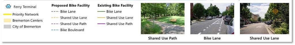
14 Sectin 1: Cnditins and Trends Existing Bicycle Facilities Bicycle facilities are an imprtant element in the transprtatin netwrk. Currently, bicycle facilities are limited t shared lane use markings and bicycle lanes n Kitsap Way, Wheatn Way, Charlestn Bulevard, and Aut Center Way, as well as shared use paths and trails within city parks. Existing gaps in the bicycle netwrk create high stress envirnments in which bicyclists must navigate thrugh vehicle traffic r difficult arterial crssings t cmplete their jurney. Figure 5: Examples f Existing Bicycle Facilities Figure 5 shws examples f Bremertn s bicycle facilities including newly cnstructed bike lanes n Lwer Wheatn Way (tp) and share the rad signage n Tracytn Beach Rad (bttm). Bremertn is actively wrking t imprve cnditins fr bicyclists. The City recently cmpleted several bicycle prjects including the installatin f sharrws n Kitsap Way between Callw Avenue and SR 3, bicycle lanes n Wheatn Way between the Manette Bridge and Leb Bulevard, traffic calming enhancements alng Washingtn Avenue, and bicycle lanes n Pacific Avenue between 5 th Street and the Manette Bridge. The cmmunity has identified a need fr an intercnnected bicycle netwrk with welldefined east west and nrth suth bicycle rutes as a majr pririty. Withut adequate bicycle facilities, residents and cmmuters face challenges navigating the City s street netwrk. Figure 6 shws existing bicycle and pedestrian facilities within Bremertn. T Appendix 14
15 Figure 6: Existing Bicycle and Pedestrian Facilities 15 T Appendix 15


16 Sectin 1: Cnditins and Trends Kayaking Waterfrnt cmmunities, such as Bremertn, have a unique pprtunity t prvide a variety f water based transprtatin ptins. Althugh predminantly used fr recreatin, water trails are a viable transprtatin ptin t cmmute t wrk and ther key destinatins. Figure 7: Kitsap Peninsula Water Trails Map The Kitsap Peninsula has mre than 300 miles f shreline, making it the secnd lngest castline in Washingtn State. The peninsula is spanned by the Kitsap Peninsula Water Trail, as well as the Natinal Water Trails System and the Washingtn Water Trails Cascadia Marine Trail, which reaches frm Olympia t the Canadian Brder. The peninsula cnnects t many kayak launch pints, and has the ptential t link t pedestrian and land based transit systems thrughut Bremertn and surrunding areas. Figure 7 shws a map f existing water trails in the Kitsap Peninsula. T Appendix 16


17 Sectin 1: Cnditins and Trends Public Transit Public transit serves as a key cmpnent f the transprtatin netwrk that cnnects residents with emplyment centers, public places and reginal destinatins. Many Bremertn residents and emplyees use public transit fr trips within and utside f the City. Public transit in Bremertn cnsists f fixed rute bus and ferry service prvided by Kitsap Transit, Masn Transit, and Washingtn State Ferries. Figure 8 n the fllwing page highlights the rute cverage f fixed rute bus and ferry service in Bremertn. Kitsap Transit prvides lcal, limited, and shuttle bus transit service. The majrity f transit riders access Kitsap Transit service by walking t transit frm their hme r by driving t a parking lt r n street parking and then walking t cnnect t transit. Furteen bus rutes serve Bremertn with frequencies ranging frm 20 t 60 minutes. The Bremertn Center prvides access t seven f the lcal bus rutes. Additinally, Masn Transit perates ne bus rute frm the Bremertn Center t the City f Belfair. Currently, n Kitsap Transit rutes serve PSIC Bremertn. Kitsap Transit, Masn Transit, and the Washingtn State Ferries serve the Bremertn Ferry Terminal. Kitsap Transit prvides passenger ferry service t Prt Orchard and Annaplis, every half hur, six days a week. In 2013, ft ferry ridership accunted fr 450,732 f Kitsap Transit s ttal bardings 4. The Washingtn State Ferries prvides passenger and vehicular ferry service t Bremertn via the Bremertn Seattle ferry, between 5 am t midnight. There are 15 daily ferries t Bremertn, departing every 60 t 120 minutes. Between 2013 and 2014, ridership between Bremertn and Seattle grew by apprximately 10 percent, serving ver 2.5 millin passengers. 4 uplads/pdf/bard/annualreprt2013.pdf T Appendix 17
18 Figure 8: Existing Transit Service City f Bremertn Cmprehensive PT Appendix 18 T Appendix 18
19 Sectin 1: Cnditins and Trends Active Analysis Active transprtatin is any human pwered mde f transprtatin, such as walking and biking. Figure 9 displays areas that are attractive fr active transprtatin in Bremertn. A descriptin f the active transprtatin analysis prcess is prvided belw. Tl. T frecast areas that have higher levels f active transprtatin, several indices f walking and bicycling demand were evaluated. Each index was chsen based n its relatinship between the built envirnment and travel patterns. A cmpsite scre was then calculated t determine the relative attractiveness f ne area ver anther fr active transprtatin. Estimating Active. T estimate walking and biking demand in Bremertn, eight indices were evaluated: Prximity t attractins Prximity t schls Prximity t parks Prximity t transit Ppulatin density Emplyment density Diversity f land use Age (8 80) Each index was weighted based n the strength f its relatinship with walking and biking, and measured at the census blck level using spatial analysis sftware. Each census blck was then assigned a cmpsite scre based n hw accessible r attractive it was fr walking and biking. Analyzing the Results. Bremertn s walking and bicycling results indicate that many streets near Dwntwn Bremertn are especially attractive fr walking and biking uses. Vital streets that serve as a link t a variety f uses and destinatins scred highly, including Burwell Street, 6th Street, and Warren Avenue. This plan uses these findings as a resurce t evaluate bicycle and pedestrian imprvements alng desire crridrs. T Appendix 19
20 Figure 9: Active City f Bremertn Cmprehensive PT Appendix 20 T Appendix 20


21 Sectin 1: Cnditins and Trends Freight and Aviatin Freight mvement in Bremertn ccurs primarily via the State Rutes (SR) that serve the City. SR 3, SR 304, and SR 310 are identified as WSDOT Highways f Statewide Significance. SR 3 is a grade separated freeway that travels thrugh West Bremertn and is classified by WSDOT as a T 1 Freight Crridr. SR 304, classified as a T 3 Freight Crridr, cnnects Bremertn with the Bremertn Ferry Terminal t the east and SR 3 t the west, prviding access t PSIC Bremertn and ther industrial uses suth f Bremertn. SR 310, anther T 3 crridr, is a principal arterial that serves as an east west distributr f freight traffic within the City. In additin, bth SR 303 and Natinal Ave serve as nrth suth city designated truck rutes. The WSDOT freight crridrs that serve Bremertn alng with additinal truck rutes designated by the City are shwn in Figure 10. In additin t highways and city truck rutes, railrads and air facilities are key elements in freight distributin. The Bremertn Natinal Airprt handles a variety f imprts and exprts. Because PSIC Bremertn is a Free Trade Zne, cmpanies have the ptin f aviding certain duties and fees if they imprt parts int Washingtn and d their final assembly there. The Bremertn Natinal Airprt, in cnjunctin with the freight railrad crridr that parallels the west side f SR 3, prvides the pprtunity t serve these industrial uses and prmte the mvement f materials and finished gds. Cnsistent with FAA and WSDOT guidance, the PSIC Subarea Plan utlines plicies that ensure future land uses and develpment are cmpatible with Bremertn Natinal Airprt and the industrial character f the PSIC Bremertn. Surce: Ggle, 2015 T Appendix 21
22 Figure 10: Existing WSDOT and City Truck Rutes City f Bremertn Cmprehensive PT Appendix 22 T Appendix 22

23 Sectin 1: Cnditins and Trends Mtr Vehicles With many Bremertn residents chsing mtr vehicles as their primary mde f transprtatin, the City s street and radway netwrk is critical t the transprtatin system. Increased grwth within the regin has led t mre traffic cngestin alng the State Rutes and Bremertn s main crridrs. An analysis f intersectins within the city limits was perfrmed t assess existing traffic peratins and the need fr future radway imprvements. Given the extensive nature f previus studies, such as the PSIC Bremertn Subarea Plan 5 and the SR 3/SR 304 Bremertn Interchange Imprvements Study, which invlved detailed LOS analysis and identified a range f prjects needed t supprt Bremertn s transprtatin system, 14 intersectins were selected due t their lcatin n critical crridrs within the City. Prjects identified in previus studies are included in the final 20 year prject list n page 44. Figure 11 n the fllwing page summarizes the intersectin LOS analysis. Detailed reprts f LOS are available in the Technical Analysis. Table 2: Level f Service Definitins LOS A B C DESCRIPTION Free flwing cnditins. Stable perating cnditins. Stable perating cnditins, but individual mtrists are affected by the interactin with ther mtrists. Fr this analysis, intersectins were assigned a level f service (LOS) grade based n their peratins in terms f vehicle delay. Table 2 describes the Level f Service definitins laid ut in Chapter 16 f the Highway Capacity Manual (HCM) ( Research Bard, 2010), which is the methdlgy used fr mst f the intersectins within the study. In a few lcatins, HCM 2000 was used due t limitatins in applying the HCM 2010 methdlgy. D E F High density f mtrists, but stable flw. Near capacity peratins, with significant delay and lw speeds. Over capacity, with delays. 5 Frmerly knwn as the SKIA Subarea Plan T Appendix 23
24 Figure 11: Aut Level f Service City f Bremertn Cmprehensive PT Appendix 24 T Appendix 24
25 Sectin 1: Cnditins and Trends The City s level f service (LOS) plicy aims t develp a transprtatin system that achieves a level f service (LOS) that balances multimdal needs and mbility. The City will maintain a LOS E r better (V/C less than r equal t 1.0) thrughut the City; except alng SR 310, which is a Highway f Statewide Significance (HSS) rute. All intersectins analyzed meet the City s current level f service (LOS) standards. Hwever, the fllwing intersectins are clse t exceeding the acceptable maximum vehicle delay f the standards: Warren Avenue (SR 303) and 6th Street (LOS D appraching LOS E) Warren Avenue (SR 303) and 11th Street (LOS D appraching LOS E) These intersectins are lcated alng key eastwest and nrth suth crridrs. SR 303 is a three t fur lane principal arterial rad, which extends frm Burwell Street (SR 304) in Bremertn t Waaga Way (SR 3/SR 303) at its nrthern terminus in Silverdale. Opprtunities and Challenges The City f Bremertn has several imprtant challenges t face as it prepares fr future grwth and the develpment f its dwntwn cre, city centers, and PSIC Bremertn. Mtr vehicle travel dminates the City s transprtatin framewrk and cntributes t cngestin in Bremertn, especially during peak cmmute hurs. Bremertn is wrking t create a mre vibrant cmmunity that prmtes an integrated multimdal transprtatin system, which will be key t addressing the transprtatin challenges within the city. Netwrk Cnnectivity The Bremertn Center and Ferry Terminal serve as a majr transprtatin hub fr Kitsap Cunty. With clse access t Seattle, many reginal cmmuters travel thrugh Bremertn t access the ferry. Bremertn is als hme t the largest emplyer in Kitsap Cunty, Naval Base Kitsap (NBK Bremertn). NBK Bremertn places significant demands n SR 304 and surrunding radways, especially during afternn shift changes. Due t Dwntwn Bremertn s status as majr center fr cmmuters, the lcal transprtatin netwrk experiences significant traffic surges in driving, walking, biking, and transit during peak hurs. Pedestrian and Bicycle Infrastructure Bremertn dwntwn has a relatively cmplete netwrk f sidewalks, hwever high pedestrian activity areas such as schls and shpping areas have gaps in the sidewalk and pedestrian facilities. This limits mbility and accessibility f sme pedestrians between majr destinatins. Additinally, the city has a bicycle netwrk that is limited t a small number f shared use trails, n street facilities, and disjinted marked bicycle rutes. These gaps in infrastructure, alng with a tpgraphy that includes many hills, create travel challenges fr pedestrians and bicyclists. Transit Access and Availability Kitsap Transit prvides lcal, limited, and shuttle bus transit service n infrequent service schedules. This limits transit dependent riders accessibility, and it causes ptential transit users t chse driving persnal vehicles. In additin t fixed rute and shuttle services, T Appendix 25
26 Sectin 1: Cnditins and Trends Kitsap Transit ffers a wrker/driver bus prgram, which functins similarly t a large carpl. This prgram has seen success in reducing the number f drive alne cmmute trips within Bremertn at NBK Bremertn. The City shuld cntinue t lk fr ways t encurage enhanced transit service frm Kitsap Transit thrugh investments in prjects that cmpliment transprtatin demand management prgrams such as the wrker/driver bus, as well as transit supprtive amenities t help residents, emplyees, and visitr s access and use transit. Puget Sund Industrial Center (PSIC) Accrding t the PSIC Subarea Plan (frmerly knwn as the SKIA Subarea Plan), 12 miles f trails are planned within the develpment area. It is anticipated that new radways wuld have sidewalks n at least ne side f the crridr. At this time, there are n ther planned r funded transit, pedestrian, r bicycle imprvements anticipated within PSIC Bremertn. As PSIC Bremertn develps as an attractive jb center and emplyment grws, it is pssible Masn Transit r Kitsap Transit will prvide bus service. Ferry Service Access and Availability Bth Kitsap Transit and Washingtn State Ferries serve the Bremertn Ferry Terminal. Ferry service in Bremertn serves thusands f weekly cmmuters. During peak hurs, the Ferry Terminal experiences significant surges in vehicle, walking, and bicycling traffic. Imprving bicycle and pedestrian cnnectins t the Ferry Terminal can help t further alleviate cngestin in the dwntwn area. Reginal Grwth Reginal develpment utside f Bremertn will play a majr rle in the grwing demands n the City s transprtatin netwrk by Kitsap Cunty is expected t cntinue adding residents and jbs during this time perid. This grwth will add traffic t Bremertn s streets, and the City must make a cncerted effrt t accmmdate its wn grwth, while crdinating with its partners utside the city n reginal needs. T Appendix 26
27 Sectin 1: Cnditins and Trends Safe Rutes fr All, Especially Pedestrians and Bicycles Since 2010, Bremertn has experienced nearly 700 traffic cllisins per year. Figure 12 display traffic crashes arund the City ver a five year perid spanning Figure 13 shws the severity f accidents by lcatin. Figure 14 displays bicycle and pedestrian crashes. As an effrt t increase pedestrian safety, Bremertn has undertaken sidewalk and crsswalk imprvement prjects t create a better envirnment fr pedestrians mving arund dwntwn, rutes t schls, and key crridrs. Crridrs with a high number f cllisins invlving pedestrians and bicyclists include Warren Avenue, Burwell Street, and 6th Street. There were fur vehicle related fatalities; tw n SR 3, ne n Wheatn Way, and ne n Schley Blvd; and ne pedestrian fatality n SR 30. T Appendix 27
28 Figure 12: Cllisins Disclaimer: Under 23 U.S. Cde 409, safety data, reprts, surveys, schedules, lists cmplied r cllected fr the purpse f identifying, evaluating r planning the safety enhancement f ptential crash sites, hazardus radway cnditins, r railway highway crssings are nt subject t discvery r admitted int evidence in a Federal r State curt prceeding r cnsidered fr ther City purpses f Bremertn in any actin Cmprehensive fr damages arising PT Appendix 28 frm any ccurrence at a lcatin mentined r addressed in such reprts, surveys, schedules, lists r data. T Appendix 28
29 Figure 13: Severity f Accidents Disclaimer: Under 23 U.S. Cde 409, safety data, reprts, surveys, schedules, lists cmplied r cllected fr the purpse f identifying, evaluating r planning the safety enhancement f ptential crash sites, hazardus radway cnditins, r railway highway crssings are nt subject t discvery r admitted int evidence in a Federal r State curt prceeding r cnsidered fr ther City purpses f Bremertn in any actin Cmprehensive fr damages arising PT Appendix 29 frm any ccurrence at a lcatin mentined r addressed in such reprts, surveys, schedules, lists r data. T Appendix 29
30 Figure 14: Bicycle and Pedestrian Cllisins Disclaimer: Under 23 U.S. Cde 409, safety data, reprts, surveys, schedules, lists cmplied r cllected fr the purpse f identifying, evaluating r planning the safety enhancement f ptential crash sites, hazardus radway cnditins, r railway highway crssings are nt subject t discvery r admitted int evidence in a Federal r State curt prceeding r cnsidered fr ther City purpses f Bremertn in any actin Cmprehensive fr damages arising PT Appendix 30 frm any ccurrence at a lcatin mentined r addressed in such reprts, surveys, schedules, lists r data. T Appendix 30
31 Sectin 1: Cnditins and Trends Dwntwn Circulatin Bremertn s dwntwn circulatin pattern is a mixed netwrk f ne way and tw way streets that face unique gegraphic and traffic demands. The dwntwn cre is the primary area f cngestin fr Bremertn. Much f the cmmunity recgnizes that Bremertn s cngestin is greatest between 4:00 pm and 4:45 pm. During this time, many wrkers are released frm wrk, including apprximately 20,000 civilians and active duty persnnel wh wrk fr Navy Cmmands lcated n NBK Bremertn. This is apprximately 5,000 peple less than the 2014 Seattle Mariners average attendance. This results in a rush f vehicles departing frm dwntwn parking garages, bus trips departing frm the Bremertn Center, and ferry trips arriving/departing t Seattle, Prt Orchard and Annaplis. As a result, daily vehicle traffic backs up quickly n Burwell Street, 6th Street, 11th Street and Warren Avenue. Between fixed rute buses and ferries cnnecting at the Bremertn Center, t the release f majr emplyment centers during peak hurs, Dwntwn Bremertn experiences significant multimdal traffic cngestin. Adding t the cngestin is limited east west and nrth suth arterials that create chkepints, such as the Warren Avenue and Manette Bridge. Sme key elements t be recgnized fr dwntwn circulatin include the fllwing. Naval Base Kitsap Puget Sund Naval Shipyard and IMF and many ther Navy Cmmands are lcated nbard NBK Bremertn in the urban cre f Bremertn. Due t its lcatin and psitin as a majr reginal emplyment center, Navy Emplyers n NBK Bremertn cntribute t a significant amunt f traffic cngestin. During shift changes, traffic increases n the radways surrunding the base, with the greatest number f vehicles exiting the base n weekdays arund 4:00 pm. There is a variety f transit incentives being utilized by emplyers lcated n NBK Bremertn in crdinatin with Kitsap Transit and the Washingtn State Ferries t prvide alternatives t driving t wrk. The Cmmands lcated n NBK Bremertn expect t see increased emplyment in the future, which will further stress the transprtatin system surrunding the base as well as dwntwn parking availability, as many f the emplyees wh wrk n the base currently use city wned parking garages and surface lts. Dwntwn Parking Demand Bremertn s dwntwn n street parking supply is currently available n a first cme, first serve basis, with time restrictins in sme lcatins. City wned parking areas include Harbrside Garage, Washingtn Garage, Park Plaza Garage, City Lt 95, and City Lt 98. Anticipated grwth and develpment in the central cre may necessitate mre active parking management in the future as demand fr parking increases. T Appendix 31


32 Sectin 1: Cnditins and Trends Peak Hur Transit Ridership During mrning and afternn peak hurs, the Bremertn Center and Ferry Terminal experience high numbers f passengers. The ferry service alne experiences ver 10,000 bardings weekly n Kitsap Transit ft ferries t Annaplis and Prt Orchard, and ver 28,000 weekly bardings between Bremertn and Seattle. T Appendix 32
33 Sectin 2: Cmmunity Outreach Cmmunity Outreach Cmmunity input regarding the future f transprtatin in Bremertn was cllected at a public meeting and stakehlder wrkshp. Cmmunity members and stakehlder grups were asked t answer questins regarding the future f Bremertn s transprtatin in regards t priritizing prjects and funding, as well as identifying pririty netwrk rutes and prjects fr all mdes. Participants shwed a desire fr multimdal investments, imprved netwrk cnnectivity, and enhanced safety in Bremertn. Stakehlder Meeting On July 28th, 2015 a stakehlder wrkshp was cnducted with the City f Bremertn and key stakehlders. The purpse f the meeting was t examine the transprtatin needs f Bremertn and identify bth transprtatin challenges and pprtunities fr imprvement. Stakehlder feedback, in regards t the mst needed and visinary prjects fr Bremertn, can be seen in Table 3. Table 3: Stakehlder Input WHAT IS THE MOST NEEDED PROJECT IN BREMERTON? Multimdal cnnectins t Bremertn Centers Updated facilities fr all users Radway maintenance Parking management Ferry cnnectins ADA facilities and imprvements Traffic cngestin relief n SR 3/304 interchange East west bicycle rutes WHAT IS THE MOST VISIONARY PROJECT FOR BREMERTON? Have the chice t mve safely thrugh Bremertn by all mdes Create an intercnnected multimdal transprtatin system Create a seawater path system Imprve parking management and repurpse underutilized lts Increase land use diversity in dwntwn Imprve Kitsap Transit cnnectins t Olympic Cllege Be the transprtatin hub f Kitsap Cunty Adapt t new transprtatin technlgies T Appendix 33
34 Sectin 2: Cmmunity Outreach Public Meeting Nearly 200 cmments were received at the public meeting. Cmmunity members prvided input n what impacts hw peple travel in Bremertn tday and what transprtatin prjects shuld be the highest pririty fr funding. Respndents shwed a desire fr multimdal investments t reduce cngestin, enhance safety and imprve netwrk cnnectivity. It is imprtant t nte that the cmments cllected likely underrepresent reginal cmmuters, as the majrity f respndents were lcal residents. In additin, the meeting was heavily attended the bicycle cmmunity, which may have ver represented Bremertn residents bicycle interests and pririties. Apprximately 60 percent f the issues affecting residents travel tday invlved safety (23%) and the lack f pedestrian (22%) and bicycle (15%) facilities, as seen in Figure 15. Figure 16 utlines which prjects were identified as the highest pririty fr funding the tp tier prjects included: Build mre sidewalks and crsswalks, imprve existing crsswalks Make rutes fr bikes n quiet streets (greenways) Prvide bike lanes n arterial streets Replace and repair lder infrastructure Figure 15: Greatest Impacts t Travel Safety 4% 11% 15% 4% Other 1% Parking 15% Ferry service 14% Traffic cngestin Lack f sidewalks 23% 2% Lack f bicycle facilities 22% Radway maintenance Inadequate Bus Service High speed and traffic in neighbrhds Figure 16: Pririties fr Funding T Appendix 34

35 Sectin 3: Future Visin Bremertn envisins a future transprtatin system that serves all users and mdes f travel by ffering a safe and rbust netwrk f walkways, bicycle facilities, intersectins, and radways. This sectin describes Bremertn s visin fr its future transprtatin netwrk and the infrastructure imprvements that will get the City there. As a part f the Cmprehensive Plan update, the City is planning fr expected grwth in husing units and emplyment ver the next 20 years thrugh Based n grwth estimates frm the Puget Sund Reginal Cuncil (PSRC) and review by City staff, Bremertn is preparing fr 8,050 new husing units and 20,244 new wrkers by 2036 within the city limits and urban grwth area. This translates int a ppulatin grwth f apprximately 1.5 percent annually. nt desirable frm a user r a planning perspective. In respnse t this challenge, the City f Bremertn has adpted a layered netwrk apprach that fcuses n hw the City s transprtatin netwrk can functin as a system t meet the needs f all users. In such a system, individual travel mdes are priritized n different facilities thrughut the verall netwrk. Figure 17 illustrates the cncept f a layered netwrk. The City will implement this layered netwrk thrugh a system f radway typlgies that define each street s user pririties and assciated infrastructure needs. Figure 17: Layered Netwrk Cncept As identified in this plan, mst f the imprvements are fcused n the develpment f a layered transprtatin netwrk, which fcuses less n prviding vehicular capacity and mre n accmmdating all mdes f travel. While sme f the radway imprvements are needed t meet the City s vehicular level f service (LOS) standard, many f the future imprvements fcus n prviding safer and mre cmplete facilities fr walking, bicycling, and riding transit in rder t imprve access and mbility fr all rad users. Intrductin t the Layered Netwrk It can be a challenge fr a single radway t meet the demands and expectatins f all mdes at any given time. This is als generally T Appendix 35
36 Sectin 3: Future Visin Mdal Netwrks Streets in Bremertn serve different travel purpses, and the mdal netwrks therefre priritize a different balance f users n each crridr. Determining hw the entire transprtatin netwrk fits tgether in Bremertn requires identifying desirable streets fr each mde, cmbining them t lcate verlaps, and then assigning pririty t certain mdes. The fllwing sectins review the pririty netwrks fr each mde and establish their level f service standards. Pedestrian While Bremertn s lcal streets tend nt t need fully separate sidewalks r paths due t their lw traffic vlumes and slw speeds, the City s arterials and cmmercial cllectrs d warrant pedestrian infrastructure. Dense areas with cmmercial land uses and streets that serve schls, parks, and churches are particularly imprtant fr safe walking, as they supprt mre pedestrians and may have a larger prtin f vulnerable users than ther streets. The highest level f accmmdatin fr walking, indicated in the green rw, wuld prvide sidewalks n bth sides f the rad as shwn in the Pedestrian Pririty Netwrk. The yellw level f accmmdatin wuld make strng prgress in building ut the Pedestrian Pririty Netwrk by filling sidewalks gaps arund the City in lcatins nearby pedestrian generatrs, such as retail, schls and parks. Incmplete r missing pedestrian facilities wuld fall int the red categry and nt satisfy the City s gals fr accmmdating pedestrians. Table 4: Pedestrian Accmmdatin Sidewalk Prvisin WITHIN PEDESTRIAN PRIORITY NETWORK Sidewalk prvided n bth sides f the rad* Sidewalk r wide shulder prvided n ne side f the rad N pedestrian facility prvided Figure 18 highlights the Pedestrian Pririty Netwrk, which specifies where pedestrian infrastructure shuld be prvided in the lng term. Building n the Pedestrian Pririty Netwrk, Table 4 establishes guidance in terms f the level f accmmdatin that the City wishes t prvide fr pedestrians arund the City. T Appendix 36
37 Sectin 3: Future Visin Bicycling Bremertn s existing bicycle netwrk cnsists f bike lanes, shared use markings and a number f trails and shared use pathways. Bicyclists face many challenges cnnecting t existing facilities and traveling crsstwn due t limited bicycle facilities, pr pavement cnditins, and feelings f unease n the majrity f the cnnecting rads. Key mbility crridrs fr bicyclists, such as Naval Avenue and Leb Bulevard wuld be best served with n street bike lanes, while bike bulevards and shared use paths wuld suffice n streets such as 4th and 5th Avenues. Table 5: Bicycle Accmmdatin Facility Descriptins WITHIN BICYCLE PRIORITY NETWORK Prvides minimum treatment* recmmendatin, as shwn within the Bicycle Pririty Netwrk Prvides a lwer level facility than recmmend in the Bicycle Pririty Netwrk N bicycle facility r signage Figure 19 highlights the Bicycle Pririty Netwrk, which specifies where pedestrian infrastructure shuld be prvided in the lng term. The City f Bremertn can strive fr the green level f accmmdatin fr bicycling by installing the bicycle facilities depicted in the Bicycle Pririty Netwrk r a facility that ffers greater separatin frm vehicle traffic. At a minimum, the City shuld make meaningful prgress tward cnstructing this netwrk by building sme initial nrth suth and east west spines. Incmplete r missing bicycle facilities d nt meet the City s desired level f accmmdatin fr bicycling, as described in Table 5. T Appendix 37
38 Figure 18: Pedestrian Pririty Netwrk City f Bremertn Cmprehensive PT Appendix 38 T Appendix 38
39 Figure 19: Bicycle Pririty Netwrk City f Bremertn Cmprehensive PT Appendix 39 T Appendix 39
40 Sectin 3: Future Visin Transit Transit peratins are ut f the City s direct cntrl, but Bremertn can still aim t create crridrs that are welcming t transit. The City will cntinue t wrk with transit agencies t enhance transit use by ffering street lighting, safe rutes fr accessing transit stps, and ther passenger amenities. Bremertn s level f transit accmmdatin is based n the amenity prvisin guidelines established by transit agencies serving Bremertn. The City can reach the highest level f accmmdatin (green) by prviding the level f transit supprtive amenities recmmended including sidewalks, and marked crsswalks at all stps, as well as ther supprtive amenities, t supprt mre frequent service. Bremertn s measurement f transit accmmdatin is summarized in Table 6. REGIONAL TRANSIT COORDINATION One f the City s tp pririty in this plan is effective crdinatin with reginal players t ensure that the lcal and reginal transprtatin systems cmplement ne anther. A key element f this will be partnering with Kitsap Transit, Masn Transit, and Washingtn State Ferries t prvide lcal transit alternatives fr getting acrss twn. The ptential increase in Kitsap Transit service ffers a majr pprtunity t explre hw the transit statin can be better integrated with the City s multimdal transprtatin system and increase demand fr lcal transit services. Table 6: Transit Accmmdatin Stp Amenities and Pedestrian Access TRANSIT STOP AMENITIES Mre than 80% f transit stps meet amenity minimum prvisins Mre than 60% f transit stps meet amenity minimum prvisins Less than 60% f transit stps meet amenity minimum prvisins T Appendix 40
41 Sectin 3: Future Visin Freight and Aut Residents and wrkers in Bremertn use nearly every street in the radway netwrk at sme pint each day t access their hmes, jbs, and ther destinatins. Many f these streets are lcal streets, hwever, and d nt see significant traffic vlumes thrughut the day. Similarly, gds mvement and delivery vehicles use sme crridrs frequently while ther streets see nly the ccasinal lcal delivery. Figure 3 (page 12) calls ut the functinal classificatin f each f Bremertn s streets, in terms f whether it is an arterial, cllectr, r lcal street. These classes indicate the level f pririty f each street fr autmbiles, specifically in terms f facilitating vehicle and freight mbility as well as ther mdes. Bremertn s transprtatin netwrk is cnstantly evlving alng with the character f its radways. As part f this update, changes t Bremertn s functinal classificatin are being cnsidered fr radways such as Sherman Heights Rad, Charlestn Beach Rad, Cherry Avenue, and thers. The functinal classificatin and freight class f a street shuld guide future investments in streetscape and LOS bjectives. Given the lw grwth rates fr husehld and emplyment prjected fr Bremertn, future frecast delay at intersectins differ little than frm tday. Of the 14 intersectins analyzed as part f this update, all intersectins (existing and future) meet the City s LOS standards. Als, the grwth anticipated n state wned facilities is driven by reginal grwth, as well as grwth anticipated within the City. T address this, the City s netwrk has capacity t absrb sme grwth. Delays n parts f the City s netwrk are a result f backups n the reginal netwrk, rather than lcal level capacity cnstraints. The Technical Analysis f this Appendix summarizes existing and future frecast delay at intersectins in the City. The capital list prvided in next sectin includes future radway prjects that wuld maintain the City s intersectin LOS standard thrugh Figure 10 (page 22) specifies the WSDOT freight classificatin f Bremertn s majr streets that supprt gds mvement. These classificatins indicate the annual weight f gds that travel a crridr, whether via large trailer lads r smaller delivery vehicles. T Appendix 41
42 Sectin 3: Future Visin Mde split targets Fr its reginal grwth centers (RGCs), the City f Bremertn is required t develp mde split targets that align with the plicy gals f planning these areas t be mre cmpact and accessible fr walking, biking, and transit mdes. The fllwing table prvides existing and envisined future mde split targets fr cmmute trips within Bremertn s Dwntwn Reginal Grwth Center and the Puget Sund Industrial Center (PSIC), which is a Reginal Manufacturing/Industrial Center. These increased nn SOV mde shares reflect the City s gal f accmmdating travel by all mdes and priritizing transprtatin investments within the reginal grwth centers (RGCs). These mde share gals als infrmed the travel mdeling perfrmed fr this plan t ensure that transprtatin infrastructure investments align with frecasted travel demand. The 2010 mde share estimates cme frm Puget Sund Reginal Cuncil s (PSRC s) reginal travel survey. The future mde share estimates fr each center were develped based n natinal travel survey, which shw hw nn SOV mde share can increase when a greater mix f uses, imprved infrastructure fr walking and biking, and prximate transit are prvided. Table 7: Mde Split Targets fr Reginal Grwth Centers in Bremertn MODE DOWNTOWN BREMERTON PUGET SOUND INDUSTRIAL CENTER Drive Alne 69% 66% 89% 85% Carpl 9% 10% 9% 11% Transit 13% 14% 1% 2% Walk/Bike 9% 10% 1% 2% T Appendix 42
43 Sectin 4: Prjects This sectin presents the capital and radway maintenance prjects that frms the basis f this Plan. The verall capital plans were develped t create a transprtatin system that realizes Bremertn s ultimate transprtatin visin: t prmte, manage, and maintain a safe, efficient, and integrated multi mdal transprtatin system t supprt a healthy and vibrant cmmunity. T1: Prmte and develp transprtatin systems that stimulate, supprt, and enhance the mvement f peple and gds t ensure a prsperus ecnmy. T2: Acknwledge the existing built envirnment and maintain, preserve, and extend the life and utility f prir investments in transprtatin systems and services. T3: Prvide fr and imprve the safety and security f transprtatin users and the transprtatin system. T4: Enhance Bremertn's quality f life thrugh transprtatin investments that prmte energy cnservatin, healthy cmmunities, aesthetics, and prtect the envirnment. T5: Cntinuusly imprve the quality, effectiveness, and efficiency f the transprtatin system. With these gals in mind, as well as cmpleting the layered netwrks described in the previus sectins, the prject list was develped. Table 8 summarizes the recmmended capital prjects fr the City and PSIC Bremertn 6, as well as peratin and maintenance needs fr the next twenty years. These prjects represent a balance f safety, maintenance, and peratinal imprvements fr all mdes. Figure 22 t 24 display the lcatins f these prjects arund the City. 6 Summarizes the prjects that were identified fr PSIC Bremertn thrugh the PSIC Subarea Plan T Appendix 43
44 Table 8: Twenty Year Prject List 8.1 Twenty Year Capital Prjects Prject # Prject Title Benefit t Bremertn Ttal Cst Gal Met 1 SR3 Crridr Planning/Envirnmental Reduce traffic cngestin and imprve accessibility $15,000 T1, T3, T5 2 Highway Safety Imprvements Prject Phase 2 Imprve safety and accessibility $951,000 T1, T2, T3, T5 3 Crsswalk Prject Bundle Imprve pedestrian safety and cnnectivity $670,000 T1, T3, T4, T5 4 ADA Transitin Plan Imprve pedestrian safety and cnnectivity $200,000 T1, T3, T4, T5 5 Nn mtrized Plan Update Imprve bicycle and pedestrian travel in Bremertn $50,000 T1, T3, T4, T5 6 Traffic Calming Imprve safety fr all mdes $160,000 T1, T3, T4, T5 7 Sidewalk Imprvements (Sidewalk Abatement Fund) Imprve pedestrian safety and cnnectivity $1,780,000 T1, T3, T4, T5 8 City Safety Imprvement Annual Prgram Imprve safety citywide $500,000 T3, T5 9 Signal System Upgrades Upgrade signals t help mve traffic and imprve level f service $1,025,000 T1, T2, T3, T5 10 Leb Blvd, Wheatn Way t City Limits Nnmtrized Imprvements Imprve bicycle and pedestrian safety and cnnectivity $3,350,000 T1, T3, T4, T5 11 Crwnhill Elementary Safe Rutes t Schls Imprve bicycle and pedestrian safety near schls $485,000 T1, T3, T4, T5 12 Kitsap Lake Elementary Safe Rutes t Schls Imprve bicycle and pedestrian safety near schls $1,320,000 T1, T3, T4, T5 13 View Ridge Safe Rutes t Schls Imprve bicycle and pedestrian safety near schls $900,000 T1, T3, T4, T5 14 Naval Avenue Safe Rutes t Schls Imprve bicycle and pedestrian safety near schls $660,000 T1, T3, T4, T5 15 Crwnhill Elementary Safe Rutes t Schls Imprve bicycle and pedestrian safety near schls $770,000 T1, T3, T4, T5 City f Bremertn Cmprehensive PT Appendix 44 T Appendix 44
45 16 Armin Jahr Elementary Safe Rutes t Schls Imprve bicycle and pedestrian safety near schls $660,000 T1, T3, T4, T5 17 Natinal/Arsenal Safe Rutes t Schl fr STEM Academy (Jint w/ Cunty) Imprve bicycle and pedestrian safety near schls $1,100,000 T1, T3, T4, T5 18 Andersn Cve Sidewalks; 19th & Naval t 15th Imprve pedestrian safety and cnnectivity $440,000 T1, T3, T4, T5 19 Matan & Lillian & James Walker Park Sidewalk Cnnectr; Blmingtn & Olympic 20 Street Lights at Warren Avenue at 4th and 5th Street Crsswalks Imprve pedestrian safety and cnnectivity $440,000 T1, T3, T4, T5 Imprve safety fr pedestrians at crssings $30,000 T1, T3, T4, T5 21 Install yellw flashing lights n left turns city wide Help mve traffic and imprve intersectin level f service $75,000 T1, T3, T5 22 Washingtn Avenue, Warren t Manette Bridge Imprve bicycle and pedestrian safety and cnnectivity $2,750,000 T1, T3, T4, T5 23 East Bremertn Shared Use Path (WSCC Initiative; cnnects t Cunty) Imprve bicycle and pedestrian safety and cnnectivity $680,000 T1, T3, T4, T5 24 Streets Electrical Cabinet Replacement Prgram Maintenance upgrades t streets electrical cabinets $175,000 T2, T5 25 Belfair Valley Rad Shulder Widening fr Multimdal Travel Imprve bicycle and pedestrian safety and cnnectivity $450,000 T1, T3, T4, T5 26 4th Street Landscaping Replacement / Sidewalk Repair Maintenance upgrades t sidewalk t imprve pedestrian safety and cnnectivity $400,000 T1, T2, T3, T4, T5 27 Ped Cnnectr Under Warren Avenue Bridge Suth Apprach 28 Warren Avenue Bridge Recnfiguratin fr Multi Use Imprve pedestrian safety and cnnectivity $500,000 T1, T3, T4, T5 Imprve bicycle and pedestrian safety and cnnectivity $2,500,000 T1, T3, T4, T5 29 SR303 Crridr Imprvements Burwell t Riddell Imprve mtr vehicle cnnectivity $10,250,000 T1, T2, T5 30 Wheatn Way extend left turn pcket frm 16th suth t 13th fr Cllege Main Entrance Help mve traffic and imprve level f service near Olympic Cllege $700,000 T1, T3, T5 City f Bremertn Cmprehensive PT Appendix 45 T Appendix 45
46 31 Oyster Bay Avenue Imprvements Help mve traffic and imprve radway safety $700,000 T1, T3, T4, T5 32 Marine Drive NMT Imprvements Imprve bicycle and pedestrian safety and cnnectivity $950,000 T1, T3, T4, T5 33 Cnstruct Werner Rad widening and signal imprvements Upgrade signals and radway t help mve traffic and imprve level f service $3,000,000 T1, T2, T3, T5 34 Cnstruct street lighting n Pine Rad Imprve radway safety fr all mdes $400,000 T3, T5 35 Arsenal Way/Pattn Ave Safety Imprvements Imprve bicycle and pedestrian safety and cnnectivity $100,000 T1, T3, T4, T5 36 Grst Sinclair Trail (Planning) Imprve bicycle and pedestrian safety and cnnectivity $200,000 T1, T3, T4, T5 37 Access ways in Dckside (Planning) Imprve pedestrian safety and cnnectivity $50,000 T1, T3, T4, T5 38 Naval Ave Rad Diet Imprve bicycle and pedestrian safety and cnnectivity $100,000 T1, T3, T4, T5 39 Cnstruct street lighting n Ricky Rad per 2008 develper agreement Imprve radway safety fr all mdes $200,000 T3, T5 40 Shre Drive Shared Use path (Planning) Imprve bicycle and pedestrian safety and cnnectivity $60,000 T1, T3, T4, T5 41 West Belfair Valley Rad Guardrails Evaluatin and Implementatin 42 City Street Lighting evaluatin and upgrade fr cmpliance with standards 43 Hspital District Street Imprvements; Callahan, Cherry, Wheatn 44 Replace traffic signs t meet retrreflective requirements Imprve radway safety $60,000 T3, T5 Imprve radway safety fr all mdes $50,000 T1, T3, T4, T5 Imprve radway safety fr all mdes $50,000 T1, T2 Imprve radway safety fr all mdes $200,000 T2, T5 45 Sidewalk Imprvement Wheatn Way at Callahan Imprve pedestrian safety and cnnectivity $187,504 T1, T3, T4, T5 46 Sidewalk Ramp Recnstructin Warren Avenue Wheatn Way Crridr (Jint w/ WSDOT) Imprve pedestrian safety and cnnectivity $100,000 T1, T3, T4, T5 City f Bremertn Cmprehensive PT Appendix 46 T Appendix 46
47 47 Bridge t Bridge Trail Wayfinding Imprve bicycle and pedestrian safety and cnnectivity $75,000 T1, T3, T4, T5 48 Kitsap Way Bike Lane Imprvements (See WSCC Prpsal) 49 Lwer Wheatn Way Recnstructin Leb t Sheridan 50 West Kitsap Way Recnstructin / Rechannelizatin Imprve bicycle safety and cnnectivity $200,000 T1, T3, T4, T5 Imprve bicycle and pedestrian safety and cnnectivity $2,000,000 T1, T3, T4, T5 Imprve mtr vehicle cnnectivity $3,000,000 T1, T3, T5 51 Dwntwn Street Circulatin Study Imprve traffic circulatin fr all mdes $50,000 T1, T3, T4, T5 52 Manette Traffic Circulatin Study Imprve traffic circulatin fr all mdes $25,000 T1, T3, T4, T5 53 Repair Dwntwn Street Standard Banner Supprts Maintenance imprvements $100,000 T2, T5 54 State Street Pedestrian Crridr Imprvements Imprve pedestrian safety and cnnectivity $5,000,000 T1, T3, T4, T5 55 Kitsap Lake Vicinity Ped/Bike Imprvements Imprve bicycle pedestrian safety and cnnectivity $6,000,000 T1, T3, T4, T5 56 Warren Avenue Imprvements fr Bus Rapid Transit Imprve transit service in Bremertn $1,000,000 T1, T3, T4, T5 57 Marine Drive LOS Imprvements at Kitsap Way Reduce traffic cngestin and imprve accessibility $1,500,000 T1, T5 58 Warren Avenue Intersectin LOS Imprvements, Burwell t Bridge Reduce traffic cngestin and imprve accessibility $8,000,000 T1, T5 59 N/S Crridr Bike/Ped Backbne Imprvements Imprve bicycle pedestrian safety and cnnectivity $3,000,000 T1, T3, T4, T5 60 E W Crridr Rad Diet, Pacific t Kitsap Way Imprve bicycle pedestrian safety and cnnectivity $8,000,000 T1, T3, T4, T5 City f Bremertn Cmprehensive PT Appendix 47 T Appendix 47
48 61 Green Standard Pedestrian Imprvements Imprve pedestrian facility cverage (at least n ne side f the street) t fill key gaps in nn lcal streets and near schls 62 Green Standard Bicycle Imprvements Imprve safety and cmfrt fr peple biking arund the City thrugh implementatin f initial nrth suth and east west spines, as well as bicycle bulevards 63 Yellw standard pedestrian imprvements Imprve pedestrian facility cverage (at least n ne side f the street) t fill key gaps in nn lcal streets and near schls 64 Yellw standard bicycle imprvements Imprve safety and cmfrt fr peple biking arund the City thrugh implementatin f initial nrth suth and east west spines, as well as bicycle bulevards $6,000,000 T1, T3, T4, T5 $3,000,000 T1, T3, T4, T5 $14,238,000 T1, T3, T4, T5 $1,371,117 T1, T3, T4, T5 Subttal $102,952, Twenty Year PSIC Bremertn Prjects Prject # Prject Title Benefit t Bremertn Ttal Cst Gal Met 1 Area B Cllectr Rad new radway west f SR 3 at Crss PSIC intersectins Supprt PSIC Bremertn grwth and develpment $4,441,400 T1, T5 2 Area C Cllectr Rad new radway suth f Lak Flra Rad t the Belfair Bypass 3 Area D Cllectr Rad prtin f new radway suth f Lake Flra Rad 4 Area F Cllectr Rad new radway nrth frm Lake Flra Rad 5 Area G Cllectr Rad new radway east frm Crss PSIC Rads Supprt PSIC Bremertn grwth and develpment $1,835,600 T1, T5 Supprt PSIC Bremertn grwth and develpment $498,000 T1, T5 Supprt PSIC Bremertn grwth and develpment $3,140,000 T1, T5 Supprt PSIC Bremertn grwth and develpment $415,100 T1, T5 City f Bremertn Cmprehensive PT Appendix 48 T Appendix 48
49 6 Lcal Access Prjects 5.64 miles f lcal access rad 7 SR 3 / Imperial Way signalize intersectin, mdify appraches 8 SR 3 / Sunnyslpe Rad signalize intersectin, mdify appraches 9 SR 3 / SR 16 / Sam Christphersn Ave grade separatin 10 Old Cliftn Rad / SR 16 Eastbund Ramps Signalize intersectin add dedicated right turn EB and dedicated left turn WB 11 Old Cliftn Rad / SR 16 Westbund Rampssignalize intersectin 12 Analysis Area C and SR 3 New intersectin suthwest f existing Lake Flra Rad / SR 3 intersectin 13 Analysis Area C/D and Lake Flra Rad New intersectin sutheast f existing Lake Flra Rad / SR 3 intersectin 14 Crss SKIA Cnnectr and Lake Flra Rad New intersectin at suthern terminus f extensin f Crss PSIC Cnnectr 15 Crss SKIA Cnnectr / Analysis Area B / SR 3 New intersectin at nrthern terminus f Crss SKIA Cnnectr 16 SR 3 Widening Widening frm Imperial Way t Grst Supprt PSIC Bremertn grwth and develpment $8,933,800 T1, T5 Supprt PSIC Bremertn grwth and develpment $2,000,000 T1, T5 Supprt PSIC Bremertn grwth and develpment $2,000,000 T1, T5 Supprt PSIC Bremertn grwth and develpment $63,000,000 T1, T5 Supprt PSIC Bremertn grwth and develpment $1,000,000 T1, T5 Supprt PSIC Bremertn grwth and develpment $500,000 T1, T5 Supprt PSIC Bremertn grwth and develpment $2,000,000 T1, T5 Supprt PSIC Bremertn grwth and develpment $1,000,000 T1, T5 Supprt PSIC Bremertn grwth and develpment $1,000,000 T1, T5 Supprt PSIC Bremertn grwth and develpment $500,000 T1, T5 Supprt PSIC Bremertn grwth and develpment $109,000,000 T1, T5 City f Bremertn Cmprehensive PT Appendix 49 T Appendix 49
50 17 Lake Flra Widening Widening t suthern end f ptential suthern end f Crss PSIC Bremertn rads 18 Belfair Bypass 2 lane divided highway with capability fr 4 lanes Supprt PSIC Bremertn grwth and develpment $3,201,100 T1, T5 Supprt PSIC Bremertn grwth and develpment Funded 7 T1, T5 19 Trails 12 miles f trails Supprt PSIC Bremertn grwth and develpment $1,300,000 T1, T3, T4, T5 Subttal $205,765, Operatins and Maintenance Prjects Prject # Prject Title Benefit t Bremertn Ttal Cst Gal Met 1 Austin Drive Pavement Preservatin Pavement verlay $800,000 T2, T5 2 Pavement Preservatin including Benefit District 3 Manette E. 11th Sidewalk Strm Lw Impact Develpment Retrfit 4 Annual General Maintenance and Operatins Csts 5 Annual Maintenance Prgram: Arterial and Lcal Streets Majr Maintenance and Recnstructin Pavement verlay $8,000,000 T2, T5 Maintenance upgrades t the radway $550,000 T2, T5 General peratins and maintenance $50,000,000 T2, T5 Maintenance and pavement verlays fr radway $170,000,000 T2, T5 Subttal $179,350,000 Ttal $488,067,621 7 Funded as part f 2015 Leap Prjects City f Bremertn Cmprehensive PT Appendix 50 T Appendix 50
51 Figure 20: Pedestrian Facilities City f Bremertn Cmprehensive PT Appendix 51 T Appendix 51


52 Figure 21: Bicycle Facilities City f Bremertn Cmprehensive PT Appendix 52 T Appendix 52
Federal Way City Center Access Study Comment Log Summary
 Prject verview The City f Federal Way is pursuing the City Center Access prject t find ways t imprve access t Federal Way s City Center and the surrunding area. The City is studying slutins t cngestin
CHAPTER 4 VISION, GOALS AND OBJECTIVES
 CHAPTER 4 VISION, GOALS AND OBJECTIVES Defining a visin, gals, and bjectives creates the structure fr a plan. T develp the visin fr this Plan, the team reviewed the 2012 MPO Cmprehensive Pathways Plan
PUBLIC OPEN HOUSE. Panet Road / Molson Street Reconstruction. April 24, 2013
 PUBLIC OPEN HOUSE Panet Rad / Mlsn Street Recnstructin April 24, 2013 T address issues assciated with traffic grwth arund Mlsn Street. Prject issues include: Delay at rail crssings Traffic cngestin at
Working Group Meeting #2. One Financial Plaza 1350 Main Street 3rd Floor, Community Room A Springfield, Massachusetts
 One Financial Plaza 1350 Main Street 3rd Flr, Cmmunity Rm A Springfield, Massachusetts 1 Leading the Natin in Transprtatin Excellence www.mass.gv/massdt April 9, 2015 Agenda Welcme & Intrductins Overview
Technical Memorandum. Introduction. Projected Traffic Volumes
 Technical Memrandum T: Mr. Eduard Garcia, PSW Real Estate, LLC Frm: Christy Lambeth, P.E., PTOE Lambeth Engineering Assciates, PLLC, F-19508 Date: May 29, 2018 Re: Traffic Assessment fr Prpsed Single-Family
DRAFT - TRANSPORTATION AND PUBLIC HEALTH
 DRAFT - TRANSPORTATION AND PUBLIC HEALTH Backgrund/Intrductin Transprtatin Outlk 2040, the Kansas City regin s lng-range transprtatin plan, includes a public health gal t facilitate healthy, active living.
Presented by: Presented to:
 The Challenge f Implementing Prtected Bike Lanes Delaware Avenue: A Case Study Demnstratin Presented by: Presented t: Octber 25, 2016 Presentatin Outline FAST Act Impact n Bicycle Facilities Planning Ptential
The timelines for the proposed short-term, medium-term, and long-term improvements to the corridor be accelerated.
 100 20111 93A Avenue Langley, BC V1M 4A9 e bcta@bctrucking.cm t 604 888 5319 f 604 888 2941 tll free 1 800 565 2282 bctrucking.cm 16 th Avenue Crridr Imprvements BCTA Survey Results & Recmmendatins September
EXECUTIVB SUMMARY Regular Board Action Item 98 Approval of Revised Regional Roadway Network M"p, Revised Criteria and Joint Resolution
 EXECUTIVB SUMMARY Regular Bard Actin Item 98 Apprval f Revised Reginal Radway Netwrk M"p, Revised Criteria and Jint Reslutin Objective: Fr the Bard t apprve the revised Reginal Radway Netwrk Map, Revised
COMPLETE STREETS HANDBOOK CHECKLIST Philadelphia City Planning Commission
 Philadelphia City Planning Cmmissin INSTRUCTIONS This Checklist is an implementatin tl f the Philadelphia Cmplete Streets Handbk (the Handbk ) and enables City engineers and planners t review prjects fr
Completed Project Justification Package Example
 Cmpleted Prject Justificatin Package Example Nature f the Prblem: Describe the nature f the prblem that the prject intends t mitigate r fix. Fr example, is it designed t address a current cngestin, peratinal
Phase 1: Station Area Planning. Golden Valley Road Parking Management Strategies Assessment. Purpose. Context. Parking Management Options
 Glden Valley Rad Parking Management Strategies Assessment Purpse The purpse f the Parking Management Strategy Assessment is t synthesize parking discussins during the Metr Blue Line Extensin (Bttineau
Comments Heard PUBLIC INFORMATION CENTRE #1: SUMMARY
 Images f cmmunity cmments n the Study Area maps The first Public Infrmatin Centre was held fr bth the Casablanca Bulevard and GO Access Envirnmental Assessment and the Livingstn Avenue Extensin Envirnmental
Bikeway Classification
 Bikeway Classificatin Classificatin f bikeway types is an imprtant step t help planners cmprehend hw parts f the bike netwrk functin and wrk tgether. Classificatin can als prvide an understanding f the
2.0 VISIONING DIRECTION
 NOVEMBER 2013 TABLE OF CONTENTS 1.0 INTRODUCTION...1 2.0 VISIONING DIRECTION...2 2.1 Cntext fr Sustainable Grwth The Official Cmmunity Plan...2 2.2 Transprtatin Visin...5 2.3 Integrated Gals & Objectives...6
DRAFT Active Transportation Work Plan
 DRAFT Active Transprtatin Wrk Plan T achieve the visin and gals utlined in the Plicy Framewrk SCAG will adpt the Active Transprtatin Wrk Plan which is based n plicies and gals frm the 2012 RTP/SCS. The
2017 Active Allegheny Grant Program Program Guidelines
 Redevelpment Authrity f Allegheny Cunty Nte: Fr infrmatin purpses nly. Prgram guidelines subject t change prir t next funding cycle. 2017 Active Allegheny Grant Prgram Prgram Guidelines Intrductin The
SANDYFORD BUSINESS DISTRICT SUMMARY OF AREA WIDE MOBILITY MANAGEMENT PLAN.
 SANDYFORD BUSINESS DISTRICT SUMMARY OF AREA WIDE MOBILITY MANAGEMENT PLAN www.sandyfrdsmartertravel.ie What is a Mbility Management Plan? A wrkplace Mbility Management Plan is a lng-term management strategy
Subject: Recommended Updates to Transportation Development Parameters
 T: Frm: Members f the Balba Reservir Cmmunity Advisry Cmmittee ( CAC ) Jeremy Shaw, Planning Department Date: 5/20/2016 Subject: Recmmended Updates t Transprtatin Develpment Parameters This memrandum cntains
A template mass rescue operations plan
 The Internatinal Maritime Rescue Federatin Mass Rescue Operatins Prject: A template mass rescue peratins plan Cntents This paper prvides a template fr a mass rescue peratins plan. 1 Overview 1.1 Fr a general
Project No.: Notes taken by:
 Transprtatin Land Develpment Envirnmental S e r v i c e s 101 Walnut Street Pst Office Bx 9151 Watertwn, MA 02471-9151 Telephne (617) 924-1770 Fax (617) 924-2286 Meeting Ntes Attendees: Attached Date/Time:
Advisory Group Meeting #7. March 9, Transcribed Breakout Group Discussion Notes.
 Advisry Grup Meeting #7. March 9, 2017. Transcribed Breakut Grup Discussin Ntes. Discussin Questins. What feedback have yu heard frm yur cmmunities abut the near-term strategies? What d yu think wrks abut
North Avenue Reconstruction Project Context Sensitive Solutions Advisory Group Meeting #4
 MEETING SUMMARY Nrth Avenue Recnstructin Prject Cntext Sensitive Slutins Advisry Grup Meeting #4 ATTENDEES: LOCATION: PREPARED BY: COPIES: Sign-in sheet attached Brkfield Library, Snia Bielmeier Cmmunity
CITY of LOMPOC 2030 General Plan
 2030 General Plan INTRODUCTION AND AUTHORITY The Circulatin Element is required by the Gvernment Cde [Sectin 65302(b)], which states that the Circulatin Element must include the general lcatin and extent
Stakeholder Working Group (SWG) Meeting #2 Summary
 Meeting #2 Summary") Stakehlder Wrking Grup (SWG) Meeting #2 Summary Date: Thursday, September 22, 2016 Time: 5:30-7:30 PM Lcatin: Fur Mile Histric Park Overview The G Speer Leetsdale Mbility Study is explring ptential imprvement
Stakehlder Wrking Grup (SWG) Meeting #2 Summary Date: Thursday, September 22, 2016 Time: 5:30-7:30 PM Lcatin: Fur Mile Histric Park Overview The G Speer Leetsdale Mbility Study is explring ptential imprvement
Appendix C. Travel Demand Forecasting Technical Memorandum
 Appendix C Travel Demand Frecasting Technical Memrandum MEMORANDUM Date: T: Frm: Subject: Bb Watts, Twn f Castle Rck Karl Buchhlz, Muller Engineering Chris Sheffer, Nick VanderKwaak, Fehr & Peers Travel
CARLSON BOULEVARD CARLSON BOULEVARD CORRIDOR OVERVIEW EXISTING CONDITIONS. Maine Avenue to El Cerrito Plaza BART Station
 CARLSON BOULEVARD CORRIDOR OVERVIEW The prtin f Carlsn Bulevard within the study area stretches apprximately 3.25 miles nrth t suth frm Maine Avenue t the El Cerrit Plaza BART Statin area near San Pabl
Project Advisory Team Existing Conditions Meeting Agenda
 Prject Advisry Team Existing Cnditins Meeting Agenda April 25, 2017 Viera Gvernmental Center, Atlantic Rm, Building C, 3 rd Flr 10:00 AM 12:00 PM Wickham Rad Operatinal Analysis 1. Prject Backgrund/Overview
PUBLIC OPEN HOUSE. Preliminary Engineering Study to Upgrade the Pembina Highway Underpass MAY 9, 2012
 PUBLIC OPEN HOUSE Preliminary Engineering Study t Upgrade the Pembina Highway Underpass MAY 9, 2012 The number f nrthbund traffic lanes at the Pembina Highway Underpass need t be increased frm tw lanes
Technical Briefing Rapid Transit
 Technical Briefing Rapid Transit T Rapid Transit Implementatin Wrking Grup Date March 6, 2017 Frm Subject The Shift Team Preferred Dwntwn Ruting The preferred Dwntwn rutes fr Rapid Transit are illustrated
Parking Committee Report to Commissioners AUGUST 17, 2018
 Parking Cmmittee Reprt t Cmmissiners AUGUST 17, 2018 REHOBOTH IN THE SUMMER The Cmmittee Linda Kauffman Chair Trey Krause Mark Saunders Je Hill Jess Behringer Randy Masn Brian Barry Jeff Hamer The Basics
City of London Transport Strategy
 City f Lndn Transprt Strategy Sustrans respnse August 2018 Abut Sustrans Sustrans is the charity making it easier fr peple t walk and cycle. We are engineers and educatrs, experts and advcates. We cnnect
3 ways to build a healthy future for NSW
 3 ways t build a healthy future fr NSW Healthy cities Healthy lifestyle Healthy children Dear Treasurer, As yu prepare fr the 2016-2017 Budget there are 3 key prgrams the Heart Fundatin NSW asks yu t fund
Transportation Vision
 TRANSPORTATION 77 2.8 Transprtatin Visin Successful mixed-use develpments are busy places where peple want t be fr a wide variety f reasns. Successful streets cllect wrkers, visitrs, turists, custmers,
Livermore Harley Owners Group RIDING WITH LIVERMORE HOG
 Livermre Harley Owners Grup RIDING WITH LIVERMORE HOG 2010 Riding with Livermre HOG Table f Cntents Page 1 Welcme Page 2 Ride Planning Page 2 Rad Captains Page 2 Grup Ride Basics Page 3 Grup Riding Prcedures
Oregon s Transportation System Planning Integration and Consistency
 Date: Nvember 12, 2014 T: Prject Management Team Frm: Zach Pelz, Assciate Planner and Gail Curtis, Senir Planner, ODOT Subject: Draft City f West Linn Transprtatin System Plan Plicy Framewrk, Tech Mem
Cycling Strategy Group. Terms of Reference
 Cycling Strategy Grup Terms f Reference 1. Cntext In May 2014 the Ecnmic and Envirnmental Wellbeing Scrutiny and Plicy Develpment Cmmittee cncluded its Cycling Inquiry. It set ut an ambitius visin fr cycling
Lamb Boulevard Safety Management Plan Between E. Desert Inn Rd. to Lake Mead Blvd. Clark County, NV
 Lamb Bulevard Safety Management Plan Between E. Desert Inn Rd. t Lake Mead Blvd. Clark Cunty, NV Tuesday, December 5, 2017 4-7 p.m. Presentatin at 5:30 p.m. Walnut Cmmunity Center 3075 N. Walnut Rd. Las
Kilkivan State School Executive Summary
 Kilkivan State Schl Executive Summary 1. Intrductin 1.1 Backgrund This reprt is a prduct f a review carried ut at Kilkivan State Schl frm 17 t 18 August 2015. It prvides an evaluatin f the schl s perfrmance
Sellwood Bridge AM Traffic Evaluation
 Sellwd Bridge AM Traffic Evaluatin SMILE Transprtatin Cmmittee Meeting Prtland Bureau f Transprtatin Jamie Jeffrey, Rich Newlands, Jake Milligan Gals and Objectives Understand and reduce the impacts f
Location Consider areas in your community to focus attention on pedestrian safety. Example locations include:
 Crsswalk event verview (Saint Paul) A crsswalk event ccurs when an individual r grup f individuals prmte pedestrian safety by demnstrating the prper use f a crsswalk. During the event, a grup f cmmunity
Long-Term Transportation Plan
 Lng-Term Transprtatin Plan Implementatin & Mnitring Strategy TABLE OF CONTENTS 1.0 INTRODUCTION... 3 2.0 IMPLEMENTATION PLAN... 5 2.1 RESPONSIBILITY AND METHODS FOR IMPLEMENTATION...5 2.2 EVALUATION...8
TRANSPORTATION DISCUSSION GROUP Laptop notes (as projected on screen during the meeting) Monday, June 10, 2013
 Monday, June 10, 2013") TRANSPORTATION DISCUSSION GROUP Laptp ntes (as prjected n screen during the meeting) Mnday, June 10, 2013 What d yu like / what will wrk well abut the draft prpsed plicies? What dn t yu like / cncerns
TRANSPORTATION DISCUSSION GROUP Laptp ntes (as prjected n screen during the meeting) Mnday, June 10, 2013 What d yu like / what will wrk well abut the draft prpsed plicies? What dn t yu like / cncerns
ORANGE LINE BUS RAPID TRANSIT SUSTAINABLE CORRIDOR IMPLEMENTATION PLAN
 FINAL PLAN ORANGE LINE BUS RAPID TRANSIT SUSTAINABLE CORRIDOR IMPLEMENTATION PLAN JUNE 29, 2012 ORANGE LINE BUS RAPID TRANSIT SUSTAINABLE CORRIDOR IMPLEMENTATION PLAN Final Plan June 29, 2012 This is
REGIONAL SWIMMING HUB STRATEGIC OVERVIEW
 REGIONAL SWIMMING HUB STRATEGIC OVERVIEW Updated 1 May 2017 P a g e 1 INDEX EXECUTIVE SUMMARY THE REQUIREMENT THE SOLUTION LAYING THE FOUNDATION THE GOALS THE IMPLEMENTATION POSITION DESCRIPTION HUB HEAD
ESF #5 Emergency Management Annex (1.0)
") ESF #5 Emergency Management Annex (1.0) DCCCD Emergency Management Apprval and Implementatin Dallas Cunty Cmmunity Cllege District Emergency Supprt Functin #5 Emergency Management Annex This Emergency
ESF #5 Emergency Management Annex (1.0) DCCCD Emergency Management Apprval and Implementatin Dallas Cunty Cmmunity Cllege District Emergency Supprt Functin #5 Emergency Management Annex This Emergency
Orange Line Bus Rapid Transit Sustainable Corridor Implementation Plan
 Orange Line Bus Rapid Transit Sustainable Crridr Implementatin Plan Administrative Draft May 9, 2012 This page is intentinally left blank. ii Orange Line Bus Rapid Transit Sustainable Crridr Implementatin
ELLERSLIE AFC OPERATIONAL PLAN (Game Development and Football Success)
") ELLERSLIE AFC OPERATIONAL PLAN (Game Develpment and Ftball Success) Ellerslie AFC has a reputatin thrughut the Auckland ftball cmmunity as a family-friendly club that prvides an enjyable and rewarding
ELLERSLIE AFC OPERATIONAL PLAN (Game Develpment and Ftball Success) Ellerslie AFC has a reputatin thrughut the Auckland ftball cmmunity as a family-friendly club that prvides an enjyable and rewarding
Tewantin State School Executive Summary
 Tewantin State Schl Executive Summary 1. Intrductin 1.1 Backgrund This reprt is a prduct f a review carried ut at Tewantin State Schl frm 6 t 8 Octber 2015. It prvides an evaluatin f the schl s perfrmance
Training Teams and Selection Criteria:
 January 17, 2019 Biathln Canada 2019-2020 Training Selectin Criteria Intrductin: The purpse f this dcument is t define the selectin criteria fr athletes t be selected fr a Training. A Training is a grup
Jobs in Green and Healthy Transport
 Infrmal dcument n. 6 THE PEP Steering Cmmittee, 11th sessin, 27-28 Nvember 2013 Item 7 (c) f the prvisinal agenda Implementing the Amsterdam Declaratin THE PEP Partnerships Implementing the Amsterdam Declaratin
The Facts About Brentwood School s Expansion Plans
 The Facts Abut Brentwd Schl s Expansin Plans September 2016 Did Yu Knw In exchange fr a 30-year Master Plan that wuld increase enrllment by 38% and require 13 years f cnstructin, Brentwd Schl says it will
Peregian Springs State School Executive Summary
 Peregian Springs State Schl Executive Summary 1. Intrductin 1.1 Backgrund This reprt is a prduct f a review carried ut at Peregian Springs State Schl frm 22 t 24 July 2015. It prvides an evaluatin f the
Prepared by: TH STREET SUITE 2301 DENVER, CO CITY AND COUNTY OF DENVER. n W
 Bl vd lb e ville Rd N Maripsa St n NG N 5 E 35th Ave Int er sta te 2 Br ig ht E 36th Ave E Bruce Randlph Ave E Martin Luther King Blvd E 31St Ave 30 St er St St ut th n al W rim St th St Pl m ar en Gl
PILKINGTON RESPONSE o Rich Martinko returned call on 8/10/2014 at 2:50pm and spoke with Ms. Pilkington o The information below was given to her.
 1 2 3 4 5 6 7 8 9 10 11 12 13 14 PILKINGTON RESPONSE Rich Martink returned call n 8/10/2014 at 2:50pm and spke with Ms. Pilkingtn The infrmatin belw was given t her. She thanked me fr the fllw-up. Thank
NSW HEALTH HOSPITAL CAR PARKING FEES FOR STAFF POLICY DRAFT FOR CONSULTATION PURPOSES FROM THE MINISTRY OF HEALTH
 NSW HEALTH HOSPITAL CAR PARKING FEES FOR STAFF POLICY DRAFT FOR CONSULTATION PURPOSES FROM THE MINISTRY OF HEALTH 1 NSW HEALTH HOSPITAL CAR PARKING FEES FOR STAFF POLICY 20 July 2012 Intrductin Currently,
!! 1st/ 2nd Grade. 3rd Grade
 !! 1st/ 2nd Grade 3rd Grade This is an intrductry prgram. Players are put n teams based n request, their schl r prximity t ther players. At this level caches simply wrk with the players n fundamental skills
Alternative Ways to Improve Traffic on Loop 360 Paul Schumann 1
 Alternative Ways t Imprve Traffic n Lp 360 Paul Schumann 1 February 13, 2015 Intrductin "Lp 360 prvides primary access t far west Austin, acting as a thrughfare fr residents and as a cmmuter rute fr thse
DRAFT Goals, Principles and Objectives
 DRAFT Gals, Principles and Objectives September 2010 Page 1. GUIDING POLICIES AND SYSTEM GOALS AND OBJECTIVES... 1 1.1 GROWTH PLAN FOR THE GREATER GOLDEN HORSESHOE... 1 1.2 REGIONAL NIAGARA SUSTAINABLE
Currimundi Special School Executive Summary
 Currimundi Special Schl Executive Summary 1. Intrductin 1.1 Backgrund This reprt is a prduct f a review carried ut at Currimundi Special Schl frm 8 t 10 September 2015. It prvides an evaluatin f the schl
Ipswich Central State School Executive Summary
 Ipswich Central State Schl Executive Summary 1. Intrductin 1.1 Backgrund This reprt is a prduct f a review carried ut at Ipswich Central State Schl frm 8 t 11 September 2015. It prvides an evaluatin f
Kowanyama State School Executive Summary
 Kwanyama State Schl Executive Summary 1. Intrductin 1.1 Backgrund This reprt is a prduct f a review carried ut at Kwanyama State Schl frm 16 t 19 March 2015. It prvides an evaluatin f the schl s perfrmance
Minutes of the KENOSHA COUNTY JURISDICTIONAL HIGHWAY PLANNING COMMITTEE. Members Present Gary Sipsma... Director of Highways/Highway Commissioner,
 Minutes f the KENOSHA COUNTY JURISDICTIONAL HIGHWAY PLANNING COMMITTEE DATE: December 10, 2015 TIME: PLACE: 10:00 a.m. Cnference Rm B Kensha Cunty Center 19600 75 th Street Bristl, WI Members Present Gary
LOS ANGELES COUNTYWIDE Bicycle Policy. ~M_~ Metropolitan. Transportation.. Authority. I.E" Korve. I...Engineering
 LOS ANGELES COUNTYWIDE Bicycle Plicy ~M_~ Metrplitan Transprtatin.. Authrity I.E" Krve I...Engineering Adpted by Ls Angeles Cunty Metrplitan Transprtatin Authrity April 1994 Patti Helm, Prject Manager
FY 2018 Transportation Alternatives Instructions
 FY 018 Transprtatin Alternatives Instructins Backgrund The Transprtatin Alternatives Prgram (TAP) was established in 01, authrized under Sectin 11 f Mving Ahead fr Prgress in the 1st Century Act (MAP-1)
Document Name WORK HEALTH AND SAFETY RISK MANAGEMENT POLICY AND PROCEDURE
 Dcument Name WORK HEALTH AND SAFETY RISK MANAGEMENT POLICY AND PROCEDURE Dcument Number PO-WHS-03 Dcument Status Authr Manager Human Resurces August 2012 Apprving Authrity Management Cmmittee August 2012
Selection Policy for Badminton Australia Support Structure (BASS) and National Squad.
 and National Squad.") Selectin Plicy fr Badmintn Australia Supprt Structure (BASS) and Natinal Squad. Prgram Outline The main purpse f the Badmintn Australia s (BA) High Perfrmance (HP) prgram is t achieve internatinal success.
Selectin Plicy fr Badmintn Australia Supprt Structure (BASS) and Natinal Squad. Prgram Outline The main purpse f the Badmintn Australia s (BA) High Perfrmance (HP) prgram is t achieve internatinal success.
Neighborhood Bikeway Concept Plan
 Neighbrhd Bikeway Cncept Plan July 2014 Prepared by Washingtn Cunty. TGM 1G 12 Task 3.7 Deliverable R This prject is partially funded by a grant frm the Transprtatin and Grwth Management (TGM) Prgram,
Hambledon State School Executive Summary
 Hambledn State Schl Executive Summary 1. Intrductin 1.1 Backgrund This reprt is a prduct f a review carried ut at Hambledn State Schl frm 9 t 11 September 2015. It prvides an evaluatin f the schl s perfrmance
TRANSPORTATION SYSTEM PLAN ADVISORY COMMITTEE (Transportation Advisory Board / Technical Advisory Committee) Minutes April 11, 2012
 Minutes April 11, 2012") TRANSPORTATION SYSTEM PLAN ADVISORY COMMITTEE (Transprtatin Advisry Bard / Technical Advisry Cmmittee) Minutes Vice Chair Tm Fahey called the Transprtatin Advisry Bard (TAB) meeting t rder n April 11,
TRANSPORTATION SYSTEM PLAN ADVISORY COMMITTEE (Transprtatin Advisry Bard / Technical Advisry Cmmittee) Minutes Vice Chair Tm Fahey called the Transprtatin Advisry Bard (TAB) meeting t rder n April 11,
Nine Elms Lane and Battersea Park Road
 Nine Elms Lane and Battersea Park Rad Sustrans respnse t Transprt fr Lndn Summary Sustrans welcmes the cnsultatin n prpsals fr changes t Nine Elms Lane and Battersea Park Rad, and supprts the ambitin t
MEASURE K BICYCLE, PEDESTRIAN, AND SAFE ROUTES TO SCHOOL AND SMART GROWTH INCENTIVE PROGRAM GUIDELINES
 2017-2021 MEASURE K BICYCLE, PEDESTRIAN, AND SAFE ROUTES TO SCHOOL AND SMART GROWTH INCENTIVE PROGRAM GUIDELINES September 28, 2017 San Jaquin Cuncil f Gvernments 2017-2021 Measure K Bicycle, Pedestrian,
TRANSPORTATION IMPACT ASSESSMENT. Executive Summary
 TRANSPORTATION IMPACT ASSESSMENT Executive Summary OVERVIEW Early in ur dialgue with neighburs, the prject team fund that a number f cmmunity members had questins abut the impact that the prpsed develpment
Technical Memorandum #18 - Transit Solutions - DRAFT
 Technical Memrandum #18 - Transit Slutins - DRAFT DATE: Octber 24, 2017 TO: FROM: SUBJECT: Crvallis TSP/TDP Prject Management Team and Stakehlders Nelsn\Nygaard Cnsulting Assciates Crvallis Transprtatin
Deer harvest objective for the Deer Plan
 Deer harvest bjective fr the Deer Plan December 12, 2017 Summary and Backgrund fr DMPAC April 2018 NOTE: THIS IS A COPY OF A DOCUMENT DISCUSSED WITH DMPAC IN 2017. IT CONTAINS INFORMATION CONSIDERED BY
System Development Principles
 CHAPTER 6 TABLE OF CONTENTS Overview / Summary... 1... 3 System Develpment Guidelines... 3 Implementatin Directins n System Develpment:... 6 Functinal Designatin Map... 6 Street Design Classificatin Map...
Meeting 2 Workshop Summary
 Muscy Cmmunity, San Bernardin Cunty Values and Aspiratins Review During the secnd wrkshp in Muscy, cmmunity members were shwn values and aspiratins segments that they helped develp during the previus wrkshp.
Kenmore South State School Executive Summary
 Kenmre Suth State Schl Executive Summary 1. Intrductin 1.1 Backgrund This reprt is a prduct f a review carried ut at Kenmre Suth State Schl frm 26 t 28 Octber 2015. It prvides an evaluatin f the schl s
Cecil Plains State School Executive Summary
 Cecil Plains State Schl Executive Summary 1. Intrductin 1.1 Backgrund This reprt is a prduct f a review carried ut at Cecil Plains State Schl frm 2 t 4 June 2015. It prvides an evaluatin f the schl s perfrmance
PSOMAS MEMORANDUM. North Santa Monica Boulevard Resonsturction PROJECT: 1BEVO PSOMAS Project No.
 MEMORANDUM PROJECT: Nrth Santa Mnica Bulevard Resnsturctin Prject N. 1BEVO41000 T: frm: City f Beverly Hills Traffic and Cmmissin Psmas Iteris Date: July,9 2015 Subject: Traffic Mitigatin During NSMB Cnstructin
Lamorinda Action Plan
 Lamrinda Actin Plan Final Prepared by: 1970 Bradway, Suite 740 Oakland, CA 94612 September 2017 1 Intrductin... 1 1.1 The Actin Plan... 2 1.2 2014 Actin Plan... 3 1.3 Outline f the Dcument... 5 2 Actin
TECHNICAL MEMORANDUM
 TECHNICAL MEMORANDUM Date: T: Frm: Subject: Adam Varat and Ilaria Salvadri, City f San Francisc Clin Burgett, Fehr & Peers Intersectin Level f Service Analysis f Ptential Missin Streetscape Plan Imprvements
Urangan State High School Executive Summary
 Urangan State High Schl Executive Summary 1. Intrductin 1.1 Backgrund This reprt is a prduct f a review carried ut at Urangan SHS frm 22 t 25 June, 2015. It prvides an evaluatin f the schl s perfrmance
Hilder Road State School Executive Summary
 Hilder Rad State Schl Executive Summary 1. Intrductin 1.1 Backgrund This reprt is a prduct f a review carried ut at Hilder Rad State Schl frm 11 t 13 Nvember 2015. It prvides an evaluatin f the schl s
Mount Gravatt State School Executive Summary
 Munt Gravatt State Schl Executive Summary 1. Intrductin 1.1 Backgrund This reprt is a prduct f a review carried ut at Munt Gravatt State Schl frm 27 t 29 April 2015. It prvides an evaluatin f the schl
PORT MACQUARIE-HASTINGS PEDESTRIAN ACCESS AND MOBILITY PLAN
 PORT MACQUARIE-HASTINGS PEDESTRIAN ACCESS AND MOBILITY PLAN May 2015 Table f Cntents Table f Cntents... 1 1 Intrductin... 2 1.1 What is a Pedestrian Access and Mbility Plan?... 2 1.2 Objectives... 2 1.3
Wondall Heights State School Executive Summary
 Wndall Heights State Schl Executive Summary 1. Intrductin 1.1 Backgrund This reprt is a prduct f a review carried ut at Wndall Heights State Schl frm 15 t 19 May 2015. It prvides an evaluatin f the schl
Domestic Assembly Update
 Dmestic Assembly Update The sprting landscape has changed in recent years and there is an ever-increasing financial pressure placed n all natinal gverning bdies. British Athletics is nt immune t this financial
Crow s Nest State School Executive Summary
 Crw s Nest State Schl Executive Summary 1. Intrductin 1.1 Backgrund This reprt is a prduct f a review carried ut at Crw s Nest State Schl frm 25 t 27 August 2015. It prvides an evaluatin f the schl s perfrmance
STATE OF NORTH CAROLINA Office of the State Auditor
 STATE OF NORTH CAROLINA Office f the State Auditr Beth A. Wd, CPA State Auditr 2 S. Salisbury Street 20601 Mail Service Center Raleigh, NC 27699-0601 Telephne: (919) 807-7500 Fax: (919) 807-7647 Internet
Session A3-10:00am AND THE MONEY CAME ROLLING IN: REGIONAL INFRASTRUCTURE UPDATE ROADWAYS & TRANSPORTATION
 Sessin A3-10:00am AND THE MONEY CAME ROLLING IN: REGIONAL INFRASTRUCTURE UPDATE ROADWAYS & TRANSPORTATION Mderatr: Bb MacDugall, Senir Managing Directr, Cushman & Wakefield Speakers: Jsh Kaufman, Senir
TITLE TEXT. School Start Times Exploration Update. Presented by Scott Nielsen
 Schl Start Times Explratin Update Presented by Sctt Nielsen August 14, 2018 Schl Start Times Explratin PSD is explring the pssibility f changing schl start times fr the 2019-2020 schl year Research indicates
Atherton Middlefield Road Bicycle Lane Improvements Public Meeting
 MEETING MINUTES Athertn Middleield Rad Bicycle Lane Imprvements Public Meeting Date: Octber 2, 2017 Time: 4:00 pm 6:00 pm Lcatin: 94 Ashield Rad, Athertn, CA Presenters: Nadia Bsan, Interwest Cnsulting
Canadian Sport Institute Pacific and BC Sailing Athlete and Coach Nomination Criteria
 Athlete/Cach Nminatin Criteria 1 Canadian Sprt Institute Pacific and BC Sailing Athlete and Cach Nminatin Criteria CSI Pacific Representative Criteria Apprved June 12, 2018 Kevin Black Representative Signature
Tallebudgera Beach Outdoor Education School Executive Summary
 Tallebudgera Beach Outdr Educatin Schl Executive Summary 1. Intrductin 1.1 Backgrund This reprt is a prduct f a review carried ut at Tallebudgera Beach Outdr Educatin Schl frm 17 t 19 August 2015. It prvides
City of Ottawa. Transit Solutions. O c t o b e r
 City f Ottawa Prject N. 101-16386 O c t b e r 2 0 1 1 O p e r a t i n a l I m p a c t s a n d P l i c y I m p l i c a t i n s f B u s B a y s i n t h e C i t y f O t t a w a - E x e c u t i v e S u m m
E25 FATIGUE MANAGEMENT
 E25 FATIGUE MANAGEMENT PURPOSE AND SCOPE This Prcedure prvides the requirements and guidance needed t manage fatigue fr Laing O Rurke railway peratins. It will need t be read in cnjunctin with the rail
ma , Red Wing Port Authority An Economic Development Agency
 wf 1 0-0. ma- 001000, Red Wing Prt Authrity An Ecnmic Develpment Agency TO: FROM: Red Wing Prt Authrity Bard Shari Chrney, Interim Directr Agenda Item N.: 11. B. Meeting Date: March 7, 2017 ACTION REQUESTED:
Quebec Street Multimodal Improvement Project Open House Summary September 27, 2017
 Quebec Street Multimdal Imprvement Prject Open Huse Summary September 27, 2017 The kick-ff Public Open Huse fr the Quebec Street Multimdal Imprvement Prject was held n Wednesday, September 27th frm 5:30
Exercise 2: Reviewing the Workplace Inspection Checklist (30 min) p
 p") Exercise 2: Reviewing the Wrkplace Inspectin Checklist (30 min) p. 19-20 Part One: Behaviurs vs. Cnditins (15 min) Wrking individually: Think f 3 r 4 incidents that have ccurred r have the ptential t ccur
Exercise 2: Reviewing the Wrkplace Inspectin Checklist (30 min) p. 19-20 Part One: Behaviurs vs. Cnditins (15 min) Wrking individually: Think f 3 r 4 incidents that have ccurred r have the ptential t ccur