Meeting Minutes. I-29 Exit 77 (41 st Street) Interchange Study and Environmental Assessment Carolyn Avenue Landowners
|
|
|
- Verity Nash
- 5 years ago
- Views:
Transcription
1 SDDOT I-29 Exit 77 (41 st Street) Interchange Study and Environmental Assessment Carolyn Avenue Landowners Meeting Minutes Meeting Minutes Project: Subject: I-29 Exit 77 (41 st Street) Interchange Study and Environmental Assessment Carolyn Avenue Landowners Date: Tuesday, August 30, 2016 Location: Attendees: Kuehn Community Center Matt Campbell My Place Hotel Rick Lessatell McDonald s Bob Fischer Fryn Pan Dave Stukel Fryn Pan Chuck Gustafson Pizza Hut Jim Walden Walden Carpet Rickesh Patel Red Rock Inn Tom Morris LaQuinta Inn Shannon Ausen City of Sioux Falls Travis Dressen - SDDOT Jason Kjenstad, James Unruh (HDR) 1. Introduction and overview items by Jason Kjenstad 1.1 PowerPoint slides of I-29/41 st Street overall project (see ) 1.2 Animation of Diverging Diamond interchange 1.3 Video of 57 th Street/Western Avenue traffic with u-turn movements 1.4 Review of 41 st Street/Carolyn Avenue graphics with traffic volumes and crashes (see Attachment 2) 2. Discussion on 41 st Street improvements (see Attachment 3) 2.1 Proposed lane widths on 41 st Street will be 11 versus the existing 12 width; most new or reconstructed streets in urban settings are utilizing 11 lane widths to reduce costs and property impacts. SDDOT and the City have not seen any drawbacks to the narrower lane widths. Streets that are narrower than 11 do experience traffic and crash problems; an example of this is Hwy212 in Watertown. 2.2 August 28, 2015 rainfall event cause flooding at several properties in this area. Drainage items for any I-29/41 st Street improvements will be designed based on SDDOT and City of Sioux Falls drainage design standards. 2.3 Left-turning traffic at the 41 st Street/Carolyn Avenue intersection is a major safety problem; this movement will be eliminated with a center raised median for any I-29 interchange improvements. In general, the landowners recognized the safety concerns of the existing 41 st Street/Carolyn Avenue intersection. 2.4 The proposed raised median on 41 st Street is acceptable with the 3/4 movement allowance at the W. Empire Place entrance. This will allow left-in and u-turn movements for eastbound 41 st Street traffic wanting to get to the BP gas station, Fryn Pan Restaurant, Red Rock Inn with all of the Carolyn Avenue alternatives. 2.5 At W. Empire Place, a traffic signal will only be needed for eastbound 41 st Street traffic to allow left-turning traffic into the Empire Mall. 2.6 It was recommended that the 41 st Street eastbound left turn lane at the W. Empire Place driveway be extended as far as practical to allow for vehicle stacking. 2.7 The 41 st Street/Shirley Avenue intersection will be expanded which will make it more attractive for drivers to get to and from the Carolyn Avenue business via Shirley Avenue and then 38 th Street or 34 th Street. hdrinc.com 6300 S. Old Village Place, Suite 100, Sioux Falls, SD (605) Page 1 of 2
2 SDDOT I-29 Exit 77 (41 st Street) Interchange Study and Environmental Assessment Carolyn Avenue Landowners Meeting Minutes 3. Discussion on Carolyn Avenue access alternatives 1 to 5 (see Attachment 3) 3.1 Alternative 1 (Right-in/right-out at 41 st and Carolyn) This alternative was considered by the landowners in attendance as the least disruptive to Carolyn Avenue businesses from an access perspective The main problem with this alternative is that traffic turning right from Carolyn Avenue will be trapped in the turn lane going onto the I-29 northbound ramp. The 35 separation distance between Carolyn Avenue and the I-29 ramp is not adequate for traffic to shift to a westbound through lane. Therefore the Federal Highway Administration (FHWA) has previously stated that this alternative will not be approved. 3.2 Alternative 2 (Right-in/right-out at 41 st and Carolyn with back access roadway through Red Rock Inn) Realignment of Carolyn Avenue is necessary to provide FHWA required 100 separation to the I-29 ramp for traffic turning right from Carolyn Avenue onto 41 st Street Acquisition of the Red Rock Inn property would be necessary with this alternative Back access roadway was not seen as a benefit to the owners along 41 st Street represented at the meeting. 3.3 Alternative 3 (Right-in only at 41 st and Carolyn) Adequate signing plan would be necessary to direct drivers to 38 th Street or 34 th Street from Carolyn Avenue Although the 82 separation distance from the I-29 northbound on-ramp to Carolyn Avenue does not meet the FHWA-required 100 separation distance, reconsideration could be requested because there would be no right-turning traffic from Carolyn Avenue to westbound 41 st Street It was noted by owners of the Red Rock Inn and My Place Hotel that more than 50% of their hotel guests utilize reservations and therefore would be able to plan their route to the their destination Most of the landowners in attendance considered this alternative as the most acceptable of the 5 alternatives reviewed because: The Red Rock Inn property is preserved Access to and from businesses along 41 st Street and Carolyn Avenue is considered reasonably adequate. 3.4 Alternative 4 (Cul-de-sac at south end of Carolyn Avenue) Acquisition of the Pizza Hut property would be necessary with this alternative The cul-de-sac is necessary to allow for turnaround of emergency vehicles A concern with this alternative to the landowners was that the Red Rock Inn and BP lots would be become cut-through routes for Carolyn Avenue traffic attempting to get to 41 st Street. 3.5 Alternative 5 (Close Carolyn Avenue at 41 st Street with back access roadway through Red Rock Inn) Most business owners did not favor this alternative because of the necessary acquisition of the Red Rock Inn Benefits of the back access roadway are considered minimal. 3.6 Next steps: HDR and City to meet separately with the BP gas station owner to review the Carolyn Avenue access alternatives HDR, City, and SDDOT will request FHWA reconsideration and approval of Alternative 3. hdrinc.com 6300 S. Old Village Place, Suite 100, Sioux Falls, SD (605) Page 2 of 2
77 3011 N, PCN 03RA IM0293(A6)77 3145 N, PCN 03RA 2014 HDR, all rights reserved.")

3 I-29 Exit 77 (41 st Street) Interchange Study and Environmental Assessment PL0100(84) 3616 P, PCN 05MH IM0293(A6) N, PCN 03RA Carolyn Avenue Access Discussion August 30 th, 2016 IM0293(A6) N, PCN 03RA IM0293(A6) N, PCN 03RA 2014 HDR, all rights reserved. 41 st Street Project Responsible Agencies City of Sioux Falls South Dakota Department of Transportation Federal Highway Administration Metropolitan Planning Organization Lead Design Consultant HDR Attending Today Aug 30 th, 2016 James Unruh HDR Jason Kjenstad HDR Travis Dressen SDDOT Shannon Ausen City Same team as 2011/2012 Corridor Study Project Team 1


4 Study Roadway Purpose of Corridor Study: Identify traffic, safety, access problems Identify potential improvement options Develop approximate construction costs Prioritize construction timeframe 34 th St Kiwanis Ave 41 st Street Valley View Road Louise Ave 49 th St Location Map 2011/2012 Corridor Study 41 st Street - Marion Rd to Shirley Ave Environmental Assessment 2023 construction (tentative) Location Map 2016 Projects 2


5 We developed alternatives in the 2011/2012 Corridor Study. We can add more alternatives, if necessary. Recommend a Preferred Alternative (March 2017) Environmental Assessment Same as 2011/2012 Corridor Study 3 lanes on 41 st St in each direction 41 st /Marion Rd intersection would be similar to 12 th /Marion Rd intersection 41 st Street Improvement Alternatives Marion Road to I-29 3


6 Empire Mall 41 st Street Improvement Alternatives I-29 Interchange Same as 2011/2012 Corridor Study I-29/41 st Street Improvement Alternatives Single Point Interchange 4


7 Same as 2011/2012 Corridor Study At least 60 DDI built in USA DDI good for left turning traffic I-29/41 st Street Improvement Alternatives Diverging Diamond Interchange Shirley Ave revisions from 2011/2012 Corridor Study Louise Ave intersection not included 41 st Street Improvement Alternatives I-29 to east of Shirley Avenue 5


; no-build alternative would include")
8 Same 5 alternatives as 2011/2012 Corridor Study May add another alternative We will Discuss Today!!! 41 st Street Improvement Alternatives At Carolyn Avenue Pavement and concrete joint rehabilitation Identify funding and year of construction 2016 Begin Environmental Assessment Hold 2 public meetings Hold 2 sets of landowner meetings Hold 1 public meeting Release Environmental Assessment Recommend preferred alternative Select preferred alternative Finalize environmental approvals and permits Prepare detailed design plans Purpose of public and landowner meetings is to: Provide you with project information Receive your feedback on the project 2023 Begin construction (pending funding availability); no-build alternative would include replacing 41 st Street pavement. Project Schedule 6

9 STUDY INFORMATION 41 ST STREET PROJECT SDDOT Project Manager Steve Gramm, PE Project Development, Data Analysis Engineer Phone: Study Website City of Sioux Falls Project Manager Shannon Ausen, PE Traffic Engineering Division Phone: CONSULTANT Team Project Manager James Unruh, PE HDR Engineering, Sioux Falls Phone:
 Carnavale Cracker Barrel")


 Interchange Modification Study Sioux Falls,")
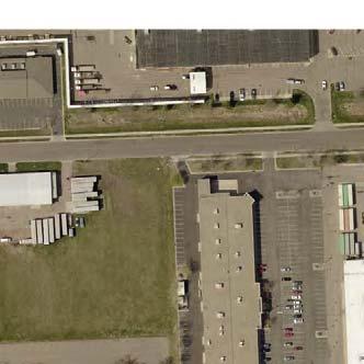
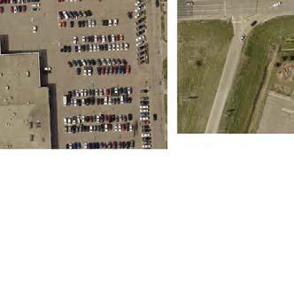
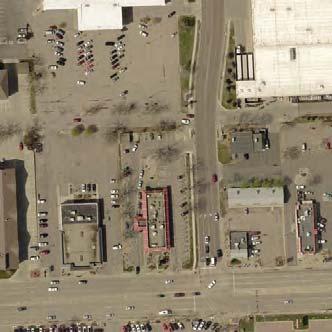
10 26th Street 21,900 23,500 SCALE IN FEET Century Theatre Domino's Legend 27,300 Daily Traffic Volume ( average) Carnavale Cracker Barrel 27,300 Daily Traffic Volume ( average) Outback River Plaza Get-n-Go Post Office Signalized Intersection Access Easement Hampton Inn Swenson Dr. Slumberland Holiday Inn Express 18,840 Culvers 21,760 Big Sioux River Staybridge Suites Foley's Home Depot SF Fed Credit Union 6000 MS Society 5840 the Vault Star Perf. Buffalo Wild Wings 18,500 20,320 18,900 HOM 20,320 I-29 Brick Co. Sturdevants Northern Tool Agan Drywall Sonic 2200 Harold's Stucco & Stone Showroom 34th Street 3700 Chevy's Abra Michaels INTERSTATE 29 Rainbow Carolyn Avenue Menards Empire Transmission Shirley Avenue Sams 24,980 23,200 Microtel Inn 38th Street Bridal Gallery Radco Walden Carpets Strip M al Savers Wal-Mart Xcite Family Fun Scarlett O'Hara's Comfort Suites Dashboard Elec. Louise Avenue ,280 29,100 Pizza Hut Comfort Inn Red Rock Inn Fryn' Pan 32,660 28,460 bp Gas Best Western Super 8 Davids Bridal McDonalds 41st Street Chili's Arby's 30,480 27,600 Barnes & Noble Drawn By: Date: Chked By: Date: Revision: 1/30/12 1/30/12 B.Miller J.Unruh 8/30/16 Existing Conditions - 41st St to 26th St Carolyn Avenue Access Analysis I-29 Exit 77 (41st Street) Interchange Modification Study Sioux Falls, SD 8/30/16 Carolyn Avenue Landowners Mtg Attachment 2 Figure 1


 I-29 NB on-ramp Red Rock Inn Fryn' Pan 2007")


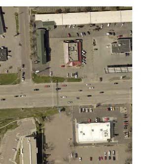
11 Scarlett O'Hara's Comfort Suites Dashboard Elec. Carolyn Avenue Legend Access Easement 0 SCALE IN FEET Direction of Vehicle Comfort Inn Existing Right-of-Way AM PM Existing Peak Hour Traffic Volumes Signalized Intersection Golf USA 4/30/2007 Date of Traffic Count 27,300 Daily Traffic Volume ( average) 27,300 Daily Traffic Volume ( average) I-29 NB on-ramp Red Rock Inn Fryn' Pan 2007 to to bp Gas Pizza Hut Arrows depict type of crash, not the direction of traffic. 32,660 28,460 41st Street 4/30/ I-29 NB off-ramp /10/ Drawn By: Date: Chked By: Date: Revision: 1/30/12 1/30/12 B.Miller J.Unruh 8/30/16 Existing Conditions at 41st St / Carolyn Ave Carolyn Avenue Access Analysis I-29 Exit 77 (41st Street) Interchange Modification Study Sioux Falls, SD 8/30/16 Carolyn Avenue Landowners Mtg Attachment 2 Figure 2


12


13
PRESENTATION WILL BEGIN AT APPROXIMATELY 6:05 P.M. I-90 EXIT 406 INTERCHANGE MODIFICATION STUDY AND ENVIRONMENTAL ASSESSMENT MARKET
 PRESENTATION WILL BEGIN AT APPROXIMATELY 6:05 P.M. MARKET I-90 EXIT 406 INTERCHANGE MODIFICATION STUDY AND ENVIRONMENTAL ASSESSMENT JANUARY 23, 2017 Public Meeting & Open House #2 TODAY S MEETING Purpose:
Technical Memo. 1. Backgound
 Technical Memo pril 12, 2017 Project: To: From: I-29 Exit 77 (41 st Street) Interchange Modification Justification Report, Project # PL0100(84) 3616P, PCN 05MH Study dvisory Team HDR Subject: 41 st Street
Meeting Location: Brookings SDDOT Office
 Meeting Notes Subject: Advisory Team Meeting #2 Client: SDDOT Project: Brookings Area MTP Project No: 144348 Meeting Date: September 30th, 2010 Meeting Location: Brookings SDDOT Office Notes by: HDR Attendees:
Subject: Solberg Avenue / I-229 Grade Separation: Traffic Analysis
 MEMORANDUM Transportation Bill Troe, AICP Jason Carbee, AICP 12120 Shamrock Plaza Suite 300 Omaha, NE 68154 (402) 334-8181 (402) 334-1984 (Fax) To: Project File Date: Subject: Solberg Avenue / I-229 Grade
APPENDIXB. Traffic Operations Technical Memorandum
 APPENDIXB Traffic Operations Technical Memorandum Environmental Assessment - Lincoln County, SD 85 th Street: Sundowner Avenue to Louise Avenue November 2017 MEMORANDUM Transportation Jim Kollbaum, PE
Fairfax County Parkway Widening Fairfax County
 Get Involved VDOT representatives will review and evaluate information received as a result of this meeting. Please fill out the comment sheet provided in this brochure if you have any comments or questions.
INNOVATIVE INTERSECTION DESIGN
 INNOVATIVE INTERSECTION DESIGN J. Eddie Valtier, P.E. ELP TP&D Director Introduction Why Do We Need To Start Looking For Innovative Intersection Designs? Congestion is worsening and traffic volumes and
Project NH 0081( )155 PCN 04YQ Codington County. US81 - Intersection of US81 & 20th Ave SE (South Connector) in Watertown. Intersection Improvements
155 PCN 04YQ Codington County. US81 - Intersection of US81 & 20th Ave SE (South Connector) in Watertown. Intersection Improvements") Public Meeting/ Open House May 20, 2014 Project NH 0081( )155 PCN 04YQ Codington County US81 - Intersection of US81 & 20th Ave SE (South Connector) in Watertown Intersection Improvements The South Dakota
Public Meeting/ Open House May 20, 2014 Project NH 0081( )155 PCN 04YQ Codington County US81 - Intersection of US81 & 20th Ave SE (South Connector) in Watertown Intersection Improvements The South Dakota
I-90 Exit 406 Interchange Modification Study and Environmental Assessment. Public Involvement #2
 I-90 Exit 406 Interchange Modification Study and Environmental Assessment Public Involvement #2 January 23, 2017 Holiday Inn Express Convention Center Brandon, SD Public Comments Summary Public Meeting
Information on display. Inside this handout. Triangle Area revisions. Project need displays. Preferred alternative on aerial maps
 Public information meeting #4 4 to 7 p.m., September 30, 2009 Hales Corners Welcome Thank you for attending this public information meeting for the WIS 100 Corridor Study. Your interest and comments are
SD Highway 50 in Yankton (4 TH Street) Reconstruction Project NH 0050(99)381 PCN By Josh Larson McLaury Engineering Inc.
 Reconstruction Project NH 0050(99)381 PCN By Josh Larson McLaury Engineering Inc.") SD Highway 50 in Yankton (4 TH Street) Reconstruction Project NH 0050(99)381 PCN 6926 By Josh Larson McLaury Engineering Inc. Project Limits SD 50 from Broadway to Burleigh and from Marne Creek to Archery
SD Highway 50 in Yankton (4 TH Street) Reconstruction Project NH 0050(99)381 PCN 6926 By Josh Larson McLaury Engineering Inc. Project Limits SD 50 from Broadway to Burleigh and from Marne Creek to Archery
Mandan Commission Meeting August 2, 2016 Mandan City Hall
 Mandan-Bismarck Corridor Improvement Study Mandan Commission Meeting August 2, 2016 Mandan City Hall 2014 HDR, Inc., all rights reserved. Mandan Corridors Study Schedule 2015 2016 Study Kick Off August
Road Safety Audit Report: Interstate 516
 Road Safety Audit Report: Interstate 516 Interstate 516 from Veterans Pkwy to Montgomery St. (State Route 420 from Veterans Pkwy to City Street 115207) Table of Contents Introduction Road Safety Audit
PEDESTRIAN ACCOMMODATIONS DPS 201 AT INTERCHANGES
 PEDESTRIAN ACCOMMODATIONS DPS 201 AT INTERCHANGES UNDERSTANDING THE ISSUES Intersections of freeway ramp terminals at crossroads are the most critical components of an interchange Challenge: balance mobility
I-20 ODESSA-MIDLAND CORRIDOR STUDY. Public Meeting for Schematic Design
 I-20 ODESSA-MIDLAND CORRIDOR STUDY Public Meeting for Schematic Design The environmental review, consultation, and other actions required by applicable Federal environmental laws for this project are being,
US14/US14B Pierre. Mark Malone, PE SD DOT
 US14/US14B Pierre Mark Malone, PE SD DOT Why are we here? To discuss the intersection of US14/14B and nearby Kingsway intersection Traffic volumes Safety Impacts Many questions regarding last summer s
COMMUNITY MEETING #1 Summary
 COMMUNITY MEETING #1 Summary October 26, 2016 LOCATION: TIME: ATTENDEES: Dr. Phillips High School Cafeteria 6500 Turkey Lake Road, Orlando, FL 32819 6:00 pm to 8:00 pm 79 citizens Commissioner Scott Boyd,
Iowa Highway 58 Corridor Improvement Study
 1 Iowa Highway 58 Corridor Improvement Study Public Informational Meeting May 6, 2014 2 Welcome and Introductions Randy Lorenzen, City of Cedar Falls Engineer 3 Outline of Presentation Review of Project
M-58 HIGHWAY ACCESS MANAGEMENT STUDY Mullen Road to Bel-Ray Boulevard. Prepared for CITY OF BELTON. May 2016
 M-58 HIGHWAY ACCESS MANAGEMENT STUDY Prepared for CITY OF BELTON By May 2016 Introduction Missouri State Highway 58 (M-58 Highway) is a major commercial corridor in the City of Belton. As development has
Mark Malone, P.E. SD DOT
 Mark Malone, P.E. SD DOT SD10 Grading & Surfacing From 8 th Ave W to 8 th Ave E 1 mile plus transition lengths Complete Urban Reconstruction Grading, C&G, Storm Sewer, Sidewalk, Concrete Surfacing Railroad
Legislative Update Williamsburg Residency
 Hampton Roads District Legislative Update Williamsburg Residency Jim Brewer, Resident Administrator 757-253-5140 Projects Under Way Warwick Boulevard Project http://www.warwickboulevard.org/ Contractors:
APPENDIX G: INTERSECTION NEEDS AT OKEECHOBEE BOULEVARD
 APPENDIX G: INTERSECTION NEEDS AT OKEECHOBEE BOULEVARD INTERSECTION NEEDS AT SR 7 and OKEECHOBEE BOULEVARD SR 7 Extension Project Development and Environment (PD&E) Study From Okeechobee Boulevard (SR
LSC TRANSPORTATION CONSULTANTS, INC. 516 North Tejon Street Colorado Springs, CO (719) FAX (719)
 FAX (719)") LSC TRANSPORTATION CONSULTANTS, INC. 516 North Tejon Street Colorado Springs, CO 80903 (719) 633-2868 FAX (719) 633-5430 E-mail: lsc@lsccs.com May 15, 2009 Mr. Davis Farrar Western Slope Consulting, LLC
LSC TRANSPORTATION CONSULTANTS, INC. 516 North Tejon Street Colorado Springs, CO 80903 (719) 633-2868 FAX (719) 633-5430 E-mail: lsc@lsccs.com May 15, 2009 Mr. Davis Farrar Western Slope Consulting, LLC
Paul Huston, P.E., Design-Build Coordinator Chuck Gonderinger, HDR Engineering. Minnesota Department of Transportation (the Department)
") To: From: Paul Huston, P.E., Design-Build Coordinator Chuck Gonderinger, HDR Engineering Date: March 20, 2001 Subject: Roadway Geometric Design Criteria Project: TH 14/218 Design-Build Project, SP 7408-29,
To: From: Paul Huston, P.E., Design-Build Coordinator Chuck Gonderinger, HDR Engineering Date: March 20, 2001 Subject: Roadway Geometric Design Criteria Project: TH 14/218 Design-Build Project, SP 7408-29,
Chapter 4 Traffic Analysis
 Chapter 4 Traffic Analysis PURPOSE The traffic analysis component of the K-68 Corridor Management Plan incorporates information on the existing transportation network, such as traffic volumes and intersection
WISCONSIN AVENUE EXTENSION SECOND PUBLIC INFORMATION MEETING. March 28, 2017
 WISCONSIN AVENUE EXTENSION SECOND PUBLIC INFORMATION MEETING March 28, 2017 STUDY AREA N MEETING AGENDA Introductions Study Background Alternatives Studied Recommended Alternative Discussion STUDY BACKGROUND
Walmart (Store # ) 60 th Street North and Marion Road Sioux Falls, South Dakota
 60 th Street North and Marion Road Sioux Falls, South Dakota") Walmart (Store #4865-00) 60 th Street North and Marion Road Sioux Falls, South Dakota Prepared for: Wal-Mart Stores, Inc. Bentonville, Arkansas Prepared by: Kimley-Horn and Associates, Inc. ã2013 Kimley-Horn
Walmart (Store #4865-00) 60 th Street North and Marion Road Sioux Falls, South Dakota Prepared for: Wal-Mart Stores, Inc. Bentonville, Arkansas Prepared by: Kimley-Horn and Associates, Inc. ã2013 Kimley-Horn
Preliminary Engineering Study
 Preliminary Engineering Study Open House # 2 June 6, 2018 PREPARED FOR: PREPARED BY: Agenda Background and status of preliminary engineering study County Road 26 design summary County Road 63 design summary
APPENDIX A TRAFFIC ANALYSIS
 APPENDIX A TRAFFI ALYSIS 1) 9/15/06 Traffic Analysis Memo; revised 9/29/06, 11/1/06, and 1/02/07 2) 7/6/09 SDDOT Traffic Analysis Recommendations for SD20/US81 Intersection Memo To: Watertown South onnector
Updated There is no park access roadway to be constructed points beyond the limit of along full limits of the park's the phase I work. Phase 1. Revise
 The signs will be installed as Temporary signs the color (Orange/White) have been added to the plans. Need to specify color to be used for stripes. Closures that may be in place for extended periods need
Interstate Route 77 / US Route 62 / State Route 687 (Fulton Road) Transportation Improvement Project. Prepared September 6, 2017
 Transportation Improvement Project. Prepared September 6, 2017") EODOT Project: ODOT Project: STA-IR 77-.50; PID 00290 Interstate Route 77 / US Route 62 / State Route 687 (Fulton Road) Transportation Improvement Project Summary of Public Comments Received and Responses
EODOT Project: ODOT Project: STA-IR 77-.50; PID 00290 Interstate Route 77 / US Route 62 / State Route 687 (Fulton Road) Transportation Improvement Project Summary of Public Comments Received and Responses
APPENDIX E Evaluation of Improvement Alternatives
 APPENDIX E Evaluation of Improvement Alternatives Table E-1 Preliminary Comparison of Design Alternatives, Concord Table E-2 Preliminary Comparison of Route 2 Improvement Packages, Acton and Concord TABLE
A number of inferences have been drawn from the observations, each of which is discussed below.
 Technical Memo To: Steve Gramm, Study Advisory Team From: Rick Laughlin Project: I-190/Silver St. CC: Date: 4/4/2011 Job No: RE: Special event observation HDR conducted an observation of special event
Route 7 (East Market Street) Interchange at Battlefield Parkway Town of Leesburg Project No: UPC Presentation to Town Council
 Interchange at Battlefield Parkway Town of Leesburg Project No: UPC Presentation to Town Council") Route 7 (East Market Street) Interchange at Battlefield Parkway Town of Leesburg Project No: 0007-253-109 UPC 106573 Presentation to Town Council June 26, 2017 Council Decisions East Market Street / Battlefield
Route 7 (East Market Street) Interchange at Battlefield Parkway Town of Leesburg Project No: 0007-253-109 UPC 106573 Presentation to Town Council June 26, 2017 Council Decisions East Market Street / Battlefield
FY STATEWIDE TRANSPORTATION IMPROVEMENT PROGRAM New Jersey Department of Transportation Projects
 ROUTE/ Project ID No. TIP No. Electrical Load Center Replacement - North 04324 04324 This project will provide for the betterment of the existing highway lighting facilities located along Routes 3, 17
I-264 CORRIDOR EVALUATION STUDY. September 7, 2016 Eric Stringfield VDOT Planning Director Chris Lawrence AECOM Senior Transportation Engineer
 I-264 CORRIDOR EVALUATION STUDY September 7, 2016 Eric Stringfield VDOT Planning Director Chris Lawrence AECOM Senior Transportation Engineer Study Overview Interchange Locations Study Context Follow-up
HIGHBURY AVENUE/HAMILTON ROAD INTERSECTION IMPROVEMENTS PUBLIC INFORMATION CENTRE 1 MAY 14, 2015
 HIGHBURY AVENUE/HAMILTON ROAD INTERSECTION IMPROVEMENTS Municipal Class Environmental Assessment PUBLIC INFORMATION CENTRE 1 MAY 14, 2015 ACCESSIBILITY Under the Accessibility Standards 2015 for Customer
CSAH 101 Preliminary Design
 CSAH 101 Preliminary Design Public Open House No. 2 January 29, 2013 CSAH 62 to Hutchins Drive Welcome / Introductions Hennepin County Craig Twinem, Transportation Maury Hooper, Transportation Nick Peterson,
Proposed Action, Purpose and Need Technical Memorandum
 Proposed Action, Purpose and Need Technical Memorandum MoPac (State Loop 1) Intersections, Austin District From North of Slaughter Lane to South of La Crosse Avenue CSJ: 3136-01-015 Travis County, Texas
Cincinnati Dayton Rd Widening
 Cincinnati Dayton Rd Widening Project Overview Widening of Cincinnati Dayton Rd to four lanes - providing a center turn lane and an additional northbound lane Realignment of Station Rd Widening of bridge
Updated There is no park access points beyond the limit of the phase I work. roadway to be constructed Viewport has been along full limits of the park
 The signs will be installed as Temporary signs the color (Orange/White) have been added to the plans. Need to specify color to be used for stripes. Closures that may be in place for extended periods need
WELCOME. FM 2818 (Harvey Mitchell Parkway) Open House. Tuesday, Nov. 14, 2017
 Open House. Tuesday, Nov. 14, 2017") WELCOME FM 2818 (Harvey Mitchell Parkway) Open House Tuesday, Nov. 14, 2017 Why am I here? Review the planned improvements Provide comments on the proposed project The environmental review, consultation,
WELCOME FM 2818 (Harvey Mitchell Parkway) Open House Tuesday, Nov. 14, 2017 Why am I here? Review the planned improvements Provide comments on the proposed project The environmental review, consultation,
Description: Widen I-64 to 6 lanes from I-265 to the KY 53 interchange in Shelby County.
 I-64 KIPDA ID # 350 Project Type: ROADWAY CAPACITY Description: Widen I-64 to 6 lanes from I-265 to the KY 53 interchange in Shelby County. Purpose: Project will improve capacity and address safety concerns.
Frequently Asked Questions
 Frequently Asked Questions Business US 190 in Copperas Cove From Avenue D to Constitution Drive What is access management? A. Access Management is a growing effort by government agencies to improve how
SIOUX FALLS MPO 2018 OBLIGATED TRANSPORTATION IMPROVEMENT PROJECTS
 TOTAL LETTING DATE AWARD DATE NOTES Interstate Maintenance s 2.00 IM 0020(155) 04X N McCook Minnehaha 0.0 Mitchell Region on I90 Scour Protection $873,000 $960,000 Cancelled $0 $0 Minor Arterial 1.00 Minor
Public Involvement Outreach Requirements for Public Information Open House Meeting: C.N , HSIP-5003(12) 132 nd and West Center Road, Omaha
 132 nd and West Center Road, Omaha") To: NDOR Environmental From: Randy McCart, HDR Date: 4 April 2017 RE: Public Involvement Summary Report, HSIP-5003(12) 132 nd and West Center Road, Omaha; C.N. 22629 Public Involvement Outreach Requirements
To: NDOR Environmental From: Randy McCart, HDR Date: 4 April 2017 RE: Public Involvement Summary Report, HSIP-5003(12) 132 nd and West Center Road, Omaha; C.N. 22629 Public Involvement Outreach Requirements
122 Avenue: 107 Street to Fort Road
 : 107 Street to Fort Road November 24, 2015 4:30 8:00 p.m. Meeting Purpose Summarize project work completed to date Share results of public input from Phase 1 Share the draft concept plan and proposed
City of Madison, East Johnson Street North Baldwin Street to First Street Local Street Dane County
 City of Madison, East Johnson Street North Baldwin Street to First Street Local Street Dane County Public Involvement Meeting Thursday, April 28, 2016 6 to 8 P.M. Lapham Elementary School 1045 E. Dayton
Date: September 7, Project #: Re: Spaulding Youth Center Northfield, NH Property. Traffic Impact Study
 To: Ms. Susan C. Ryan Spaulding Youth Center 72 Spaulding Road Northfield, NH 03276 Date: September 7, 2017 Project #: 52455.00 From: Robin Bousa Director of Transportation Systems Re: Spaulding Youth
HIGHWAY 11 CORRIDOR STUDY
 HIGHWAY 11 CORRIDOR STUDY Executive Summary August 2016 Roseau County?æA@?çA@ Warroad Lake of the Woods Roseau Roosevelt Badger?ÄA@ Greenbush Legend N Hwy 11 Study Area Figure 1: Corridor Study Limits
FY STATEWIDE TRANSPORTATION IMPROVEMENT PROGRAM New Jersey Department of Transportation Projects
 Barclay Street Viaduct NS9807 NS9807 This project will provide for the rehabilitation of the Barclay Street Viaduct, from Route 19 to Marshall Street, in order to increase the weight load of the structure.
Summary: Mercer County Princeton Avenue & Spruce Street Study January 2009
 Summary: Several recent studies have assessed potential development and redevelopment opportunities in the Mercer Crossing area of Trenton, Ewing, and Lawrence. This Princeton Avenue and Spruce Street
City of Moorhead Committee of the Whole Meeting
 City of Moorhead Committee of the Whole Meeting Corridor Study Limits Center Avenue (Red River to 8th Street) TH 10 (Red River to TH 336) TH 75 (20th Ave S to Main Avenue) 2 Study Need: Project Overview
I-215 / NEWPORT ROAD INTERCHANGE PROJECT PRESS KIT
 I-215 / NEWPORT ROAD INTERCHANGE PROJECT PRESS KIT March I-215 / NEWPORT ROAD INTERCHANGE PROJECT Fact Sheet Project Overview This project will reconstruct the existing interchange located on Interstate
PERFORMANCE ACTIVITY 613 IMPACT ATTENUATOR WORK DESCRIPTION 3
 PERFORMANCE ACTIVITY 613 IMPACT ATTENUATOR WORK DESCRIPTION 1 WORK DESCRIPTION 2 WORK DESCRIPTION 3 Install Remove Repair 613 IMPACT ATTENUATOR ACTIVITY DESCRIPTION Repair, install, remove and maintain
Route 29 Corridor Assessment Update. Development of Possible Solutions
 Route 29 Corridor Assessment Update Development of Possible Solutions Public Workshop #3 October 27, 2016 Purpose of Developing Possible Solutions Recap of where we ve been and timeline for moving forward
IH 20 RANGER HILL PUBLIC MEETING
 IH 20 RANGER HILL PUBLIC MEETING AUGUST 25, 2015 IH 20, Eastland County, TX CSJ 0007-06-084 IH 20 from 3.5 mi. East of LP 254 to SH 16 (Ranger Hill) August 25, 2015 Agenda Introductions Purpose of the
Poor pavement condition Substandard Intersections. / Substandard bike/pedestrian/transit accommodations. Driveway access Environmental concerns
 Public Informational Meeting University Avenue (Allen Boulevard Segoe Road) March 23, 2011 City of Madison City of Middleton Village of Shorewood Hills Dane County Existing Roadway Conditions Poor pavement
APPENDIX E GRADE CROSSING LOCATIONS
 APPENDIX E GRADE CROSSING LOCATIONS 1 2 3 Citrus Avenue Riverside County and City Palmyrita Avenue Columbia Avenue MP 0.57 002X-0.6 027301Y MP 1.00 002X-1.0 027302F MP 1.24 002X-1.3 027303M 1. Existing
INGHAM COUNTY ROAD DEPARTMENT AUSTIN E. CAVANAUGH ADMINISTRATION BUILDING 301 Bush Street, P.O. Box 38, Mason, MI
 INGHAM COUNTY ROAD DEPARTMENT AUSTIN E. CAVANAUGH ADMINISTRATION BUILDING 301 Bush Street, P.O. Box 38, Mason, MI 48854-0038 March 27, 2018 William M. Conklin, P.E. Managing Director FOR IMMEDIATE RELEASE:
Final Sidewalk Feasibility Study
 Garfield Drive From Anastasia Drive to Elizabeth Place City of South Daytona July 23, 2009 Final Sidewalk Feasibility Study Prepared for: Prepared by: Final Sidewalk Feasibility Study Garfield Drive 2
Design Criteria. Design Criteria
 F Design Criteria Design Criteria Ministry of Transportation Ministère des Transports DESIGN CRITERIA Page: 1 of 13 WORK PROJECT NO. N/A GO Bloomington Station TYPE OF PROJECT LOCATION Bloomington Road
Glenn Avenue Corridor Traffic Operational Evaluation
 Glenn Avenue Corridor Traffic Operational Evaluation PREPARED FOR: THE CITY OF AUBURN PREPARED BY: DECEMBER 2007 Glenn Avenue Corridor Study--Auburn, Alabama TABLE OF CONTENTS Introduction... 1 Background
FINAL DESIGN TRAFFIC TECHNICAL MEMORANDUM
 FINAL DESIGN TRAFFIC TECHNICAL MEMORANDUM July 2014 FINAL (SR 43) Project Development and Environment Study From State Road 60 (Adamo Drive) to I-4 (SR 400) Hillsborough County, Florida Work Program Item
Table 1.0 Grade Crossing Enhancements PVL San Jacinto Branch Line
 Grade Crossing Enhancements CPUC 1 2 3 4 5 Citrus Avenue, Riverside County Palmyrita Ave., Columbia Avenue, Marlborough Ave., Spruce St., MP 0.57 002X-0.6 027301Y MP 1.00 002X-1.0 027302F MP 1.24 002X-1.3
TABLE OF CONTENTS. General Information General Pre-Game Timeline... 5 Directions to Sam Hood Field... 6 Hotels... 7 Restaurants...
 2008 Visitor s Guide 1 Marshall Women s Soccer TABLE OF CONTENTS General Information... 3-4 General Pre-Game Timeline... 5 Directions to Sam Hood Field... 6 Hotels... 7 Restaurants... 8 2 2008 Visitor
SH-6 Corridor Improvement Study Policy Committee Progress Report M O N D AY, J U N E 1 0, B R A Z O S C E N T E R
 SH-6 Corridor Improvement Study Policy Committee Progress Report M O N D AY, J U N E 1 0, 2 0 1 3 B R A Z O S C E N T E R Project Overview Study Goals and Objectives» Improve traffic flow» Reduce delay»
#!! "$% ##! &! # '#! % $ #!
 Executive Summary US Highway 16 (US 16) is the primary corridor connecting Rapid City to the Black Hills region. It serves a growing population of commercial and residential traffic, as well as seasonal
Project Update May 2018
 Project Update May 2018 Dakota County, in cooperation with the City of Lakeville, is planning to reconstruct 202 nd Street West (County Road 50) from Holyoke Avenue to Cedar Avenue (County Road 23). 202
Fields of St. Croix HOA Meeting. October 27, 2016
 Fields of St. Croix HOA Meeting October 27, 2016 Welcome! Why are we here? Update on Manning Avenue Phase 2 Project: Project Design Schedule Project Background Importance of Manning Avenue: Primary north-south
Highway 49, Highway 351 and Highway 91 Improvements Feasibility Study Craighead County
 Highway 49, Highway 351 and Highway 91 Improvements Feasibility Study Craighead County Executive Summary March 2015 Highway 49, Highway 351 and Highway 91 Improvements Feasibility Study Craighead County
PROJECT P 0010(91)358 PCN 028U Roberts County
358 PCN 028U Roberts County") Public Meeting/ Open House April 15, 2013 PROJECT P 0010(91)358 PCN 028U Roberts County SD10 - Fm the west city limits to 458th Ave (8th Ave) East in Sisseton Grading & PCC Surfacing, C&G, Lighting, Replace
Public Meeting/ Open House April 15, 2013 PROJECT P 0010(91)358 PCN 028U Roberts County SD10 - Fm the west city limits to 458th Ave (8th Ave) East in Sisseton Grading & PCC Surfacing, C&G, Lighting, Replace
CHAPTER 3 STUDY AREA OPERATIONAL OVERVIEW
 HPTER 3 STUY RE OPERTIONL OVERVIEW This chapter describes the overall traffic operations within the study area under existing and future conditions and focuses on individual intersections not directly
Legislative Update. Frederick County Fall Staunton District. Interstate 81 - Exit 300 at Interstate 66 Southbound Acceleration Lane Extension
 Interstate 81 - Exit 300 at Interstate 66 Southbound Acceleration Lane Extension Application ID 1643 Northern Shenandoah Valley Regional Commission (NSVRC) $3,437,423 This project extends the Interstate
Meeting Schedule 7:00-7:15 Open House 7:15-7:45 Existing Conditions/Short-Term Improvements Study Presentation 7:45-8:00 Q&A Session 8:00-8:10
 Meeting Schedule 7:00-7:15 Open House 7:15-7:45 Existing Conditions/Short-Term Improvements Study Presentation 7:45-8:00 Q&A Session 8:00-8:10 Long-Term Study Presentation 8:10-8:40 Table Discussions 8:40-9:00
Date: 09/22/2016 Subject: To: From: PennDOT Engineering District 5-0. Dear Applicant,
 Date: 09/22/2016 Subject: Highway Occupancy Permit Application No. 112807 Returned For Revisions To: Wal-Mart Real Estate Business Trust 2001 SE 10th Street Bentonville, AR 72716 From: PennDOT Engineering
I-95/Temple Avenue Improvements Project Colonial Heights, VA
 I-95/Temple Avenue Improvements Project Colonial Heights, VA Pardon Our Dust Informational Meeting February 3, 2016 Harold Dyson, P.E. Construction Manager, Richmond District Tom Heil, P.E. Allan Myers
State Route 160 (Blue Diamond Highway)
") State Route 160 (Blue Diamond Highway) ~ Multi-Year Expansion Program ~ Highway Improvement Projects in Clark and Nye Counties EXHIBIT G Treasures Document consists of 16 slides. Entire exhibit provided.
State Route 160 (Blue Diamond Highway) ~ Multi-Year Expansion Program ~ Highway Improvement Projects in Clark and Nye Counties EXHIBIT G Treasures Document consists of 16 slides. Entire exhibit provided.
INTERSECTION IMPROVEMENTS
 MCHENRY COUNTY DIVISION OF TRANSPORTATION SEPTEMBER 2012 RIVER ROAD AT DOWELL ROAD INTERSECTION IMPROVEMENTS INSIDE: Public Meeting #1 Summary 1 Public Meeting #2 Summary 1 Key Issues Raised at Public
Bicycle - Motor Vehicle Collisions on Controlled Access Highways in Arizona
 Bicycle - Motor Vehicle Collisions on Controlled Access Highways in Arizona Analysis from January 1, 1991 to June 30, 2002 Richard C. Moeur, PE Traffic Design Manager, Northern Region Michelle N. Bina
TRAFFIC ACTION PLAN. Laurie Meadows Neighborhood CITY OF SAN MATEO
 TRAFFIC ACTION PLAN Laurie Meadows Neighborhood CITY OF SAN MATEO Draft January 2017 Table of Contents Introduction... 2 The Traffic Forum Process... 5 Neighborhood Traffic Issues... 7 Neighborhood Recommendations
MoPac South: Impact on Cesar Chavez Street and the Downtown Network
 MoPac South: Impact on Cesar Chavez Street and the Downtown Network Prepared by: The University of Texas at Austin Center for Transportation Research Prepared for: Central Texas Regional Mobility Authority
Intersection Traffic Control Feasibility Study
 Intersection Traffic Control Feasibility Study CSAH 9 at CSAH 60 (185th Avenue) Prepared For: Dakota County Transportation Department Western Service Center 14955 Galaxie Avenue, 3rd Floor Apple Valley,
Offset Single Point Interchange I-25 at Rio Bravo Boulevard Albuquerque, New Mexico
 Offset Single Point Interchange I-25 at Rio Bravo Boulevard Albuquerque, New Mexico INSTITUTE OF TRANSPORTATION ENGINEERS 2016 WESTERN DISTRICT MEETING JULY 11, 2016 7/11/2016 1 Project Vicinity Map 7/11/2016
Scarlett Road Bridge & Road Improvements Lambton Park Community School - Gymnasium Tuesday November 28 th, 2017
 Scarlett Road Bridge & Road Improvements Lambton Park Community School - Gymnasium Tuesday November 28 th, 2017 PROJECT LOCATION 2 SCARLETT ROAD BRIDGE Constructed in 1912, the bridge carries 4 active
King Soopers #116 Thornton, Colorado
 Traffic Impact Study King Soopers #116 Thornton, Colorado Prepared for: Galloway & Company, Inc. 1.0 EXECUTIVE SUMMARY King Soopers #116, a grocery marketplace anchored commercial development, is proposed
Donahue Drive Corridor Traffic Operational Evaluation
 Donahue Drive Corridor Traffic Operational Evaluation PREPARED FOR: THE CITY OF AUBURN PREPARED BY: JANUARY 2007 Donahue Drive Corridor Study--Auburn, Alabama TABLE OF CONTENTS Introduction... 1 Background
A-1 Arcadia with Signal
 A-1 Arcadia with Signal Dakota St Variation: Half 3/4 with westbound left at Main 4 - Fewer downtown access points - Less efficient traffic operations - Highest project costs vanston. ote: traffic volumes
PAT Meeting #2 Future Alternatives Meeting Agenda
 PAT Meeting #2 Future Alternatives Meeting Agenda Future Build Alternatives Discussion August 18, 2017 Viera Gov't Center, Atlantic Room, Building C, 3rd Floor 9:00 AM 11:00 AM 1. Schedule Update 2. Issues/Opportunities
City of Madison, East Johnson Street North Baldwin Street to First Street Local Street Dane County
 City of Madison, East Johnson Street North Baldwin Street to First Street Local Street Dane County Public Involvement Meeting Thursday, November 10, 2016 5:30 to 7 P.M. Festival Foods 810 E. Washington
May 10, 2013 Meredith Cruz, (561) Palm Beach County Traffic Report May 10 through May 17, 2013
 Palm Beach County Traffic Report May 10 through May 17, 2013") May 10, 2013 Meredith Cruz, (561) 641-6440 mcruz@corradino.com Palm Beach County Traffic Report May 10 through May 17, 2013 Palm Beach County Palm Beach County traffic will be affected this week by ongoing
May 10, 2013 Meredith Cruz, (561) 641-6440 mcruz@corradino.com Palm Beach County Traffic Report May 10 through May 17, 2013 Palm Beach County Palm Beach County traffic will be affected this week by ongoing
ROAD SAFETY AUDIT. Route 114 at Interstate I-495 Northbound Ramps. City of Lawrence. July 30, 2015
 ROAD SAFETY AUDIT Route 114 at Interstate I-495 Northbound Ramps City of Lawrence July 30, 2015 Prepared For: Massachusetts Department of Transportation Prepared By: Toole Design Group 33 Broad Street,
CITY OF WEST LAKE HILLS. Forest View Neighborhood Traffic Calming Study
 CITY OF WEST LAKE HILLS 901 South Mopac Expressway Building V, Suite 220 Austin, Texas 78746 Texas P.E. Firm Registration No. F-929 Klotz Associates Final Report Submittal: March 20, 2015 Revised Final
Capital Region Council of Governments
 March 23, 2018 Capital Region Council of Governments PROJECT CONCEPT REPORT Realignment of Swamp and Northfield Road s approaches to Route 44 (Boston Turnpike) Town of Coventry SUMMARY: The Town of Coventry
Stakeholder Focus Group Meeting #3 January 9, 2013 Cattlemens, 2000 Taylor Road, Roseville
 PRESENT Stakeholder Focus Group Meeting #3 January 9, 2013 Cattlemens, 2000 Taylor Road, Roseville PROJECT TEAM REPRESENTATIVES Name Organization Celia McAdam Luke McNeel Caird Leo Heuston Judy Matsui
CITY OF OTTAWA ROADWAY MODIFICATION APPROVAL UNDER DELEGATED AUTHORITY
 RMA-2015-ATM-038 CITY OF OTTAWA ROADWAY MODIFICATION APPROVAL UNDER DELEGATED AUTHORITY DATE: April 22, 2015 SUBJECT Approval of Roadway Modifications Recommended through an Area Traffic Management Study
City of Wayzata Comprehensive Plan 2030 Transportation Chapter: Appendix A
 A1. Functional Classification Table A-1 illustrates the Metropolitan Council s detailed criteria established for the functional classification of roadways within the Twin Cities Metropolitan Area. Table
2016 Church Street Access Study. 100 Clinton Square 126 North Salina Street, Suite 100 Syracuse, NY
 2016 Church Street Access Study 100 Clinton Square 126 North Salina Street, Suite 100 Syracuse, NY 13202 www.smtcmpo.org Syracuse Metropolitan Transportation Council Final Report February 23, 2016 This
Traffic Signal Phasing Study Summary & Staff Recommendations
 Traffic Signal Phasing Study Summary & Staff Recommendations Consultant Study by Skipper Consulting, Inc. Staff Committee Recommendations by Randy Pewitt, Executive Director of Emergency Mgt. and Safety
Corridor Studies. LA 415 and LA 73
 Corridor Studies LA 415 and LA 73 Project Approach for Both Corridors 1. Data Collection 2. Data Summary 3. Traffic Analysis 4. Micro-Simulation modeling 5. Generation of alternatives 6. Modeling alternatives