JACKSON PARK REVITALIZATION TRAFFIC IMPACT STUDY FINAL REPORT
|
|
|
- Oscar Gallagher
- 6 years ago
- Views:
Transcription


1 JACKSON PARK REVITALIZATION TRAFFIC IMPACT STUDY FINAL REPORT Submitted to: Prepared by: February 2018
2 EXECUTIVE SUMMARY The City of Chicago and Chicago Park District are considering a large-scale revitalization plan for Jackson Park updating the South Lakefront Framework Plan that would increase green space, improve pedestrian connectivity, and create new and upgraded facilities. Part of that plan is the construction of the future Obama Presidential Center (OPC), which would be located on a site between Stony Island Avenue and Cornell Drive, just south of the Midway Plaisance, and is anticipated to be operational in late A second planned project would merge the Jackson Park and South Shore golf courses located south of Hayes Drive as part of a plan to redesign and upgrade those public golf facilities. As part of the updated South Lakefront Framework Plan, the following roadway segments within Jackson Park would be closed and converted into open space: Cornell Drive between North Midway Plaisance and Hayes Drive South Midway Plaisance between Stony Island Avenue and Cornell Drive Marquette Drive between Stony Island Avenue and Richards Drive Northbound Cornell Drive from 68 th Street to where Cornell Drive becomes two-way (approximately midway between 64 th Street and 65 th Street) A traffic impact analysis was performed to identify potential traffic impacts associated with the proposed project. The future traffic volume projections to the 2040 horizon year accounted for the reassignment of traffic due to the proposed roadway closure, background traffic growth, and trips generated by the OPC development. The Chicago Metropolitan Agency for Planning (CMAP) assisted with the development of future traffic volumes based on their in-house travel demand model, which provided projections for the reassignment of Cornell Drive traffic volumes to alternate routes as well as general background growth associated with the expected economic growth of nearby neighborhoods and other known development projects between 2016 and Traffic Impact Analysis The study area is generally bounded by Lake Shore Drive (US 41) to the east, Stony Island Avenue to the west, 57 th Drive to the north, and 67 th Street to the south and includes 36 intersections where traffic data was collected in October Traffic analyses were performed using the Synchro/SimTraffic software package for the weekday AM and PM peak hours, and the capacity analysis results were compared for the following conditions: 2016 Existing Condition (baseline conditions for the current year) 2040 No Build Condition (future conditions without the proposed OPC and roadway closures) 2040 Build Condition (future conditions with the proposed OPC and roadway closures) Final Report February 2018 ii
3 Mitigation Traffic mitigation in the form of signal timing and phasing changes, parking regulation changes, and capital improvements along key roadways and at key intersections to increase capacity would be implemented along with the roadway closures to accommodate the changes in traffic patterns. The recommended mitigation measures that would successfully offset any potential traffic impacts are summarized in the table on the next page. By providing acceptable levels of service for traffic flow, bus transit demand can also be accommodated through the future horizon year. The 2040 Build Condition includes proposed mitigation measures and is compared to the 2040 No Build Condition to identify potential traffic impacts. The traffic analysis results show that the proposed improvements would successfully mitigate any potential traffic impacts in the 2040 horizon year and there would be no significant traffic impacts as a result of the proposed project. Parking Analysis A parking analysis was performed that shows the proposed on-site parking would be sufficient to accommodate the projected peak parking demand for the OPC site. Due to the proposed roadway changes, there would be a net loss in on-street parking supply of 236 spaces within the study area, leaving a total on-street parking supply of 569 spaces, which can still accommodate the surveyed peak demand of 270 parked cars. There is additional parking availability for a fee in the public parking lots within Jackson Park. Final Report February 2018 iii
4 Location Lake Shore Dr between 57th Dr and Hayes Dr Lake Shore Dr & 57th Dr intersection Lake Shore Dr & Science Dr intersection Lake Shore Dr & Hayes Dr intersection Hayes Dr between Richards Dr and Cornell Dr Hayes Dr & Richards Dr intersection Hayes Dr & Cornell Dr intersection Stony Island Ave between 59th St & 60th St Stony Island Ave between 60th St & 65th St Stony Island Ave & 63rd St/Hayes Dr intersection Stony Island Ave & 64th St intersection Stony Island Ave & Southbound Cornell Drive Stony Island Ave & Marquette Dr intersection 67th St & Stony Island Ave intersection 57th Dr & Hyde Park Blvd/Museum Dr intersection North Midway Plaisance & 57th Dr/MSI Garage Driveway intersection 67th St & Jeffery Ave intersection Lake Shore Dr/Jeffery Ave & Marquette Dr intersection 67th St & South Shore Drive Proposed Mitigation/Improvements Increase from two to three southbound travel lanes Widen travel way on 59th St Harbor Bridge to provide six lanes Widen pedestrian underpass structure north of Hayes Dr Geometric modifications within existing curb to curb width Lane configuration changes Modify signal timing Geometric and lane modifications within existing curb to curb width Modify signal timing and phasing Intersection widening to accommodate continuous flow right turn lane from SB Lake Shore Drive Intersection widening of Hayes approach to provide 3 left turn lanes Add new crosswalk across south leg Modify signal timing and phasing Provide a N S pedestrian underpass on west leg of Hayes Dr. Restripe section with 2 travel lanes in each direction with a physical median. Prohibit on street parking along both curbs lengths Consolidate 3 separate intersections into a single T intersection Install new traffic signal Widen Hayes Dr slightly to north at intersection Remove north leg of intersection Modify intersection geometry to facilitate WB SB leg alignment Remove at grade crosswalks and replace with two pedestrian underpasses across west and south legs Modify signal timing and phasing Widen Stony Island Ave to east to provide new NB right turn lane Restripe Stony Island Ave between North Midway Plaisance and South Midway Plaisance to accommodate 5 travel lanes Remove traffic signals at 59th and 60th Streets and geometrically restrict intersection to Right In / Right Out operation Remove east leg of South Midway Plaisance/Stony Island Avenue intersection Modify traffic signals equipment at Stony Island Ave / South Midway Plaisance and Stony Island Ave / North Midway Plaisance intersections Modify traffic signal timing and phasing Widen Stony Island Ave to east to allow for upgraded cross section New cross section will provide 2 travel lanes and a parking lane in each direction with a landscaped median/left turn lane Provide pedestrian bump outs and refuge islands at intersections. Add a NB LTL on Stony Island Avenue with 65th Place Modify signal timing Provide NB/SB left turn arrows Extend SB left turn lane Install traffic signal Convert WB Cornell Dr approach to two way and widen approach for two lanes in each direction Provide two NB Right Turn lanes Modify signal timing Remove east leg of intersection Modify Signal Timing Remove segment of NB Cornell Dr and Intersection with 67th St Widen NB Stony Island with an additional travel lane. Modify signal timing Restripe EB/WB approaches to provide exclusive LTLs, Extend NB and SB LTLs Add WB RTL on 67th Street Modify signal timing Modify signal timing Modify signal timing Provide a pedestrian underpass along Jeffery Avenue between 67th and Marquette Dr Modify signal timing Provide a pedestrian underpass on the north leg of intersection Modify signal timing Final Report February 2018 iv
5 TABLE OF CONTENTS EXECUTIVE SUMMARY... ii 1.0 INTRODUCTION South Lakefront Framework Plan (1999) Obama Presidential Center Site Study Area and Study Locations EXISTING TRANSPORTATION SYSTEM Roadway System Characteristics Public Transit Pedestrian/Bicycle Facilities TRAFFIC VOLUMES Existing Traffic Volumes Future Traffic Volumes TRAFFIC IMPACT ANALYSIS Capacity Analysis Methodology Existing Conditions No Build Conditions Recommended Mitigation Build Conditions (with Mitigation) PARKING ANALYSIS Existing Parking Conditions On-Site Parking Analysis Off-Site Parking Analysis OPC SITE AND CURBSIDE CHARACTERISTICS Service Access and Loading Docks Garage Access Pedestrian Access Bike Facilities Curbside Operations CONCLUSION Final Report February 2018 v
6 LIST OF FIGURES Figure 1-1: Location of Proposed Developments and Roadway Closures Figure 1-2: Obama Presidential Center (OPC) Preliminary Site Plan Figure 1-3: Study Intersection Locations Figure 2-1: Existing Street Characteristics Figure 2-2: Existing Transit Network Figure 2-3: Existing and Planned Bicycle Route/Trail Network Figure 3-1:Average Daily Traffic Volumes Figure 3-2: Cornell Drive Hourly Traffic Volumes Figure 3-3: Existing Volumes AM Figure 3-4: Existing Volumes PM Figure 3-5: Existing Pedestrian and Bicycle Volumes Figure 3-6: OPC Site Generated Traffic AM Figure 3-7: OPC Site Generated Traffic PM Figure 3-8:2040 No-Build Traffic Volumes AM Figure 3-9:2040 No-Build Traffic Volumes PM Figure 3-10: 2040 Build Traffic Volumes AM Figure 3-11:2040 Build Traffic Volumes PM Figure 4-1: Proposed Mitigation Measures Figure 4-2: Lake Shore Drive at 57 th Drive, Third SB Lane Figure 4-3: Lake Shore Drive at Science Drive, Third SB Lane Figure 4-4: Lake Shore Drive at 59 th Street Harbor Bridge, Third SB Lane Figure 4-5: Lake Shore Drive at Hayes Drive, Third SB Lane Figure 4-6: Hayes Drive and Richards Drive Mitigation Figure 4-7: Hayes Drive and Cornell Drive Mitigation Figure 4-8: Stony Island Avenue at Midway Plaisance / 59 th Street / 60 th Street Mitigation Figure 4-9: Stony Island Avenue between 68 th Street and 65 th Place/SB Cornell Mitigation Figure 4-10: Cornell Drive Road Diet Concept Figure 5-1: Existing Public Parking Locations Figure 5-2: Parking Demand Calculator Figure 5-3: OPC Hourly Parking Demand Figure 6-1: OPC Curbside Loading and Access Plan Final Report February 2018 vi
7 LIST OF TABLES Table 2-1: Study Area CTA Bus Routes Table 3-1: Cornell Drive Peak Hour Volumes from Intersection Counts Table 3-2: Cornell Drive Traffic Reassignment Table 3-3: Reassignment of Traffic to Alternate North/South Routes (Source: CMAP) Table 3-4: Average Growth Rates by Corridor ( ) Table 3-5: Vehicle Trip Generation for 30 th Design Day Table 4-1: LOS Criteria for Signalized Intersections Table 4-2: LOS Criteria for Unsignalized Intersections Table 4-3:Existing Condition Signalized LOS Table 4-4: Existing Condition Unsignalized LOS Table 4-5: 2040 No-Build Condition Signalized LOS Table 4-6: 2040 No-Build Condition Unsignalized LOS Table 4-7: Hayes Drive and Richard Drive Warrant Analysis Table 4-8: Stony Island Avenue and 64 th Street Warrant Analysis Table 4-9: 2040 Build Condition Signalized LOS Table 4-10: 2040 Build Condition Unsignalized LOS Table 5-1: On-Street Parking Supply Table 5-2: Parking Utilization LIST OF APPENDICES (to be provided electronically) APPENDIX A: Raw Traffic Data APPENDIX B: CMAP Memorandum APPENDIX C: OPC Trip Generation and Parking Demand Details APPENDIX D: Detailed Traffic Volume Increments APPENDIX E: Traffic Signal Timings and Pavement Striping Plans (from CDOT) APPENDIX F: Synchro/SimTraffic Files APPENDIX G: Travel Time Comparisons Final Report February 2018 vii
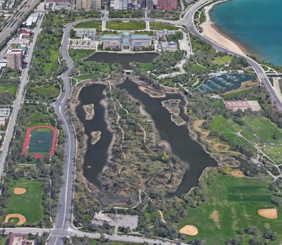
8 1.0 INTRODUCTION The City of Chicago and Chicago Park District are considering a large-scale revitalization plan for Jackson Park that would increase green space, improve pedestrian connectivity, and create new and upgraded facilities. Part of that plan is the construction of the future Obama Presidential Center (OPC), which would be located on a site between Stony Island Avenue and Cornell Drive, just south of the Midway Plaisance, and is anticipated to be operational in late A second potential large-scale project would merge the Jackson Park and South Shore golf courses located south of Hayes Drive as part of a plan to redesign and upgrade those public golf facilities. The approximate locations of the OPC and golf course projects as well as the proposed roadway closures are shown on Figure 1-1. As shown in the figure, Cornell Drive would be closed and vacated between North Midway Plaisance and Hayes Drive, and South Midway Plaisance would be closed and vacated between Stony Island Avenue and Cornell Drive (Segment A on the figure). In addition, Marquette Drive between Stony Island Avenue and Richards Drive and Cornell Drive Northbound between 68 th Street and approximately midway between 64 th Street and 65 th Street would be closed and vacated (Segments B and C on the figure, respectively). Traffic mitigation in the form of signal timing and phasing changes, parking regulation changes, and capital improvements along key roadways and at key intersections would be implemented along with the roadway closures to accommodate the changes in traffic patterns. By providing acceptable levels of service for traffic flow, bus transit demand can also be accommodated through the future horizon year. The purpose of this report is to perform a traffic impact analysis of the proposed roadway closure plan, identify potential traffic impacts, and recommend mitigation measures and other improvements to offset impacts. 1.1 South Lakefront Framework Plan (1999) The South Lakefront Framework Plan was completed in 1999 and outlined a number of transportation related improvements for future consideration. Relevant transportation-related improvements or recommendations from the plan include the following: Consider enhancing Cornell Drive south of 60 th Street as a park road by reducing pavement widths based on future traffic studies and community input. Consider eliminating Northbound Cornell Drive between 65 th and 67 th Streets and reconfiguring lanes on Stony Island between 65 th and 67 th Streets with a different connection to Hayes. Consider creating improvements to the roundabout at the Golden Lady. Create well-marked and signaled pedestrian crossings at key selected intersections, especially along Stony Island at 59 th, 63 rd, and 67 th Streets. Consider removing Marquette Drive between Richards Drive and Stony Island Avenue and replacing with a pedestrian/bicycle path. Final Report February


9 Figure 1-1: Location of Proposed Developments and Roadway Closures Final Report February
10 1.2 Obama Presidential Center Site As shown in Figure 1-2, the proposed OPC would be located within Jackson Park along the east side of Stony Island Avenue between the Midway Plaisance to the north and 62 nd Street to the south. The OPC development would also include the construction of a maximum 450-space underground parking garage to be located on site with access to the garage provided opposite 61 st Street. The access drive will provide one inbound lane and two outbound lanes, with outbound movements under stop-sign control. On-street parking would be prohibited along the east curb of Stony Island Avenue between 60 th Street to just south of 62 nd Street to provide curbside space for visitor and bus pick-up and drop-off activity. Delivery/loading access to and from the OPC center would be provided via an underground loading dock within the OPC site, east of Stony Island Avenue. The loading access drive would provide one inbound lane and one outbound lane with outbound movements under stop-sign control. Final Report February


11 Figure 1-2: Obama Presidential Center Preliminary Site Plan Final Report February
12 1.3 Study Area and Study Locations The study area is generally bounded by Lake Shore Drive (US 41) to the east, Stony Island Avenue to the west, 57 th Drive to the north, and 67 th Street to the south. This area includes all of the key intersections within and near Jackson Park, as well as the surrounding intersections that would experience changes in traffic volumes as part of the proposed closure of a segment of Cornell Drive. As shown on Figure 1-3, the study locations selected for detailed traffic analyses are as follows: th Street with Stony Island Avenue and Northbound (NB) Cornell Drive th Drive with Hyde Park Boulevard and Museum Drive th Drive with Everett Avenue and Museum Drive th Drive with Lake Shore Drive th Street with Stony Island Avenue th Street with Cornell Drive and Museum of Science and Industry (MSI) Parking Garage 7. Science Drive with Lake Shore Drive th Street with Stony Island Avenue 9. North Midway Plaisance with Stony Island Avenue 10. North Midway Plaisance with Cornell Drive 11. South Midway Plaisance with Stony Island Avenue th Street with Stony Island Avenue 13. South Midway Plaisance with Cornell Drive rd Street and Hayes Drive with Stony Island Avenue 15. Hayes Drive with Cornell Drive 16. Hayes Drive with Richards Drive (East Intersection) 17. Hayes Drive with Richards Drive (West Intersection) 18. Hayes Drive with Richards Drive (South Intersection) 19. Hayes Drive with Lake Shore Drive th Street with Stony Island Avenue th Street with Stony Island Avenue 22. Southbound (SB) Cornell Drive and 65 th Place with Stony Island Avenue 23. Marquette Drive with Stony Island Avenue 24. Marquette Drive with Northbound Cornell Drive 25. Marquette Drive with Richards Drive (East Intersection) 26. Marquette Drive with Richards Drive (West Intersection) 27. Marquette Drive with Richards Drive (North Intersection) 28. Marquette Drive with Lakeshore Drive and Jeffery Avenue th Street with Stony Island Avenue th Street with Northbound Cornell Drive th Street with Cornell Avenue th Street with East End Avenue th Street with Cregier Avenue th Street with Bennett Avenue th Street with Jeffery Avenue th Street with South Shore Drive Final Report February

13 Figure 1-3: Study Intersection Locations Final Report February
14 2.0 EXISTING TRANSPORTATION SYSTEM This section describes the existing transportation system, including the roadway network, transit connections, and bicycle and pedestrian facilities. 2.1 Roadway System Characteristics The physical and operational characteristics of the major roadways in the study area are shown in Figure 2-1 and described as follows: Cornell Drive is a six-lane, median-divided principal arterial roadway. At its signalized intersection with North Midway Plaisance, Cornell Drive provides two through lanes in the northbound direction and three through lanes in the southbound direction. Cornell Drive becomes 57 th Drive north of 57 th Street, approximately 1/3-mile west of Lake Shore Drive. At its signalized intersection with Lake Shore Drive, 57 th Drive provides three left-turn lanes and a right-turn lane in the eastbound (EB) direction. Cornell Drive/57 th Drive is under the jurisdiction of the Illinois Department of Transportation (IDOT) and is designated as a strategic regional arterial (SRA). The SRA designation controls roadway access and signal installation to facilitate efficient and safe transportation. Lake Shore Drive (US 41) is a six-lane, divided principal arterial roadway, designated as a SRA to the north of 57 th Drive. South of 57 th Drive, Lake Shore Drive provides three through lanes in the northbound direction and two through lanes in the southbound direction and is classified as a minor arterial. On-street parking is prohibited along Lake Shore Drive within the study area. At its signalized intersection with 57 th Drive, Lake Shore Drive provides a left-turn lane and three through lanes in the northbound direction and two through lanes and a right-turn lane in the southbound direction. Left-turn movements are prohibited from northbound Lake Shore Drive onto westbound (WB) 57 th Street from 3 to 7 PM, Monday through Friday. Lake Shore Drive is under the jurisdiction of IDOT. Stony Island Avenue is a two-lane, minor arterial roadway, with on-street, unregulated parking provided on both sides of the street south of 60 th Street and north of 59 th Street. At its signalized intersection with 63 rd Street, Stony Island Avenue provides one left-turn, one through, and one shared through/right-turn lane in both directions. At its signalized intersection with Cornell Avenue/65 th Place, Stony Island Avenue provides three through lanes and a shared through/right-turn lane in the southbound direction and a shared through/left-turn lane and a through lane in the northbound direction. Stony Island Avenue is under the jurisdiction of CDOT north of 67 th Street and under IDOT jurisdiction to the south. It is designated as an SRA. Midway Plaisance is a linear park with one-way couplets (North Midway Plaisance is one-way westbound and South Midway Plaisance is one-way eastbound) running along the perimeter of the park and serves as a green connection between Lake Michigan and Jackson Park to the east and Washington Park to the west. Midway Plaisance is a principal arterial roadway, providing two travel lanes in each direction and on-street parking on both sides of the street. Final Report February
15 63 rd Street is an east-west, two-lane, minor arterial roadway, with on-street parking provided on both sides of the road near the study area. As 63 rd Street enters Jackson Park (east of Stony Island Avenue), it becomes Hayes Drive, which generally carries one travel lane in each direction with on-street parking and terminates to the east at the intersection with Lake Shore Drive where it provides vehicular access to 63 rd Street Beach Park. East of Richards Drive, onstreet parking is prohibited, and Hayes Drive operates with two travel lanes in each direction. The 63 rd Street eastbound and Hayes Drive westbound approaches at its signalized intersection with Stony Island Avenue each provide one left-turn, one through, and one right-turn lane. 67th Street is an east-west two-lane major collector roadway adjacent to the south edge of Jackson Park and the north edge of the Jackson Park Highlands neighborhood. Within the study area, on-street parking is provided on both sides of the street. The majority of the intersections along this segment are unsignalized, with all-way STOP control provided where northbound streets intersect 67 th Street. 67 th Street is under traffic-signal control at its intersections with Stony Island Avenue and Cornell Drive, Jeffery Avenue, and South Shore Drive, which are spaced approximately every half-mile. Final Report February
16 Everett Ave Hyde Park Blvd Stony Island Ave Stony Island Ave Cornell Dr Cornell Dr Jeffery Ave Bennett Ave Cregier Ave East End Ave Cornell Ave 56th St N Not to Scale Figure 2-1 Existing Roadway Characteristics 57th St one way MSI Parking Museum Dr one way Science Dr Lake Shore Dr = Existing Traffic Signal = Existing Stop Sign = Existing Travel Lane = Continental Style Crosswalk = Standard Crosswalk = Sheltered Bus Stop = Bus Stop 59th St N Plaisance S Plaisance 60th St SITE Lake Shore Dr 63rd St Hayes Dr 64th St Richards Dr 65th St Lake Shore Dr one way Marquette Dr South Shore Dr 67th St one way one way one way one way 68th St one way
17 2.2 Public Transit The project area is served by both the Chicago Transit Authority (CTA) Green Line and the Metra-Electric commuter rail line. The nearest Green Line Station at 63 rd /Cottage Grove is approximately one mile west of the proposed site, while the nearest Metra-Electric station is the 59 th /60 th Street Station approximately 500 feet west of the proposed OPC site. In addition to the rail service, numerous CTA bus routes run through the study area. These bus routes include both local service routes, as well as express routes to and from the downtown Loop. Service is summarized below in Table 2-1 and illustrated in Figure 2-2. Table 2-1: Study Area CTA Bus Routes Route # Route Name From To Service Times Distance to Nearest Stop Metra/CTA Rail Connections Average Weekday Ridership 2 Hyde Park Express 60th/Cottage Grove Navy Pier Peak Periods Monday thru Friday Adjacent None 3,222 N5 South Shore Night Bus 95th Red Line Station 69th Red Line Station Overnight (Midnight to 4:00 AM) 3/4 Mile CTA Red Line Jackson Park Express 79th/ South Shore Wacker/ Columbus Daily (Weekends and Holidays) Adjacent None 9, MSI MSI Campus Michigan/ Chestnut Daily (Weekends and Holidays) 1/4 Mile None 691 J14 Jeffery Jump 103rd/ Stony Island Washington/ Jefferson Daily (Weekends and Holidays) 1 Mile Ogilvie Metra Station (1) 10, Jeffery Local 103rd/ Stony Island 47th Street Red Line Station Daily (Weekends and Holidays) Adjacent CTA Red and Green Lines 7, South Shore Express 103rd/ Stony Island Chicago/ Fairbanks Monday thru Friday 1 Mile None 3, Stony Island 103rd/ Stony Island 47th/ Lake Park Ave Daily (Weekends and Holidays) Adjacent None 6, Garfield Midway Orange Line Station MSI Campus Daily (Weekends and Holidays) 1/4 Mile CTA Red, Green, and Orange Lines 10, th/61st Midway Orange Line Station 60th/ Stony Island Weekdays and Saturday Adjacent CTA Orange Line and 59th Street Metra Electric Station 3, rd Street Midway Orange Line Station 63rd/ Stony Island Daily (Including Night Owl 24 Hr) 1/8 Mile CTA Red, Green, and Orange Lines 16, th/69th/71st Ford City Mall 67th/ South Shore Drive Daily (Including Night Owl 24 Hr) 1 Mile CTA Red Line 11, U.O.C/Hyde Park 54th/ South Shore 60th/ University Daily (Weekends and Holidays) 1/4 Mile None 1, U.O.C Hospital Express Clinton/ Madison Cottage Grove/ 57th Peak Periods Monday thru Friday Adjacent Oglivie Station (1), Union Station (2), and CTA Red, Green, and Orange Lines 842 (1) Ogilvie Station provides connections to the Union Pacific (UP) North, UP Northwest, and UP West Metra Lines (2) Union Station provides connecons to the Burlington Northern Santa Fe (BNSF), Milwaukee District (MD) North, MD West, SouthWest Service, North Central Service, and Heritage Cooridor Metra Lines as well as 18 Amtrak Service Lines Final Report February


18 Figure 2-2: Existing Transit Network Final Report February
19 2.3 Pedestrian/Bicycle Facilities Sidewalks are provided along all study roadways on both sides of the street, except for the roadways traversing Jackson Park where multi-purpose off-street paths are provided. Generally, high-visibility crosswalks are provided at all study area intersections with the exception of pedestrian crossings at minor, unsignalized intersections along 67 th Street, which have edge lines but no ladder striping. Additionally, pedestrian countdown signals are provided at most signalized intersections within the study area. As part of any future roadway improvements at these intersections, it is recommended that any affected signals be upgraded to include countdown signals. The primary pedestrian/bicycle facility within the study area is the 18-mile Lakefront Trail, which is an off-street pedestrian and bicycle path that runs along the east side of Lake Shore Drive and South Shore Drive. From the Lakefront Trail, additional off-street trails extend into Jackson Park, as shown in Figure 2-3. On-street bicycle facilities are also provided within the study area. These include a buffered bicycle lane on Marquette Drive, west of Stony Island Avenue, and a shared bike lane on 55 th Street, just north of the study area. Additionally, the City of Chicago Streets for Cycling Plan 2020 designates the following segments within the study are as bicycle routes that should be prioritized for improvements in the future: Crosstown Bike Routes o Stony Island Avenue o 63 rd Street o North Midway Plaisance o South Midway Plaisance Neighborhood Bike Routes o 57 th Street o 56 th Street and Harper Avenue between 55 th Street and Stony Island Avenue. Docking stations associated with Divvy, Chicago s bikeshare system, are provided at the following locations within the study area: The 55 th /56 th /57 th Street Metra Station (18 docks, ½ mile north of the site) The 59 th Street Metra Station (13 docks, 500 feet west of the site) The 63 rd Street Metra Station (14 docks, ½ mile southwest of the site) 64 th Street and Stony Island Avenue (14 docks, ½ mile south of the site) The Museum of Science and Industry (26 docks, ¼ mile north of the site) 63 rd Street Beach (22 docks, ½ mile east of the site) 67 th Street and Stony Island Avenue (11 docks) 67 th Street and Jeffery Boulevard (15 docks) 67 th Street and South Shore Drive (19 docks) Figure 2-3 also illustrates the existing and planned bicycle network within the study area, as well as the location of nearby Divvy bikeshare stations. Final Report February


20 Figure 2-3: Existing and Planned Bicycle Route/Trail Network Final Report February
21 3.0 TRAFFIC VOLUMES This section describes the methodology for developing existing and future traffic volume networks and establishes the peak hour volume networks used in the traffic impact analysis. Traffic volumes were developed for the 2016 Existing Condition and then projected to the 2040 No Build (without the proposed project) and 2040 Build (with the proposed project) conditions. 3.1 Existing Traffic Volumes Intersection turning movement counts were performed in early October 2016 during the following four peak periods at each of the 36study locations: Weekday morning (AM): 7:00 AM to 9:00 AM Weekday midday (MD): 11:00 AM to 1:00 PM Weekday evening (PM): 3:30 PM to 6:30 PM Saturday MD: 11:00 AM to 3:00 PM In addition, Automatic Traffic Recorders (ATRs) were installed at the following 11 locations to collect mid-week (Tuesday, Wednesday, and Thursday) 72-hour traffic volumes for a continuous three-day period: Lake Shore Drive NB and SB, between 57 th Drive and Science Drive Lake Shore Drive NB and SB, between Science Drive and Hayes Drive Jeffery Avenue NB and SB, between Marquette Drive and 67 th Street Cornell Drive NB and SB, between Hayes Drive and Marquette Drive Cornell Drive NB and SB, between Hayes Drive and South Midway Plaisance Cornell Drive NB and SB, between North Midway Plaisance and 57 th Street Stony Island Avenue NB and SB, between 67 th Street and 68 th Street Stony Island Avenue NB and SB, between 63 rd Street and South Midway Plaisance Stony Island Avenue NB and SB, between North Midway Plaisance and 57 th Street. South Shore Drive/Marquette Drive EB and WB, between Lake Shore Drive and La Rabida Drive Marquette Drive EB and WB, between Richards Drive and Cornell Drive The ATR counts collected vehicle speed data as well as vehicle classification data, and the average daily traffic values from the ATR counts are presented in Figure 3-1. All raw traffic data is included in Appendix A. Final Report February
22 56th Street 57th Drive Hyde Park Everett Lake Shore Boulevard Avenue Drive (US 41) N 57th MSI Street Driveway Museum Drive 48,846 Cornell 59th 31,284 Drive Science Street Drive North Plaisance 11,918 N. Plaisance 46,418 South S. Plaisance Plaisance Lake Shore Drive (US 41) 60th Street 27,043 12,473 63rd Hayes Hayes Beach Street Drive Drive Access 64th Street 23,438 65th Street Richards Lake Shore Cornell Drive Drive (US 41) Drive 65th Place Cornell Drive 3,321 Marquette Marquette Marquette Drive Drive Drive 30,711 21,166 67th Street 68th Street 32,058 Cornell East End Cregier Bennett Jeffery South Shore Avenue Avenue Avenue Avenue Avenue Drive (US 41) Stony Island Avenue XXX LEGEND Average Daily Traffic One way street Signalized intersection Obama Presidential Center Figure 3 1 Traffic Impact Study 2016 Two Way ADT Volumes Jackson Park, Chicago October 11th to 14th, 2016
23 Based on the traffic data collected, the weekday AM, MD, and PM peak hours were identified as 7:30 to 8:30 AM, 12:00 to 1:00 PM, and 4:00 to 5:00 PM, respectively, while the Saturday MD peak hour was identified as 2:00 to 3:00 PM. The proposed closure of Cornell Drive is the critical element of the revitalization of Jackson Park that would change traffic patterns and thus require a detailed traffic impact analysis. Hourly traffic volumes on Cornell Drive are shown in Figure 3-2, where the weekday traffic volumes are sourced from the ATR counts to show the full weekday temporal variations, while the Saturday traffic volumes are sourced from the peak period intersection counts. The peak hour volumes from the intersection counts are summarized in Table 3-1, which show that Cornell Drive NB peaks during the AM peak hour at 1490 vehicles per hour (vph), while Cornell Drive SB peaks during the PM peak hour at 2165 vph. The table also shows that the peak hour volumes during the weekday MD and Saturday MD peak hours are less than half of the highest peak commuter period direction volumes on Cornell Drive. As such, after consultation with CDOT, detailed traffic impact analyses were performed for the weekday AM and PM peak hours only. Marquette Drive, which is the other proposed roadway closure, carries significantly lower traffic volumes, with no more than 200 vph in either direction during the AM and PM peak hours Cornell Drive NB Weekday Cornell Drive SB Weekday Cornell Drive NB Saturday Cornell Drive SB Saturday Traffic Volume (vehicles per hour) :00 AM 1:00 AM 2:00 AM 3:00 AM 4:00 AM 5:00 AM 6:00 AM 7:00 AM 8:00 AM 9:00 AM 10:00 AM 11:00 AM 12:00 PM 1:00 PM 2:00 PM 3:00 PM 4:00 PM 5:00 PM 6:00 PM 7:00 PM 8:00 PM 9:00 PM 10:00 PM 11:00 PM Time of Day (Hour Start) Source: Weekday from ATRs (Oct 2016) Saturday from Intersection Counts (Oct 2016) Figure 3-2: Cornell Drive Hourly Traffic Volumes (October 2016) Final Report February
24 Table 3-1: Cornell Drive Peak Hour Volumes from Intersection Counts Peak Hour NB (vph) SB (vph) Weekday AM Weekday MD Weekday PM Saturday The 2016 Existing Condition traffic volume diagrams for the weekday AM and PM peak hours are shown in Figure 3-3 and Figure 3-4, respectively. Pedestrian and bicycle volumes were also collected at the study locations and are presented in Figure Future Traffic Volumes The proposed closure of a portion of Cornell Drive through Jackson Park would need to occur by the end of 2019 in order for the OPC to be constructed in time for its projected opening year of While the OPC site is expected to be open and operational by 2021, it was determined through coordination with CDOT and IDOT that a future horizon year of 2040 should be considered for the purposes of identifying traffic impacts. The future traffic volume projections for the 2040 No Build Condition accounted for future traffic growth, including site-specific traffic growth associated with near-term University of Chicago development projects. The 2040 Build Condition traffic volumes build upon the 2040 No Build traffic volumes by incorporating the reassignment of traffic due to the proposed roadway closures and the trips generated by the OPC development. Since details regarding the proposed golf course redevelopment are not yet available and because golf courses already exist on the site where the new golf course would be constructed, it was assumed that any new project-generated trips by the proposed golf course redevelopment would be negligible during the weekday AM and PM peak hours Traffic Volume Reassignment The Chicago Metropolitan Agency for Planning (CMAP) assisted with the development of future traffic volumes based on their in-house travel demand model. The CMAP model provided projections on the reassignment of Cornell Drive traffic volumes to alternate routes as well as general background growth associated with the expected economic growth of nearby neighborhoods and other known development and transportation infrastructure projects. CMAP manipulated the 2016 and 2040 models to remove the roadway links that would be closed and then used the model to reassign that traffic. Since preliminary traffic analyses showed that the southbound through movement for Lake Shore Drive at 57 th Drive would be over capacity during the PM peak hour, the CMAP model was re-run with the assumption that a third southbound lane would be provided on Lake Shore Drive. The model output provided existing and future daily traffic volumes for links within the study, and an east-west screenline north of Hayes Drive was established to determine where the existing traffic using Cornell Drive would be diverted. Final Report February
25 Hyde Park Everett Lake Shore 30 Boulevard Avenue Drive (US 41) 56th Street th Drive th MSI Street Driveway Museum Drive N Cornell th Drive Science Street 10 Drive North 80 Plaisance N. Plaisance Lake Shore Drive (US 41) South S. Plaisance Plaisance th Street rd Hayes Hayes 0 Beach Street Drive Drive 410 Access th Street th Street 5 Richards Lake Shore Cornell Drive Drive (US 41) Drive Cornell Drive 65th Place Marquette Marquette Marquette 0 Drive Drive Drive th Street Cornell East End Cregier Bennett Jeffery South Shore Avenue Avenue Avenue Avenue Avenue Drive (US 41) 68th Street LEGEND Stony Island Avenue XXX Vehicles per hour One way street Signalized intersection Obama Presidential Center Figure 3 3 Traffic Impact Study 2016 Existing Condition Traffic Volumes Jackson Park, Chicago AM Peak Hour
26 Hyde Park Everett Lake Shore 45 Boulevard Avenue Drive (US 41) 56th Street th Drive th MSI Street Driveway Museum Drive N Cornell th Drive Science Street 25 Drive North 35 Plaisance N. Plaisance Lake Shore Drive (US 41) South S. Plaisance Plaisance th Street rd Hayes Hayes 5 Beach Street Drive Drive 160 Access th Street th Street 10 Richards Lake Shore Cornell Drive Drive (US 41) Drive Cornell Drive 65th Place Marquette Marquette Marquette 20 Drive Drive Drive th Street Cornell East End Cregier Bennett Jeffery South Shore Avenue Avenue Avenue Avenue Avenue Drive (US 41) 68th Street LEGEND Stony Island Avenue XXX Vehicles per hour One way street Signalized intersection Obama Presidential Center Figure 3 4 Traffic Impact Study 2016 Existing Condition Traffic Volumes Jackson Park, Chicago PM Peak Hour
27 Everett Ave Hyde Park Blvd Stony Island Ave Cornell Dr 48 (27) 57th St 56th St 4 (8) 48 (27) 6(1) 1 (1) 2(0) 51 (54) 2 (0) 3 (0) 105 (5) 21 (7) 0(3) 1(4) 7 (13) 105 (5) 0 (1) 33 (45) 1 (1) 0 (17) 1(1) 5 (9) MSI Parking 6 (23) 3 (4) 57th Dr 11 (31) 14 (28) Museum Dr 0 (3) 0(2) Lake Shore Dr N Not to Scale Figure 3-5a Existing Pedestrian and Bike Volume xx = Weekday Morning Peak Hour (xx) = Weekday Evening Peak Hour = Existing Traffic Signal = Existing Stop Sign xx(xx) = Pedestrian Volume xx(xx) = Bike Volume = Unserviced Crossing Science Dr 0 (1) 1 (0) 59th St 66 (27) N Plaisance 7(1) 0 (1) 14 (23) 58 (20) 1 (0) 2 (8) 3 (3) 1 (0) 21 (7) 1(1) 10 (24) 0 (1) 0 (1) 1 (0) 1 (1) S Plaisance 60th St 32 (18) 0 (1) 0 (2) 51 (29) 7 (3) 20 (17) 0 (2) 0 (1) 9 (27) 2 (1) 1 (1) 0 (5) 1 (0) Lake Shore Dr 63rd St 31 (80) 11 (19) 1 (0) 9 (12) 1 (0) 6 (14) 0 (2) 1 (1) 2 (38) 0 (6) 0 (2) Hayes Dr 1 (0) 1 (0) 1 (0) 0 (2) 1 (0) 1 (0) 51 (44) 27 (29) 64th St
28 63rd St 64th St 65th St 65th Pl 67th St 68th St Marquette Dr 21 (0) 14 (12) 2 (7) N Not to Scale South Shore Dr 1 (0) 1 (0) Lake Shore Dr Jeffery Ave Richards Dr Bennett Ave Cregier Ave Hayes Dr East End Ave Cornell Dr 0 (2) 0 (1) 19 (0) Cornell Ave 14 (7) 8 (12) 0 (1) 18 (1) 6 (0) 0 (1) 0 (10) 1 (0) 6 (14) 0 (2) 1 (1) 50 (104) 29 (20) 39 (22) 35 (10) 1 (0) 3 (0) 0 (3) 1 (0) 5 (0) 0 (1) 2 (38) 0 (2) 0 (6) 0 (2) 1 (1) 24 (31) 35 (69) 0 (1) 1 (0) Figure 3-5b Existing Pedestrian and Bike Volume xx (xx) xx(xx) xx(xx) = Weekday Morning Peak Hour = Weekday Evening Peak Hour = Existing Traffic Signal = Existing Stop Sign = Pedestrian Volume = Bike Volume = Unserviced Crossing 2 (5) 4 (7) 4 (0) 3 (4) 11 (0) 1 (0) 0 (1) 11 (19) 9 (12) 1 (0) 31 (80) 1 (0) Stony Island Ave 6 (14) 1 (11) 22 (32) 1(4) 5 (27) 2 (0) 5 (0) 0 (3) 50 (108) 11 (19) 4 (8) 40 (79) 12 (19) 38 (111) 1 (1) 9 (23) 6 (20) 3 (6) 0 (1) 45 (28) 20 (67) 18 (67) 0 (1)
29 The CMAP reassignment of Cornell Drive traffic to the parallel roadways of Lake Shore Drive to the east and Stony Island Avenue to the west is shown in Table 3-2. As shown in the table, the CMAP model predicted that the majority of Cornell Drive traffic (51% to 57%) would be diverted to Lake Shore Drive, 19% to 21% would be diverted to Stony Island Avenue, and the remaining 24% to 28% would be assigned to alternate routes outside of the study area. Table 3-2: Cornell Drive Traffic Reassignment Corridor Cornell Drive NB Diversion Cornell Drive SB Diversion Cornell Drive 100% 100% Lake Shore Drive +51% +57% Stony Island Avenue +21% +19% Other roadways to the west +28% +24% Source: CMAP model output Of the 24% to 28% assigned to alternate north/south routes west of Stony Island Avenue, CMAP s projections showed that approximately half would divert to the Dan Ryan Expressway with the remainder distributed over other north-south collectors and arterials to the west of Stony Island Avenue. The general traffic increases due to these diversions, as provided by CMAP in terms of Average Annual Daily Traffic (AADT), is presented in Table 3-3 The CMAP model results are summarized in a memorandum prepared by CMAP that is included in Appendix B. Table 3-3: Reassignment of Traffic to Alternate North/South Routes(Source: CMAP) Phase Dan Ryan Expressway State Street Dr. Martin Cottage Grove Luther King Jr. Avenue Drive Woodlawn Avenue Stony Island Avenue Cornell Drive Lake Shore Drive 2016 Existing AADT 314,600 4,300 11,100 18,400 3,500 13,800 27,000 46,300 Projected Reassignment Maximum Projected Capacity 318,100 4,800 11,800 19,600 4,200 19, ,900 18,000 12,400 25,000 10,000 30,000 65,000 Note 10% was assumed to travel via North/South Collectors such as Dorchester Avenue or Ellis Avenue While these traffic reassignment assumptions were used as an initial baseline, some adjustments were made to balance travel times across alternate routes under the expectation that drivers would find alternate routes that would minimize their delay through the study area Background Traffic Growth Background traffic growth between 2016 and 2040 was estimated for each of the three north/south corridors within the study area based on the CMAP output by comparing the CMAP volumes for the 2016 and 2040 reassigned networks, as summarized in Table 3-4. Final Report February
30 Table 3-4: Average Growth Rates by Corridor ( ) Corridor Background Growth ( ) Cornell Drive 2.37% Lake Shore Drive 1.67% Stony Island Avenue 0.33% Source: CMAP model output The results show that on average, Cornell Drive is projected to experience an overall background traffic growth of 2.37% between 2016 and 2040, while Lake Shore Drive and Stony Island Avenue would experience slight decreases in growth over the same time period. To be conservative, existing traffic was projected to 2040 using the highest of the three growth rates (2.37%), which was applied to all traffic volumes within the study area University of Chicago Traffic Increment The University of Chicago provided information on the development of several ongoing projects to be located just west of the study area. These projects include a 180-key hotel and an approximately 90,000 square foot forum/meeting complex. Both developments are to be developed on the south side of 60 th Street between Dorchester Avenue and Woodlawn Avenue, 1/4 to 1/2 mile west of Stony Island Avenue. Traffic volumes for the proposed University developments were obtained from CDOT and were based on a traffic study prepared by KLOA, Inc., for the University (relevant pages provided in Appendix D) and carried through the OPC study area based on likely travel paths to and from the site Obama Presidential Center Site Traffic Increment The OPC will include a museum dedicated to the presidency of Barack Obama, the 44 th President of the United States, as well as hosting programs of the Obama Foundation and community. Certain amenity elements, such as an athletic center, food service, and a bookstore, will also be included on site. The main campus buildings are estimated to total approximately 285,000 square feet, while the athletic center is estimated to be approximately 40,000 square feet. It is anticipated the typical hours of operation will be between 9:00 AM and 5:00 PM and the OPC will be open nearly year-round. Estimates of expected annual OPC museum attendance to be approximately 600,000. As much as 50% of those visitors are preliminarily expected to originate from outside the Chicagoland area. In addition, approximately 160,000 visitors are expected for community programing or special events at the center. Trip generation for the OPC site was estimated for the AM and PM peak hours based on assumptions provided by the Barack Obama Foundation and supplemented with data from other presidential libraries and centers as well as other similar facilities in Chicago. Final Report February
31 The following assumptions were used to develop the trip generation for the OPC site for the 30 th design day (i.e., the 30 th highest attendance day of the year): Annual center attendance of 760,000 visitors, including 600,000 visitors to the museum and 160,000 non-museum visitors for programs, special events, and community access Based on data from other presidential centers, 0.7% of the annual museum attendance would be present on the design day, or approximately 4,200 museum visitors An hourly distribution of arrivals based on data from other presidential centers 50% of the visitors would travel by car 18% of the visitors would arrive by taxi, Uber, Lyft, etc. 12% of the visitors would arrive via a tour/school bus 20% of the visitors would arrive via transit, walk, or bike An estimated average visit time of 3 hours Estimated staff size of approximately 150 persons An average vehicle occupancy of: o Visitor: 2.5 persons per vehicle o Employee: 1.2 persons per vehicle o Bus: 48.5 persons per bus Additional information is provided in the trip generation and parking calculator in Appendix C. Table 3-5 presents the estimated trip generation for the OPC during the peak AM and PM hours of the adjacent street network, and the assignment of these trips to the surrounding roadway network are shown in Figure 3-6 and Figure 3-7 for the AM and PM peak hours, respectively. These trips were included in the 2040 Build volumes. Table 3-5: Vehicle Trip Generation for 30 th Design Day Weekday AM Peak of Street Weekday PM Peak of Street In Out Total In Out Total Employees Visitors who park Drop off/pick up Bus Total Note: This estimate is based on an annual center attendance of 820,000, including 600,000 museum visitors and 220,000 non-museum visitors. Current attendance estimates are lower (760,000 total, including 600,000 museum visitors and 160,000 non-museum visitors); therefore, the trip generation used in the traffic analysis is conservative. Final Report February
32 Hyde Park Everett Lake Shore Boulevard Avenue Drive (US 41) 56th Street th Drive th MSI Street Driveway Museum Drive 0 1 N 2 Cornell 59th Drive Science Street Drive North 26 Plaisance Drive (US 41) South Obama Plaisance Presidential 13 1 Center Stony Island Project Avenue IN: Site OPC Parking 41 Drop Off/Pick Up 1 40 OUT: 0 60th IN: 1 OPC Site Access Street OUT: Lake Shore rd Hayes Hayes Beach Street 8 Drive Drive Access th Street th Street Richards Lake Shore 13 Cornell Drive Drive (US 41) Drive Cornell 1 Drive 65th 0 Place Marquette Marquette Drive Drive th Street 13 3 Cornell East End Cregier Bennett Jeffery South Shore 1 Avenue Avenue Avenue Avenue Avenue Drive (US 41) 68th Street 13 LEGEND Stony Island Avenue XXX Vehicles per hour One way street Signalized intersection Curbside pick up/drop off Obama Presidential Center Figure 3 6 Traffic Impact Study OPC Site Generated Traffic Jackson Park, Chicago AM Peak Hour
33 Hyde Park Everett Lake Shore Boulevard Avenue Drive (US 41) 56th Street th Drive th MSI Street Driveway Museum Drive 4 58 N 2 Cornell 59th Drive Science Street Drive 4 North Plaisance Lake Shore 27 Drive (US 41) South Obama Plaisance Presidential Center Stony Island Project Avenue IN: Site OPC Parking 40 (Drop Off) OUT: th IN: OPC Site Access Street OUT: rd Hayes Hayes Beach Street 8 Drive Drive Access th Street th Street Richards Lake Shore 12 Cornell Drive Drive (US 41) Drive Cornell 37 Drive 65th 7 Place Marquette Marquette Drive Drive th Street 12 3 Cornell East End Cregier Bennett Jeffery South Shore 37 Avenue Avenue Avenue Avenue Avenue Drive (US 41) 68th Street 12 LEGEND Stony Island Avenue XXX Vehicles per hour One way street Signalized intersection Curbside pick up/drop off Obama Presidential Center Figure 3 7 Traffic Impact Study OPC Site Generated Traffic Jackson Park, Chicago PM Peak Hour
34 No Build Traffic Volumes The background growth rate and University of Chicago development increment were applied to the 2016 Existing Condition traffic volumes to develop the 2040 No Build Condition traffic volumes, which are shown in Figure 3-8 and Figure Build Traffic Volumes To calculate the 2040 Build Condition traffic volumes, the reassignment increment and OPC traffic increment were added to the 2040 No Build Condition traffic volumes, and the resulting 2040 Build Condition traffic volumes are shown in Figures 3-10 through Additionally, to capture the increased pedestrian activity along Stony Island Avenue near the proposed OPC site, pedestrian volumes were increased at intersections near the project site using assumptions developed in coordination with CDOT. These updated pedestrian volumes analyzed during Build Condition analysis were developed by using the following methodology: All pedestrian volumes within the study area were doubled (i.e., +100% growth) Bicycle and pedestrian volumes during the PM peak hour at the six intersections closest to the proposed OPC Site were tripled. These intersections include: o Stony Island Avenue and 59 th Street o Stony Island Avenue and North Midway Plaisance/Cornell Drive o Stony Island Avenue and South Midway Plaisance o Stony Island Avenue and 60 th Street o Stony Island Avenue and Hayes Drive/63 rd Street o Cornell Drive and Hayes Drive Finally, the north-side crosswalk at the intersection of Stony Island Avenue and South Midway Plaisance was assumed to be the primary pedestrian path that would connect the OPC Site to the University of Chicago Campus and the Midway Plaisance. In coordination with CDOT, this crosswalk volume was raised to 100 pedestrians for the AM and PM peak hours to be conservative. The detailed diversion, growth, and site traffic increments are included in Appendix D. Final Report February
35 Hyde Park Everett Lake Shore 31 Boulevard Avenue Drive (US 41) 56th Street th Drive th MSI Street Driveway Museum Drive N Cornell th Drive Science Street 10 Drive North 92 Plaisance N. Plaisance Lake Shore Drive (US 41) South S. Plaisance Plaisance th Street rd Hayes Hayes 0 Beach Street Drive Drive 420 Access th Street th Street 5 Richards Lake Shore Cornell Drive Drive (US 41) Drive Cornell Drive 65th Place Marquette Marquette Marquette 0 Drive Drive Drive th Street Cornell East End Cregier Bennett Jeffery South Shore Avenue Avenue Avenue Avenue Avenue Drive (US 41) 68th Street LEGEND Stony Island Avenue XXX Vehicles per hour One way street Signalized intersection Obama Presidential Center Figure 3 8 Traffic Impact Study 2040 No Build Traffic Volumes Jackson Park, Chicago AM Peak Hour
36 Hyde Park Everett Lake Shore 46 Boulevard Avenue Drive (US 41) 56th Street th Drive th MSI Street Driveway Museum Drive N Cornell th Drive Science Street 26 Drive North 38 Plaisance N. Plaisance Lake Shore Drive (US 41) South S. Plaisance Plaisance th Street rd Hayes Hayes 5 Beach Street Drive Drive 164 Access th Street th Street 10 Richards Lake Shore Cornell Drive Drive (US 41) Drive Cornell Drive 65th Place Marquette Marquette Marquette 20 Drive Drive Drive th Street Cornell East End Cregier Bennett Jeffery South Shore Avenue Avenue Avenue Avenue Avenue Drive (US 41) 68th Street LEGEND Stony Island Avenue XXX Vehicles per hour One way street Signalized intersection Obama Presidential Center Figure 3 9 Traffic Impact Study 2040 No Build Traffic Volumes Jackson Park, Chicago PM Peak Hour
37 Hyde Park Everett Lake Shore 31 Boulevard Avenue Drive (US 41) 56th Street th Drive th MSI Street Driveway Museum Drive N Cornell th Drive Science Street 0 Drive 5 (RIRO) North 135 Plaisance Lake Shore 615 Drive (US 41) South Plaisance Obama Presidential Center Stony Island Avenue Project th Site 0 OPC Site Access Street 0 (RIRO) rd 23 Hayes 233 Hayes 5 Hayes 0 Beach Street 218 Drive 431 Drive 1068 Drive 1042 Access th Street 67 Cornell Drive th Street 5 Richards Lake Shore Cornell Drive Drive (US 41) Drive th 180 Place Marquette Marquette 51 Drive 159 Drive th Street Cornell East End Cregier Bennett Jeffery South Shore Avenue Avenue Avenue Avenue Avenue Drive (US 41) 68th Street LEGEND Stony Island Avenue XXX Vehicles per hour One way street Signalized intersection Removed roadway Obama Presidential Center Figure 3 10 Traffic Impact Study 2040 Build Traffic Volumes Jackson Park, Chicago AM Peak Hour
38 Hyde Park Everett Lake Shore 46 Boulevard Avenue Drive (US 41) 56th Street th Drive th MSI Street Driveway Museum Drive N Cornell th Drive Science Street 0 Drive 26 (RIRO) North 146 Plaisance Lake Shore 951 Drive (US 41) South Plaisance Obama Stony Island Presidential Avenue Center Project th Site 56 OPC Site Access Street 0 (RIRO) rd 120 Hayes 779 Hayes 14 Hayes 5 Beach Street 82 Drive 782 Drive 532 Drive 447 Access th Street 61 Cornell Drive th Street 10 Richards Lake Shore Cornell Drive Drive (US 41) Drive th 555 Place Marquette Marquette 82 Drive 72 Drive th Street Cornell East End Cregier Bennett Jeffery South Shore Avenue Avenue Avenue Avenue Avenue Drive (US 41) 68th Street LEGEND Stony Island Avenue XXX Vehicles per hour One way street Signalized intersection Removed roadway Obama Presidential Center Figure 3 11 Traffic Impact Study 2040 Build Traffic Volumes Jackson Park, Chicago PM Peak Hour
39 4.0 TRAFFIC IMPACT ANALYSIS A traffic impact analysis was performed to identify potential traffic impacts associated with the proposed revitalization of Jackson Park, which includes multiple roadway closures and the proposed OPC and golf course projects. Traffic analyses were performed for the weekday AM and PM peak hours, and capacity analysis results were developed for the following conditions: 2016 Existing Condition, which establishes baseline conditions for the current year 2040 No Build Condition, which represents future conditions without the proposed OPC or the proposed roadway closures 2040 Build Condition, which represents future conditions with the proposed OPC and the proposed roadway closures. The 2040 Build Condition includes proposed mitigation measures and is compared to the 2040 No Build Condition to identify potential traffic impacts. 4.1 Capacity Analysis Methodology The Synchro (version 10) traffic analysis software was used to analyze traffic operations for the Existing Condition as well as for each scenario in the 2040 horizon year. The capacity analysis results from Synchro provide volume-to-capacity (v/c) ratios, average vehicle delays, levels of service (LOS), and queue lengths (95 th -percentile) for each study intersection. SimTraffic, the traffic simulation module of the Synchro software package, was also used to develop traffic simulations for each scenario and peak hour to further inform traffic operations and to assist in determining the effectiveness of the proposed mitigation measures. Pavement striping and traffic signal timings for signalized intersections were obtained from CDOT (see Appendix E) and verified in the field. The LOS of a signalized intersection is defined in terms of control delay per vehicle (seconds per vehicle), and control delay is the portion of total delay experienced by a motorist that is attributed to the traffic signal. For signalized intersections, LOS A describes operations with minimal delays (up to 10 seconds per vehicle), while LOS F describes operations with delays in excess of 80 seconds per vehicle. In general, delays experienced at LOS D or better are generally considered acceptable operating conditions, while LOS E and F are generally considered unacceptable operating conditions. The LOS criteria for signalized intersections, as defined in the 2010 Highway Capacity Manual (HCM 2010), are provided in Table 4-1. Table 4-1: LOS Criteria for Signalized Intersections Level of Service (LOS) A B C D E F Average Delay 10.0 seconds > 10.0 and 20.0 seconds > 20.0 and 35.0 seconds > 35.0 and 55.0 seconds > 55.0 and 80.0 seconds > 80.0 seconds Transportation Research Board. Highway Capacity Manual, Final Report February
40 For unsignalized intersections, the total delay is defined as the total elapsed time from which a vehicle stops at the back of the queue until the vehicle departs from the stop line. This includes the time required for the vehicle to travel from the last-in-queue to the first-in-queue position. The LOS thresholds for unsignalized intersections are different from those for signalized intersections and are summarized in Table 4-2. Table 4-2: LOS Criteria for Unsignalized Intersections Level of Service (LOS) A B C D E F Average Delay 10.0 seconds > 10.0 and 15.0 seconds > 15.0 and 25.0 seconds > 25.0 and 35.0 seconds > 35.0 and 50.0 seconds > 50.0 seconds Transportation Research Board. Highway Capacity Manual, Existing Conditions The intersection capacity analysis results for the Existing Condition for signalized and unsignalized intersections are shown in Table 4-3 and Table 4-4, respectively. The majority of the analyzed intersection approaches and lane groups operate at LOS D or better during both peak hours. The Synchro files for all conditions and peak hours are provided in Appendix F. Signalized intersections with lane groups that currently operate at LOS E or LOS F include the following: Stony Island Avenue and 67 th Street The NB left-turn movement operates at LOS E during the AM and PM peak hours. The SB left-turn movement operates at LOS F during the PM peak hour. Jeffery Avenue and 67 th Street The EB left-turn movement operates at LOS F during the AM peak hour. 57 th Drive and Hyde Park Blvd/Museum Drive The EB left-turn movement operates at LOS F during the AM peak hour. Stony Island Avenue and N. Midway Plaisance The WB approach operates at LOS E during the AM peak hour. Stony Island Avenue and 57 th Street The EB approach operates at LOS F during the PM peak hour. Final Report February
41 Table 3-3: 2016 Existing Conditions Capacity Analysis Results - Signalized Intersections Weekday AM Peak Hour Weekday PM Peak Hour Synchro Node # Intersection & Approach Lane Group v/c Ratio Delay (sec) LOS Queue Length (ft) Lane Group v/c Ratio Delay (sec) LOS Queue Length (ft) Lake Shore Dr & 57th Drive Eastbound L C 328 L C 268 R A 8 R C 86 Northbound L D 129 L B 8 T C 787 T A 169 Southbound T C 441 T B 597 R B 170 R B 178 Intersection 27.7 C Intersection 18.9 B Lake Shore Dr & Science Dr Eastbound L D 15 L D 43 R C 10 R C 29 Northbound L D 15 L D 15 T A 248 T A 73 Southbound T A 171 T A 338 R A 0 R A 1 Intersection 2.9 A Intersection 5.4 A Stony Island Ave & 67th St Eastbound LTR C 108 LTR C 129 Westbound LTR A 13 LTR A 24 Northbound L E 112 L E 203 TR C 326 TR B 142 Southbound L D 80 L F 94 TR A 35 TR D 611 Intersection 18.1 B Intersection 50.0 D South Shore Dr & 67th St Eastbound L D 51 L D 38 R D 92 R D 135 Northbound L A 48 L A 48 T B 458 T A 186 Southbound TR B 177 TR C 577 Intersection 14.3 B Intersection 17.8 B Jeffery Ave/Lake Shore Dr & Marquette Dr Eastbound LT D 124 LT C 177 R D 96 R C 201 Westbound LT D 144 LT D 196 R B 125 R A 105 Northbound L D 105 L D 91 TR C 462 TR C 196 Southbound L B 81 L C 462 TR A 37 TR A 164 Intersection 23.7 C Intersection 23.7 C Stony Island Ave & 63rd Street/Hayes Dr Eastbound L D 101 L C 58 T C 213 T C 208 R A 46 R A 55 Westbound L C 38 L C 34 T C 138 T C 109 R A 4 R A 11 Northbound L B 91 L B 44 TR B 136 TR A 80 Southbound L A 38 L A 25 TR A 64 TR A 134 Intersection 16.0 B Intersection 12.9 B
42 Weekday AM Peak Hour Weekday PM Peak Hour Synchro Node # Intersection & Approach Lane Group v/c Ratio Delay (sec) LOS Queue Length (ft) Lane Group v/c Ratio Delay (sec) LOS Queue Length (ft) Jeffery Ave & 67th St Eastbound L F 183 L D 67 TR C 76 TR D 104 Westbound L C 44 L C 35 TR C 105 TR C 77 Northbound L A 32 L A 36 TR B 206 TR B 108 Southbound L A 14 L A 44 TR A 38 TR A 144 Intersection 19.5 B Intersection 15.5 B Cornell Dr & Hayes Dr Eastbound LTR C 84 LTR B 56 Westbound LT C 95 LT C 69 R B 91 R A 34 Northbound L A 0 L B 39 T A 197 T A 59 R A 35 R A 0 Southbound L B 52 L B 143 TR A 71 TR A 95 Intersection 10.5 B Intersection 10.5 B Cornell Dr & S. Midway Plaisance Eastbound L B 52 L A 27 R A 2 R A 19 Northbound T A 107 T A 58 Southbound T A 50 T A 139 Intersection 6.7 A Intersection 6.8 A MSI Drop Off/Hyde Park Blvd & 57th Drive Eastbound L F 255 L D 134 TR A 174 TR B 178 Westbound L A 5 L A 1 TR C 487 TR B 451 Southbound LT D 206 LT D 281 R C 131 R C 190 Intersection 24.4 C Intersection 22.0 C Stony Island Ave & N. Midway Plaisance Westbound LTR E 460 LTR C 141 Northbound LT A 26 LT A 18 Southbound TR A 13 TR A 13 Intersection 31.2 C Intersection 8.7 A Stony Island Ave & S. Midway Plaisance Eastbound LTR C 162 LTR D 463 Northbound TR A 16 TR A 39 Southbound LT A 38 LT A 20 Intersection 10.8 B Intersection 26.0 C Stony Island Ave & Cornell Dr1 Southwestbound LR A 22 LR A 203 Northbound T A 105 T B 195 Southbound T B 70 T C 151 Intersection 10.1 B Intersection 14.8 B Cornell Dr & 67th St Eastbound LT A 5 LT B 91 Westbound TR C 156 TR C 151 Northbound LTR C 379 LTR B 117 Intersection 25.9 C Intersection 22.3 C Stony Island Ave & Marquette Dr Eastbound L C 51 L C 36 TR C 203 TR C 170 Westbound L B 15 L B 42 TR A 15 TR A 5 Northbound L B 58 L D 73 TR A 72 TR A 41 Southbound L A 11 L A 4 TR B 120 TR B 393 Intersection 12.4 B Intersection 13.7 B
43 Weekday AM Peak Hour Weekday PM Peak Hour Synchro Node # Intersection & Approach Lane Group v/c Ratio Delay (sec) LOS Queue Length (ft) Lane Group v/c Ratio Delay (sec) LOS Queue Length (ft) Cornell Dr & Marquette Dr Eastbound LT B 41 LT B 73 Westbound TR C 40 TR C 57 Northbound LTR A 116 LTR A 30 Intersection 7.4 A Intersection 9.7 A Marquette and Richards (East Intersection) Eastbound LT C 68 LT C 68 Westbound T A 9 T B 36 R A 0 R A 0 Southeastbound LR A 64 LR B 236 Intersection 9.9 A Intersection 15.1 B Marquette & Richards (North Intersection) Northbound TR A 5 TR B 10 Southbound L A 0 L A 0 T A 0 T A 0 Northwestbound LR A 0 LR A 23 Intersection 0.5 A Intersection 1.3 A Marquette & Richards (West Intersection) Eastbound L B 23 L A 9 T A 28 T A 33 Westbound TR C 33 TR C 34 Southbound R A 0 R A 0 Intersection 10.0 B Intersection 8.7 A Stony Island Ave & 59th St Eastbound LR C 27 LR C 47 Northbound LT A 50 LT A 14 Southbound TR C 264 TR B 120 Intersection 19.1 B Intersection 8.9 A Stony Island Ave & 60th St Eastbound LR C 52 LR D 127 Northbound LT B 273 LT B 151 Southbound TR A 2 TR A 40 Intersection 11.2 B Intersection 10.3 B Stony Island Ave & 57th Street Eastbound LT D 159 LT F 265 Westbound L D 228 L C 54 R B 51 R A 26 Northbound TR C 475 TR C 325 Southbound L B 52 L B 78 T B 164 T B 242 Intersection 25.0 C Intersection 36.4 D Cornell Dr/57th Drive & 57th Street/MSI Garage Eastbound LTR E 282 LTR F 582 Westbound LT C 13 LT D 73 R A 0 R A 18 Northbound L F 163 L F 125 TR A 354 TR B 273 Southbound L A 9 L A 0 TR A 166 TR A 215 Intersection 14.5 B Intersection 36.5 D Lake Shore Dr & Hayes Dr Eastbound L D 168 L E 117 TR C 34 TR F 151 Westbound L A 0 L E 18 TR D 14 TR D 36 Northbound L B 17 L E 104 TR B 723 TR A 145 Southbound L A 6 L E 26 TR B 448 TR B 712 Intersection 16.8 B Intersection 16.2 B Notes: L = Left Turn, T= Through, R = Right Turn, DefL = Defacto Left Turn; LOS = Level of Service. Analysis Conducted in Synchro Version
44 Table 3-4: 2016 Existing Conditions Capacity Analysis Results - Unsignalized Intersections Weekday AM Peak Hour Weekday PM Peak Hour Synchro Node # Intersection & Approach Lane Group v/c Ratio Delay (sec) LOS Queue Length (ft) Lane Group v/c Ratio Delay (sec) LOS Queue Length (ft) MSI Drop Off/Everett Ave & 57th Drive (TWSC) Northbound LTR 3.74 Err F Err LTR F Hayes & Richards (West Intersection) (TWSC) Eastbound T T Stop sign configuration cannot be Stop sign configuration cannot be Westbound T T analyzed using HCM methodology. analyzed using HCM methodology. Northbound L L Hayes & Richards (South Intersection) (AWSC) Northbound T A - T A - R A - R A - Southbound LT A - LT C - Southwestbound LR A - LR A - Intersection 8.1 A Intersection 13.7 A Stony Island Ave & 64th St (AWSC) Eastbound LR B - LR B - Northbound L B - L A - T F - T C - Southbound T C - T F - R A - R A - Intersection 79.8 F Intersection 90.3 F East End Ave & 67th St (AWSC) Eastbound T A - T B - Westbound T B - T B - Northbound LR A - LR A - Intersection 10.3 B Intersection 10.3 B Cregier Ave & 67th St (AWSC) Eastbound T A - T B - Westbound T B - T B - Northbound LR A - LR A - Intersection 10.1 B Intersection 10.3 B Bennett Ave & 67th St (TWSC) Northbound LR B 14.0 LR B 7.0 Notes: L = Left Turn, T= Through, R = Right Turn, DefL = Defacto Left Turn, LOS = Level of Service (AWSC) = All-Way Stop Control, (TWSC) = Two-Way Stop Control, Err = Delay > sec Analysis Conducted in Synchro Version
45 Cornell Drive/57 th Drive and 57 th Street/MSI Garage Driveway The EB approach operates at LOS E during the AM peak hour and at LOS F during the PM peak hour. The NB left-turn movement operates at LOS F during the AM and PM peak hours. Lake Shore Drive and Hayes Drive The EB left-turn movement operates at LOS E during the PM peak hour. The EB shared through/right movement operates at LOS F during the PM peak hour. The WB left-turn movement operates at LOS E during the PM peak hour. The NB left-turn movement operates at LOS E during the PM peak hour. The SB left-turn movement operates at LOS E during the PM peak hour. Unsignalized intersections with lane groups that operate at LOS E or LOS F include the following: 57 th Drive and Everett Avenue/MSI Driveway The NB approach operates at LOS F during the AM and PM peak hours. Stony Island Avenue and 64 th Street The NB through movement operates at LOS F during the AM peak hour. The SB through movement operates at LOS F during the PM peak hour No Build Conditions Table 4-5 and Table 4-6 presents the 2040 No Build Conditions traffic analysis results for the signalized and unsignalized study intersections, respectively. Based on the analysis results, the majority of the approaches/lane groups would operate at the same LOS as in the existing conditions. At the following two locations, the increase in traffic volumes due to traffic growth between the Existing and No Build conditions would result in a change in LOS beyond LOS D: Stony Island Avenue and North Midway Plaisance The WB approach would degrade from LOS E to LOS F during the AM peak hour. Stony Island Avenue and South Midway Plaisance The EB approach would degrade from LOS D to LOS F during the PM peak hour. Final Report February
46 Table 3-5: 2040 No Build Condition Capacity Analysis Results - Signalized Intersections Weekday AM Peak Hour Weekday PM Peak Hour Synchro Node # Intersection & Approach Lane Group v/c Ratio Delay (sec) LOS Queue Length (ft) Lane Group v/c Ratio Delay (sec) LOS Queue Length (ft) Lake Shore Dr & 57th Drive Eastbound L C 339 L D 345 R A 8 R C 88 Northbound L D 133 L B 7 T D 821 T A 173 Southbound T C 456 T B 631 R D 372 R C 267 Intersection 35.1 D Intersection 22.6 C Lake Shore Dr & Science Dr Eastbound L D 15 L D 44 R C 10 R C 30 Northbound L D 15 L D 15 T A 261 T A 76 Southbound T A 175 T A 353 R A 0 R A 1 Intersection 3.0 A Intersection 5.7 A Stony Island Ave & 67th St Eastbound LTR C 111 LTR C 133 Westbound LTR A 15 LTR A 26 Northbound L E 117 L E 209 TR C 346 TR B 147 Southbound L D 82 L F 93 TR A 36 TR D 644 Intersection 18.6 B Intersection 54.6 D South Shore Dr & 67th St Eastbound L D 51 L D 38 R D 94 R D 137 Northbound L A 49 L C 59 T B 481 T A 192 Southbound TR B 182 TR C 607 Intersection 14.6 B Intersection 18.2 B Jeffery Ave/Lake Shore Dr & Marquette Dr Eastbound LT D 126 LT C 181 R D 98 R C 205 Westbound LT D 145 LT D 200 R B 139 R A 107 Northbound L D 107 L D 94 TR C 479 TR C 201 Southbound L B 83 L C 514 TR A 40 TR A 168 Intersection 24.4 C Intersection 24.1 C Stony Island Ave & 63rd Street/Hayes Dr Eastbound L D 104 L C 60 T C 218 T C 218 R A 48 R A 78 Westbound L C 39 L C 34 T C 142 T C 112 R A 4 R A 11 Northbound L B 108 L B 48 TR B 140 TR A 82 Southbound L A 39 L A 25 TR A 68 TR A 140 Intersection 16.3 B Intersection 13.3 B
47 Weekday AM Peak Hour Weekday PM Peak Hour Synchro Node # Intersection & Approach Lane Group v/c Ratio Delay (sec) LOS Queue Length (ft) Lane Group v/c Ratio Delay (sec) LOS Queue Length (ft) Jeffery Ave & 67th St Eastbound L F 188 L D 68 TR C 77 TR D 106 Westbound L C 44 L C 36 TR C 110 TR C 78 Northbound L A 33 L A 37 TR B 215 TR B 112 Southbound L A 13 L A 45 TR A 39 TR A 147 Intersection 20.1 C Intersection 15.6 B Cornell Dr & Hayes Dr Eastbound LTR C 88 LTR B 57 Westbound LT C 100 LT C 71 R B 94 R A 35 Northbound L A 0 L B 39 T A 212 T A 61 R A 42 R A 0 Southbound L B 56 L B 147 TR A 78 TR A 0 Intersection 10.9 B Intersection 10.6 B Cornell Dr & S. Midway Plaisance Eastbound L B 54 L A 27 R A 0 R A 15 Northbound T A 111 T A 60 Southbound T A 56 T A 140 Intersection 6.9 A Intersection 6.8 A MSI Drop Off/Hyde Park Blvd & 57th Drive Eastbound L F 264 L D 149 TR A 198 TR B 212 Westbound L A 4 L A 1 TR C 494 TR C 451 Southbound LT D 210 LT D 290 R C 135 R C 195 Intersection 27.5 C Intersection 23.0 C Stony Island Ave & N. Midway Plaisance Westbound LTR F 543 LTR C 153 Northbound LT A 27 LT A 18 Southbound TR A 13 TR A 13 Intersection 48.4 D Intersection 9.2 A Stony Island Ave & S. Midway Plaisance Eastbound LTR C 177 LTR F 561 Northbound TR A 16 TR A 40 Southbound LT A 43 LT A 21 Intersection 11.3 B Intersection 40.9 D Stony Island Ave & Cornell Dr1 Southwestbound LR A 23 LR B 210 Northbound T A 114 T B 202 Southbound T B 71 T C 159 Intersection 10.2 B Intersection 15.5 B Cornell Dr & 67th St Eastbound LT A 5 LT B 95 Westbound TR C 160 TR C 154 Northbound LTR C 392 LTR B 120 Intersection 26.3 C Intersection 22.5 C Stony Island Ave & Marquette Dr Eastbound L C 52 L C 36 TR D 208 TR C 174 Westbound L B 15 L B 43 TR A 16 TR A 6 Northbound L B 58 L D 75 TR A 75 TR A 41 Southbound L A 11 L A 4 TR B 124 TR B 410 Intersection 12.5 B Intersection 14.4 B
48 Weekday AM Peak Hour Weekday PM Peak Hour Synchro Node # Intersection & Approach Lane Group v/c Ratio Delay (sec) LOS Queue Length (ft) Lane Group v/c Ratio Delay (sec) LOS Queue Length (ft) Cornell Dr & Marquette Dr Eastbound LT B 41 LT B 76 Westbound TR C 40 TR C 58 Northbound LTR A 127 LTR A 30 Intersection 7.7 A Intersection 9.8 A Marquette and Richards (East Intersection) Eastbound LT C 69 LT C 69 Westbound T A 12 T B 38 R A 0 R A 0 Southeastbound LR A 67 LR B 247 Intersection 10.0 A Intersection 15.9 B Marquette & Richards (North Intersection) Northbound TR A 5 TR B 10 Southbound L A 0 L A 0 T A 0 T A 0 Northwestbound LR A 0 LR A 0 Intersection 0.5 A Intersection 1.0 A Marquette & Richards (West Intersection) Eastbound L B 24 L A 9 T A 29 T A 34 Westbound TR C 34 TR C 36 Southbound R A 0 R A 0 Intersection 10.1 B Intersection 9.0 A Stony Island Ave & 59th St Eastbound LR C 27 LR C 48 Northbound LT A 51 LT A 15 Southbound TR C 271 TR B 123 Intersection 19.3 B Intersection 8.9 A Stony Island Ave & 60th St Eastbound LR C 52 LR D 130 Northbound LT B 282 LT B 156 Southbound TR A 4 TR A 41 Intersection 11.2 B Intersection 10.4 B Stony Island Ave & 57th Street Eastbound LT D 163 LT F 272 Westbound L D 221 L C 53 R B 38 R A 23 Northbound TR C 487 TR C 332 Southbound L B 54 L B 80 T B 168 T B 249 Intersection 25.2 C Intersection 36.7 D Cornell Dr/57th Drive & 57th Street/MSI Garage Eastbound LTR E 295 LTR F 597 Westbound LT C 13 LT D 73 R A 0 R A 25 Northbound L F 193 L F 113 TR B 397 TR B 290 Southbound L B 10 L A 0 TR A 204 TR A 241 Intersection 20.1 C Intersection 38.7 D Lake Shore Dr & Hayes Dr Eastbound L D 173 L E 121 TR C 39 TR F 153 Westbound L A 0 L E 18 TR D 14 TR D 36 Northbound L B 17 L E 107 TR B 751 TR A 149 Southbound L A 6 L E 26 TR B 494 TR B 755 Intersection 17.3 B Intersection 16.7 B Notes: L = Left Turn, T= Through, R = Right Turn, DefL = Defacto Left Turn; LOS = Level of Service. Analysis Conducted in Synchro Version
49 Synchro Node # Intersection & Approach Table 3-6: 2040 No Build Condition Capacity Analysis Results - Unsignalized Intersections Lane Group Weekday AM Peak Hour v/c Ratio Delay (sec) LOS Queue Length (ft) Lane Group Weekday PM Peak Hour v/c Ratio Delay (sec) LOS Queue Length (ft) MSI Drop Off/Everett Ave & 57th Drive (TWSC) Northbound LTR 5.85 Err F Err LTR F Hayes & Richards (West Intersection) (AWSC) Eastbound T T Stop sign configuration cannot be Stop sign configuration cannot be Westbound T T analyzed using HCM methodology. analyzed using HCM methodology. Northbound L L Intersection Intersection Hayes & Richards (South Intersection) (AWSC) Northbound T A - T A - R A - R A - Southbound LT A - LT C - Southwestbound LR A - LR A - Intersection 8.1 A Intersection 14.1 A Stony Island Ave & 64th St (AWSC) Eastbound LR B - LR B - Northbound L B - L A - T F - T C - Southbound T C - T F - R A - R A - Intersection 96.4 F Intersection F Stony Island Ave & 65th St (TWSC) Eastbound L B 1.0 L D 5.0 R A 1.0 R B 1.0 Northbound LT A 1.0 LT A 2.0 East End Ave & 67th St (AWSC) Eastbound T A - T B - Westbound T B - T B - Northbound LR A - LR A - Intersection 10.5 B Intersection 10.5 B Cregier Ave & 67th St (AWSC) Eastbound T A - T B - Westbound T B - T B - Northbound LR A - LR A - Intersection 10.3 B Intersection 10.5 B Bennett Ave & 67th St (TWSC) Northbound LR B 15.0 LR B 7.0 Notes: L = Left Turn, T= Through, R = Right Turn, DefL = Defacto Left Turn, LOS = Level of Service (AWSC) = All-Way Stop Control, (TWSC) = Two-Way Stop Control, Err = Delay > sec Analysis Conducted in Synchro Version
50 4.4 Recommended Mitigation Roadway and intersection improvements are recommended to offset projected traffic impacts associated with the proposed roadway closures. These improvements include modifications to intersection and roadway geometry, intersection traffic controls, and adjustments to traffic signal timings and phasing. Figure 4-1 presents an overall key map showing where mitigation measures are proposed, and each location is described in further detail below. Final Report February

51 Figure 4-1: Proposed Mitigation Measures Final Report February
52 4.4.1 Lake Shore Drive Improvements The proposed closure of the segment of Cornell Drive north of Hayes Drive would divert a significant portion of that traffic to Lake Shore Drive. Currently, Lake Shore Drive provides three northbound travel lanes but only two southbound travel lanes through much of the study area. With the additional traffic on Lake Shore Drive as a result of the proposed roadway closure, it is anticipated that the two southbound lanes on Lake Shore Drive would be insufficient to maintain acceptable levels of service (LOS D or better) in the southbound direction during the PM peak hour. As such, it is recommended that Lake Shore Drive be modified to accommodate three NB lanes and three SB lanes between 57 th Drive and Hayes Drive. The additional travel lane would be achieved primarily through widening Lake Shore Drive along the western curb line into Jackson Park. Lake Shore Drive at 57 th Drive At the 57 th Drive intersection (see Figure 4-2), the following modifications are proposed to provide three NB lanes and three SB lanes through the intersection without having to widen beyond the exiting curb-lines: Realign the median on Lake Shore Drive along the NB and SB approaches to create the space for a third SB travel lane. Modify the existing channelized island for the free flow SB right turn to accommodate the additional travel lane on Lake Shore Drive and to provide more separation between SB right turns and NB left turns. South of 57 th Drive, the center grass median on Lake Shore Drive would be removed and replaced with a narrow concrete barrier (see photo below), which would create the space for the third SB travel lane. This segment of Lake Shore Drive is approximately 71 feet wide curb-to-curb, which can accommodate six 11-foot travel lanes (three NB and three SB) and a 5-foot median. Modify signal timings to reallocate green time from 57 th Drive to Lake Shore Drive, since 57 th Drive volumes would significantly decrease, and Lake Shore Drive volumes would significantly increase due to the proposed closure of Cornell Drive. Specifically, the following modifications to the signal timing at the Lake Shore Drive/57th Drive intersection are proposed: During the AM peak: o Remove EB right-turn overlap from NB lead phase o Reallocate 6 seconds of green time from the NB lead phase to the NB/SB phase o Reallocate 21 seconds of green time from the EB phase to the NB/SB phase o Modify offset from 26 seconds to 0 seconds During the PM peak: o Reallocate 3 seconds of green time from the EB phase to the NB/SB phase o Maintain existing NB left-turn prohibition during the PM peak period Final Report February


53 Modify Channelized Island Relocated median barrier Relocated median barrier Figure 4-2: Lake Shore Drive at 57 th Drive, Third SB Lane Final Report February

54 Lake Shore Drive at Science Drive Lake Shore Drive at 57 th Drive, looking north As shown in Figure 4-3, the proposed widening of Lake Shore Drive to accommodate a third southbound travel lane would continue through the Science Drive intersection. For much of the distance between 57 th Drive and Lake Shore Drive, the third southbound lane could generally be accommodated within the existing roadway by replacing the landscaped median with a narrow median barrier. However, as the proposed widening approaches Science Drive, Lake Shore Drive would need to be widened to the west by approximately 11 feet to accommodate the additional southbound travel lane and to maintain the existing southbound right-turn bay. Additionally, the following signal timing modifications are proposed: During the AM peak: o Reallocate 9 seconds from the EB phase to the NB/SB phase o Reallocate 11 seconds from the NBL phase to the NB/SB Phase During the PM peak: o Reallocate 15 seconds from the EB phase to the NB/SB phase o Reallocate 8 seconds from the NBL phase to the NB/SB Phase o Modify offset from 24 seconds to 34 seconds. Final Report February

55 Widen to provide 3 through lanes and one rightturn lane Widen to provide 3 SB lanes Figure 4-3: Lake Shore Drive at Science Drive, Third SB Lane Final Report February


56 Lake Shore Drive at 59 th Street Harbor Bridge (Figure 4-4) Lake Shore Drive narrows as it crosses over the 59 th Harbor Street Bridge where it is reduced from a 71-foot cross-section to a 60-foot cross-section. To provide a six-lane section over this segment of Lake Shore Drive, the bridge would need to be widened to the west. Continue widening to provide 3 SB lanes Widen bridge to provide an additional southbound travel lane Continue widening to provide 3 SB lanes Figure 4-4: Lake Shore Drive at 59 th Street Harbor Bridge, Third SB Lane Final Report February
57 Lake Shore Drive and Hayes Drive intersection (Figure 4-5) At the Hayes Drive intersection with Lake Shore Drive, the following modifications are proposed: Continue the widening of southbound Lake Shore Drive to maintain three SB travel lanes alongside the existing SB left-turn lane to the 63 rd Street Beach Area. The rightmost SB lane would become a continuous-flow, exclusive right-turn lane at the intersection with Hayes Drive. Hayes Drive would also need to be widened west of the intersection to accept the channelized right-turn lane. This Lake Shore Drive widening would impact the pedestrian underpass structure north of Hayes Drive. Widen the eastbound Hayes Drive approach to provide an exclusive right-turn lane and restripe the existing shared through/right lane to a shared left-turn/through lane. Provide a new crosswalk across the south leg of the intersection to improve pedestrian connectivity across Lake Shore Drive and address an observed pedestrian desire path. During the AM peak, the cycle length would be increased from 100 seconds to 105 seconds, while during the PM peak, the existing cycle length of 130 seconds would be maintained. The phase order would be as follows: o Concurrent NB and SB lead left-turn phase on Lake Shore Drive; the EB right turn would overlap with the NB lead left turn o NB and SB phase on Lake Shore Drive (left-turns prohibited during this phase), concurrent with east leg crosswalk o EB Hayes Drive phase, concurrent with south leg crosswalk o WB Hayes Drive phase, concurrent with south leg crosswalk o Modify offset from 30 seconds to 38 seconds during the AM peak period and from 0 seconds to 125 seconds during the PM peak period A seasonal timing plan with longer maximums for the NB/SB protected left turn and WB phases during the summer months when the 63 rd Street Beach Area is more active should be implemented. Final Report February


58 Continue Widening to provide 3 SB lanes Impact to pedestrian underpass structure Continuous flow right turn lane Widen Hayes WB Add EB RT Lane and restripe for triple LT s New Crosswalk Figure 4-5: Lake Shore Drive at Hayes Drive, Third SB Lane Final Report February
59 4.4.2 Hayes Drive Improvements Hayes Drive would require an increase from two travel lanes to four travel lanes to accommodate the additional traffic resulting from the proposed roadway closures, as Hayes Drive would replace 57 th Drive/Cornell Drive as the main connector roadway between Lake Shore Drive and Stony Island Avenue for accessing points south of Jackson Park. The additional traffic on Hayes Drive would be highly directional, with higher EB volumes during the AM peak hour and higher WB volumes during the PM peak hour. Hayes Drive between Richards Drive and Cornell Drive On-street parking is currently permitted along Hayes Drive between Richards Drive and Cornell Drive, which is used by park visitors as well as buses that are laying over between dropping off and picking up MSI visitor groups. Where parking is prohibited, Hayes Drive generally operates with four travel lanes (two in each direction). To provide additional roadway capacity along this section of Hayes Drive, on-street parking would be restricted along both sides of Hayes Drive to allow for a cross-section of one 10-foot inside lane and one 11-foot outside lane in each direction, plus a 6-foot median barrier. With the increase in traffic volumes and the horizontal curvature of Hayes Drive, the median will provide a physical separation of traffic that would help mitigate the risk of head-on collisions. Pedestrian underpasses are also recommended at various locations along Hayes Drive including the west leg of the Lake Shore Drive intersection and the west and south legs of the Cornell Drive intersection. These pedestrian underpasses would improve pedestrian and bicycle safety by providing grade-separated crossings across the higher-volume Hayes Drive and eliminate the potential conflicts with vehicular traffic. Final Report February

60 Hayes Drive at Richards Drive (Figure 4-6) The Hayes Drive and Richards Drive intersection is currently comprised of three separate stopcontrolled intersections that form a triangle around the Statue of the Republic. With the increased traffic on Hayes Drive (due to the Cornell Drive closure) and Richards Drive (due to the proposed Marquette Drive closure), it is recommended that this cluster of intersections be consolidated into a single, signalized T-intersection. New Traffic Signal Figure 4-6 Hayes Drive and Richards Drive Mitigation Richards Drive would be realigned to intersect Hayes Drive perpendicularly, and Hayes Drive would need to be widened by approximately 9 feet to the north over a short distance in order to provide a westbound left-turn lane and maintain a four-lane section along Hayes Drive. Despite the slight widening, the reconfiguration of the Hayes Drive and Richards Drive intersection would provide additional parkland by eliminating the west leg of the triangle of intersections and would also improve pedestrian access to the Statue by eliminating a roadway barrier. A new traffic signal would be installed that would operate as a simple two-phase signal on the same 105-second cycle length as the other intersections to the west (73 seconds EB/WB and 32 seconds NB for both peak hours). A signal warrant analysis has been performed for this intersection (Table 4-7), which indicates that MUTCD Warrant 2 - Four Hour Volumes and Warrant 3 - Peak Hour Volumes would be met with 2022 traffic volumes. Final Report February
61 Table 4-7: Hayes Drive and Richard Drive Warrant Analysis 60 Minute Traffic Volumes Hayes Drive with Richards Drive 2022 Build Projected Conditions 2 Lane Major Street / 1 Lane Minor Street Start Time Major Approach (Hayes Dr) Minor Approach (Richards Dr) Warrant 2 Warrant 3 Morning Peak Period 7:00 AM Warrant Met Warrant Met 8:00 AM Warrant Met Not Met Midday Peak Period 11:00 AM Not Met Not Met 12:00 PM Not Met Not Met Evening Peak Period 3:30 PM Warrant Met Warrant Met 4:30 PM Warrant Met Warrant Met 5:30 PM Warrant Met Warrant Met Commuter Peak Hours (Not Included in "Independent Hours" below) 7:30 AM Warrant Met Warrant Met 4:00 PM Warrant Met Warrant Met Total Independent Hours Met 5 4 Hours Needed for Warrant 4 1 Warrant Condition Met Yes Yes Final Report February
62 Hayes Drive at Cornell Drive (Figure 4-7) The removal of Cornell Drive north of Hayes Drive would allow for significant modifications to this intersection, which include converting it to a three-leg ( T ) intersection and realigning it to favor the higher volume movements between Hayes Drive and Cornell Drive. The new intersection would have the following lane configurations: The northbound Cornell Drive approach would provide an exclusive left-turn lane and two through lanes. The westbound Hayes Drive approach would provide two through lanes and an exclusive right-turn lane. The eastbound Hayes Drive approach would intersect as the third (minor) leg of the intersection and would provide an exclusive left-turn lane and a shared left/right-turn lane. Pedestrian underpasses are proposed for the south and west legs of this intersection to improve safety by eliminating potential pedestrian-vehicle conflicts. The signal would have a 105-cycle length during the AM and PM peak hours with the following phasing: AM Peak: o 10-second protected NB lead phase for Cornell Drive o 55-second NB/SB phase (for Cornell Drive/Hayes Drive through movements) o 40-second EB phase for the minor Hayes Drive approach, with a SB right overlap o Offset of 74 seconds PM Peak: o 10-second protected NB lead phase for Cornell Drive o 50-second NB/SB phase (for Cornell Drive/Hayes Drive through movements) o 45-second EB phase for the minor Hayes Drive approach, with a SB right overlap o Offset of 90 seconds Final Report February


63 Figure 4-7 Hayes Drive and Cornell Drive Mitigation Final Report February
64 4.4.3 Stony Island Avenue Improvements Stony Island Avenue would require modifications to accommodate the additional traffic resulting from the proposed roadway closures and the increased traffic and curbside activity from the proposed OPC. Stony Island Avenue between 59 th Street and 60 th Street (Figure 4-8) The segment of Stony Island Avenue between 59 th Street and 60 th Street includes four closely spaced intersections. Currently, on-street parking is prohibited along this segment of Stony Island Avenue, which allows for four travel lanes (two in each direction). With the removal of the short one-way EB segment of South Midway Plaisance between Stony Island Avenue and Cornell Drive, traffic traveling EB on South Midway Plaisance would need to either turn left or right onto Stony Island Avenue. Furthermore, the short one-way WB segment of North Midway Plaisance between Stony Island Avenue and Cornell Drive/57 th Drive would need to be modified to accommodate two-way traffic to connect South Midway Plaisance EB traffic with 57 th Drive to the north. The following improvements are proposed: Prohibit left turns in and out of 59 th Street and 60 th Street by installing a median barrier; this would also allow for the removal of the traffic signals at these two intersections. Reconfigure the South Midway Plaisance intersection as a T-intersection due to the removal of South Midway Plaisance, east of Stony Island Avenue, and modify signal equipment as appropriate Restripe the EB approach of South Midway Plaisance to provide two exclusive left-turn lanes and one right-turn lane. No widening would be required as the second left-turn lane would replace approximately 250 feet of parking along the north curb. Restripe and widen Stony Island Avenue between South Midway Plaisance and North Midway Plaisance to provide one left-turn lane, one through lane, and two right-turn lanes in the northbound direction and two through lanes and a curbside parking lane in the southbound direction. A widening of approximately 23 feet to the east into Jackson Park would be required to accommodate the recommended cross-section. Remove the No Right Turn on Red restriction for South Midway Plaisance EB traffic at Stony Island Avenue. Currently, this restriction is posted for weekdays from 7 AM to 7 PM. Significant signal modifications (new and relocated equipment) would be required at both intersections to accommodate proposed geometric modifications and new turning movements. Final Report February

65 Figure 4-8 Stony Island Avenue at Midway Plaisance / 59 th Street / 60 th Street Mitigation Final Report February
66 At the Stony Island Avenue/North Midway Plaisance intersection, the following timings and phasings are proposed: o NB lead phase with protected left turn 24 seconds during AM peak 37 seconds during PM peak o NB/SB phase 43 seconds during AM peak 39 seconds during PM peak o WB phase including a 7-second split leading pedestrian interval (LPI) which would hold the WB left turn for 7 seconds but allow the WB through and right-turn movements to proceed 38 seconds during AM peak (including 7-second split LPI) 29 seconds during PM peak (including 7-second split LPI) At the Stony Island Avenue/South Midway Plaisance intersection, the following timings and phasings are proposed: o NB/SB phase 60 seconds during AM peak 50 seconds during PM peak o EB phase 5-second LPI during the AM and PM peaks 40 seconds during AM peak 50 seconds during PM peak Stony Island Avenue between 60 th Street and 65 th Street Between 60 th Street and 65 th Street, Stony Island Avenue would be widened west into Jackson Park by approximately 17 to 19 feet to accommodate a wider cross-section that would include four travel lanes, on-street parking along both curbs, and a center landscaped median. The median would transition into left-turn lanes and would also provide pedestrian refuge islands at intersections. Additionally, a northbound left-turn lane (approximately 50 feet of storage) would be provided at the intersection of 65 th Street and Stony Island Avenue to accommodate left-turning traffic such that NB through traffic would not be impacted by vehicles waiting to turn left. Stony Island Avenue at 63 rd Street / Hayes Drive At the Stony Island Avenue / 63 rd Street / Hayes Drive intersection, the SB left-turn bay would be lengthened from 100 feet to approximately 250 feet. Additionally, the signal timing and phasing would be modified to provide a dual NB and SB left-turn lead phase by reducing the green time for the NB/SB approach. While not needed for mitigation, CDOT should consider upgrading the signal from pretimed to actuated so that phases can be skipped or shortened when traffic demand is lower. Final Report February
67 Stony Island Avenue at 64 th Street The intersection of Stony Island Avenue at 64 th Street is currently under all-way STOP control and already operates at LOS F for Stony Island Avenue in the peak direction. To mitigate increases in delay with the additional traffic on Stony Island Avenue, one option would be to convert the intersection from an all-way STOP to just having STOP control for the 64 th Street approach; however, removing STOP control along Stony Island Avenue would require the removal of the north and south side crosswalks at this intersection. This would impact pedestrian access to Jackson Park and is not recommended. Therefore, the proposed mitigation is to install a traffic signal at this location. As shown in Table 4-8, a signal would be warranted at this location based on MUTCD Warrant 2 Four Hour Volumes and Warrant 3 Peak Hour Volumes. Table 4-8: Stony Island Avenue and 64 th Street Warrant Analysis 60 Minute Traffic Volumes Stony Island Avenue with 64th Street 2022 Build Projected Conditions 2 Lane Major Street / 1 Lane Minor Street Start Time Major Approach (Stony Island Ave) Minor Approach (64th Street) Warrant 2 Warrant 3 Morning Peak Period 7:00 AM Warrant Met Not Met 8:00 AM Not Met Not Met Midday Peak Period 11:00 AM Not Met Not Met 12:00 PM Not Met Not Met Evening Peak Period 3:30 PM Warrant Met Warrant Met 4:30 PM Warrant Met Not Met 5:30 PM Warrant Met Not Met Commuter Peak Hours (Not Included in "Independent Hours" below) 7:30 AM Warrant Met Not Met 4:00 PM Warrant Met Warrant Met Total Independent Hours Met 4 1 Hours Needed for Warrant 4 1 Warrant Condition Met Yes Yes The new signal would provide controlled crossings, which would provide a safety benefit for Mt. Carmel High School, which is adjacent to this intersection. The new signal should match the existing cycle lengths along Stony Island Avenue (105 seconds) and be designed as a two-phase actuated signal with 83 seconds allocated to the NB/SB phase and 22 seconds allocated to the EB phase. Final Report February
68 Stony Island Avenue at Marquette Drive With the closure of Marquette Drive between Stony Island Avenue and Richards Drive, the Stony Island Avenue and Marquette Drive intersection would be converted to T-intersection through the removal of the east leg, and the signal equipment would need to be modified to accommodate the new geometry. Stony Island Avenue / Cornell Drive between 68 th Street and 65 th Place (Figure 4-9) The closely spaced Stony Island Avenue / 67 th Street / Cornell Drive intersections operate under a single traffic signal controller. As part of the road closures the traffic currently using the northbound section of Cornell Drive would be diverted to northbound Stony Island Avenue. Therefore, Stony Island Avenue would need to be widened between 68 th Street and 65 th Place to accommodate this additional traffic. The following is a summary of the recommended mitigation: Widen Stony Island Avenue by up to 24 feet to the east into Jackson Park as shown in Figure 4-9. Widen Southbound Cornell Drive by approximately 10 to 12 feet to accommodate northbound travel along this section. Restripe the 67 th Street EB approach at Stony Island Avenue to provide one left-turn bay and one shared through/right-turn lane. Restripe the 67 th Street WB approach at Stony Island Avenue to provide one-left-turn bay, one through lane, and one exclusive right-turn lane. Lengthen the northbound and southbound left-turn lanes as follows: o The northbound left-turn lane should be lengthened to approximately 185 feet. o The southbound left-turn lane should be lengthened to approximately 215 feet. Modify the signal timing and phasing at Stony Island Avenue and 67 th Street: o Concurrent NB and SB lead left turns o NB/SB phase (with NB/SB left turns prohibited) o EB/WB phase (with EB/WB left turns permitted) Modify signal timing at Stony Island Avenue and Cornell Drive: o During the AM peak, reallocate 5 seconds of green time from the WB phase to the NB/SB phase. Further study is required regarding the treatment and alignment of the pedestrian crossing across Cornell Drive (westbound leg) at its intersection with Stony Island Avenue. Final Report February

69 Figure 4-9 Stony Island Avenue between 68 th Street and 65 th Place/SB Cornell Mitigation Final Report February
70 Additional Signal Timing Changes In addition to the locations described above, the following minor signal timing and/or phasing changes are recommended at the following intersections: North Midway Plaisance / 57 th Drive / Cornell Drive / MSI Garage Access o Reallocate 6 seconds of green time from the NB/SB phase to the EB/WB phase during both peak periods. 57th Drive / Hyde Park Boulevard / Museum Drive o During the PM peak, reallocate 5 seconds of green time from the EB/WB phase to the SB phase. 67 th Street / Jeffery Avenue o During the AM peak, reduce NB/SB phase by 4 seconds and reallocate 3 seconds of green time to the EB/WB lead left-turn phase and 1 second of green time to the EB/WB phase. Lake Shore Drive / Marquette Drive / Jeffery Avenue o During the AM peak, change cycle length to 105 seconds. o During the PM peak, change cycle length to 130 seconds to match the new cycle length for the Lake Shore Drive / Hayes Drive intersection. Potential Impacts to 67 th Street Operations Based on the previously outlined traffic reassignments, growth forecasts, and mitigation measures, the proposed street closures would have a negligible impact on 67 th Street for the following reasons: The current design of the roadway provides frequent all-way stop signs and parking on both sides of the street, making the roadway unattractive for cut-through traffic due to slow speeds and longer travel times compared to other east/west streets. Per the CMAP traffic forecasts, the proposed closure of Cornell Drive would result in increased traffic volumes on Lake Shore Drive, Hayes Drive, Stony Island Avenue, and other parallel north/south corridors to the west. 67 th Street traffic volumes would be unaffected. While the closure of Marquette Drive could increase traffic volumes on 67 th Street, Marquette Drive currently carries relatively low traffic volumes, and the majority of those volumes would be diverted to the improved Hayes Drive segment to the north, which will progress traffic more effectively than 67 th Street with the recommended mitigation. Traffic operations along 67 th Street are likely to improve over current conditions due to the elimination of the intersection of 67 th Street with NB Cornell Drive, which would eliminate a traffic signal and simplify the traffic movements at 67 th Street and Stony Island Avenue. Furthermore, the proposed EB and WB left-turn lanes for 67 th Street at Stony Island Avenue would also help to reduce queuing and delays along 67 th Street. Pedestrian underpasses are proposed for South Shore Drive north of 67 th Street and for Jeffery Drive between 67 th Street and Marquette Drive; these underpasses will improve safety and traffic flow by eliminating pedestrian-vehicular conflicts. Final Report February
71 4.4.4 Cornell Drive Improvements With the reduction in volume on Cornell Drive due to the closure of the street between North Midway Plaisance and Hayes Drive, the opportunity for a road diet along portions of Cornell Drive between Stony Island Avenue and 57 th Street, as shown in Figure 4-10, is currently being explored. The road diet would convert the outside lanes from travel lanes into on-street parking lanes, thereby reducing the number of travel lanes from four lanes to two lanes (one lane in each direction) between intersections. The proposed reduction in travel lanes along this section would: Calm traffic speeds to improve vehicular safety along a segment that CDOT has identified as having a history of speed-related crashes Improve pedestrian safety by creating shorter pedestrian crossing distances; this includes the installation of a pedestrian refuge island at the existing midblock crosswalk, which is a desire line for pedestrians west of Cornell Drive walking to the Clarence Darrow Bridge, Wooded Island, and the Lakefront Trail, and volumes at the crosswalk are expected to increase in the future. Provide an opportunity to offset some of the on-street parking loss that would occur along Hayes Drive. As two travel lanes in each direction would be maintained at the signalized intersections along this section, intersection capacity would be unaffected. Approximately 200 feet south of the Cornell Drive and 57 th Street intersection, the cross-section on Cornell Drive would transition to provide a 9-foot parking lane and 11-foot travel lane in each direction separated by a 10-foot painted median. The median would transition to a left-turn lane at intersections. N Figure 4-10 Cornell Drive Road Diet Concept The design presented was primarily developed from a traffic perspective. As design progresses, modifications could be made to this concept or portions of the concept to incorporate other design options in lieu of a full-lane reduction to achieve some or all of the desired safety goals, such as narrower lane widths and/or rush hour parking controls. However, the concept shown in Figure 4-10 represents a conservative assumption for traffic impact analysis purposes and is therefore the condition that was selected for inclusion in this traffic study. Final Report February
72 4.4.5 Pedestrian and Bicycle Improvements Improving pedestrian and bicycle safety and circulation within and around Jackson Park is vital to supporting continued economic development in the surrounding neighborhoods. Therefore, it is a crucial part of the traffic mitigation package and site planning efforts, particularly as recreational and economic activity in the area is expected to increase with the opening of the OPC. The pedestrian and bicycle improvements that are included in the traffic mitigation package or suggested as part of the OPC site or the South Lakefront Plan are as follows: Close Cornell Drive to improve park connectivity for pedestrians and provide a way to travel between the OPC, MSI, and the lagoons that is free from vehicular conflicts. Provide a separated north-south off-street bike facility through the OPC site. Provide an east-west separated off-street bike facility south of the OPC site and along the north side of Hayes Drive to connect Stony Island Avenue with the existing shared use path along Hayes Drive. Provide signage along the Lakefront Trail directing bicyclists to OPC and vice versa. Provide pedestrian refuge areas at crossing locations within the proposed raised median along Stony Island Avenue to reduce crossing distances and calm traffic. Provide curb extensions framing the parking/loading lanes along Stony Island Avenue to reduce crossing distances and slow down turning vehicles. Provide a pedestrian refuge island on Cornell Drive where travel lanes can be reduced north of the Midway Plaisance. Provide a crosswalk and pedestrian phase across the south leg of Lake Shore Drive at Hayes Drive to accommodate a desire path that results in jaywalking across Lake Shore Drive. Provide crosswalks and pedestrian phases at the new signalized intersection at Hayes Drive and Richards Drive. This new intersection configuration reduces intersection/ paved area in the vicinity of the Statue the Republic and provides improved north-south pedestrian access within the park. Provide continental-style striped crosswalks at all marked crossings. Provide pedestrian countdown signals at all new signalized intersections. Provide a pedestrian underpass on the west leg of Hayes Drive at Lake Shore Drive to facilitate pedestrian movements and trail connectivity. Provide a pedestrian underpass on the west leg of Hayes Drive and the south leg of Cornell Drive at the realigned intersection of Cornell Drive and Hayes Drive to facilitate pedestrian movements and trail connectivity. Provide a pedestrian underpass along Jeffery Drive between 67 th Street and Marquette Drive to improve safety and accommodate increased non-motorized activity. Provide a pedestrian underpass under the north leg of South Shore Drive at 67 th Street to improve safety and accommodate increased non-motorized activity. Reconstruct the Clarence Darrow Bridge, which is expected to be completed before the end of Final Report February
73 Additionally, pending further development of the golf course redevelopment plan, CDOT and the Park District will revisit the specific proposals for underpass locations identified in CDOT's Lakefront Protection Ordinance applications in the context of future pedestrian desire paths and confirm underpass locations and/or improved pedestrian connections across Hayes Drive Build Conditions (with Mitigation) The 2040 Build Conditions reflect future traffic conditions with the proposed street closures and incorporate the traffic volume pattern changes, the trip generation for the OPC site, and the mitigation measures described in the previous section. The 2040 Build Conditions are compared to the 2040 No Build Conditions to identify potential traffic impacts. Table 4-9 and Table 4-10 presents this comparison for the signalized and unsignalized study intersections, respectively. As shown in the tables, one of the following conditions are met for all intersections and lane groups during both peak hours: For all lane groups that operate at LOS D or better in the 2040 No Build Condition, the same lane group would operate at LOS D or better in the 2040 Build Condition. For all lane groups that operate at LOS E in the 2040 No Build Condition, the same lane group would operate at LOS E or better in the 2040 Build Condition. For all lane groups that operate at LOS F in the 2040 No Build Condition, the same lane group would remain at LOS F with reduced delay or improve to LOS E or better in the 2040 Build Condition. The few exceptions to these conditions are described in further detail below: At the Lake Shore Drive and Science Drive intersection, the NB left-turn movement would degrade from LOS D (45.4 seconds of delay) in the No Build Condition to LOS E (55.6 seconds of delay) in the Build Condition during the AM peak hour. However, the projected volume for this movement is only 5 vehicles during the AM peak hour, and the projected 95 th -percentile queue length is calculated by Synchro as 4 feet, which is negligible and can easily be accommodated within the storage bay. Therefore, this does not represent a significant traffic impact. At the Stony Island Avenue and 67 th Street intersection, the SB left-turn movement would degrade from LOS D in the No Build Condition to LOS E in the Build Condition during the AM peak hour. However, the projected volume for this movement is only 92 vehicles during the PM peak hour. Furthermore, the projected 95 th -percentile queue is calculated by Synchro as 135 feet, which can be accommodated within the existing storage bay length (which could be further lengthened if necessary as part of the proposed mitigation for this intersection). Therefore, this condition does not represent a significant traffic impact. At the Stony Island Avenue and 65 th Street intersection, the EB left-turn movement would degrade from LOS D in the No Build Condition to LOS E in the Build Condition during the PM peak hour. However, the projected volume for this movement is only 10 vehicles during the PM peak hour, and the delay would be 37.8 seconds (which is just Final Report February
74 beyond the LOS D/E threshold of 35 seconds). Furthermore, the projected 95 th - percentile queue is calculated by Synchro as 7 feet, which is negligible. Therefore, this LOS E condition does not represent a significant traffic impact. At the modified intersection of Stony Island Avenue and the proposed OPC Access Driveway at 61 st Street, the left-turn movement exiting the OPC garage would operate at LOS E during the AM peak hour and LOS F during the PM peak hour; however, queue lengths which would all be contained on-site would not exceed 55 feet (approximately two to three vehicles), and the v/c ratios do not exceed Therefore, this condition does not represent a significant traffic impact. Therefore, the traffic analysis results show that the proposed improvements would successfully mitigate any potential traffic impacts in the 2040 horizon year and there would be no significant traffic impacts as a result of the proposed project. Appendix G contains travel time comparisons between the 2016 Existing and 2040 Build conditions for various travel routes through the study area, which were approximated using the SimTraffic traffic simulation models based on the mitigation measures presented to the public in August This traffic report presents an updated mitigation package not reflected in the Build Condition travel time results; however, the enhancements made since August 2017, in total, would likely improve travel times for the 2040 Build Condition. Therefore, the travel time comparisons presented in the appendix are conservative Final Report February
75 Table 4-9: 2040 No Build vs Build Conditions Capacity Analysis Results Comparison - Signalized Intersections Weekday AM Peak Hour Weekday PM Peak Hour Synchro Node # Intersection & Approach Lane Group No-Build Condition v/c Ratio Delay (sec) LOS Queue Length (ft) Lane Group Build Condition v/c Ratio Delay (sec) LOS Lake Shore Dr & 57th Drive Eastbound L C 339 LR D 183 L D 345 LR C 159 R A 8 R C 88 Northbound L D 133 L D 121 L B 7 L B 8 T D 821 T B 469 T A 173 T A 202 Southbound T C 456 T A 186 T B 631 T B 603 R D 372 R A 0 R C 267 R A 0 Intersection 35.1 D Intersection 12.8 B Intersection 22.6 C Intersection 16.4 B Science Dr & Lake Shore Dr Eastbound L D 15 L D 15 L D 44 L D 46 R C 10 R C 11 R C 30 R C 33 Northbound L D 15 L E 4 L D 15 L D 16 T A 261 T A 700 T A 76 T A 95 Southbound T A 175 T A 19 T A 353 T A 39 R A 0 R A 0 R A 1 R A 0 Intersection 3.0 A Intersection 4.0 A Intersection 5.7 A Intersection 2.0 A Stony Island Ave & 67th St Eastbound LTR C 111 L D 127 LTR C 133 L C 69 TR C 138 TR C 252 Westbound LTR A 15 L C 114 LTR A 26 L D 247 T C 171 T C 145 R A 53 R A 26 Northbound L E 117 L D 93 L E 209 L D 185 TR C 346 T C 432 TR B 147 T C 192 R A 61 R A 40 Southbound L D 82 L E 135 L F 93 L E 215 TR A 36 TR B 84 TR D 644 TR C 315 Intersection 18.6 B Intersection 22.3 C Intersection 54.6 D Intersection 31.9 C South Shore Dr & 67th St Eastbound L D 51 L D 51 L D 38 L D 38 R D 94 R D 257 R D 137 R C 189 Northbound L A 49 L A 49 L C 59 L C 56 T B 481 T B 482 T A 192 T A 196 Southbound TR B 182 TR B 141 TR C 607 TR A 180 Intersection 14.6 B Intersection 17.1 B Intersection 18.2 B Intersection 11.0 B Jeffery Ave/Lake Shore Dr & Marquette Dr Eastbound LT D 126 LT D 65 LT C 181 LT D 167 R D 98 R D 93 R C 205 R D 252 Westbound LT D 145 LT D 128 LT D 200 LT D 240 R B 139 R B 21 R A 107 R A 242 Northbound L D 107 L D 119 L D 94 L C 44 TR C 479 TR D 491 TR C 201 TR D 273 Southbound L B 83 L B 82 L C 514 L B 751 TR A 40 TR A 82 TR A 168 TR A 186 Intersection 24.4 C Intersection 23.5 C Intersection 24.1 C Intersection 24.0 C Stony Island Ave & 63rd Street/Hayes Dr Queue Length (ft) Eastbound L D 104 L D 227 L C 60 L C 84 T C 218 T B 88 T C 218 T C 276 R A 48 R A 31 R A 78 R B 92 Westbound L C 39 L C 29 L C 34 L D 155 T C 142 T C 244 T C 112 T C 183 R A 4 R A 64 R A 11 R B 74 Northbound L B 108 L C 219 L B 48 L B 35 TR B 140 TR C 370 TR A 82 TR C 259 Southbound L A 39 L B 29 L A 25 L C 287 TR A 68 TR B 185 TR A 140 TR C 475 Intersection 16.3 B Intersection 23.4 C Intersection 13.3 B Intersection 28.2 C Lane Group No-Build Condition v/c Ratio Delay (sec) LOS Queue Length (ft) Lane Group Build Condition v/c Ratio Delay (sec) LOS Queue Length (ft)
76 Weekday AM Peak Hour Weekday PM Peak Hour # Intersection & Approach Lane Group No-Build Condition v/c Ratio Delay (sec) LOS Queue Length (ft) Lane Group Build Condition v/c Ratio Delay (sec) LOS Jeffery Ave & 67th St Eastbound L F 188 L D 131 L D 68 L C 64 TR C 77 TR D 140 TR D 106 TR D 163 Westbound L C 44 L C 41 L C 36 L C 34 TR C 110 TR C 110 TR C 78 TR C 74 Northbound L A 33 L A 38 L A 37 L A 49 TR B 215 TR B 242 TR B 112 TR B 137 Southbound L A 13 L A 31 L A 45 L A 69 TR A 39 TR B 151 TR A 147 TR B 307 Intersection 20.1 C Intersection 20.8 C Intersection 15.6 B Intersection 20.5 C Cornell Dr & Hayes Dr Eastbound LTR C 88 LR C 165 LTR B 57 LR C 277 Westbound LT C 100 LT C 71 R B 94 R A 35 Northbound L A 0 L A 14 L B 39 L A 10 T A 212 T A 33 T A 61 T B 128 R A 42 R A 0 Southbound L B 56 T B 79 L B 147 T B 304 TR A 78 R A 32 TR A 0 R A 100 Intersection 10.9 B Intersection 9.8 A Intersection 10.6 B Intersection 17.1 B Cornell Dr & S. Midway Plaisance Queue Length (ft) Eastbound L B 54 L A 27 R A 0 R A 15 Northbound T A 111 Intersection Eliminated T A 60 Southbound T A 56 T A 140 Intersection 6.9 A Intersection 6.8 A MSI Drop Off/Hyde Park Blvd & 57th Dr Eastbound L F 264 L D 142 L D 149 L A 77 TR A 198 TR A 80 TR B 212 TR B 188 Westbound L A 4 L A 7 L A 1 L A 5 TR C 494 TR C 394 TR C 451 TR B 31 Southbound LT D 210 LT D 210 LT D 290 LT D 270 R C 135 R C 131 R C 195 R A 52 Intersection 27.5 C Intersection 24.1 C Intersection 23.0 C Intersection 19.1 B Stony Island Ave & N. Midway Plaisance L D 148 L D 165 Westbound LTR F 543 TR D 382 LTR C 153 TR C 85 L D 335 L B 292 Northbound LT A 27 T B 302 LT A 18 T A 159 R B 93 R D 262 Southbound TR A 13 LTR C 190 TR A 13 LTR C 290 Intersection 48.4 D Intersection 31.8 C Intersection 9.2 A Intersection 28.6 C S. Midway Plaisance & Stony Island Ave Eastbound LTR C 177 L C 155 LTR F 561 L C 188 Northbound TR A 16 T B 167 TR A 40 T B 160 Southbound LT A 43 T A 59 LT A 21 T C 388 Intersection 11.3 B Intersection 13.9 B Intersection 40.9 D Intersection 22.2 C Richards Dr & Hayes Dr Eastbound TR A 371 TR A 98 L A 2 L A 10 T A 27 T A 223 Unsignalized Unsignalized Northbound L D 141 L D 182 R R Intersection 12.7 B Intersection 9.1 A Stony Island Ave & SB Cornell Dr Southwestbound LR A 23 LR A 16 LR B 210 LR B 197 Northbound T A 114 T C 487 T B 202 T C 256 R A 147 R A 0 Southbound T B 71 T A 23 T C 159 T B 197 Intersection 10.2 B Intersection 12.7 B Intersection 15.5 B Intersection 15.1 B Lane Group No-Build Condition v/c Ratio Delay (sec) LOS Queue Length (ft) Lane Group Build Condition v/c Ratio Delay (sec) LOS Intersection Eliminated Queue Length (ft)
77 Weekday AM Peak Hour Weekday PM Peak Hour # Intersection & Approach Lane Group No-Build Condition Build Condition No-Build Condition v/c Ratio Delay (sec) LOS Queue Length (ft) Lane Group v/c Ratio Delay (sec) LOS Queue Length (ft) NB Cornell Dr & 67th St Eastbound LT A 5 LT B 95 Westbound TR C 160 TR C 154 Intersection Eliminated Northbound LTR C 392 LTR B 120 Intersection 26.3 C Intersection 22.5 C Stony Island Ave & Marquette Rd/Marquette Dr Eastbound L C 52 LR D 245 L C 36 LR D 182 TR D 208 TR C 174 Westbound L B 15 L B 43 TR A 16 TR A 6 Northbound L B 58 L A 11 L D 75 L D 95 TR A 75 T A 45 TR A 41 T A 19 Southbound L A 11 L A 4 TR B 124 TR B 92 TR B 410 TR B 297 Intersection 12.5 B Intersection 8.4 A Intersection 14.4 B Intersection 14.3 B Marquette Dr & NB Cornell Dr Eastbound LT B 41 LT B 76 Westbound TR C 40 TR C 58 Intersection Eliminated Northbound LTR A 127 LTR A 30 Intersection 7.7 A Intersection 9.8 A Marquette and Richards (East Intersection) Eastbound LT C 69 LT C 69 Westbound T A 12 T B 38 R A 0 Intersection Eliminated R A 0 Southeastbound LR A 67 LR B 247 Intersection 10.0 A Intersection 15.9 B Marquette & Richards (North Intersection) Northbound TR A 5 TR B 10 Southbound L A 0 L A 0 T A 0 Intersection Eliminated T A 0 Northwestbound LR A 0 LR A 0 Intersection 0.5 A Intersection 1.0 A Marquette & Richards (West Intersection) Eastbound L B 24 L A 9 T A 29 T A 34 Westbound TR C 34 Intersection Eliminated TR C 36 Southbound R A 0 R A 0 Intersection 10.1 B Intersection 9.0 A 59th St & Stony Island Ave Eastbound LR C 27 LR C 48 Northbound LT A 51 LT A 15 Intersection Unsignalized Southbound TR C 271 TR B 123 Intersection 19.3 B Intersection 8.9 A Stony Island Ave & 60th St Eastbound LR C 52 LR D 130 Northbound LT B 282 LT B 156 Intersection Unsignalized Southbound TR A 4 TR A 41 Intersection 11.2 B Intersection 10.4 B Stony Island Ave & 57th Street Eastbound LT D 163 LT D 111 LT F 272 LT D 153 Westbound L D 221 L B 96 L C 53 L D 92 R B 38 R R A 23 R B 2 Northbound TR C 487 TR C 294 TR C 332 TR C 282 Southbound L B 54 L C 41 L B 80 L B 38 T B 168 T B 184 T B 249 T B 311 Intersection 25.2 C Intersection 22.1 C Intersection 36.7 D Intersection 37.2 D Lane Group v/c Ratio Delay (sec) LOS Queue Length (ft) Lane Group Build Condition v/c Ratio Delay (sec) LOS Intersection Eliminated Intersection Eliminated Intersection Eliminated Intersection Eliminated Intersection Eliminated Intersection Unsignalized Intersection Unsignalized Queue Length (ft)
78 Weekday AM Peak Hour Weekday PM Peak Hour Intersection & # No-Build Condition Build Condition No-Build Condition Build Condition Approach Lane Group v/c Ratio Delay (sec) LOS Queue Length (ft) Lane Group v/c Ratio Delay (sec) LOS Cornell Dr/57th Dr & 57th St/MSI Garage Eastbound LTR E 295 LTR E 162 LTR F 597 LTR E 319 Westbound LT C 13 LT C 12 LT D 73 LT C 71 R A 0 R A 0 R A 25 R A Northbound L F 193 L A 1 L F 113 L TR B 397 TR A 33 TR B 290 TR A 62 Southbound L B 10 L A 12 L A 0 L A 0 TR A 204 TR A 133 TR A 241 TR A 71 Intersection 20.1 C Intersection 9.0 A Intersection 38.7 D Intersection 18.0 B Stony Island Ave & 64th St 82 Eastbound LR D 121 LR D 128 Northbound L A 3 L A 25 Unsignalized T A 8 Unsignalized T A 6 Southbound TR A 76 TR B 524 Intersection 4.4 A Intersection 14.0 B Lake Shore Dr & Hayes Dr Eastbound L D 173 L C 355 L E 121 L E 198 TR C 39 R A 17 TR F 153 R D 94 Westbound L A 0 L A 0 L E 18 L E 18 TR D 14 TR D 15 TR D 36 TR D Northbound L B 17 L D 43 L E 107 L E 108 TR B 751 TR C 696 TR A 149 TR A 73 Southbound L A 6 L D 10 L E 26 L E 27 TR B 494 T C 471 TR B 755 T C 827 R A 0 R A 0 Intersection 17.3 B Intersection 24.1 C Intersection 16.7 B Intersection 18.2 B Notes: L = Left Turn, T= Through, R = Right Turn, DefL = Defacto Left Turn; LOS = Level of Service. Analysis Conducted in Synchro Version Queue Length (ft) Lane Group v/c Ratio Delay (sec) LOS Queue Length (ft) Lane Group v/c Ratio Delay (sec) LOS Queue Length (ft)
79 Synchro Node # Table 4-10: 2040 No Build vs Build Conditions Capacity Analysis Results Comparison - Unsignalized Intersections Weekday AM Peak Hour Weekday PM Peak Hour No-Build Condition Build Condition No-Build Condition Build Condition Queue Queue Queue Queue Lane v/c Delay Lane v/c Delay Lane v/c Delay Lane v/c Delay Intersection & LOS Length LOS Length LOS Length LOS Length Group Ratio (sec) Group Ratio (sec) Group Ratio (sec) Group Ratio (sec) Approach (ft) (ft) (ft) (ft) Stony Island Ave with 59th St (TWSC) Eastbound Signalized Intersection R B 2 Signalized Intersection R B 2 MSI Drop Off/Everett Ave & 57th Drive (TWSC) Northbound LTR 5.85 Err F Err LTR F 33 LTR F 184 LTR C 20 Hayes & Richards (West Intersection) Eastbound 51 T Stop sign configuration T Stop sign configuration Westbound T cannot be analyzed using Intersection Eliminated T cannot be analyzed using Intersection Eliminated Northbound L HCM methodology. L HCM methodology. Stony Island Ave with 60th St 31 (TWSC) Eastbound Signalized Intersection R A 3 Signalized Intersection R A 7 Stony Island Ave with OPC Access & 61st St (TWSC) Eastbound LTR C 3 LTR D Westbound Intersection Not Analyzed L E 1 Intersection Not Analyzed L F 55 R B 0 R B 8 Hayes & Richards (South Intersection) (AWSC) Northbound T A - T A - R A - R A - 69 Southbound LT A - Intersection Eliminated LT C - Intersection Eliminated Southwestbound LR A - LR A - Intersection 8.1 A Intersection 14.1 A Stony Island Ave & 64th St (AWSC) Eastbound LR B - LR B - Northbound L B - L A - 82 T F - T C - Intersection Signalized Southbound T C - T F - Intersection Signalized R A - R A - Intersection 96.4 F Intersection F Stony Island Ave & 65th St (TWSC) 85 Eastbound L B 1 L C 1 L D 5 L E 7 R A 1 R B 2 R B 1 R C 1 East End Ave & 67th St (AWSC) Eastbound T A - T B - T B - T B - 88 Westbound T B - T B - T B - T B - Northbound LR A - LR A - LR A - LR A - Intersection 10.5 B Intersection 12.5 B Intersection 10.5 B Intersection 13.8 B Cregier Ave & 67th St (AWSC) Eastbound T A - T B - T B - T C - 90 Westbound T B - T B - T B - T C - Northbound LR A - LR A - LR A - LR B - Intersection 10.3 B Intersection 12.6 B Intersection 10.5 B Intersection 14.8 B Bennett Ave & 67th St 92 (TWSC) Northbound LR B 15 LR B 21 LR B 7 LR C 12 Notes: L = Left Turn, T= Through, R = Right Turn, DefL = Defacto Left Turn, LOS = Level of Service (AWSC) = All-Way Stop Control, (TWSC) = Two-Way Stop Control Analysis Conducted in Synchro Version


80 5.0 PARKING ANALYSIS A parking analysis was performed to determine if the proposed on-site parking could accommodate the projected peak parking demand for the OPC site and to determine the potential impact that the loss of parking associated with the proposed mitigation measures might have on the off-site parking supply. 5.1 Existing Parking Conditions Parking within and around Jackson Park is provided via free on-street spaces and metered offstreet parking lots. Currently, there are a total of approximately 790 on-street parking spaces and over 2,300 off-street parking spaces, including the MSI parking garage. To estimate existing parking supply where on-street spaces are not marked with pavement striping, either (a) the actual number of legally parked cars was counted on blocks where parking was fully utilized or (b) the number of legal parking spaces was estimated by assuming one space per 20 feet of continuous available curb length on blocks where parking utilization was lower. Figure 5-1 depicts the free on-street and metered/paid off-street parking locations within the study area. Figure 5-1 Existing Public Parking Locations Final Report February
TRANSPORTATION & MOBILITY VISIONING MEETING. August 23 24, 2017
 TRANSPORTATION & MOBILITY VISIONING MEETING August 23 24, 2017 Project Team 1999 South Lakefront Framework Plan In 1999, the Chicago Park District authorized framework plans for three historic parks: Jackson,
CDOT s Transportation Plan for the Obama Presidential Center in Jackson Park
 CDOT s Transportation lan for the Obama residential Center in Jackson ark May 10, 2018 repared for Jackson ark Watch JacksonarkWatch.org repared by at Hawley,.E. TOE rasmith 16745 West Bluemound Road Brookfield,
Michael A. Werthmann, PE, PTOE Principal
 9575 West Higgins Road, Suite 400 Rosemont, Illinois 60018 p: 847-518-9990 f: 847-518-9987 MEMORANDUM TO: FROM: Brian Lorenc GHB-630, LLC Michael A. Werthmann, E, TOE rincipal Luay R. Aboona, E rincipal
4. ENVIRONMENTAL IMPACT ANALYSIS 9. TRANSPORTATION AND TRAFFIC
 4. ENVIRONMENTAL IMPACT ANALYSIS 9. TRANSPORTATION AND TRAFFIC 4.9.1 INTRODUCTION The following section addresses the Proposed Project s impact on transportation and traffic based on the Traffic Study
Traffic Impact Analysis Chatham County Grocery Chatham County, NC
 Chatham County Grocery Chatham County, NC TABLE OF CONTENTS 1. INTRODUCTION... 1 1.1. Location and Study Area... 1 1.2. Proposed Land Use and Access... 2 1.3. Adjacent Land Uses... 2 1.4. Existing ways...
5858 N COLLEGE, LLC N College Avenue Traffic Impact Study
 5858 N COLLEGE, LLC nue Traffic Impact Study August 22, 2016 Contents Traffic Impact Study Page Preparer Qualifications... 1 Introduction... 2 Existing Roadway Conditions... 5 Existing Traffic Conditions...
Traffic Study North Shore School District 112
 Traffic Study North Shore School District 112 Proposed Expansion of Northwood Junior High School Prepared By: May 1, 2015 1. Introduction Kenig, Lindgren, O Hara, Aboona, Inc. (KLOA, Inc.) has been retained
Glenn Avenue Corridor Traffic Operational Evaluation
 Glenn Avenue Corridor Traffic Operational Evaluation PREPARED FOR: THE CITY OF AUBURN PREPARED BY: DECEMBER 2007 Glenn Avenue Corridor Study--Auburn, Alabama TABLE OF CONTENTS Introduction... 1 Background
Shockoe Bottom Preliminary Traffic and Parking Analysis
 Shockoe Bottom Preliminary Traffic and Parking Analysis Richmond, Virginia August 14, 2013 Prepared For City of Richmond Department of Public Works Prepared By 1001 Boulders Pkwy Suite 300, Richmond, VA
Traffic Impact Study WestBranch Residential Development Davidson, NC March 2016
 Traffic Impact Study WestBranch Residential Development Davidson, NC March 216 TRAFFIC IMPACT STUDY FOR THE WestBranch Residential Development LOCATED IN DAVIDSON, NC Prepared For: Lennar Carolinas, LLC
Harrah s Station Square Casino
 Transportation Analysis Harrah s Station Square Casino Pittsburgh, Pennsylvania Submitted To: City of Pittsburgh and Pennsylvania Gaming Control Board Prepared By: DKS Associates GAI Consultants December
Chapter 3 BUS IMPROVEMENT CONCEPTS
 Chapter 3 BUS IMPROVEMENT CONCEPTS The purpose of this chapter is to describe potential bus improvement strategies and potential impacts or implications associated with BRT implementation within the existing
APPENDIX F SUPPLEMENTAL TRAFFIC DATA
 APPENDIX F SUPPLEMENTAL TRAFFIC DATA Environmental and Planning Consultants 440 Park Avenue South 7th Floor New York, NY 10016 tel: 212 696-0670 fax: 212 213-3191 www.akrf.com Draft Memorandum To: Michael
Designing Streets for Transit. Presentation to NACTO Designing Cities Kevin O Malley Managing Deputy Commissioner 10/24/2014
 Designing Streets for Transit Presentation to NACTO Designing Cities Kevin O Malley Managing Deputy Commissioner 10/24/2014 Chicago -- Streets for Transit TODAY Jeffery Jump Transit Signal Priority Central
Evaluation of M-99 (Broad Street) Road Diet and Intersection Operational Investigation
 Road Diet and Intersection Operational Investigation") Evaluation of M-99 (Broad Street) Road Diet and Intersection Operational Investigation City of Hillsdale, Hillsdale County, Michigan June 16, 2016 Final Report Prepared for City of Hillsdale 97 North Broad
Evaluation of M-99 (Broad Street) Road Diet and Intersection Operational Investigation City of Hillsdale, Hillsdale County, Michigan June 16, 2016 Final Report Prepared for City of Hillsdale 97 North Broad
FINAL DESIGN TRAFFIC TECHNICAL MEMORANDUM
 FINAL DESIGN TRAFFIC TECHNICAL MEMORANDUM July 2014 FINAL (SR 43) Project Development and Environment Study From State Road 60 (Adamo Drive) to I-4 (SR 400) Hillsborough County, Florida Work Program Item
DUNBOW ROAD FUNCTIONAL PLANNING
 DUNBOW ROAD FUNCTIONAL PLANNING Final Report August 3, 216 #31, 316 5th Avenue NE Calgary, AB T2A 6K4 Phone: 43.273.91 Fax: 43.273.344 wattconsultinggroup.com Dunbow Road Functional Planning Final Report
Brian McHugh, Buckhead Community Improvement District. SUBJECT: Wieuca Road at Phipps Boulevard Intersection Improvements Project
 MEMO TO: FROM: Brian McHugh, Buckhead Community Improvement District Jagan Kaja, AICP, WSP Parsons Brinckerhoff SUBJECT: Wieuca Road at Phipps Boulevard Intersection Improvements Project DATE: October
TRANSPORTATION ANALYSIS REPORT US Route 6 Huron, Erie County, Ohio
 TRANSPORTATION ANALYSIS REPORT US Route 6 Huron, Erie County, Ohio December 12, 2012 Prepared for: The City of Huron 417 Main Huron, OH 44839 Providing Practical Experience Technical Excellence and Client
Traffic Impact Study. Westlake Elementary School Westlake, Ohio. TMS Engineers, Inc. June 5, 2017
 TMS Engineers, Inc. Traffic Impact Study Westlake Elementary School Westlake, Ohio June 5, 2017 Prepared for: Westlake City Schools - Board of Education 27200 Hilliard Boulevard Westlake, OH 44145 TRAFFIC
Highway 111 Corridor Study
 Highway 111 Corridor Study June, 2009 LINCOLN CO. HWY 111 CORRIDOR STUDY Draft Study Tea, South Dakota Prepared for City of Tea Sioux Falls Metropolitan Planning Organization Prepared by HDR Engineering,
4.0 TRANSPORTATION SYSTEMS
 Transportation Systems 4.0 TRANSPORTATION SYSTEMS This chapter examines the impacts of the Central Corridor Extension on existing roadways and traffic operations and discusses the transit service, operations,
Appendix C. NORTH METRO STATION AREA TRAFFIC IMPACT STATEMENT 88th Avenue Station
 Appendix C NORTH METRO STATION AREA TRAFFIC IMPACT STATEMENT 88th Avenue Station Prepared for: Regional Transportation Department and URS Corporation as part of the North Metro EIS David Evans and Associates,
TRAFFIC IMPACT ANALYSIS
 TRAFFIC IMPACT ANALYSIS FOR THE CHAMPAIGN UNIT#4 SCHOOL DISTRICT PROPOSED HIGH SCHOOL (SPALDING PARK SITE) IN THE CITY OF CHAMPAIGN Final Report Champaign Urbana Urbanized Area Transportation Study 6/24/2014
Traffic Circulation Study for Neighborhood Southwest of Mockingbird Lane and Airline Road, Highland Park, Texas
 ARIZONA TEXAS NEW MEXICO OKLAHOMA February 13, 2015 Mr. Meran Dadgostar P.E., R.S. Town of Highland Park 4700 Drexel Dr. Highland Park, Texas 75205 Re: Traffic Circulation Study for Neighborhood Southwest
Donahue Drive Corridor Traffic Operational Evaluation
 Donahue Drive Corridor Traffic Operational Evaluation PREPARED FOR: THE CITY OF AUBURN PREPARED BY: JANUARY 2007 Donahue Drive Corridor Study--Auburn, Alabama TABLE OF CONTENTS Introduction... 1 Background
MEETING FACILITY 2901 GIBFORD DRIVE CITY OF OTTAWA TRANSPORTATION BRIEF. Prepared for: Holiday Inn Express 2881 Gibford Drive Ottawa, ON K1V 2L9
 MEETING FACILITY 2901 GIBFORD DRIVE CITY OF OTTAWA TRANSPORTATION BRIEF Prepared for: Holiday Inn Express 2881 Gibford Drive Ottawa, ON K1V 2L9 December 18, 2012 112-566 Brief_1.doc D. J. Halpenny & Associates
Chapter 16: Traffic and Parking A. INTRODUCTION
 Chapter 6: Traffic and Parking A. ITRODUCTIO This chapter examines the potential traffic and parking impacts of the proposed Fresh Kills Park roads. The analysis of transit and pedestrians is presented
STILLWATER AVENUE CORRIDOR STUDY Old Town, Maine
 Draft Study STILLWATER AVENUE CORRIDOR STUDY Old Town, Maine SUBMITTED TO: BANGOR AREA COMPREHENSIVE TRANSPORTATION SYSTEM SUBMITTED BY: I MAY 23, 2017 DRAFT STILLWATER AVENUE STUDY FINAL REPORT Table
Transportation Impact Study for Abington Terrace
 Transportation Impact Study for Abington Terrace Abington Township, Montgomery County, PA Sandy A. Koza, P.E., PTOE PA PE License Number PE059911 Prepared by McMahon Associates, Inc. 425 Commerce Drive,
TRAFFIC IMPACT STUDY COMPREHENSIVE UPDATE TOWN OF THOMPSON S STATION, TENNESSEE PREPARED FOR: THE TOWN OF THOMPSON S STATION
 TRAFFIC IMPACT STUDY COMPREHENSIVE UPDATE TOWN OF THOMPSON S STATION, TENNESSEE PREPARED FOR: THE TOWN OF THOMPSON S STATION Transportation Consultants, LLC 1101 17 TH AVENUE SOUTH NASHVILLE, TN 37212
Welcome. If you have any questions or comments on the project, please contact:
 Welcome This drop-in public open house is intended to provide information about the Bay Street bike lanes project. This project proposes a dedicated cycling facility along Bay Street between Aberdeen Avenue
Chapter 4 Traffic Analysis
 Chapter 4 Traffic Analysis PURPOSE The traffic analysis component of the K-68 Corridor Management Plan incorporates information on the existing transportation network, such as traffic volumes and intersection
List of Exhibits...ii
 One Brickell Traffic Study TABLE OF CONTENTS List of Exhibits...ii EXECUTIVE SUMMARY...1 1. INTRODUCTION...2 1.1 Study Area...2 1.2 Study Objective...5 2. EXISTING TRAFFIC CONDITIONS...6 2.1 Data Collection...6
Reference number /VP. Lafayette Downtown Congestion Study - Additional Traffic Analysis
 To James Hinkamp and Tony Coe, City of Lafayette Date January 19, 2017 Copies Reference number 243381/VP From Michael Iswalt and Vanessa Peers File reference 4-05 Subject Lafayette Downtown Congestion
Project Description Form 8EE
 Project Description Form 8EE Basic Project Information Submitting Jurisdiction/Agency: Town of Dumfries Project Title: Route 1 (Fraley Blvd) Widening: Brady's Hill Road to Dumfries Road Project Location:
9 Leeming Drive Redevelopment Ottawa, ON Transportation Brief. Prepared By: Stantec Consulting Ltd.
 9 Leeming Drive Redevelopment Ottawa, ON Transportation Brief Prepared By: Stantec Consulting Ltd. TIA GUIDELINES CHECKLIST Report Context Municipal Address Comment: Section 1.1 Location relative to major
APPENDIX G: INTERSECTION NEEDS AT OKEECHOBEE BOULEVARD
 APPENDIX G: INTERSECTION NEEDS AT OKEECHOBEE BOULEVARD INTERSECTION NEEDS AT SR 7 and OKEECHOBEE BOULEVARD SR 7 Extension Project Development and Environment (PD&E) Study From Okeechobee Boulevard (SR
Traffic Impact Analysis Walton Acres at Riverwood Athletic Club Clayton, NC
 Traffic Impact Analysis Walton Acres at Riverwood Athletic Club Clayton, NC 1. TABLE OF CONTENTS INTRODUCTION...1 1.1. Site Location and Study Area...1 1.2. Proposed Land Use and Site Access...2 1.3.
MoPac South: Impact on Cesar Chavez Street and the Downtown Network
 MoPac South: Impact on Cesar Chavez Street and the Downtown Network Prepared by: The University of Texas at Austin Center for Transportation Research Prepared for: Central Texas Regional Mobility Authority
CITY OF OAKLAND. 27th Street Bikeway Feasibility and Design. Final Report (v3) March 23, Kimley-Horn and Associates, Inc.
 March 23, Kimley-Horn and Associates, Inc.") CITY OF OAKLAND 27th Street Bikeway Feasibility and Design Final Report (v3) March 23, 2007 PREPARED BY: Kimley-Horn and Associates, Inc. Table of Contents 1. Introduction 3 2. 27 th Street/Bay Place Corridor
CITY OF OAKLAND 27th Street Bikeway Feasibility and Design Final Report (v3) March 23, 2007 PREPARED BY: Kimley-Horn and Associates, Inc. Table of Contents 1. Introduction 3 2. 27 th Street/Bay Place Corridor
ALLEY 24 TRAFFIC STUDY
 ALLEY 24 TRAFFIC STUDY in City of Frostburg, Maryland January 2013 3566 Teays Valley Road Hurricane, WV Office: (304) 397-5508 www.denniscorporation.com Alley 24 Traffic Study January 2013 Frostburg, Maryland
Traffic Impact Study Little Egypt Road Development Denver, North Carolina June 2017
 Traffic Impact Study Little Egypt Road Development Denver, North arolina June 2017 N. Little Egypt Road DQ\ QDQFLQJ VDOHV RU RWKHU SHUIRUPDQFH EDVHG FULWHULD Proposed Site Driveways Site Driveway 1 TRAFFI
Gateway Transportation Study
 Gateway Transportation Study Amherst, Massachusetts SUBMITTED TO University of Massachusetts Amherst Town of Amherst SUBMITTED BY Vanasse Hangen Brustlin, Inc. Watertown, Massachusetts March 213 Back of
Transportation Improvement Plan SECTION2
 The transportation improvement plan, in combination with the land use concept plan, provides the framework for development in Romeoville s East Side TOD Area. Components included in this plan address:
EUCLID AVENUE PARKING STUDY CITY OF SYRACUSE, ONONDAGA COUNTY, NEW YORK
 EUCLID AVENUE PARKING STUDY CITY OF SYRACUSE, ONONDAGA COUNTY, NEW YORK CITY OF SYRACUSE DEPARTMENT OF PUBLIC WORKS 1200 CANAL STREET EXTENSION SYRACUSE, NEW YORK 13210 DRAFT REPORT DATE: November 13,
FRONT RANGE CROSSINGS TRAFFIC IMPACT STUDY
 FRONT RANGE CROSSINGS TRAFFIC IMPACT STUDY Prepared for: City of Thornton And Colorado Department of Transportation Prepared by: 11 Blake Street, Suite 2 Denver, Colorado 822 Contact: Brian Bern, PE, PTOE
Southwest Bus Rapid Transit (SW BRT) Functional Planning Study - Executive Summary January 19 LPT ATTACHMENT 2.
 Functional Planning Study - Executive Summary January 19 LPT ATTACHMENT 2.") Southwest Bus Rapid Transit (SW BRT) Functional Planning Study - Executive Summary 2011 January 19 1 of 19 Introduction This executive summary presents the results of the Southwest Bus Rapid Transit (SW
Southwest Bus Rapid Transit (SW BRT) Functional Planning Study - Executive Summary 2011 January 19 1 of 19 Introduction This executive summary presents the results of the Southwest Bus Rapid Transit (SW
MEMORANDUM. Charlotte Fleetwood, Transportation Planner
 MEMORANDUM Date: Updated August 22, 2017 To: Organization: Charlotte Fleetwood, Transportation Planner Boston Transportation Department From: Jason DeGray, P.E., PTOE, Regional Director of Engineering
Figure 1: East West Connector Alignment Alternatives Concept Drawing
 Page 2 of 9 Figure 1: East West Connector Alignment Alternatives Concept Drawing The Montebello Drive extension will run north south and connect Wilsonville Road to the Boones Ferry Road to Brown Road
TRAFFIC IMPACT ANALYSIS OF PROPOSED CHESTNUT HILL COLLEGE MASTER PLAN DEVELOPMENT
 TRAFFIC IMPACT ANALYSIS OF PROPOSED CHESTNUT HILL COLLEGE MASTER PLAN DEVELOPMENT Prepared by Orth-Rodgers & Associates, Inc. December 14, 2009 Updated November 9, 2010 230 South Broad Street Philadelphia
Marina Loft (DRC 51-R-12)
") Marina Loft (DRC 51-R-12) traffic study prepared for: Cymbal Development OCtober 2012 Traf Tech October 1, 2012 Mr. Asi Cymbal - President Cymbal Development 3470 North Miami Avenue Upper Suite Miami,
Marina Loft (DRC 51-R-12) traffic study prepared for: Cymbal Development OCtober 2012 Traf Tech October 1, 2012 Mr. Asi Cymbal - President Cymbal Development 3470 North Miami Avenue Upper Suite Miami,
INDUSTRIAL BUILDING 3009 HAWTHORNE ROAD CITY OF OTTAWA TRANSPORTATION OVERVIEW REVISED. Prepared for: Canada Inc.
 INDUSTRIAL BUILDING 3009 HAWTHORNE ROAD CITY OF OTTAWA TRANSPORTATION OVERVIEW REVISED Prepared for: 7849648 Canada Inc. Octiober 1, 2015 114-598 Overview_2.doc D. J. Halpenny & Associates Ltd. Consulting
Dr. M.L. King, Jr. Street North Complete Streets Resurfacing Opportunities HOUSING, LAND USE, AND TRANSPORTATION COMMITTEE MARCH 22, 2018
 Dr. M.L. King, Jr. Street North Complete Streets Resurfacing Opportunities HOUSING, LAND USE, AND TRANSPORTATION COMMITTEE MARCH 22, 2018 What s Happening The City plans to mill and resurface Dr. M.L.
Road Diets FDOT Process
 Florida Department of TRANSPORTATION Road Diets FDOT Process Humberto Castillero, PE, PTOE Roadway Design Office Purpose of Guide Develop a statewide lane elimination review process Balance state & local
Design Traffic Technical Memorandum
 State Road 7 Extension PD&E Study Design Traffic Technical Memorandum Palm Beach County, FL October 2010 State Road 7 Extension PD&E Study Design Traffic Technical Memorandum Palm Beach County, FL Prepared
Traffic Study. Chicago, Illinois. February The 601 W Companies, Inc. Prepared for:
 AON CENTER ENTERTAINMENT + RESTAURANT DEVELOPMENT Traffic Study Chicago, Illinois Prepared for: The 601 W Companies, Inc. INTRODUCTION Kimley-Horn and Associates, Inc., (Kimley-Horn) was retained by The
QUICKIE C STORE AND GAS BAR 1780 HERON ROAD OTTAWA, ONTARIO TRANSPORTATION BRIEF. Prepared for:
 QUICKIE C STORE AND GAS BAR 1780 HERON ROAD OTTAWA, ONTARIO TRANSPORTATION BRIEF Prepared for: Quickie Convenience Stores Larny Holdings Ltd. c/o PBC Group April 15, 2015 115-615 Report_1.doc D. J. Halpenny
VIVA RETIREMENT COMMUNITIES OAKVILLE TRAFFIC IMPACT STUDY
 VIVA RETIREMENT COMMUNITIES OAKVILLE TRAFFIC IMPACT STUDY VIVA RETIREMENT COMMUNITIES OAKVILLE TRAFFIC IMPACT STUDY DECEMBER 2012 READ, VOORHEES & ASSOCIATES TORONTO, ONTARIO Read, Voorhees & Associates
Henderson Avenue Mixed-Use Development
 Zoning Case: Z145-3 Traffic Impact Analysis Henderson Avenue Mixed-Use Development Dallas, TX October 26 th, 216 Kimley-Horn and Associates, Inc. Dallas, Texas Project #644827 Registered Firm F-928 Traffic
C C C
 C-012-001 Thank you for your support for the creation of new public space and nonmotorized access between downtown and the waterfront through the Overlook Walk, the East-West Connections, and the Promenade.
Waterford Lakes Small Area Study
 Waterford Lakes Small Area Study Existing Traffic Conditions PREPARED FOR: ORANGE COUNTY PUBLIC WORKS DEPARTMENT TRAFFIC ENGINEERING DIVISION ORLANDO, FLORIDA PREPARED WITH: INWOOD CONSULTING ENGINEERS
Complete Streets in Constrained Corridors: Chicago s Central Loop BRT
 Complete Streets in Constrained Corridors: Chicago s Central Loop BRT NACTO Designing Cities Conference October 24, 2012 Luann Hamilton, Deputy Commissioner What is BRT? Bus-based system that improves
Ownership Lots 17 & 18 (Part of Lot 14), Montgomery Auto Sales Park
, Montgomery Auto Sales Park") Traffic Impact Analysis Ownership Lots 17 & 18 (Part of Lot 14), Montgomery Auto Sales Park Silver Spring, MD Lot 17: Site Plan No. 821413 Lot 18: Site Plan No. 821414 Filing Number: 13-TS-1198527A Prepared
Traffic Impact Analysis Ownership Lots 17 & 18 (Part of Lot 14), Montgomery Auto Sales Park Silver Spring, MD Lot 17: Site Plan No. 821413 Lot 18: Site Plan No. 821414 Filing Number: 13-TS-1198527A Prepared
Michael A. Werthmann, PE, PTOE Principal Luay R. Aboona, PE Principal. DATE: February 22, Revised April 30, 2012
 9575 West Higgins Road, Suite 400 Rosemont, Illinois 60018 p: 847-518-9990 f: 847-518-9987 MEMORANDUM TO: FROM: David B. Nelson DRW Holdings, LLC Michael A. Werthmann, E, TOE rincipal Luay R. Aboona, E
TRAFFIC IMPACT STUDY
 TRAFFIC IMPACT STUDY for the GLEN ELLEN COUNTRY CLUB SENIOR RESIDENTIAL REDEVELOPMENT 84 Millis, Massachusetts Prepared by: McMahon Associates, Inc. Prepared for: Toll Brothers, Inc. August 216 DRAFT
SECTION 1 - TRAFFIC PLANNING
 SECTION 1 - TRAFFIC PLANNING 1.1 TRAFFIC OPERATIONS 1.1.1 Roadway Functional Classification The Multnomah County Comprehensive Framework Plan s Policy 34: Trafficways and the Functional Classification
TRAFFIC STUDY GUIDELINES Clarksville Street Department
 TRAFFIC STUDY GUIDELINES Clarksville Street Department 9/1/2009 Introduction Traffic studies are used to help the city determine potential impacts to the operation of the surrounding roadway network. Two
OFFICE/RETAIL DEVELOPMENT 1625 BANK STREET OTTAWA, ONTARIO TRANSPORTATION BRIEF. Prepared for: Canada Inc.
 OFFICE/RETAIL DEVELOPMENT 1625 BANK STREET OTTAWA, ONTARIO TRANSPORTATION BRIEF Prepared for: 9402209 Canada Inc. December 15, 2015 115-625 Report_2.doc D. J. Halpenny & Associates Ltd. Consulting Transportation
Route 7 Corridor Study
 Route 7 Corridor Study Executive Summary Study Area The following report analyzes a segment of the Virginia State Route 7 corridor. The corridor study area, spanning over 5 miles in length, is a multi
CITY OF LOS ANGELES INTER-DEPARTMENTAL MEMORANDUM
 CITY OF LOS ANGELES INTER-DEPARTMENTAL MEMORANDUM Date: April 1, 219 To: Honorable City Council c/o City Clerk, Room 395, City Hall Attention: Honorable Mike Bonin, Chair, Transportation Committee From:
4 MOBILITY PLAN. Mobility Plan Objectives. Mobility Context. 1. Integrate with Local and Regional Transit Improvements
 Harbor Mixed Use CHAPTER Transit Corridor 4: Mobility Plan 4 MOBILITY PLAN Mobility Plan Objectives The Harbor Corridor Plan seeks to expand and improve the ways that people move along and through the
Chapter 6 Transportation Plan
 Chapter 6 Transportation Plan Transportation Plan Introduction Chapter 6 Transportation Plan Transportation Plan Introduction This chapter describes the components of Arvada s transportation system, comprised
DRAFT. Corridor study. Honeysuckle Road. October Prepared for the City of Dothan, AL. Prepared by Gresham, Smith and Partners
 DRAFT Corridor study Honeysuckle Road October 2017 Prepared for the City of Dothan, AL Prepared by TABLE OF CONTENTS SECTION I... 1 STUDY SUMMARY... 1 INTRODUCTION... 1 CONCLUSIONS... 5 SECTION II... 7
Delaware Avenue Corridor Study
 Delaware Avenue Corridor Study City of Marysville, Ohio February 19, 2009 ms consultants, inc. engineers, architects, planners 2221 Schrock Road Columbus, Ohio 43229-1547 ms ms consultants, inc. engineers
CITY OF OTTAWA ROADWAY MODIFICATION APPROVAL UNDER DELEGATED AUTHORITY
 RMA-2015-ATM-038 CITY OF OTTAWA ROADWAY MODIFICATION APPROVAL UNDER DELEGATED AUTHORITY DATE: April 22, 2015 SUBJECT Approval of Roadway Modifications Recommended through an Area Traffic Management Study
Public Involvement Meeting Tuesday, June 13, Albany Shaker Road Corridor Study
 Public Involvement Meeting Tuesday, June 13, 2017 Albany Shaker Road Corridor Study Agenda / Meeting Outline 1. Introduce the project 2. Complete Streets 3. Share/confirm our findings 4. Your Opinion 5.
OTTAWA TRAIN YARDS PHASE 3 DEVELOPMENT CITY OF OTTAWA TRANSPORTATION IMPACT STUDY. Prepared for:
 OTTAWA TRAIN YARDS PHASE 3 DEVELOPMENT CITY OF OTTAWA TRANSPORTATION IMPACT STUDY Prepared for: The Ottawa Train Yards Inc. 223 Colonnade Road South, Suite 212 Nepean, Ontario K2E 7K3 January 17, 2012
Traffic Circulation & Pedestrian Safety Study
 Lyons Township High School North Campus La Grange, Illinois Parking Lot Vaughan Building N Main Building Prepared for: Prepared by: July 23, 2015 Contents List of Figures, iii 1. Introduction...1 2. Existing
Table of Contents FIGURES TABLES APPENDICES. Traffic Impact Study Hudson Street Parking Garage MC Project No.: A Table of Contents
 Traffic Impact Study Hudson Street Parking Garage MC Project No.: 151714A Table of Contents Table of Contents I. INTRODUCTION... 2 II. EXISTING CONDITIONS... 5 III. 215 EXISTING TRAFFIC CONDITIONS... 6
MEMORANDUM INTRODUCTION/PURPOSE/OVERALL FINDINGS
 MEMORANDUM Date: To: From: Subject: Steve, City of Tacoma Dan Grayuski and Will Lisska, Fehr & Peers Schuster Corridor Trail Project SE12-0265.00 INTRODUCTION/PURPOSE/OVERALL FINDINGS The City of Tacoma
Existing Conditions. Date: April 16 th, Dan Holderness; Coralville City Engineer Scott Larson; Coralville Assistant City Engineer
 Date: April 16 th, 2015 To: From: Re: Dan Holderness; Coralville City Engineer Scott Larson; Coralville Assistant City Engineer Darian Nagle-Gamm, Traffic Engineering Planner Highway 6 (2 nd Street) /
APPENDIX 2 LAKESHORE ROAD TRANSPORTATION REVIEW STUDY EXECUTIVE SUMMARY
 APPENDIX 2 LAKESHORE ROAD TRANSPORTATION REVIEW STUDY EXECUTIVE SUMMARY Appendix 2 City of Mississauga Lakeshore Road FINAL REPORT Transportation Review Study December 2010 EXECUTIVE SUMMARY Study Purpose
Lincoln Avenue Road Diet Trial
 Lincoln Avenue Road Diet Trial Data Collection Report June 1, 2015 Department of Transportation Table of Contents I. Introduction...... 3 II. Data Collection Methodology & Results...... 5 A. Traffic Volume
Abrams Associates. Transportation Impact Analysis. City of Rocklin. Prepared for: David Mohlenbrok City of Rocklin 4081 Alvis Court Rocklin, CA 95677
 Transportation Impact Analysis Sierra College Boulevard Commercial Project City of Rocklin Prepared for: David Mohlenbrok City of Rocklin 081 Alvis Court Rocklin, CA 95677 Prepared by: 1875 Olympic Boulevard,
East 12 th Street Bikeway Feasibility Study
 Final Report East 12 th Street Bikeway Feasibility Study Prepared for: City of Oakland Public Works Agency Submitted by: 180 Grand Avenue, Suite 250 Oakland, CA 94612 Phone: (510) 839-1742; Fax: (510)
Draft North Industrial Area-Wide Traffic Plan
 Summary of North Industrial and Hudson Bay Industrial Recommended Improvements Table 1. Summary of s Item Location 1 2 3 4 5 6 7 8 9 10 11 12 Millar Ave north of 51st St Super 8 Motel back lane 400 Block
DEPARTMENT OF ENVIRONMENTAL SERVICES. North Harrison Street (Lee Highway to Little Falls Road) Comparative Analysis. Prepared for:
 Comparative Analysis. Prepared for:") DEPARTMENT OF ENVIRONMENTAL SERVICES North Harrison Street (Lee Highway to Little Falls Road) Comparative Analysis Prepared for: Arlington County Department of Environmental Services 2100 Clarendon Boulevard,
DEPARTMENT OF ENVIRONMENTAL SERVICES North Harrison Street (Lee Highway to Little Falls Road) Comparative Analysis Prepared for: Arlington County Department of Environmental Services 2100 Clarendon Boulevard,
Project Report. South Kirkwood Road Traffic Study. Meadows Place, TX October 9, 2015
 Meadows Place, TX October 9, 2015 Contents 1 Introduction... 1 2 Data Collection... 1 3 Existing Roadway Network... 2 4 Traffic Volume Development... 2 5 Warrant Analysis... 3 6 Traffic Control Alternative
MEDICAL/OFFICE BUILDING 1637 BANK STREET OTTAWA, ONTARIO TRANSPORTATION OVERVIEW. Prepared for:
 MEDICAL/OFFICE BUILDING 1637 BANK STREET OTTAWA, ONTARIO TRANSPORTATION OVERVIEW Prepared for: 2434984 Ontario Inc. 13-5510 Canotek Road Ottawa, Ontario K1J 9J5 June 4, 2015 115-613 Report_2.doc D. J.
David DiPierro, John Amberson. Steering Committee Meeting #4 Overview
 IBI GROUP 18401 Von Karman Avenue Suite 110 Irvine CA 92612 USA tel 949 833 5588 fax 949 833 5511 ibigroup.com Memorandum To/Attention Steering Committee Members Date February 17, 2016 From IBI Group Project
MEMORANDUM. DATE March 1, 2012 TO Town of Milton Mark Abbott, Seth Asante, and Efi Pagitsas Boston Region MPO Staff
 MEMORANDUM DATE March 1, 212 TO Town of Milton FROM RE Mark Abbott, Seth Asante, and Efi Pagitsas Boston Region MPO Staff FFY 211 Safety and Operations Analyses at Selected Boston Region MPO Intersections:
Addendum to Mitigated Negative Declaration
 Addendum Date: Case No.: 2014.1499E Project Title: (MDSP) - Mission Valencia Green Gateway Streetscape Project Original: 2008.1075, MDSP Mitigated Negative Declaration Project Sponsor: Charlie Ream, San
EAST AND SOUTH STREET CITY OF ANAHEIM, CALIFORNIA
 T R A F F I C I M P A C T A N A LY S I S EAST AND SOUTH STREET CITY OF ANAHEIM, CALIFORNIA April 217 T R A F F I C I M P A C T A N A LY S I S EAST AND SOUTH STREET CITY OF ANAHEIM, CALIFORNIA Submitted
Intersection Traffic Control Feasibility Study
 Intersection Traffic Control Feasibility Study CSAH 9 at CSAH 60 (185th Avenue) Prepared For: Dakota County Transportation Department Western Service Center 14955 Galaxie Avenue, 3rd Floor Apple Valley,
San Pablo High Treatment applied incrementally at each N + ++
 Transit Improvements T1 Further study options for creation or designation of segregated transit lanes along San Pablo, including options for restrictions during a limited number of peak travel hours and
Road Conversion Study Plumas Street
 Plumas Street Phase I Submitted to The Regional Transportation Commission of Washoe County Submitted by Zong Tian, Ph.D., P.E. Saeedeh Farivar Haiyuan Li, Ph.D. Center for Advanced Transportation Education
Pedestrian Road Safety Audit
 Pedestrian Road Safety Audit Middlebrook Road From Father Hurley Boulevard to Waring Station Road December 2017 Montgomery County Department of Transportation Table of Contents 1. Introduction... 1 1.1
TRANSPORTATION IMPACT STUDY PROPOSED RIVERFRONT 47 MIXED USE DEVELOPMENT
 November 2016 TRANSPORTATION IMPACT STUDY PROPOSED RIVERFRONT 47 MIXED USE DEVELOPMENT & Aspinwall Borough, Sharpsburg Borough & O Hara Township, Allegheny County, Pennsylvania Prepared for: Riverfront
TRAFFIC IMPACT STUDY CRITERIA
 Chapter 6 - TRAFFIC IMPACT STUDY CRITERIA 6.1 GENERAL PROVISIONS 6.1.1. Purpose: The purpose of this document is to outline a standard format for preparing a traffic impact study in the City of Steamboat