900 Albert Street. Transportation Impact Study Including Multi-Modal Level of Service Analysis and Roadway Modification Approval Submission
|
|
|
- Oscar Burns
- 5 years ago
- Views:
Transcription


1 November 6 BingMaps, 9 Albert Street Transportation Impact Study Including Multi-Modal Level of Service Analysis and Roadway Modification Approval Submission
2 9 Albert Street Transportation Impact Study Including Multi-Modal Level of Service Analysis and Roadway Modification Approval Submission prepared for: Trinity Development Group Inc. Sun Life Financial Centre, East Tower Bloor Street West, Suite Toronto, ON Canada MX X9 prepared by: Michael Street Suite Ottawa, ON KJ T November 6 6 -
3 Table of Contents INTRODUCTION... EXISTING CONDITIONS... AREA ROAD NETWORK... PEDESTRIAN/CYCLING NETWORK... TRANSIT NETWORK... EXISTING STUDY AREA INTERSECTIONS... EXISTING INTERSECTION OPERATIONS... DEMAND FORECASTING... 6 PLANNED STUDY AREA TRANSPORTATION NETWORK CHANGES... 6 OTHER AREA DEVELOPMENT... SITE TRIP GENERATION... VEHICLE TRAFFIC DISTRIBUTION AND ASSIGNMENT... FUTURE TRAFFIC OPERATIONS... PROJECTED CONDITIONS AT FULL SITE DEVELOPMENT... TRANSPORTATION DEMAND MANAGEMENT... SITE PLAN REVIEW... FINDINGS AND RECOMMENDATIONS... 9 List of Figures Figure : Local Context... Figure : Proposed Site Plan... Figure : Area Transit Network... Figure : Existing Peak Hour Traffic Volumes... Figure : Planned LRT Stage II... 6 Figure 6: Local Area Developments... Figure : Future Background () Traffic Volumes... Figure : Future Background () Traffic Volumes... 9 Figure 9: New Site-Generated Traffic Percentage Distribution... Figure : New and Pass-by Site-Generated Traffic Volumes... Figure : New and Pass-by Site-Generated Traffic Volumes... Figure : Total Projected Peak Hour Traffic Volumes -... Figure : Total Projected Peak Hour Traffic Volumes List of Tables Table : Existing Performance at Study Area Intersections... 6 Table : and Future Background Intersection Operational Analysis... 9 Table : ITE Trip Generation Rates... Table : Modified Person Trip Generation... Table : Condominium Modal Site Trip Generation Albert Street Transportation Impact Study i
4 Table 6: Office Modal Site Trip Generation -... Table : Condominium Modal Site Trip Generation -... Table : Office Modal Site Trip Generation -... Table 9: Shopping Centre Modal Site Trip Generation /... Table : Total Site Vehicle Trip Generation... Table : Total Site Vehicle Trip Generation... Table : Projected Performance of Study Area Intersections Table : Projected Performance of Study Area Intersections... List of Appendices Appendix A: Multi-Modal Level of Service (MMLOS) Appendix B: Roadway Modification Approval (RMA) Submission Appendix C: 9 Albert Street Functional Design Plan Appendix D: Turning Movement Count Sheets Appendix E: SYNCHRO Capacity Analysis: Existing Conditions Appendix F: SYNCHRO Capacity Analysis: Projected Background Conditions Appendix G: SYNCHRO Capacity Analysis: Projected Conditions Appendix H: Sightline Drawings Appendix I: AutoTurn Simulations 9 Albert Street Transportation Impact Study ii


5 Transportation Impact Study INTRODUCTION Trinity Development Group has prepared a Site Plan Application to develop 9 Albert Street. The proposed development concept contains multiple land uses including,6 residential dwelling units,,9 m of retail space, and 6, m of office space. The retail space is currently anticipated to house a grocery store, a gym, and several smaller units that would suit a wide range of tenants (all retail tenants are subject to change). The site is currently undeveloped and is accessed via an unpaved path onto City Centre Avenue. The local site context is illustrated in Figure. Figure shows the proposed Site Plan. Please note that the site plan submitted has a minor variation from the version analyzed within this transportation analysis. This change results in a decrease of ft of retail space and an increase of approximately 6 ft for office space. These changes will have a negligible effect on the auto trip generation by approximately less than %. This will have no impact on the overall results of the TIS. Figure : Local Context As part of the Site Plan Application (SPA) process, the City of Ottawa requires a submission of a formal Transportation Impact Assessment (TIA) consistent with their guidelines dated October 6. With respect to these guidelines and through discussions with the City of Ottawa, a Transportation Impact Study (TIS), including a Multi-Modal Level of Service (MMLOS) analysis along with the Roadway Modification Approval (RMA) submission, which are presented as Appendix A and B, are required to support the SPA. For the purpose of this assessment, it has been assumed that the development will be built and fully occupied in and this horizon has been examined herein. Consistent with the TIA guidelines a horizon years beyond full build-out,, has also been examined. The Study Area will include the intersections of Bayview Road and City Centre Avenue with Albert Street.

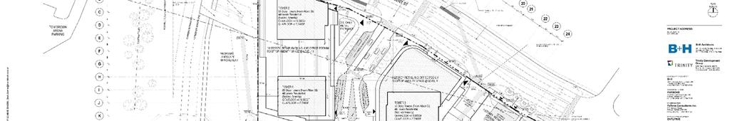
6 Figure : Proposed Site Plan
7 EXISTING CONDITIONS AREA ROAD NETWORK Albert Street is an east-west arterial road that extends from the Mackenzie King Bridge in the east to Bayview Road where it continues as Scott Street. Within the study area, Albert Street has a four-lane cross-section. The posted speed limit within the study area is km/h. Albert Street is currently under construction as part of the Stage I LRT construction project. City Centre Avenue is a north-south local road with a two-lane cross-section, which extends from Albert Street to Spruce Street. On-street parking is permitted along the east and west sides of the roadway. The unposted (default) speed limit of km/h applies to City Centre Avenue. At the southernmost limit of the road, a structure allows pedestrians and cyclists to pass under Somerset Street. Bayview Road is a north-south collector road with a two-lane cross-section, extending from Slidell Street in the north to Somerset Street West, south of the Study Area. The unposted (default) speed limit of km/h applies to Bayview Road. North of the intersection with Albert Street, the Transitway / future LRT corridor crosses over Bayview Road on a structure. PEDESTRIAN/CYCLING NETWORK Sidewalks are currently provided along the north and south side of Albert Street, continuing east beyond the Study Area towards the downtown core of Ottawa, and west across the O-Train Bridge. To prevent mid-block crossings a chain link fence has been erected on the median, forcing pedestrians to use the underpass, also connected to the Bayview O-Train Station. According to the City s Cycling Plan, Albert Street is considered a Spine Route. The existing dedicated bicycle facilities are provided as a Multi-Use Path on the north side of Albert Street that connects to The Champagne - O-Train Corridor Multi- Use Pathway. The Functional Design shown in Appendix C illustrates the proposed East-West Bikeway along Albert Street. The plan features m wide cycle tracks that transition to cycle lanes approaching the Blair Transitway Bridge, and m wide sidewalks or greater are provided on both sides of Albert Street. TRANSIT NETWORK The site is located within m of the Bayview LRT Station. This station is being reconstructed, which will open in. It currently is the northern-most stop for the O-Train Trillium line that runs south from Bayview to Greenboro. Bayview Station is included in the planned Stage Confederation Line that will run from Tunney s Pasture to Blair. Rapid transit service (in the form of BRT) is also provided via Blair Station, which provides convenient access to multiple routes along the Transitway. The following Figure summarizes OC Transpo s Transit network system near the site. Transit service within the vicinity of the site is currently provided by OC Transpo at Stop #6. This includes different routes. Many of these routes were previously along the Transitway, but have been re-routed along the Albert Street Transit Priority lanes for the duration of the LRT construction. Upon completion of Stage of the LRT, many of these routes will be replaced by the LRT. Some will remain along Albert Street but the number and routing of these buses is not known at this time. 9 Albert Street Transportation Impact Study

. The eastbound right-turn movement for vehicles is permitted.")

8 Figure : Area Transit Network EXISTING STUDY AREA INTERSECTIONS Scott Street & Albert Street at Bayview Road The Scott Street & Albert Street intersection at Bayview Road is a signalized four-legged intersection. The eastbound approach consists of a shared through/left-turn lane and a single through lane (transit only - continues as a transit only lane on the east leg of the intersection). The eastbound right-turn movement for vehicles is permitted. The southbound approach consists of a shared through/right-turn lane and an auxiliary left-turn lane. The westbound approach consists of a single through lane, an auxiliary right-turn lane, and an auxiliary left-turn lane. The northbound approach consists of a single through lane with a connecting right-turn channelization in addition to an auxiliary left-turn lane. 9 Albert Street Transportation Impact Study
, a transit only right-turn lane, and an auxiliary left-turn lane.")
9 Albert Street at City Centre Avenue The Albert Street intersection at City Centre Avenue is a signalized four-legged intersection. The north leg is accessed by OC Transpo vehicles only. The westbound approach consists of two through lanes (one lane is a transit only), a transit only right-turn lane, and an auxiliary left-turn lane. The northbound approach consists of a single right-turn lane and an auxiliary leftturn lane. The eastbound approach consists of a single through lane, a transit only through lane that can also be used by vehicles as a right-turn lane, and a transit only auxiliary left-turn lane. EXISTING INTERSECTION OPERATIONS To examine the existing traffic network, turning movement counts were requested from the City of Ottawa. AM and PM peak hour turning movement counts were available, however Saturday data were unavailable. Data collection was undertaken on Saturday October, 6 at both Study Area intersections. The City of Ottawa AM and PM peak hour counts were undertaken in. To account for the difference in the age of counts a background growth rate of.% was applied to the AM and PM peak hour counts to reflect traffic growth between and 6. Additionally, as there are no driveways between Bayview Road and City Centre Avenue along Albert Street, the volume departing one intersection should be equal to the volume arriving at the adjacent intersection. As this was not the case due to fluctuations in daily traffic, the volumes were adjusted to rationalize the imbalances. In all cases where an imbalance existed, the volumes were increased to correct the noted imbalances. Figure illustrates the adjusted AM, PM, and Saturday peak hour volumes at the intersections of Albert Street and Scott Street at Bayview Road and Albert Street at City Centre Avenue. Turning movement count sheets have been included in Appendix D. Figure : Existing Peak Hour Traffic Volumes 9 Albert Street Transportation Impact Study
 ratio and the corresponding Level of Service (LOS) for the critical movement(s).")
 [SAT Peak] Intersection Critical Movement Intersection LOS max. v/c or avg.")
10 Table provides a summary of existing traffic operations at study area intersections based on the SYNCHRO (V9) traffic analysis software. The signalized intersections were assessed in terms of the volume-to-capacity (v/c) ratio and the corresponding Level of Service (LOS) for the critical movement(s). The subject signalized intersection, overall, was assessed based on weighted v/c ratio. The SYNCHRO model output of existing conditions is provided within Appendix E. Table : Existing Performance at Study Area Intersections Weekday AM Peak (PM Peak) [SAT Peak] Intersection Critical Movement Intersection LOS max. v/c or avg. delay (s) Movement Delay (s) LOS v/c Bayview/Scott B(C)[A].6(.)[.] SBL(NBT)[NBT].6(.)[9.] A(A)[A].(.)[.] City Centre/Albert B(A)[A].6(.6)[.] EBT(WBT)[NBL] 6.(.)[9.] A(A)[A].(.)[.] Note: Analysis of signalized intersections assumes a saturation flow rate of veh/h/lane. As shown in Table, the two signalized intersections currently operate overall with an excellent LOS A during all three peak hours. The critical movement is noted to be the northbound through at the Albert Street / Scott Street at Bayview Road intersection, which operates at LOS C or better during all peak hours. Despite this result, it is recognized that the existing traffic volumes and operation along Albert Street is temporary. Albert Street is being used as a bus detour during LRT construction. However, this condition has been accepted as a base case. These findings are consistent with the results of the Tunney s Pasture Master Plan Multi Modal Transportation Study. DEMAND FORECASTING PLANNED STUDY AREA TRANSPORTATION NETWORK CHANGES A notable transportation network change within the study area is the Stage I construction of the east-west LRT, which is the conversion of the City s existing BRT corridor to LRT between the current Blair transit station and the Tunney s Pasture station, which includes a tunnel through the City s Downtown. Currently, this phase of construction is underway and is expected to be completed by. Stage II of the LRT construction, which will extend the City s LRT further east, west, and south (further improving transit within the vicinity of the site), is expected to begin by and be completed by. The following Figure illustrates the planned Stages I and II of the future Confederation/Trillium Lines. As mentioned previously, the subject development is located less than m from the Bayview station. Figure : Planned LRT Stage II 9 Albert Street Transportation Impact Study 6
11 OTHER AREA DEVELOPMENT Through pre-consultation with the City of Ottawa, it was determined that the following development applications which have been submitted in the vicinity of the proposed site, should be considered in this analysis. Tunney s Pasture Tunney s Pasture is located approximately km west of the subject site and currently consists of approximately, office/lab employees. A Master Plan for Tunney s Pasture proposes the site to be redeveloped to consist of approximately, office, lab, and retail employees and approximately, high-density residential dwelling units. The Multi-Modal Transportation Study (prepared by Parsons) projected a net increase in vehicle traffic of, and, veh/h during the morning and afternoon peak hours, respectively. Intersection modifications and new signalized intersections are proposed to address projected deficiencies. Innovation Centre Innovation Centre is located approximately m west of the subject site, north of Albert Street on Bayview Road. This site is currently under renovation. Upon completion, estimated to be in December, 6, the site will accommodate workers in a shared office space. This will include meeting rooms, training rooms, and an auditorium. The site is targeting LEED Gold Certification and will promote sustainable modes of transportation through the provision of 9 indoor bicycle parking spaces, outdoor bicycle parking spaces, and only on-site vehicular parking spaces. No transportation study was available for this site. Zibi The Zibi development is a mixed-use plan that straddles the Ontario-Quebec border. The proposal includes approximately M ft on the Ontario side and M ft on the Quebec side. This development will include a mixture of retail, office, community centre, and residential land uses, in addition a hotel is proposed on the site. The Phase A Transportation Impact Study (prepared by Parsons) projected a net increase in vehicle traffic of and veh/h during the morning and afternoon peak hours, respectively. The traffic assigned to the current study area as a result of the Zibi development is located in Figure 6. Intersection modifications are recommended at locations that are projected to experience capacity issues and a new signalized intersection is proposed for access/egress to/from the development. The projected traffic generated by the directly adjacent developments of the subject site was accounted for as background traffic. The following Figure 6 summarizes the projected new traffic volumes for the above-mentioned developments and their locations with respect to the subject site. 9 Albert Street Transportation Impact Study


12 Figure 6: Local Area Developments The following Figures and illustrate the forecasted and background traffic volumes from the nearby planned developments as well as the additional.% / annum background growth, applied to account for traffic growth outside of the Study Area. Figure : Future Background () Traffic Volumes 9 Albert Street Transportation Impact Study
13 Figure : Future Background () Traffic Volumes The following Table provides a summary of background traffic operations, prior to any development of the proposed site, at study area intersections based on the SYNCHRO (V9) traffic analysis. The detailed SYNCHRO model output of projected background conditions is provided within Appendix F. Table : and Future Background Intersection Operational Analysis Weekday AM Peak (PM Peak) [SAT Peak] Intersection Critical Movement Intersection LOS max. v/c or avg. delay (s) Movement Delay (s) LOS v/c Forecasted Background Growth Bayview/Scott C(C)[B].(.9)[.6] SBL(NBT)[NBT].6(.)[.] B(B)[A].6(.66)[.] City Centre/Albert A(A)[B].(.)[.6] EBT(NBL)[NBL].6(6.)[.] A(A)[A].(.)[.] Forecasted Background Growth Bayview/Scott C(D)[B].(.)[.6] SBL(NBT)[NBT].(.)[.] B(C)[A].(.)[.] City Centre/Albert A(A)[B].(.9)[.6] EBT(NBL)[NBL].(6.6)[.9] A(A)[A].(.9)[.] Note: Analysis of signalized intersections assumes a saturation flow rate of veh/h/lane. As shown in Table, both signalized intersections are projected to continue to operate, overall, at an acceptable LOS B or better in the horizon year. The two critical movements, southbound left (AM peak hour) and northbound left (PM peak hour), are projected to operate above capacity (LOS C). For future background conditions, the Scott Street & Albert Street intersection at Bayview Road is projected to operate at an acceptable LOS C or better during all peak hours, whereas the Albert Street intersection at City Centre Avenue is projected to continue operating at an excellent LOS A. At the Scott Street & Albert Street intersection at Bayview Road, the southbound left and northbound through movements during the morning and afternoon peak hours are considered to be the two critical movements with LOS C and D, respectively. 9 Albert Street Transportation Impact Study 9
14 No mitigation measures are considered since the previously discussed LOS do not exceed the City s permissible operational thresholds (i.e. v/c <.9). Note that the intersections are in separate coordinated signal control areas, and therefore the intersections are coordinated with neighbouring intersections west and east of the corridors, respectively. SITE TRIP GENERATION In order to estimate the impact of the subject development on the road network, it is necessary to estimate the traffic growth associated with the subject developments. Appropriate trip generation rates for the proposed development were obtained from the Ninth Edition of the Institute of Transportation Engineers (ITE) Trip Generation Manual. The trip generation rates and rate equations are summarized in Table. Table : ITE Trip Generation Rates Land Use High-Rise Residential Condominium Data Source ITE General Office Building ITE Shopping Center ITE Notes: T = Average Vehicle Trip Ends X = ft Gross Floor Area du = dwelling units Trip Rates AM Peak PM Peak SAT Peak T =. (du); T =. (du); T =. (du); Ln(T) =. Ln (du) +.6 Ln(T) =. Ln (du) +. T =.9 (du) +.6 T =.6(X); Ln(T) =. Ln(X) +. T =.96(X); Ln(T) =.6 Ln(X) +. T =.9(X); T =.(X) +. T =.(X); Ln(T) =.6 Ln(X) +. T =. (X); N/A T =.; Ln (T) =.6 Ln(x) +. As ITE trip generation surveys only record vehicle trips and typically reflect highly suburban locations (with little to no access by travel modes other than private automobiles), adjustment factors appropriate to the more urban study area context were applied to attain estimates of person trips for the proposed development. This approach is considered appropriate within the industry for urban infill developments. To convert ITE vehicle trip rates to person trips, an auto occupancy factor and a non-auto trip factor were applied to the ITE vehicle trip rates. Our review of available literature suggests that a combined factor of approximately. is considered reasonable to account for typical North American auto occupancy values of approximately. and combined transit and non-motorized modal shares of less than %. Using these factors, along with the rate equations in Table, the person trip generation for the proposed site was calculated. This is summarized in Table. Table : Modified Person Trip Generation Land Use High-Rise Condominium General Office Building Area AM Peak (Person Trips/h) PM Peak (Person Trips/h) SAT Peak (Person Trips/h) In Out Total In Out Total In Out Total,6 du , ft² 6 66 Specialty Retail, ft² ,6 Total Person Trips 96 6, 99,,, 96, Note:. factor to account for typical North American auto occupancy values of approximately. and combined transit and non-motorized modal shares of less than % 9 Albert Street Transportation Impact Study
15 The person trips shown in Table for the proposed site were then reduced by modal share values, including a reduction for pass-by trips and multi-purpose trips for the retail land use based on the site s location and proximity to adjacent communities, employment, other shopping uses, and transit availability. In addition, future transit modal splits are likely to be even greater as the implementation of the City s LRT is completed. High transit mode shares were allocated to the land uses due to the close proximity of the future LRT station in addition to the ease in which it can be accessed. Transit mode shares as high as 6% can be assumed in trip-generation according to the Transit-Oriented Development (TOD) Plan, nonetheless lower values were used to output a worst-case scenario. Modal share, pass-by, and multi-purpose values for condominium, office, and retail land uses within the proposed development for horizon years and are summarized in Tables to 9 with the total site-generated vehicle traffic for both horizon years summarized in Tables and. To account for a gradual shift towards transit use over time, a greater transit mode share was used for the horizon than the horizon. It has been assumed that the shopping centre land use would draw a higher vehicle mode share and is less likely to change over time. The shopping center trips were assumed to have the same mode splits in both horizon years. Tables and 6 summarize the forecasted trip generation for condominium and office land uses for horizon year. Table : Condominium Modal Site Trip Generation - Travel Mode Mode Share AM Peak (Person Trips/hr) PM Peak (Person Trips/hr) SAT Peak (Person Trips/hr) In Out Total In Out Total In Out Total Auto Driver % Auto Passenger % Transit % Non-motorized % 9 6 Total Person Trips % Auto Trips AM Peak (Autos/hr) PM Peak (Autos/hr) SAT Peak (Autos/hr) Total New Residential Condos Auto Trips Table 6: Office Modal Site Trip Generation - Travel Mode Mode Share AM Peak (Person Trips/hr) PM Peak (Person Trips/hr) SAT Peak (Person Trips/hr) In Out Total In Out Total In Out Total Auto Driver % Auto Passenger % 6 9 Transit % Non-motorized % 9 9 Total Person Trips % 6 66 Auto Trips AM Peak (Autos/hr) PM Peak (Autos/hr) SAT Peak (Autos/hr) Total New Office Auto Trips Albert Street Transportation Impact Study
16 Tables and summarize the forecasted trip generation for condominium and office land uses for horizon year. Table : Condominium Modal Site Trip Generation - Travel Mode Mode Share AM Peak (Person Trips/hr) PM Peak (Person Trips/hr) SAT Peak (Person Trips/hr) In Out Total In Out Total In Out Total Auto Driver % Auto Passenger % Transit % Non-motorized % 9 6 Total Person Trips % Auto Trips AM Peak (Autos/hr) PM Peak (Autos/hr) SAT Peak (Autos/hr) Total New Residential Condos Auto Trips Table : Office Modal Site Trip Generation - Travel Mode Mode Share AM Peak (Person Trips/hr) PM Peak (Person Trips/hr) SAT Peak (Person Trips/hr) In Out Total In Out Total In Out Total Auto Driver % Auto Passenger % Transit % Non-motorized % 9 9 Total Person Trips % 6 66 Auto Trips AM Peak (Autos/hr) PM Peak (Autos/hr) SAT Peak (Autos/hr) Total New Office Auto Trips Table 9 summarizes the forecasted trip generation for the shopping centre land uses for both horizon years, and, given that the mode shares are assumed to remain constant. Table 9: Shopping Centre Modal Site Trip Generation / Travel Mode Mode Share AM Peak (Person Trips/hr) PM Peak (Person Trips/hr) SAT Peak (Person Trips/hr) In Out Total In Out Total In Out Total Auto Driver 6% 9 6 Auto Passenger % Transit % 9 Non-motorized % 6 6 Total Person Trips % ,6 Auto Trips AM Peak (Autos/hr) PM Peak (Autos/hr) SAT Peak (Autos/hr) Autos (Mode Share - 6%) 9 6 Less Pass-by (%) Total New Shopping Center Auto Trips Albert Street Transportation Impact Study
17 The following Tables and provides a summary of potential two-way vehicle trips to/from the proposed development for the two horizon years. Table : Total Site Vehicle Trip Generation Travel Mode AM Peak (veh/hr) PM Peak (veh/hr) SAT Peak (veh/hr) In Out Total In Out Total In Out Total Residential Condos General Office Building Shopping Center 9 6 Shopping Center Pass-by (%) Office Multi-Purpose (%) Shopping Center Multi-Purpose (%) Total New Auto Trips Table : Total Site Vehicle Trip Generation Travel Mode AM Peak (veh/hr) PM Peak (veh/hr) SAT Peak (veh/hr) In Out Total In Out Total In Out Total Residential Condos General Office Building Shopping Center 9 6 Shopping Center Pass-by (%) Office Multi-Purpose (%) Shopping Center Multi-Purpose (%) Total New Auto Trips As shown in Table, the forecast new two-way vehicle trip generation for the proposed development is approximately, 6, and 6 veh/h during the weekday morning, afternoon peak hours, and Saturday peak hours, respectively. As shown in Table, the forecast new two-way vehicle trips for the proposed development is approximately,, and 66 veh/h during the weekday morning, afternoon peak hours, and Saturday peak hours, respectively. These numbers have decreased, compared to the horizon, due to the projected changes to the mode share. VEHICLE TRAFFIC DISTRIBUTION AND ASSIGNMENT To determine how the projected traffic would access the site, a trip distribution and assignment exercise has been completed. Several resources were drawn upon to determine a suitable trip distribution for the proposed site, including the NCR Household Origin Destination Survey, the existing east-west volume splits along Albert Street, and local knowledge of the surrounding area. It was determined that due to the mix of land uses and the location of the site, the existing on street volume split would be appropriate indicator of the potential site trip distribution. Figure 9 details the site trip distribution. 9 Albert Street Transportation Impact Study
18 Figure 9: New Site-Generated Traffic Percentage Distribution Based on these distributions, new and pass-by site-generated trips were assigned to study area intersections, which are illustrated as Figures and for horizon years and. Figure : New and Pass-by Site-Generated Traffic Volumes 9 Albert Street Transportation Impact Study
19 Figure : New and Pass-by Site-Generated Traffic Volumes FUTURE TRAFFIC OPERATIONS PROJECTED CONDITIONS AT FULL SITE DEVELOPMENT The total projected volumes associated with the proposed development were derived by superimposing new and pass-by site-generated traffic volumes (Figure and ) onto projected background traffic volumes (Figure and ). The resulting total projected volumes for the horizon years and are illustrated as Figure and, respectively. Figure : Total Projected Peak Hour Traffic Volumes - 9 Albert Street Transportation Impact Study
20 Figure : Total Projected Peak Hour Traffic Volumes - Note that the north leg of the City Centre/Albert intersection is omitted from the projected conditions model due to the limited information currently available in regards to the development/construction planned within the vicinity north of the intersection. Any developments north of the foregoing intersection are assumed to be constructed beyond the horizon years of the proposed 9 Albert development. As such, the removal of the movements to/from the north leg is considered appropriate for the analysis contained in this report. The signal-timing plan for Access (signalized intersection) has been calculated based on the Ontario Traffic Manual (OTM) Book. This proposed signalized intersection is modelled as a coordinated signal only with the adjacent signalized intersection at Albert Street and Scott Street at City Centre due to the proximity of the proposed intersection, approximately m west of the existing intersection. Tables and summarize the projected performance for the study area intersections and site driveway connections for horizon years and, based on total projected traffic volumes. SYNCHRO output sheets for projected conditions are provided in Appendix G. Table : Projected Performance of Study Area Intersections - Weekday AM Peak (PM Peak) [SAT Peak] Intersection Critical Movement Intersection LOS max. v/c or avg. delay (s) Movement Delay (s) LOS v/c Bayview/Scott D(D)[B].(.)[.6] SBL(NBT)[NBT].(.)[.] C(C)[A].(.6)[.] Access /Albert A(D)[C].(.)[.] NBR(NBL)[NBL] 6.6(.)[.9] A(A)[A].6(.)[.] Access /Albert B(A)(B).(9.9)[.] NBR(NBR)[NBR].(.)(.) - - City Centre/Albert A(A)[B].(.)[.6] EBT(NBL)[NBL].(.)[9.] A(A)[A].(.)[.] Note: Analysis of signalized intersections assumes a saturation flow rate of veh/h/lane. 9 Albert Street Transportation Impact Study 6
21 Table : Projected Performance of Study Area Intersections Weekday AM Peak (PM Peak) [SAT Peak] Intersection Critical Movement Intersection LOS max. v/c or avg. delay (s) Movement Delay (s) LOS v/c Bayview/Scott D(D)[B].(.6)[.] SBL(WBT)[NBT].(6.6)[.9] C(D)[A].(.)[.] Access /Albert A(D)[C].(.)[.] NBR(NBL)[NBL] 6.(.)[.] A(A)[A].(.)[.] Access /Albert B(B)(B).(.)(.) NBR(NBR)[NBR].(.)(.) - - City Centre/Albert A(A)[B].(.9)[.66] EBT(NBL)[NBL].(.6)[9.] A(A)[A].(.)[.] Note: Analysis of signalized intersections assumes a saturation flow rate of veh/h/lane. As shown in Table, all Study Area intersections are projected to continue to operate overall at an acceptable LOS C or better in the horizon year. The critical movements are all projected to operate within capacity for the signalized intersections and with minimal delays at the unsignalized intersection. As shown in Table, all Study Area intersections are projected to continue to operate overall at an acceptable LOS D or better in the horizon year. The critical movements are all projected to operate within capacity for the signalized intersections and with minimal delays at the unsignalized intersection. No mitigation measures are considered since the previously discussed LOS do not exceed the City s permissible operational thresholds (i.e. v/c <.9). TRANSPORTATION DEMAND MANAGEMENT Transportation Demand Management (TDM) strategies have the potential to be an integral part of a planned development in order to address and support the City s policies with regard to TDM. For this particular site, the proximity to the Bayview LRT Station is considered very advantageous in lessening the reliance on the private automobile. This was also evident in the analyses conducted for the forecasted conditions. The close proximity of significant employment and residential uses will also contribute to a high pedestrian mode share. The proximity of dedicated on-road cycling facilities will also contribute to maximizing the bicycle mode split. As well, a number of other TDM measures could also be considered to reduce vehicle use, including: Improving the quality and safety of pedestrian facilities, such as enhanced sidewalks/lighting Ride-sharing programs (e.g. community forum where residents can register/arrange carpooling or on-site parking can be reserved for VRTUCAR cars) Carpool incentives (e.g. reserved preferred parking for carpooling residents and carpool drop-off areas) Providing preferential parking for hybrid or electric vehicles Provide an on-site transit information booth to direct visitors and encourage residents to utilize transit Subsidized transit passes Additional shelter area for transit users On-site change room/shower facilities for any on-site staff TDM strategies are important in encouraging active modes of transportation to/from the site, further lessening the reliance on the private automobile. 9 Albert Street Transportation Impact Study
22 SITE PLAN REVIEW This section provides an overview of the site plan from a transportation perspective. The proposed Site Plan was previously illustrated in Figure. Parking To accommodate vehicles on the site, parking spaces will be provided in both above ground and underground parking (no surface lots, only parking within the proposed buildings). Table documents the provided and required parking spaces, broken down by land use. Based on the City of Ottawa s Zoning By-law 6-9, and considering a Transit Oriented Development, the Office portion of the development requires parking stalls. Given the nature, size, and location of the development this minimum would not adequately serve the proposed development. The required number of parking spaces has been developed based on the needs of the proposed land uses and the future tenants requirements. Site Access The proposed development is be accessed by a full movements, signalized intersection and a right in-right out unsignalized access, both onto Albert Street. The primary access point will be the signalized intersection on Albert Street, referred to as Access #. This intersection will provide access to the residential drop-off laybys, upper level parking, and underground parking lots. Ramps are provided to access the upper and lower level parking areas, including a connection through the building to the right in-right out access. The sightlines at Access # have been reviewed and no deficiencies were found. Sightline drawings and calculations are provided in Appendix H. The right in-right out access, referred to as Access #, located east of the Access #, will be primarily for goods movement truck access, through the building, and around to the loading bays, located on the southern side of the building. There will also be a connection to allow vehicles to exit the site from the upper levels via the right in-right access. The sightlines at Access # of the proposed access points have been reviewed and no deficiencies were found. Sightline drawings and calculations are provided in Appendix H. The loading bays at the rear of the building have been reviewed using WB- to ensure that every loading bay can be accessed while the adjacent bays are in use. Additionally, HSU and WB- turning templates have been reviewed for the access points as well as the loading bays. All curbs have been designed to permit access by both design vehicles. To ensure that HSU vehicles would be able to exit the site if they turned into the main site access a turning template simulation was undertaken showing an HSU using the ramp down to P and existing at Access #. Appendix I contains figures including the AutoTurn simulations. Transit As noted previously the proposed development is directly adjacent to Bayview Station. Bayview Station will become the future Bayview LRT Station, and will serve as the connecting station between the east-west Confederation Line and the north-south Trillium Line. The proposed development will connect directly to the station through a walkway directly from the main level of the shopping centre to the Bayview Station platform. Additionally, the sidewalks along the frontage will include a staircase down from the road level to the platform. While the LRT will provide citywide transit connectivity, transit service will remain on Albert Street, serving the site with nearside bus stops at the main signalized access intersection. It is not known at this time how frequently, or what routes, will service the bus stops on Albert Street. This will be determined by OC Transpo at the appropriate time. Appendix A contains the Multi-Modal Level of Service, detailing the interaction between transit, pedestrian, cycling, and vehicle LOS. Roadway Modification Approval drawings are included as Appendix B, detailing the location of the nearside bus stops along Albert Street. 9 Albert Street Transportation Impact Study
23 Pedestrians Given the location of the site and the nature of Transit Oriented Developments, the focus is about moving pedestrians to and from the nearby Transit Station. As discussed previously the proposed site will integrate with and connect to the future LRT Station with excellent pedestrian connectivity. Additionally, the site will provide high quality pedestrian facilities within the site and along the frontage of Albert Street. A wide sidewalk will be provided along both sides of the internal access road with a crosswalk at the narrowest point to allow access to the proposed storefronts. Additionally, sidewalks will be provided along both sides of Albert Street along the frontage of the site to provide connections across the Trillium Line and to the east towards central core of downtown Ottawa. Appendix A contains the Multi-Modal Level of Service, detailing the interaction between transit, pedestrian, cycling, and vehicle LOS. Bicycles As shown in the Function Plan for Albert Street, along the frontage of 9 Albert Street, cycle tracks are proposed eastbound and westbound along Albert Street. This Spine Route will provide connectivity between the proposed development and the core of Ottawa s downtown area. Additionally, cross-rides are provided in all directions at Access # to facilitate cyclists crossing at the intersection in a safe manner. Appendix A contains the Multi-Modal Level of Service, detailing the interaction between transit, pedestrian, cycling, and vehicle LOS. To accommodate bicycle parking, a large section of the first underground parking level, P, is dedicated to secure, indoor bicycle storage. This area includes 66 bicycle parking spaces, and is accessible through an exterior door in the northeast corner of the building, approximately at the level of the Bayview LRT platform, and by a stairwell located under the northeast tower (tower ). Additionally, 6 bicycle parking spaces are provided outside of the building. The proposed 99 bicycle parking spaces meet the zoning by-law requirements for all three land uses. FINDINGS AND RECOMMENDATIONS Based on the foregoing analysis of the proposed development, the following transportation-related conclusions are offered: The existing signalized intersections of City Centre Avenue at Albert Street and Bayview Road at Albert Street are currently operating overall LOS A and with no critical movements (i.e. LOS E or worse) during the weekday morning, weekday afternoon, and Saturday midday peak hours. Background traffic due to study area developments has been accounted for in projected conditions using traffic volumes from corresponding Transportation Impact Assessments as well as a.% background growth rate to reflect traffic growth from sources outside of the study area. The intersection operational analysis of the intersections, including the additional traffic to account for background growth, project that the study area intersections operate with good overall LOS, LOS C or better in all peak hours examined, and with no critical movements. As the proposed development is a TOD, a high transit mode share was used to estimate the trip generation of the subject site. Different mode shares were applied to each projected horizon to anticipate the growing popularity of transit. Additionally, to account for the varied land uses on the site a different mode share was used for the retail / commercial portion of the development. Using the aforementioned mode share assumptions along with ITE Trip Generation Manual Rates the subject site is projected, for the horizon, to generate, 6, and 6 veh/h during the weekday morning, afternoon peak hours, and Saturday s peak hour, respectively. 9 Albert Street Transportation Impact Study 9


24 Using the aforementioned mode share assumptions along with ITE Trip Generation Manual Rates the subject site is projected, for the horizon,, and 66 veh/h during the weekday morning, afternoon peak hours, and Saturday s peak hour, respectively. The overall LOS at each existing intersection is projected to continue to operate with LOS D or better in all three examined peak hours. The new site accesses were examined using appropriate lane geometry and, at the signalized intersection, a standard timing plan. Using the foregoing assumptions, the new site intersections were shown to operate with good overall LOS and no critical movements for all three studied peak hours. The proposed site plan provides adequate parking to serve the future tenants and residents of 9 Albert Street. Based on the nature, size, and location of the development the zoning by-law minimum parking provisions would not adequately serve the proposed development. The proposed site plan provides adequate bicycle parking to serve the future residents of 9 Albert Street. The site requires 99 bicycle parking spaces. The proposed site plan accommodates the majority of the bicycle parking on the first underground level of parking, 66 indoor, secure, bicycle parking spaces. Sixty-three additional bicycle parking spaces are provided above ground for the use of customers / visitors to the site. Based on discussions and meetings with the City of Ottawa Planning and Transportation Staff, the configuration of Albert Street along the frontage of 9 Albert Street reflects the best design to accommodate all needs, with active modes and transit receiving the highest priority. The MMLOS analysis and resulting RMA for Albert Street are appended to this TIS. Based on the foregoing, the proposed development fits well into the context of the surrounding area, and its location and design serves to promote use of walking, cycling, and transit modes, thus supporting City of Ottawa policies, goals, and objectives with respect to redevelopment, intensification, and modal share. Therefore, the proposed 9 Albert Street mixed-use development is recommended from a transportation perspective. Prepared By: Reviewed By: Mark Crockford, P. Eng. Transportation Engineer 9-Nov-6 Christopher Gordon, P.Eng. Senior Project Manager 9-Nov-6 9 Albert Street Transportation Impact Study
25 Appendix A Multi-Modal Level of Service (MMLOS)
 of all users, including pedestrians, cyclists, transit riders, and vehicles")
26 Technical Memorandum To: Mark Crockford, Chris Gordon Copy: Andre Sponder, Andrew Harte From: Amer Al-Merabi Re: 9 Albert Street MMLOS Analysis Date: Project: 9 November MMLOS ANALYSIS PERFORMANCE IMPLICATIONS Throughout the planning of 9 Albert, care has be taken when assessing the level-of-service (LOS) of all users, including pedestrians, cyclists, transit riders, and vehicles (autos and trucks). As of October, the City of Ottawa has adopted a Multi-Modal Level of Service (MMLOS) analysis tool that evaluates the foregoing modes of travel. The MMLOS Guidelines account for LoS of road segments (mid-block) and at signalized intersections, with the exception of vehicle LOS, which is solely analyzed at signalized intersections. To ensure the 9 Albert development meets the desired MMLOS, the City s analysis tool has been applied to the segment of Albert Street that fronts the site. For the purpose of the ensuing analysis, the road segment MMLOS will primarily focus on the following two segments: Segment : Located approximately m west of the proposed signalized Albert/Site intersection Segment : Between the proposed signalized Albert/Site intersection and the City Centre/Albert intersection The terms Segment and Segment will be used throughout this report when discussing the analysis of road segments for each travel mode. With regard to the intersection MMLOS analysis, only the proposed signalized Albert/Site intersection will be evaluated. Figure depicts the proposed lane configurations for site s driveway connection. Figure : 9 Albert Signalized Driveway Connection - Proposed Intersection Lane Configuration

, as mentioned in the MMLOS guidelines, is a tool that allows designers and planners to evaluate the pedestrian level of comfort, safety, and")
27 An integral variable that influences the MMLoS analysis is the vehicle operating speed ( th percentile) along the corridor within the current study area. As such, Parsons requested a spot speed survey, which was completed on October th, 6. The spot speed survey is attached to this document. The th percentile speed was equal to 6 km/h across a corridor with is posted speed of km/h. PEDESTRIAN PLOS The Pedestrian Level of Service (PLOS), as mentioned in the MMLOS guidelines, is a tool that allows designers and planners to evaluate the pedestrian level of comfort, safety, and convenience. The following two sections describe the process behind the road segment and signalized intersection MMLOS analysis for pedestrians. The City of Ottawa s MMLOS guidelines will only categorize and rate the level-of-service of both the road segment and signalized intersection based on items present within the right-of-way (ROW). However, additional pedestrian facilities can be implemented outside the ROW, which include the addition of pedestrian signage and an on-site raised bridge connecting to Bayview Station. The following road segment and signalized intersection analysis will output several pedestrian levels of service, which represent the worst-case scenarios and do not include the foregoing on-site facilities. The proposed development is within 6 m of a rapid transit station; therefore, the target level of service for pedestrians at mid-blocks (road segments) and at intersections is PLOS A. ROAD SEGMENT ANALYSIS As mentioned previously, the road segment analysis was evaluated along two adjacent segments west and east of the proposed 9 Albert signalized intersection. The operating speed along both segments is 6 km/h. Annual Average Daily Traffic (AADT) at the west leg of the City Centre/Albert intersection is, veh/day. Lastly, the proposed Site Plan includes a. m sidewalk, which is similar to what exists today, and a. m cycling track with a. m buffer. As such, the PLoS across both road segments is PLOS D, as shown in Table (excerpt from MMLOS guidelines). Table : Projected PLoS Roadways Segments SIGNALIZED INTERSECTION ANALYSIS Pedestrian Level of Service is evaluated at intersections using the Pedestrian Exposure to Traffic at Signalized Intersections (PETSI) evaluating tool as well as applying a Delay Score evaluation. The PETSI evaluation takes into account the crossing distance, conditions of crossing, types of conflicts, corner radii, and crosswalk markings. The Delay 9 Albert Street - MMLoS Analysis

28 Score evaluation scores the intersection based on the average wait time for pedestrians to cross the roadway. Note that this intersection is not constructed yet and as such a signal timing plan was calculated based on the proposed geometry. Table provides the required PETSI and delay analysis for the subject intersection. As indicated in Table, the overall PLOS for the proposed Albert/Site intersection is LOS E. Table : Projected PLoS Intersection Evaluation Proposed 9 Albert Intersection 9 Albert Street - MMLoS Analysis

 and at intersections is BLOS A.")
29 CYCLISTS BLOS Bicycle Level of Service (BLOS) is analyzed based on the level of traffic stress (LTS) that is experienced by cyclists along the corridor. Road segment and signalized intersection MMLOS analysis for cyclists depend mainly on the type of bikeway facilities provided, number of lanes, and motorist operating speeds. The following two sections give a brief description of the process. Given the corridor being analyzed is designated as a Cross-Town Bikeway, the Target level of service for cyclists at midblocks (road segments) and at intersections is BLOS A. ROAD SEGMENT ANALYSIS The road segment BLOS is based on the type of physical separation for the bikeways. The type of facilities provided such as curbs, raised medians, and parking lanes may enhance the BLOS. Other variables that affect the BLOS are the number of travel lanes, bike lane width, and operating speed. For Segments and, the number of travel lanes differ, the bike lane widths are. m, and the current operating speed is 6 km/h. Along Segments and, the current Site Plan depicts cycle tracks with no physical separation along the bridge segment in the eastbound and westbound directions. Given the information listed above, the BLOS for Segments and is an excellent BLOS A which satisfies the target BLOS. Table, an excerpt from the MMLOS guidelines (Exhibit ), illustrates the various category for BLOS when bike lanes are allocated along a segment. Table : Projected BLoS Roadway Segments (Segments & ) SIGNALIZED INTERSECTION ANALYSIS With regard to signalized intersection analysis, each approach may have a different level of service depending on several factors. The presence of bike lanes, number of lanes to be crossed by left-turning cyclists, operating speed of adjacent traffic are all variables that are used to assign a BLoS at a signalized intersection. The LTS for cyclists performing a rightturn at signalized intersection with bike lanes or higher order facilities is not impacted. As such, the following analysis will only highlight the requirements for cyclists making left-turn movements. Table, an excerpt from the MMLoS Guidelines (Exhibit ), provides the necessary evaluation for BLOS at signalized intersections. Table : Projected BLOS Signalized Albert/Site Intersection The south leg consists of a left-turn lane and a right-turn lane with an operating speed assumed less than km/h given the limited space available for cars to gain speed as they egress the site. In such a lane configuration, cyclists making a northbound left-turn movement can do so using the two-stage crossing configuration and therefore the cyclist level of service is an excellent BLOS A which meets the target BLOS. 9 Albert Street - MMLoS Analysis

, as mentioned by the MMLOS guidelines, is a tool used to assess this")
30 With regard to the east leg, cyclists making a westbound left-turn continue along the cycling track reaching the west leg and then wait for the northbound phase in order to cross south. A two-stage left-turn scores an excellent BLOS A which meets the target BLOS. Even though the current design for cyclist crossing is not present in Table, it is evident that the design increases cyclist safety and reduces the levels of stress. TRANSIT TLOS As the City of Ottawa tries to increase the relative attractiveness of transit, the Transit Level of Service (TLOS), as mentioned by the MMLOS guidelines, is a tool used to assess this mode of transportation. The following two sections describe how TLOS is analyzed along road segments and at signalized intersections. The Target level of service for transit at mid-blocks (road segments) and at intersections is LOS A. Although the LRT will be operational prior to the full occupancy, bus transit will still remain operating along the corridor. The number of buses in operation along the corridor and may decrease with time depending on the success of the LRT and operational needs/demands for local service. Figure shows the existing Trillium Line and the future Confederation Line that will be operational in. Figure : LRT - Stage II ROAD SEGMENT ANALYSIS Local bus stops are provided near side of the site s proposed signalized intersection at Albert Street. Although bus stops are present, this does not have an impact on the road segment TLOS according to the MMLOS guidelines. The integral variable that dictates the TLOS is the facility type Bus lane vs. Mixed Traffic. Since no bus lanes are implemented along the Albert Street segments within our study area, the level of service is limited between TLOS D and F. Table, an excerpt from the MMLOS guidelines (Exhibit ), provides the necessary evaluation for TLOS across roadway segments. The road segment TLOS across Segments and is TLOS E given that medium driveway friction is assumed. Table : Projected TLoS Roadway Segments (Segments & ) 9 Albert Street - MMLoS Analysis


31 Current MMLOS guidelines do not take into account the presence of LRT, nevertheless having such a mode of transportation at a close proximity to the proposed site promotes the use of transit for residents, employees, and retail customers within the vicinity of the study area. As such, based on engineering judgment and understanding the theory used to assign LOS designations, the proposed corridor segments may score an excellent TLOS A thus meeting the target TLOS. SIGNALIZED INTERSECTION ANALYSIS Local bus stops are proposed near side of the 9 Albert proposed signalized intersection. This increases the level of comfort of transit users and as such enhances the transit level of service. Note that this is not reflected in the MMLOS guidelines. The TLOS at signalized intersections is based on average signal delay and the type of transit priority designation. Table 6, an excerpt from the MMLOS guidelines (Exhibit 6), provides the necessary evaluation for TLOS at signalized intersections. Using SYNCHRO (V9) traffic analysis software, vehicle delay was calculated to equal less than seconds, which results in a TLOS C which does not meet the target TLOS. Table 6: Projected TLOS Signalized Albert/Site Intersection Although the target the TLOS is not met, one should note that a LRT will be operating besides the site and as such will enhance the transit level of service. The future LRT will be located adjacent to the roadway and does not have any mutual signal coordination with existing vehicular traffic signals. As such, vehicles have zero impact on the LRT delay, which results in an excellent projected TLOS A that meets the target TLOS. TRUCK TKLOS Albert Street is a designated Truck Route as illustrated in the City of Ottawa s Urban Truck Route Map. The City of Ottawa characterizes the Truck Level of Service (TKLOS) as an evaluation to facilitate the movement of goods within the city. The evaluation considers street width, curb lane width, effective radii, and number of receiving lanes on departing leg. The following two sections describe how TKLOS is analyzed along road segments and at signalized intersections. The Target level of service for trucks at mid-blocks (road segments) and at intersections is LOS D. ROAD SEGMENT ANALYSIS The road segment TKLOS is based on the curb lane width and the total number of travel lanes (both directions). Table, an excerpt from the MMLOS guidelines (Exhibit ), illustrates the projected road segment TKLOS. Both segments are proposed to have more than two travel lanes (in both directions) with a curb lane width of. m and as such both segments receive an TKLOS A. Table : Projected TKLOS Roadway Segments and 9 Albert Street - MMLoS Analysis 6

32 SIGNALIZED INTERSECTION ANALYSIS The signalized intersection TKLOS is based on the effective corner radius and the number of receiving lanes that take the departure vehicle traffic. TKLOS is used to analyze the eastbound right-turn and northbound right-turn movements. Given that the south-west and south-east quadrants have corner radii within the m to m range, Table, an excerpt from the MMLOS guidelines (Exhibit ), illustrates the projected signalized intersection TKLOS. Note that the TKLOS for the west and south legs are different since the number of right-turn movement receiving lanes are different. The south leg has one receiving lane for the corresponding eastbound right-turn movement and therefore is a TKLOS F, which does not meet the target LoS. The east leg has two receiving lanes for the corresponding northbound right-turn movement and therefore is a TKLOS D, which coincides with the target LoS. Table : Projected TKLOS Signalized Intersection VEHICLE LEVEL OF SERVICE Existing Vehicle Level of Service (LOS) is provided as Table 9. The SYNCHRO model output of existing conditions is provided within Appendix E. Analysis of the projected conditions was conducted using SYNCHRO (V9), a traffic analysis software. The subject signalized intersections were assessed in terms of the volume-to-capacity (v/c) ratio and the corresponding Level of Service (LOS) for the critical movement(s). The subject signalized intersections as a whole were assessed based on weighted v/c ratio. Table provides the projected vehicle LOS given the forecasted model shares, background growth, and new trips generated by the 9 Albert development. The SYNCHRO model output of projected conditions is provided as Appendix G. The governing projected level of service in, overall, at Albert Street and Scott Street at Bayview Road and Albert Street at City Centre Avenue are LOS D (during PM peak hour) and LOS A (during all peak hours), respectively. Therefore, the target LOS is satisfied. Table 9: Existing Performance at Study Area Intersections Weekday AM Peak (PM Peak) [SAT Peak] Intersection Critical Movement Intersection LOS max. v/c or avg. delay (s) Movement Delay (s) LOS v/c Bayview/Scott B(C)[A].6(.)[.] SBL(NBT)[NBT].6(.)[9.] A(A)[A].(.)[.] City Centre/Albert B(A)[A].6(.6)[.] EBT(WBT)[NBL] 6.(.)[9.] A(A)[A].(.)[.] Note: Analysis of signalized intersections assumes a saturation flow rate of veh/h/lane. Table : Projected Performance of Study Area Intersections Weekday AM Peak (PM Peak) [SAT Peak] Intersection LOS Critical Movement max. v/c or avg. delay (s) Intersection Movement Delay (s) LOS v/c Bayview/Scott D(D)[B].(.6)[.] SBL(WBT)[NBT].(6.6)[.9] C(D)[A].(.)[.] Access /Albert A(D)[C].(.)[.] NBR(NBL)[NBL] 6.(.)[.] A(A)[A].(.)[.] Access /Albert B(B)(B).(.)(.) NBR(NBR)[NBR].(.)(.) - - City Centre/Albert A(A)[B].(.9)[.66] EBT(NBL)[NBL].(.6)[9.] A(A)[A].(.)[.] Note: Analysis of signalized intersections assumes a saturation flow rate of veh/h/lane. 9 Albert Street - MMLoS Analysis
33 SUMMARY OF INTERSECTION AND ROAD SEGMENT MMLOS Table summarizes the findings of intersection and road segment MMLOS along the corridor north of the proposed site. Projected conditions and corresponding LOS are subject to change depending on any modifications to the proposed signalized intersection design and roadway geometry. Table : MMLOS Summary All Modes MODE ELEMENT EVALUATION PROJECTED CONDITIONS PLoS BLoS TLoS Segment Intersection Segment Intersection Level of comfort Exposure to traffic Delay Level of comfort Level of Stress/ Risk On-street parking prohibited High AADT volume (, veh/day) Zebra strip hi-vis markings Small corner radii travel lanes separated by raised median m wide bike lanes 6 km/h operating speed Two-stage crossing PROJECTED LOS Segment Level of reliability Reduced E A Intersection Delay <s Using SYNCHRO V9 C A Segment Level of comfort. m curb lane width A D More than two travel lanes (two-way) TKLoS Competing Modes Corner radius < m Intersection Level of Risk F D One receiving lane in the south leg VLoS Intersection Lane utilization D () A () E Note: ) LOS at Albert Street and Scott Street at Bayview Road ) LOS at Albert Street at City Centre D E A A TARGET LOS A A A A CONTEXT The MMLOS analysis provided herein illustrates the many positive features of the proposed development. Although projected pedestrian level of services have not met the target LOS according to the MMLOS guidelines, several mitigation measures will be implemented that will increase the level of comfort and reduce the stress level of pedestrians. Additional pedestrian signage and a pedestrian on-site raised bridge connecting to Bayview Station are not awarded points in the guidelines simply because they are not featured in the MMLOS guidelines. Therefore, one may state that the level of services obtained for pedestrians is not reflective of the proposed development. Additionally, the same can be stated regarding the projected transit level of service. As mentioned previously, the site is located within m of the Bayview LRT Station. The City of Ottawa is investing in the LRT project and thus it is evident that the transit level of service is much higher than the awarded TLOS based on current MMLOS guidelines. Based on the foregoing, it is reasonable to assume that the transit level of service is higher than TLOS E and C for the segment and intersection analysis, respectively. Furthermore, projected truck level of service at the intersection may be achieving a lower LOS but given the limited ROW across the corridor, the unsignalized intersection is constrained to one receiving lane. Although the turning movement is assessed, as long as only one receiving lane is present, the LOS will not increase unless the corner radii increase which will negatively affect other travel modes. To conclude, despite some of the MMLOS results, the 9 Albert development offers many features that benefit pedestrians, cyclists, and transit users. 9 Albert Street - MMLoS Analysis
34 Appendix B Roadway Modification Approval (RMA) Submission
35 PROPOSED CONCRETE SIDEWALK (TYP.) PROPOSED BIKE TRACK (TYP.) PROPOSED GRASS BOULEVARD (TYP.) PROPOSED CONCRETE MEDIAN (TYP.) PROPOSED BUS STOP Limit of Study Albert Street Limit of Study PROPOSED BUS STOP Limit of Study Limit of Study City Centre Avenue LEGEND: PROPOSED DEVELOPMENT PROPOSED ASPHALT AND DEPRESSED CURB PROPOSED SIDEWALK AND CONCRETE MEDIAN PROPOSED GRASS BOULEVARD PROPOSED ROADWAY MODIFICATIONS Approved By: Completed By: PARSONS Scale: TRANSPORTATION ENGINEERING SERVICES N.T.S. - Date: Nov. 6 Drawing No.: TES-6-
36 LEGEND: PROPOSED ROADWAY MODIFICATIONS PROPOSED DEVELOPMENT TRANSPORTATION SERVICES DEPARTMENT PROPOSED ROADWAY MODIFICATIONS Approved By: Completed By: PARSONS Scale: TRANSPORTATION ENGINEERING SERVICES N.T.S. - Date: Nov. 6 Drawing No.: TES-6-
37 Project Name: Subject: Date: Job #: 9 Albert Steet Development RMA Class 'D' Cost Estimate //6 6- WBS Description Cost. Removals $,9.. New Construction $ 6,9.. Traffic Signals $,.. Streetlighting $,. Subtotal $,6,. Property Utilities Engineering Internal City Costs Miscellaneous % % % % % $ $ $ $ $ -,6.,6.,6. - Subtotal $,,. Contingency % $ 969,. Grand Total $,9,9.9 Notes: Landscaping elements have not been included in this costing exercise. No property impacts are noted beyond the dedication of the Albert Street right-of-way. Linear infrastructure/servicing infrastructure has not been included in this costing exercise. Pavement structure to be confirmed by geotechnical recommendations Traffic Signal and Street-lighting costs based on recent project costing and will be subject to change once the City of Ottawa has completed the design and costing for each. 6 Utility impacts have not been explicitly costed and standard City contingency rates have been applied. \\XCCANFS\Data\ISO\6\\DATA\6..9Albert.RMA.costing.6.xlsx Summary
38 Project Name: Subject: Date: Job #: 9 Albert Steet Development RMA Class 'D' Cost Estimate //6 6- Item Code Units City Cost Quantity Cost. Removals Remove asphalt pavement - full depth L. m $.. $,. Remove asphalt pavement - partial depth (planing) D. m $. 9. $ 69. Removal of concrete sidewalk L. m $.. $,. Removal of sign and post (parking signage) - ea $.. $. Relocate existing catchbasin F. ea $,.. $,. Removal and salvage of existing traffic plant L. LS $,6.. $,. Relocate street lighting/utility poles - EA $,.. $,. Removal of concrete median L. m $ $,. Excavation L. m $.. $,. Hydro excavation/vacuum truck (operated) U. hr $.. $,. Removals - Subtotal $,9.. New Construction Traffic control plan A. LS $,.. $,. Police assistance at intersection A. hr $.. $,. Erosion and sediment control A. LS $,.. $,. Superpave.mm level B (PG -) (mm) L. t $.. $ 9,6. Superpave 9mm level B (PG -) (mm) L9. t $.. $,6. Granular 'A' (mm) L. t $. 69. $,9. Granular 'B' (mm) L. t $. 66. $,. Concrete curb SC. N. m $ 6.. $,. Concrete sidewalks, boulevards and islands L.6 m $.. $,96. Monolithic concrete sidewalks, boulevards and islands L. m $ 6.. $,. Topsoil (mm) N. m $ 6.. $,. Sod, Water Included N. m $.. $,. Supply curb inlet 'Fish' type frame and cover N. ea $.. $,9. Supply surface inlet catchbasin with "Fish" type round cover N.6 ea $ 6.. $,. Catchbasinlead PVC mm SDR F6. m $.. $,6. Supply Standard Valve chamber cover, plug and frame N.9 ea $.. $. Adjusting or rebuilding curb inlet, catchbasin L6. ea $ 99.. $,9. Adjusting or rebuilding maintenance holes andvalve chambers L6. ea $ $,96. Adjust or rebuild manholes W. ea $.. $,96. Pavement marking - line - m $.. $,. Pavement marking - symbol - ea $.. $,. Asphalt sidewalk L. m $.. $,. TWSI L. m $,.. $,. Bus Pad ea $,.. $,. Signs - ea $.. $,. Flex Posts - ea $.. $,. Granular 'A' bedding - sidewalk (mm) D. t $..6 $,9. New Construction - Subtotal $ 6,9.. Traffic Signals City design fees - LS $,.. $,. Traffic signals construction - LS $,. 6. $,. Traffic signals - subtotal $,.. Streetlighting City design fees - LS $,.. $,. Street lighting third party construction services - LS $,.. $,. Streetlighting construction - Ea $,.. $,. Streetlighting - Subtotal $,. \\XCCANFS\Data\ISO\6\\DATA\6..9Albert.RMA.costing.6.xlsx Quantities
39 Appendix C 9 Albert Street - Functional Design Plan
40 Drawing Frame: 9mm x mm City of Ottawa (Rev.) Page Setup: Albert Street Development 9 Albert Street Functional Plan Des. Dwn. Dwg. No. 6 Sheet of 6 Chk'd. Chk'd. MJM Scale: HORIZONTAL m NOTE: The location of utilities is approximate only, the exact location should be determined by consulting the municipal authorities and utility companies concerned. The contractor shall prove the location of utilities and shall be responsible for adequate protection from damage. No. Description By Date (dd/mm/yy) Conceptual Design Plan MJM //6 Bayview Station Limit of Study Albert Street Limit of Study Limit of Study SITE Limit of Study City Centre Avenue \\xccanfs\data\iso\6\\dwgs\9 Albert St --6 RMA V.dwg REVISIONS Consultant's Information: Wednesday, November 9, 6 :: AM Wednesday, November 9, 6 :: AM Last Saved: Plot Date:
41 Drawing Frame: 9mm x mm City of Ottawa (Rev.) Page Setup: ---- Note All markings have thickness of cm unless otherwise stated 9 Albert Street Development 9 Albert Street Pavement Marking and Signage Des. Dwn. Dwg. No. 6 6 Sheet 6 of 6 Chk'd. Chk'd. MJM Bayview Station... m-yellow SOLID Rb- (OTM) Wa-L (OTM) Limit of Study Flex Post (TYP.) Flex Post (TYP.) Rb- (OTM) Wa-R (OTM) Limit of Study Wc-L (TAC) Bus Stop As Per SC. Rb-9 (TAC) Rb-t (OTM) Rb- (OTM) Wa-L (OTM) m-white DASHED (-6) m-white DASHED (-6) Wc- (OTM) Wc-t (OTM) (.m-.m) ELEPHANT TRACK (TYP.).... Wc- (OTM) Wc-t (OTM) Wb- (TAC) Rb- (OTM) Wa-L (OTM).. m CHICKEN SCRATCH m CHICKEN SCRATCH m CHICKEN SCRATCH m CHICKEN SCRATCH..... m-white DASHED (-6) m-white SOLID m-white DASHED (-6) m-white DASHED (-) Wc-L (TAC) CONCRETE SIDEWALK CONTINUES TO BUILDING EDGE SITE Bus Stop As Per SC. TWSI (TYP.) Albert Street m-white SOLID... m-white DASHED (-) Wc- (OTM) Wc-t (OTM) m-white DASHED (-) Rb- (OTM) Wa-L (OTM) m-white DASHED (-) Rb- (OTM) Rb-6 (OTM) Wc- (OTM) Wc-t (OTM) Rb- (OTM) m-white SOLID Limit of Study m-white SOLID Limit of Study NOTE: No. The location of utilities is approximate only, the exact location should be determined by consulting the municipal authorities and utility companies concerned. The contractor shall prove the location of utilities and shall be responsible for adequate protection from damage. (6cm) BAR (TYP.) City Centre Avenue Description By Date (dd/mm/yy) \\xccanfs\data\iso\6\\dwgs\9 Albert St --6 RMA V.dwg REVISIONS Consultant's Information: Last Saved: Wednesday, November 9, 6 :: AM Plot Date: Wednesday, November 9, 6 :: AM Scale: HORIZONTAL m Conceptual Design Plan MJM //6
42 Appendix D Turning Movement Count Sheets
43 Public Works - Traffic Services Turning Movement Count - Full Study Diagram BAYVIEW SCOTT ST/ALBERT ST Survey Date: Tuesday, April, WO#: 9 Device: Miovision BAYVIEW RD N W E 9 6 S Total Heavy Vehicles Cars SCOTT ST/ALBERT ST Cars Heavy Vehicles Total 6 9 Comments 6-Sep- Page of
44 Public Works - Traffic Services Turning Movement Count - Peak Hour Diagram BAYVIEW SCOTT ST/ALBERT ST Survey Date: Start Time: Tuesday, April, WO No: 9 : Device: Miovision BAYVIEW RD N W E 6 S Heavy Vehicles Cars 6 SCOTT ST/ALBERT ST AM Period Peak Hour : 9: Cars Heavy Vehicles Total 6 Comments 6-Sep- Page of
45 Public Works - Traffic Services Turning Movement Count - Peak Hour Diagram BAYVIEW SCOTT ST/ALBERT ST Survey Date: Start Time: Tuesday, April, WO No: 9 : Device: Miovision BAYVIEW RD N W E S Heavy Vehicles Cars 6 6 SCOTT ST/ALBERT ST Full Study Peak Hour : : Cars Heavy Vehicles Total Comments 6-Sep- Page of
46 Public Works - Traffic Services Turning Movement Count - Peak Hour Diagram BAYVIEW SCOTT ST/ALBERT ST Survey Date: Start Time: Tuesday, April, WO No: 9 : Device: Miovision BAYVIEW RD N W E S Heavy Vehicles Cars SCOTT ST/ALBERT ST MD Period Peak Hour : : Cars Heavy Vehicles Total 9 Comments 6-Sep- Page of
47 Public Works - Traffic Services Turning Movement Count - Peak Hour Diagram BAYVIEW SCOTT ST/ALBERT ST Survey Date: Start Time: Tuesday, April, WO No: 9 : Device: Miovision BAYVIEW RD N W E S Heavy Vehicles Cars 6 6 SCOTT ST/ALBERT ST PM Period Peak Hour : : Cars Heavy Vehicles Total Comments 6-Sep- Page of
48 Survey Date: : Period : LT 9 Public Works - Traffic Services Turning Movement Count - Full Study Summary Report Tuesday, April, Northbound ST RT BAYVIEW SCOTT ST/ALBERT ST BAYVIEW RD NB TOT LT Southbound ST RT Northbound: Eastbound: SB TOT Total Observed U-Turns Full Study STR TOT Southbound:.9 Westbound: LT Eastbound ST SCOTT ST/ALBERT ST RT EB TOT LT Westbound ST RT Work Order 9 AADT Factor WB TOT STR TOT Grand Total : 9: : : : : : : : 6: : : : : Sub Total U Turns Total EQ Hr Note: These values are calculated by multiplying the totals by the appropriate expansion factor AVG Hr Note: These volumes are calculated by multiplying the Equivalent hr. totals by the AADT factor AVG Hr Note: These volumes are calculated by multiplying the Average Daily hr. totals by to expansion factor Comments: Note: U-Turns provided for approach totals. Refer to 'U-Turn' Report for specific breakdown. 6-Sep- Page of
49 Turning Movement Count - Minute Summary Report Survey Date: BAYVIEW SCOTT ST/ALBERT ST Tuesday, April, 9 Total Observed U-Turns Northbound: Eastbound: Southbound: Westbound: Public Works - Traffic Services W.O. Grand Total STR TOT W TOT RT ST LT E TOT RT ST LT STR TOT S TOT RT ST LT N TOT RT ST LT Time Period Northbound Southbound Eastbound Westbound BAYVIEW RD SCOTT ST/ALBERT ST : : : : : : 6 66 : : : : 6 9 : : : : : : 9 9 9: 9: : 9: : 9: : 9: : : : : 9 9 : : : : : : : : : : : : : : : : : : 6 9 6: : : 6: : 6: : 6: : 6: 9 : : : : : : 6 : : Comment: Note: U-Turns are included in Totals TOTAL: Page of 6-Sep-
50 Public Works - Traffic Services Turning Movement Count - Pedestrian Volume Report Work Order 9 Count Date: BAYVIEW SCOTT ST/ALBERT ST Tuesday, April, Start Time: : Time Period NB Approach (E or W Crossing) SB Approach (E or W Crossing) Total EB Approach (N or S Crossing) WB Approach (N or S Crossing) Total Grand Total : : : : : : : : : : 9: 9: 9: 9: 9: : : : : : : : : : : : : : : : 6: 6: 6: 6: 6: : : : : : Total : : : : : : : : 9: 9: 9: 9: 9: : : : : : : : : : : : : : : : 6: 6: 6: 6: 6: : : : : : : : Comment: 6-Sep- Page of
51 Public Works - Traffic Services Turning Movement Count - Cyclist Volume Report Work Order 9 BAYVIEW SCOTT ST/ALBERT ST Count Date: Tuesday, April, Start Time: : BAYVIEW RD SCOTT ST/ALBERT ST Time Period Northbound Southbound Street Total Eastbound Westbound Street Total Grand Total : : 6 : 9: 6 9: : : : : : : 6: 9 6: : 9 : Total : Comment: Note: These volumes consists of bicycles only (no mopeds or motorcycles) and ARE NOT included in the Turning Movement Count Summary. 6-Sep- Page of
52 Public Works - Traffic Services Turning Movement Count - Heavy Vehicle Report W.O. 9 BAYVIEW SCOTT ST/ALBERT ST Survey Date: Tuesday, April, BAYVIEW RD SCOTT ST/ALBERT ST Time Period Northbound LT ST RT N TOT Southbound LT ST RT S TOT STR TOT Eastbound LT ST RT E TOT Westbound LT ST RT W TOT STR TOT Grand Total : : : 9: 6 9: : 6 9 : : 9 : : 9 6 : 6: 6 6: : : : Sub Total 6 6 U-Turns (Heavy Vehicles) Total 6 Heavy Vehicles are vehicles having one rear axle with four or more wheels, or having two or more rear axles. These vehicles include most O.C. Transpo, school and inter-city buses. Further, they ARE included in the Turning Movement Count Summary. 6 6-Sep- Page of
53 Public Works - Traffic Services Turning Movement Count - Full Study Diagram CHAMPAGNE WELLINGTON ST Survey Date: Wednesday, April, WO#: 966 Device: Miovision CHAMPAGNE AVE N W E 9 6 S Total Heavy Vehicles Cars WELLINGTON ST Cars Heavy Vehicles Total Comments 6-Sep- Page of
54 Public Works - Traffic Services Turning Movement Count - Peak Hour Diagram CHAMPAGNE WELLINGTON ST Survey Date: Start Time: Wednesday, April, WO No: 966 : Device: Miovision CHAMPAGNE AVE N W E 9 S Heavy Vehicles Cars 9 WELLINGTON ST 9 9 AM Period Peak Hour 9 9 : 9: 9 6 Cars Heavy Vehicles Total Comments 6-Sep- Page of
55 Public Works - Traffic Services Turning Movement Count - Peak Hour Diagram CHAMPAGNE WELLINGTON ST Survey Date: Start Time: Wednesday, April, WO No: 966 : Device: Miovision CHAMPAGNE AVE N W E 6 S Heavy Vehicles Cars WELLINGTON ST Full Study Peak Hour 6 6: : 6 6 Cars Heavy Vehicles Total 9 Comments 6-Sep- Page of
56 Public Works - Traffic Services Turning Movement Count - Peak Hour Diagram CHAMPAGNE WELLINGTON ST Survey Date: Start Time: Wednesday, April, WO No: 966 : Device: Miovision CHAMPAGNE AVE N W E 6 S Heavy Vehicles Cars WELLINGTON ST MD Period Peak Hour 9 : : Cars Heavy Vehicles Total 6 6 Comments 6-Sep- Page of
57 Public Works - Traffic Services Turning Movement Count - Peak Hour Diagram CHAMPAGNE WELLINGTON ST Survey Date: Start Time: Wednesday, April, WO No: 966 : Device: Miovision CHAMPAGNE AVE N W E 6 S Heavy Vehicles Cars WELLINGTON ST PM Period Peak Hour 6 6: : 6 6 Cars Heavy Vehicles Total 9 Comments 6-Sep- Page of
58 Survey Date: : Period : LT Public Works - Traffic Services Turning Movement Count - Full Study Summary Report Wednesday, April, Northbound ST CHAMPAGNE WELLINGTON ST CHAMPAGNE AVE RT NB TOT LT Southbound ST RT Northbound: Eastbound: SB TOT Total Observed U-Turns Full Study STR TOT Southbound:.9 Westbound: LT Eastbound ST 66 WELLINGTON ST RT EB TOT 6 LT 6 Westbound ST RT Work Order 966 AADT Factor WB TOT STR TOT Grand Total : 9: : : : : 9 6 : : : 6: : : : : Sub Total U Turns Total EQ Hr Note: These values are calculated by multiplying the totals by the appropriate expansion factor AVG Hr Note: These volumes are calculated by multiplying the Equivalent hr. totals by the AADT factor AVG Hr Note: These volumes are calculated by multiplying the Average Daily hr. totals by to expansion factor Comments: Note: U-Turns provided for approach totals. Refer to 'U-Turn' Report for specific breakdown. 6-Sep- Page of
59 Turning Movement Count - Minute Summary Report Survey Date: CHAMPAGNE WELLINGTON ST Wednesday, April, 966 Total Observed U-Turns Northbound: Eastbound: Southbound: Westbound: Public Works - Traffic Services W.O. Grand Total STR TOT W TOT RT ST LT E TOT RT ST LT STR TOT S TOT RT ST LT N TOT RT ST LT Time Period Northbound Southbound Eastbound Westbound CHAMPAGNE AVE WELLINGTON ST 6 6 : : : : : : : : : : : : : : : : : 9: 6 9: 9: : 9: : 9: : : 9 6 : : : : : : 9 9 : : : : 6 9 : : : : 9 6 : : : : : : : : : 6: 6 6 6: 6: : 6: : 6: : : 6 9 : : : : : : Comment: Note: U-Turns are included in Totals TOTAL: Page of 6-Sep-
60 Public Works - Traffic Services Turning Movement Count - Pedestrian Volume Report Work Order 966 Count Date: CHAMPAGNE WELLINGTON ST Wednesday, April, Start Time: : Time Period NB Approach (E or W Crossing) SB Approach (E or W Crossing) Total EB Approach (N or S Crossing) WB Approach (N or S Crossing) Total Grand Total : : : : : : : : : : 9: 9: 9: 9: 9: : : : : : : : : : : : : : : : 6: 6: 6: 6: 6: : : : : : Total : : : : : : : : 9: 9: 9: 9: 9: : : : : : : : : : : : : : : : 6: 6: 6: 6: 6: : : : : : : : Comment: 6-Sep- Page of
61 Public Works - Traffic Services Turning Movement Count - Cyclist Volume Report Work Order 966 CHAMPAGNE WELLINGTON ST Count Date: Wednesday, April, Start Time: : CHAMPAGNE AVE WELLINGTON ST Time Period Northbound Southbound Street Total Eastbound Westbound Street Total Grand Total : : : 9: 9: : 6 : : : : : 6: 6: : : Total :... 9 Comment: Note: These volumes consists of bicycles only (no mopeds or motorcycles) and ARE NOT included in the Turning Movement Count Summary. 6-Sep- Page of
62 Public Works - Traffic Services Turning Movement Count - Heavy Vehicle Report W.O. 966 CHAMPAGNE WELLINGTON ST Survey Date: Wednesday, April, CHAMPAGNE AVE WELLINGTON ST Time Period Northbound LT ST RT N TOT Southbound LT ST RT S TOT STR TOT Eastbound LT ST RT E TOT Westbound LT ST RT W TOT STR TOT Grand Total : : : 9: 9: : : : 9 9 : : : 6: 6: : 6 6 : : 6 Sub Total U-Turns (Heavy Vehicles) Total 9 Heavy Vehicles are vehicles having one rear axle with four or more wheels, or having two or more rear axles. These vehicles include most O.C. Transpo, school and inter-city buses. Further, they ARE included in the Turning Movement Count Summary Sep- Page of
63 Bayview Rd. Bayview Rd. Albert Street and Bayview Road Turning Movement Count Bicycle Summary Flow Diagram Bicycles, Electric Bicycles, and Electric Scooters Ottawa, ON Bicycles (Including electric bicycles and electric scooters) Note: Bicycle volumes are NOT included in vehicle totals. Scott St. Saturday, October 6 - Hours Albert St. Intersection 6 Total Bicycle Volume Approaching 6 6 Pedestrians Crossing Each Approach Survey Summary Traffic Survey Time Period(s) - Hours 9 Albert Street and Bayview Road Survey Date: Saturday, October 6 Start Time: Weather: Rain Survey Duration: Hrs. Survey Hours: - Ottawa, ON Time Period Totals Scott St. Albert St. Bayview Rd. Bayview Rd. Eastbound Westbound Northbound Southbound LT ST RT UT S. Tot LT ST RT UT S. Tot LT ST RT UT S. Tot LT ST RT UT S. Tot G.Tot Printed on: //6 Prepared by: thetrafficspecialist@gmail.com Summary: Bicycles
64 Bayview Rd. Bayview Rd. Albert Street and Bayview Road Turning Movement Count All Buses Summary Flow Diagram Ottawa, ON Buses ONLY (OC Transpo, Intercity, School Buses & Other Buses). Bus totals ARE included in the all vehicles summary and flow diagrams. Scott St. Hours Saturday, October 6 Albert St Total Bus Volume Approaching Intersection Pedestrians Crossing Each Approach Survey Summary Traffic Survey Time Period(s) - Hours Albert Street and Bayview Road Survey Date: Saturday, October 6 Start Time: Weather: Rain Survey Duration: Hrs. Survey Hours: - Ottawa, ON Time Period Totals Scott St. Albert St. Bayview Rd. Bayview Rd. Eastbound Westbound Northbound Southbound LT ST RT UT S. Tot LT ST RT UT S. Tot LT ST RT UT S. Tot LT ST RT UT S. Tot G.Tot Printed on: //6 Prepared by: thetrafficspecialist@gmail.com Summary: Heavy Vehicles
65 Bayview Rd. Bayview Rd. Bayview Rd. Bayview Rd. Bayview Rd. Bayview Rd. Albert Street and Bayview Road Turning Movement Count Summary, AM and PM Peak Hour Flow Diagrams Automobiles, Taxis, Light Trucks, Vans, SUV's, Motorcycles, Heavy Trucks, Buses, and School Buses Ottawa, ON All Vehicles (Except Bicycles & Electric Scooters) 6 Saturday, October 6 - Hours Scott St. 9 9 Albert St. 9 Total Volume Approaching Intersection Pedestrians Crossing Each Approach Survey Summary Traffic Survey Time Period(s) - Hours 66 9 Scott St. Scott St Albert St Albert St. AM Peak Hour Summary PM Summary - AM Peak Hr. Summary - PM Peak Hr. Peak Hr. Peak Hour Peak Hr. - Volume Summary 6 Volume % of Total.% % of Total 6.% PHF #DIV/! PHF.9 the trafficspecialist@gmail.com

66 Bayview Rd. Bayview Rd. Albert Street and Bayview Road Turning Movement Count Heavy Vehicle Summary Flow Diagram Heavy Trucks, Buses, and School Buses Ottawa, ON Heavy Vehicles (Construction Vehicles, Heavy Trucks, Buses & School Buses). Heavy vehicle totals ARE included in the all vehicles summary and flow diagrams. Scott St. Saturday, October 6 - Hours Albert St. 6 Total Heavy Vehicle Volume Approaching Intersection 9 6 Pedestrians Crossing Each Approach Survey Summary Traffic Survey Time Period(s) - Hours 6 Albert Street and Bayview Road Ottawa, ON Survey Date: Weather: Rain Saturday, October 6 Survey Duration: Hrs. Start Time: Survey Hours: - Time Period Totals Scott St. Eastbound Albert St. Westbound Bayview Rd. Northbound Bayview Rd. Southbound LT ST RT UT S. Tot LT ST RT UT S. Tot LT ST RT UT S. Tot LT ST RT UT S. Tot G.Tot Printed on: //6 Prepared by: thetrafficspecialist@gmail.com Summary: Heavy Vehicles
 - Hours Bayview Rd.")
67 Scott St. Albert St. Albert Street and Bayview Road Pedestrian Crossings Turning Movement Count Pedestrian Crossings Summary and Flow Diagram Bayview Rd. Ottawa, ON Saturday, October 6 Grand Total Pedestrian Crossings Survey Summary Traffic Survey Time Period(s) - Hours Bayview Rd. Note The values in the summary table below and the flow diagram represent the number of pedestrian crossings NOT the number of individual pedestrians crossing. For example, some pedestrians will cross one approach, then another to reach their destination. Accordingly, one pedestrian crossing two approaches will be recorded as two crossings. Albert Street and Bayview Road Survey Date: Saturday, October 6 Weather: Rain Survey Duration: Hrs. Start Time: Survey Hours: - Ottawa, ON Time Period Totals West Side Crossing Scott St East Side Crossing Street South Side Crossing North Side Crossing Street Grand Albert St. Total Bayview Rd. Bayview Rd. Total Total Printed on: //6 Prepared by: thetrafficspecialist@gmail.com Summary: Pedestrian Crossings
19 July 2016 OUR REF:
 19 July 2016 OUR REF: 602263-01000 194168 Ontario Ltd. 320 McRae Street Ottawa, ON K1Z 5R8 Attention: Brian Casagrande Dear Brian: Re: 320 McRae/1976 Scott Redevelopment CTS Addendum #1 This Addendum has
Elmvale Acres Shopping Centre Redevelopment
 May 2017 Elmvale Acres Shopping Centre Redevelopment Community Transportation Study / Transportation Impact Study GoogleEarth 2015 Prepared for: Prepared by: Elmvale Acres Shopping Centre Redevelopment
BLUE SEA VILLAGE MER BLEUE 2159 MER BLEUE ROAD OTTAWA, ONTARIO TRANSPORTATION IMPACT ASSESSMENT. Prepared for: Ontario Limited.
 BLUE SEA VILLAGE MER BLEUE 2159 MER BLEUE ROAD OTTAWA, ONTARIO TRANSPORTATION IMPACT ASSESSMENT Prepared for: 2534189 Ontario Limited April 6, 2018 117-668 TIA Report_2.doc D. J. Halpenny & Associates
HENDERSON DEVELOPMENT 213, 217, 221, 221 ½, 223 HENDERSON AVENUE and 65 TEMPLETON STREET OTTAWA, ONTARIO TRANSPORTATION OVERVIEW.
 HENDERSON DEVELOPMENT 213, 217, 221, 221 ½, 223 HENDERSON AVENUE and 65 TEMPLETON STREET OTTAWA, ONTARIO TRANSPORTATION OVERVIEW Prepared for: 2294170 Ontario Inc. February 2, 2017 117-652 Report_1.doc
OFFICE/RETAIL DEVELOPMENT 1625 BANK STREET OTTAWA, ONTARIO TRANSPORTATION BRIEF. Prepared for: Canada Inc.
 OFFICE/RETAIL DEVELOPMENT 1625 BANK STREET OTTAWA, ONTARIO TRANSPORTATION BRIEF Prepared for: 9402209 Canada Inc. December 15, 2015 115-625 Report_2.doc D. J. Halpenny & Associates Ltd. Consulting Transportation
CPC Parking Lot Riverside Drive. Transportation Rationale
 CPC Parking Lot Transportation Rationale Prepared By: NOVATECH Suite 200, 240 Michael Cowpland Drive Ottawa, Ontario K2M 1P6 September 2015 Novatech File: 114093 Ref: R-2015-153 Table of Contents 1.0 INTRODUCTION...
MEDICAL/OFFICE BUILDING 1637 BANK STREET OTTAWA, ONTARIO TRANSPORTATION OVERVIEW. Prepared for:
 MEDICAL/OFFICE BUILDING 1637 BANK STREET OTTAWA, ONTARIO TRANSPORTATION OVERVIEW Prepared for: 2434984 Ontario Inc. 13-5510 Canotek Road Ottawa, Ontario K1J 9J5 June 4, 2015 115-613 Report_2.doc D. J.
9 Leeming Drive Redevelopment Ottawa, ON Transportation Brief. Prepared By: Stantec Consulting Ltd.
 9 Leeming Drive Redevelopment Ottawa, ON Transportation Brief Prepared By: Stantec Consulting Ltd. TIA GUIDELINES CHECKLIST Report Context Municipal Address Comment: Section 1.1 Location relative to major
1223 Michael Street, Suite 100, Ottawa, Ontario, K1J 7T2 P: l F: l
 1223 Michael Street, Suite 100, Ottawa, Ontario, K1J 7T2 P: +1 613.738.4160 l F: +1 613.739.7105 l www.parsons.com City of Ottawa 2017 TIA Guidelines Date July 3, 2018 TIA Screening Form Project 116 York
192 & 196 Bronson Avenue / 31 Cambridge Street
 Bronson Inc. July 213 192 & 196 Bronson Avenue / 31 Cambridge Street TRANSPORTATION BRIEF Prepared by: Study 192 Bronson Type Avenue July 213 Study Transportation Name Brief February 211 TB Check List
INDUSTRIAL BUILDING 3009 HAWTHORNE ROAD CITY OF OTTAWA TRANSPORTATION OVERVIEW REVISED. Prepared for: Canada Inc.
 INDUSTRIAL BUILDING 3009 HAWTHORNE ROAD CITY OF OTTAWA TRANSPORTATION OVERVIEW REVISED Prepared for: 7849648 Canada Inc. Octiober 1, 2015 114-598 Overview_2.doc D. J. Halpenny & Associates Ltd. Consulting
INDUSTRIAL BUILDING 1660 COMSTOCK ROAD CITY OF OTTAWA TRANSPORTATION OVERVIEW. Prepared for:
 INDUSTRIAL BUILDING 1660 COMSTOCK ROAD CITY OF OTTAWA TRANSPORTATION OVERVIEW Prepared for: Simluc Contractors Limited 2550 Blackwell Street, Ottawa K1B 5R1 October 18, 2013 113-584 Overview_1.doc D. J.
QUICKIE C STORE AND GAS BAR 1780 HERON ROAD OTTAWA, ONTARIO TRANSPORTATION BRIEF. Prepared for:
 QUICKIE C STORE AND GAS BAR 1780 HERON ROAD OTTAWA, ONTARIO TRANSPORTATION BRIEF Prepared for: Quickie Convenience Stores Larny Holdings Ltd. c/o PBC Group April 15, 2015 115-615 Report_1.doc D. J. Halpenny
The proposed development is located within 800m of an existing Transit Station where infill developments and intensification are encouraged.
 Stantec Consulting Ltd. 1331 Clyde Avenue, Suite 4 Ottawa ON K2C 3G4 Tel: (613) 722-442 Fax: (613) 722-2799 May 14, 213 File: 1638823 Robinson Park Development Corp. 5699 Power Road Ottawa, ON, K1G 3N4
OTTAWA TRAIN YARDS PHASE 3 DEVELOPMENT CITY OF OTTAWA TRANSPORTATION IMPACT STUDY. Prepared for:
 OTTAWA TRAIN YARDS PHASE 3 DEVELOPMENT CITY OF OTTAWA TRANSPORTATION IMPACT STUDY Prepared for: The Ottawa Train Yards Inc. 223 Colonnade Road South, Suite 212 Nepean, Ontario K2E 7K3 January 17, 2012
Implementing Complete Streets in Ottawa. Project Delivery Process and Tools Complete Streets Forum 2015 October 1, 2015
 Implementing Complete Streets in Ottawa October 1, 2015 The Essentials Complete Streets Implementation Framework will become part of the routine delivery of City transportation projects Approach uses every
December TRANSPORTATION BRIEF 1-19 Beechwood Avenue, Ottawa, ON TRANSPORTATION INFORMATION TE WATER
 December 2012 TRANSPORTATION BRIEF 1-19 Beechwood Avenue, Ottawa, ON TRANSPORTATION INFORMATION TE WATER 1-19 Beechwood Avenue Mixed Use Development Transportation Brief prepared for: Minto Communities
Shockoe Bottom Preliminary Traffic and Parking Analysis
 Shockoe Bottom Preliminary Traffic and Parking Analysis Richmond, Virginia August 14, 2013 Prepared For City of Richmond Department of Public Works Prepared By 1001 Boulders Pkwy Suite 300, Richmond, VA
COMMERCIAL DEVELOPMENT 2015 ROBERTSON ROAD OTTAWA, ONTARIO TRANSPORTATION BRIEF. Prepared for:
 COMMERCIAL DEVELOPMENT 2015 ROBERTSON ROAD OTTAWA, ONTARIO TRANSPORTATION BRIEF Prepared for: First Bay Properties Inc. 311 Richmond Road, Suite 203 Ottawa, ON K1Z 6X3 August 8, 2017 117-663 Brief_1.doc
URBAN QUARRY HEADQUARTERS 2717 STEVENAGE DRIVE CITY OF OTTAWA TRANSPORTATION OVERVIEW. Prepared for: Urban Quarry 4123 Belgreen Drive, Ottawa K1G 3N2
 URBAN QUARRY HEADQUARTERS 2717 STEVENAGE DRIVE CITY OF OTTAWA TRANSPORTATION OVERVIEW Prepared for: Urban Quarry 4123 Belgreen Drive, Ottawa K1G 3N2 February 27, 2014 113-584 Overview_1.doc D. J. Halpenny
MEETING FACILITY 2901 GIBFORD DRIVE CITY OF OTTAWA TRANSPORTATION BRIEF. Prepared for: Holiday Inn Express 2881 Gibford Drive Ottawa, ON K1V 2L9
 MEETING FACILITY 2901 GIBFORD DRIVE CITY OF OTTAWA TRANSPORTATION BRIEF Prepared for: Holiday Inn Express 2881 Gibford Drive Ottawa, ON K1V 2L9 December 18, 2012 112-566 Brief_1.doc D. J. Halpenny & Associates
HOLIDAY INN HOTEL 235 KING EDWARD AVENUE CITY OF OTTAWA TRANSPORTATION BRIEF. Prepared for:
 HOLIDAY INN HOTEL 235 KING EDWARD AVENUE CITY OF OTTAWA TRANSPORTATION BRIEF Prepared for: Momentum Planning & Communications 1165 Greenlawn Crescent Ottawa, ON K1L 6C2 June 29, 2015 115-618 Brief_1.doc
APARTMENT BUILDING DEVELOPMENT 1161 HERON ROAD OTTAWA, ONTARIO TRANSPORTATION IMPACT STUDY. Prepared for:
 APARTMENT BUILDING DEVELOPMENT 1161 HERON ROAD OTTAWA, ONTARIO TRANSPORTATION IMPACT STUDY Prepared for: 1649362 Ontario Inc. c/o Manor Park Management 231 Brittany Drive, Suite D Ottawa ON K1K 0R8 July
FAIRFIELD INN & SUITES HOTEL 135 THAD JOHNSON PRIVATE OTTAWA TRANSPORTATION BRIEF. Prepared for:
 FAIRFIELD INN & SUITES HOTEL 135 THAD JOHNSON PRIVATE OTTAWA TRANSPORTATION BRIEF Prepared for: Bona Building & Management Co. Ltd. Place Vanier, 333 North River Road Vanier, Ontario K1L 8B9 August 12,
VIVA RETIREMENT COMMUNITIES OAKVILLE TRAFFIC IMPACT STUDY
 VIVA RETIREMENT COMMUNITIES OAKVILLE TRAFFIC IMPACT STUDY VIVA RETIREMENT COMMUNITIES OAKVILLE TRAFFIC IMPACT STUDY DECEMBER 2012 READ, VOORHEES & ASSOCIATES TORONTO, ONTARIO Read, Voorhees & Associates
Traffic Impact Analysis Chatham County Grocery Chatham County, NC
 Chatham County Grocery Chatham County, NC TABLE OF CONTENTS 1. INTRODUCTION... 1 1.1. Location and Study Area... 1 1.2. Proposed Land Use and Access... 2 1.3. Adjacent Land Uses... 2 1.4. Existing ways...
THIS PAGE LEFT BLANK INTENTIONALLY
 GA SR 25 Spur at Canal Road Transportation Impact Analysis PREPARED FOR GLYNN COUNTY, GEORGIA 1725 Reynolds Street, Suite 300 Brunswick, Georgia 31520 PREPARED BY 217 Arrowhead Boulevard Suite 26 Jonesboro,
Traffic Analysis Update: 195 Meandering Brook Drive Development
 1223 Michael Street, Suite 1, Ottawa, Ontario K1J 7T2 P: +1 613.738.416 F: +1 613.739.715 www.parsons.com September 27, 216 Jean-Guy Rivard c/o Valecraft Homes 1455 Youville Drive Suite 21 Ottawa, Ontario
TRAFFIC IMPACT ANALYSIS
 TRAFFIC IMPACT ANALYSIS FOR THE CHAMPAIGN UNIT#4 SCHOOL DISTRICT PROPOSED HIGH SCHOOL (SPALDING PARK SITE) IN THE CITY OF CHAMPAIGN Final Report Champaign Urbana Urbanized Area Transportation Study 6/24/2014
Parking Lot P6C Transportation Impact Assessment
 Transportation Carleton University Parking Lot P6C Transportation Impact Assessment Prepared by: AECOM 302 1150 Morrison Drive 613 820 8282 tel Ottawa, ON, Canada K2H 8S9 613 820 8338 fax www.aecom.com
September Fernbank Road. TIA Strategy Report, Revision 2
 September 218 5969 Fernbank Road TIA Strategy Report, Revision 2 5969 Fernbank Road TIA Strategy Report prepared for: Thomas Cavanaugh Construction Limited 994 Cavanaugh Road Ashton, ON KA 1B prepared
5858 N COLLEGE, LLC N College Avenue Traffic Impact Study
 5858 N COLLEGE, LLC nue Traffic Impact Study August 22, 2016 Contents Traffic Impact Study Page Preparer Qualifications... 1 Introduction... 2 Existing Roadway Conditions... 5 Existing Traffic Conditions...
HILTON GARDEN INN HOTEL HOTEL EXPANSION 2400 ALERT ROAD, OTTAWA TRANSPORTATION BRIEF. Prepared for:
 HILTON GARDEN INN HOTEL HOTEL EXPANSION 2400 ALERT ROAD, OTTAWA TRANSPORTATION BRIEF Prepared for: Bona Building & Management Co. Ltd. Place Vanier, 333 North River Road Vanier, Ontario K1L 8B9 October
TRAFFIC IMPACT STUDY COMPREHENSIVE UPDATE TOWN OF THOMPSON S STATION, TENNESSEE PREPARED FOR: THE TOWN OF THOMPSON S STATION
 TRAFFIC IMPACT STUDY COMPREHENSIVE UPDATE TOWN OF THOMPSON S STATION, TENNESSEE PREPARED FOR: THE TOWN OF THOMPSON S STATION Transportation Consultants, LLC 1101 17 TH AVENUE SOUTH NASHVILLE, TN 37212
CITY OF OTTAWA ROADWAY MODIFICATION APPROVAL UNDER DELEGATED AUTHORITY
 RMA-2015-ATM-038 CITY OF OTTAWA ROADWAY MODIFICATION APPROVAL UNDER DELEGATED AUTHORITY DATE: April 22, 2015 SUBJECT Approval of Roadway Modifications Recommended through an Area Traffic Management Study
Traffic Impact Study WestBranch Residential Development Davidson, NC March 2016
 Traffic Impact Study WestBranch Residential Development Davidson, NC March 216 TRAFFIC IMPACT STUDY FOR THE WestBranch Residential Development LOCATED IN DAVIDSON, NC Prepared For: Lennar Carolinas, LLC
CPC Parking Lot Riverside Drive. Transportation Brief
 CPC Parking Lot 2785 Riverside Drive Transportation Brief Prepared By: NOVATECH Suite 2, 24 Michael Cowpland Drive Ottawa, Ontario K2M P6 7 / 5 / 25 Novatech File: 49 Ref: R-25-22 July 5 th, 25 City of
Magnolia Place. Traffic Impact Analysis. Prepared for: City of San Mateo. Prepared by: Hexagon Transportation Consultants, Inc.
 Magnolia Place Traffic Impact Analysis Prepared for: City of San Mateo Prepared by: Hexagon Transportation Consultants, Inc. Updated January 4, 2010 Table of Contents 1. Introduction...1 2. Existing Conditions...6
ATTACHMENT 4 - TDM Checklist. TDM Checklist Overview
 ATTACHMENT 4 - TDM Checklist TDM Checklist Overview The proposed checklist rates developments on the degree to which they are TDM and transit supportive. Points are assigned based on the level of transit
7 June 2018 OUR REF:
 7 June 2018 OUR REF: 476729-01000 Mirtillo Estates Inc. 1681 Langstaff Road, Unit 1 Vaughan, Ontario, L4K 5T3 Attention: Joran Weiner Vice-President Dear Mr. Weiner: Re: Mirtillo Estates Sales Office Transportation
CastleGlenn Consultants Inc.
 February 1 st, 2010 CastleGlenn Consultants Inc. Engineers, Project Managers & Planners Mr. Kevin Yemm Planning and Land Development Richraft Ltd. 2280 St. Laurent Boulevard Suite 201 Ottawa, Ontario (Tel:
Traffic Impact Analysis Walton Acres at Riverwood Athletic Club Clayton, NC
 Traffic Impact Analysis Walton Acres at Riverwood Athletic Club Clayton, NC 1. TABLE OF CONTENTS INTRODUCTION...1 1.1. Site Location and Study Area...1 1.2. Proposed Land Use and Site Access...2 1.3.
TRAFFIC IMPACT STUDY CRITERIA
 Chapter 6 - TRAFFIC IMPACT STUDY CRITERIA 6.1 GENERAL PROVISIONS 6.1.1. Purpose: The purpose of this document is to outline a standard format for preparing a traffic impact study in the City of Steamboat
Harrah s Station Square Casino
 Transportation Analysis Harrah s Station Square Casino Pittsburgh, Pennsylvania Submitted To: City of Pittsburgh and Pennsylvania Gaming Control Board Prepared By: DKS Associates GAI Consultants December
COMMITTEE RECOMMENDATIONS. That Council approve:
 4. MODIFICATIONS TO INNES ROAD (REGIONAL ROAD 30) AND TENTH LINE ROAD (REGIONAL ROAD 47) TO ACCOMMODATE THE DEVELOPMENT OF THE TRINITY COMMONS SHOPPING CENTRE COMMITTEE RECOMMENDATIONS That Council approve:
Operational Comparison of Transit Signal Priority Strategies
 Operational Comparison of Transit Signal Priority Strategies Revision Submitted on: November, 0 Author: Adriana Rodriguez, E.I Assistant Engineer Parsons Brinckerhoff 0 South Orange Avenue, Suite 00 Orlando,
June Navan Road. TIA Forecasting Report
 June 218 2983 Navan Road TIA Forecasting Report 2983 Navan Road TIA Forecasting Report prepared for: Taggart Realty Management 225 Metcalfe Street, Suite 78 Ottawa, ON K2P 1P9 prepared by: 1223 Michael
485 Ancaster Avenue. Transportation Impact Assessment. Engineering. Planning. Landscape Architecture
 Engineering Land / Site Development Municipal Infrastructure Environmental / Water Resources Traffic / Transportation Structural Recreational 485 Ancaster Avenue Transportation Impact Assessment Planning
TRAFFIC IMPACT STUDY And A TRAFFIC SIGNAL WARRANT ANALYSIS FOR A SENIOR LIVING AND APARTMENT DEVELOPMENT
 TRAFFIC IMPACT STUDY And A TRAFFIC SIGNAL WARRANT ANALYSIS FOR A SENIOR LIVING AND APARTMENT DEVELOPMENT DEERFIELD TOWNSHIP, WARREN COUNTY, OHIO Nantucket Circle and Montgomery Road () Prepared for: ODLE
List of Attachments. Location Map... Site Plan... City of Lake Elsinore Circulation Element... City of Lake Elsinore Roadway Cross-Sections...
 List of Attachments Exhibits Location Map... Site Plan... City of Lake Elsinore Circulation Element... City of Lake Elsinore Roadway Cross-Sections... Existing Lane Geometry and Traffic Controls... Existing
2136 And 2148 Trafalgar Road Townhouse Development Traffic Brief. Paradigm Transportation Solutions Limited
 2136 And 2148 Trafalgar Road Townhouse Development Traffic Brief Paradigm Transportation Solutions Limited March 217 March 217 Project: 1627 Diana Vlasic, M.C.I.P., R.P.P Metropolitan Consulting 445 Paletta
List of Exhibits...ii
 One Brickell Traffic Study TABLE OF CONTENTS List of Exhibits...ii EXECUTIVE SUMMARY...1 1. INTRODUCTION...2 1.1 Study Area...2 1.2 Study Objective...5 2. EXISTING TRAFFIC CONDITIONS...6 2.1 Data Collection...6
South Albion-Bolton Community Plan North Hill Supermarket Transportation Study Part B: Evaluation of Alternatives
 Community Plan North Hill Supermarket Transportation Study Part B: Evaluation of Alternatives Prepared for: The Town of Caledon August 9 Transportation Solutions Ltd. 43 Forest Road Cambridge, ON N1S 3B4
TRANSPORTATION IMPACT STUDY
 Dundas MEP Developments Inc. City of Toronto 219 and 231 Dundas Street East, Proposed Mixed-Use Development TRANSPORTATION IMPACT STUDY 9782/2 April 216 LEA Consulting Ltd. Consulting Engineers & Planners
TRANSPORTATION ANALYSIS REPORT US Route 6 Huron, Erie County, Ohio
 TRANSPORTATION ANALYSIS REPORT US Route 6 Huron, Erie County, Ohio December 12, 2012 Prepared for: The City of Huron 417 Main Huron, OH 44839 Providing Practical Experience Technical Excellence and Client
Transportation Impact Study for Abington Terrace
 Transportation Impact Study for Abington Terrace Abington Township, Montgomery County, PA Sandy A. Koza, P.E., PTOE PA PE License Number PE059911 Prepared by McMahon Associates, Inc. 425 Commerce Drive,
TRAFFIC STUDY GUIDELINES Clarksville Street Department
 TRAFFIC STUDY GUIDELINES Clarksville Street Department 9/1/2009 Introduction Traffic studies are used to help the city determine potential impacts to the operation of the surrounding roadway network. Two
Prepared For: Shieldbay Developments Inc. c/o Matson, McConnell Ltd. 2430A Bloor Street West Toronto, Ontario M6S 1P9.
 Prepared For: Shieldbay Developments Inc. c/o Matson, McConnell Ltd. 2430A Bloor Street West Toronto, Ontario M6S 1P9 Prepared By: URS Canada Inc. 4 th Floor, 30 Leek Crescent Richmond Hill, Ontario L4B
Glenn Avenue Corridor Traffic Operational Evaluation
 Glenn Avenue Corridor Traffic Operational Evaluation PREPARED FOR: THE CITY OF AUBURN PREPARED BY: DECEMBER 2007 Glenn Avenue Corridor Study--Auburn, Alabama TABLE OF CONTENTS Introduction... 1 Background
Barrhaven South Urban Expansion Study Area Community Design Plan
 Barrhaven South Urban Expansion Study Area Community Design Plan FINAL Transportation Master Study Ottawa, Ontario Prepared for: Minto Communities Prepared by: Stantec Consulting Ltd. February 2018 Project
Complete Street Analysis of a Road Diet: Orange Grove Boulevard, Pasadena, CA
 Complete Street Analysis of a Road Diet: Orange Grove Boulevard, Pasadena, CA Aaron Elias, Bill Cisco Abstract As part of evaluating the feasibility of a road diet on Orange Grove Boulevard in Pasadena,
CITY OF OAKLAND. 27th Street Bikeway Feasibility and Design. Final Report (v3) March 23, Kimley-Horn and Associates, Inc.
 March 23, Kimley-Horn and Associates, Inc.") CITY OF OAKLAND 27th Street Bikeway Feasibility and Design Final Report (v3) March 23, 2007 PREPARED BY: Kimley-Horn and Associates, Inc. Table of Contents 1. Introduction 3 2. 27 th Street/Bay Place Corridor
CITY OF OAKLAND 27th Street Bikeway Feasibility and Design Final Report (v3) March 23, 2007 PREPARED BY: Kimley-Horn and Associates, Inc. Table of Contents 1. Introduction 3 2. 27 th Street/Bay Place Corridor
St. Stefan Serbian Orthodox Church 1989 and 1993 Prince of Wales Drive, Ottawa REVISED TRANSPORTATION BRIEF
 St. Stefan Serbian Orthodox Church 1989 and 1993 Prince of Wales Drive, Ottawa REVISED TRANSPORTATION BRIEF Prepared By: NOVATECH ENGINEERING CONSULTANTS LTD. Suite 200, 240 Michael Cowpland Drive Ottawa,
NEW YORK CENTRAL PARK SUBDIVISION BLAIS STREET/ST-PIERRE STREET EMBRUN, ONTARIO TRAFFIC IMPACT STUDY. Prepared for:
 NEW YORK CENTRAL PARK SUBDIVISION BLAIS STREET/ST-PIERRE STREET EMBRUN, ONTARIO TRAFFIC IMPACT STUDY Prepared for: Solidex Holdings Limited & Investissement Maurice Lemieux Investments Attn: Mr. Anthony
350 SPARKS STREET, OTTAWA HOTEL AND RESIDENTIAL DEVELOPMENT. Transportation Study. Prepared For: Morguard Real Estate Investment Trust.
 SPARKS STREET, OTTAWA HOTEL AND RESIDENTIAL DEVELOPMENT Transportation Study Prepared For: Morguard Real Estate Investment Trust June, BA Consulting Group Ltd. St. Clair Avenue West, Suite Toronto, ON
Having held a public hearing, that Council approve:
 3. MODIFICATIONS TO MERIVALE ROAD FROM FALLOWFIELD ROAD TO OLD HIGHWAY 16 TO ACCOMMODATE THE GROWTH WITHIN THE SOUTH MERIVALE BUSINESS PARK - PUBLIC HEARING COMMITTEE RECOMMENDATIONS Having held a public
Proposed Residential Building Bank at Fifth (99 Fifth Avenue)
") Transportation Impact Assessment Second Submission Proposed Residential Building Bank at Fifth (99 Fifth Avenue) Prepared for Minto Communities Canada by IBI Group May 8, 2018 IBI GROUP TRANSPORTATION
Transportation Impact Assessment Second Submission Proposed Residential Building Bank at Fifth (99 Fifth Avenue) Prepared for Minto Communities Canada by IBI Group May 8, 2018 IBI GROUP TRANSPORTATION
Henderson Avenue Mixed-Use Development
 Zoning Case: Z145-3 Traffic Impact Analysis Henderson Avenue Mixed-Use Development Dallas, TX October 26 th, 216 Kimley-Horn and Associates, Inc. Dallas, Texas Project #644827 Registered Firm F-928 Traffic
6060 North Central Expressway Mixed-Use Site Dallas, Texas
 Volume 1 Traffic Impact Analysis 6060 North Central Expressway Mixed-Use Site Dallas, Texas April 30, 2018 Kimley-Horn and Associates, Inc. Dallas, Texas Project #063238300 Registered Firm F-928 Traffic
Traffic Impact Study for Rolling Ridge Redevelopment
 Traffic Impact Study for Rolling Ridge Redevelopment Webster Groves, Missouri October 19, 2018 Prepared For: Gershman Commercial Real Estate 150 North Meramec Avenue Suite 500 St. Louis, Missouri 63105
Lynn Valley Town Centre Transportation Study 2013
 Lynn Valley Town Centre Transportation Study 2013 In 2013, Urban Systems consultants completed a comprehensive Transportation Study for Lynn Valley Town Centre. The study assessed worst case scenario of
Bridge Street Corridor Study Report
 Bridge Street Corridor Study Report Prepared for: Prepared by: BRIDGE STREET CORRIDOR STUDY REPORT PREPARED FOR: CITY OF ARROYO GRANDE COMMUNITY DEVELOPMENT DEPARTMENT 300 EAST BRANCH STREET ARROYO GRANDE,
Downtown BRT Corridor Alternatives Review: 1 st, 2 nd, 3 rd and 4 th Avenue. Bus Rapid and Conventional Transit Planning and Design Services
 Downtown BRT Corridor Alternatives Review: 1 st, 2 nd, 3 rd and 4 th Avenue Bus Rapid and Conventional Transit Planning and Design Services City of Saskatoon February 2018 Project Team HDR Corporation
Sixth Line Development - Transit Facilities Plan
 Memorandum Date: November 13, 2012 To: From: c.c. Subject: Rob Freeman (Freeman Planning) Kevin Phillips Sixth Line Development - Transit Facilities Plan 33016631 This memo was prepared to review the transit
Re: Tanger Retail Outlets - Phase 2 Addendum #1 to Phase 1 CTS/TIS
 1223 Michael Street, Suite 100 Ottawa, Ontario K1J 7T2 (613) 738-4160 Fax: (613) 739-7105 www.parsons.com 8 December 2014 OUR REF: TO3186TOA RioCan Management Inc. Yonge Eglinton Centre 2300 Yonge Street
Coquitlam Cross-town Bike Route Improving Bicycle Facilities in a Mature Suburban Environment
 Coquitlam Cross-town Bike Route Improving Bicycle Facilities in a Mature Suburban Environment Sarah Rocchi, Vice-President, Projects, Opus International Consultants (Main Presenter) Catherine Mohoruk,
Fieldgate. Traffic Impact Study Proposed Retail Commercial and Residential Development Thompson Road and Louis St. Laurent Avenue Town of Milton
 Fieldgate Traffic Impact Study Proposed Retail Commercial and Residential Development Thompson Road and Louis St. Laurent Avenue Town of Milton September 214 September 23 214 Ms Debbie Pacchiarotti Our
Appendix C. NORTH METRO STATION AREA TRAFFIC IMPACT STATEMENT 88th Avenue Station
 Appendix C NORTH METRO STATION AREA TRAFFIC IMPACT STATEMENT 88th Avenue Station Prepared for: Regional Transportation Department and URS Corporation as part of the North Metro EIS David Evans and Associates,
ORLEANS GARDENS SHOPPING CENTRE 1615 ORLEANS BOULEVARD CITY OF OTTAWA, ONTARIO TRANSPORTATION IMPACT STUDY. Prepared for:
 ORLEANS GARDENS SHOPPING CENTRE 1615 ORLEANS BOULEVARD CITY OF OTTAWA, ONTARIO TRANSPORTATION IMPACT STUDY Prepared for: Orleans Gardens Shopping Centre Inc. 2851 John Street, Suite 1 Markham, ON K3R 5R7
3.2.2 Proposed Road Network within Phase 1B Lands
 3.2.2 Proposed Road Network within Phase 1B Lands Figure 3.1 also shows the proposed road network within the Premier Gateway Phase 1B Employment Area lands, which features two collector roads providing
Evaluation and Changes to Pedestrian Priority Phase Signal (Scramble Crossing) at Bay Street and Bloor Street
 at Bay Street and Bloor Street") PW2.2 STAFF REPORT ACTION REQUIRED Evaluation and Changes to Pedestrian Priority Phase Signal (Scramble Crossing) at Bay Street and Bloor Street Date: February 12, 2015 To: From: Public Works and Infrastructure
PW2.2 STAFF REPORT ACTION REQUIRED Evaluation and Changes to Pedestrian Priority Phase Signal (Scramble Crossing) at Bay Street and Bloor Street Date: February 12, 2015 To: From: Public Works and Infrastructure
Southwest Bus Rapid Transit (SW BRT) Functional Planning Study - Executive Summary January 19 LPT ATTACHMENT 2.
 Functional Planning Study - Executive Summary January 19 LPT ATTACHMENT 2.") Southwest Bus Rapid Transit (SW BRT) Functional Planning Study - Executive Summary 2011 January 19 1 of 19 Introduction This executive summary presents the results of the Southwest Bus Rapid Transit (SW
Southwest Bus Rapid Transit (SW BRT) Functional Planning Study - Executive Summary 2011 January 19 1 of 19 Introduction This executive summary presents the results of the Southwest Bus Rapid Transit (SW
Place Vanier 250 Montreal Road Transportation Impact Study Addendum. Prepared for Broccolini Construction September 20 th, 2012
 Update for the May 31 st, 2012 Traffic Impact Study Prepared for Broccolini Construction 111-23596-00 September 20 th, 2012 2611 Queensview Drive, Suite 300, Ottawa, Ontario CANADA K2B 8K2 Telephone: 613-829-2800
Classification Criteria
 SCHEDULE D TO RECOMMENDED OFFICIAL PLAN AMENDMENT NO. 40 SCHEDULE C-4 Road Criteria Criteria Traffic Service Objective Land Service/Access Typical Daily Traffic Volume Flow characteristics Travel Speed
TRAFFIC ASSESSMENT River Edge Colorado
 TRAFFIC ASSESSMENT River Edge Colorado Submitted by: Fehr & Peers 621 17th Street, Ste. 231 Denver, CO 8293 (33) 296-43 December, 21 App. M-2 Traffic Assessment River Edge Colorado December 21 TABLE OF
Kanata North Catholic Elementary School
 December 216 Kanata North Catholic Elementary School Transportation Brief SITE Potential Future Development Trillium Woods Prepared for: Bryden Martel Architects Inc Prepared by: KANATA NORTH CATHOLIC
ALLEY 24 TRAFFIC STUDY
 ALLEY 24 TRAFFIC STUDY in City of Frostburg, Maryland January 2013 3566 Teays Valley Road Hurricane, WV Office: (304) 397-5508 www.denniscorporation.com Alley 24 Traffic Study January 2013 Frostburg, Maryland
1609 E. FRANKLIN STREET HOTEL TRAFFIC IMPACT STUDY EXECUTIVE SUMMARY
 1609 E. FRANKLIN STREET HOTEL TRAFFIC IMPACT STUDY EXECUTIVE SUMMARY Prepared for: The Town of Chapel Hill Public Works Department Traffic Engineering Division Prepared by: HNTB North Carolina, PC 343
North Oakville. Terms of Reference for Transportation Impact Studies and Transportation Functional Design Studies
 North Oakville Terms of Reference for Transportation Impact Studies and Transportation Functional Design Studies North Oakville Terms of Reference for Transportation Impact Studies and Transportation
3.16 TRANSPORTATION, CIRCULATION, AND PARKING Regulatory Setting Environmental Setting ROADWAY SYSTEM
 3.16 TRANSPORTATION, CIRCULATION, AND PARKING This section assesses the potential for implementation of the Orchard Park Redevelopment component of the 2018 LRDP to result in impacts related to transportation,
William Jackson Drive & Earl Grey Avenue, Pickering, ON Transportation Study. Trillium Housing Oak Non-Profit Corp.
 William Jackson Drive & Earl Grey Avenue, Pickering, ON Transportation Study Trillium Housing Oak Non-Profit Corp. R.J. Burnside & Associates Limited 1465 Pickering Parkway Suite 2 Pickering ON L1V 7G7
APPENDIX H EXISTING TRAFFIC CONDITIONS ANALYSIS
 APPENDIX H EXISTING TRAFFIC CONDITIONS ANALYSIS MEMO : Peter Steacy, P.Eng. Date: December 3, 2014 : Ian Borsuk, P.Eng. Job No.: 3414015-000 Subject: City of Ottawa O-Train Extension Planning & EA Study
University Hill Transportation Study Technical Memorandum Alternatives Modeling and Analysis May 2007
 Technical Memorandum May 2007 Syracuse Metropolitan Transportation Council Edwards and Kelcey with Wallace Roberts and Todd Alta Planning and Design CONTENTS SECTION ONE- INTRODUCTION...1 SECTION TWO-
CITY OF ALPHARETTA DOWNTOWN MASTER PLAN TRAFFIC EVALUATION
 CITY OF ALPHARETTA DOWNTOWN MASTER PLAN TRAFFIC EVALUATION June 2015 CITY OF ALPHARETTA DOWNTOWN MASTER PLAN TRAFFIC EVALUATION Introduction The Alpharetta Downtown Master Plan was developed in the fall
Bank Street Retail/Hotel Development
 M a y 214 89-9 Bank Street Retail/Hotel Development Transportation Brief Google 214 Bing 214 Prepared for: Prepared by: Study 89-9 Type Bank Street May 214 Study Retail/Hotel Name Development February
EXECUTIVE SUMMARY OF CALEDON TRANSPORTATION NEEDS STUDY
 EXECUTIVE SUMMARY OF CALEDON TRANSPORTATION NEEDS STUDY The Caledon Transportation Needs Study has been undertaken as a joint project by the Town of Caledon and the Region of Peel to determine the existing
Waterford Lakes Small Area Study
 Waterford Lakes Small Area Study Existing Traffic Conditions PREPARED FOR: ORANGE COUNTY PUBLIC WORKS DEPARTMENT TRAFFIC ENGINEERING DIVISION ORLANDO, FLORIDA PREPARED WITH: INWOOD CONSULTING ENGINEERS
May 5, 2009 File:
 MMM Group Limited Suite 600 1455 West Georgia Street Vancouver, BC V6G 2T3 t: 604-685-9381 f: 604-683-8655 www.mmm.ca May 5, 2009 File: 50-09001-007 1420 1055 West Hastings Street Vancouver, BC V6E 2E9
EUCLID AVENUE PARKING STUDY CITY OF SYRACUSE, ONONDAGA COUNTY, NEW YORK
 EUCLID AVENUE PARKING STUDY CITY OF SYRACUSE, ONONDAGA COUNTY, NEW YORK CITY OF SYRACUSE DEPARTMENT OF PUBLIC WORKS 1200 CANAL STREET EXTENSION SYRACUSE, NEW YORK 13210 DRAFT REPORT DATE: November 13,
Walmart (Store # ) 60 th Street North and Marion Road Sioux Falls, South Dakota
 60 th Street North and Marion Road Sioux Falls, South Dakota") Walmart (Store #4865-00) 60 th Street North and Marion Road Sioux Falls, South Dakota Prepared for: Wal-Mart Stores, Inc. Bentonville, Arkansas Prepared by: Kimley-Horn and Associates, Inc. ã2013 Kimley-Horn
Walmart (Store #4865-00) 60 th Street North and Marion Road Sioux Falls, South Dakota Prepared for: Wal-Mart Stores, Inc. Bentonville, Arkansas Prepared by: Kimley-Horn and Associates, Inc. ã2013 Kimley-Horn