ROAD SAFETY AUDIT. Marston s Corner Route 113 at Jackson and Howe Sts. City of Methuen. February 14, 2014
|
|
|
- Erica Carpenter
- 6 years ago
- Views:
Transcription

1 ROAD SAFETY AUDIT Marston s Corner Route 113 at Jackson and Howe Sts. City of Methuen February 14, 2014 Prepared For: Merrimack Valley Metropolitan Planning Organization Prepared By: Merrimack Valley Planning Commission
2 Road Safety Audit Marston s Corner (Route 113 at Jackson and Howe Streets) Methuen, MA Prepared by the Merrimack Valley Planning Commission Table of Contents Background... 1 Project Data... 2 Project Location and Description... 3 Audit Observations and Potential Safety Enhancements...19 Summary of Road Safety Audit...26 List of Figures Figure 1. Figure 2. Figure 3. Site Locus Map (Source: USGS)... 4 Aerial Ortho Photo of Marston s Corner, Methuen (Source: Pictometry, 4/01/12)... 7 Existing Weekday Morning and Evening Peak Hour Traffic Volumes List of Tables Table 1. Table 2. Table 3. Table 4. Table 5. Table 6. Table 7. Table 8. Participating Audit Team Members... 2 Traffic Volume Summary Marston s Corner Crash Summary ( ) Marston s Corner Signalized Intersection Crash Rate Marston s Corner Intersection Operations Analysis Results Marston s Corner Intersection with Signal Retiming Operations Analysis Results Marston s Corner Intersection with Lane Reassignment Operations Analysis Results Potential Safety Enhancement Summary List of Appendices Appendix A. Appendix B. Appendix C. Appendix D. Appendix E. Appendix F. Appendix G. Appendix H. Appendix I. RSA Meeting Agenda RSA Audit Team Contact List Detailed Crash Data Roadway Speed Data Daily and Peak Period Traffic Count Data Crash Rate Calculation Intersection Operations Analysis Methodology and Results Marston s Corner Layout Plans Road Safety Audit References
3 Road Safety Audit Marston s Corner (Route 113 at Jackson and Howe Streets) Methuen, MA Prepared by the Merrimack Valley Planning Commission Background A Road Safety Audit (RSA) as defined by the Federal Highway Administration (FHWA) is the formal safety performance examination of an existing or future road or intersection by an independent, multidisciplinary team. An RSA qualitatively estimates and reports on all safety issues and identifies opportunities for safety improvements for all roadway users. The conducting of RSAs at high-crash locations throughout the Commonwealth is one of the many strategies noted in the state s Strategic Highway Safety Plan, which was developed in an effort to reduce the number of crash-related fatalities and incapacitating injuries on roadways within Massachusetts. The Marston s Corner intersection location was identified by the Merrimack Valley Planning Commission as being one of the top locations for crashes within the Merrimack Valley. According to the Merrimack Valley Metropolitan Planning Organization s (MPO s) 2011 Regional Transportation Plan, this location experienced the greatest number of crashes within the Merrimack Valley for an intersection of non-interstate/limited access roadways. According to the Plan, there were total of 75 crashes at this intersection over a period of three years from 2006 to For the approximate 3,462 locations within the Merrimack Valley that experienced crashes, this location is ranked as being number 18 in terms of the overall crash frequency and number 23 in terms of Equivalent Property Damage Only. Because the Marston s Corner intersection location is within the top five percent of crash clusters in the Merrimack Valley region, it is eligible for the Highway Safety Improvement Program (HSIP). MassDOT incorporated the RSA as a requirement for securing Federal funding (HSIP funds) for safety projects. For these reasons, this intersection was chosen as the site of an RSA by the Merrimack Valley MPO to help identify potential short-term and long-term safety improvements that could be made if HSIP funding is received. Page 1
4 Road Safety Audit Marston s Corner (Route 113 at Jackson and Howe Streets) Methuen, MA Prepared by the Merrimack Valley Planning Commission Project Data The Road Safety Audit was conducted on January 14 th, 2014 for Marston s Corner intersection in Methuen, Massachusetts. As shown in Table 1, the audit team was comprised of state, regional, and local agencies and included professionals from emergency response, engineering, and planning. Prior to this meeting, MVPC gathered, reviewed, and summarized the most recent pertinent available information, including: crash data, traffic volume data, and traffic speed data. In addition to the crash data summaries obtained from the MassDOT/RMV Statewide database, MVPC also collected the actual crash reports, which show the narratives and crash diagrams, from the Methuen police. With input and assistance from Methuen officials, MVPC selected the RSA team and chose to meet at the City Hall. At the pre-audit meeting, MVPC discussed the process and goals for the RSA, provided handouts of all pertinent information, presented the existing traffic, speed, and crash data, and discussed any known related planned projects to the participants in order to provide an introduction to project. The team then began to provide comments on the safety issues, based on their knowledge of the intersections. MVPC recorded the comments. Following the pre-audit meeting, the team conducted a virtual tour of the site via Google Earth, during which the previous specific safety issues and concerns were pointed out by the RSA team and MVPC. Additional safety issues were identified during this time and recorded by MVPC. Finally, the group discussed potential countermeasures that had been identified during the RSA and any new countermeasures that could be thought of during the meeting. The countermeasures, which were recorded by MVPC, included short-term, intermediate-term, and long-term improvements. The State DOT and the City were identified at this meeting as the sharing jurisdiction of the roadways entering the intersection and, therefore, share responsibility for the improvements and any necessary designs. They also share responsibility for maintenance operations, based on jurisdiction of the roadways. Table 1. Participating Audit Team Members Audit Team Member Agency/Affiliation Kathleen Colwell City of Methuen Community Development Department Stephen Gagnon City of Methuen Engineering, City Engineer Mike Buote Methuen Fire Department Mike Havey Methuen Police Department Constance Raphael MassDOT District 4 Sara Timoner MassDOT District 4 Traffic Corey O Connor MassDOT Traffic Safety Theodore Masse MassDOT Traffic Nithin Krishna MassDOT Traffic Tony Komornick Merrimack Valley Planning Commission Jim Terlizzi Merrimack Valley Planning Commission Page 2
5 Road Safety Audit Marston s Corner (Route 113 at Jackson and Howe Streets) Methuen, MA Prepared by the Merrimack Valley Planning Commission Project Location and Description MVPC conducted an inventory of the existing intersection geometry and collected traffic volumes in May of Below is a detailed discussion of the intersection geometrics and traffic control features, a discussion of the daily and peak hour traffic volumes, a review of the crash data, and an analysis of the existing operations. Geometrics and Traffic Control Route 213 Route 213 (Albert Slack Highway) is a median-divided, 3.6-mile long, limited access highway that connects Interstate Route 93 with Interstate Route 495 in Methuen, MA. The highway, which is owned and maintained by MassDOT, provides two lanes of travel per direction and five grade separated interchanges with other highways, including (1) Interstate Route 93, (2) Route 28 (Broadway), (3) Route 113 (Pleasant and Pleasant Valley Streets), (4) Route 113 (Pleasant Valley Street), and (5) Interstate Route 495. When the highway was constructed at the third interchange, a bridge supporting Howe Street was built over highway. The westerly end of Washington Street was relocated slightly to the north to intersect Howe Street at its present location. Pleasant Valley Street s intersection was relocated to where the Mall Drive intersects today opposite the Rite-Aid driveway. The ramps for the westbound direction of Route 213 intersect the north/south Howe Street, while the ramps for the eastbound direction of the highway intersect the east/west Pleasant Street. The signalized Marston s Corner intersection is the hinge point between these two signalized ramp intersections. Route 113 Route 113 is an east/west highway that has terminals in Pepperell to the west and in Newburyport to the east and parallels the Merrimack River along or close to its banks in Massachusetts for nearly its entirety. The roadway travels through cities that are on the Merrimack including Lowell, Methuen, and Haverhill and makes two river crossings: one in Tyngsboro and one in Haverhill. After Interstate Route 495 and Route 213 were built, the roadway began to serve shorter trips within the cities, trips made between two adjacent cities, trips to and from Interstate highways, and trips to and from employment centers. Within Methuen, Route 113 merges with and diverges from Route 110 in two locations. From the west between where the roadway diverges from Route 110 at the Interstate 93 rotary to the city center, Route 113 is routed along the city streets of Lowell Street, Hampshire Street, and Osgood Street. To the east between the city center and where the roadway merges again with Route 110 at Merrimack Street, Route 113 is routed along Pleasant Street and Pleasant Valley Street. All of these roads are functionally classified as urban minor arterials. Pleasant Valley Street begins and Pleasant Street ends at their intersection with Howe and Jackson Streets. This intersection is also known as Marston s Corner, and its location in relation to the regional roadway network is presented in Figure 1. Page 3
 Pleasant Valley Street is a locally owned roadway that was relocated from its old alignment along the present Mall rear driveway to its present location in the early")
6 Road Safety Audit Marston s Corner (Route 113 at Jackson and Howe Streets) Methuen, MA Prepared by the Merrimack Valley Planning Commission Figure 1. Site Locus Map (Source: USGS) Pleasant Valley Street is a locally owned roadway that was relocated from its old alignment along the present Mall rear driveway to its present location in the early 1970s. Between Howe Street and its easterly intersection with the Route 213 ramps (Exit 4), Pleasant Valley Street is a median divided roadway with two travel lanes in each direction. Turn lanes are provided at signalized intersections with roadways and driveways for adjacent commercial uses. Speed limit signs are posted at 30 miles per hour (mph). This is the same speed limit that is noted in Special Speed Regulation #560-B for the City of Methuen. Page 4
7 Road Safety Audit Marston s Corner (Route 113 at Jackson and Howe Streets) Methuen, MA Prepared by the Merrimack Valley Planning Commission Pleasant Street is nearly all locally owned, except for its section between the Route 213 eastbound ramps and Howe Street. This section is owned and maintained by MassDOT. On the locally owned section, the roadway generally provides one lane of travel for each direction, separated by a painted double yellow solid centerline. On the short section that is owned by MassDOT, the roadway widens to two lanes per direction separated by a raised center median. Additionally, left-turn lanes are provided at its signalized intersections with the Route 213 eastbound ramp and with Howe Street. Most of Pleasant Street is posted for a speed limit of 35 mph, however, the section between Sycamore Road and Howe Street is posted at 25 mph. Both of these posted speed limits and their locations are consistent with the Special Speed Regulation #560 for the City of Methuen. The traffic signal controller at the Pleasant Street with Route 213 eastbound ramp intersection is interconnected with the master controller located at the Pleasant Street with Jackson and Howe Street intersection. The ramp intersection controller operates in fully actuated and uncoordinated operation during the weekday morning peak period and in fully actuated and coordinated operation, with a 100 second cycle, during the weekday evening peak period. During both periods, the signal operates in two phases: one to serve traffic on Pleasant Street and the other to serve traffic in the double left-turn lanes on the off-ramp. Right-turns from the off-ramp are under YIELD-sign (MUTCD R2-1) control. Howe Street Howe Street is a north/south urban minor arterial, 2.8 miles in length, which connects the residential neighborhoods of northern Methuen and western Haverhill with Routes 213 and 113. Hampstead Street also connects the Ayers Village of Methuen and neighborhoods of Salem, New Hampshire with Howe Street. From Marston s Corner until Lancaster Road, the speed limit for Howe Street is posted at 25 mph and from thereon after at 35 mph. These are speed limits which are consistent with the Special Speed Regulations #2012 and #2012-A for the City of Methuen. From the Haverhill line to the Route 213 westbound ramp, Howe Street is a locally owned roadway providing one lane of travel per direction separated by a painted double yellow solid centerline. From the Route 213 westbound ramp to its southern terminal at the Marston s Corner intersection, Howe Street is a MassDOT owned roadway that provides four lanes of travel. Prior to 2009, this section of the roadway had two lanes of travel per direction. However, after that time, an attempt was made to alleviate congestion and backups, especially in the northbound direction during the weekday evening peak period, and the lanes were striped with a different configuration. To accomplish this, the bridge section, which is 40-feet wide curb to curb, was restriped to one southbound travel lane and three northbound lanes: an exclusive left-turn lane to get onto the Route 213 westbound ramp and two through lanes. Interconnected traffic signal control equipment is provided at the Route 213 westbound ramp intersection, the Mall and Rite-Aid driveway intersection, and the Marston s Corner intersection. The traffic signal controller at the nearby and locally owned intersection of Howe Street with Washington Street is also connected with this signal system, which has its master controller at Marston s corner. The signal at the Route 213 eastbound ramps intersection is in flash operation during the weekday morning peak period and the signal at the Mall driveway/rite-aid driveway Page 5
8 Road Safety Audit Marston s Corner (Route 113 at Jackson and Howe Streets) Methuen, MA Prepared by the Merrimack Valley Planning Commission intersection is in flash operation during both the weekday morning and evening peak periods. The traffic signal at the Washington Street intersection operates fully actuated and coordinated in two phases with a 100-second cycle during both the weekday morning and evening peak periods. The two phases serve the traffic in the two lanes on both approaches of Howe Street and then the traffic in the single lane on Washington Street. The traffic signal at the Route 213 westbound ramps also operates fully actuated and coordinated with a 100-second cycle during just the weekday evening peak period. The signal operates in three phases: a protected phase to serve the Howe Street northbound left-turning vehicles in the left-turn lane and the northbound through vehicles in the two through lanes, a phase in which both directions of Howe Street traffic go with left-turners still permitted to go, and finally a phase to serve the left-turning vehicles from the single lane on the off-ramp. Right-turning vehicles from the ramp are channelized and are under YIELD-sign control. The lane configuration for Howe Street southbound is such that it widens from one lane to two through lanes on its approach to Washington Street and then the curbside lane drops off to the Route 213 westbound on-ramp, leaving a single through travel lane for the remainder of Howe Street. Jackson Street Jackson Street is a north/south urban minor arterial which connects Methuen neighborhoods and downtown Lawrence to the south with Route 113 at Marston s Corner to the north. The roadway is approximately 1.5 miles in length within the City of Methuen and is wholly owned by the city. For its entirety, one lane of travel is provided per direction and each lane is separated by a painted double yellow solid centerline. Most of the roadway is posted at a speed limit of 35 mph, which is consistent with the Special Speed Regulation #351-A for the City of Methuen. However, the Regulation calls for a 25 mph speed limit in the northbound direction for the approximate 475 feet of distance prior to Marston s Corner. No speed limit sign was observed to be present. Marston s Corner: Route 113 at Jackson and Howe Streets Howe Street and Jackson Street intersect Route 113 (Pleasant and Pleasant Valley Streets) from the north and south, respectively, to form this four legged signalized intersection, as presented in the aerial photograph of Figure 2. This intersection in Methuen is also known as Marston s Corner. The intersection is named likely because prior to the construction of Route 213 in the late 1950s, at the end of Pleasant Street, there was a large radius curve that allowed the roadway to align itself with Howe Street. On the curve Washington Street, Prospect Street, and Jackson Street met Pleasant Street and Howe Street at an intersection. When Route 213 was constructed, Washington Street was realigned to meet Howe Street north of the highway at its present location and Pleasant Valley Street was realigned to meet Howe Street south of the highway where the Mall rear driveway opposite the Rite-Aid driveway is located presently. During the early 1970s, a new multi-lane, median-divided Pleasant Valley Street was constructed to help facilitate trips to and from the new Methuen Mall, and it aligned itself nearly opposite Pleasant Street at Jackson and Howe Streets to the present configuration. Prospect Street was closed off as it is today and vehicles are only allowed to make right-turns onto Pleasant Valley Street, east of the intersection. As shown in the aerial photograph, on its Page 6

9 Road Safety Audit Marston s Corner (Route 113 at Jackson and Howe Streets) Methuen, MA Prepared by the Merrimack Valley Planning Commission approach to the intersection, Pleasant Street from the west now curves toward the alignment of Pleasant Valley Street at the intersection. Figure 2. Aerial Ortho Photo of Marston s Corner, Methuen (Source: Pictometry, 4/01/12) The Route 113 (Pleasant and Pleasant Valley Streets) approaches to the intersection both provide one approximate 11-foot wide exclusive left-turn lane and two approximate 11- to 12-foot wide through lanes. The left-turn lanes are striped for approximately 250 feet of storage on the Pleasant Street approach and approximately 150 feet of storage on the Pleasant Valley Street approach. The Jackson Street approach consists of one approximate 10-foot wide, 50-foot long, exclusive left-turn pocket and two approximate 11-foot wide through lanes. The Howe Street approach consists of one 11-foot wide exclusive left-turn lane, approximately 150 feet in length, and one approximate 11-foot wide through lane. Page 7
10 Road Safety Audit Marston s Corner (Route 113 at Jackson and Howe Streets) Methuen, MA Prepared by the Merrimack Valley Planning Commission Small delta-shaped traffic islands channelize right-turning vehicles on all corners of the intersection. On the southwest and southeast corners of the intersection, right-turning vehicles in the channels to and from Jackson Street are under YIELD-sign control. On the northwest and northeast corners of the intersection, the right-turning vehicles in the channels are under traffic signal control. Within the immediate vicinity of the intersection, cement concrete walks, approximately 5- to 6- feet in width, exist along both sides of Route 113 and Howe Street and the west side of Jackson Street. Crosswalks are painted across all legs of the intersection and guide pedestrians to the cuts in the raised delta-shaped traffic islands for refuge while crossing. The crosswalk markings are visible across Pleasant Street, but are extremely faded across the Pleasant Valley Street, Jackson Street, and Howe Street legs of the intersection. Pedestrian ramps exist at all corners of the intersection to bring the sidewalk grade down to the level of the pavement grade. To help guide left-turning vehicle operators to the proper lane, LEFT LANE MUST TURN LEFT (MUTCD R3-7) intersection lane control signs are posted on the medians adjacent to the left-turn lanes on Pleasant and Pleasant Valley Street approaches and on the roadway edge for the Jackson Street approach to the intersection. The in-road LEFT arrow and ONLY legend for the left-turn lanes are extremely faded on the Pleasant Valley Street, Howe Street, and Jackson Street approaches to the intersection. KEEP RIGHT (Symbol) (MUTCD R4-7c) signs are posted at the tips of the median islands and face the intersection to remind drivers to enter the intersection departure lanes at the proper location. Additionally, a DO NOT BLOCK INTERSECTION (MUTCD R10-7) faces all vehicles departing the intersection by way of Pleasant Valley Street. The width between the painted solid white edge line and the curbing on all roadways is approximately 1-foot. In-road loop detection and actuation of the traffic signal is present for bicycles as evidenced by the BICYCLE STOP ON LINE FOR GREEN (MUTCD R10-22) signs posted on the Pleasant Valley Street, Howe Street, and Jackson Street approaches to the intersection. The Marston s Corner intersection has the master traffic signal controller to which the controllers for the Howe Street and Pleasant Street signals are connected and coordinated during peak travel periods. The Marston s Corner signal and most of the signals of the system run in coordinated operation on a 100 second cycle during the weekday morning and evening commuter peak periods. The intersection s signal operates in five phases during the weekday peak periods: (1) a leading protected left-turn phase to serve Pleasant Street in which through vehicles also go, (2) a phase to serve through traffic on both approaches of Route 113, (3) a lagging protected phase for the Pleasant Valley Street left-turners, and Pleasant Valley Street through vehicles continue, (4) a leading phase for Howe Street in which left-turning vehicles are protected from opposing traffic, and (5) and finally a phase for both Jackson Street and Howe Street in which the left-turning vehicles from Howe Street are permitted to continue to go after yielding the right-of-way to opposing through vehicles. Clearance intervals between vehicle signal phases for all of the signals are 4 seconds of yellow and 1 second of all-red time. A dedicated phase for crossing pedestrians is available by push button actuation. Page 8
11 Road Safety Audit Marston s Corner (Route 113 at Jackson and Howe Streets) Methuen, MA Prepared by the Merrimack Valley Planning Commission Many of the traffic signal heads at the intersection are supported on a 160 foot long strain wire that spans between the tops of two 35-foot tall posts, of which one is on the northwest corner and the other is on the southeast corner of the intersection. A dog-house style traffic signal head assembly (MUTCD Fig. 4D-12 arrangement) faces the Howe Street left-turn lane with one signal face with a left green arrow and another face with a green ball. Next to the signal assembly, a LEFT TURN YIELD ON GREEN (BALL Symbol) (MUTCD R10-12) is suspended to remind drivers on the Howe Street approach to yield the right-of-way to the opposing through traffic, after the green indication changes from the arrow to the green ball. Additionally, for the two channelized right-turn lanes under signal control, there are two signal heads affixed to each of the two mast-arm assemblies on the northwest and southwest intersection corners that have 20 foot tall posts and 20- to 25-foot long arms and one signal head supported on each of two 10-foot tall posts on those same corners. Pedestrian signal heads face all crosswalks between the traffic islands and are supported on 6- foot tall posts, located on the islands. The posts also have a button attached that is available for pushing by pedestrians to actuate a dedicated phase to serve them. Pedestrian signal heads are also located on the northwest and northeast corners of the intersection, since the vehicles in the channelized right-turn lanes on these corners are under traffic signal control. The pedestrian head is supported on its own post on the northeast corner and on the span wire post on the northwest corner. Between the two Route 213 ramps and facing each of the Howe Street and Pleasant Street approaches to the intersection are one MassDOT D6 and one D8 guide signs. Supported on the post located on the traffic island on the Howe Street approach is one D6 panel with WEST 113, EAST 213/PLEASANT STREET/(Right Arrow) legend and one D8 panel with 113 EAST/(Left Arrow) legend. Supported on the post on the side of the road of the Pleasant Street approach is one D6 panel with HOWE STREET/TO 213 WEST/(Left Arrow) legend and one D8 panel with EAST/(Straight Arrow) 113 legend. Street name (MUTCD D1-1) signs help drivers identify the roads that meet at the intersection. A JACKSON ST sign is posted on the southwest corner; a PLEASANT VALLEY ST and a HOWE ST sign are supported on one of the pedestrian signal heads located on the traffic island of the northeast corner; and a PLEASANT ST sign is supported on the span wire post located on the northwest corner. Nonstandard general service (hospital) (MUTCD D9-2) signs with HOLY FAMILY HOSPITAL/(Directional arrow) legends are posted on the Pleasant Valley Street and Howe Street approaches to the intersection and help to guide traffic with arrows to Jackson Street. Land use in the immediate vicinity of the intersection consists of single-family residential units on the south corners and gas stations on the north corners. For the homes on the southeast corner, there are driveways only onto Jackson Street, while for the homes on the southwest corner, some have driveways onto Jackson Street, and some onto Pleasant Street. The center median island on Pleasant Street restricts turning movements to right turns only in and out of those driveways. The two gas station uses (abandoned on the northwest corner and Wave Gas station on the northeast corner) have one driveway each located on the curves of the intersection corners and one driveway each onto Howe Street. The driveway locations and center median island of Howe Street restrict turning movements to rights in and out of all driveways, however, because of its alignment it may be possible to make a left in or out of the north Wave Gas drive. Page 9
12 Road Safety Audit Marston s Corner (Route 113 at Jackson and Howe Streets) Methuen, MA Prepared by the Merrimack Valley Planning Commission Traffic Volumes Traffic volume data was gathered for the study in May of 2013 first by means of turning movement and vehicle classification counts (TMCs) conducted at the Route 113 (Pleasant and Pleasant Valley Streets) at Jackson and Howe Streets intersection and also at the nearby intersections that are part of the interconnected traffic signal control system to which the Marston s Corner intersection belongs. The TMCs were conducted during the weekday morning commuter peak period (7:00 to 9:00 AM) and the weekday evening commuter peak period (4:00 to 6:00 PM). Additionally, an automatic traffic recorder (ATR) was placed on Pleasant Valley Street (Route 113), east of Jackson and Howe Streets to record weekday daily traffic. A review of the traffic count data indicates that traffic volumes gradually increase on Pleasant Valley Street (Route 113) throughout the day until sometime between the 4:00 and 5:00 hour. The traffic volumes then gradually decrease thereafter until around 10:00 PM, when they rapidly decrease. Peak turning volumes occur at the intersection between 7:00 and 8:00 in the morning and between 4:30 and 5:30 in the evening. Table 2 presents a summary of the counts. Table 2. Traffic Volume Summary Average Weekday Peak Daily Hour Traffic Peak Traffic K- Directional Location Volume a Hour Volume b Factor c Distribution Pleasant Valley St (Rt 113), 17,900 Morning % eastbound east of Howe Street Evening 1, % westbound a Average Weekday Daily Traffic (AWDT) volume in vehicles per day (vpd). b Peak hour traffic volume in vehicles per hour (vph). c K-Factor is the percent of daily traffic occurring during the peak hour; expressed as a percentage. As shown in Table 2, on this section of Route 113 (Pleasant Valley Street), the roadway carries approximately 17,900 vehicles per day (vpd) on a typical weekday. This section of Route 113 is heavily influenced by the commercial retail trips to and from its adjacent commercial uses. During the weekday morning commuter peak hour, there are only approximately 716 vehicles per hour (vph), however, during the weekday evening peak hour, which has primarily both work and retail trips, there are approximately 1,524 vph on Pleasant Valley Street, east of the intersection. Figure 3 presents the weekday morning and evening peak hour turning movement volumes. As shown in Figure 3, traffic flow on Howe Street predominates heavily in the southbound direction during the weekday morning peak hour and in the northbound direction during the weekday evening peak hour. During the weekday morning peak hour from the residences north of Route 213, there are approximately 1,000 vehicle trips originating from Howe Street and another approximately 300 Page 10
13 Road Safety Audit Marston s Corner (Route 113 at Jackson and Howe Streets) Methuen, MA Prepared by the Merrimack Valley Planning Commission Weekday Morning Peak Hour Weekday Evening Peak Hour N N Not to Scale Not to Scale Marston s Corner Marston s Corner Figure 3. Existing Weekday Morning and Evening Peak Hour Traffic Volumes Page 11
14 Road Safety Audit Marston s Corner (Route 113 at Jackson and Howe Streets) Methuen, MA Prepared by the Merrimack Valley Planning Commission vehicle trips originating from Washington Street, most of which are likely destined to workplaces. Of those approximate 1,300 vehicle trips, approximately 450 are destined to the west by way of Route 213 and another approximately 350 vehicle trips are destined to the east by way of Route 213. Most of the remaining 500 vehicle trips are destined to Lawrence to the south by way of Jackson Street and to a much lesser degree locations in Methuen by way of Pleasant or Pleasant Valley Streets. During the weekday evening peak hour, the direction of the vehicle trips is reversed with, most of them being work based trips destined to home locations north of Route 213. As shown in Figure 3, there are nearly approximately 1,000 vehicle trips heading to the north on Howe Street and nearly approximately 300 vehicle trips heading to Washington Street. Of those 1,300 vehicle trips nearly approximately 350 arrive from the east by way of Route 213. From the west by way of Route 213, the influence of additional trips due to a commercial retail trip purpose can be seen, with there being nearly approximately 600 vehicle trips turning left off of the ramp during the weekday evening peak hour. This amounts to approximately 150 more vehicle trips than heading to the west by way of Route 213 during the weekday morning peak hour. These additional trips are trips likely destined to the commercial retail uses along the Pleasant Valley Street corridor during the weekday evening peak hour. Retail activity during the weekday afternoon and early evening causes an increase in traffic turning to and from Pleasant Valley Street over the weekday morning peak hour as shown in Figure 3. Page 12
15 Road Safety Audit Marston s Corner (Route 113 at Jackson and Howe Streets) Methuen, MA Prepared by the Merrimack Valley Planning Commission Crash History Historical traffic crash data was obtained for the study intersection from MassDOT s statewide crash database that was built with crash reports filed by police officers and vehicle operators between 2009 and 2011 and sent to the Registry of Motor Vehicles (RMV). That data was supplemented with data from the actual crash reports during that same period that were obtained from the Methuen Police Department and the Massachusetts State Police Department. The data was reviewed over this three-year period to determine crash trends for the intersection. Table 3 presents a summary of the crash report data. Table 3. Marston s Corner Crash Summary ( ) Year Total Type a Severity b Road Condition c Light Condition d Crash Time of RE CM SV PD PI F Dry Wet Ice Day Dusk Lit AM PM Tot % 36% 4% 78% 22% 0% 82% 16% 2% 64% 4% 32% 18% 82% Source: MassDOT/RMV and the Methuen Police Dept. a Crash Type: CM = cross movement; RE = rear-end; SV = single vehicle; b Severity of Crash: PD = Property Damage Only; PI = Personal Injury; F = Fatality. c Road Condition is the condition of the roadway surface. (Ice = snowy or icy road surface). d Light Condition is the ambient light. (Dusk = dawn or dusk; Lit = Times of darkness with the roadway lit.) According to the review of the data, there were a total of fifty (50) crashes over the three-year period occurring at the intersection or an average of approximately seventeen (17) per year. This is somewhat less than the seventy-five (75) crashes that were reported from the 2006 to 2008 RMV data, which was presented in the Merrimack Valley MPO s 2011 Regional Transportation Plan. The differences can be partially explained by what was discovered in researching the crash reports between 2009 and It was found that there were some data entry errors by the RMV for the location of the crashes. From the information on the actual police reports, there were at least ten incidents that were coded as occurring at the Marston s Corner intersection, however, they occurred elsewhere. The most common location coding error appeared to be that the crash occurred at Howe Street and Pleasant Valley Street, when it in fact occurred at Howe Street and Old Pleasant Valley Street and the Rite-Aid driveway. More than one-fifth of the crashes resulted in personal injury, as shown in Table 3. Nearly onethird of the crashes occurred when it was dark out, with the roadway lit. More than 80 percent of the crashes occurred after noon, with nearly one quarter occurring during the evening peak period between 3:00 and 6:00 PM and more than one-third occurring during the early evening between 6:00 and 9:00 PM, as shown in the Time of Day chart within the Appendix. Nearly one-quarter of all crashes occurred on one day: a Friday. Reviewing the Time of Day chart within the Appendix and Table 2 of the previous section, one can see that the number of crashes appears to be coincidental with the volume of traffic using Pleasant Valley Street, as the weekday evening peak hour volumes are more than double that of the weekday morning peak hour. Also, the crashes appear to be coincidental with peak Page 13
16 Road Safety Audit Marston s Corner (Route 113 at Jackson and Howe Streets) Methuen, MA Prepared by the Merrimack Valley Planning Commission retail activity with Friday being the greatest day for crashes and the early evening being the greatest period for crashes. A lot of younger drivers were involved in the crashes. Nearly 60 percent were younger than 40 years old with approximately 16 of the 60 percent being teen drivers. The most predominant types of collisions occurring at the Marston s Corner intersection were rear-end type, which is a collision type typical for signalized intersections. Sixty percent of the 50 collisions at the intersection types were rear-end types mainly occurring on the intersection approaches at this location, as shown in the collision diagrams within the Appendix. Of the 30 rear-end collisions, the locations of 28 are known: eight occurred at the channelized location for right-turning vehicles from Jackson Street that is under YIELD-sign control, seven occurred in the channelized right-turn lane from Howe Street that is under signal control, five occurred on the Pleasant Street approach with three in the through lanes and two in the left-turn lane, three occurred on the Pleasant Valley Street approach in the exclusive left-turn lane, three occurred on the Jackson Street approach, and two occurred on Howe Street departing the intersection. From the crash report narratives, it was determined that most of the rear-end collisions occurred because the operator of the trailing vehicle was distracted or otherwise inattentive to the leading vehicle. On the Howe Street approach, the collisions occurred during times of a red-light for the right-turning vehicles. Many occurred because the trailing vehicle operator was looking left at oncoming traffic while driving ahead and mistakenly thinking that the driver in front had pulled away. The next greatest number of crash types was the angle type collisions, accounting for eighteen of the crashes over the three-year period. Of those eighteen, there were thirteen that occurred within the middle of the intersection, as shown in the collision diagrams within the Appendix. Seven of those collisions occurred between a vehicle turning left from Jackson or Howe Streets and a through vehicle traveling straight in the opposite direction. Five of those seven occurred between vehicles traveling straight from Jackson Street and vehicles taking a left from Howe Street. The fault seems mainly to lie with the left-turning vehicle: two left-turners failed to yield the right-of-way during the permissive phase, one took a left turn on a yellow indication, and one took a left from the through lane. Six collisions occurred between vehicles traveling straight on Jackson or Howe Streets and vehicles traveling straight on Pleasant or Pleasant Valley Streets. From the crash reports of two of those collisions, the driver traveling straight from Jackson or Howe Street ran a red light and was issued a citation for failing to yield the right-of-way. Approximately 22 percent of the crashes at the intersection resulted in personal injury for an Equivalent Property Damage Only (EPDO) rating of 94. To get a further idea of the relative safety of location, the number of crashes at the intersection was also reviewed against traffic volumes using the intersection and then compared to the rate of crashes for other intersections. MassDOT reports that for the latest available data (queried in January of 2013) there is a statewide average rate of 0.80 crashes per million entering vehicles (mev) and a MassDOT District 4 average rate of 0.77 crashes per mev for signalized intersections. Table 4 presents a summary of the crash rate for the intersection. Page 14
17 Road Safety Audit Marston s Corner (Route 113 at Jackson and Howe Streets) Methuen, MA Prepared by the Merrimack Valley Planning Commission Table 4. Marston s Corner Signalized Intersection Crash Rate Three Year Avg. Annual State Dist. 4 > > % of % of Number of Number of Crash Avg. Avg. State Dist.4 State Dist 4 Crashes a Crashes b Rate c Rate d Rate e Rate f Rate g Rate Rate Y Y 160% 166% a Total number of crashes over the three (3) year study period: b Average number of crashes per year. c Crash rate is crashes per million entering vehicles (mev). d Statewide average crash rate is in crashes per mev. e MassDOT District 4 wide average crash rate is in crashes per mev. f Crash rate is greater than statewide average crash rate? Y = Yes, N = No. g Crash rate is greater than MassDOT D4 average crash rate? Y = Yes, N = No. As shown in Table 4, the Marston s Corner intersection has a rate 60 to 66 percent greater than that of the statewide and District 4 average rate, respectively. Page 15
18 Road Safety Audit Marston s Corner (Route 113 at Jackson and Howe Streets) Methuen, MA Prepared by the Merrimack Valley Planning Commission Operations Analysis The operation of the signalized intersection of Marston s Corner was analyzed with the SYNHRO micro simulation computer model, which follows the methodology presented in the Transportation Research Board s (TRB s) latest Highway Capacity Manual 1. A summary of the methodology can be found in the Appendix of this study. Existing Conditions Table 5 presents the analysis results for the existing operations of the signalized intersection of Marston s Corner. Operations analysis sheets are provided in the Appendix of this study. Table 5. Marston s Corner Intersection Operations Analysis Results Peak Hour Lane Movement/Total a V/C b AD c LOS d Queue e Length f Weekday Morning Pleasant Street EB LT D Pleasant Street EB TH/RT B Pleasant Valley St. WB LT E Pleasant Valley St. WB TH C Pleasant Valley St. WB RT B Jackson Street NB LT D Jackson Street NB TH/RT C Howe Street SB LT C Howe Street SB TH C Howe Street SB RT D Intersection 33.3 C Weekday Evening Pleasant Street EB LT F Pleasant Street EB TH/RT C Pleasant Valley St. WB LT C Pleasant Valley St. WB TH C Pleasant Valley St. WB RT B Jackson Street NB LT C Jackson Street NB TH/RT D Howe Street SB LT C Howe Street SB TH B Howe Street SB RT A Intersection 38.7 D a NB = Northbound; SB = Southbound; EB = Eastbound; WB = Westbound; LT = Left-Turn; TH = Through; RT = Right Turn. b Volume to Capacity ratio. c Average Control Delay is in seconds per vehicle. d Level of Service. e 95 th percentile queue is in vehicles. f Length of queue is in feet; assumes 25 feet per vehicle. As shown in Table 5, this signalized intersection operates at level-of-service (LOS) C during the weekday morning peak hour and at LOS D during the weekday evening commuter peak hour. Most notably deficient are the operations of the Pleasant Street exclusive left-turn lane, which operates near capacity at LOS D during the weekday morning peak hour and at or over capacity at LOS F during the weekday evening peak hour. The maximum (95 th percentile) vehicle queue 1 Highway Capacity Manual, HCM2010; Transportation Research Board; Washington, DC; Page 16
19 Road Safety Audit Marston s Corner (Route 113 at Jackson and Howe Streets) Methuen, MA Prepared by the Merrimack Valley Planning Commission for this movement is approximately twenty-four vehicles (or approximately 600 feet) long and it occurs during the weekday evening peak hour. The length of this vehicle queue takes it through the Route 213 eastbound ramp intersection. Since the vehicles in the left-turn lane are operating over capacity, the vehicle queue does not clear with the allotted green time. During one visit to the intersection during the weekday evening peak hour, it was observed over a 25-minute span that the vehicles queued to and through the ramp intersection 15 signal cycles in a row. Recommended Improvements Some improvements to relieve congestion were recommended at the audit and included: (1) retiming the signal with the present phasing, and (2) modifying the Pleasant Street eastbound approach lane configuration to include a double left-turn lane and a single through lane. It was recommended at the audit that in the short-term, perhaps a retiming of the signal could be tried to alleviate some of the congestion. To that end, the signal was retimed to allow a maximum green time of 36 seconds rather than the existing 27 seconds. Table 6 presents the analysis results for the operations of the Marston s Corner intersection with that retiming with the existing weekday evening peak hour traffic volumes. Table 6. Marston s Corner Intersection with Signal Retiming Operations Analysis Results Peak Hour Lane Movement/Total a V/C b AD c LOS d Queue e Length f Weekday Evening Pleasant Street EB LT D Pleasant Street EB TH/RT C Pleasant Valley St. WB LT D Pleasant Valley St. WB TH D Pleasant Valley St. WB RT C Jackson Street NB LT C Jackson Street NB TH/RT C Howe Street SB LT C Howe Street SB TH B Howe Street SB RT A Intersection 30.2 C a NB = Northbound; SB = Southbound; EB = Eastbound; WB = Westbound; LT = Left-Turn; TH = Through; RT = Right Turn. b Volume to Capacity ratio. c Average Control Delay is in seconds per vehicle. d Level of Service. e 95 th percentile queue is in vehicles. f Length of queue is in feet; assumes 25 feet per vehicle. As shown in Table 6, this signalized intersection will operate overall at LOS C during the weekday evening peak hour with the signal timing adjustment. However, the exclusive left-turn lane for the Pleasant Street operates below, but near capacity, at LOS D. The maximum vehicle queue still extends for nearly 500 feet or 20 vehicles, which is still to and slightly through the Route 213 eastbound ramp intersection, however, not quite as far as it currently extends. In the mid-term, the audit team recommended a reconfiguration/restriping of the Pleasant Street approach to the intersection for a reassignment of the lanes to include two exclusive left-turn lanes and one through lane to help relieve congestion. The signal phasing and cycle length will Page 17
20 Road Safety Audit Marston s Corner (Route 113 at Jackson and Howe Streets) Methuen, MA Prepared by the Merrimack Valley Planning Commission remain the same, since this intersection s controller is the master of the traffic signal system. Table 7 presents the operations analysis results for the intersection of Broadway with that recommended change using the existing traffic volumes. Table 7. Marston s Corner Intersection with Lane Reassignment Operations Analysis Results Peak Hour Lane Movement/Total a V/C b AD c LOS d Queue e Length f Weekday Morning Pleasant Street EB LT D Pleasant Street EB TH/RT B Pleasant Valley St. WB LT E Pleasant Valley St. WB TH B Pleasant Valley St. WB RT A Jackson Street NB LT D Jackson Street NB TH/RT C Howe Street SB LT C Howe Street SB TH C Howe Street SB RT D Intersection 33.3 C Weekday Evening Pleasant Street EB LT D Pleasant Street EB TH/RT C Pleasant Valley St. WB LT D Pleasant Valley St. WB TH C Pleasant Valley St. WB RT B Jackson Street NB LT C Jackson Street NB TH/RT C Howe Street SB LT C Howe Street SB TH B Howe Street SB RT B Intersection 27.0 C a NB = Northbound; SB = Southbound; EB = Eastbound; WB = Westbound; LT = Left-Turn; TH = Through; RT = Right Turn. b Volume to Capacity ratio. c Average Control Delay is in seconds per vehicle. d Level of Service. e 95 th percentile queue is in vehicles. f Length of queue is in feet; assumes 25 feet per vehicle. As shown in Table 7, with the recommended restriping of the Pleasant Street approach to the new lane configuration, the intersection will operate overall at LOS C during both the weekday morning and evening commuter peak hours. More importantly, traffic in the exclusive left-turn lane on the Pleasant Street approach will operate well below capacity, with moderate delay, at LOS D during both peak hours. The 95 th percentile vehicle queue for the double left-turn lane is projected to be no greater than approximately 9 vehicles or approximately 225 feet. This is well within the approximate 275 feet of storage that is or could be otherwise provided. However, the singular Pleasant Street through lane is projected to grow its 95 th percentile queue to approximately 11 vehicles or approximately 275 feet in length. This too is well within the nearly 400 feet of storage provided. Page 18


21 Road Safety Audit Marston s Corner (Route 113 at Jackson and Howe Streets) Methuen, MA Prepared by the Merrimack Valley Planning Commission Audit Observations and Potential Safety Enhancements The RSA team identified safety issues at the pre-meeting and also during the virtual tour of the site. Potential safety enhancements were discussed during the virtual tour of the site and at the meeting following the tour. Following is a summary of the identified safety issues and the potential safety enhancements. Congestion through the traffic signal system and intersection causes driver frustration and aggression Audit participants stated and generally agreed that likely a primary reason for many of the crashes between vehicles traveling near and through the Marston s Corner intersection is traffic congestion which causes driver frustration and aggressive behavior. Significant traffic volumes travel on Howe Street and through Marston s Corner during the weekday morning and evening peak periods. To preserve throughput and progression of traffic through the signal system and prevent backups, two of the Howe Street traffic signals are shut off (in flash operation) during the weekday morning peak period and one during the weekday evening peak period. However, this causes significant delay to the relatively low volume of vehicles turning left or traveling straight from the side streets (Route 213 westbound ramp, Rite-Aid driveway, and Loop rear driveway) where the signals are shut off. Additionally, the substandard lane widths on the Howe Street bridge over Route 213 contribute to the driver discomfort when traveling in those lanes on Howe Street. One of the greatest reasons for the congestion and delay is the geometry and traffic control of the Marston s Corner intersection. Although there is more than enough capacity for some lanes on some of the approaches, such as Pleasant Valley Street, some lanes are pushed to or pushed over capacity. The exclusive left-turn lane on the Pleasant Street approach, in particular, operates over capacity during the weekday evening peak period as observed during the manual counts and as presented in the operations analysis results. MVPC staff presented a computer simulation, Page 19

22 Road Safety Audit Marston s Corner (Route 113 at Jackson and Howe Streets) Methuen, MA Prepared by the Merrimack Valley Planning Commission with SimTraffic, of the operations during the audit pre-meeting. Audit participants agreed that the simulation was generally reflective of how the intersection operates. Traffic will regularly back up in this lane to and through the Route 213 eastbound ramp intersection during the weekday evening peak period. The Methuen City Engineer also stated that the long recovery time from the Opticom emergency vehicle preemption of the signal can sometimes wreak havoc on the signal timing and cause backups. The aggressive or careless driver behavior generally occurs at points where the traffic congestion finally begins to ease for travelers, such as in the Howe Street southbound channelized right-turn lane or through the middle of the intersection. Some drivers of rightturning vehicles on the Howe Street approach sense the ease of congestion on the Pleasant Street departure lanes, however, they fail to use care when turning right on a red light and do so before the vehicle in front of them has departed. Some of the drivers turning left from Jackson or Howe Streets also sense the ease of congestion on the intersection s departure lanes, however they fail to yield the right-of-way to the opposing through traveling vehicles. Some drivers heading straight on Howe or Jackson Streets do so quickly during the clearance interval of the signal phase and end up colliding with through traveling vehicles on Route 113. To relieve traffic congestion through the Marston s Corner intersection or on Howe Street, audit participants recommended firstly that improvements be first made to the intersection. In the short-term, the audit participants recommended that a retiming of the traffic signal at the intersection be done. MVPC staff analyzed the operations post-audit and the results are presented in Table 6 of the previous section. Since the traffic signal controller at the intersection is the master controller for the whole signal system, the cycle length and timing should be preserved. In increasing the maximum time for the phase that serves the leftturning vehicles on the Pleasant Street approach, the vehicle queue is reduced slightly by approximately 4 or 5 vehicles during the evening peak hour, however, the queue still reaches the Route 213 eastbound ramp intersection. This is a low-cost enhancement. The Opticom signal pre-emption operations should also be reviewed. In the mid-term, the participants recommended either widening or otherwise modifying the intersection lane geometrics to improve operations. MVPC staff analyzed the operations of the intersection with a modified geometry post-audit, and the results are presented in Table 7 of the previous section. For this scenario, the three lanes on the Pleasant Street approach to the intersection were modified from the existing one exclusive left-turn lane and two through lanes to two exclusive leftturn lanes and one through lane. As shown in Table 7, with this lane geometry, the reduced left-turn lane vehicle queue is well within the storage space, however, the through lane vehicle queue is slightly increased, but still within the space provided for storage. Page 20


23 Road Safety Audit Marston s Corner (Route 113 at Jackson and Howe Streets) Methuen, MA Prepared by the Merrimack Valley Planning Commission In the long-term, it was recommended that the travel lane widths on Howe Street be increased for ease of travel. The lanes should be increased to standard widths and shoulders of sufficient widths for bicycle travel and sidewalks should be provided on both sides. This will require a widening of the deck of the Howe Street bridge over Route 213. Since the bridge is currently structurally sound, this enhancement should be done in the long-term and be considered when the bridge is programmed for reconstruction. Howe and Jackson Street through travelers running red lights As pointed out previously, the traffic congestion at and near the Marston s Corner intersection can cause some aggressive driver behavior. Some of this aggressive behavior results in the drivers traveling through on Jackson and Howe Streets and doing so during or after the clearance interval of the traffic signal phase. Crash data was presented at the audit pre-meeting that showed two crashes occurred because of this in which the drivers collided their vehicles with through traveling vehicles on Route 113. The drivers of those vehicles were cited for running red lights. The audit participants therefore recommended that the clearance intervals for the Jackson and Howe Street signal phases be checked to see whether they are appropriate to clear vehicles through the intersection. Howe Street left-turning vehicles fail to yield the right-of-way to opposing through vehicles Crash data was presented at the preaudit meeting that showed some left-turning vehicles from Howe Street collided with through traveling vehicles coming from Jackson Street. The left-turning vehicles did so, mainly because the drivers failed to yield the right-of-way. Some of the left-turners from Howe Street travel on a leading protected portion of the signal phase, in which a green arrow indication glows and drivers do not need to concern themselves with opposing through traffic. However, during the lagging portion of the phase, a green ball indication glows and drivers must yield the right-of-way to the opposing through traffic. It is during this portion of the phase that the collisions occurred. The audit participants recommended a new system of control in which the yellow left-turn arrow within the doghouse assembly flashes during the lagging permissive portion of the phase to remind drivers of the yielding requirement. Page 21


24 Road Safety Audit Marston s Corner (Route 113 at Jackson and Howe Streets) Methuen, MA Prepared by the Merrimack Valley Planning Commission Unclear lane control on the Howe Street approach to the Marston s Corner intersection It was observed during the audit virtual tour that there is a lack of signing or pavement markings to help identify the mandatory and/or allowed turning movements from the two lanes on the Howe Street approach to the Marston s Corner intersection. The pavement markings are very faded as observed in the virtual tour and out at the site postaudit. Additionally, there are no turn arrows or legends on the pavement in the lanes. During the study period, one of the drivers involved in a collision and turning left from Howe Street did so from the through lane, as shown in the crash report within the Appendix. It should be noted that, at the intersection, MassDOT owns a majority of Howe Street, however, the City owns a portion of it. According to layout plans provided in the Appendix, MassDOT owns the approach side of the street, however, the City owns a portion of the departure side. MassDOT and the City should come to an agreement on who is responsible for maintaining the markings on all of Howe Street by the intersection. In the short-term, the audit team recommended increasing the visibility of the pavement markings by striping with paint or thermoplastic markings as soon as possible. If striped with paint, then the roadway should be restriped annually or perhaps even biannually. If striped with thermoplastic markings, then every 5 to 7 years, perhaps even every 3 to 5 years. It was also recommended that a left arrow and ONLY legend be placed on the pavement of the exclusive left-turn lane. Additionally, a straight arrow and ONLY legend be striped on the pavement of the through lane to reinforce the mandatory turning movements of these lanes. The audit team also recommended posting two mandatory movement lane control signs, with the legend, LEFT LANE MUST TURN LEFT (MUTCD R3-7) on the median, adjacent to the exclusive left-turn lane. This will help to reinforce the mandatory turning movements from this lane. This is a short-term, low cost enhancement. Page 22


25 Road Safety Audit Marston s Corner (Route 113 at Jackson and Howe Streets) Methuen, MA Prepared by the Merrimack Valley Planning Commission Driveways for the Howe Street gas stations are not well located Methuen s Assistant Planning Director stated that the City would like to improve the safety of access to and egress from the two gas station uses on the northwest and northeast corners of the Marston s corner intersection. Two curb cuts exist for both of these uses. One of the uses is abandoned, however, for the use that is still in open and operating, there were two crashes over the study period. The crashes occurred between travelers on Howe Street and one vehicle entering and one exiting the Wave Gas station, as shown in the collision diagram in the Appendix. curb cuts to achieve that end. For the Wave Gas station, the two driveways are onto two different jurisdictions of Howe Street. The driveways are poorly located, especially the one on the corner. It was recommended that better and safer access control be provided for this station, perhaps ensuring that only rightturns in and out are allowed. MassDOT and the City should work with the owner to relocate, modify, or consolidate the For the abandoned use, the City planning department and MassDOT should work with the developer of any proposed reuse to help better locate the driveways for access control. The planning department is responsible for permitting of the reuse and MassDOT is responsible for permitting of the curb cuts. The assistant planning director stated that Rite-Aid, who is currently leasing the property, and the owner are both receptive to and interested in the idea of consolidating the curb cuts. Alternatively, the center median island on Howe Street and the delta shaped corner islands could be extended to provide positive access control into and out of the curb cuts at their existing locations. This potential improvement is a mid-term, medium cost enhancement. Page 23


26 Road Safety Audit Marston s Corner (Route 113 at Jackson and Howe Streets) Methuen, MA Prepared by the Merrimack Valley Planning Commission Poor sight lines to and from the Rite-Aid driveway onto Howe Street The Assistant Planning Director also stated that there are poor sight lines to and from the Rite-Aid driveway onto Howe Street, north of the intersection. Since the traffic signal at the Rite-Aid driveway intersection is in flash operation, the intersection operates like it is unsignalized. Therefore, traffic turning from the driveway must wait for appropriate gaps in the Howe Street traffic stream to negotiate a turn. However, sight distance along the northwest corner of the intersection from the Rite-Aid driveway is restricted to less than approximately 100 feet by a sign, side vegetation, and fencing along the west side of the Howe Street bridge over Route 213. If the signal control at this location is to remain in flash control, then improvements to sight distance must be made. In the short-term, the assistant planning director recommended that Rite-Aid relocate the Rite-Aid drive-thru/cosmopolitan Travel entry sign further west along the driveway to improve the sight distance. MassDOT should also trim back any overhanging vegetation, near the bridge, that also restricts the sight distance. In the longterm, with a reconstruction of the Howe Street bridge over Route 213, there will be a wider deck, with wider travel lanes, wider shoulders, and a sidewalk along the west side of the roadway. All these elements will push back the fencing along the west side of the bridge and help to improve sight distance between vehicles waiting on the Rite-Aid driveway and vehicles traveling on Howe Street, north of the intersection. Lack of some pedestrian accommodations at and near the intersection Despite there being no recorded pedestrian collisions at the intersection within the three-year study period, the assistant planning director expressed concern for the safety of pedestrians walking at and near the intersection. It was observed that the crosswalk pavement markings at the intersection across Howe Street, Jackson Street, and Pleasant Valley Street are extremely faded. It was also observed that no sidewalks are provided along the north side of Pleasant Street, near the intersection. In the short-term, it was recommended that the crosswalks be painted as soon as possible and restriped on a regular basis. In the mid-term, it was recommended that sidewalks be constructed along this side of Pleasant Street to provide dedicated space for those walking. The timing of this construction could potentially be linked to the redevelopment and/or reuse of the abandoned gas station on the northwest corner of the intersection. Page 24


27 Road Safety Audit Marston s Corner (Route 113 at Jackson and Howe Streets) Methuen, MA Prepared by the Merrimack Valley Planning Commission Poor visibility of the traffic signal heads facing the Pleasant Street intersection approach A MassDOT official pointed out that the curvilinear alignment of Pleasant Street coupled with some vegetation along the south side restricts the sight distance of vehicles drivers to the traffic signal heads on the Marston s Corner intersection approach. Some rear-end collisions occurred on this approach during the study period, as shown in the collision diagrams within the Appendix. In the short-term, it was recommended that MassDOT trim back the side vegetation to improve sight distance. In the long-term, MassDOT plans to install new traffic signal equipment with new retroreflective backplates on the signal heads, which will also help visibility of the signal indications. Confusing signal indication facing the Howe Street southbound right-turners A MassDOT safety official also pointed out that the dog-house style traffic signal head assembly facing the drivers of right-turning vehicles from Howe Street can be confusing when the green indications are glowing. Some rear-end collisions occurred in the right-turn lane on the Howe Street approach during the study period, as shown in the collision diagrams. One of the collisions occurred while the green indication was glowing. In the short-term, it was recommended that the assembly be replaced with a simpler 3-face signal head. In the long-term, MassDOT District officials stated that new traffic signal equipment will be installed at this location, with mast-arm assemblies replacing the span wire assembly for supporting the traffic signal heads. Jackson Street left-turn and Howe Street right-turn conflict At the audit, some mentioned that there appears to be a conflicting right-ofway granted to those vehicles turning right from Howe Street onto Pleasant Street and those turning left from Jackson Street and then traveling straight on Pleasant Street heading westbound. Drivers of vehicles in the Jackson Street left-turn lane face a circular green indication and travel onto Pleasant Street, while drivers in the Howe Street right-turn lane onto Pleasant Street at the same time face circular green and green right arrow indications. It was recommended that a clearer right-of-way assignment could be made. This could potentially be accomplished by either having a red indication glow for right-turners while the left-turners are going or posting a YIELD sign next to the Howe Street right-turn lane in place of the signal control. Page 25
28 Road Safety Audit Marston s Corner (Route 113 at Jackson and Howe Streets) Methuen, MA Prepared by the Merrimack Valley Planning Commission Summary of Road Safety Audit All of the safety issues and their potential safety enhancements were discussed in the previous section. Table 8 provides a summary of the potential safety recommendations that were discussed by the audit team. The recommendations are categorized in order of safety payoff with their associated cost, time frame and responsible agency. Safety payoff estimates are subjective and may be based on the relative percent of crashes that may be reduced by the enhancement; for example, low (<30%), medium (31% to 70%), and high (>71%). The time frame is categorized as short-term (<1 year), mid-term (1 to 3 years), or longterm (>3 years). The costs are categorized as low (<$10,000), medium ($10,001 to $50,000), or high (>$50,001). Page 26
29 Road Safety Audit Marston s Corner (Route 113 at Jackson and Howe Streets) Methuen, MA Prepared by the Merrimack Valley Planning Commission Safety Issue Congestion through the traffic signal system and intersection causes driver frustration and aggression Howe and Jackson Street through travelers running red lights Howe Street left-turners fail to yield the right-of-way to opposing thrus Unclear lane control on the Howe Street approach to the Marston s Corner intersection Driveways for the Howe Street gas stations are not well located Table 8. Potential Safety Enhancement Summary Potential Safety Enhancement Safety Payoff Time Frame Cost Responsible Agency Retime the Marston s Corner traffic signal for an increased maximum green time of the Pleasant Street left turn phase. Medium Short-Term Low MassDOT Modify the Pleasant Street approach to the Marston s Corner intersection to two exclusive left-turn lanes and one through lane. High Mid-Term Medium MassDOT Reconstruct the Howe Street bridge to provide a wider deck. (1) Low Long-Term High MassDOT Check clearance intervals for the Jackson and Howe Street signal phases be checked to see whether they are appropriate. Low Short-Term Low MassDOT Place new flashing yellow left-turn arrow within the doghouse assembly during the lagging permissive portion of the phase. Low Mid-Term Low MassDOT Stripe with new markings a.s.a.p. and restripe on a regular basis. Low Short-Term Low MassDOT Place a left arrow & ONLY legend on Howe Street left-turn lane. Low Short-Term Low MassDOT Place a ^ arrow & ONLY legend on Howe Street through lane. Low Short-Term Low MassDOT Post two LEFT LANE MUST TURN LEFT (MUTCD R3-7) signs on the median, adjacent to the exclusive left-turn lane. Low Short-Term Low MassDOT Work with the owner of Wave Gas station to relocate or consolidate the driveway locations for better access control. Work with the developer of any proposed reuse of the abandoned gas station to help better locate the driveways for access control. Extend the Howe Street center median island and corner islands to provide access control into/out of the existing curb cuts. Low Short-Term Low Low Mid-Term Low Low Mid-Term Medium MassDOT/ City MassDOT/ City MassDOT/ City Poor sight lines to and from the Relocate the drive-thru entry sign further west along the drive. Medium Short-Term Low Rite-Aid Rite-Aid driveway onto Howe Trim back the side vegetation to improve sight distance. Low Short-Term Low MassDOT Street Reconstruct the Howe Street bridge to provide a wider deck. (1) Medium Long-Term High MassDOT Pedestrian accommodations at Increase visibility of crosswalks by striping as soon as possible. Low Short-Term Low MassDOT and near the intersection lacking Construct sidewalks along the north side of Pleasant Street. Low Mid-Term Medium MassDOT Poor Pleasant St signal visibility Trim back the side vegetation to improve sight distance. Low Short-Term Low MassDOT Confusing signal indication facing the Howe Street right-turners Replace the dog-house style assembly be with a simpler threeface signal head. Low Short-Term Low MassDOT Jackson LTs/Howe RTs conflict Post YIELD sign next to Howe Street right-turn lane Low Short-Term Low MassDOT Repeat potential safety improvements include: (1) Reconstruct the Howe Street bridge over Route 213 to provide a wider bridge deck. Page 27
30 Appendix A. RSA Meeting Agenda
31 Road Safety Audits METHUEN Marston s Corner & Broadway/Rt 213 ramps Meeting Location: City Hall (Searles Building) Engineer s Conference Room Pleasant Street, Methuen, MA Tuesday, January 14th, :00 PM 4:00 PM Type of meeting: Attendees: Please bring: High Crash Locations Road Safety Audits Invited Participants to Comprise a Multidisciplinary Team Thoughts and Enthusiasm!! 1:00 PM Welcome and Introductions 1:15 PM Review of Site Specific Material Crash, Speed & Volume Summaries provided in advance Existing Geometry and Conditions 2:30 PM Visit the Sites Drive to the locations (weather permitting) As a group, identify areas for improvement 3:30 PM Post Visit Discussion / Completion of RSA Discuss observations and finalize findings Discuss potential improvements and finalize recommendations 4:00 PM Adjourn for the Day but the RSA has not ended Instructions for Participants: Before attending the RSA on the 14th, participants are encouraged to drive and/or walk through the locations and complete/consider elements on the RSA Prompt List with a focus on safety. All participants will be actively involved in the process throughout. Participants are encouraged to come with thoughts and ideas, but are reminded that the synergy that develops and respect for others opinions are key elements to the success of the overall RSA process. After the RSA meeting, participants will be asked to comment and respond to the document materials to assure it is reflective of the RSA completed by the multidisciplinary team.
32 Appendix B. RSA Audit Team Contact List
33 Participating Audit Team Members Date: January 14, 2014 Location: Methuen City Hall, 60 Pleasant St., Methuen, MA Audit Team Members Agency/Affiliation or Title Address Phone Number Kathleen Colwell Methuen Community Dev. (978) Stephen Gagnon Methuen Engineering (978) Mike Buote Methuen Fire Department (978) Mike Havey Methuen Police Department (978) Constance Raphael MassDOT District 4 connie.raphael@state.ma.us (781) Sara Timoner MassDOT District 4 Traffic sara.timoner@state.ma.us (781) Corey O Connor MassDOT Traffic Safety corey.oconnor@state.ma.us (857) Theodore Masse MassDOT Traffic theodore.masse@state.ma.us (857) Nithin Krishna MassDOT Traffic nithinkrishnalinga.reddy@dot.state.ma.us (978) Tony Komornick MVPC akomornick@mvpc.org (978) Jim Terlizzi MVPC jterlizzi@mvpc.org (978)
34 Appendix C. Detailed Crash Data
35 Crash Trends and Collision Diagrams: Summarized from 2009 to 2011 Crash Data and Reports
36 Day of Week 30% 25% 20% 15% 10% 8% 16% 16% 18% 24% 8% 10% 5% 0% Time of Day 40% 35% 30% 25% 20% 15% 10% 5% 0% 10% 8% 10% 24% 34% 10% 2% 2% Vehicle Operator Age 30% 25% 25% 20% 15% 10% 5% 16% 18% 15% 11% 8% 4% 2% 0% <
37 COLLISION DIAGRAM Location: Route 113 (Pleasant and Pleasant Valley Streets) at Jackson and Howe Streets 12 Time Period: Jan. 1, 2009 Dec. 31, 2011 Wave Gas Station Rite-Aid Pharmacy 1, 7, 8, 13, 22, 28, , , 27 6, 31, 42 23, 44 19, 47 3, 21, 36, 39, , 40, , 16, 25 10, 18, 20, 29, 32, 33, 41, 48 N 43 Number Key Not to Scale 11, 37, 38 XX XX Italicized = moving violation Bold = crash involving injury # DATE TIME TYPE K I LIGHT ROAD VIOLATIONS Symbol Legend 1 1/15/09 9:20 AM Rear-End 0 Daylight Dry 2 2/15/09 2:47 PM Single Vehicle 1 Daylight Dry 3 2/15/09 6:25 PM Angle 0 Dark, Lit Dry 4 4/04/09 6:55 PM Rear-End 0 Daylight Dry 5 5/06/09 4:30 PM Rear-End 1 Daylight Dry 6 5/08/09 7:10 PM Rear-End 0 Daylight Dry 7 5/12/09 7:30 PM Rear-End 0 Daylight Dry 8 6/02/09 8:44 PM Rear-End 0 Dusk Dry 9 6/04/09 4:54 PM Angle 0 Daylight Dry 10 6/05/09 6:50 PM Rear-End 0 Daylight Dry 11 6/19/09 2:03 PM Rear-End 0 Daylight Wet 12 6/25/09 12:19 PM Angle 0 Daylight Dry Op. w/defective equip. 13 8/07/09 8:05 PM Rear-End 0 Dark, Lit Dry 14 8/18/09 6:05 PM Angle 0 Daylight Dry 15 9/08/09 4:05 AM Single Vehicle 0 Daylight Dry 16 9/10/09 7:00 PM Rear-End 0 Daylight Dry 17 11/05/09 8:05 PM Rear-End 0 Dark, Lit Wet 18 11/13/09 7:30 PM Rear-End 0 Dark, Lit Dry 19 11/15/09 12:49 PM Angle 2 Daylight Wet 20 11/25/09 5:10 PM Rear-End 0 Dark, Lit Wet 21 12/21/09 6:05 PM Angle 0 Dark, Lit Dry 22 1/11/10 6:30 AM Rear-End 0 Dawn Dry 23 2/05/10 1:35 AM Angle 0 Daylight Dry 24 2/25/10 5:13 PM Rear-End 0 Daylight Wet Following too closely 25 2/26/10 8:58 PM Rear-End 0 Dark, Lit Wet Vehicle Pedestrian Fixed Object/Parked Car Collision Type Head On Head On Turning Moves Angle Angle Turning Move Angle Turning Move Angle Turning Move Side Swipe Same Direction Side Swipe Opp. Direction Side Swipe Lane Change Rear End Rear End Backing Single Vehicle Hit Fixed Object Single Vehicle Ran Off Road Single Vehicle Pedestrian
38 COLLISION DIAGRAM Location: Route 113 (Pleasant and Pleasant Valley Streets) at Jackson and Howe Streets 12 Time Period: Jan. 1, 2009 Dec. 31, 2011 Wave Gas Station Rite-Aid Pharmacy 1, 7, 8, 13, 22, 28, , , 27 6, 31, 42 23, 44 19, 47 3, 21, 36, 39, , 40, , 16, 25 10, 18, 20, 29, 32, 33, 41, 48 N 43 Number Key Not to Scale 11, 37, 38 XX XX Italicized = moving violation Bold = crash involving injury # DATE TIME TYPE K I LIGHT ROAD VIOLATIONS Symbol Legend 26 3/23/10 8:20 AM Angle 0 Daylight Wet 27 3/28/10 5:50 PM Rear-End 0 Dark, Lit Dry 28 4/01/10 2:10 PM Rear-End 1 Daylight Dry 29 4/16/10 10:32 PM Rear-End 0 Dark, Lit Wet 30 5/01/10 9:24 AM Rear-End 0 Daylight Dry 31 5/04/10 6:29 PM Rear-End 0 Daylight Wet 32 6/16/10 3:30 PM Rear-End 2 Daylight Dry 33 6/29/10 5:59 PM Rear-End 0 Daylight Dry 34 7/02/10 6:40 AM Angle 0 Daylight Dry 35 11/15/10 4:45 PM Angle 0 Dark, Lit Dry 36 1/14/11 7:04 AM Angle 0 Daylight Dry 37 2/09/11 6:35 PM Rear-End 0 Dark, Lit Dry 38 2/18/11 3:50 PM Rear-End 0 Daylight Dry 39 3/03/11 3:11 PM Angle 0 Daylight Dry 40 3/13/11 9:48 PM Angle 0 Dark, Lit Dry Fail to yield r-o-w 41 3/21/11 3:49 PM Rear-End 4 Daylight Snow 42 5/12/11 6:09 PM Rear-End 0 Daylight Dry 43 6/17/11 10:02 PM Angle 0 Dark, Lit Dry 44 6/29/11 11:30 PM Angle 2 Dark, Lit Wet 45 8/09/11 10:09 PM Angle 0 Dark, Lit Dry 46 9/15/11 12:00 PM Rear-End 1 Daylight Wet 47 10/24/11 7:20 PM Angle 1 Daylight Dry Fail to yield r-o-w 48 11/05/11 1:09 PM Rear-End 1 Daylight Dry 49 11/09/11 7:54 AM Angle 1 Daylight Dry 50 12/23/11 6:15 PM Angle 0 Dark, Lit Wet Vehicle Pedestrian Fixed Object/Parked Car Collision Type Head On Head On Turning Moves Angle Angle Turning Move Angle Turning Move Angle Turning Move Side Swipe Same Direction Side Swipe Opp. Direction Side Swipe Lane Change Rear End Rear End Backing Single Vehicle Hit Fixed Object Single Vehicle Ran Off Road Single Vehicle Pedestrian
39 MassDOT/RMV Crash Report Summaries: 2009, 2010, and 2011
40 MassDOT Crash Report for METHUEN for the year Number Total Total Manner Vehicle Crash Crash Crash Crash of Nonfatal Fatal of Vehicle Action Travel Number Date Time Severity Vehicles Injuries Injuries Collision Prior to Crash Directions Most Harmful Events Route 113 (Pleasant and Pleasant Valley Streets) at Jackson Street and Howe Street V1: Collision with Property V1: Slowing or 15- damage stopped in traffic / V1:Westbound Jan- 9:20 only (none Rearend stopped in traffic V2:Westbound motor vehicle in V2:Slowing or / / V2: Collision with AM injured) traffic 15- Feb Feb Apr :47 PM 6:25 PM 6:55 PM Rearend 06- May- 4: PM Rearend 08- May- 7: PM Rearend 12- May- 7: PM 02- Jun Jun Jun Rearend 19- Jun Jun Aug Aug Sep Sep Nov Nov Nov Rearend 21- Dec :44 PM 4:54 PM 6:50 PM 2:03 PM 12:19 PM 8:05 PM 6:05 PM Nonfatal injury Property damage only (none injured) Property damage only (none injured) Nonfatal injury Property damage only (none injured) Property damage only (none injured) Property damage only (none injured) Property damage only (none injured) Property damage only (none injured) Property damage only (none injured) Property damage only (none injured) Property damage only (none injured) Property damage only (none injured) :05 AM Unknown :00 PM 8:05 PM 7:30 PM 12:49 PM 5:10 PM 6:05 PM Property damage only (none injured) Property damage only (none injured) Property damage only (none injured) Single vehicle crash V1: Turning left V1:Eastbound Angle Rearend Rearend Angle Rearend Angle Rearend Angle Single vehicle crash Rearend Rearend 13- Nov Rearend Nonfatal injury Angle Property damage only (none injured) Property damage only (none injured) Angle V1: Travelling straight ahead / V2:Turning left V1: Turning left / V2:Turning left V1: Travelling straight ahead / V2:Slowing or stopped in traffic V1:Northbound / V2:Southbound V1:Northbound / V2:Northbound V1:Westbound / V2:Westbound V1: Slowing or stopped in traffic / V2:Travelling V1:Eastbound / straight ahead V2:Eastbound V1: Travelling straight ahead / V2:Travelling straight ahead V1: Slowing or stopped in traffic / V2:Travelling straight ahead V1: Slowing or stopped in traffic / V2:Travelling straight ahead V1: Slowing or stopped in traffic / V2:Unknown / V3:Not reported V1: Slowing or stopped in traffic / V2:Slowing or stopped in traffic / V3:Travelling straight ahead V1: Travelling straight ahead / V2:Turning left V1: Slowing or stopped in traffic / V2:Travelling straight ahead V1: Travelling straight ahead / V2:Travelling straight ahead V1:Westbound / V2:Westbound V1:Southbound / V2:Southbound V1:Southbound / V2:Westbound V1:Eastbound / V2:Eastbound / V3:Not reported V1:Northbound / V2:Not reported / V3:Not reported V1:Southbound / V2:Southbound V1:Westbound / V2:Westbound V1:Northbound / V2:Westbound V1: Slowing or stopped in traffic / V1:Eastbound / V2:Not reported V2:Not reported V1: Travelling straight ahead / V2:Travelling straight ahead V1: Slowing or stopped in traffic / V2:Travelling straight ahead V1: Slowing or stopped in traffic / V2:Travelling straight ahead V1: Travelling straight ahead / V2:Travelling straight ahead V1:Westbound / V2:Westbound V1:Westbound / V2:Westbound Vehicle Configuration Road Surface Ambient Weather At Roadway Condition Light Condition Intersection V1: Passenger car / V2:Passenger car Dry Daylight V1: Unknown noncollision V1: Motorcycle Dry Daylight V1: Collision with V1: Passenger car / V2:Light truck(van, mini-van, panel, / V2: Collision with pickup, sport utility) with only four tires Dry V1: Collision with / V2: Collision with V1: Collision with / V2: Collision with V1: Collision with / V2: Collision with V1: Collision with / V2: Collision with V1: Collision with / V2: Collision with V1: Collision with / V2: Collision with V1: Collision with / V2: Collision with V1: Collision with / V2: Collision with / V3: Collision with V1: Collision with / V2: Collision with V1: Collision with / V2: Collision with V1: Collision with / V2: Collision with V1: Not reported / V2: Not reported V1: Collision with / V2: Collision with V1: Collision with / V2: Collision with V1: Collision with V1:Eastbound / / V2: Collision with V2:Not reported V1:Eastbound / V2:Southbound V1: Slowing or stopped in traffic / V2:Travelling V1:Eastbound / straight ahead V2:Southbound V1: Travelling straight ahead / V2:Turning left V1:Northbound / V2:Southbound V1: Collision with / V2: Collision with V1: Collision with / V2: Collision with V1: Collision with / V2: Collision with HOWE Cloudy STREET / /Unkno PLEASANT wn Clear/ Clear Dark - lighted roadway Clear V1: Passenger car / V2:Passenger car Dry Daylight Clear/ Cloudy V1: Passenger car / V2:Passenger car Dry Daylight Clear V1: Passenger car / V2:Passenger car Dry Daylight Clear V1: Light truck(van, minivan, panel, pickup, sport utility) with only four tires / V2:Passenger car Dry Daylight Clear/ Unkno wn V1: Passenger car / V2:Light truck(van, minivan, panel, pickup, sport utility) with only four tires Dry Dusk Clear V1:Light truck(van, mini van, panel, pickup, sport utility) with only four tires / V2:Light truck(van, mini-van, panel, gt pickup, t uc ( sport a, Dry Daylight Clear van, panel, pickup, sport utility) with only four tires / V2:Light truck(van, mini-van, panel, pickup, sport Dry Daylight Clear V1:Light truck(van, minivan, panel, pickup, sport utility) with only four tires / V2:Light truck(van, mini-van, panel, pickup, sport utility) with only four Wet Daylight Cloudy /Rain V1:Light truck(van, mini van, panel, pickup, sport utility) with only four tires / V2:Light truck(van, mini-van, panel, pickup, sport Dry Daylight Cloudy V1: Light truck(van, minivan, panel, pickup, sport utility) with only four tires / V2:Passenger car Dry V1: Light truck(van, minivan, panel, pickup, sport utility) with only four tires / V2:Passenger car Dry Dark - lighted roadway Clear Daylight Clear V1: Passenger car / V2:Not reported Dry Dawn Clear V1: Light truck(van, minivan, panel, pickup, sport utility) with only four tires / V2:Passenger car Dry V1: Light truck(van, minivan, panel, pickup, sport utility) with only four tires / V2:Passenger car Wet V1: Passenger car / V2:Light truck(van, minivan, panel, pickup, sport utility) with only four tires Dusk Distance from Nearest Roadway Intersection Distance from Nearest X Y Landmark Coordinate Coordinate STREET HOWE STREET / PLEASANT VALLEY STREET / JACKSON STREET PLEASANT STREET / JACKSON STREET PLEASANT STREET / HOWE STREET PLEASANT VALLEY STREET / JACKSON STREET PLEASANT STREET / HOWE STREET HOWE STREET / PLEASANT STREET HOWE STREET / PLEASANT STREET PLEASANT STREET RITE AID JACKSON STREET / PLEASANT VALLEY STREET Rte 113 E JACKSON STREET / PLEASANT VALLEY STREET HOWE STREET / JACKSON STREET HOWE STREET / PLEASANT STREET PLEASANT VALLEY STREET Rte 113 W / JACKSON STREET PLEASANT VALLEY STREET / JACKSON STREET Not PLEASANT VALLEY STREET Rte 113 E / Report JACKSON STREET / ed HOWE STREET Dark - lighted PLEASANT VALLEY STREET roadway Cloudy / HOWE STREET Dark - lighted roadway Clear Dry V1: Passenger car / V2:Light truck(van, mini-van, panel, pickup, sport utility) Wet Daylight Cloudy V1: Not reported / V2:Not reported Wet V1: Passenger car / V2:Light truck(van, minivan, panel, pickup, sport utility) with only four tires Dry Dark - lighted roadway Rain JACKSON STREET / PLEASANT VALLEY STREET Rte 113 E PLEASANT VALLEY STREET / PLEASANT STREET / JACKSON STREET JACKSON STREET / PLEASANT VALLEY STREET Dark - HOWE STREET / PLEASANT VALLEY lighted STREET Rte 113 / roadway Cloudy JACKSON STREET
41 MassDO T Crash Report for METHUEN for the year 2010 Number Total Total Manner Crash Crash Crash Crash of Nonfatal Fatal of Vehicle Action Vehicle Travel Number Date Time Severity Vehicles Injuries Injuries Collision Prior to Crash Directions Route 113 (Pleasant and Pleasant Valley Streets) at Jackson Street and Howe Street Jan Rearend 05- Feb Headon 25- Feb Rearend 26- Feb Rearend Sides wipe, same directi on 23- Mar Mar Rearend 01- Apr Rearend 16- Apr :30 AM 1:35 PM 5:13 PM 8:58 PM 8:20 AM 5:50 PM 2:10 PM Rearend 01- May- 9: PM Rearend 04- May- 6: PM Rearend 16- Jun Rearend 29- Jun Property damage only (none injured) Property damage only (none injured) Nonfatal injury Property damage only (none injured) Property damage only (none injured) Property damage only (none injured) Nonfatal injury :32 PM Unknown :30 PM 5:59 PM Rearend 02-Jul-6: AM 15- Nov :45 PM Property damage only (none injured) Property damage only (none injured) Nonfatal injury Property damage only (none injured) Property damage only (none injured) Property damage only (none injured) Angle Angle V1: Travelling straight ahead / V2:Slowing or V1:Westbound / stopped in traffic V2:Westbound V1: Not reported / V2:Not reported V1: Slowing or stopped in traffic / V2:Slowing or stopped in traffic / V3:Slowing or stopped in traffic V1: Slowing or stopped in traffic / V2:Slowing or stopped in traffic / V3:Travelling V1: Turning right / V2:Travelling straight ahead Most Harmful Events V1: Collision with / V2: Collision with V1:Southbound V1: Not reported / V2: / V2:Northbound Not reported V1: Collision with V1:Eastbound / V2:Eastbound / V3:Eastbound V1:Eastbound / V2:Eastbound / V3:Eastbound V1:Northbound / V2:Northbound V1: Turning left / V1:Eastbound / V2:Turning left V2:Southbound V1: Travelling straight ahead / V2:Slowing or V1:Westbound / stopped in traffic V2:Westbound V1: Slowing or stopped in traffic / V2:Slowing or stopped in traffic V1: Travelling straight ahead / V2:Slowing or stopped in traffic V1: Slowing or stopped in traffic / V2:Slowing or stopped in traffic V1:Eastbound / V2:Eastbound V1:Northbound / V2:Northbound V1:Eastbound / V2:Eastbound / V2: Collision with / V3: Collision with V1: Collision with / V2: Collision with / V3: Collision with V1: Collision with / V2: Collision with V1: Collision with / V2: Collision with Vehicle Configuration Road Surface Condition At Ambient Weather Roadway Light Condition Intersection V1: Light truck(van, mini-van, panel, pickup, sport utility) with only four tires / V2:Passenger car Dry Dawn Clear V1: Light truck(van, mini-van, panel, pickup, sport utility) with only four tires / Clear/C V2:Passenger car Dry Daylight lear V1: Passenger car / V2:Light truck(van, mini-van, panel, pickup, sport utility) with only four tires / V3:Light truck(van, Wet V1: Passenger car / V2:Passenger car / V3:Passenger car Wet V1: Light truck(van, mini-van, panel, pickup, sport utility) with only four tires / V2:Light g truck(van, (, Wet mini-van, panel, pickup, sport utility) with only four tires / V2:Passenger car Dry V1: Collision with / V2: Collision with V1: Passenger car V1: Collision with / V2: Collision with V1: Collision with / V2: Collision with V1: Collision with / V2: Collision with Cloudy Daylight /Rain Dark - lighted roadwa y Rain Daylight Rain Dark - lighted roadwa y Clear Clear/C / V2:Passenger g e ca car Dry Daylight lear / V2:Light truck(van, Dark - mini-van, panel, lighted pickup, sport utility) roadwa Cloudy with only four tires Wet y /Rain V1: Passenger car / V2:Passenger car Dry Daylight Clear V1: Passenger car / V2:Passenger car Wet Daylight Rain V1: Slowing or V1: Collision with stopped in traffic V1:Not reported / / V2:Travelling straight ahead / V2:Not reported V2: Collision with V1: Passenger car / V2:Not reported g Dry Daylight V1: Slowing or stopped in traffic / V2:Travelling straight ahead V1: Travelling straight ahead / V2:Travelling straight ahead V1: Turning right / V2:Travelling straight ahead V1:Northbound / V2:Northbound V1:Eastbound / V2:Northbound V1:Westbound / V2:Northbound V1: Collision with / V2: Collision with V1: Collision with / V2: Collision with Cloudy /Cloud y / V2:Light truck(van, mini-van, panel, pickup, sport utility) with only four tires Dry Daylight Clear V1: Passenger car / V2:Passenger car Dry Daylight Clear Dark - roadwa Clear/ y not Unkno lighted wn V1: Collision with / V2: Collision with V1: Passenger car / V2:Passenger car Dry Distance from Nearest Roadway Intersection Distance from Nearest Landmark X Y Coordinate Coordinate HOWE STREET / PLEASANT STREET PLEASANT STREET Rte 113 W / PROSPEC JACKSON T STREET STREET PLEASANT STREET / JACKSON STREET / HOWE STREET PLEASANT VALLEY STREET / JACKSON STREET PLEASANT VALLEY STREET / HOWE STREET PLEASANT STREET Rte 113 E / HOWE STREET PLEASANT STREET JACKSON STREET / PLEASANT VALLEY STREET PLEASANT STREET / HOWE STREET PLEASANT STREET JACKSON STREET / PLEASANT VALLEY STREET JACKSON STREET / PLEASANT VALLEY STREET JACKSON STREET / PLEASANT STREET HOWE STREET / PLEASANT STREET
42 MassDOT Crash Report for METHUEN for YEAR 2011 Number Total Total Crash Crash Crash Crash of Nonfatal Fatal Manner of Vehicle Action Vehicle Travel Number Date Time Severity Vehicles Injuries Injuries Collision Prior to Crash Directions Most Harmful Events Vehicle Configuration Route 113 (Pleasant and Pleasant Valley Streets) at Jackson Street and Howe Street Jan Feb Feb Mar Mar Mar :04 AM 6:35 PM 3:50 PM 3:11 PM 9:48 PM 3:49 PM Property damage only (none injured) Angle Property damage only (none injured) Rear-end Property damage only (none injured) Sideswipe, same direction Property damage only (none injured) Angle Property damage only (none injured) Angle Non-fatal injury Rear-end 12- May- Property 6:09 damage only 2011 PM (none injured) Rear-end 17- Jun :0 2 PM Property damage only (none injured) Angle :3 29-Jul-0 Non-fatal PM injury Angle 09- Aug Sep Oct Nov Nov Dec :0 9 PM Unknown Angle 12:0 0 PM 7:20 AM 1:09 PM 7:54 AM 6:15 PM Non-fatal injury Rear-end Non-fatal injury Angle Non-fatal injury Rear-end Non-fatal injury Angle Property damage only (none injured) Angle V1: Travelling straight ahead V1: Slowing or stopped in traffic / V2:Travelling straight ahead V1: Travelling straight ahead / V2:Changing lanes V1: Travelling straight ahead / V2:Turning left V1: Travelling straight ahead / V2:Travelling straight ahead V1: Slowing or stopped in traffic / V2:Travelling straight ahead V1:Northbound V1:Northbound / V2:Northbound V1:Northbound / V2:Northbound V1:Not reported / V2:Not reported V1:Westbound / V2:Northbound V1:Eastbound / V2:Eastbound V1: Travelling straight ahead / V2:Slowing or V1:Eastbound / stopped in traffic V2:Eastbound V1: Changing lanes / V2:Travelling straight ahead V1: Travelling straight ahead / V2:Turning left V1: Turning left / V2:Travelling straight ahead V1: Slowing or stopped in traffic / V2:Travelling straight ahead V1: Travelling straight ahead / V2:Travelling straight ahead V1: Slowing or stopped in traffic / V2:Slowing or stopped in traffic V1: Travelling straight ahead / V2:Travelling straight ahead V1: Turning left / V2:Travelling straight ahead V1:Southbound / V2:Southbound V1:Southbound / V2:Northbound V1:Southbound / V2:Northbound V1:Westbound / V2:Westbound V1:Not reported / V2:Southbound V1:Westbound / V2:Westbound V1:Westbound / V2:Northbound V1:Southbound / V2:Northbound Road Surface Condition Ambient Weather At Roadway Light Condition Intersection V1: Collision with V1: Passenger car Dry Daylight Clear V1: Collision with V1: Light truck(van, minivan, panel, pickup, sport Dark - / V2: Collision with utility) with only four tires / lighted V2:Passenger car Dry roadway Clear V1: Collision with / V2: Collision with V1: Collision with / V2: Collision with V1: Collision with / V2: Collision with V1: Collision with / V2: Collision with V1: Collision with / V2: Collision with V1: Collision with / V2: Collision with V1: Collision with / V2: Collision with V1: Collision with / V2: Collision with V1: Collision with / V2: Collision with V1: Light truck(van, minivan, panel, pickup, sport utility) with only four tires / V2:Passenger car Dry Daylight Clear V1: Light truck(van, minivan, panel, pickup, sport utility) with only four tires / V2:Not reported Dry Daylight Clear V1: Passenger car / V2:Passenger car Dry Dark - roadway not lighted Clear V1: Not reported / V2:Not reported Snow Daylight V1: Passenger car / V2:Light truck(van, minivan, panel, pickup, sport utility) with only four tires Dry V1: Light truck(van, minivan, panel, pickup, sport utility) with only four tires / V2:Light truck(van, minivan, panel, pickup, sport Dry V1: Passenger car / V2:Passenger car V1: Not reported / V2:Not reported V1: Collision with / V2: Collision with V1: Passenger car / V1: Collision with / V2: Collision with V1: Collision with / V2: Collision with Wet Dry Rain/S now Daylight Clear Distance Distance from Nearest from Roadway Nearest Intersection Landmark X Coordinate Y Coordinate PLEASANT VALLEY STREET / PLEASANT STREET / JACKSON STREET JACKSON STREET / HOWE STREET JACKSON STREET JACKSON STREET / HOWE STREET PLEASANT VALLEY STREET / JACKSON STREET PLEASANT VALLEY STREET / JACKSON STREET PLEASANT STREET Rte 113 E / HOWE STREET Dark - lighted PLEASANT STREET / roadway Cloudy JACKSON STREET Dark - lighted Cloudy HOWE STREET / roadway /Rain JACKSON STREET Dark - lighted roadway Clear JACKSON STREET / HOWE STREET V1: Not reported / Cloudy HOWE STREET / V2:Not reported Wet Daylight /Rain PLEASANT STREET V2:Passenger car Dry Daylight Clear V1: Light truck(van, minivan, panel, pickup, sport utility) with only four tires / V2:Light truck(van, minivan, panel, pickup, sport Dry Daylight Clear V1: Collision with / V2: Collision with V1: Passenger car / V2:Passenger car V1: Passenger car / V2:Passenger car Dry Daylight Clear Wet HOWE STREET / PLEASANT STREET PLEASANT VALLEY STREET / JACKSON STREET HOWE STREET / JACKSON STREET / PLEASANT VALLEY STREET JACKSON STREET / Dark - lighted PLEASANT STREET Cloudy Rte 113 E / HOWE roadway /Rain STREET
43 Methuen & State Police Department Crash Reports for 2009, 2010, and 2011: Marston s Corner (Route 113 at Jackson and Howe Streets)
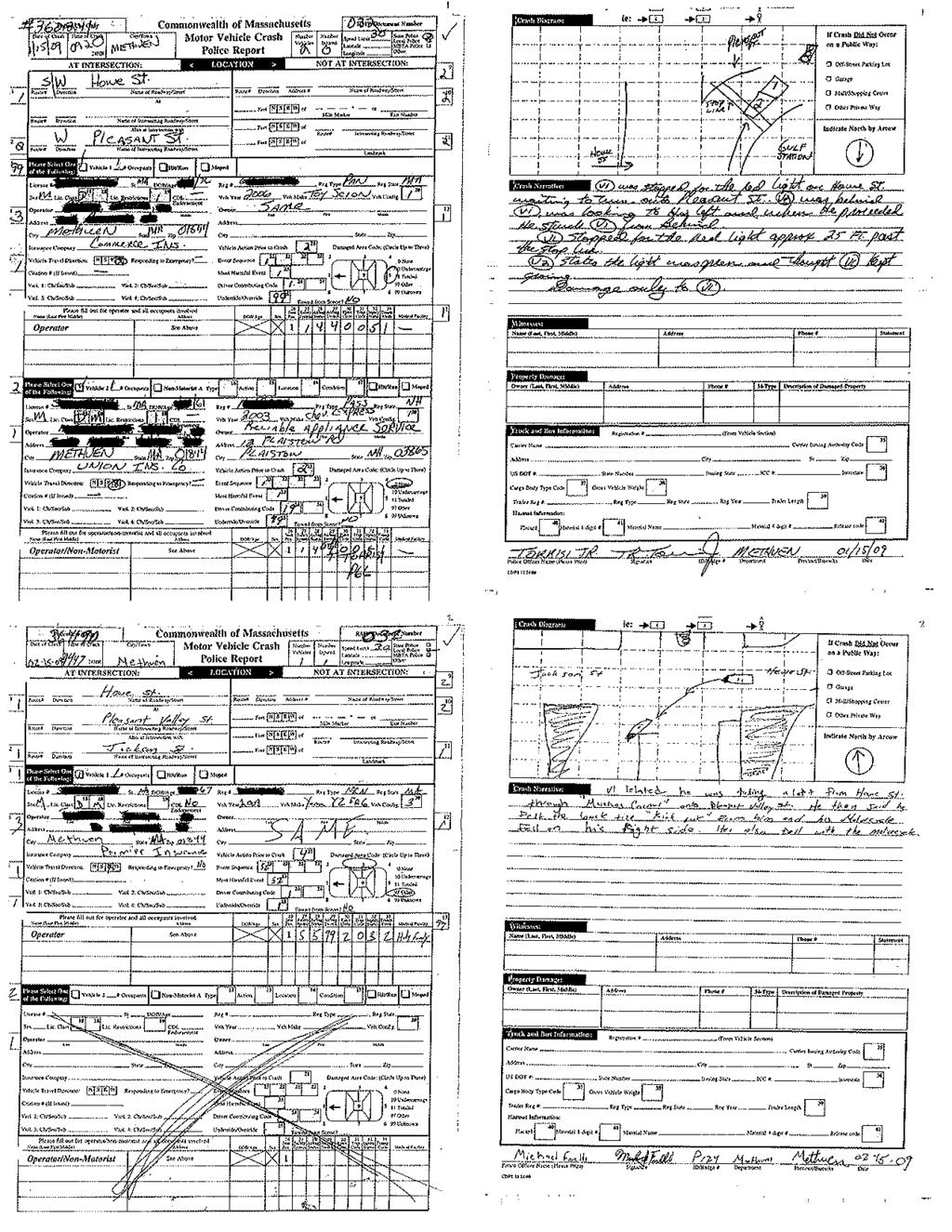
44
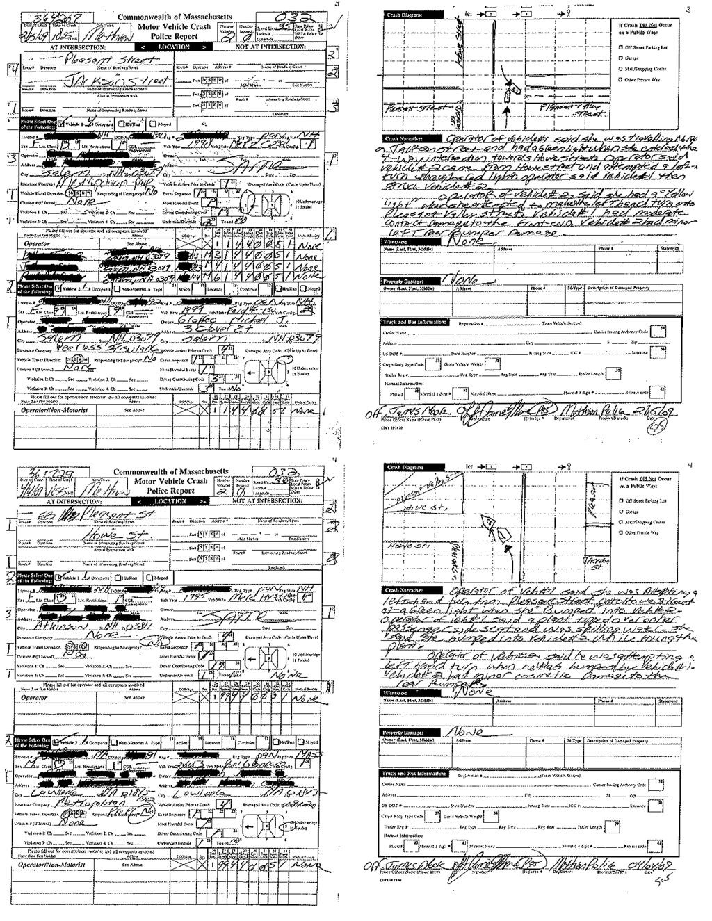
45
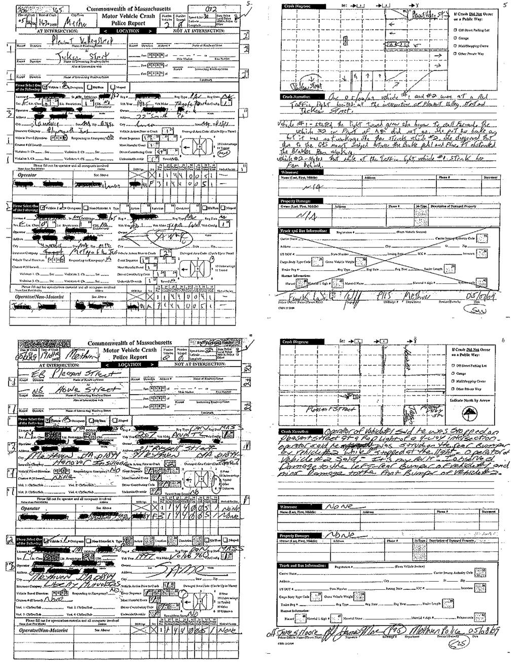
46
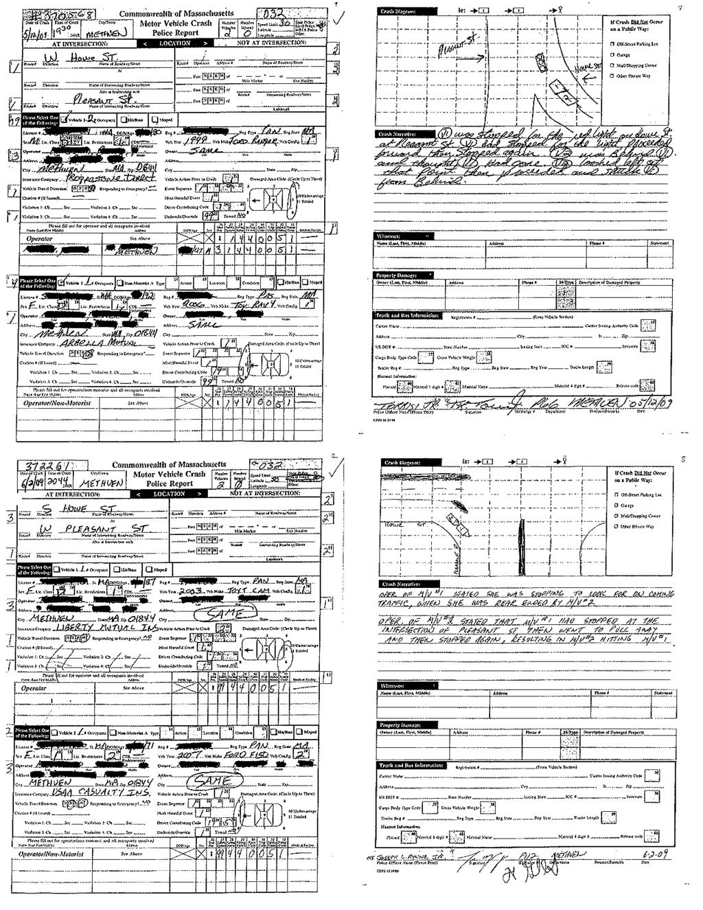
47
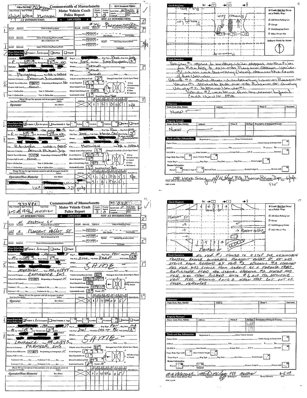
48
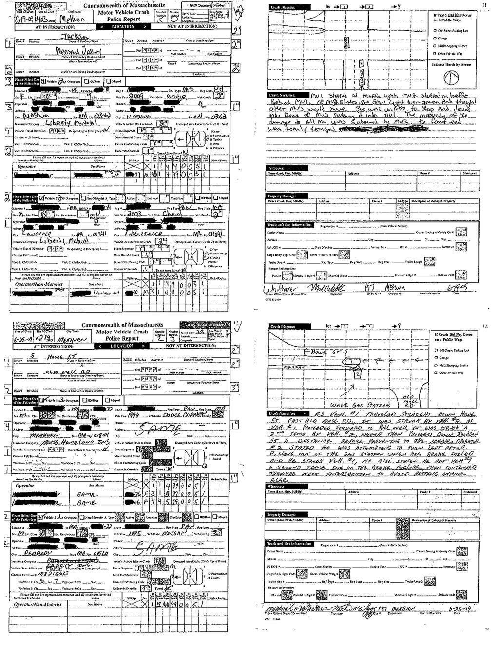
49
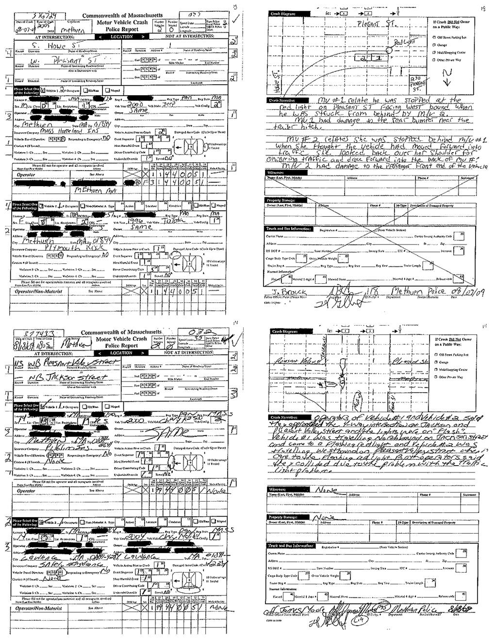
50
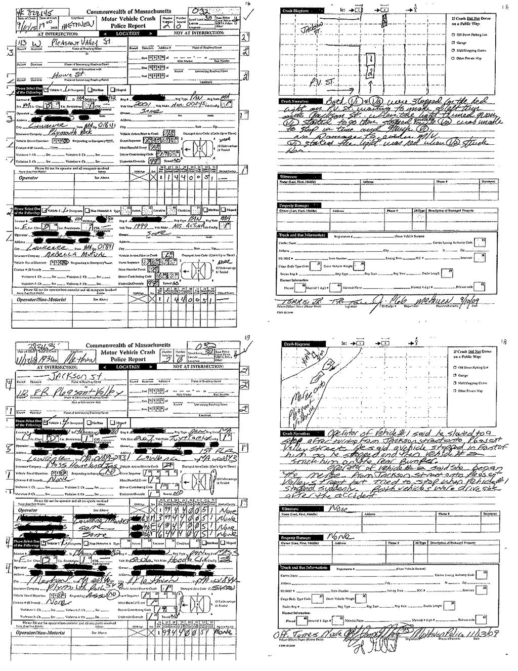
51
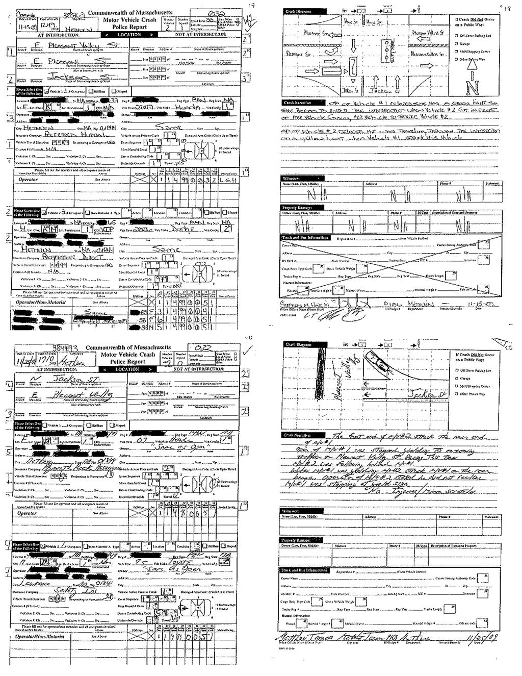
52
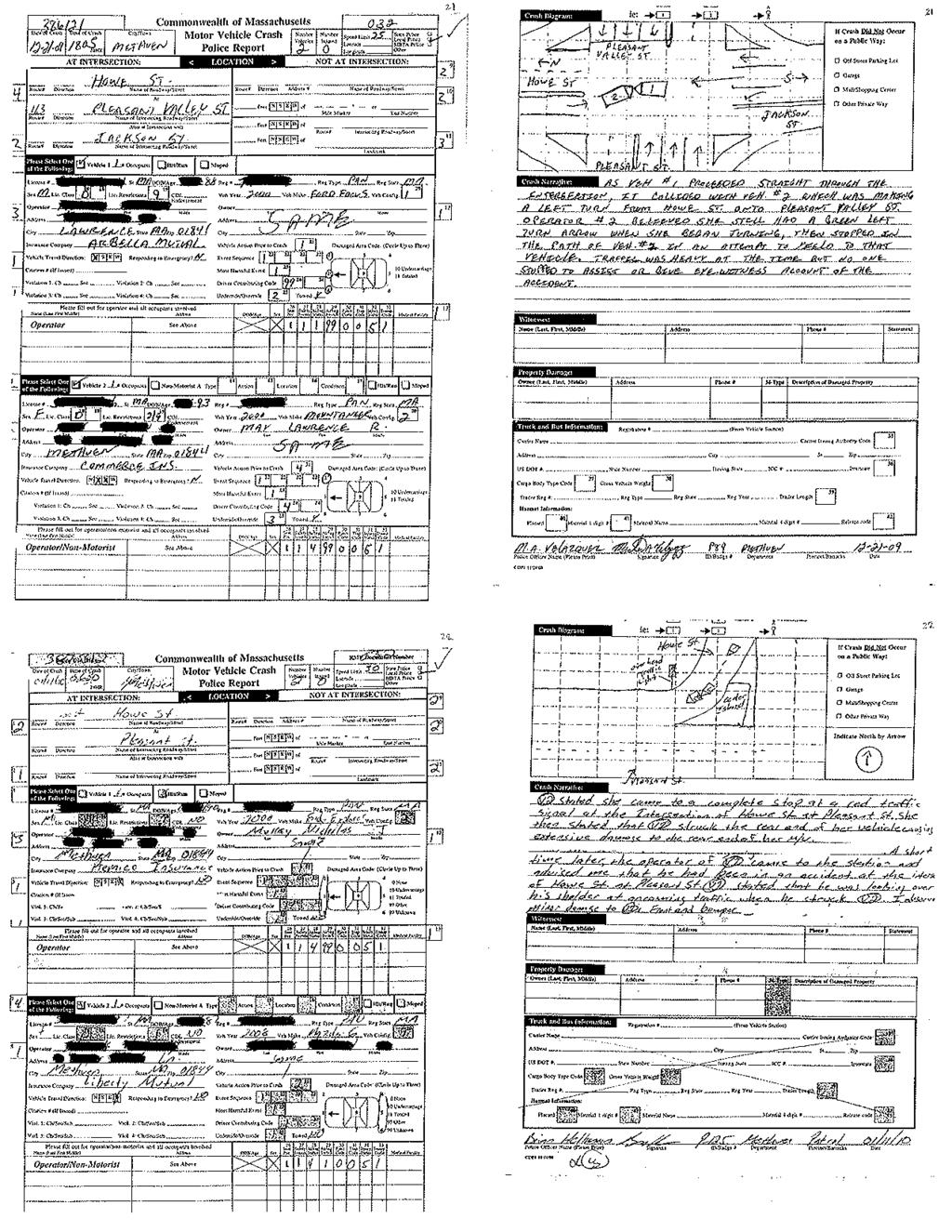
53
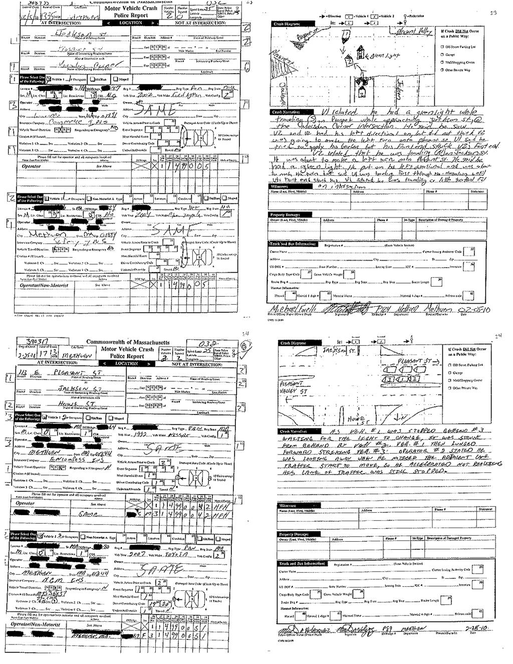
54
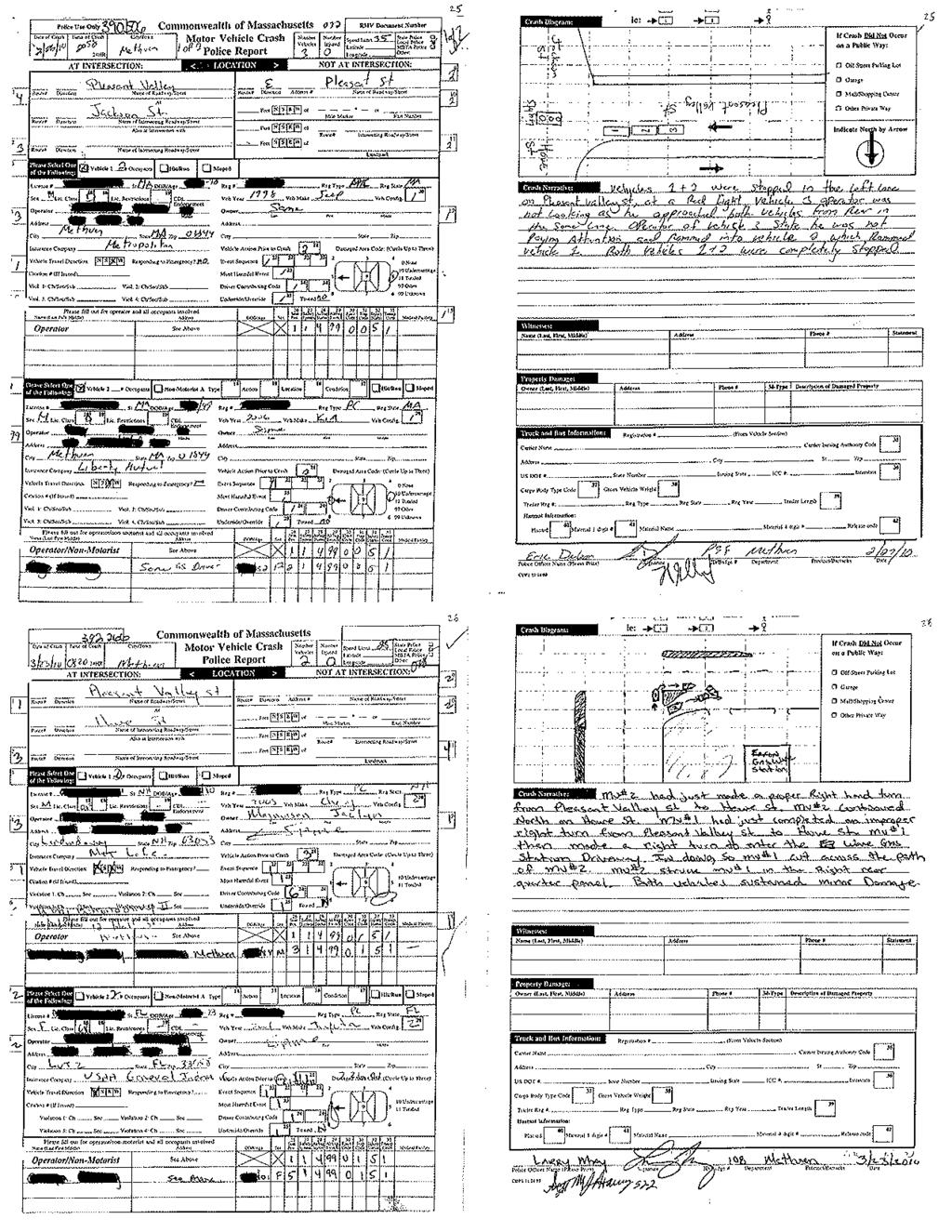
55
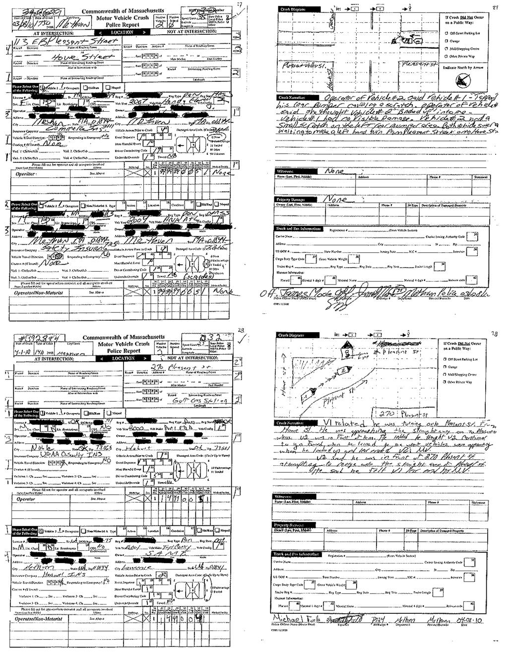
56
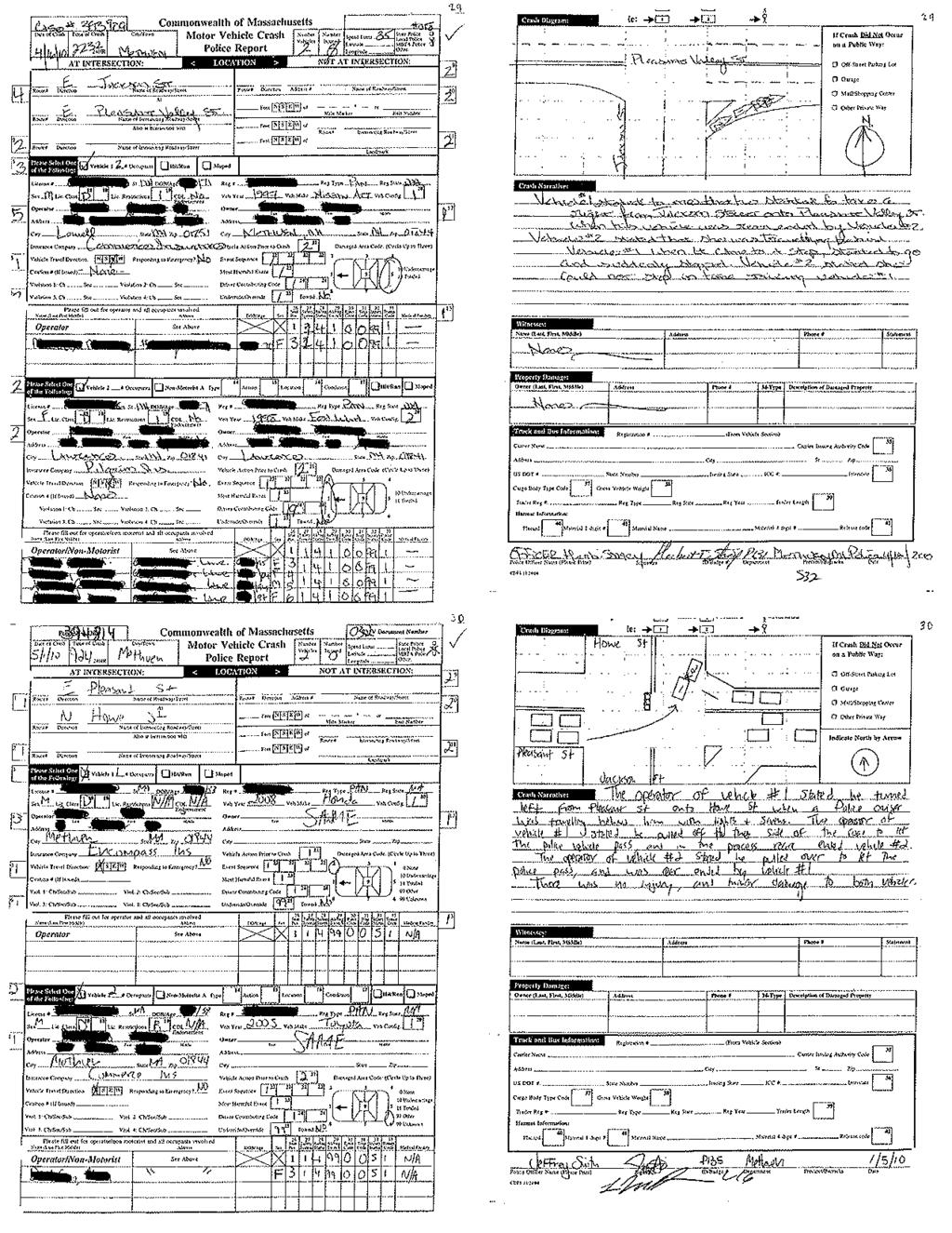
57
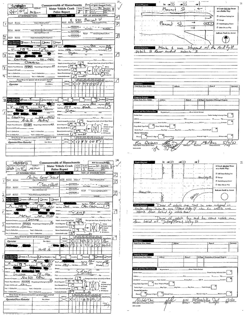
58
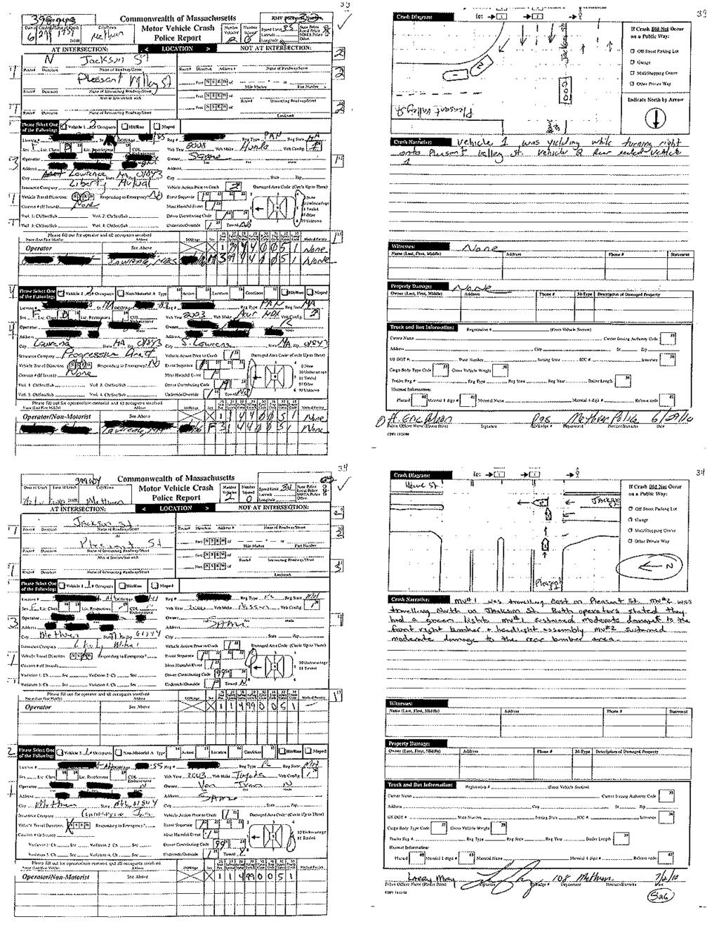
59
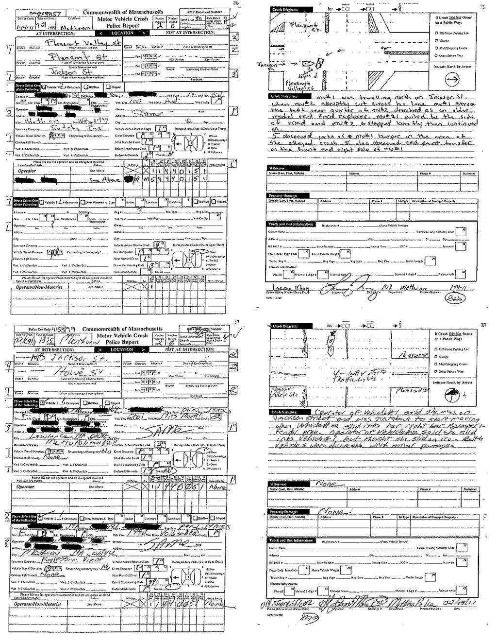
60

61
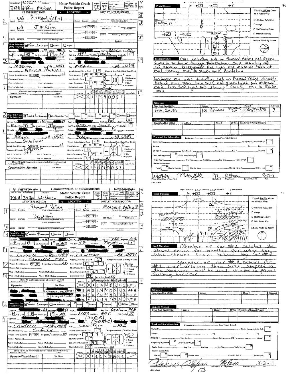
62
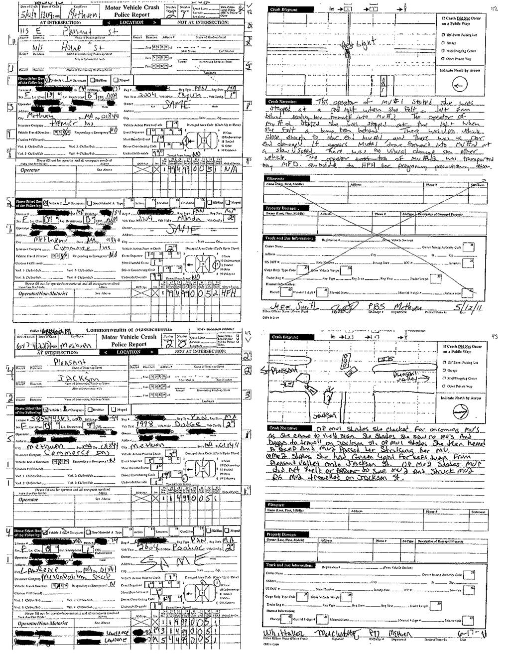
63
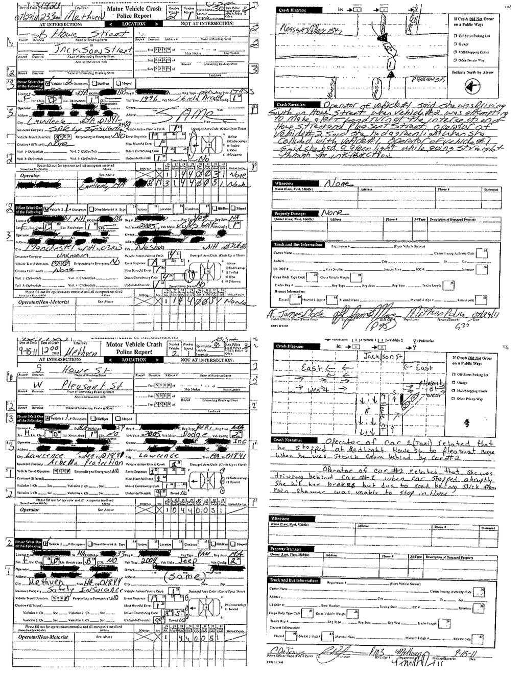
64
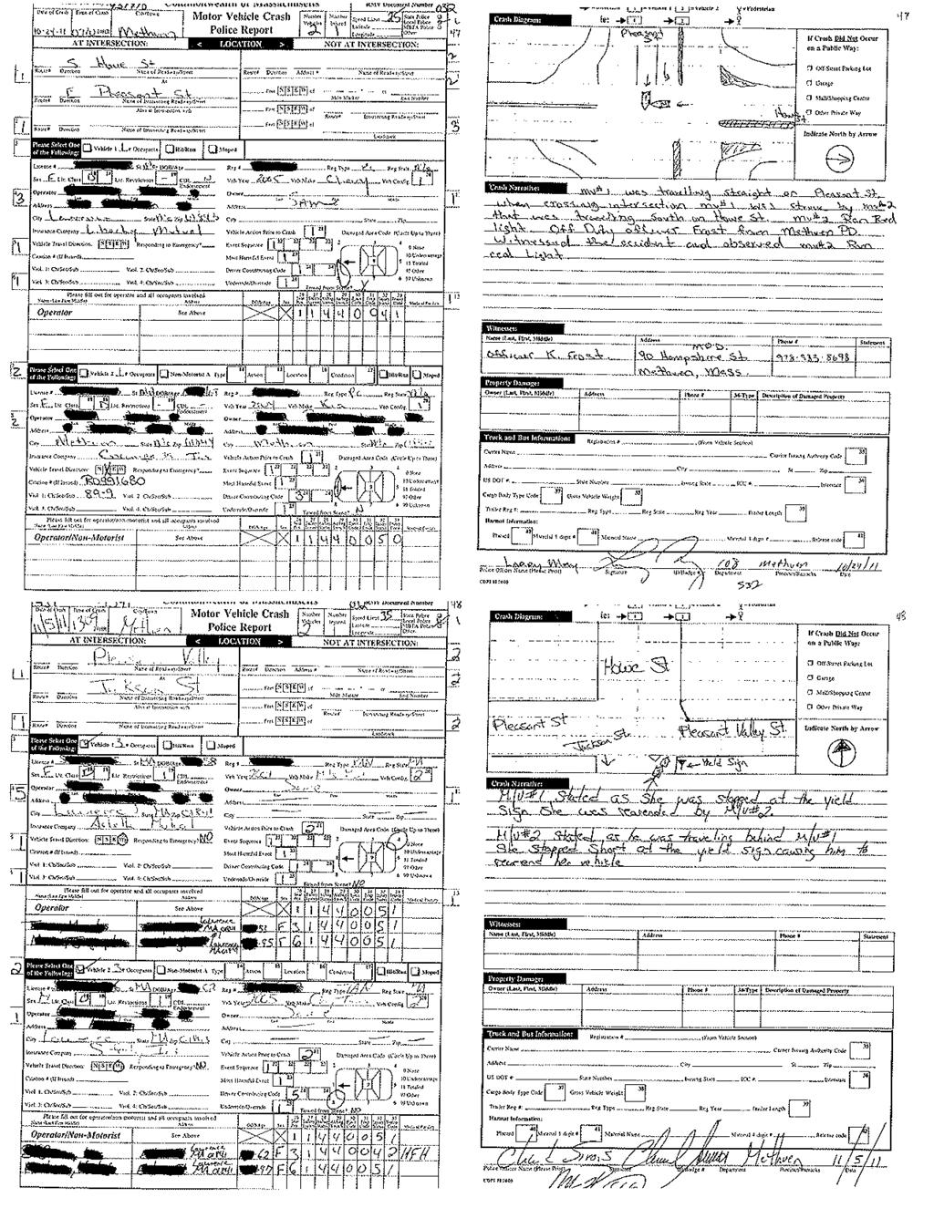
65
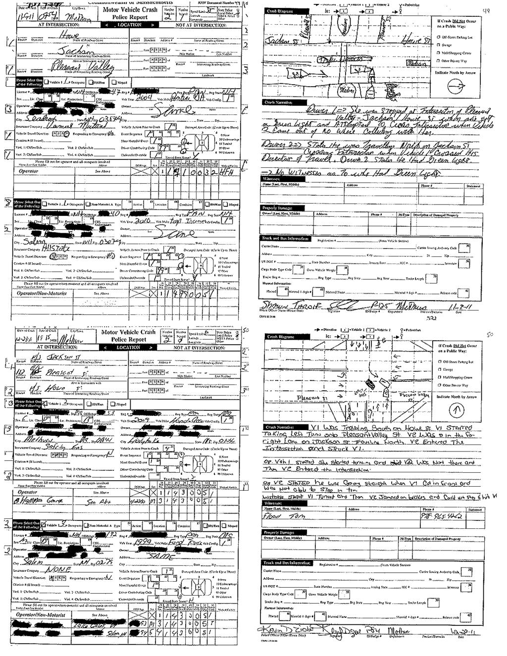
66
67 Appendix D. Roadway Speed Data
68 Appendix E. Daily and Peak Period Traffic Count Data
69
70
71
72
73
74
75
76
77 Appendix F. Crash Rate Calculation
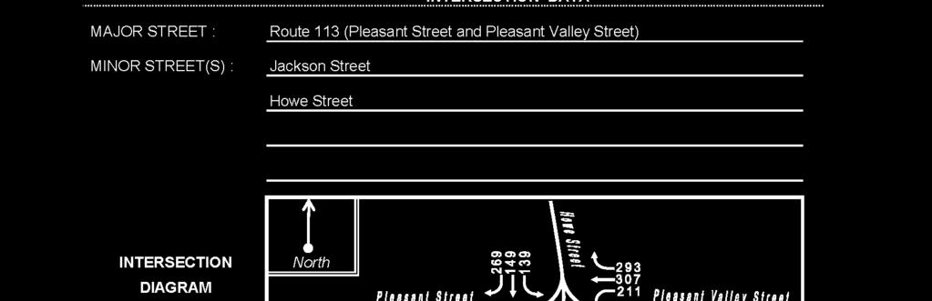
78
79 Appendix G. Intersection Operations Analysis Methodology and Results
80 OPERATIONS ANALYSIS METHODOLOGY Level of Service A primary result of capacity analyses is the assignment of level of service to traffic facilities under various traffic flow conditions. Level of service is a qualitative measure describing operational conditions within a traffic stream and the perception of these conditions by motorists and/or passengers. A level of service definition provides an index to the quality of traffic flow in terms of such factors as speed, travel time, freedom to maneuver, traffic interruptions, comfort, convenience, and safety. Six levels of service are defined for each type of facility. They are given letter designations from A to F, with level-of-service (LOS) A representing the best operating conditions and LOS F representing the worst. Since the level of service of a traffic facility is a function of the traffic flows placed upon it, such a facility may operate at a wide range of levels of service, depending on the time of day, day of week, or period of year. Signalized Intersections The six levels of service for signalized intersections may be described as follows: LOS A describes operations with very small delay; most vehicles do not stop at all. LOS B describes operations with relatively small delay; however, more vehicles stop than LOS A. LOS C describes operations with higher delays. Individual cycle failures may begin to appear in this level. The number of vehicles stopping is significant at this level, although many still pass through the intersection without stopping. LOS D describes operations with delay in the range where the influence of congestion becomes more noticeable. Many vehicles stop and individual cycle failures are noticeable. LOS E describes operations with high delay values. Individual cycle failures are frequent occurrences. LOS F describes operations with high delay values that often occur with oversaturation. Poor progression and long cycle lengths may also be major contributing causes to such delay levels.
81 Evaluation Criteria Evaluation criteria used in the capacity analyses are described below. Signalized Intersections Levels of service for signalized intersections are calculated using the operational analysis methodology of the 2010 Highway Capacity Manual. The capacity analyses for these facilities measures the average delay to drivers from signal control. This method assesses the effect of signal type, timing, phasing, progression, vehicle mix, and geometrics on delay. Level-ofservice designations are based solely on the criterion of calculated control delay, also known as signal delay. Control delay includes the initial deceleration delay, queue move-up time, stopped delay, and final acceleration delay. Delay can also be a measure of driver discomfort, frustration, fuel consumption, and increased travel time. Table A-1 summarizes the relationship between level of service and delay. The tabulated delay criterion may be applied in assigning LOS designations to individual lane groups, intersection approaches, or to entire intersections. Table A-1 LEVEL-OF-SERVICE CRITERIA FOR SIGNALIZED INTERSECTIONS a Level of Service Average Control Delay (seconds per vehicle) A <=10 B >10 and <=20 C >20 and <=35 D >35 and <=55 E >55 and <=80 F >80 a Source: Highway Capacity Manual, HCM 2010; Transportation Research Board; Washington, DC; 2010; Exhibit 18-4, page 18-6.
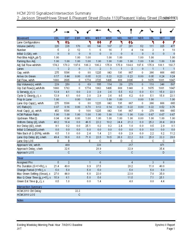
82
83
84
85
86
87
88
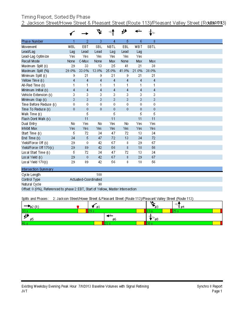
89
90
91
92
93
94
95
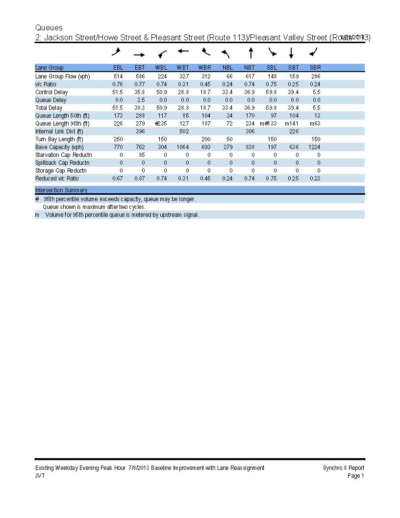
96
ROAD SAFETY AUDIT. Route 114 (Winthrop Av. And Parker St.) at Andover St. City of Lawrence. October 14, Prepared For: MassDOT
 at Andover St. City of Lawrence. October 14, Prepared For: MassDOT") ROAD SAFETY AUDIT Route 114 (Winthrop Av. And Parker St.) at Andover St. City of Lawrence October 14, 2011 Prepared For: MassDOT Prepared By: Merrimack Valley Planning Commission Road Safety Audit Route
ROAD SAFETY AUDIT Route 114 (Winthrop Av. And Parker St.) at Andover St. City of Lawrence October 14, 2011 Prepared For: MassDOT Prepared By: Merrimack Valley Planning Commission Road Safety Audit Route
Route 28 (South Orleans Road)/Route 39 (Harwich Road)/Quanset Road Intersection
/Route 39 (Harwich Road)/Quanset Road Intersection") TRAFFIC FEASIBILITY STUDY Route 28 (South Orleans Road)/Route 39 (Harwich Road)/Quanset Road Intersection Orleans, Massachusetts Prepared for: Town of Orleans Prepared by: Fay, Spofford & Thorndike, LLC
TRAFFIC FEASIBILITY STUDY Route 28 (South Orleans Road)/Route 39 (Harwich Road)/Quanset Road Intersection Orleans, Massachusetts Prepared for: Town of Orleans Prepared by: Fay, Spofford & Thorndike, LLC
MEMORANDUM. DATE March 1, 2012 TO Town of Milton Mark Abbott, Seth Asante, and Efi Pagitsas Boston Region MPO Staff
 MEMORANDUM DATE March 1, 212 TO Town of Milton FROM RE Mark Abbott, Seth Asante, and Efi Pagitsas Boston Region MPO Staff FFY 211 Safety and Operations Analyses at Selected Boston Region MPO Intersections:
Traffic Impact Analysis Walton Acres at Riverwood Athletic Club Clayton, NC
 Traffic Impact Analysis Walton Acres at Riverwood Athletic Club Clayton, NC 1. TABLE OF CONTENTS INTRODUCTION...1 1.1. Site Location and Study Area...1 1.2. Proposed Land Use and Site Access...2 1.3.
ROAD SAFETY AUDIT. Route 114 at Interstate I-495 Northbound Ramps. City of Lawrence. July 30, 2015
 ROAD SAFETY AUDIT Route 114 at Interstate I-495 Northbound Ramps City of Lawrence July 30, 2015 Prepared For: Massachusetts Department of Transportation Prepared By: Toole Design Group 33 Broad Street,
Traffic Impact Analysis Chatham County Grocery Chatham County, NC
 Chatham County Grocery Chatham County, NC TABLE OF CONTENTS 1. INTRODUCTION... 1 1.1. Location and Study Area... 1 1.2. Proposed Land Use and Access... 2 1.3. Adjacent Land Uses... 2 1.4. Existing ways...
Chapter 4 Traffic Analysis
 Chapter 4 Traffic Analysis PURPOSE The traffic analysis component of the K-68 Corridor Management Plan incorporates information on the existing transportation network, such as traffic volumes and intersection
Evaluation of M-99 (Broad Street) Road Diet and Intersection Operational Investigation
 Road Diet and Intersection Operational Investigation") Evaluation of M-99 (Broad Street) Road Diet and Intersection Operational Investigation City of Hillsdale, Hillsdale County, Michigan June 16, 2016 Final Report Prepared for City of Hillsdale 97 North Broad
Evaluation of M-99 (Broad Street) Road Diet and Intersection Operational Investigation City of Hillsdale, Hillsdale County, Michigan June 16, 2016 Final Report Prepared for City of Hillsdale 97 North Broad
ALLEY 24 TRAFFIC STUDY
 ALLEY 24 TRAFFIC STUDY in City of Frostburg, Maryland January 2013 3566 Teays Valley Road Hurricane, WV Office: (304) 397-5508 www.denniscorporation.com Alley 24 Traffic Study January 2013 Frostburg, Maryland
TRAFFIC IMPACT ANALYSIS
 TRAFFIC IMPACT ANALYSIS FOR THE CHAMPAIGN UNIT#4 SCHOOL DISTRICT PROPOSED HIGH SCHOOL (SPALDING PARK SITE) IN THE CITY OF CHAMPAIGN Final Report Champaign Urbana Urbanized Area Transportation Study 6/24/2014
Highway 49, Highway 351 and Highway 91 Improvements Feasibility Study Craighead County
 Highway 49, Highway 351 and Highway 91 Improvements Feasibility Study Craighead County Executive Summary March 2015 Highway 49, Highway 351 and Highway 91 Improvements Feasibility Study Craighead County
MEMORANDUM. Layout Of Study Intersections And Traffic Control
 BOSTON REGION METROPOLITAN PLANNING ORGANIZATION Richard A. Davey, MassDOT Secretary and CEO and MPO Chairman Karl H. Quackenbush, Executive Director, MPO Staff DATE November 15, 2012 TO FROM RE Town of
Traffic Study of Fuller Street, Cady Street, West Street and West Avenue. Final Report
 Traffic Study of Fuller Street, Cady Street, West Street and West Avenue Final Report July 2005 Prepared for: Town of Ludlow Prepared by: Pioneer Valley Planning Commission 26 Central Street West Springfield,
OFFICE/RETAIL DEVELOPMENT 1625 BANK STREET OTTAWA, ONTARIO TRANSPORTATION BRIEF. Prepared for: Canada Inc.
 OFFICE/RETAIL DEVELOPMENT 1625 BANK STREET OTTAWA, ONTARIO TRANSPORTATION BRIEF Prepared for: 9402209 Canada Inc. December 15, 2015 115-625 Report_2.doc D. J. Halpenny & Associates Ltd. Consulting Transportation
Glenn Avenue Corridor Traffic Operational Evaluation
 Glenn Avenue Corridor Traffic Operational Evaluation PREPARED FOR: THE CITY OF AUBURN PREPARED BY: DECEMBER 2007 Glenn Avenue Corridor Study--Auburn, Alabama TABLE OF CONTENTS Introduction... 1 Background
Date: April 4, Project #: Re: A Street/Binford Street Traffic/Intersection Assessment
 To: Peter Cavanaugh General Electric From: David Bohn, PE Ryan White, PE Date: April 4, 217 Project #: 13421. Re: / Traffic/Intersection Assessment Consistent with the Cooperation Agreement between the
TRAFFIC ACCIDENT ANALYSIS
 TRAFFIC ACCIDENT ANALYSIS Westheimer at Chimney Rock and Westheimer at Dunvale Prepared for Prepared by Klotz Associates, Inc. 1160 Dairy Ashford, Suite 500 Houston, Texas 77079 The preparation of this
Capital Region Council of Governments
 March 23, 2018 Capital Region Council of Governments PROJECT CONCEPT REPORT Realignment of Swamp and Northfield Road s approaches to Route 44 (Boston Turnpike) Town of Coventry SUMMARY: The Town of Coventry
MEMORANDUM. Charlotte Fleetwood, Transportation Planner
 MEMORANDUM Date: Updated August 22, 2017 To: Organization: Charlotte Fleetwood, Transportation Planner Boston Transportation Department From: Jason DeGray, P.E., PTOE, Regional Director of Engineering
Gateway Transportation Study
 Gateway Transportation Study Amherst, Massachusetts SUBMITTED TO University of Massachusetts Amherst Town of Amherst SUBMITTED BY Vanasse Hangen Brustlin, Inc. Watertown, Massachusetts March 213 Back of
ROAD SAFETY AUDIT. Northampton Road (Route 9) at University Drive and Snell Street Town of Amherst. November 15, Prepared For: MassDOT
 at University Drive and Snell Street Town of Amherst. November 15, Prepared For: MassDOT") ROAD SAFETY AUDIT Northampton Road (Route 9) at University Drive and Snell Street Town of Amherst November 15, 2016 Prepared For: MassDOT Prepared By: Greenman-Pedersen, Inc. 181 Ballardvale Street, Suite
ROAD SAFETY AUDIT Northampton Road (Route 9) at University Drive and Snell Street Town of Amherst November 15, 2016 Prepared For: MassDOT Prepared By: Greenman-Pedersen, Inc. 181 Ballardvale Street, Suite
ROAD SAFETY AUDIT. Blue Hill Avenue (Route 28) and Warren Street High Crash Locations City of Boston. November 1, 2016
 and Warren Street High Crash Locations City of Boston. November 1, 2016") ROAD SAFETY AUDIT Blue Hill Avenue (Route 28) and Warren Street High Crash Locations City of Boston November 1, 2016 Prepared For: MassDOT Highway Division Prepared By: BETA Group, Inc. Table of Contents
ROAD SAFETY AUDIT Blue Hill Avenue (Route 28) and Warren Street High Crash Locations City of Boston November 1, 2016 Prepared For: MassDOT Highway Division Prepared By: BETA Group, Inc. Table of Contents
PEDESTRIAN SAFETY STUDY
 PEDESTRIAN SAFETY STUDY SR 699 (BLIND PASS RD/GULF BLVD) FROM 93 RD AVENUE TO PINELLAS BAYWAY PINELLAS COUNTY SECTION NO.: 15100 MILEPOST: 0.111 3.569 STUDY LIMITS Prepared For: Florida Department of Transportation
TRANSPORTATION ANALYSIS REPORT US Route 6 Huron, Erie County, Ohio
 TRANSPORTATION ANALYSIS REPORT US Route 6 Huron, Erie County, Ohio December 12, 2012 Prepared for: The City of Huron 417 Main Huron, OH 44839 Providing Practical Experience Technical Excellence and Client
ROAD SAFETY AUDIT. State Road (Route 6) Corridor Town of Dartmouth. March Prepared For: MassDOT
 Corridor Town of Dartmouth. March Prepared For: MassDOT") ROAD SAFETY AUDIT State Road (Route 6) Corridor Town of Dartmouth March 2015 Prepared For: MassDOT Prepared By: McMahon Associates, Inc. 300 Myles Standish Blvd. Suite 201 Taunton, MA 02780 Table of Contents
ROAD SAFETY AUDIT State Road (Route 6) Corridor Town of Dartmouth March 2015 Prepared For: MassDOT Prepared By: McMahon Associates, Inc. 300 Myles Standish Blvd. Suite 201 Taunton, MA 02780 Table of Contents
METHODOLOGY. Signalized Intersection Average Control Delay (sec/veh)
") Chapter 5 Traffic Analysis 5.1 SUMMARY US /West 6 th Street assumes a unique role in the Lawrence Douglas County transportation system. This principal arterial street currently conveys commuter traffic
Chapter 5 Traffic Analysis 5.1 SUMMARY US /West 6 th Street assumes a unique role in the Lawrence Douglas County transportation system. This principal arterial street currently conveys commuter traffic
CITY OF WEST LAKE HILLS. Forest View Neighborhood Traffic Calming Study
 CITY OF WEST LAKE HILLS 901 South Mopac Expressway Building V, Suite 220 Austin, Texas 78746 Texas P.E. Firm Registration No. F-929 Klotz Associates Final Report Submittal: March 20, 2015 Revised Final
ROAD SAFETY AUDIT. May 18, Prepared For: MassDOT. On Behalf Of: Town of Milford
 ROAD SAFETY AUDIT East Main Street (Route 16) at Medway Road (Route 109), East Main Street (Route 16) at Quarry Square Driveways, East Main Street (Route 16) at Beaver Street/ Fortune Boulevard Town of
Meadow Woods Elementary School
 Drag and drop pic and stretch/crop to the limits of the blue rectangle (delete this text box) Meadow Woods Elementary School Drag and drop pic and stretch/crop to the limits of the blue rectangle (delete
Truck Climbing Lane Traffic Justification Report
 ROUTE 7 (HARRY BYRD HIGHWAY) WESTBOUND FROM WEST MARKET STREET TO ROUTE 9 (CHARLES TOWN PIKE) Truck Climbing Lane Traffic Justification Report Project No. 6007-053-133, P 101 Ι UPC No. 58599 Prepared by:
Donahue Drive Corridor Traffic Operational Evaluation
 Donahue Drive Corridor Traffic Operational Evaluation PREPARED FOR: THE CITY OF AUBURN PREPARED BY: JANUARY 2007 Donahue Drive Corridor Study--Auburn, Alabama TABLE OF CONTENTS Introduction... 1 Background
INDUSTRIAL BUILDING 1660 COMSTOCK ROAD CITY OF OTTAWA TRANSPORTATION OVERVIEW. Prepared for:
 INDUSTRIAL BUILDING 1660 COMSTOCK ROAD CITY OF OTTAWA TRANSPORTATION OVERVIEW Prepared for: Simluc Contractors Limited 2550 Blackwell Street, Ottawa K1B 5R1 October 18, 2013 113-584 Overview_1.doc D. J.
HILTON GARDEN INN HOTEL HOTEL EXPANSION 2400 ALERT ROAD, OTTAWA TRANSPORTATION BRIEF. Prepared for:
 HILTON GARDEN INN HOTEL HOTEL EXPANSION 2400 ALERT ROAD, OTTAWA TRANSPORTATION BRIEF Prepared for: Bona Building & Management Co. Ltd. Place Vanier, 333 North River Road Vanier, Ontario K1L 8B9 October
INDUSTRIAL BUILDING 3009 HAWTHORNE ROAD CITY OF OTTAWA TRANSPORTATION OVERVIEW REVISED. Prepared for: Canada Inc.
 INDUSTRIAL BUILDING 3009 HAWTHORNE ROAD CITY OF OTTAWA TRANSPORTATION OVERVIEW REVISED Prepared for: 7849648 Canada Inc. Octiober 1, 2015 114-598 Overview_2.doc D. J. Halpenny & Associates Ltd. Consulting
MEMORANDUM. Nantasket Road at Kingsley Road Kingsley Road at Sumner Street Kingsley Road at Revere Street Kingsley Road at Kenberma Street
 MEMORANDUM Date: June 28, 2012 To: From: Subject: Mr. Joseph Stigliani, Director of Public Works Kenneth J. Petraglia, P.E., PTOE Greg E. Lucas, P.E., PTOE Kingsley Road Stop Sign Warrant Analysis BETA
CAPE COD COMMISSION 3225 MAIN STREET P.O. BOX 226 BARNSTABLE, MA (508) Fax (508) Transportation Safety Report
 Fax (508) Transportation Safety Report") CAPE COD COMMISSION 3225 MAIN STREET P.O. BOX 226 BARNSTABLE, MA 02630 (508) 362-3828 Fax (508) 362-3136 2006 Transportation Safety Report Bourne: Otis Rotary Harwich: Route 137/Route 39 Orleans: Route
CAPE COD COMMISSION 3225 MAIN STREET P.O. BOX 226 BARNSTABLE, MA 02630 (508) 362-3828 Fax (508) 362-3136 2006 Transportation Safety Report Bourne: Otis Rotary Harwich: Route 137/Route 39 Orleans: Route
MEETING FACILITY 2901 GIBFORD DRIVE CITY OF OTTAWA TRANSPORTATION BRIEF. Prepared for: Holiday Inn Express 2881 Gibford Drive Ottawa, ON K1V 2L9
 MEETING FACILITY 2901 GIBFORD DRIVE CITY OF OTTAWA TRANSPORTATION BRIEF Prepared for: Holiday Inn Express 2881 Gibford Drive Ottawa, ON K1V 2L9 December 18, 2012 112-566 Brief_1.doc D. J. Halpenny & Associates
QUICKIE C STORE AND GAS BAR 1780 HERON ROAD OTTAWA, ONTARIO TRANSPORTATION BRIEF. Prepared for:
 QUICKIE C STORE AND GAS BAR 1780 HERON ROAD OTTAWA, ONTARIO TRANSPORTATION BRIEF Prepared for: Quickie Convenience Stores Larny Holdings Ltd. c/o PBC Group April 15, 2015 115-615 Report_1.doc D. J. Halpenny
Dell Range Boulevard Corridor Study Powderhouse Road to College Drive. Prepared for: Cheyenne Metropolitan Planning Organization
 Dell Range Boulevard Corridor Study Powderhouse Road to College Drive Prepared for: Cheyenne Metropolitan Planning Organization Draft August 2014 Dell Range Boulevard Corridor Study (Powderhouse Road to
Figure 1: Vicinity Map of the Study Area
 ARIZONA TEXAS NEW MEXICO OKLAHOMA May 5, 2016 Mr. Anthony Beach, P.E. BSP Engineers 4800 Lakewood Drive, Suite 4 Waco, Texas 76710 Re: Intersection and Access Analysis along Business 190 in Copperas Cove
Lake Whitney Elementary School
 Lake Whitney Elementary School SCHOOL ROUTE PLAN For LAKE WHITNEY ELEMENTARY SCHOOL LOCATION 18 ORANGE COUNTY Prepared for: ORANGE COUNTY SCHOOL ASSESSMENT PROGRAM ORANGE COUNTY PUBLIC WORKS Traffic Engineering
Drag and drop pic and stretch/crop to the limits of the blue rectangle (delete this text box) Maxey Elementary School
 Maxey Elementary School") Drag and drop pic and stretch/crop to the limits of the blue rectangle (delete this text box) Maxey Elementary School SCHOOL ROUTE PLAN For MAXEY ELEMENTARY SCHOOL LOCATION 33 ORANGE COUNTY Prepared for:
Drag and drop pic and stretch/crop to the limits of the blue rectangle (delete this text box) Maxey Elementary School SCHOOL ROUTE PLAN For MAXEY ELEMENTARY SCHOOL LOCATION 33 ORANGE COUNTY Prepared for:
TRAFFIC IMPACT STUDY
 TRAFFIC IMPACT STUDY for the GLEN ELLEN COUNTRY CLUB SENIOR RESIDENTIAL REDEVELOPMENT 84 Millis, Massachusetts Prepared by: McMahon Associates, Inc. Prepared for: Toll Brothers, Inc. August 216 DRAFT
ROAD SAFETY AUDIT. Russell Street (Route 9) at North and South Maple Streets Town of Hadley. March 2014
 at North and South Maple Streets Town of Hadley. March 2014") ROAD SAFETY AUDIT Russell Street (Route 9) at North and South Maple Streets Town of Hadley March 2014 Prepared for: Massachusetts Department of Transportation Prepared by: Howard/Stein-Hudson Associates
ROAD SAFETY AUDIT Russell Street (Route 9) at North and South Maple Streets Town of Hadley March 2014 Prepared for: Massachusetts Department of Transportation Prepared by: Howard/Stein-Hudson Associates
Deer Street Parking Garage & Deer Street Associates Development
 Traffic Impact and Access Study Deer Street Parking Garage & Deer Street Associates Development Portsmouth, New Hampshire Submitted to: City of Portsmouth, New Hampshire 1 Junkins Avenue Portsmouth, New
March 11, Lynnfield Board of Selectmen Town of Lynnfield 55 Summer Street Lynnfield, MA Walnut Street Traffic Assessment
 March 11, 2015 Lynnfield Board of Selectmen Town of Lynnfield 55 Summer Street Lynnfield, MA 01940 Re: Walnut Street Traffic Assessment Dear Board of Selectmen Members: As requested, BETA Group, Inc. (BETA)
FLORIDA DEPARTMENT OF TRANSPORTATION DISTRICT 7 DISTRICT WIDE BICYCLE/PEDESTRIAN ACCESS TO TRANSIT SAFETY ASSESSMENT AND IMPROVEMENT PLAN
 FLORIDA DEPARTMENT OF TRANSPORTATION DISTRICT 7 DISTRICT WIDE BICYCLE/PEDESTRIAN ACCESS TO TRANSIT SAFETY ASSESSMENT AND IMPROVEMENT PLAN TRANSIT SAFETY ASSESSMENT SR 55/US 19 AT 80 TH AVE N DRAFT JUNE
NEW YORK CENTRAL PARK SUBDIVISION BLAIS STREET/ST-PIERRE STREET EMBRUN, ONTARIO TRAFFIC IMPACT STUDY. Prepared for:
 NEW YORK CENTRAL PARK SUBDIVISION BLAIS STREET/ST-PIERRE STREET EMBRUN, ONTARIO TRAFFIC IMPACT STUDY Prepared for: Solidex Holdings Limited & Investissement Maurice Lemieux Investments Attn: Mr. Anthony
URBAN QUARRY HEADQUARTERS 2717 STEVENAGE DRIVE CITY OF OTTAWA TRANSPORTATION OVERVIEW. Prepared for: Urban Quarry 4123 Belgreen Drive, Ottawa K1G 3N2
 URBAN QUARRY HEADQUARTERS 2717 STEVENAGE DRIVE CITY OF OTTAWA TRANSPORTATION OVERVIEW Prepared for: Urban Quarry 4123 Belgreen Drive, Ottawa K1G 3N2 February 27, 2014 113-584 Overview_1.doc D. J. Halpenny
Traffic Impact Study WestBranch Residential Development Davidson, NC March 2016
 Traffic Impact Study WestBranch Residential Development Davidson, NC March 216 TRAFFIC IMPACT STUDY FOR THE WestBranch Residential Development LOCATED IN DAVIDSON, NC Prepared For: Lennar Carolinas, LLC
ROAD SAFETY AUDIT. Route 38 from Route 62 to Woburn Town Line. Town of Wilmington. April 10, Prepared For: MassDOT
 ROAD SAFETY AUDIT Route 38 from Route 62 to Woburn Town Line Town of Wilmington April 10, 2017 Prepared For: MassDOT Prepared By: Green International Affiliates, Inc. 239 Littleton Road, Suite 3, Westford,
Truck Turning Study for Main Street Intersection, Orange
 Truck Turning Study for Main Street Intersection, Orange Franklin Regional Council of Governments September 2015 0 Truck Turning Study for Main Street Intersection, Orange September 2015 Prepared by: Franklin
I-95 Northbound at US 1 (Exit 126) Design and Study Final Report
 Design and Study Final Report") I-95 Northbound at US 1 (Exit 126) Design and Study Final Report July 2018 Prepared by: Prepared for: TABLE OF CONTENTS 1 Introduction... 1 Study Area Limits... 1 Purpose and Need of the Study... 1 Safety
I-95 Northbound at US 1 (Exit 126) Design and Study Final Report July 2018 Prepared by: Prepared for: TABLE OF CONTENTS 1 Introduction... 1 Study Area Limits... 1 Purpose and Need of the Study... 1 Safety
3 ROADWAYS 3.1 CMS ROADWAY NETWORK 3.2 TRAVEL-TIME-BASED PERFORMANCE MEASURES Roadway Travel Time Measures
 ROADWAYS Approximately 6 million trips are made in the Boston metropolitan region every day. The vast majority of these trips (80 to percent, depending on trip type) involve the use of the roadway network
CITY OF OAKLAND. 27th Street Bikeway Feasibility and Design. Final Report (v3) March 23, Kimley-Horn and Associates, Inc.
 March 23, Kimley-Horn and Associates, Inc.") CITY OF OAKLAND 27th Street Bikeway Feasibility and Design Final Report (v3) March 23, 2007 PREPARED BY: Kimley-Horn and Associates, Inc. Table of Contents 1. Introduction 3 2. 27 th Street/Bay Place Corridor
CITY OF OAKLAND 27th Street Bikeway Feasibility and Design Final Report (v3) March 23, 2007 PREPARED BY: Kimley-Horn and Associates, Inc. Table of Contents 1. Introduction 3 2. 27 th Street/Bay Place Corridor
Existing Conditions. Date: April 16 th, Dan Holderness; Coralville City Engineer Scott Larson; Coralville Assistant City Engineer
 Date: April 16 th, 2015 To: From: Re: Dan Holderness; Coralville City Engineer Scott Larson; Coralville Assistant City Engineer Darian Nagle-Gamm, Traffic Engineering Planner Highway 6 (2 nd Street) /
STILLWATER AVENUE CORRIDOR STUDY Old Town, Maine
 Draft Study STILLWATER AVENUE CORRIDOR STUDY Old Town, Maine SUBMITTED TO: BANGOR AREA COMPREHENSIVE TRANSPORTATION SYSTEM SUBMITTED BY: I MAY 23, 2017 DRAFT STILLWATER AVENUE STUDY FINAL REPORT Table
Walmart (Store # ) 60 th Street North and Marion Road Sioux Falls, South Dakota
 60 th Street North and Marion Road Sioux Falls, South Dakota") Walmart (Store #4865-00) 60 th Street North and Marion Road Sioux Falls, South Dakota Prepared for: Wal-Mart Stores, Inc. Bentonville, Arkansas Prepared by: Kimley-Horn and Associates, Inc. ã2013 Kimley-Horn
Walmart (Store #4865-00) 60 th Street North and Marion Road Sioux Falls, South Dakota Prepared for: Wal-Mart Stores, Inc. Bentonville, Arkansas Prepared by: Kimley-Horn and Associates, Inc. ã2013 Kimley-Horn
Draft North Industrial Area-Wide Traffic Plan
 Summary of North Industrial and Hudson Bay Industrial Recommended Improvements Table 1. Summary of s Item Location 1 2 3 4 5 6 7 8 9 10 11 12 Millar Ave north of 51st St Super 8 Motel back lane 400 Block
Traffic Impact and Access Study PROPOSED DURKEE FARM ESTATES. Foster Street Littleton, Massachusetts. Prepared for: Grimes Road, LLC.
 Traffic Impact and Access Study PROPOSED DURKEE FARM ESTATES Foster Street Littleton, Massachusetts Prepared for: Grimes Road, LLC. Westford, MA Prepared by: MDM Transportation Consultants, Inc. 28 Lord
Traffic Signal Redesign 50% Design Report
 Traffic Signal Redesign 50% Design Report Joseph Davis, Jace Elkins, Jordan Weyrauch and Zach Crimmins CENE 486 Capstone J3Z Engineering March 10 th, 2016 Table of Contents 1.0 Project Description...1
FAIRFIELD INN & SUITES HOTEL 135 THAD JOHNSON PRIVATE OTTAWA TRANSPORTATION BRIEF. Prepared for:
 FAIRFIELD INN & SUITES HOTEL 135 THAD JOHNSON PRIVATE OTTAWA TRANSPORTATION BRIEF Prepared for: Bona Building & Management Co. Ltd. Place Vanier, 333 North River Road Vanier, Ontario K1L 8B9 August 12,
Cheyenne Metropolitan Planning Organization
 Dell Range Boulevard Corridor Study PHASE II SECTION 20 DRAFT Prepared for: Cheyenne Metropolitan Planning Organization November 20, 2015 (Section 20 is bordered by Powderhouse Road on the west, Storey
ROAD SAFETY AUDIT. Route 135 at Route 30 Town of Westborough. January Prepared For: MassDOT
 ROAD SAFETY AUDIT Route 135 at Route 30 January 2016 Prepared For: MassDOT Prepared By: McMahon Associates, Inc. 300 Myles Standish Blvd. Suite 201 Taunton, MA 02780 Road Safety Audit Route 135 at Route
BELCHERTOWN. Intersection of Federal Steet (Route 9) and Bay Road MAY 2012
 and Bay Road MAY 2012") BELCHERTOWN Intersection of Federal Steet (Route 9) and Bay Road MAY 2012 Prepared Under the Direction of Pioneer Valley MPO By: Pioneer Valley Planning Commission 60 Congress Street Springfield 01104-3419
BELCHERTOWN Intersection of Federal Steet (Route 9) and Bay Road MAY 2012 Prepared Under the Direction of Pioneer Valley MPO By: Pioneer Valley Planning Commission 60 Congress Street Springfield 01104-3419
ROAD SAFETY AUDIT. Providence Street (Route 122A) at McKeon Road/Millbury Street. City of Worcester. July 14, Prepared For: MassDOT
 at McKeon Road/Millbury Street. City of Worcester. July 14, Prepared For: MassDOT") ROAD SAFETY AUDIT Providence Street (Route 122A) at McKeon Road/Millbury Street City of Worcester July 14, 2016 Prepared For: MassDOT Prepared By: Stantec Consulting Services, Inc. Burlington, Massachusetts
ROAD SAFETY AUDIT Providence Street (Route 122A) at McKeon Road/Millbury Street City of Worcester July 14, 2016 Prepared For: MassDOT Prepared By: Stantec Consulting Services, Inc. Burlington, Massachusetts
HOLIDAY INN HOTEL 235 KING EDWARD AVENUE CITY OF OTTAWA TRANSPORTATION BRIEF. Prepared for:
 HOLIDAY INN HOTEL 235 KING EDWARD AVENUE CITY OF OTTAWA TRANSPORTATION BRIEF Prepared for: Momentum Planning & Communications 1165 Greenlawn Crescent Ottawa, ON K1L 6C2 June 29, 2015 115-618 Brief_1.doc
ROAD SAFETY AUDIT. Granite Avenue at Interstate 93 Ramps. Town of Milton. May 22, Prepared for: MassDOT
 ROAD SAFETY AUDIT Granite Avenue at Interstate 93 Ramps Town of Milton May 22, 2017 Prepared for: MassDOT Prepared by: Toole Design Group 2 Oliver Street, Suite 305 Boston, MA 02109 Table of Contents Background...
JONESBORO HIGHWAY 63 HIGHWAY 18 CONNECTOR STUDY
 JONESBORO HIGHWAY 63 HIGHWAY 18 CONNECTOR STUDY Craighead County May 2007 JONESBORO HIGHWAY 63 HIGHWAY 18 CONNECTOR STUDY Craighead County May 2007 Prepared by Planning and Research Division Arkansas State
CENTRAL TRANSPORTATION PLANNING STAFF MEMORANDUM
 CTPS CENTRAL TRANSPORTATION PLANNING STAFF Staff to the Boston Region Metropolitan Planning Organization MEMORANDUM To: Thomas Cummings February 17, 2011 Holbrook Public Works Superintendent From: Re:
ROAD SAFETY AUDIT. Centre Street (Route 123) at Plymouth Street. Municipality of Brockton. November, Prepared For: MassDOT
 at Plymouth Street. Municipality of Brockton. November, Prepared For: MassDOT") ROAD SAFETY AUDIT Centre Street (Route 123) at Plymouth Street Municipality of Brockton November, 2017 Prepared For: MassDOT On Behalf Of: City of Brockton Prepared By: Old Colony Planning Council 70 School
ROAD SAFETY AUDIT Centre Street (Route 123) at Plymouth Street Municipality of Brockton November, 2017 Prepared For: MassDOT On Behalf Of: City of Brockton Prepared By: Old Colony Planning Council 70 School
ROAD SAFETY AUDIT. Rourke Bridge at Pawtucket Boulevard (Route 113) City of Lowell. October 5, Prepared For: MassDOT.
 City of Lowell. October 5, Prepared For: MassDOT.") ROAD SAFETY AUDIT Rourke Bridge at Pawtucket Boulevard (Route 113) City of Lowell October, 2017 Prepared For: MassDOT Prepared By: Vanasse Hangen Brustlin, Inc 101 Walnut Street Watertown, MA 02472 Road
ROAD SAFETY AUDIT Rourke Bridge at Pawtucket Boulevard (Route 113) City of Lowell October, 2017 Prepared For: MassDOT Prepared By: Vanasse Hangen Brustlin, Inc 101 Walnut Street Watertown, MA 02472 Road
Draft Report. Traffic Impact Study. Superstore, Wal-Mart, and Kent Development. Yarmouth, Nova Scotia. Prepared for
 oad & Traffic Management Road & Traffic Management R Atlantic Traffic Engineering Specialists Draft Report Traffic Impact Study Superstore, Wal-Mart, and Kent Development Yarmouth, Nova Scotia Prepared
Traffic Circulation Study for Neighborhood Southwest of Mockingbird Lane and Airline Road, Highland Park, Texas
 ARIZONA TEXAS NEW MEXICO OKLAHOMA February 13, 2015 Mr. Meran Dadgostar P.E., R.S. Town of Highland Park 4700 Drexel Dr. Highland Park, Texas 75205 Re: Traffic Circulation Study for Neighborhood Southwest
EXISTING (2006) CONDITIONS
 CONDITIONS") Section 2 EXISTING (2006) CONDITIONS This section provides a description of the existing transportation system in the study area and a comprehensive analysis of existing traffic operations and crash history.
Section 2 EXISTING (2006) CONDITIONS This section provides a description of the existing transportation system in the study area and a comprehensive analysis of existing traffic operations and crash history.
TECH MEMOS #3 & #4 EXISTING AND FUTURE TRAFFIC CONDITIONS TRAVEL FORECASTING APPROACH CITY OF NOVI THOROUGHFARE MASTER PLAN
 TECH MEMOS #3 & #4 EXISTING AND FUTURE TRAFFIC CONDITIONS TRAVEL FORECASTING APPROACH CITY OF NOVI THOROUGHFARE MASTER PLAN January, 2016 1. Introduction This report is prepared as part of the 2016 Novi
THIS PAGE LEFT BLANK INTENTIONALLY
 GA SR 25 Spur at Canal Road Transportation Impact Analysis PREPARED FOR GLYNN COUNTY, GEORGIA 1725 Reynolds Street, Suite 300 Brunswick, Georgia 31520 PREPARED BY 217 Arrowhead Boulevard Suite 26 Jonesboro,
AGENDA ITEM 6 D THOMASVILLE ROAD (HERMITAGE BOULEVARD TO LIVE OAK PLANTATION ROAD) ROADWAY SAFETY AUDIT
 ROADWAY SAFETY AUDIT") May 15, 2018 AGENDA ITEM 6 D THOMASVILLE ROAD (HERMITAGE BOULEVARD TO LIVE OAK PLANTATION ROAD) ROADWAY SAFETY AUDIT TYPE OF ITEM: Discussion STATEMENT OF ISSUE The Florida Department of Transportation
May 15, 2018 AGENDA ITEM 6 D THOMASVILLE ROAD (HERMITAGE BOULEVARD TO LIVE OAK PLANTATION ROAD) ROADWAY SAFETY AUDIT TYPE OF ITEM: Discussion STATEMENT OF ISSUE The Florida Department of Transportation
DEPARTMENT OF ENVIRONMENTAL SERVICES. North Harrison Street (Lee Highway to Little Falls Road) Comparative Analysis. Prepared for:
 Comparative Analysis. Prepared for:") DEPARTMENT OF ENVIRONMENTAL SERVICES North Harrison Street (Lee Highway to Little Falls Road) Comparative Analysis Prepared for: Arlington County Department of Environmental Services 2100 Clarendon Boulevard,
DEPARTMENT OF ENVIRONMENTAL SERVICES North Harrison Street (Lee Highway to Little Falls Road) Comparative Analysis Prepared for: Arlington County Department of Environmental Services 2100 Clarendon Boulevard,
A plan for improved motor vehicle access on Railroad Avenue in Provincetown
 A plan for improved motor vehicle access on Railroad Avenue in Provincetown February 2011 A plan for improved motor vehicle access on Railroad Avenue in Provincetown INTRODUCTION AND PROBLEM IDENTIFICATION
ROAD SAFETY AUDIT. County Street at Hart Street. City of Taunton. January 30, Prepared For: Massachusetts Department of Transportation
 ROAD SAFETY AUDIT County Street at Hart Street City of Taunton January 30, 2015 Prepared For: Massachusetts Department of Transportation Prepared By: Toole Design Group 33 Broad Street, 4 th Floor Boston,
TABLE OF CONTENTS 1. INTRODUCTION 2. TRAFFIC ENGINEERING FUNDAMENTALS 9. SYSTEM CONTROL 3. DATA COLLECTION 4. SIGNAL PHASING 10. SPECIAL OPERATIONS
 TABLE OF CONTENTS 1. INTRODUCTION 2. TRAFFIC ENGINEERING FUNDAMENTALS A. Volume, Demand, and Capacity 2-1 B. Performance Measures 2-7 C. Critical Lane Volume Analysis 2-9 3. DATA COLLECTION 4. SIGNAL PHASING
December 4, Merrimac Zoning Board of Appeals 2-8 School Street Merrimac, MA Attn: Kathy Marshall. Dear Board Members:
 December 4, 28 Merrimac Zoning Board of Appeals 2-8 School Street Merrimac, MA 86 Attn: Kathy Marshall RE: RAMSHEAD MERRIMAC, MA Dear Board Members: Bayside Engineering, Inc. has received the MDM Transportation
Road Safety Audit for the Intersection of VFW Highway & Bridge Street in Lowell, Massachusetts
 Road Safety Audit for the Intersection of VFW Highway & Bridge Street in Lowell, Massachusetts Prepared by University of Massachusetts Traffic Safety Research Program Prepared for Massachusetts Highway
FRONT RANGE CROSSINGS TRAFFIC IMPACT STUDY
 FRONT RANGE CROSSINGS TRAFFIC IMPACT STUDY Prepared for: City of Thornton And Colorado Department of Transportation Prepared by: 11 Blake Street, Suite 2 Denver, Colorado 822 Contact: Brian Bern, PE, PTOE
ROAD SAFETY AUDIT. Route 202 (East State Street)/School Street & Route 202 (West State Street)/Pleasant Street/Amherst Street Town of Granby
/School Street & Route 202 (West State Street)/Pleasant Street/Amherst Street Town of Granby") ROAD SAFETY AUDIT Route 202 (East State Street)/School Street & Route 202 (West State Street)/Pleasant Street/Amherst Street Town of Granby March 2013 Prepared for: Massachusetts Department of Transportation
ROAD SAFETY AUDIT Route 202 (East State Street)/School Street & Route 202 (West State Street)/Pleasant Street/Amherst Street Town of Granby March 2013 Prepared for: Massachusetts Department of Transportation
Downtown Traffic Study
 City of Lynn Massachusetts Downtown Traffic Study March 2005 315 Norwood Park South, Norwood, MA 02062 781.255.1982 email: beta@beta-inc.com LYNN DOWNTOWN TRAFFIC STUDY INTRODUCTION The City of Lynn is
Congestion Management Report
 Congestion Management Report DANIEL WEBSTER HIGHWAY, MERRIMACK Segment Length: 9.9 miles Daily Traffic Volumes: 13,000-21,000 Analysis Period: July August 2015 Number of Traffic Signals: 14 Number of travel
ROAD SAFETY AUDIT. East Main Street (Route 123) at Route I-495 Northbound & Southbound Ramps Town of Norton. May 11, Prepared For: MassDOT
 at Route I-495 Northbound & Southbound Ramps Town of Norton. May 11, Prepared For: MassDOT") ROAD SAFETY AUDIT East Main Street (Route 123) at Route I-495 Northbound & Southbound Ramps Town of Norton May 11, 2016 Prepared For: MassDOT Prepared By: 101 Walnut Street Watertown, MA Road Safety Audit
ROAD SAFETY AUDIT East Main Street (Route 123) at Route I-495 Northbound & Southbound Ramps Town of Norton May 11, 2016 Prepared For: MassDOT Prepared By: 101 Walnut Street Watertown, MA Road Safety Audit
DOWNTOWN TUPELO MAIN STREET: ROAD DIET STUDY
 DOWNTOWN TUPELO MAIN STREET: ROAD DIET STUDY Since mid-2009, RPM Transportation Consultants (RPM) has worked with the Downtown Tupelo Main Street Association to evaluate traffic conditions and potential
THE FUTURE OF THE TxDOT ROADWAY DESIGN MANUAL
 THE FUTURE OF THE TXDOT ROADWAY DESIGN MANUAL Kenneth Mora, P.E. (Design Division) 10/10/2017 Table of contents 1 2 Reduction in FHWA design controlling criteria Innovative Intersection Guidance 3-7 8-42
M-58 HIGHWAY ACCESS MANAGEMENT STUDY Mullen Road to Bel-Ray Boulevard. Prepared for CITY OF BELTON. May 2016
 M-58 HIGHWAY ACCESS MANAGEMENT STUDY Prepared for CITY OF BELTON By May 2016 Introduction Missouri State Highway 58 (M-58 Highway) is a major commercial corridor in the City of Belton. As development has
TRAFFIC CONTROL DEVICES ON EDGEWATER BOULEVARD AT PORT ROYAL AVENUE (NORTH)
") Attachment 2 DATE: August 6, 2012 TO: VIA: FROM: SUBJECT: Mayor and Members of the City Council James C. Hardy, City Manager Ramon Towne, Director of Public Works Leah Edwards, Assistant Engineer TRAFFIC
Attachment 2 DATE: August 6, 2012 TO: VIA: FROM: SUBJECT: Mayor and Members of the City Council James C. Hardy, City Manager Ramon Towne, Director of Public Works Leah Edwards, Assistant Engineer TRAFFIC
TRAFFIC ACTION PLAN. Laurie Meadows Neighborhood CITY OF SAN MATEO
 TRAFFIC ACTION PLAN Laurie Meadows Neighborhood CITY OF SAN MATEO Draft January 2017 Table of Contents Introduction... 2 The Traffic Forum Process... 5 Neighborhood Traffic Issues... 7 Neighborhood Recommendations
Traffic Impact Study Little Egypt Road Development Denver, North Carolina June 2017
 Traffic Impact Study Little Egypt Road Development Denver, North arolina June 2017 N. Little Egypt Road DQ\ QDQFLQJ VDOHV RU RWKHU SHUIRUPDQFH EDVHG FULWHULD Proposed Site Driveways Site Driveway 1 TRAFFI
Subject: Solberg Avenue / I-229 Grade Separation: Traffic Analysis
 MEMORANDUM Transportation Bill Troe, AICP Jason Carbee, AICP 12120 Shamrock Plaza Suite 300 Omaha, NE 68154 (402) 334-8181 (402) 334-1984 (Fax) To: Project File Date: Subject: Solberg Avenue / I-229 Grade
Gwinnett County Department of Transportation SR 324 / Gravel Springs Road at I-85 / SR 403 Interchange Project Number F , PI No.
 June 4, 2015 Dear Resident: Thank you for attending this public information meeting for the proposed SR 324 / Gravel Springs Road at I-85 Interchange. The purpose of this meeting is two-fold: to provide
Hidden Oaks Elementary School
 Hidden Oaks Elementary School SCHOOL ROUTE PLAN For HIDDEN OAKS ELEMENTARY SCHOOL LOCATION 13 ORANGE COUNTY Prepared for: ORANGE COUNTY SCHOOL ASSESSMENT PROGRAM ORANGE COUNTY PUBLIC WORKS Traffic Engineering
CENTRAL TRANSPORTATION PLANNING STAFF MEMORANDUM
 CTPS CENTRAL TRANSPORTATION PLANNING STAFF Staff to the Boston Region Metropolitan Planning Organization MEMORANDUM To: Martha White, Natick Town Administrator February 17, 2011 Eric Nascimento, MassDOT
HSIP Project Selection Criteria
 HSIP Project Selection Criteria The purpose of the Highway Safety Improvement Program (HSIP) is to reduce the number of fatal and injury crashes by targeting high crash locations and causes. Projects,