Meadowlake Ranch Traffic Impact Analysis (LSC #184600) August 27, 2018
|
|
|
- Alexina Gibbs
- 5 years ago
- Views:
Transcription
1 LSC TRANSPORTATION CONSULTANTS, INC. 545 East Pikes Peak Avenue, Suite 210 Colorado Springs, CO (719) FAX (719) Website: Traffic Impact Analysis (LSC #184600) August 27, 2018 Traffic Engineer s Statement This traffic report and supporting information were prepared under my responsible charge and they comport with the standard of care. So far as is consistent with the standard of care, said report was prepared in general conformance with the criteria established by the County for traffic reports. Developer s Statement I, the Developer, have read and will comply with all commitments made on my behalf within this report. Date
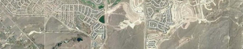
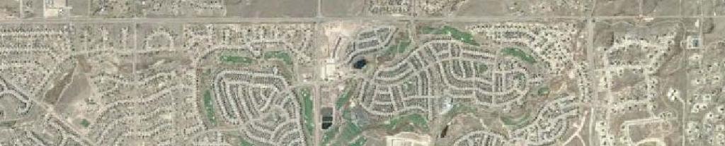
2 LSC TRANSPORTATION CONSULTANTS, INC. 545 East Pikes Peak Avenue, Suite 210 Colorado Springs, CO (719) FAX (719) Website: August 27, 2018 Mr. Dan Ferguson Judge Orr Road Peyton, CO Dear Mr. Ferguson: RE: El Paso County, Colorado Traffic Impact Analysis LSC # In response to your request, LSC Transportation Consultants, Inc. has prepared this Sketch-Planlevel traffic impact analysis for the mixed-use development in El Paso County, Colorado. As shown in Figure 1, the site is located north of Judge Orr Road between Eastonville Road and US Highway 24 in El Paso County, Colorado. REPORT CONTENTS This report is being prepared as part of a submittal to El Paso County. It identifies the traffic impacts of the mixed-use development. The report contains the following: The traffic count data and street conditions. Short-term and 2040 baseline/background traffic volume estimates. The projected average weekday and peak-hour vehicle-trips to be generated by the site. The assignment of the site s projected traffic volumes to the key area streets and intersections for the short and long term and the resulting total traffic volumes for the short and long term. The resulting traffic impacts including level of service analysis at key intersections. Findings and recommendations LAND USE AND ACCESS Figure 2 shows the proposed site plan (Sketch Plan). The acre site is planned to be developed with a mix of residential, commercial, and industrial uses. At buildout the site is assumed to include about 400 lots for single-family homes, about 660,000 square feet of floor space for industrial uses and about 173,000 square feet of floor space for commercial uses.
3 Mr. Dan Ferguson Page 2 August 27, 2018 Traffic Impact Analysis Full-movement access is proposed to Judge Orr Road about 1,355 feet west of US Highway 24 and to Eastonville Road about 1,350 feet south of Bandanero Drive. Two additional fullmovement access points are proposed to Bandanero Drive. ROADWAY AND TRAFFIC CONDITIONS Area Roadways The major roadways in the site s vicinity are shown on Figure 1 and are described below. Judge Orr Road is a two-lane roadway that extends east from Eastonville Road across most of El Paso County. It is shown on the El Paso County 2040 Major Transportation Corridors Plan (MTCP) and the Preserved Corridor Network Plan as a four-lane Minor Arterial adjacent to the site. The posted speed limit adjacent to the site is 45 miles per hour (mph). The intersection of US 24/Judge Orr is currently signalized. Due to the oblique angle of this intersection, the eastbound and westbound approaches are split phased. The US 24 Final Planning and Environmental Linkage Study (PEL) dated March 2018 shows the intersection of US 24/Judge Orr realigned to provide an intersection angle closer to 90 degrees. This is consistent with the US 24 access control plan. The PEL identifies this project as a high priority with a time line of less than five years. Eastonville Road extends northeast from Meridian Road to past Hodgen Road. It is shown as a two-lane Minor Arterial on the El Paso County Major Transportation Corridors Plan and the Preserved Corridor Network Plan. Eastonville Road has a three-lane cross-section (one through lane in each direction plus a center-two-way, left-turn lane) from Woodmen Hills Drive to Snaffle Bit Road (approximately midway between Judge Orr Road and Stapleton Road). Eastonville Road is a two-lane roadway north and south of this section. PPRTA-funded improvements are anticipated in the future at the intersection of Eastonville Road and Stapleton Drive that would likely add northbound and southbound left-turn lanes. The posted speed limit adjacent to the site is 35 mph. US Highway 24 (US 24) is generally a two-lane State Highway extending east/west across Colorado connecting the Buena Vista, Colorado Springs, and Limon areas. US 24 is planned to be widened to four lanes through the Falcon area. The US 24 PEL identifies this widening as a high priority with a time line of less than 10 years. US 24 in the vicinity is classified as an EX Expressway/Major Bypass by the Colorado Department of Transportation (CDOT). US 24 is is shown as a four-lane Principal Arterial on the MTCP and the Preserved Corridor Network Plan. The posted speed limit on US 24 transitions from 65 mph to 55 mph just north of Judge Orr Road (for westbound traffic). Stapleton Drive is shown as an Urban four-lane Principal Arterial on the El Paso County Major Transportation Corridors Plan and El Paso County Corridor Preservation Plan (CPP). Stapleton Drive extends east from Towner Drive to US Highway (US) 24. Stapleton continues southeast, then south as Curtis Road. It is planned to be ultimately extended west to connect with the Briargate Parkway extension. Stapleton Drive currently is a half-section of a four-lane
4 Mr. Dan Ferguson Page 3 August 27, 2018 Traffic Impact Analysis Principal Arterial street (one through lane in each direction) between Meridian Road and US 24. The posted speed limit between Eastonville Road and US 24 is 45 mph. Existing Traffic Volumes Figure 3 shows the existing traffic volumes at key intersections in the vicinity of the site. These volumes are based on manual intersection turning movement counts conducted by LSC in May and June 2017 and June and July The intersection counts conducted in June and July have been adjusted to school year volumes based on the May 2017 counts. The count data sheets are attached for reference. Figure 3 also shows the Colorado Department of Transportation Average Annual Daily Traffic volumes (AADT) on US 24 in the vicinity of the site and an estimate of the average weekday traffic volumes on key street segments based on the peak-hour counts. Existing Levels of Service Level of service (LOS) is a quantitative measure of the level of delay at an intersection. Level of service is indicated on a scale from A to F. LOS A represents control delay of less than 10 seconds for unsignalized and signalized intersections. LOS F represents control delay of more than 50 seconds for unsignalized intersections and more than 80 seconds for signalized intersections. Table 1 shows the level of service delay ranges. Table 1 Intersection Levels of Service Delay Ranges Signalized Intersections Unsignalized Intersections Average Control Delay Average Control Delay Level of Service (seconds per vehicle) V/C (1) (seconds per vehicle) (2) A 10.0 sec or less less than sec or less B sec sec C sec sec D sec sec E sec sec F 80.1 sec or more 1.00 and greater 50.1 sec or more (1) Source: Transportation Research Circular 212 (2) For unsignalized intersections if V/C ratio is greater than 1.0 the level of service is LOS F regardless of the projected average control delay per vehicle. Figure 3 presents the results of the existing intersection level of service analysis. The intersection of US 24/Judge Orr was analyzed using Synchro. All other intersections were analyzed based on the unsignalized method of analysis procedures from the Highway Capacity Manual, 6 th Edition by the Transportation Research Board. The level of service reports are attached.
5 Mr. Dan Ferguson Page 4 August 27, 2018 Traffic Impact Analysis All movements at the signalized intersection of Judge Orr/US 24 are currently operating at LOS D or better during the peak hours. All movements at the all-way, stop-sign-controlled intersection of Judge Orr/Meridian Ranch/ Eastonville are currently operating at LOS C or better during the peak hours. The eastbound approach at the two-way stop-sign-controlled intersection of Stapleton/ Eastonville is currently operating at LOS F during the morning peak hour. All other movements are currently operating at a LOS D or better during the peak hours. All movements at the two-way stop-sign-controlled intersections of Bandanero/Eastonville and Bandanero/Stapleton are currently operating at LOS C or better during the peak hours. SHORT-TERM (YEAR 2023) BACKGROUND TRAFFIC Background traffic is the traffic estimated to be on the adjacent roadways and at adjacent intersections without the proposed development s trip generation of site-generated traffic volumes. Background traffic includes the through traffic and the traffic generated by nearby developments but assumes zero traffic generated by the site. Figure 4 shows the projected background traffic volumes for the short term (2023). These background traffic volumes have been based on the existing traffic volumes (from Figure 3) plus increases in traffic due to regional growth including buildout of existing and currently proposed subdivisions within the Waterbury development located northeast of the intersection of Eastonville/Stapleton, Meridian Ranch Filings 1-3 and Filings 6-8, Estates Filings 2-3, Meridian Ranch Filing 11, Stonebridge Filings 1, 2, and 3, Meridian Ranch Filing 9, the Vistas at Meridian Ranch Filing 1, WindingWalk at Meridian Ranch Filing 1, The Enclave at Stonebridge at Meridian Ranch, and the Liberty Tree Academy to be located just east of the intersection of Eastonville Road and Motley Road. Figure 4 also shows the lane geometry, traffic control, and level of service at the key area intersections based on the short-term background volumes BACKGROUND TRAFFIC Figure 5 shows the projected 20-year background traffic volumes for the year The 2040 background/baseline traffic volumes are based on the Colorado Department of Transportation US 24 Planning and Environmental Linkages Study Final Corridor Conditions Report dated December 2016 and on previous work completed by LSC in the area including work done for the Meridian Ranch and Waterbury developments. The 2040 background traffic volumes do not include traffic from. Figure 5 also shows the lane geometry, traffic control, and level of service at the intersections in the vicinity of the site based on the 2040 background volumes.
6 Mr. Dan Ferguson Page 5 August 27, 2018 Traffic Impact Analysis TRIP GENERATION The site-generated vehicle-trips were estimated using the nationally published trip generation rates from Trip Generation, 10th Edition, 2017 by the Institute of Transportation Engineers (ITE). Table 2 shows the trip generation estimates. The total number of vehicle-trips generated by the land uses has been reduced to account for the internal vehicle-trips made within the site between land uses, without use of the external streets surrounding the site. Table 2 shows the percentage of trips assumed to be internal to the site for each land use. The total number of external new impact vehicle-trips generated by the site has been reduced to take into account the pass-by and diverted link phenomena. A pass-by trip is made by a motorist who would already be on the adjacent roadways regardless of the proposed development, but who stops in at the site while passing by. The motorist would then continue on his or her way to a final destination in the original direction. A diverted link trip is one made by a motorist who would already be traveling on a nearby (but not adjacent) roadway regardless of this development who now uses another roadway to access the site before continuing on his or her way to a final destination in the original direction. About 34 percent of the site-generated trips were assumed to be either pass-by trips from Judge Orr Road or diverted link trips from US 24 based on the percentages shown in the Trip Generation Handbook - An ITE Proposed Recommended Practice, 3rd Edition, 2014 by ITE. is expected to generate about 9,606 vehicle-trips on the average weekday, with about half entering and half exiting the site during a 24-hour period. During the morning peak hour, which generally occurs for one hour between 6:30 and 8:30 a.m., about 307 vehicles would enter and 304 vehicles would exit the site. During the afternoon peak hour, which generally occurs for one hour between 4:15 and 6:15 p.m., about 574 vehicles would enter and 589 vehicles would exit the site. DIRECTIONAL DISTRIBUTION AND ASSIGNMENT The directional distribution of the site-generated traffic volumes on the area roadways is an important factor in determining the site s traffic impacts. Figure 6 shows the directional distribution estimates for the site-generated traffic volumes. The estimates have been based on the following factors: the recent traffic count data; the site s location with respect to the nearby employment, commercial, and activity centers and the balance of the Falcon and Colorado Springs metropolitan area; the site s proposed land use; the site s proposed access points; and the phasing of the existing and future roadway system serving the site. When the distribution percentages (from Figure 6) were applied to the trip generation estimates (from Table 2), the site-generated traffic volumes on the area roadways were determined. Figure 7 shows the site-generated traffic volumes.
7 Mr. Dan Ferguson Page 6 August 27, 2018 Traffic Impact Analysis TOTAL TRAFFIC Figure 8a shows the projected short-term total traffic volumes. The short-term total traffic volumes are the sum of the short-term background traffic volumes (from Figure 4) plus the sitegenerated traffic volumes (from Figure 7). Figure 8b shows the projected level of service based on the short-term total volumes for the key intersections in the vicinity of the site. Figure 9a shows the projected 2040 total traffic volumes. The 2040 total traffic volumes are the sum of the 2040 background traffic volumes (from Figure 5) plus the site-generated traffic volumes (from Figure 7). Figure 9b shows the projected level of service based on the 2040 total volumes for the key intersections in the vicinity of the site. PROJECTED LEVELS OF SERVICE The key area intersections and site access points have been analyzed to determine the projected future levels of service based on the unsignalized method of analysis procedures from the Highway Capacity Manual, 6 th Edition by the Transportation Research Board and Synchro signalized intersection procedures. Figures 4, 5, 8b, and 9b show the level of service analysis results. The laneage and traffic control assumed in the analysis are depicted on the figures. The level of service reports are attached. Stapleton/Eastonville The eastbound approach at the intersection of Stapleton/Eastonville is currently operating at LOS F during the morning peak hour. The eastbound and westbound approaches are projected to operate at LOS F during the morning peak hour based on the short-term background and total projected traffic volumes. It is not uncommon for the minor approach volumes to operate at LOS E or LOS F during the peak hours as the volumes approach the thresholds for a traffic signal warrant. This intersection is planned to be signalized in the future. Once signalized, all movements at this intersection are projected to operate at level of service D or better based on the projected short-term and 2040 total traffic volumes. Judge Orr/US 24 The intersection of US 24/Judge Orr is currently signalized. Due to the oblique angle of this intersection, the eastbound and westbound approaches are split phased. The US 24 Access Control Plan shows this intersection realigned to one of two alternate alignments that would provide an intersection angle closer to 90 degrees. All movements at this intersection are currently operating at LOS D or better during the peak hours. The short-term (year 2023) analysis assumes the proposed realignment has not yet been constructed. Based on the total traffic volumes, the single lane eastbound and westbound approaches and the northbound left-turn
8 Mr. Dan Ferguson Page 7 August 27, 2018 Traffic Impact Analysis movement are projected to operate at LOS E during the peak hours. If an eastbound right-turn lane is constructed on Judge Orr Road approaching US 24 all movements at this intersection are projected to operate at LOS D or better during the peak hours. The US 24 PEL study identifies this lane as a short-term improvement that may be needed prior to the study project recommendations. By 2040 it was assumed that this intersection would be realigned and both Judge Orr Road and US 24 would be widened to provide two through lanes in each direction. Based on the projected 2040 background and total traffic volumes and the lane geometry shown in Figures 5 and 9b, this intersection is projected to operate at an overall LOS D during the peak hours. Some of the minor movements are projected to operate at LOS E during the peak hours. These movements have projected delays in the LOS E range simply because of the likelihood of arrival at the traffic signal at the beginning of the red phase at an intersection with many phases and a long cycle length. This movement would not be considered failing since the volume-to-capacity ratio is less than one. The justification is that to progress through traffic along an arterial corridor, the traffic signal offsets and left-turn and side street phase times have been adjusted to favor the through traffic band, which can often result in higher delay for the left-turn movements even though there is sufficient capacity for them. Judge Orr/Meridian Ranch/Eastonville The intersection of Judge Orr/Meridian Ranch/Eastonville is currently all-way, stop-sign controlled. All movements at this intersection are currently operating at LOS C or better during the peak hours. The northbound and southbound through movements at this intersection are projected to operate at LOS F during the peak hours based on the projected short-term total volumes. By 2040, the northbound and southbound through movements are projected to operate at LOS F during the peak hours based on both background and total traffic volumes. If this intersection were either reconstructed as a modern one-lane roundabout or signal controlled all movements are projected to operate at LOS D or better. Site Access to Judge Orr Road The site access point to Judge Orr Road is projected to operate at LOS F during the afternoon peak hour based on the projected short-term total traffic if this access is stop-sign controlled. If this intersection is either constructed as a modern two-lane roundabout or traffic signal controlled all movements are projected to operate at LOS D or better during the peak hours based on the projected 2040 total traffic volumes. Site Access to Eastonville Road The proposed site access point to Eastonville Road is projected to operate at LOS C or better for all movements based on the projected 2040 peak-hour traffic volumes assuming this access point is two-way stop-sign controlled.
9 Mr. Dan Ferguson Page 8 August 27, 2018 Traffic Impact Analysis Bandanero/Eastonville The eastbound and westbound approaches at the intersection of Bandanero/Eastonville are projected to operate at LOS E during the morning peak hour. The future traffic signal at the intersection of Stapleton/Eastonville will likely create gaps in the through traffic for this movement to more easily occur. Bandanero/Stapleton All movements at the two-way stop-sign-controlled intersection of Bandanero/Stapleton are projected to operate at LOS C or better during the peak hours based on the projected short-term total traffic volumes. By 2040 the northbound and southbound approaches are projected to operate at LOS F during the afternoon peak hour. The future traffic signals at the intersections of Stapleton/Eastonville and Stapleton/Wading Brook Drive (planned future Waterbury access) may create gaps in the through traffic for this movement to more easily occur. TRAFFIC SIGNAL WARRANT ANALYSIS The intersections of Stapleton/Eastonville, Judge Orr/Eastonville and the proposed site access to Judge Orr were analyzed to determine when Four-Hour Vehicular Volume Traffic Signal Warrant thresholds would be reached or exceeded based on the projected peak-hour traffic volumes. This analysis using the peak hours is intended to provide an indication that a warrant may be met or is close to being met. In order for a Four-Hour Traffic Signal Warrant to be satisfied, the volume threshold would need to be met for two additional hours of the day. For example, the four-hour warrant would be satisfied with the volume thresholds met for one hour in the morning, two hours (instead of the one-hour peak) during the afternoon peak period, and an hour during the mid-afternoon. The satisfaction of warrants does not indicate that a signal must be installed. The decision to require a signal to be installed rests with the County. Stapleton/Eastonville Table 3 shows the results of the analysis for the intersection of Stapleton/Eastonville. The minor approach volumes were assumed to include either the eastbound left-turn, through, and rightturn movements or the westbound left-turn and through movements (the right-turn movements were excluded as there is an exclusive right-turn lane). Even if the threshold is met based on both the eastbound and westbound approaches it would only be considered to be met once for that hour. As shown in the Table 4, the thresholds for a Four-Hour Vehicular Volume Traffic Signal Warrant are projected to be exceeded based on the morning peak hour and the afternoon peak hour based on the projected short-term background and total traffic. Judge Orr/Eastonville Table 4 shows the results of the analysis for the intersection of Judge Orr/Eastonville. The minor approach volumes were assumed to include either the eastbound left-turn, through, and rightturn movements or the westbound left-turn and through movements (the right-turn movements
10 Mr. Dan Ferguson Page 9 August 27, 2018 Traffic Impact Analysis were excluded as there is an exclusive right-turn lane). Even if the threshold is met based on both the eastbound and westbound approaches it would only be considered to be met once for that hour. As shown in the Table 4, the thresholds for a Four-Hour Vehicular Volume Traffic Signal Warrant are projected to be exceeded based on the projected short-term total traffic during both the morning and afternoon peak. Judge Orr/Site Access Point Table 5 shows the results of the analysis for the proposed site access to Judge Orr. The minor approach volumes were assumed to include either the northbound left-turn or southbound leftturn movements. Even if the threshold is met based on both the northbound and southbound approaches it would only be considered to be met once for that hour. As shown in Table 5, the thresholds for a Four-Hour Vehicular Volume Traffic Signal Warrant are projected to be exceeded based on the projected short-term total traffic during the afternoon peak hour but not the morning peak hour. By 2040 the thresholds are projected to be exceeded for both the morning and afternoon peak hours based on the total traffic volumes. FUNCTIONAL CLASSIFICATIONS AND LANEAGE Figure 10 shows the recommended functional classifications and number of through lanes for the roadways (Collector and above) in the vicinity of the site. The functional classifications and number of through lanes are consistent with the current El Paso County MTCP. CONCLUSIONS AND RECOMMENDATIONS Trip Generation is expected to generate about 9,606 new external vehicle-trips on the average weekday, with about half entering and half exiting the site during a 24-hour period. During the morning peak hour about 307 vehicles would enter and 304 vehicles would exit the site. During the afternoon peak hour about 574 vehicles would enter and 589 vehicles would exit the site. Required Improvements A list of all improvements in the vicinity of the site is presented in Table 6. o Based on the existing traffic volumes shown in Figure 3 and the criteria contained in the State of Colorado Highway Access Code, southbound right-turn deceleration and acceleration lanes are warranted on US 24 approaching Judge Orr Road. This is an existing deficiency. Based on a posted speed limit of 55 miles per hour (mph), the prescribed lane length for the deceleration lane is 600 feet long plus a 222-foot taper. The prescribed lane length for the acceleration lane is 960 feet long plus a 222-foot taper The US 24 Access Control Plan shows this intersection realigned to provide an intersection angle closer to
11 Mr. Dan Ferguson Page 10 August 27, 2018 Traffic Impact Analysis 90 degrees. Prior to planning and constructing any auxiliary lanes, the timing of this project should be determined to avoid any short-term throwaway improvements. o Based on the existing traffic volumes shown in Figure 3 and the criteria contained in the El Paso County Engineering Criteria Manual (ECM), eastbound left-turn and right-turn deceleration lanes are warranted on Judge Orr Road approaching US 24. This is an existing deficiency. Based on a posted speed limit of 45 mph and the projected 2040 total traffic volumes shown in Figure 9a, the eastbound left-turn lane should be 455 feet long plus a 200-foot taper. The eastbound right-turn lane should be 235 feet long plus a 200-foot taper. Prior to planning and constructing any auxiliary lanes, the timing of the realignment of Judge Orr/US 24 should be determined to avoid any short-term throwaway improvements. The US 24 PEL identifies an eastbound right-turn deceleration lane on Judge Orr approaching US 24 as a short-term improvement that may occur prior to the study recommendations. o Based on the short-term background and total traffic volumes and the criteria contained in the El Paso County Engineering Criteria Manual (ECM), a northbound left-turn lane is projected to be warranted on Eastonville Road approaching Stapleton Drive. This lane is anticipated by LSC to be part of the PPRTA-funded Eastonville Road improvements. o Based on the existing traffic volumes and the criteria contained in the ECM, an eastbound left-turn lane is currently warranted on Stapleton Drive approaching Eastonville Road and a westbound left-turn lane is very close to being warranted. However, these approaches are currently stop-sign controlled. The westbound left-turn lane, which has already been constructed as part of the northern half-section of Stapleton, will be able to be placed into service with the completion of the southern (eastbound) half of the intersection. The future construction of the eastbound left-turn lane will be completed with the south (eastbound) half of the intersection. o Based on the projected short-term total traffic volumes shown in Figure 8a and the criteria contained in the ECM, an eastbound left-turn lane would be warranted on Judge Orr Road approaching the proposed site access. This lane should be 410 feet long plus a 200-foot taper. o Based on the projected short-term total traffic volumes shown in Figure 8a and the criteria contained in the ECM, a westbound right-turn deceleration lane would be warranted on Judge Orr Road approaching the proposed site access. This lane should be 235 feet long plus a 200-foot taper. o Based on the existing traffic volumes shown in Figure 3 and the criteria contained in the ECM, a northbound right-turn deceleration lane would be warranted on Eastonville Road approaching Judge Orr Road. This lane should be 155 feet long plus a 160-foot taper.
12 Mr. Dan Ferguson Page 11 August 27, 2018 Traffic Impact Analysis o Based on the projected short-term total traffic volumes shown in Figure 8a and the criteria contained in the ECM, a southbound left-turn lane would be required on Eastonville Road approaching the proposed site access. Eastonville Road currently has a three-lane cross-section (one through lane in each direction plus a center two-way leftturn lane) south of Snaffle Bit Road. LSC recommends Eastonville Road be improved between Snaffle Bit Road and Bandanero Drive adjacent to the site to match the threelane cross-section to the south. o Although a southbound left-turn lane would not be warranted on Eastonville Road approaching Bandanero Drive, a left-turn lane should be included in the design of the improvements to the south as part of this development and the northbound and southbound left-turn lanes anticipated at the intersection of Stapleton/Eastonville. o Based on the projected 2040 total traffic volumes shown in Figure 9a and the criteria contained in the ECM, northbound right-turn deceleration lanes would not be required on Eastonville Road approaching the proposed site access and Bandanero Drive. o Based on the projected 2040 total traffic volumes shown in Figure 9a and the criteria contained in the ECM, no auxiliary turn lanes would be required on Bandanero Drive approaching the site access points. o The intersections of Eastonville/Stapleton and Eastonville/Judge Orr/Meridian Ranch and the proposed access point to Judge Orr Road will likely meet warrants for signalization in the future. Please see the above sections for traffic signal warrant analysis. Fair share contributions towards these potential future traffic signals should be determined at the Preliminary Plat stage of the development. * * * * * Please contact me if you have any questions or need further assistance. Sincerely, LSC TRANSPORTATION CONSULTANTS, INC. By: Jeffrey C. Hodsdon, P.E., PTOE Principal JCH:KDF:bjwb Enclosures: Tables 2-6 Figures 1-10 Traffic Count Reports Level of Service Reports
13 New External Trips Trip Generation Rates (1) Total Trips Generated Total "External" Trips Generated Generated Land Land Density Trip Average Morning Afternoon Average Morning Afternoon Daily Average Morning Afternoon Average Use Use Area or Generation Weekday Peak Hour Peak Hour Weekday Peak Hour Peak Hour Internal Weekday Peak Hour Peak Hour Pass-By Weekday Code Description (Acres) FAR (2) Units Traffic In Out In Out Traffic In Out In Out Trips (2) Traffic In Out In Out Trips (3) Traffic 210 Single-Family Detached Housing DU (4) % % Single-Family Detached Housing DU , % 3, % 3, General Light Industrial KSF (5) , % 1, % 1, Warehousing KSF % % Shopping Center KSF , % 6, % 4,181 12, , ,606 Notes: (1) Source: "Trip Generation, 10th Edition, 2017" by the Institute of Transportation Engineers (ITE) (2) The residential internal trips have been balanced with the estimated non-residential internal trips (3) Source: "Trip Generation Handbook - An ITE Proposed Recommended Practice, 3rd Edition, 2017" by ITE (4) DU = dwelling unit (5) KSF = thousand square feet of floor area Source: LSC Transportation Consultants, Inc. Table 2 Trip Generation Estimate
14 Table 3 Traffic Signal Warrant Analysis of Eastonville/Stapleton Peak-Hour Four-Hour Vehicular Volume Evaluation AM Peak Hour PM Peak Hour Peak-Hour Traffic Volumes Volume Evaluation (1) Peak-Hour Traffic Volumes Volume Evaluation (1) Minor Minor St EB WB Minor Minor St EB WB Year Major (2) EB (3) WB (4) Minimum Met? Met? Major (2) EB (3) WB (4) Minimum Met? Met? 2023 Background Yes Yes No Yes 2023 Total Yes Yes Yes Yes Notes: (1) Based on 2 lanes on major approach and 1 lane on minor approach. (2) The major street volumes include all (left/through/right) movements on Eastonville Road. (3) The EB minor street volumes include all easbound movements (left, through, and right) on Stapleton Drive. (4) The WB minor street volumes include only the left and through westbound movements on Stapleton Dr. The right-turn movements have been excluded because there is an existing exclusive right-turn lane on this approach. Source: LSC Transportation Consultants, Inc.
15 Table 4 Traffic Signal Warrant Analysis of Eastonville/Judge Orr Peak-Hour Four-Hour Vehicular Volume Evaluation AM Peak Hour PM Peak Hour Peak-Hour Traffic Volumes Volume Evaluation (1) Peak-Hour Traffic Volumes Volume Evaluation (1) Minor Minor St EB WB Minor Minor St EB WB Year Major (2) EB (3) WB (4) Minimum Met? Met? Major (2) EB (3) WB (4) Minimum Met? Met? 2023 Background No No No No 2023 Total Yes No No Yes 2040 Background Yes No No Yes 2040 Total Yes No Yes Yes Notes: (1) Based on 2 lanes on major approach and 2 lanes on minor approach. (2) The major street volumes include all (left/through/right) movements on Eastonville Road. (3) The EB minor street volumes include all easbound movements (left, through, and right) on Judge Orr Rd. (4) The WB minor street volumes include only the left and through westbound movements on Judge Orr Rd. The right-turn movements have been excluded because there is an existing exclusive right-turn lane on this approach. Source: LSC Transportation Consultants, Inc.
16 Table 5 Traffic Signal Warrant Analysis of Judge Orr Site Access Peak-Hour Four-Hour Vehicular Volume Evaluation AM Peak Hour PM Peak Hour Peak-Hour Traffic Volumes Volume Evaluation (1) Peak-Hour Traffic Volumes Volume Evaluation (1) Minor Minor St SB NB Minor Minor St SB NB Year Major (2) SB (3) NB (4) Minimum Met? Met? Major (2) SB (3) NB (4) Minimum Met? Met? 2023 Total No Yes Background No Yes 2040 Total Yes No Yes Yes Notes: (1) Based on 2 lanes on major approach and 1 lane on minor approach and a posted speed limit of greater than 40 mph on the major street. (2) The major street volumes include all (left/through/right) movements on Judge Orr Road. (3) The SB minor street volumes include the southbound left-turn volume only. (4) The NB minor street volumes include the northbound left-turn volume only. Source: LSC Transportation Consultants, Inc.
17 Table 6 Roadway Improvements Item # Improvement Timing Responsibility Roadway Segment Improvements 1 Widen Judge Orr Road to provide two lanes in each direction. Shown in 2040 MTCP Adjacent developments (with Traffic Impact Fee program credit according to the program provisions and guidelines) 2 Widen US 24 to provide two lanes in each direction. Shown in 2040 MTCP CDOT Judge Orr/US 24 Intersection 3 Realign US 24/Judge Orr Road per CDOT Hwy 24 PEL Study Future (the PEL study identified this as high priority project with a time frame of less than 5 years) CDOT 4 Construct southwest-bound right-turn deceleration lane on US 24 approaching Judge Orr Road. With realignment of US 24/ Judge Orr CDOT with Judge Orr project or construction or escrow amount may be required by CDOT of development project(s) through access permit process if this occurs sooner than the CDOT project. 5 Construct southwest-bound right-turn acceleration lane on US 24 at Judge Orr Road. With realignment of US 24/ Judge Orr CDOT with Judge Orr project or construction or escrow amount may be required by CDOT of development project(s) through access permit process if this occurs sooner than the CDOT project. 6 Construct eastbound left-turn lane on Judge Orr Road approaching US 24. With realignment of US 24/ Judge Orr CDOT 7 Construct eastbound right-turn deceleration lane on Judge Orr Road approaching US 24. With site development CDOT with Judge Orr project or construction or escrow amount may be required by CDOT of development project(s) through access permit process if this occurs sooner than the CDOT project. Eastonville/Stapleton 8 Construct northbound and southbound left-turn lanes on Eastonville Rd. approaching Stapleton Dr. Short-Term PPRTA/El Paso County (1) 9 Signalization of the intersection of Stapleton/Eastonville. Once warrants are met. The decision on timing of traffic signal installation rests with El Paso County Public Works. PPRTA, or if not inluded with the Eastonville PPRTA project, EPC with participation via escrow collected by area developments impacting this intersection, including 10 Complete southern (eastbound) half of Stapleton Drive. Future El Paso County west of Eastonville Road; Waterbury Metro District east of Eastonville Road. Judge Orr/Site Access Intersection 11 Construct eastbound left-turn lane on Judge Orr Road approaching the site access (not needed if the access is constructed as a modern two-lane roundabout). With site development 12 Construct westbound right-turn deceleration lane on Judge Orr Road approaching the site access (not needed if the access is constructed as a modern two-lane roundabout). With site development 13 Install traffic signal at the site access to Judge Orr Road or construct as a modern two-lane roundabout. Once warrants are met. The decision on timing of traffic signal installation rests with El Paso County Public Works. (with possible contributions from others if/when the parcles south of Judge Orr Road are developed) Judge Orr/Eastonville/Meridian Ranch Boulevard Intersection 14 Construct northbound right-turn deceleration lane on Eastonville Road approaching Judge Orr Road (not needed if the intersection ofjudge Orr/Eastonville/Meridian Ranch is reconstructed as a modern one-lane roundabout) With site development 15 Install traffic signal at the intersection of Judge Orr/Eastonville/Meridian Ranch or reconstruct as a modern one-lane roundabout Once warrants are met. The decision on timing of traffic signal installation rests with El Paso County Public Works. EPC with participation via escrow collected by area developments impacting this intersection, including ; or signal installation if warranted by actual significant project development on Meadowlake Ranch (in which case may file for cost recovery and/or release of escrow from other area developements and/or County Road Impact Fee Program credit - if applicable) Stapleton/Bandanero Intersection 16 Intersection reconfiguration improvements at Stapleton/Bandanero to be deferred until traffic volumes on Stapleton increase to the point where restriction of the intersection to threequarter movement or right-in/right-out become necessary. Notes: (1) The design of Eastonville Road will be performed by the Meridian Ranch developer. LSC anticipates that these turn lanes will be included in the project design. The project will be constructed by El Paso County as PPRTA project. Source: LSC Transportation Consultants, Inc.
18
19
20
21
22

23
24
25
26
27
28
29
Include autoturn exhibits of WB-67 trucks at each roundabout.
 1 Along the through path, the desired relationship is R1>R2
Traffic Impact Analysis Walton Acres at Riverwood Athletic Club Clayton, NC
 Traffic Impact Analysis Walton Acres at Riverwood Athletic Club Clayton, NC 1. TABLE OF CONTENTS INTRODUCTION...1 1.1. Site Location and Study Area...1 1.2. Proposed Land Use and Site Access...2 1.3.
FRONT RANGE CROSSINGS TRAFFIC IMPACT STUDY
 FRONT RANGE CROSSINGS TRAFFIC IMPACT STUDY Prepared for: City of Thornton And Colorado Department of Transportation Prepared by: 11 Blake Street, Suite 2 Denver, Colorado 822 Contact: Brian Bern, PE, PTOE
5858 N COLLEGE, LLC N College Avenue Traffic Impact Study
 5858 N COLLEGE, LLC nue Traffic Impact Study August 22, 2016 Contents Traffic Impact Study Page Preparer Qualifications... 1 Introduction... 2 Existing Roadway Conditions... 5 Existing Traffic Conditions...
Traffic Impact Analysis Chatham County Grocery Chatham County, NC
 Chatham County Grocery Chatham County, NC TABLE OF CONTENTS 1. INTRODUCTION... 1 1.1. Location and Study Area... 1 1.2. Proposed Land Use and Access... 2 1.3. Adjacent Land Uses... 2 1.4. Existing ways...
TRAFFIC IMPACT STUDY. Creekside Thornton, Colorado. For. August 2015 November 2015 Revised: August Prepared for:
 TRAFFIC IMPACT STUDY For Creekside Thornton, Colorado August 215 November 215 Revised: August 216 Prepared for: Jansen Strawn Consulting Engineers 45 West 2 nd Avenue Denver, Colorado 8223 Prepared by:
Traffic Impact Study WestBranch Residential Development Davidson, NC March 2016
 Traffic Impact Study WestBranch Residential Development Davidson, NC March 216 TRAFFIC IMPACT STUDY FOR THE WestBranch Residential Development LOCATED IN DAVIDSON, NC Prepared For: Lennar Carolinas, LLC
Donahue Drive Corridor Traffic Operational Evaluation
 Donahue Drive Corridor Traffic Operational Evaluation PREPARED FOR: THE CITY OF AUBURN PREPARED BY: JANUARY 2007 Donahue Drive Corridor Study--Auburn, Alabama TABLE OF CONTENTS Introduction... 1 Background
Walmart (Store # ) 60 th Street North and Marion Road Sioux Falls, South Dakota
 60 th Street North and Marion Road Sioux Falls, South Dakota") Walmart (Store #4865-00) 60 th Street North and Marion Road Sioux Falls, South Dakota Prepared for: Wal-Mart Stores, Inc. Bentonville, Arkansas Prepared by: Kimley-Horn and Associates, Inc. ã2013 Kimley-Horn
Walmart (Store #4865-00) 60 th Street North and Marion Road Sioux Falls, South Dakota Prepared for: Wal-Mart Stores, Inc. Bentonville, Arkansas Prepared by: Kimley-Horn and Associates, Inc. ã2013 Kimley-Horn
Glenn Avenue Corridor Traffic Operational Evaluation
 Glenn Avenue Corridor Traffic Operational Evaluation PREPARED FOR: THE CITY OF AUBURN PREPARED BY: DECEMBER 2007 Glenn Avenue Corridor Study--Auburn, Alabama TABLE OF CONTENTS Introduction... 1 Background
Troutbeck Farm Development
 Troutbeck Farm Development Willistown Township, Chester County PA For Submission To: Willistown Township Last Revised: October, 4 TPD# INLM.A. 5 E. High Street Suite 65 Pottstown, PA 9464 6.36.3 TPD@TrafficPD.com
TRANSPORTATION ANALYSIS REPORT US Route 6 Huron, Erie County, Ohio
 TRANSPORTATION ANALYSIS REPORT US Route 6 Huron, Erie County, Ohio December 12, 2012 Prepared for: The City of Huron 417 Main Huron, OH 44839 Providing Practical Experience Technical Excellence and Client
OTTAWA TRAIN YARDS PHASE 3 DEVELOPMENT CITY OF OTTAWA TRANSPORTATION IMPACT STUDY. Prepared for:
 OTTAWA TRAIN YARDS PHASE 3 DEVELOPMENT CITY OF OTTAWA TRANSPORTATION IMPACT STUDY Prepared for: The Ottawa Train Yards Inc. 223 Colonnade Road South, Suite 212 Nepean, Ontario K2E 7K3 January 17, 2012
PINESTONE TRAFFIC IMPACT STUDY Travelers Rest, South Carolina
 PINESTONE TRAFFIC IMPACT STUDY Travelers Rest, South Carolina Prepared for Longbranch Development Prepared by January 13, 219 ii Table of Contents Subject Page Signature Page... i Table of Contents...
Evaluation of M-99 (Broad Street) Road Diet and Intersection Operational Investigation
 Road Diet and Intersection Operational Investigation") Evaluation of M-99 (Broad Street) Road Diet and Intersection Operational Investigation City of Hillsdale, Hillsdale County, Michigan June 16, 2016 Final Report Prepared for City of Hillsdale 97 North Broad
Evaluation of M-99 (Broad Street) Road Diet and Intersection Operational Investigation City of Hillsdale, Hillsdale County, Michigan June 16, 2016 Final Report Prepared for City of Hillsdale 97 North Broad
Traffic Impact Study. Westlake Elementary School Westlake, Ohio. TMS Engineers, Inc. June 5, 2017
 TMS Engineers, Inc. Traffic Impact Study Westlake Elementary School Westlake, Ohio June 5, 2017 Prepared for: Westlake City Schools - Board of Education 27200 Hilliard Boulevard Westlake, OH 44145 TRAFFIC
TRAFFIC IMPACT STUDY COMPREHENSIVE UPDATE TOWN OF THOMPSON S STATION, TENNESSEE PREPARED FOR: THE TOWN OF THOMPSON S STATION
 TRAFFIC IMPACT STUDY COMPREHENSIVE UPDATE TOWN OF THOMPSON S STATION, TENNESSEE PREPARED FOR: THE TOWN OF THOMPSON S STATION Transportation Consultants, LLC 1101 17 TH AVENUE SOUTH NASHVILLE, TN 37212
THIS PAGE LEFT BLANK INTENTIONALLY
 GA SR 25 Spur at Canal Road Transportation Impact Analysis PREPARED FOR GLYNN COUNTY, GEORGIA 1725 Reynolds Street, Suite 300 Brunswick, Georgia 31520 PREPARED BY 217 Arrowhead Boulevard Suite 26 Jonesboro,
Traffic Impact Study Little Egypt Road Development Denver, North Carolina June 2017
 Traffic Impact Study Little Egypt Road Development Denver, North arolina June 2017 N. Little Egypt Road DQ\ QDQFLQJ VDOHV RU RWKHU SHUIRUPDQFH EDVHG FULWHULD Proposed Site Driveways Site Driveway 1 TRAFFI
DUNBOW ROAD FUNCTIONAL PLANNING
 DUNBOW ROAD FUNCTIONAL PLANNING Final Report August 3, 216 #31, 316 5th Avenue NE Calgary, AB T2A 6K4 Phone: 43.273.91 Fax: 43.273.344 wattconsultinggroup.com Dunbow Road Functional Planning Final Report
Existing Conditions. Date: April 16 th, Dan Holderness; Coralville City Engineer Scott Larson; Coralville Assistant City Engineer
 Date: April 16 th, 2015 To: From: Re: Dan Holderness; Coralville City Engineer Scott Larson; Coralville Assistant City Engineer Darian Nagle-Gamm, Traffic Engineering Planner Highway 6 (2 nd Street) /
TRAFFIC ASSESSMENT River Edge Colorado
 TRAFFIC ASSESSMENT River Edge Colorado Submitted by: Fehr & Peers 621 17th Street, Ste. 231 Denver, CO 8293 (33) 296-43 December, 21 App. M-2 Traffic Assessment River Edge Colorado December 21 TABLE OF
NEW YORK CENTRAL PARK SUBDIVISION BLAIS STREET/ST-PIERRE STREET EMBRUN, ONTARIO TRAFFIC IMPACT STUDY. Prepared for:
 NEW YORK CENTRAL PARK SUBDIVISION BLAIS STREET/ST-PIERRE STREET EMBRUN, ONTARIO TRAFFIC IMPACT STUDY Prepared for: Solidex Holdings Limited & Investissement Maurice Lemieux Investments Attn: Mr. Anthony
6060 North Central Expressway Mixed-Use Site Dallas, Texas
 Volume 1 Traffic Impact Analysis 6060 North Central Expressway Mixed-Use Site Dallas, Texas April 30, 2018 Kimley-Horn and Associates, Inc. Dallas, Texas Project #063238300 Registered Firm F-928 Traffic
Traffic Circulation Study for Neighborhood Southwest of Mockingbird Lane and Airline Road, Highland Park, Texas
 ARIZONA TEXAS NEW MEXICO OKLAHOMA February 13, 2015 Mr. Meran Dadgostar P.E., R.S. Town of Highland Park 4700 Drexel Dr. Highland Park, Texas 75205 Re: Traffic Circulation Study for Neighborhood Southwest
Figure 1: Vicinity Map of the Study Area
 ARIZONA TEXAS NEW MEXICO OKLAHOMA May 5, 2016 Mr. Anthony Beach, P.E. BSP Engineers 4800 Lakewood Drive, Suite 4 Waco, Texas 76710 Re: Intersection and Access Analysis along Business 190 in Copperas Cove
REDEVELOPMENT TRAFFIC IMPACT STUDY
 REDEVELOPMENT TRAFFIC IMPACT STUDY For Wendy s Parker, Colorado January 215 Prepared for: Sterling Design Associates, LLC 29 W. Littleton Boulevard #3 Littleton, Colorado 812 Prepared by: 1233 Airport
Atlanta Braves Stadium and Mixed- Use Development
 Transportation Analysis Atlanta Braves Stadium and Mixed- Use Development DRI #2381 Cobb County, Georgia Prepared for: BRED Co., LLC Prepared by: Kimley-Horn and Associates, Inc. 817 West Peachtree Street
Capital Region Council of Governments
 March 23, 2018 Capital Region Council of Governments PROJECT CONCEPT REPORT Realignment of Swamp and Northfield Road s approaches to Route 44 (Boston Turnpike) Town of Coventry SUMMARY: The Town of Coventry
FORM A PASCO COUNTY ACCESS CONNECTION PERMIT APPLICATION
 FORM 901.3.A PASCO COUNTY ACCESS CONNECTION PERMIT APPLICATION The following information is required from all applicants directly or indirectly accessing any collector or arterial road or as otherwise
Gateway Transportation Study
 Gateway Transportation Study Amherst, Massachusetts SUBMITTED TO University of Massachusetts Amherst Town of Amherst SUBMITTED BY Vanasse Hangen Brustlin, Inc. Watertown, Massachusetts March 213 Back of
Volume 1 Traffic Impact Analysis. Texas Odyssey TIA Dallas, Texas. Kimley-Horn and Associates, Inc. Dallas, Texas. May 23, 2018
 Volume 1 Traffic Impact Analysis Texas Odyssey TIA Dallas, Texas May 23, 2018 Kimley-Horn and Associates, Inc. Dallas, Texas Project #064529800 Registered Firm F-928 Traffic Impact Analysis Texas Odyssey
Appendix C. NORTH METRO STATION AREA TRAFFIC IMPACT STATEMENT 88th Avenue Station
 Appendix C NORTH METRO STATION AREA TRAFFIC IMPACT STATEMENT 88th Avenue Station Prepared for: Regional Transportation Department and URS Corporation as part of the North Metro EIS David Evans and Associates,
Marina Loft (DRC 51-R-12)
") Marina Loft (DRC 51-R-12) traffic study prepared for: Cymbal Development OCtober 2012 Traf Tech October 1, 2012 Mr. Asi Cymbal - President Cymbal Development 3470 North Miami Avenue Upper Suite Miami,
Marina Loft (DRC 51-R-12) traffic study prepared for: Cymbal Development OCtober 2012 Traf Tech October 1, 2012 Mr. Asi Cymbal - President Cymbal Development 3470 North Miami Avenue Upper Suite Miami,
Henderson Avenue Mixed-Use Development
 Zoning Case: Z145-3 Traffic Impact Analysis Henderson Avenue Mixed-Use Development Dallas, TX October 26 th, 216 Kimley-Horn and Associates, Inc. Dallas, Texas Project #644827 Registered Firm F-928 Traffic
OFFICE/RETAIL DEVELOPMENT 1625 BANK STREET OTTAWA, ONTARIO TRANSPORTATION BRIEF. Prepared for: Canada Inc.
 OFFICE/RETAIL DEVELOPMENT 1625 BANK STREET OTTAWA, ONTARIO TRANSPORTATION BRIEF Prepared for: 9402209 Canada Inc. December 15, 2015 115-625 Report_2.doc D. J. Halpenny & Associates Ltd. Consulting Transportation
3.2.2 Proposed Road Network within Phase 1B Lands
 3.2.2 Proposed Road Network within Phase 1B Lands Figure 3.1 also shows the proposed road network within the Premier Gateway Phase 1B Employment Area lands, which features two collector roads providing
Design Traffic Technical Memorandum
 State Road 7 Extension PD&E Study Design Traffic Technical Memorandum Palm Beach County, FL October 2010 State Road 7 Extension PD&E Study Design Traffic Technical Memorandum Palm Beach County, FL Prepared
Traffic Impact Study. Roderick Place Columbia Pike Thompson s Station, TN. Transportation Group, LLC Traffic Engineering and Planning
 F i s c h b a c h Transportation Group, LLC Traffic Engineering and Planning Traffic Impact Study Roderick Place Columbia Pike Thompson s Station, TN Prepared March 2016 Ms. Gillian L. Fischbach, P.E.,
TRAFFIC STUDY GUIDELINES Clarksville Street Department
 TRAFFIC STUDY GUIDELINES Clarksville Street Department 9/1/2009 Introduction Traffic studies are used to help the city determine potential impacts to the operation of the surrounding roadway network. Two
Traffic Impact Statement
 Traffic Impact Statement Mixed Use Development, US 41 and Old Trail Drive aka Tide-Starbucks 4900 9 th Street North General Development Site Plan (GDSP) Collier County, FL 10/6/2015 Prepared for: Prepared
LIBERTY TREE ACADEMY TRAFFIC IMPACT STUDY
 LIBERTY TREE ACADEMY TRAFFIC IMPACT STUDY Prepared for: Liberty Tree Academy Prepared by: 161 Blake Street, Suite 2 Denver, Colorado 822 Contact: David Kline, PE, PTOE (33)-572-2 On Behalf of: Liberty
TRAFFIC IMPACT STUDY CRITERIA
 Chapter 6 - TRAFFIC IMPACT STUDY CRITERIA 6.1 GENERAL PROVISIONS 6.1.1. Purpose: The purpose of this document is to outline a standard format for preparing a traffic impact study in the City of Steamboat
TRANSPORTATION IMPACT STUDY PROPOSED RIVERFRONT 47 MIXED USE DEVELOPMENT
 November 2016 TRANSPORTATION IMPACT STUDY PROPOSED RIVERFRONT 47 MIXED USE DEVELOPMENT & Aspinwall Borough, Sharpsburg Borough & O Hara Township, Allegheny County, Pennsylvania Prepared for: Riverfront
INDUSTRIAL BUILDING 3009 HAWTHORNE ROAD CITY OF OTTAWA TRANSPORTATION OVERVIEW REVISED. Prepared for: Canada Inc.
 INDUSTRIAL BUILDING 3009 HAWTHORNE ROAD CITY OF OTTAWA TRANSPORTATION OVERVIEW REVISED Prepared for: 7849648 Canada Inc. Octiober 1, 2015 114-598 Overview_2.doc D. J. Halpenny & Associates Ltd. Consulting
Transportation Impact Study for Abington Terrace
 Transportation Impact Study for Abington Terrace Abington Township, Montgomery County, PA Sandy A. Koza, P.E., PTOE PA PE License Number PE059911 Prepared by McMahon Associates, Inc. 425 Commerce Drive,
LSC TRANSPORTATION CONSULTANTS, INC. 516 North Tejon Street Colorado Springs, CO (719) FAX (719)
 FAX (719)") LSC TRANSPORTATION CONSULTANTS, INC. 516 North Tejon Street Colorado Springs, CO 80903 (719) 633-2868 FAX (719) 633-5430 E-mail: lsc@lsccs.com May 15, 2009 Mr. Davis Farrar Western Slope Consulting, LLC
LSC TRANSPORTATION CONSULTANTS, INC. 516 North Tejon Street Colorado Springs, CO 80903 (719) 633-2868 FAX (719) 633-5430 E-mail: lsc@lsccs.com May 15, 2009 Mr. Davis Farrar Western Slope Consulting, LLC
MEETING FACILITY 2901 GIBFORD DRIVE CITY OF OTTAWA TRANSPORTATION BRIEF. Prepared for: Holiday Inn Express 2881 Gibford Drive Ottawa, ON K1V 2L9
 MEETING FACILITY 2901 GIBFORD DRIVE CITY OF OTTAWA TRANSPORTATION BRIEF Prepared for: Holiday Inn Express 2881 Gibford Drive Ottawa, ON K1V 2L9 December 18, 2012 112-566 Brief_1.doc D. J. Halpenny & Associates
FINAL Albertville Business Park AUAR Update Traffic Study
 FINAL Albertville Business Park AUAR Update Traffic Study Prepared for City of Albertville, MN July 20, 2017 SRF No. 10060.00 Table of Contents Introduction... 1 Existing Conditions... 1 Data Collection...
QUICKIE C STORE AND GAS BAR 1780 HERON ROAD OTTAWA, ONTARIO TRANSPORTATION BRIEF. Prepared for:
 QUICKIE C STORE AND GAS BAR 1780 HERON ROAD OTTAWA, ONTARIO TRANSPORTATION BRIEF Prepared for: Quickie Convenience Stores Larny Holdings Ltd. c/o PBC Group April 15, 2015 115-615 Report_1.doc D. J. Halpenny
TRAFFIC IMPACT STUDY And A TRAFFIC SIGNAL WARRANT ANALYSIS FOR A SENIOR LIVING AND APARTMENT DEVELOPMENT
 TRAFFIC IMPACT STUDY And A TRAFFIC SIGNAL WARRANT ANALYSIS FOR A SENIOR LIVING AND APARTMENT DEVELOPMENT DEERFIELD TOWNSHIP, WARREN COUNTY, OHIO Nantucket Circle and Montgomery Road () Prepared for: ODLE
King Soopers #116 Thornton, Colorado
 Traffic Impact Study King Soopers #116 Thornton, Colorado Prepared for: Galloway & Company, Inc. 1.0 EXECUTIVE SUMMARY King Soopers #116, a grocery marketplace anchored commercial development, is proposed
Chapter 4 Traffic Analysis
 Chapter 4 Traffic Analysis PURPOSE The traffic analysis component of the K-68 Corridor Management Plan incorporates information on the existing transportation network, such as traffic volumes and intersection
ALLEY 24 TRAFFIC STUDY
 ALLEY 24 TRAFFIC STUDY in City of Frostburg, Maryland January 2013 3566 Teays Valley Road Hurricane, WV Office: (304) 397-5508 www.denniscorporation.com Alley 24 Traffic Study January 2013 Frostburg, Maryland
List of Exhibits...ii
 One Brickell Traffic Study TABLE OF CONTENTS List of Exhibits...ii EXECUTIVE SUMMARY...1 1. INTRODUCTION...2 1.1 Study Area...2 1.2 Study Objective...5 2. EXISTING TRAFFIC CONDITIONS...6 2.1 Data Collection...6
ORLEANS GARDENS SHOPPING CENTRE 1615 ORLEANS BOULEVARD CITY OF OTTAWA, ONTARIO TRANSPORTATION IMPACT STUDY. Prepared for:
 ORLEANS GARDENS SHOPPING CENTRE 1615 ORLEANS BOULEVARD CITY OF OTTAWA, ONTARIO TRANSPORTATION IMPACT STUDY Prepared for: Orleans Gardens Shopping Centre Inc. 2851 John Street, Suite 1 Markham, ON K3R 5R7
Bistro 6. City of Barrie. Traffic Impact Study for Pratt Hansen Group Inc. Type of Document: Final Report. Project Number: JDE 1748
 City of Barrie Traffic Impact Study for Pratt Hansen Group Inc. Type of Document: Final Report Project Number: JDE 1748 Date Submitted: June 12 th, 2017 06/12/17 John Northcote, P.Eng. Professional License
Harrah s Station Square Casino
 Transportation Analysis Harrah s Station Square Casino Pittsburgh, Pennsylvania Submitted To: City of Pittsburgh and Pennsylvania Gaming Control Board Prepared By: DKS Associates GAI Consultants December
VIVA RETIREMENT COMMUNITIES OAKVILLE TRAFFIC IMPACT STUDY
 VIVA RETIREMENT COMMUNITIES OAKVILLE TRAFFIC IMPACT STUDY VIVA RETIREMENT COMMUNITIES OAKVILLE TRAFFIC IMPACT STUDY DECEMBER 2012 READ, VOORHEES & ASSOCIATES TORONTO, ONTARIO Read, Voorhees & Associates
Shockoe Bottom Preliminary Traffic and Parking Analysis
 Shockoe Bottom Preliminary Traffic and Parking Analysis Richmond, Virginia August 14, 2013 Prepared For City of Richmond Department of Public Works Prepared By 1001 Boulders Pkwy Suite 300, Richmond, VA
1609 E. FRANKLIN STREET HOTEL TRAFFIC IMPACT STUDY EXECUTIVE SUMMARY
 1609 E. FRANKLIN STREET HOTEL TRAFFIC IMPACT STUDY EXECUTIVE SUMMARY Prepared for: The Town of Chapel Hill Public Works Department Traffic Engineering Division Prepared by: HNTB North Carolina, PC 343
The proposed development is located within 800m of an existing Transit Station where infill developments and intensification are encouraged.
 Stantec Consulting Ltd. 1331 Clyde Avenue, Suite 4 Ottawa ON K2C 3G4 Tel: (613) 722-442 Fax: (613) 722-2799 May 14, 213 File: 1638823 Robinson Park Development Corp. 5699 Power Road Ottawa, ON, K1G 3N4
MEDICAL/OFFICE BUILDING 1637 BANK STREET OTTAWA, ONTARIO TRANSPORTATION OVERVIEW. Prepared for:
 MEDICAL/OFFICE BUILDING 1637 BANK STREET OTTAWA, ONTARIO TRANSPORTATION OVERVIEW Prepared for: 2434984 Ontario Inc. 13-5510 Canotek Road Ottawa, Ontario K1J 9J5 June 4, 2015 115-613 Report_2.doc D. J.
METHODOLOGY. Signalized Intersection Average Control Delay (sec/veh)
") Chapter 5 Traffic Analysis 5.1 SUMMARY US /West 6 th Street assumes a unique role in the Lawrence Douglas County transportation system. This principal arterial street currently conveys commuter traffic
Chapter 5 Traffic Analysis 5.1 SUMMARY US /West 6 th Street assumes a unique role in the Lawrence Douglas County transportation system. This principal arterial street currently conveys commuter traffic
FINAL DESIGN TRAFFIC TECHNICAL MEMORANDUM
 FINAL DESIGN TRAFFIC TECHNICAL MEMORANDUM July 2014 FINAL (SR 43) Project Development and Environment Study From State Road 60 (Adamo Drive) to I-4 (SR 400) Hillsborough County, Florida Work Program Item
TRAFFIC IMPACT STUDY
 TRAFFIC IMPACT STUDY for the GLEN ELLEN COUNTRY CLUB SENIOR RESIDENTIAL REDEVELOPMENT 84 Millis, Massachusetts Prepared by: McMahon Associates, Inc. Prepared for: Toll Brothers, Inc. August 216 DRAFT
Draft Report. Traffic Impact Study. Superstore, Wal-Mart, and Kent Development. Yarmouth, Nova Scotia. Prepared for
 oad & Traffic Management Road & Traffic Management R Atlantic Traffic Engineering Specialists Draft Report Traffic Impact Study Superstore, Wal-Mart, and Kent Development Yarmouth, Nova Scotia Prepared
TRAFFIC SIGNAL WARRANT STUDY
 TRAFFIC SIGNAL WARRANT STUDY 5 th STREET & ENCHANTED PINES DRIVE JANUARY 2013 TRAFFIC OPERATIONS ENGINEERING SERVICES/PUBLIC WORKS DEPARTMENT TABLE OF CONTENTS INTERSECTION LOCATION MAP ii INTRODUCTION
TABLE TRAFFIC ANALYSIS SCENARIOS
 4.11 TRANSPORTATION The potential traffic impacts of the proposed project are evaluated in the Buena Park Beach/Orangethorpe Mixed Use Project Traffic Analysis (Traffic Analysis) by Austin-Foust Associates
CHAPTER 4 TRANSPORTATION IMPACT STUDY TABLE OF CONTENTS
 CHAPTER 4 TRANSPORTATION IMPACT STUDY TABLE OF CONTENTS Section Title Page 4.1 Introduction... 4-1 4.1.1 General... 4-1 4.1.2 Applicant Responsibility... 4-1 4.1.3 Capacity and Safety Issues... 4-1 A.
Walton Acres at Riverwood Athletic Club Clayton, North Carolina
 9. CONCLUSIONS This Traffic Impact Analysis Update was conducted to determine the potential traffic impacts of the proposed Walton Acres at Riverwood Athletic Club residential development, located east
TRAFFIC IMPACT ANALYSIS
 TRAFFIC IMPACT ANALYSIS FOR THE CHAMPAIGN UNIT#4 SCHOOL DISTRICT PROPOSED HIGH SCHOOL (SPALDING PARK SITE) IN THE CITY OF CHAMPAIGN Final Report Champaign Urbana Urbanized Area Transportation Study 6/24/2014
Date: September 7, Project #: Re: Spaulding Youth Center Northfield, NH Property. Traffic Impact Study
 To: Ms. Susan C. Ryan Spaulding Youth Center 72 Spaulding Road Northfield, NH 03276 Date: September 7, 2017 Project #: 52455.00 From: Robin Bousa Director of Transportation Systems Re: Spaulding Youth
Northwest Corridor Project Interchange Modification, Interchange Justification and System Analysis Report Reassessment (Phase I)
") Northwest Corridor Project Interchange Modification, Interchange Justification and System Analysis Report Reassessment (Phase I) Introduction The Georgia Department of Transportation (GDOT) prepared a
Northwest Corridor Project Interchange Modification, Interchange Justification and System Analysis Report Reassessment (Phase I) Introduction The Georgia Department of Transportation (GDOT) prepared a
Project Report. South Kirkwood Road Traffic Study. Meadows Place, TX October 9, 2015
 Meadows Place, TX October 9, 2015 Contents 1 Introduction... 1 2 Data Collection... 1 3 Existing Roadway Network... 2 4 Traffic Volume Development... 2 5 Warrant Analysis... 3 6 Traffic Control Alternative
D E V I A T I O N R E V I E W A N D D E C I S I O N F O R M
 Development Services Department 2880 International Circle Colorado Springs, Colorado 80910 Phone: 719.520.6300 Fax: 719.520.6695 Website www.elpasoco.com D E V I A T I O N R E V I E W A N D D E C I S I
HOLIDAY INN HOTEL 235 KING EDWARD AVENUE CITY OF OTTAWA TRANSPORTATION BRIEF. Prepared for:
 HOLIDAY INN HOTEL 235 KING EDWARD AVENUE CITY OF OTTAWA TRANSPORTATION BRIEF Prepared for: Momentum Planning & Communications 1165 Greenlawn Crescent Ottawa, ON K1L 6C2 June 29, 2015 115-618 Brief_1.doc
D.13 Transportation and Traffic
 This section addresses transportation and traffic issues and impacts related to the Proposed Project. Section D.13.1 provides a description of the affected environment for the Proposed Project. Applicable
Traffic Study North Shore School District 112
 Traffic Study North Shore School District 112 Proposed Expansion of Northwood Junior High School Prepared By: May 1, 2015 1. Introduction Kenig, Lindgren, O Hara, Aboona, Inc. (KLOA, Inc.) has been retained
 TRAFFIC IMPACT STUDY CANYON HILLS PROJECT LOS ANGELES, CALIFORNIA INTRODUCTION This traffic analysis has been conducted to identify and evaluate the potential traffic impacts of the proposed Canyon Hills
MEMORANDUM. DATE March 1, 2012 TO Town of Milton Mark Abbott, Seth Asante, and Efi Pagitsas Boston Region MPO Staff
 MEMORANDUM DATE March 1, 212 TO Town of Milton FROM RE Mark Abbott, Seth Asante, and Efi Pagitsas Boston Region MPO Staff FFY 211 Safety and Operations Analyses at Selected Boston Region MPO Intersections:
4.0 TRAFFIC IMPACT STUDIES
 SECTION 4 4.0 TRAFFIC IMPACT STUDIES 4.1 TRAFFIC IMPACT STUDY REQUIREMENTS The City has established Traffic Impact Study (TIS) requirements for the purpose of ensuring that both the quantitative and qualitative
Transportation Impact Study. Eagle, Colorado. Frost Creek. Revised March 25, November 30, for PREPARED FOR: PREPARED BY:
 Transportation Impact Study for Frost Creek Eagle, Colorado November, 5 Revised March 5, 6 PREPARED FOR: BCP ARR, LLC c/o Meriwether Companies 9 Valmont Road, Suite Boulder, CO 8 Contact: Garrett Simon
Route 28 (South Orleans Road)/Route 39 (Harwich Road)/Quanset Road Intersection
/Route 39 (Harwich Road)/Quanset Road Intersection") TRAFFIC FEASIBILITY STUDY Route 28 (South Orleans Road)/Route 39 (Harwich Road)/Quanset Road Intersection Orleans, Massachusetts Prepared for: Town of Orleans Prepared by: Fay, Spofford & Thorndike, LLC
TRAFFIC FEASIBILITY STUDY Route 28 (South Orleans Road)/Route 39 (Harwich Road)/Quanset Road Intersection Orleans, Massachusetts Prepared for: Town of Orleans Prepared by: Fay, Spofford & Thorndike, LLC
TRAFFIC IMPACT ANALYSIS OF PROPOSED CHESTNUT HILL COLLEGE MASTER PLAN DEVELOPMENT
 TRAFFIC IMPACT ANALYSIS OF PROPOSED CHESTNUT HILL COLLEGE MASTER PLAN DEVELOPMENT Prepared by Orth-Rodgers & Associates, Inc. December 14, 2009 Updated November 9, 2010 230 South Broad Street Philadelphia
Traffic Study of Fuller Street, Cady Street, West Street and West Avenue. Final Report
 Traffic Study of Fuller Street, Cady Street, West Street and West Avenue Final Report July 2005 Prepared for: Town of Ludlow Prepared by: Pioneer Valley Planning Commission 26 Central Street West Springfield,
Los Coyotes Country Club Development Plan Traffic Impact Analysis
 Los Coyotes Country Club Development Plan Traffic Impact Analysis Prepared For: Phil Martin Associates 2073007450 Los Coyotes Country Club Development Plan Traffic Impact Analysis June 19, 2014 Prepared
2136 And 2148 Trafalgar Road Townhouse Development Traffic Brief. Paradigm Transportation Solutions Limited
 2136 And 2148 Trafalgar Road Townhouse Development Traffic Brief Paradigm Transportation Solutions Limited March 217 March 217 Project: 1627 Diana Vlasic, M.C.I.P., R.P.P Metropolitan Consulting 445 Paletta
4. Include the associated years anticipated for the short term and long term analysis in the
 2nd DE Review SM ROCHA, LLC responses to City comments are provided within. 8. Trip distribution is displayed in Figure 6. Distribution assumes SFA and commercial traffic combined for most conservative
APARTMENT BUILDING DEVELOPMENT 1161 HERON ROAD OTTAWA, ONTARIO TRANSPORTATION IMPACT STUDY. Prepared for:
 APARTMENT BUILDING DEVELOPMENT 1161 HERON ROAD OTTAWA, ONTARIO TRANSPORTATION IMPACT STUDY Prepared for: 1649362 Ontario Inc. c/o Manor Park Management 231 Brittany Drive, Suite D Ottawa ON K1K 0R8 July
DRAFT. Corridor study. Honeysuckle Road. October Prepared for the City of Dothan, AL. Prepared by Gresham, Smith and Partners
 DRAFT Corridor study Honeysuckle Road October 2017 Prepared for the City of Dothan, AL Prepared by TABLE OF CONTENTS SECTION I... 1 STUDY SUMMARY... 1 INTRODUCTION... 1 CONCLUSIONS... 5 SECTION II... 7
HILTON GARDEN INN HOTEL HOTEL EXPANSION 2400 ALERT ROAD, OTTAWA TRANSPORTATION BRIEF. Prepared for:
 HILTON GARDEN INN HOTEL HOTEL EXPANSION 2400 ALERT ROAD, OTTAWA TRANSPORTATION BRIEF Prepared for: Bona Building & Management Co. Ltd. Place Vanier, 333 North River Road Vanier, Ontario K1L 8B9 October
Intersection Traffic Control Feasibility Study
 Intersection Traffic Control Feasibility Study CSAH 9 at CSAH 60 (185th Avenue) Prepared For: Dakota County Transportation Department Western Service Center 14955 Galaxie Avenue, 3rd Floor Apple Valley,
Truck Climbing Lane Traffic Justification Report
 ROUTE 7 (HARRY BYRD HIGHWAY) WESTBOUND FROM WEST MARKET STREET TO ROUTE 9 (CHARLES TOWN PIKE) Truck Climbing Lane Traffic Justification Report Project No. 6007-053-133, P 101 Ι UPC No. 58599 Prepared by:
T$- RIB Endineering, ac
 T$- RIB Endineering, ac..' Transportation Endineerimg Solutions Transportation Impact Study Vineyard-Goldelm Fort Collins, Colorado February 2016 Vineyard-Goldelm Transportation Impact Study Fort Collins,
Grant Avenue Streetscape
 REPORT TYPE GOES HERE Grant Avenue Streetscape PREPARED FOR City of Manassas 9027 Center Street Manassas, VA 20110 PREPARED BY 8300 Boone Boulevard Suite 700 Vienna, Virginia 22182 571.389.8121 July 31,
Highway 49, Highway 351 and Highway 91 Improvements Feasibility Study Craighead County
 Highway 49, Highway 351 and Highway 91 Improvements Feasibility Study Craighead County Executive Summary March 2015 Highway 49, Highway 351 and Highway 91 Improvements Feasibility Study Craighead County
Patuxent Green Golf Course
 Patuxent Green Golf Course Laurel, Maryland February 23, 2018 Traffic Impact Analysis Prepared for: ADC Builders Alan Cohen 2701 Tower Oaks Boulevard, Suite 200 Rockville, Maryland 20852 TABLE OF CONTENTS
FAIRFIELD INN & SUITES HOTEL 135 THAD JOHNSON PRIVATE OTTAWA TRANSPORTATION BRIEF. Prepared for:
 FAIRFIELD INN & SUITES HOTEL 135 THAD JOHNSON PRIVATE OTTAWA TRANSPORTATION BRIEF Prepared for: Bona Building & Management Co. Ltd. Place Vanier, 333 North River Road Vanier, Ontario K1L 8B9 August 12,
REVIEW OF LOCAL TRAFFIC FLOW / LONG RANGE PLANNING SOLUTIONS STUDY
 ITEM Town of Atherton TRANSPORTATION COMMITTEE STAFF REPORT TO: FROM: MEMBERS OF THE COMMITTEE ROBERT OVADIA, PUBLIC WORKS DIRECTOR DATE: FEBRUARY 12, 2019 SUBJECT: REVIEW OF LOCAL TRAFFIC FLOW / LONG